

Credits: This page was written for the Earth@Home project by Keene Karlsson, Napa Valley College, California.
Overview
The San Francisco Bay Area is California’s second largest urban agglomeration, home to over 7 million people. San Francisco and the greater Bay Area are known throughout the world for progressive politics, the tech sector in Silicon Valley, Karl the Fog, and the Golden Gate Bridge. People who live in the Bay Area generally do not have to contend with hurricanes, tornadoes, blizzards, or other catastrophic weather-related natural disasters. Instead, the main natural hazards in the Bay Area are drought, fire, and earthquakes.
This module focuses on the active tectonics of the Bay Area, including the geologic history that made this region look the way it does today, and the hazards the more than 7 million residents of the Bay Area face each day from the active faults in the region.
Past Bay Area earthquakes
Most people in California, and many people worldwide, are familiar with two of the most famous historical earthquakes in the Bay Area: The Great San Francisco earthquake of 1906 (magnitude 7.8), and the Loma Prieta earthquake of 1989 (magnitude 6.9). The 1906 earthquake, along with the ensuing fire, destroyed the majority of buildings in San Francisco and claimed at least 700 lives1, while the Loma Prieta earthquake, only 1/16th as powerful as the 1906 quake2, claimed 63 lives, and caused portions of the Bay Bridge and the Embarcadero Freeway to collapse, leading to increased seismic hazard mapping, stricter seismic building codes, and numerous seismic retrofit projects for older structures. Since 1989, there have been a few moderate earthquakes in the Bay Area, including the magnitude 6.0 West Napa earthquake of 2014, but no large earthquakes (magnitude 7+) have struck the Bay Area in over 100 years. In the time since the 1906 earthquake, the population of the region has increased by a factor of more than 10.
Tectonic framework of the Bay Area
To better understand the earthquake hazard in the Bay Area, it is important to understand the current tectonic framework in Northern California, as well as the geologic history that led to the current conditions.
Until around 30 million years ago, the west coast of North America, including present-day California, was part of a convergent tectonic plate boundary, where the now disappeared Farallon tectonic plate was subducting, or slipping under, the North American Plate. During this time, much of the geology that underpins modern-day California was formed. The figure below illustrates the geologic setup until around 30 million years ago.
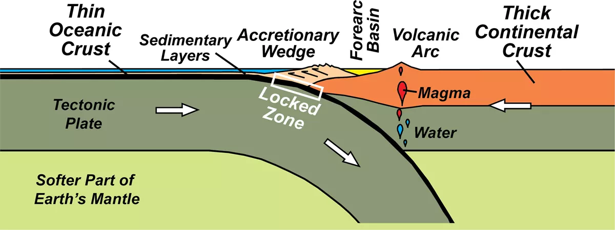
Simplified depiction of a subduction zone. Image by National Park Service (public domain).
As the Farallon plate subducted under the North American Plate, part of the Farallon plate was “scraped off” in she shape of a folded carpet onto the leading edge of the North American Plate, labelled as the accretionary wedge. We see this wedge today as the hills and valleys of the Coast Ranges, a NW-SE oriented series of mountain ranges that spans from the Pacific Ocean to the western edge of the Central Valley, and includes the Bay Area.
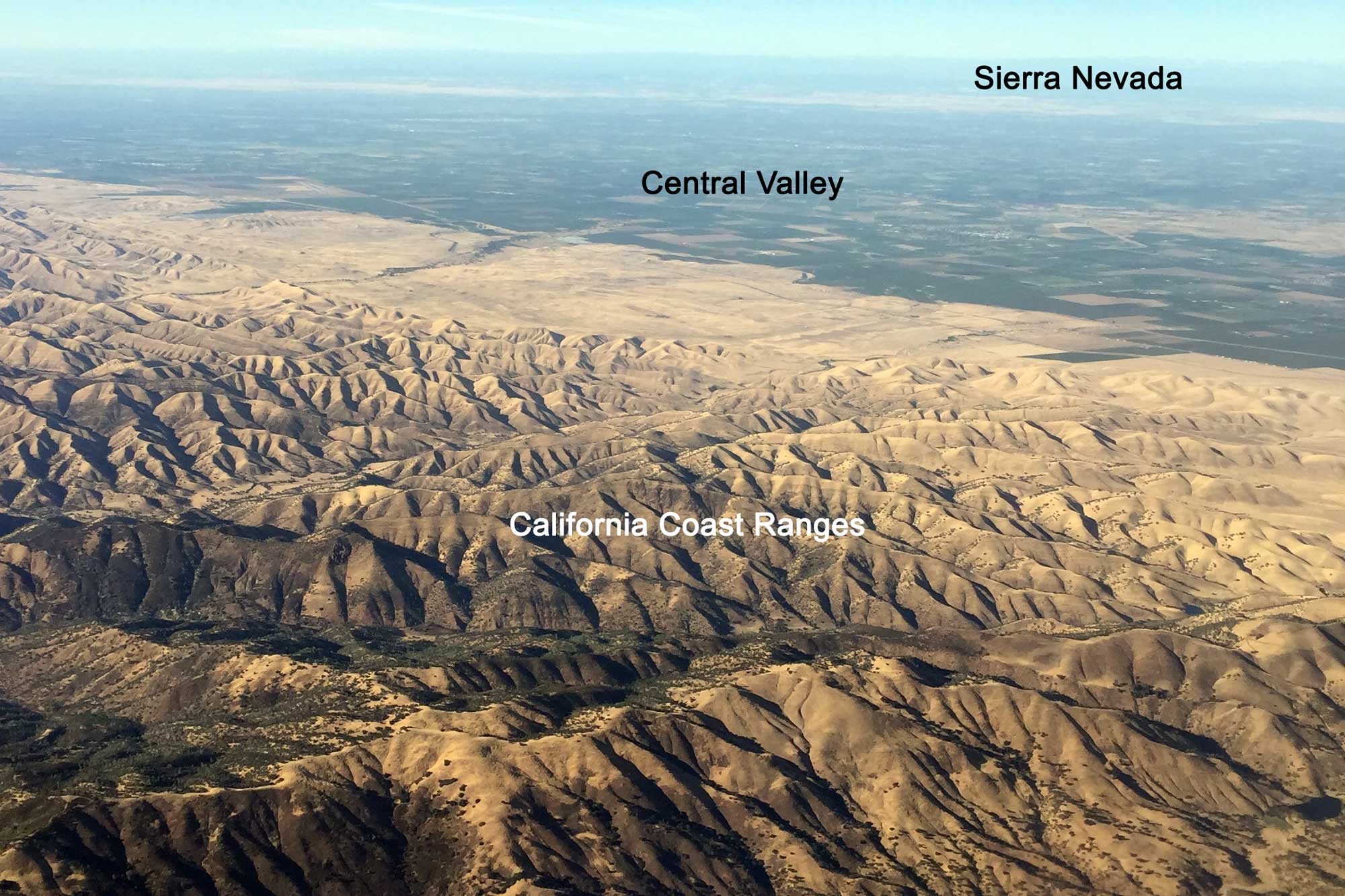
Aerial photograph of California's Central Valley and Coastal Ranges; the Sierra Nevada Mountains are visible in the background. Photograph by Jonathan R. Hendricks.
East of the accretionary wedge, a broad, flat valley was created as the subducting Farallon plate dragged the crust down with it, labelled as forearc basin. This basin was below sea level for millions of years, during which it existed as a shallow inland sea, where thousands of feet of sediments like sand and silt accumulated. We see this area today as California’s Central Valley.
As the Farallon plate subducted downward into the interior of the Earth, it eventually reached deep enough for some of the minerals to melt. The minerals with the lowest melting temperatures melted first as temperatures began to rise. These minerals, which happen to also be less dense than the surrounding rocks, began to work their way upward through the crust to the surface, where they built up in magma chambers for millennia before erupting as a series of volcanoes spanning the whole west coast of North America. Active volcanism still exists to the north and south of California, where convergent plate boundaries still exist, but here in California, as soon as the “conveyor belt” of Farallon plate crust was shut off, so was the source for most of our larger volcanoes, which began to go extinct around the time that Farallon subduction ceased. Over the eons, the volcanic rocks erupted out of those volcanoes have largely been eroded away, and we see the remnants of the magma chambers that fed those volcanoes preserved as the granite of the Sierra Nevada.
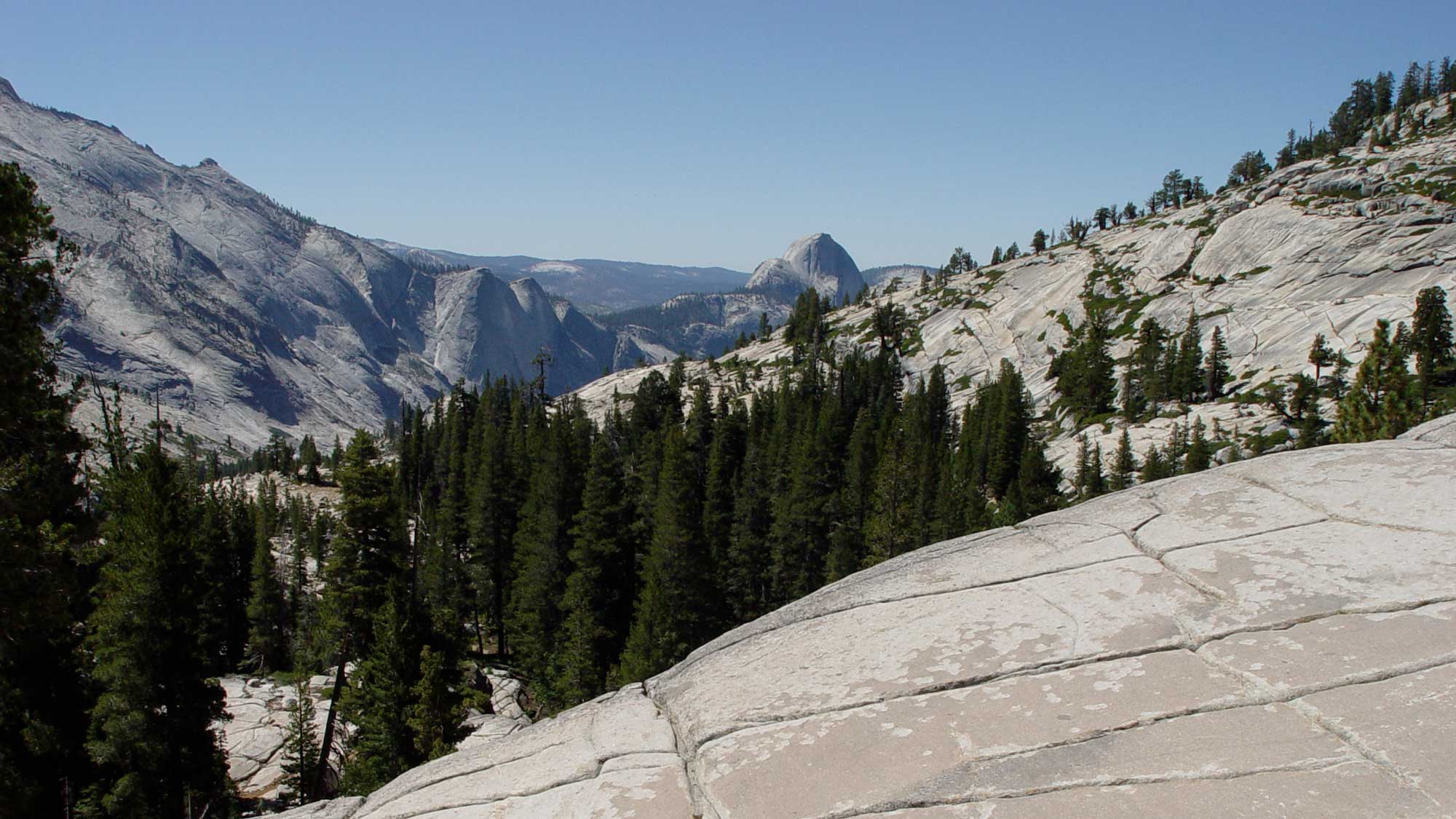
Granite rock of the Sierras, Olmsted Point, Yosemite National Park, California. Photograph by Jonathan R. Hendricks.
Around 30 million years ago, the western edge of the Farallon plate finally began to slip under North America, bringing the Pacific and North American plates into direct contact, and changing part of that convergent boundary into a transform boundary in which two tectonic plates slide past one another. Over the 30 million years since then, the transform plate boundary has extended both north and south, such that only a small part of northernmost California, in Humboldt and Del Norte counties, currently lies along a convergent boundary.
Transform plate boundaries can produce large earthquakes (magnitude 7-8), but not as large as the “great” earthquakes of magnitude 9.0+ that can occur along convergent boundaries. Earthquakes along transform boundaries are also much less likely to cause tsunamis than convergent boundaries, because two pieces of Earth’s crust slipping past one another are much less likely to displace ocean water. (At a convergent boundary, the overlying plate may buckle and rebound upward as the underlying plate slips underneath, displacing water and forming a tsunami.)
The San Andreas Fault
The transform plate boundary that now runs nearly the entire length of California is dominated by the infamous San Andreas Fault, a textbook example of a strike-slip fault, in which two blocks of Earth’s crust slide past one another.
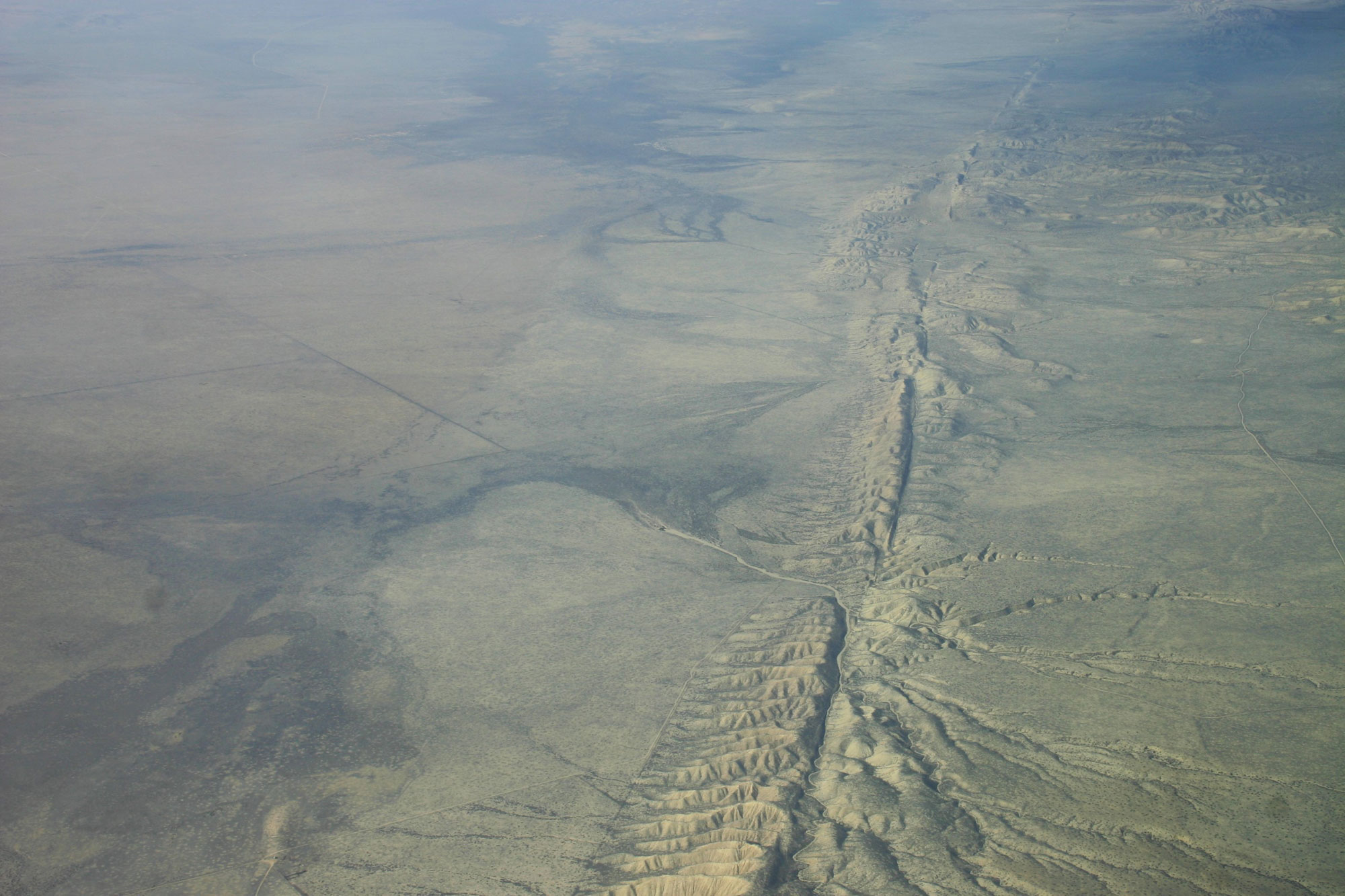
Aerial photo of the San Andreas Fault, Carrizo Plain, California. Photo by Ikluft (Wikimedia Commons, Creative Commons Attribution-ShareAlike 4.0 International license, image resized).
The San Andreas Fault (SAF for short) itself is considered the plate boundary, so that when you cross the SAF, you cross from the Pacific to the North American Plate, or vice-versa. Many people don’t realize, however, that most transform plate boundaries consist of a primary fault and secondary, sub-parallel faults. The San Andreas is just one discrete fault within the larger San Andreas Fault system, which includes several other sub-parallel strike-slip faults, such as the Hayward/Rodgers Creek, Calaveras, Concord/Green Valley, West Napa, Greenville, and San Gregorio faults.
Bay Area landscapes and tectonics
In addition to the earthquake hazards posed by the San Andreas fault system, the faults also shape the landscape of the Bay Area. The rocks west of the San Andreas Fault are completely different than those east of the SAF, with those to the west having been transported up to 300 km north. The Point Reyes Peninsula in Marin County is an excellent example of this; the chemical composition of the granite blocks there match the granite seen in the Sierra Nevada and in the mountains of Southern California. As shown in the figure below, the mountains and valleys of the Bay Area generally correspond with the fault traces in the region.
KEENE - IMAGE NOT RECEIVED - PLEASE SEND
Most strike-slip faults have some component of vertical motion, meaning that during an earthquake, although 80-90% of the motion may be slipping side-by-side, the remaining 10-20% of the motion is one plate moving up or down relative to the other. This creates mountains on the upthrown block, and valleys, which are later filled in with sediment, on the downthrown block. San Francisco Bay itself exists within the downthrown block between the San Andreas Fault and the Santa Cruz Mountains to the west, and the Hayward fault and the East Bay Hills to the east. Similarly, the valleys of the inland East Bay occupy the downthrown block of the Calaveras fault, adjacent to the East Bay Hills in the upthrown block. Many more examples of this exist throughout the Bay Area, including Napa Valley, which is in the downthrown block of the West Napa fault, and Fairfield/Cordelia, which is in the downthrown block of the Green Valley fault.