


CONTENTS
The Fit of Continents
When you were a child, did you ever look at a world map and imagine the continents as puzzle pieces? Some almost look like they might fit together. For example, the east coasts of the Americas look like they could be directly connected to the western shores of Africa and Europe.
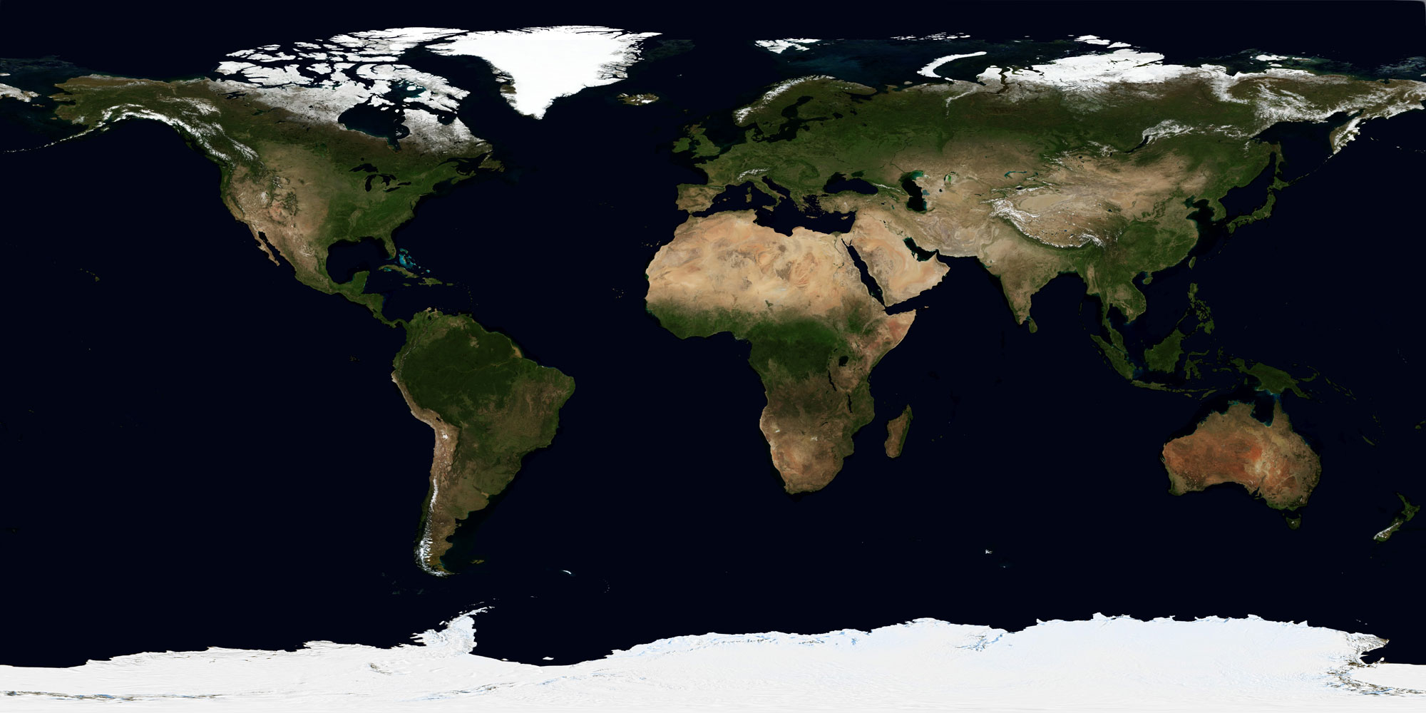
Map of the Earth based on satellite image data collected during June 2004 (NASA; public domain).
The imaginations of people have gone in this direction for almost as long as there have been maps of the world. The first person to suggest that the continents look like they might fit together was Abraham Ortelius (1527-1598), who--not coincidentally--published the first world atlas in 1570. Nearly 300 years later, a similar thought occurred to geographer Antonio Snider-Pellegrini (1802-1885), who built on the daring hypothesis first suggested by Ortelius: the continents look like they might fit together because they were once connected. Snider-Pellegrini went a step further and published sketches of maps that imagined a world with continents that were once connected into what we would now call a supercontinent.
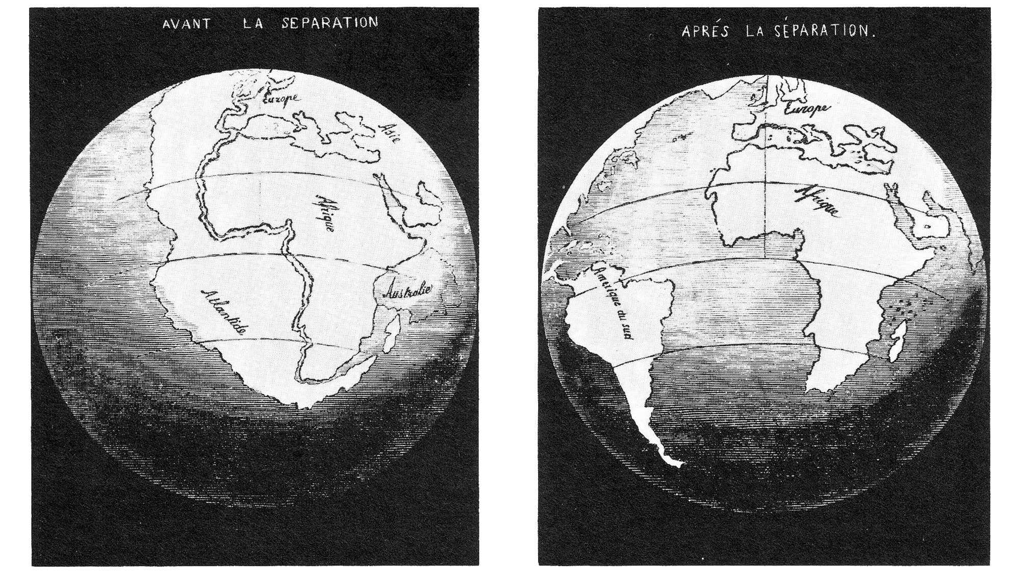
Antonio Snider-Pellegrini was the first person to publish a map showing connected continents (Wikimedia Commons; public domain).
When Snider-Pellegrini published his map of a supercontinent in 1858, the idea that the positions of the continents had changed over time was little more than conjecture. Over the next 60 years, though, additional evidence began to accumulate in support of this hypothesis, which came to be known as the idea of continental drift.
Evidence for Continental Drift
In the late 1800s and early 1900s, evidence began to grow in support of the hypothesis that the continents had once been connected and had subsequently moved apart over time. A leading proponent of this idea was a German meteorologist named Alfred Wegener (1880-1930). In 1912, Wegener presented evidence that most of the continents of the Earth were once connected in a supercontinent that he called Pangea (alternatively spelled Pangaea); he published the reconstructions of Pangea shown below in 1929.
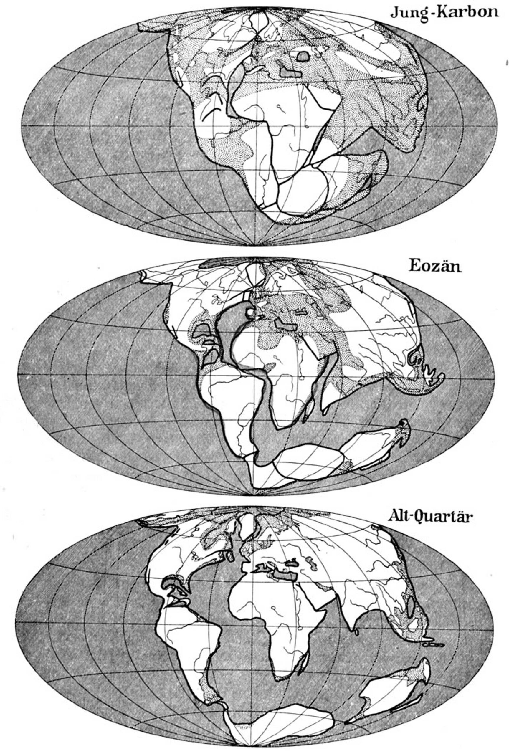
Maps showing the breakup of the supercontinent published by Alfred Wegener in 1929 (Wikimedia Commons; public domain). The time intervals depicted include the Carboniferous (top), Eocene (middle), and Quaternary (bottom).
Wegener, as well as a small number of geologists, presented five main lines of evidence in support of continental drift during the 1910s and 1920s. The first line of evidence has already been introduced above: the shapes of the continents themselves. Several of the other lines of evidence in support of continental drift included distributions of fossils, glacial indicators, and distinctive rock sequences found around the world. These are introduced below.
Distributions of Fossils
One of the most compelling lines of evidence in support of continental drift came from the fossil record. In particular, very similar types of fossils were found in now far-flung regions of the world. Two examples include the aquatic reptile Mesosaurus and the plant Glossopteris.
Mesosaurus
Mesosaurus was a small (~1 m long) aquatic reptile that inhabited shallow shorelines during the Permian period.
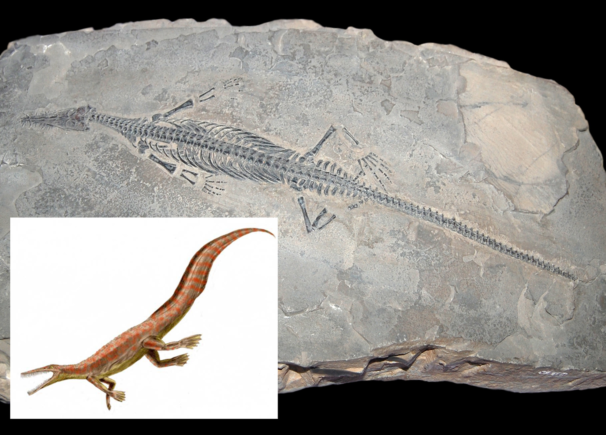
Fossil skeleton of a specimen of Mesosaurus on display at the Museo civico di storia naturale Milano; photograph by "FunkMonk" (Wikimedia Commons; Creative Commons Attribution 2.0 Generic license). Inset image shows a reconstruction of Mesosaurus by Nobu Tamura (Wikimedia Commons; Creative Commons Attribution-ShareAlike license).
Fossil specimens of Mesosaurus have only been found in two regions: southern Africa and South America. The map below (based on data in the Paleobiology Database) shows locations where these fossils have been found.
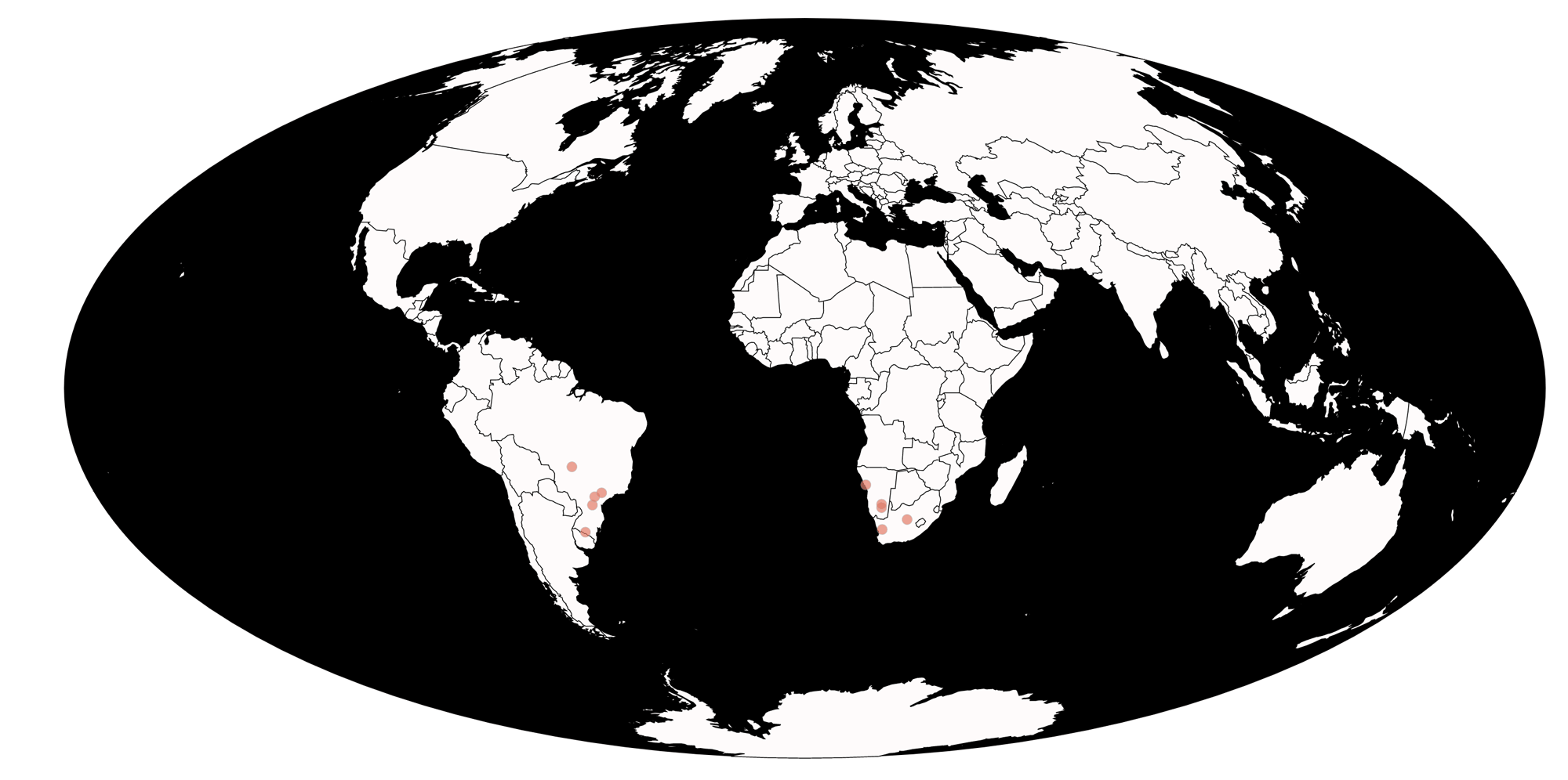
Occurrences (red dots) of the Permian reptile Mesosaurus (data and map from the Paleobiology Database Navigator).
This distribution presents an immediate conundrum: how was this small reptile able to survive a journey across the entire Atlantic ocean? At one point, some paleontologists and geologists argued that a land bridge (that would have facilitated the movements of organisms from one continent to the other) must have once connected South American with Africa, but later sunk. The land bridge hypothesis, however, did not stand up to scrutiny: 1) there is no evidence for a sunk bridge under the ocean; and 2) continental crust cannot sink below oceanic crust because it is less dense.
The distribution of Mesosaurus, of course, makes much more sense if the continents were once connected and subsequently broke apart. The map below shows the positions of the continents 275 million years ago, during the Permian period. The red points, which indicate places where fossils of Mesosaurus have been found, suggest a much more constrained range when considered in the context of the Permian paleogeography when these animals were alive.
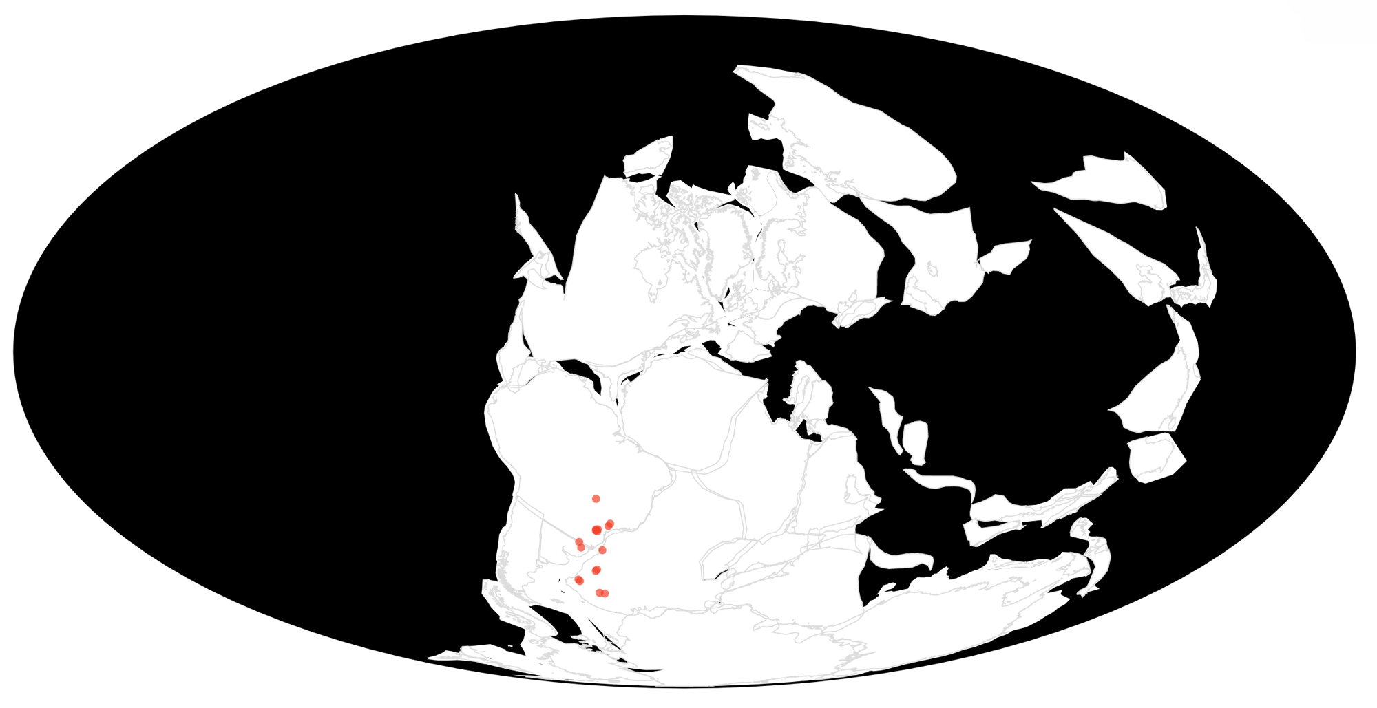
Occurrences (red dots) of the Permian reptile Mesosaurus, with tectonic plates rotated back to their positions during the Permian period (275 million years ago) (data and map from the Paleobiology Database Navigator, utilizing plate rotations from GPlates).
Glossopteris
Another type of fossil that provided early support for continental drift was the ancient "seed fern" plant Glossopteris. The leaves of Glossopteris are named for their tongue-like shape (the prefex "glosso-" is Greek for tongue; the suffix "-pteris" refers to a fern). Glossopteris plants grew into shrubs or tall trees that produced large seeds.
Fossil leaves of the pteridosperm Glossopteris sp. from the Permian Polestar Formation of the Ellsworth Mountains of Antarctica (PRI 49674). Specimen is on display at the Museum of the Earth, Ithaca, New York. Length of specimen is approximately 13 cm.
Glossopteris lived during the Permian period and, among other places, fossils of this plant have been found in South America, Africa, Madagascar, India, Australia, and--remarkably--Antarctica.
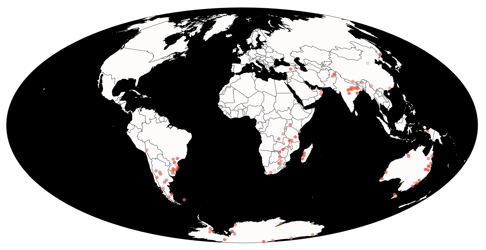
Occurrences (red dots) of the Permian seed fern Glossopteris (data and map from the Paleobiology Database Navigator).
The presence of Glossopteris in Antarctica makes little sense unless the continents were once connected. Today, it is much too cold, and too dark much of the year, for any large plants to survive on Antarctica. Its occurrence, therefore, in Antarctica's fossil record implies that the environment of Antarctica has changed substantially over the last 250 million years. The occurrence of Glossopteris in so many other places besides Antarctica also presents a challenge. The seeds of this plant were much too large to be carried by the wind. How then did they reach Antarctica? Or, alternatively, how did they get from Antarctica to other continents? As was the case with Mesosaurus, the modern distribution of Glossopteris fossils makes much more sense if the continents were once connected as a supercontinent, as shown in the reconstruction below.
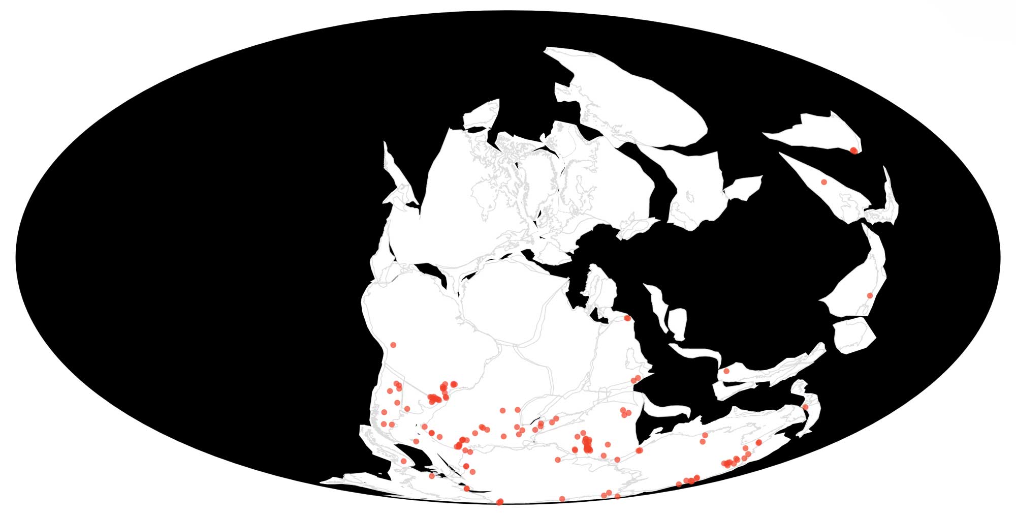
Occurrences (red dots) of the Permian seed fern Glossopteris, with tectonic plates rotated back to their positions during the Permian period (275 million years ago) (data and map from the Paleobiology Database Navigator, utilizing plate rotations from GPlates).
Glacial Indicators and Distinctive Rock Sequences
Geological features left behind by the movement of glacial ice provided an additional line of evidence of support for Wegener and his colleagues that continental drift had occurred. Glaciers carry rocks along at their base as they move and these rocks leave behind scratch marks called striations in the bedrock that are parallel to the direction of glacial flow. (Imagine the marks that would be left behind if you dragged a rake behind yourself while walking along a sandy beach; glaciers leave similar types of marks behind.) Glaciers also leave behind a distinctive type of sediment called till when they melt. Till is composed of all of the rocks and sediments that were carried along by the glacier as it moved, including clay, sand, and cobbles and boulders that frequently are very different in composition from the surrounding bedrock. Such glacial erratics have a different composition because they traveled with the glacier, originating in an area with a very different geological history.
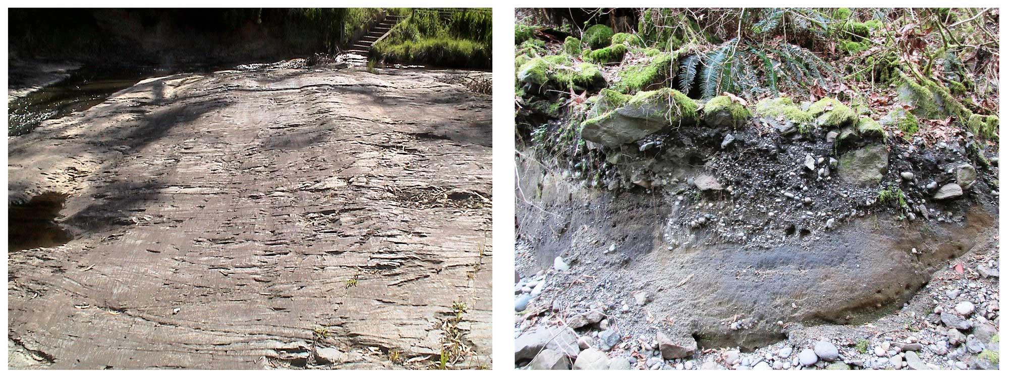
Left: Glacial striations in Permian-aged bedrock at Selwyn Rock, Inman River, South Australia; photograph by "Bahudhara" (Wikimedia Commons; Creative Commons Attribution-Share Alike 3.0 Unported license). Right: A deposit of glacial till exposed along Boeing Creek, Shoreline, Washington; photograph by "brewbooks" (Wikimedia Commons; Creative Commons Attribution-Share Alike 2.0 Generic license).
When geologists study late Paleozoic to Mesozoic-aged rocks in South America, Africa, India, Australia, and Antarctica, they find a very distinctive sequence of rock types that is found in each continent. At the bottom of the sequence, in Carboniferous-aged rocks, they find bedrock with glacial striations that is overlain by glacial till. Above this, they find Permian-aged rocks that bear fossils of Glossopteris and coal layers are frequently also evident. These Paleozoic rocks are in turn often overlain by sandstone, and then basalt lava flows.
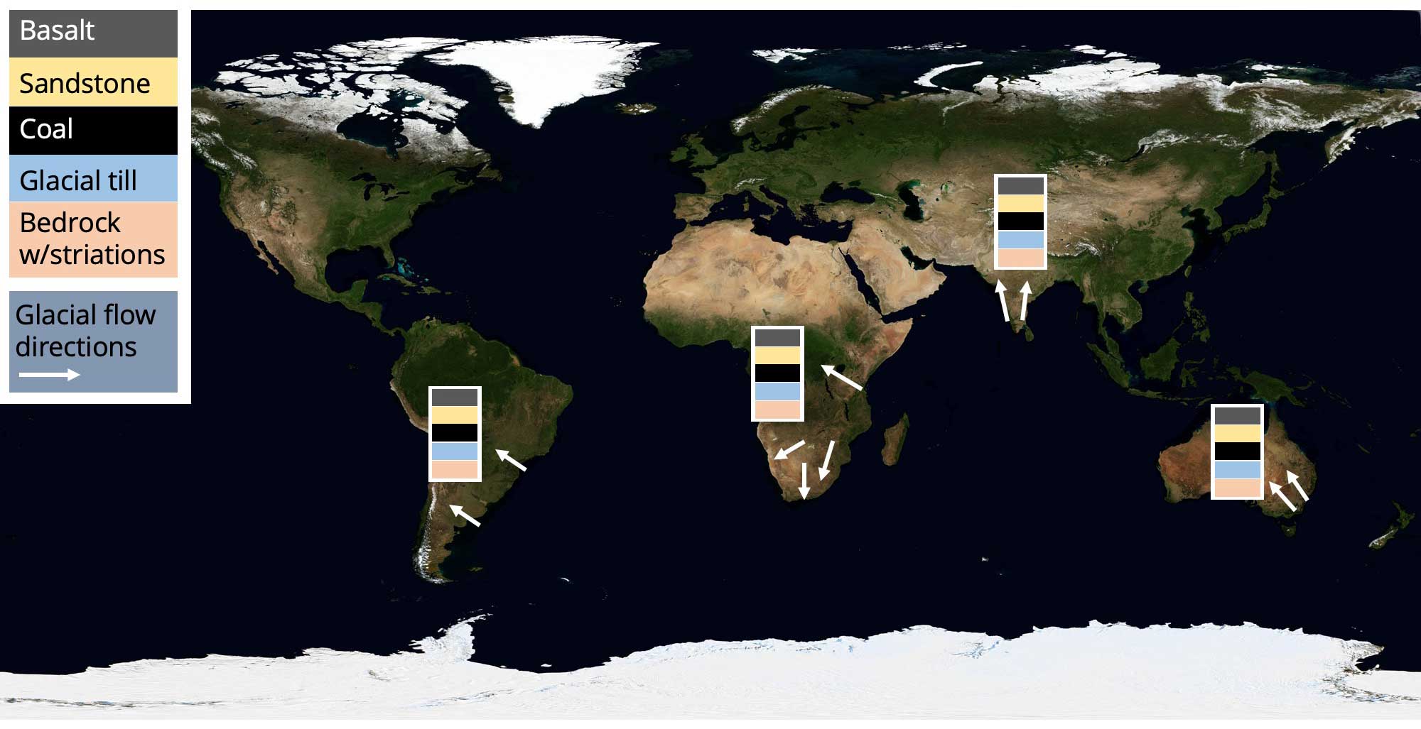
Very similar sequences of late Palezoic to early Mesozoic rocks are found in southern South America, southern Africa, India, and Australia. Glacial striations are carved into the bedrock at the bottom of these sequences; arrows on the map indicate directions of glacial flow. Base map by NASA (public domain).
The odds that this exact same sequence of rocks would be found in rocks of the same age on different continents is very low. If the continents were once connected, however, this common sequence of rocks makes much more sense, as it would reflect a shared geological history within a single large region.
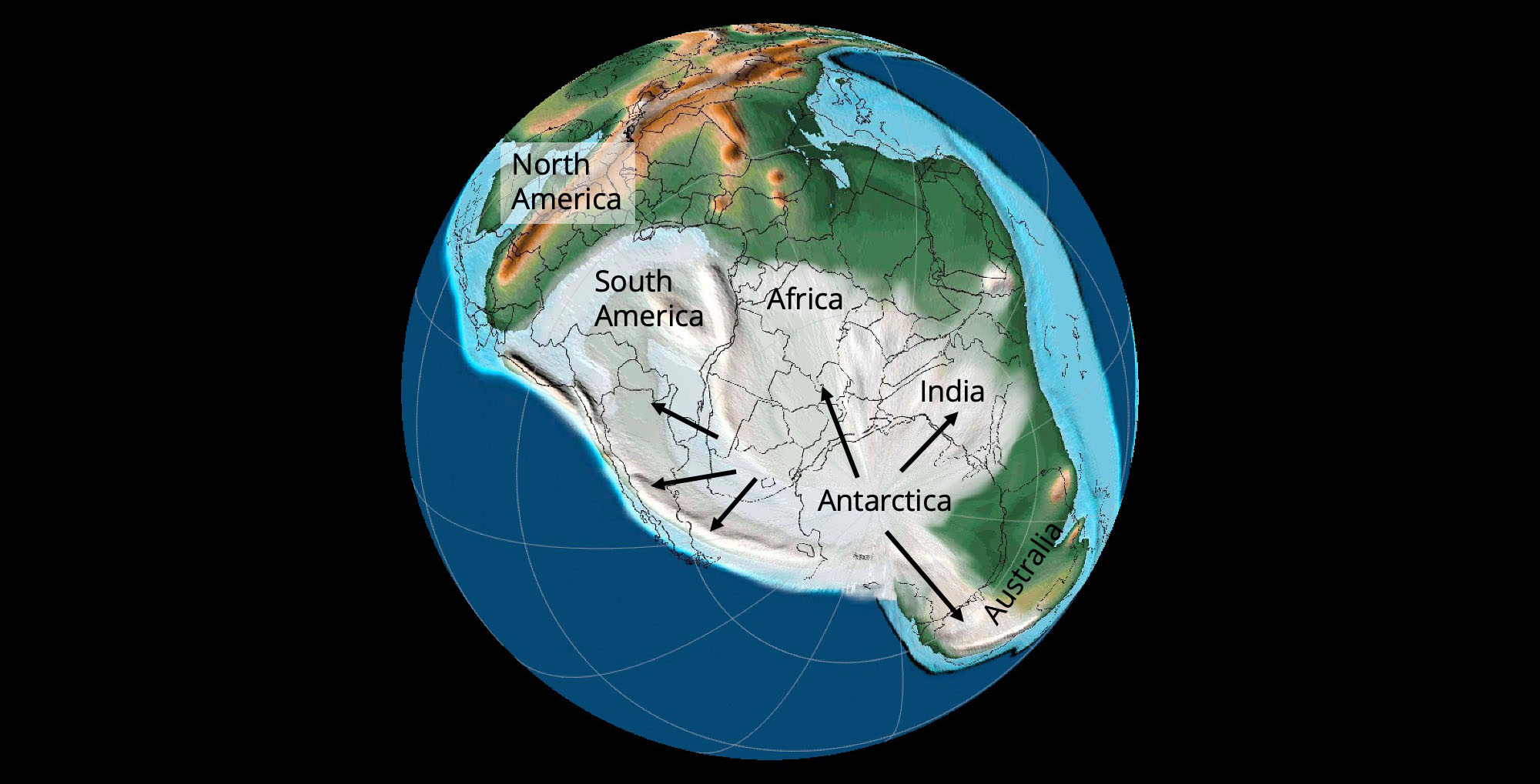
Reconstruction of Earth's paleogeography 315 million years ago (Carboniferous Period). Arrows depict glacial flow directions recorded as striations in Carboniferous-aged bedrock (see image above). Base map created using PALEOMAP PaleoAtlas for GPlates by Scotese (2016).
The hypothesis that the continents were once connected also helps to better explain the glacial striations and tills found in South America, Africa, India, and Australia. This body of evidence suggests that these areas were once connected and covered by glacial ice, which flowed outwards from Antarctica. Geologists refer to this collection of once-connected southern continents as Gondwana. Gondwana was a major component of Pangea, which fully formed at the end of the Paleozoic era.
Summary
Alfred Wegener and other early supporters of the hypothesis of continental drift provided diverse evidence in support of their view that the positions of the continents had changed over time. This evidence ranged from the shapes of the continents themselves, to clues from both the fossil record and the physical rock record. Despite all of this evidence, which was presented during the 1910s and 1920s, few geologists accepted the hypothesis that the positions of the continents had changed over time. One important reason for this is that Wegener had not presented a convincing mechanism that could move continents across Earth's surface. Wegener suggested that tidal forces in Earth's crust were responsible for moving the continents, but this mechanism was viewed by both his contemporaries and modern geophysicists as incorrect. For the next 40 years, geologists largely disregarded the idea of continental drift.
It was not until the 1960s that most geologists became convinced that the core component of Wegener's hypothesis—the movement of continents—was correct. As described on the next page, the plate tectonics revolution came about following the discovery of additional evidence that supported the movement of continents, but more importantly the development of a convincing explanation for the mechanism that drives such movement.
References and Further Reading
Hallam, A. 1975. Alfred Wegener and the hypothesis of continental drift. Scientific American 232(2): 88-97.
Scotese, C. R. 2016. PALEOMAP PaleoAtlas for GPlates and the PaleoData Plotter Program, PALEOMAP Project. Link.