

Page snapshot: Introduction to the geologic history of North America.
Topics covered on this page: Reconstructing the geologic past; The Earth's crust; Understanding plate boundaries; Geologic Time.
Credits: Most of the text of this page is derived from "Geologic history of the Southeastern US" by Warren D. Allmon, Jane A. Picconi, Stephen F. Greb, and Charles C. Smith, chapter 1 in The Teacher-Friendly Guide to the Geology of the Southeastern U.S., 2nd. ed., edited by Andrielle N. Swaby, Mark D. Lucas, and Robert M. Ross (published in 2016 by the Paleontological Research Institution; currently out of print). The book was adapted for the web by Elizabeth J. Hermsen and Jonathan R. Hendricks in 2021. Changes include formatting and revisions to the text and images. Credits for individual images are given in figure captions.
Image above:
Reconstructing the geologic past
Geologic history is the key to this guide and to understanding the story recorded in rocks. By knowing more about the geologic history of your area, you can better understand the types of rocks that are in your backyard and why they are there. In the "Here on Earth" section of this website, we will look at the geologic history of the United States as it unfolded in a series of major events that created and shaped the area over the past several billion years.
Reconstructing the geologic past is a lot like solving a mystery. Geologists use scraps of evidence to piece together events they have not personally observed, but to do so they must contend with two major problems. First, the overwhelming majority of geologic history occurred long before there were any human witnesses. Second, much of the evidence for older events is highly fragmented. By studying rocks, fossils, and other geologic features, however, scientists can still reconstruct a great deal of what the ancient Earth might have looked like.
Ultimately, geologists rely upon the preserved clues of ancient geologic processes to understand Earth's history. Because younger environments retain more evidence than older environments do, the Earth's recent history is better understood than its ancient past. Although preserved geologic clues are indeed fragmentary, geologists have become increasingly skilled at interpreting them and constructing an ever more detailed picture of the Earth's past.
The Earth's crust
The shape and position of the continents have changed dramatically over the last billion years, and geologic processes continue these changes today. The Earth's outer layer—the crust—is dynamic, consisting of constantly moving plates that are made of a rigid continental and oceanic lithosphere overlying a churning, plastically flowing asthenosphere (the outer part of the Earth's mantle). These plates are slowly pulling apart, colliding, or sliding past one another with great force, creating strings of volcanic islands, new ocean floor, earthquakes, and mountains. The continents are likewise continuously shifting position relative to each other. These movements not only shape the land, but also affect the distribution of rocks and minerals, natural resources, climate, and life on Earth.
Active plate margins are the boundaries between two plates of the Earth's crust that are colliding, pulling apart, or sliding past each other as they move over the mantle. Some of these plates move as fast as 10 centimeters (4 inches) per year. The processes of plate movement, spreading, subduction, and mountain building are collectively called plate tectonics.
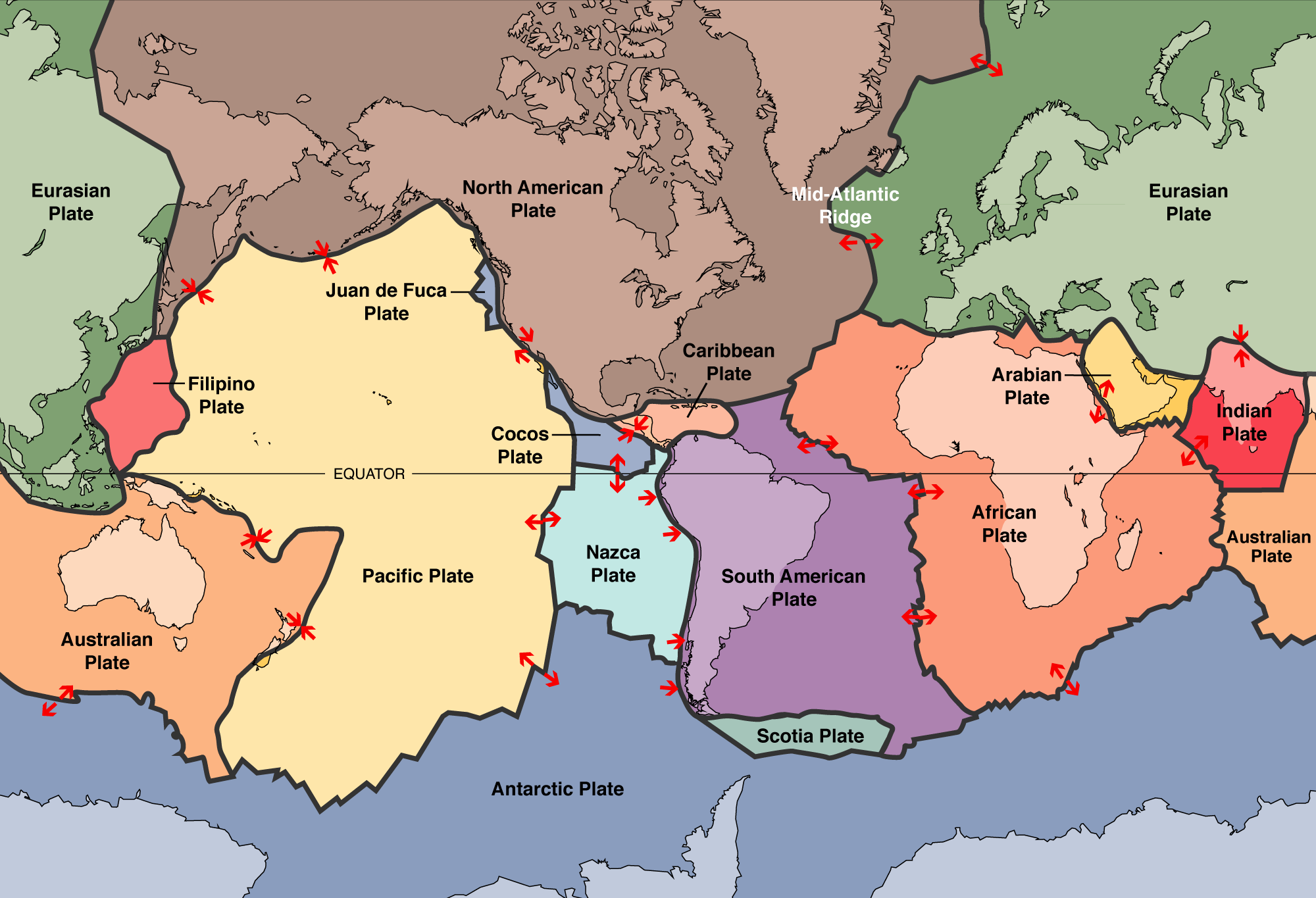
World map showing the boundaries of the tectonic plates. The North American Continent takes up only part of the North American plate (brown). The Mid-Atlantic Ridge, a spreading center (in other words, a place where plates are moving away from one another) is also labelled. The arrows indicate the directions of plate movement. Map modified from USGS tectonic plates map, via Wikimedia Commons (public domain).
Lithosphere and Asthenospere: What’s the difference?
The lithosphere is the outermost layer of the Earth. It is rigid layer of crust and upper mantle that is broken up into large fragments called plates. The asthenosphere is the layer of the Earth below the lithosphere. Although the rock of the asthenosphere would seem very solid if you could look at it, under long-term stress it slowly bends and flows, like very thick syrup.
The boundary between the rigid lithosphere and flowing asthenosphere is found in the mantle, the region between the Earth's crust and its core. This transition from lithosphere to asthenosphere is caused by increasing temperature, which is correlated with increasing depth beneath the Earth's surface. In tectonically active regions of extension (essentially, regions where crust is stretching and new crust is formed), such as mid-ocean ridges, temperature rises rapidly with depth. Thus, the asthenosphere begins nearly at the base of the crust. In more tectonically stable regions, temperature increases more slowly with depth. In these regions, the asthenosphere may begin deeper within the mantle.
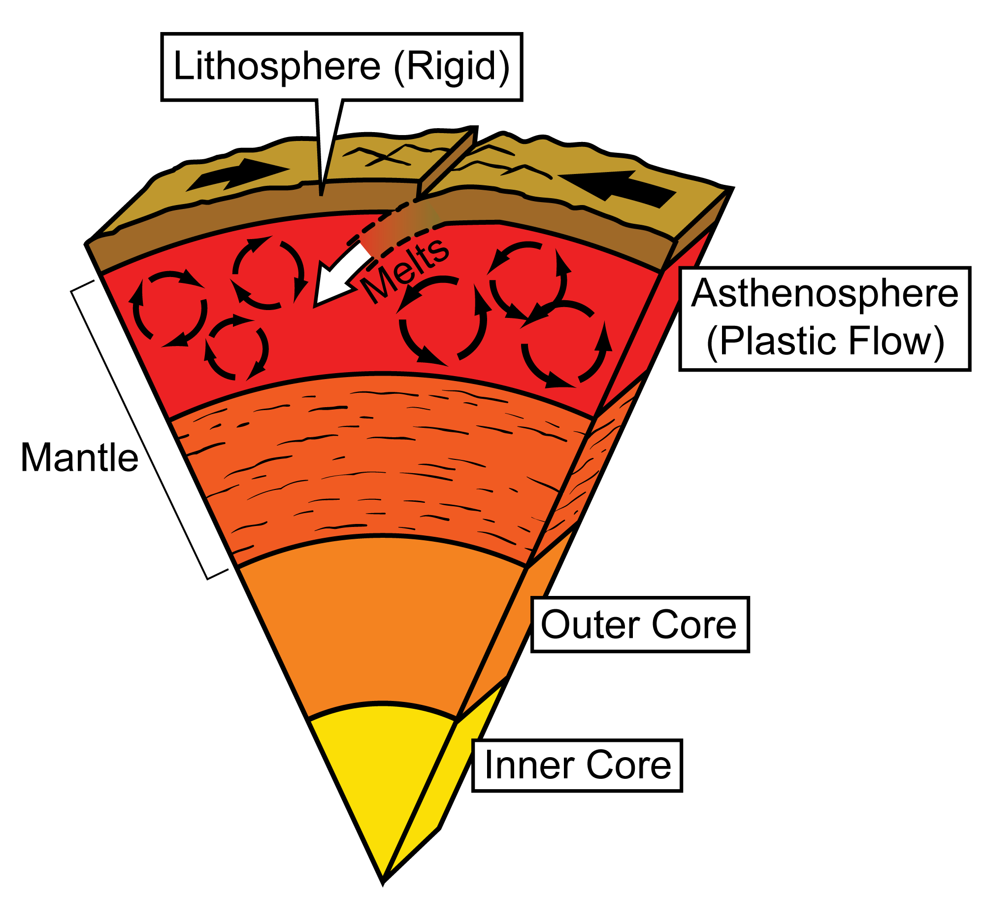
A cross-section of the Earth showing the layers from the center (inner core) to the surface (lithosphere). Note that the solid crust that makes up the lithosphere sits on the outer part of the mantle, which is called the asthenosphere. The asthenosphere exhibits plastic flow, like a very thick liquid. Over time, this allows the plates of the lithosphere to shift and move on the asthenosphere. Image modified from original by Jim Houghton, first published in The Teacher-Friendly Guide to the Geology of the Southeastern U.S., 2nd ed., edited by Andrielle N. Swaby, Mark D. Lucas, and Robert M. Ross (published by the Paleontological Research Institution) (CC BY-NC-SA 4.0 license).
The difference between crust and mantle is mainly chemical. The lithosphere's composition typically varies from mafic basalt in oceanic crust to felsic granite in continental crust. The mantle is composed of homogenous ultramafic material. The differences among felsic, mafic, and ultramafic rocks are as follows:
- Felsic rocks are igneous rocks that are high in silica and low in iron and magnesium, making them light in color. Quartz and feldspar are examples of felsic minerals; granite is a type of igneous rock that is at least 20% quartz by volume.
- Mafic rocks are igneous rocks that contain dark-colored minerals that are high in magnesium and iron. Olivine is an example of a mafic mineral that may be found in basalt, an igneous rock.
- Ultramafic rocks are mafic rocks that are low in silica (less than 45% silica) and that are usually composed of more than 90% mafic minerals. Peridotite is an example of an ultramafic rock.
For further discussion of igneous rock classification, see Here on Earth: Introduction to Rocks.
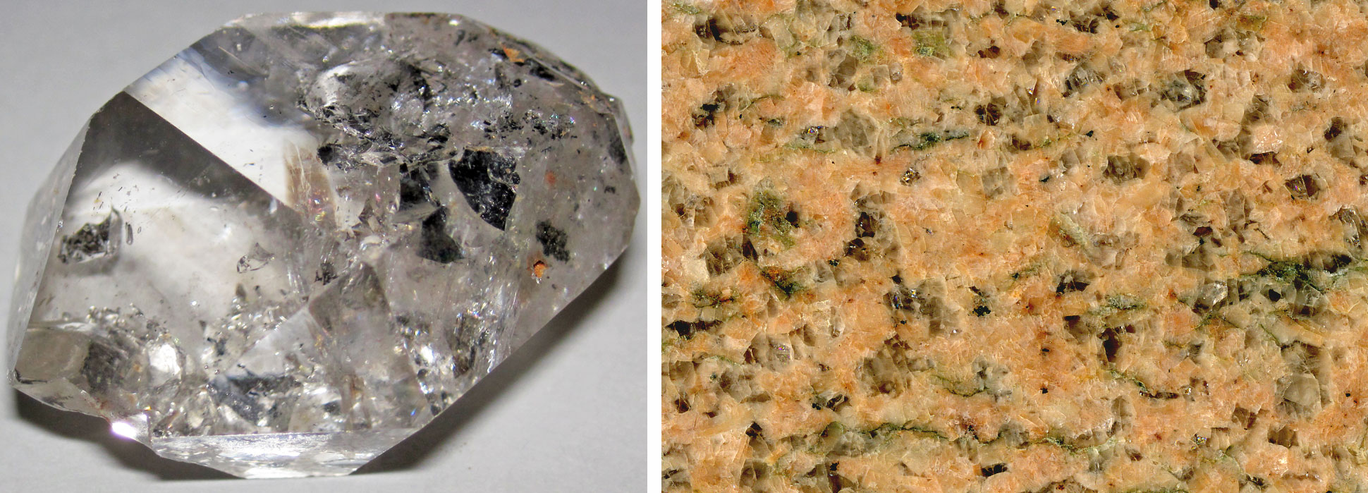
Felsic minerals and rocks. Left: A herkimer diamond, not a true diamond but a type of quartz found in the region of Herkimer, New York. Photo by James St. John (flickr, Creative Commons Attribution 2.0 Generic license, image cropped and resized). Right: Salisbury pink granite from North Carolina. Photo by James St. John (flickr, Creative Commons Attribution 2.0 Generic license, image cropped).
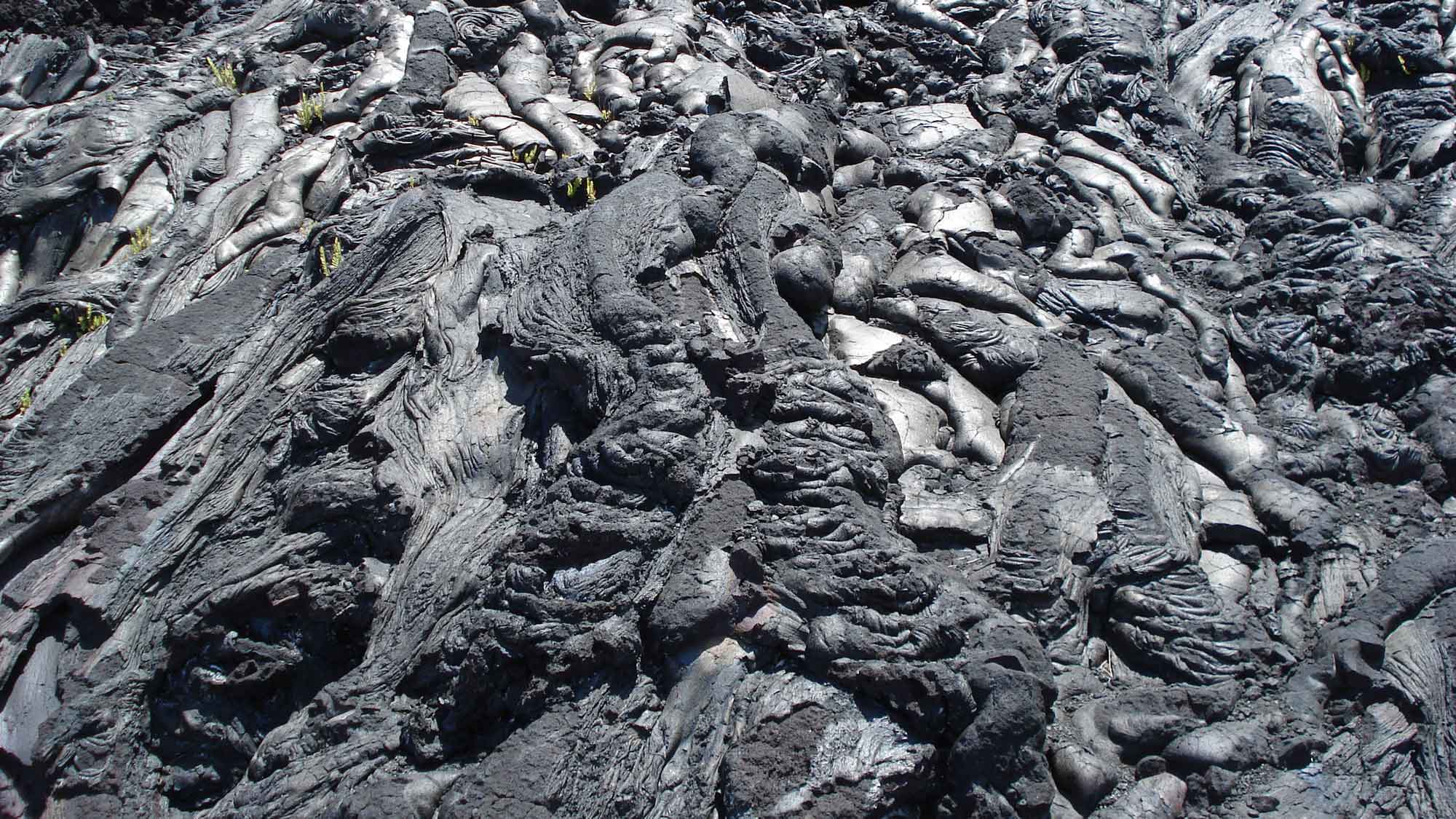
Recently-erupted basalt lava (a mafic igneous rock) on the Big Island of Hawai'i. Photograph by Jonathan R. Hendricks (Earth@Home).
Understanding Plate Boundaries
There are three major types of plate boundaries that are explained below:
- Convergent boundary: when one plate slides beneath another or when two plates collide and crumple at their margins. These boundaries are associated with orogenies (mountain-building events).
- Divergent boundary: when plates pull apart from each other or when a plate begins to break apart to form one or more separate plates.
- Transform boundary: when plates slip past each other in opposite directions.
Convergent boundaries
Convergent boundaries occur when plates collide. There are two major types of convergent boundaries: those that occur when continental and oceanic crusts collide, and those that occur when two continents collide.
Subduction zones
Subduction zones can occur when continental crust collides with oceanic crust or when oceanic crust collides with ocean crust. Continental crust, made mostly of rocks such as granite, is less dense but much thicker than oceanic crust. Oceanic crust is made mostly of dense rocks such as basalt. The higher density of the oceanic crust means that when continental crust collides with oceanic crust, the denser oceanic crust will usually be dragged (or subducted) under the buoyant continental crust. The water in the subducting plate is carried deep into the mantle and causes the melting of the overlying mantle rock. The resulting magma is hot and buoyant, so it rises to the surface and creates volcanoes. The Cascade volcanoes are an example of this type of convergent boundary.
The subduction of an oceanic plate beneath a continental plate as they collide produces an accretionary wedge. These rocks, which include deep-sea sediments overlying the crust, the oceanic crust itself, and rock from the upper mantle, are scraped off the descending plate and attached to the continental crust. If the rocks are forced up onto the continental crust and exposed at the surface, the are called ophiolites.
Perhaps one of the most dramatic subduction zones formed by the convergence of a continental and an oceanic plate is found along the western coast of South America. Here, the Nazca Plate is being subducted beneath the South American Plate. As a result, the Andes Mountains have formed. The highest peak in the Andes and in South America is Aconcagua in Argentina; it is more than 6,900 meters (over 22,500 feet) tall.
Simplified diagram of a convergent boundary at which continental crust and oceanic crust are colliding. The denser oceanic crust is subducted, or forced under, the more buoyant continental crust. The oceanic crust melts as it is subducted, and an accretionary wedge forms where the oceanic plate is scraped against the continental crust. Image modified for Earth@Home from original by Jim Houghton, first published in The Teacher-Friendly Guide series (CC BY-NC-SA 4.0 license).
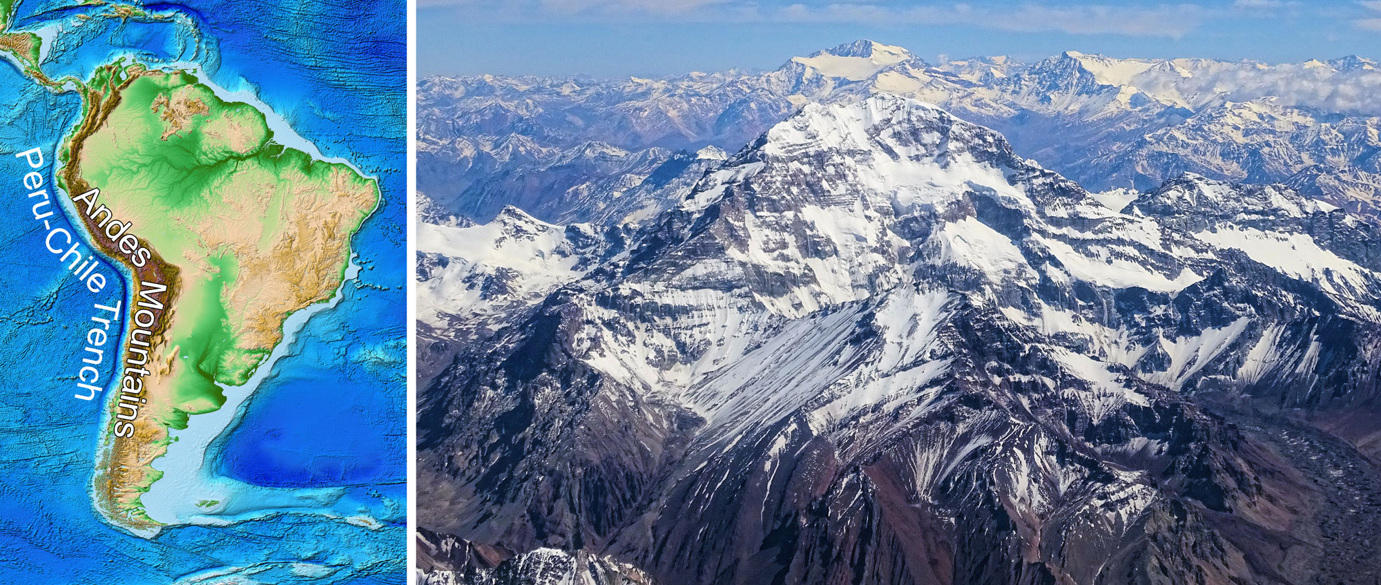
Left: Relief map of South America showing the Peru-Chile Trench off the west coast of South America and the Andes Mountains that stretch the length of the western side of the continent. Source: NOAA ETOPO1 Global Relief Model (doi: 10.7289/V5C8276M). Right: Aconcagua (foreground). Photo by Bjørn Christian Tørrissen (Wikimedia Commons, Creative Commons Attribution-ShareAlike 4.0 International license, image cropped and resized).
Islands sometimes collide with continents. Such islands occur as fragments of land on oceanic plates. As an oceanic plate is subducted beneath a continental plate, any islands on the oceanic plate will slowly creep towards the subduction zone at the edge of the continental crust. When the island gets close enough, it collides with and sticks to the edge of the continent in a process known as docking. Thus, continents can grow by accretion, meaning that they grow in area by adding small bits of land to their edges over time.
Islands may be volcanic or continental in origin. Volcanic islands may form over hot spots or regions where oceanic plates collide, causing subduction and volcanism (both scenarios are discussed further below). Some islands are exotic terranes. An exotic terrane is a piece of crustal material that has broken off from its parent continent and become attached to another plate. Because an exotic terrane originated on another continent, it will have distinctly different geologic characteristics than the surrounding rocks. For example, in the Ordovician, the Carolina Terrane collided with and attached to what is now part of the southeastern U.S., forming the Carolina Slate Belt and the Talladega Slate Belt. Florida also began as an exotic terrane, although it was not an island. It became attached to North America when North America collided with the large southern continent of Gondwana in the late Paleozoic.
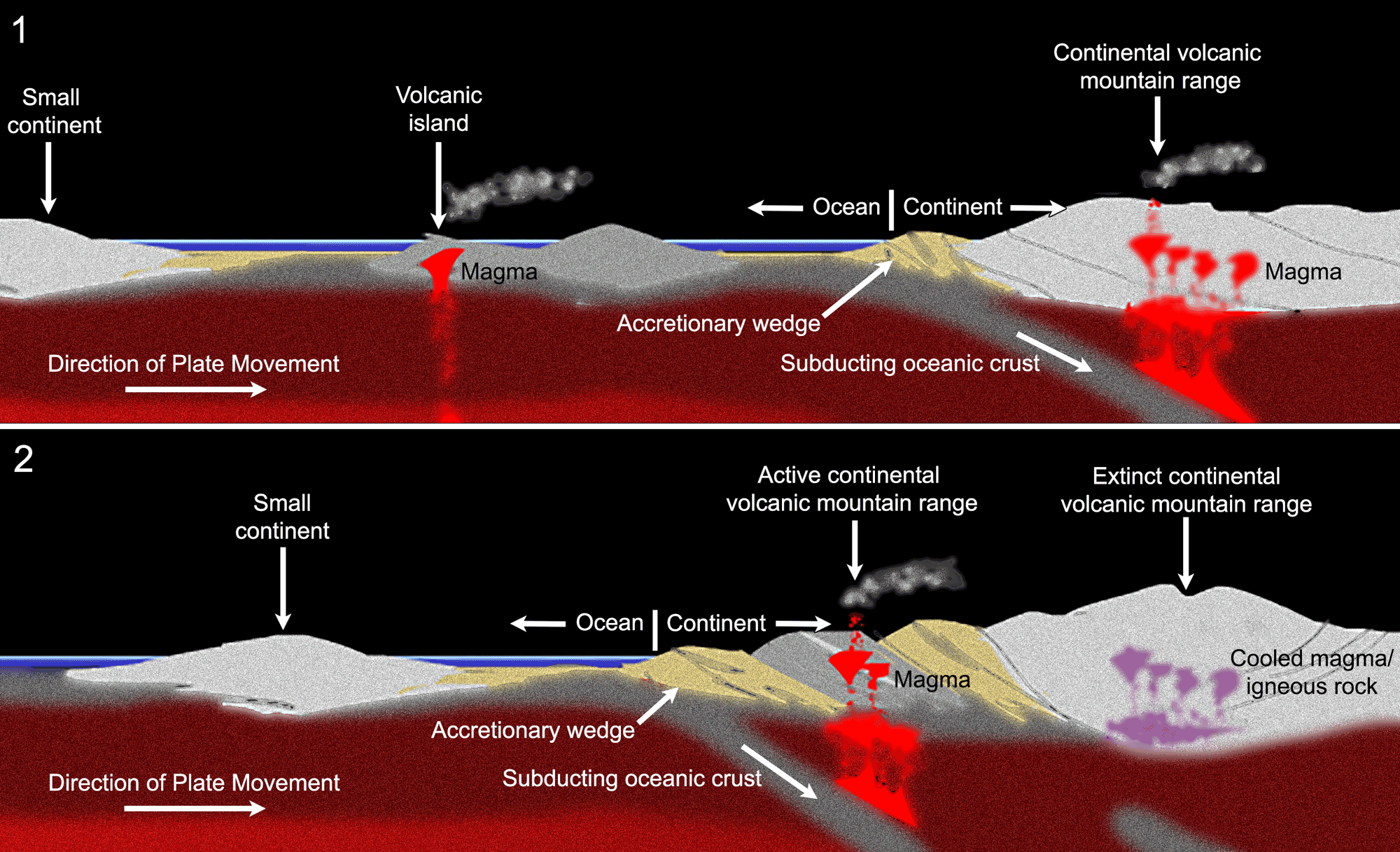
Idealized diagram showing the docking and accretion of a volcanic island at the edge of a continent. Upper diagram (1): A volcanic island (center) on oceanic crust moves toward the edge of a large continent (right). As the oceanic crust is subducted, an accretionary wedge forms at the edge of the continent and the melting oceanic crust in the subduction zone produces magma, which rises through the continental crust and forms a volcanic mountain range. Lower diagram (2): The volcanic island has docked on the edge of the continent. The active subduction zone has moved seaward, meaning that the original continental volcanic mountain range has gone extinct and an active continental volcanic mountain range has formed near the new subduction zone. The old accretionary wedge is sandwich between the extinct volcanic mountain range and the new active continental volcanic mountain range. A new accretionary wedge has formed at the active subduction zone. Image modified for Earth@Home from original by Frank Granshaw, first published in The Teacher-Friendly Guide to the Geology of the Western US (CC BY-NC-SA 4.0 license).
Volcanic island arcs
Volcanic islands are common at subduction zones between colliding oceanic plates, where one plate is subducted beneath the other. As the plates press together, friction between them generates enough heat and pressure to melt some of the crust. The molten rock rises through the crust and creates volcanoes along the edge of the overlying plate. The volcanic islands frequently form in curved lines, and are therefore called island arcs.
The Aleutian Islands, Philippine Islands, and Lesser Antilles are all modern examples of volcanic island arcs associated with subduction zones. Because island arc volcanoes mix the more mafic composition of the ocean floor with the more felsic composition of overlying sediment from continents, they are usually of "intermediate" composition along the mafic-to-felsic spectrum.
Coastal relief map of southern Alaska. The subduction trench on the border of the Aleutian volcanic island arc is clearly visible as a curving, dark blue line. The trench parallels the southern edge of the Aleutian Island chain and diverges slightly seaward as it approaches mainland Alaska (top center of the image). Source: NOAA (Lim, E., B.W. Eakins, and R. Wigley, Coastal Relief Model of Southern Alaska: Procedures, Data Sources and Analysis, NOAA Technical Memorandum NESDIS NGDC-43, 22 pp., August 2011).
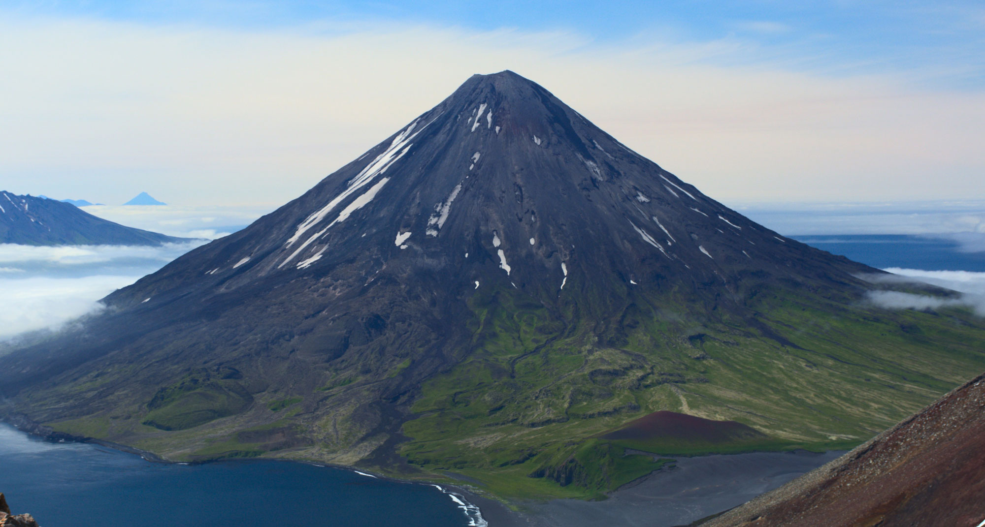
Mt. Cleveland, a volcano in the Aleutian Islands. Photo by John Lyons, USGS (via flickr, public domain).
Continent-continent collisions
Although mountains are created when oceanic and continental crust collide due to the compression of the two plates in the collision zone, taller ranges are usually produced by continent-to-continent collisions. This is because when two buoyant continental crusts collide, there is nowhere for the crust to go but up. The modern Himalayas, at the collision site of the Eurasian and Indian plates, are a good example of very tall mountains formed by a collision between two continental crusts. The central and southern Applachian Mountains were also formed by a continent-to-continent collision. Although these mountains may have once been as tall as the Himalayas, millennia of weathering and erosion have worn them down.
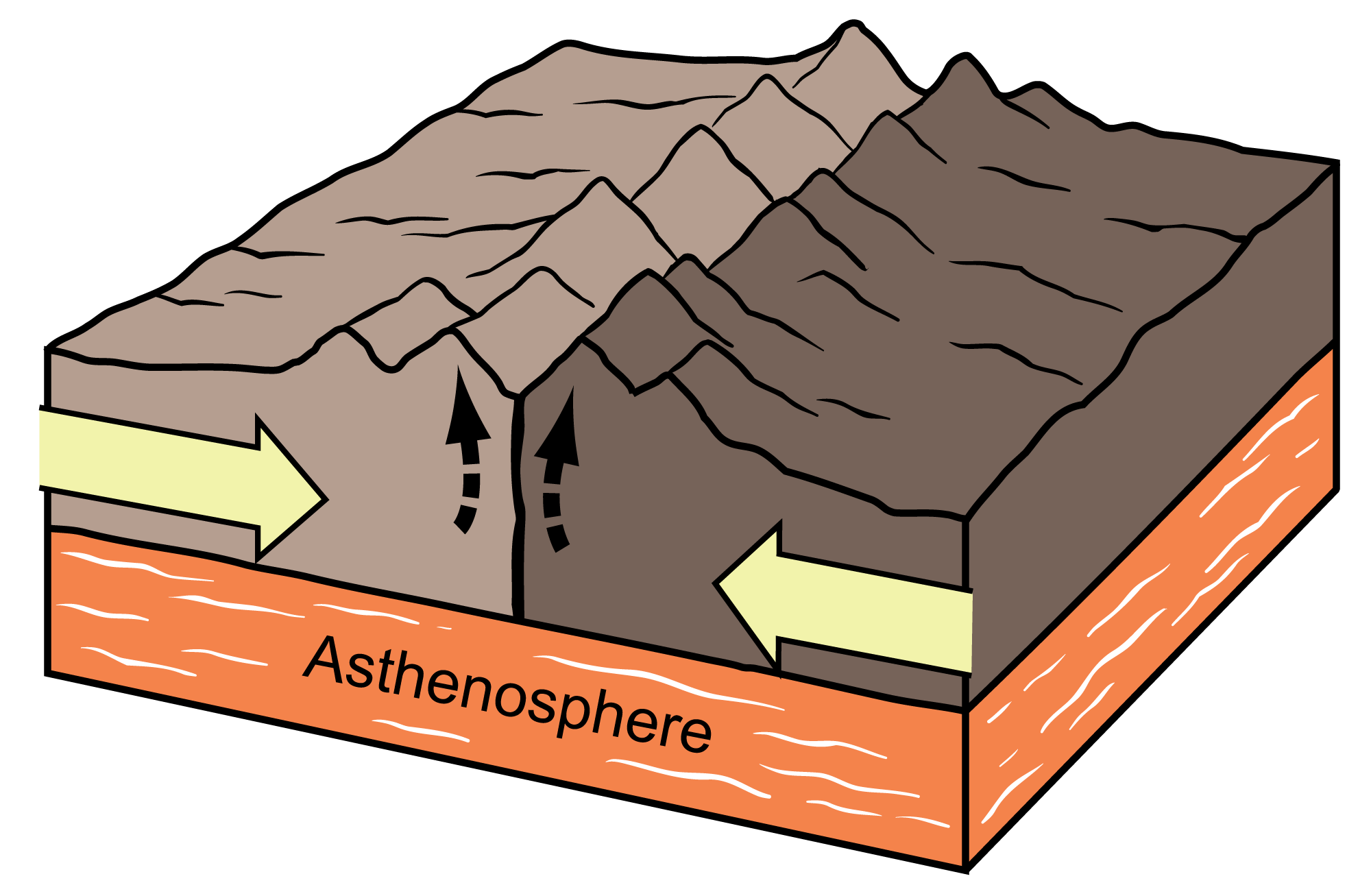
A convergent boundary at which two continents are colliding (the two continents are colored two shades of brown in the diagram). Image modified from original by Jim Houghton, first published in The Teacher-Friendly Guide to the Geology of the Southeastern U.S., 2nd ed., edited by Andrielle N. Swaby, Mark D. Lucas, and Robert M. Ross (published by the Paleontological Research Institution) (CC BY-NC-SA 4.0 license).
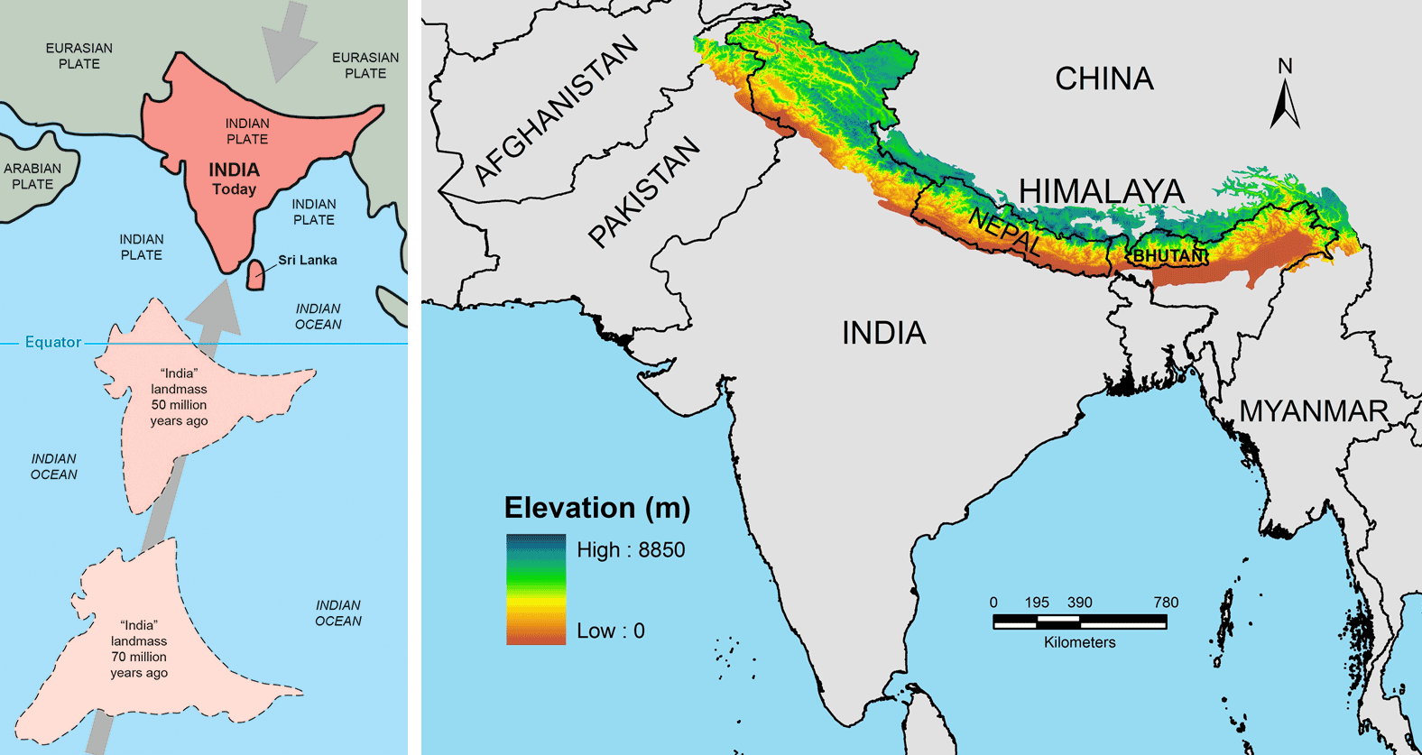
Left: The changing positions of the Indian subcontinent in the Late Cretaceous (70 million years ago), the Paleogene (50 million years ago) and today. Illustration from Kious and Tilling (1996) This Dynamic Earth: the Story of Plate Tectonics (USGS). Right: Map of the modern Himalayan Mountains in Asia. These mountains formed when the Indian subcontinent collided with Asia. Figure 1 from Manish and Pandit (2018) PeerJ 6:e5919 (Creative Commons Attribution 4.0 International license, image resized).
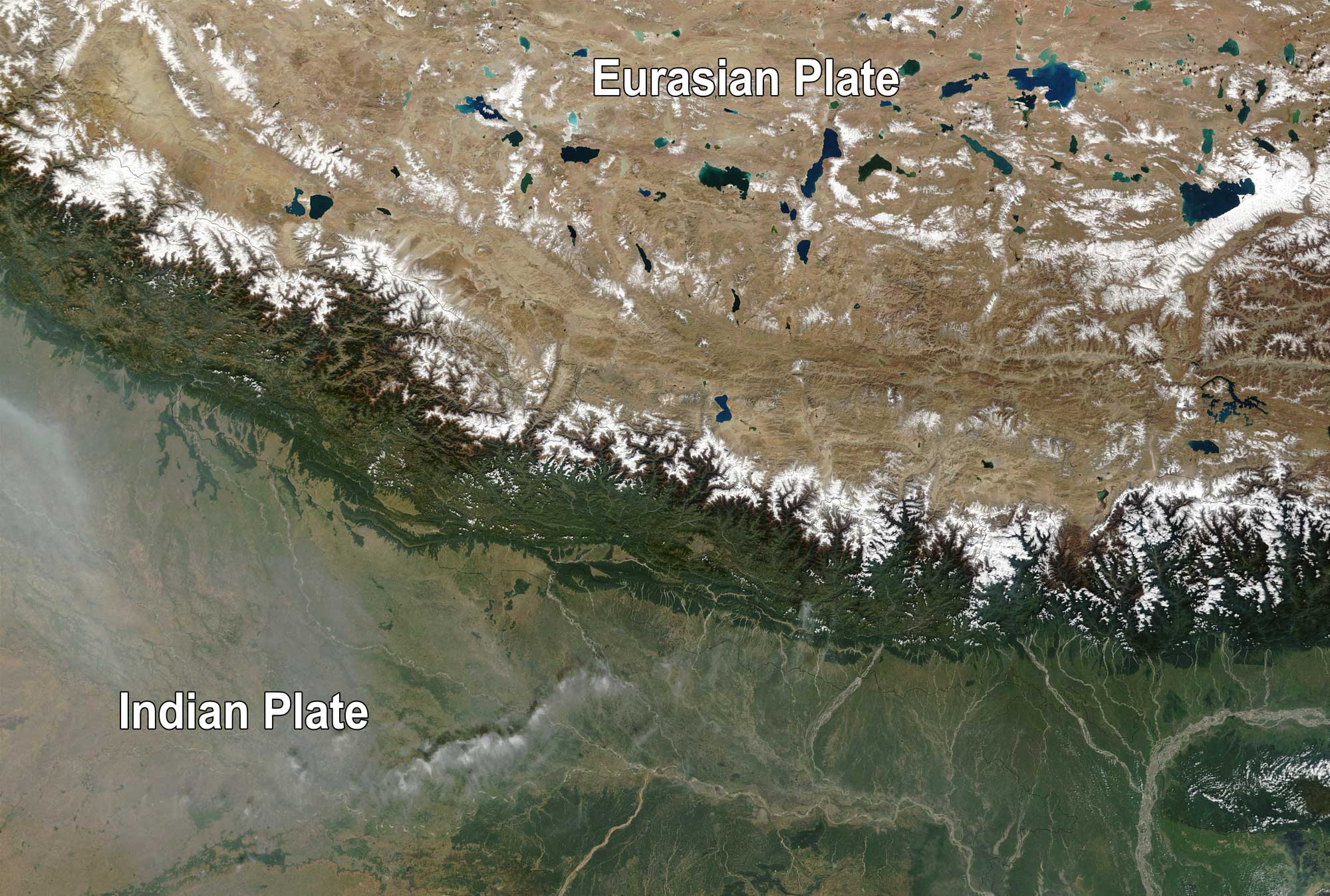
The Himalayan Mountains are at a convergent boundary were the Eurasian Plate is colliding with the Indian Plate. This satellite image shows the two plates and the mountains forming as they collide. Image modified from original by Jacques Descloitres, MODIS Rapid Response Team, NASA/GSFC (Nasa Visible Earth, used following image use policy).
Divergent boundaries
Divergent plate boundaries exist where tectonic plates are under tension; essentially, when plates are being pulled apart. This tension leads to the upwelling of magma, which forces its way through the separating crust onto the surface. In continental settings, the tension causes faulting and shallow earthquakes. As the faults pull apart and thin the crust, the decrease in overlying pressure can result in the formation of small volcanoes called cinder cones. In oceanic settings, new oceanic crust is created, and shallow, minor earthquakes occur.
Continental rifts
On a continent, a divergent boundary appears as a rift. A rift forms when a single plate begins to break apart, or when previously fused plates begin to separate again. When a rift occurs in continental crust, elongated fissures (faults) begin to form in the crust as it thins and stretches. Blocks of crust drop down between the faults, forming basins that fill with sediment. Magma rises up through the margins of the basins and may be extruded at the surface as lava flows.
A rifting continental crust will have characteristic long, roughly parallel valleys. Some of these may fill with water to form lakes. One of the most famous rift areas today occurs in East Africa. There, a large rift system formed by the stretching of the African plate has created a landscape with rift valleys and deep rift lakes, like Lake Tanganyika and Lake Malawi of the African Great Lakes region.
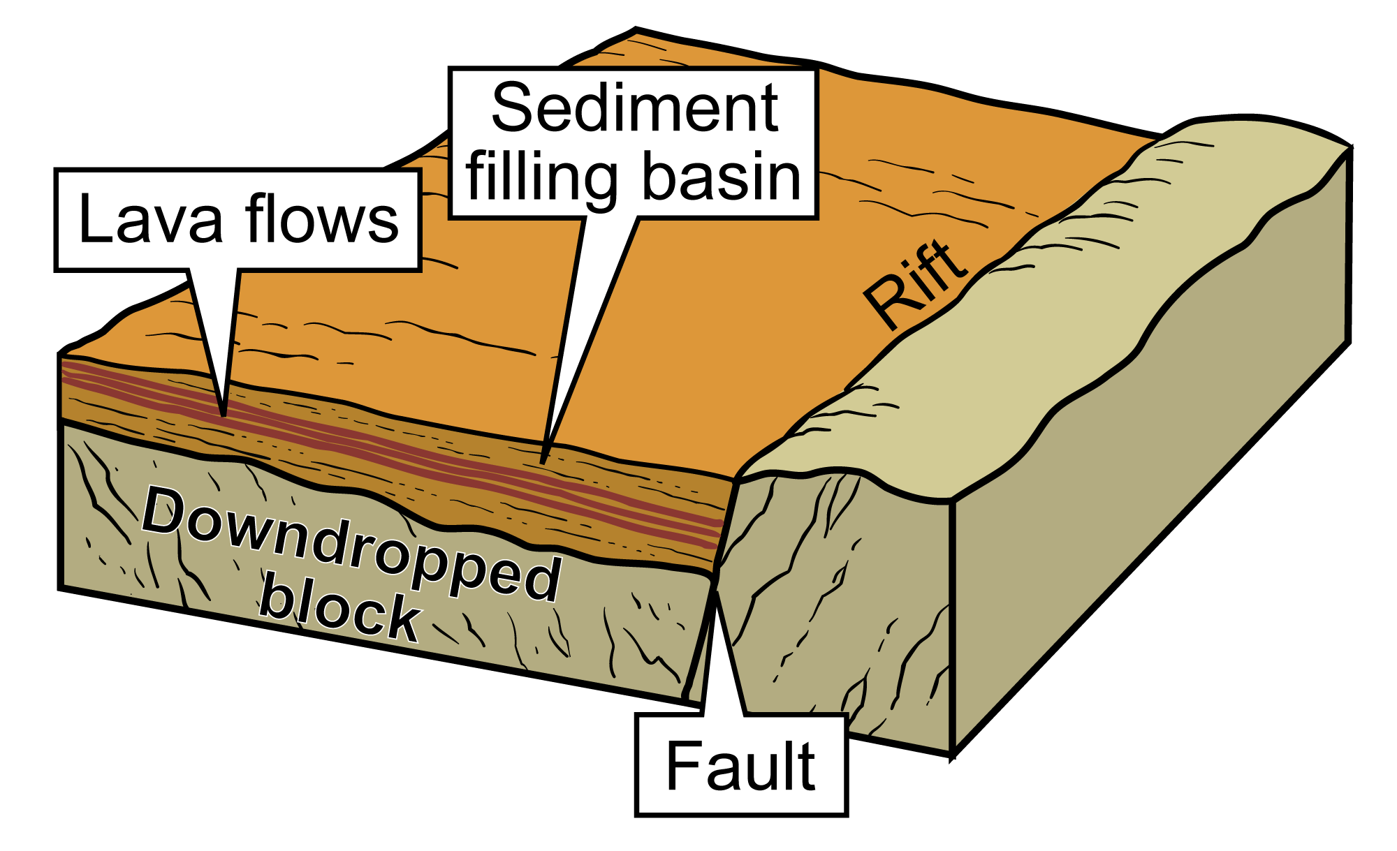
A typical rift basin. The fault is the break in the rock along which the downdropped block has slid, forming a depression known as a rift basin. Sediment begins to fill the basin as it erodes from the surrounding landscape. Magma in the form of lava flows may well up through cracks in the basin, creating layers of igneous rock (basalt). Image modified from original by Jim Houghton, first published in The Teacher-Friendly Guide to the Geology of the Southeastern U.S., 2nd ed., edited by Andrielle N. Swaby, Mark D. Lucas, and Robert M. Ross (published by the Paleontological Research Institution) (CC BY-NC-SA 4.0 license).
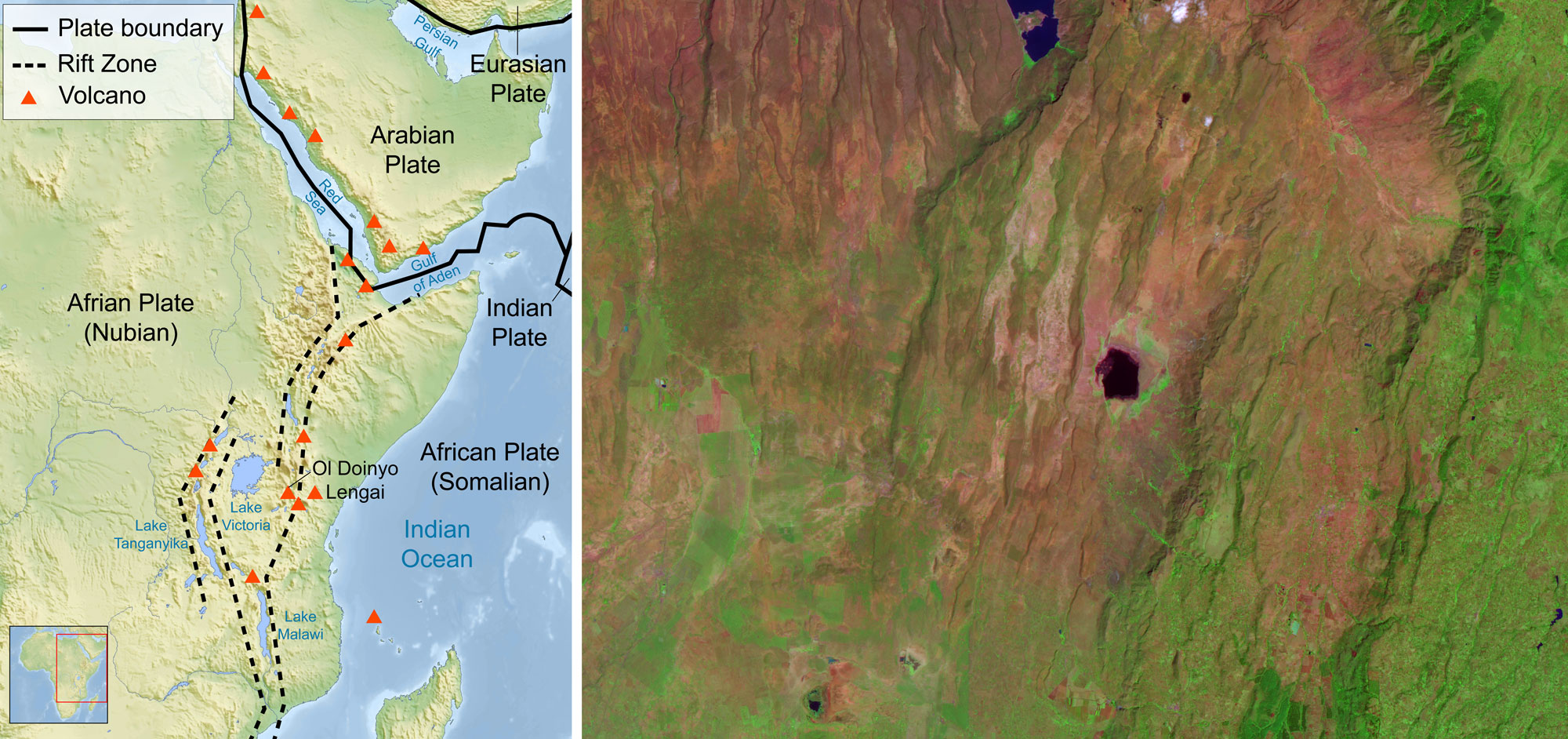
East African Rift Zone. Left: Map showing the East African Rift Zone (dotted lines), a rift zone formed by the slow breaking apart of the African plate. Map by Sémhur, modified by Furado (Wikimedia Commons, Creative Commons Attribution-Share Alike 3.0 Unported license, image modified). Right: Satellite view of the area to the south of Lake Bogoria (the bottom of the lake can be seen in the center top of the image), Rift Valley Province, Kenya. Note the parallel ridges and valleys formed by the rifting process. Source: NASA simulated nature color image created by Jesse Allen (NASA Earth Observatory, used following NASA's image use policy, image cropped and resized).
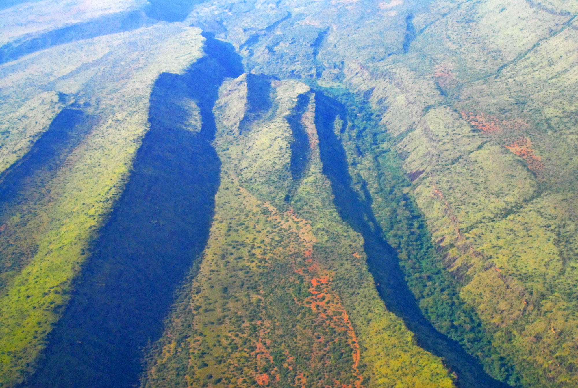
A rift valley in Kenya. Photo by Peter Prokosch (GRID-Arendal, used after terms of use).
Oceanic rifts
As rifting continues, the continental crust stretches and thins further and further until it eventually ruptures. The region where the crust breaks floods with water, forming a narrow sea. As the edges of the broken crust continue to separate, magma rises up through the margins of the rift, cooling to produce new dense, mafic oceanic crust. The submerged rift is now a spreading center on the seafloor. The continuing separation between the edges of the broken plate and formation of new oceanic crust continue to widen the sea slowly over time.
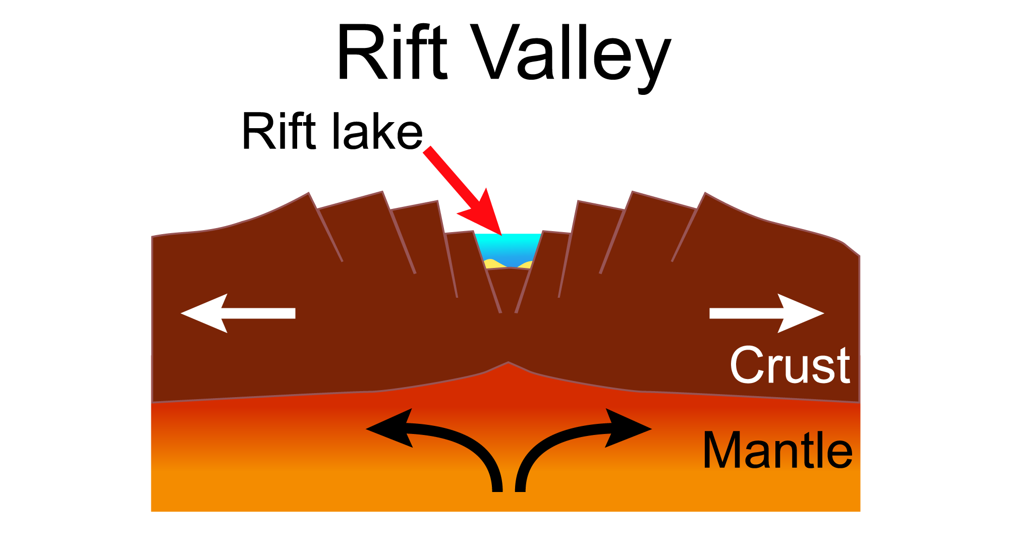
Formation of a rift valley. As the continent begins to separate, faults and basins form. The basins may fill with water to form rift lakes. Modified from a diagram by Hannes Grobe (Wikimedia Commons, Creative Commons Attribution-ShareAlike 2.5 Generic license).
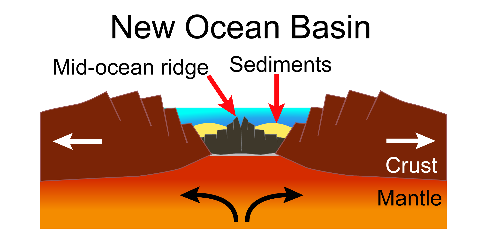
Formation of a new ocean basin. The continental crust has ruptured and the rift is now flooded with seawater. Oceanic crust begins to form in the new oceanic basin. Modified from a diagram by Hannes Grobe (Wikimedia Commons, Creative Commons Attribution-ShareAlike 2.5 Generic license).
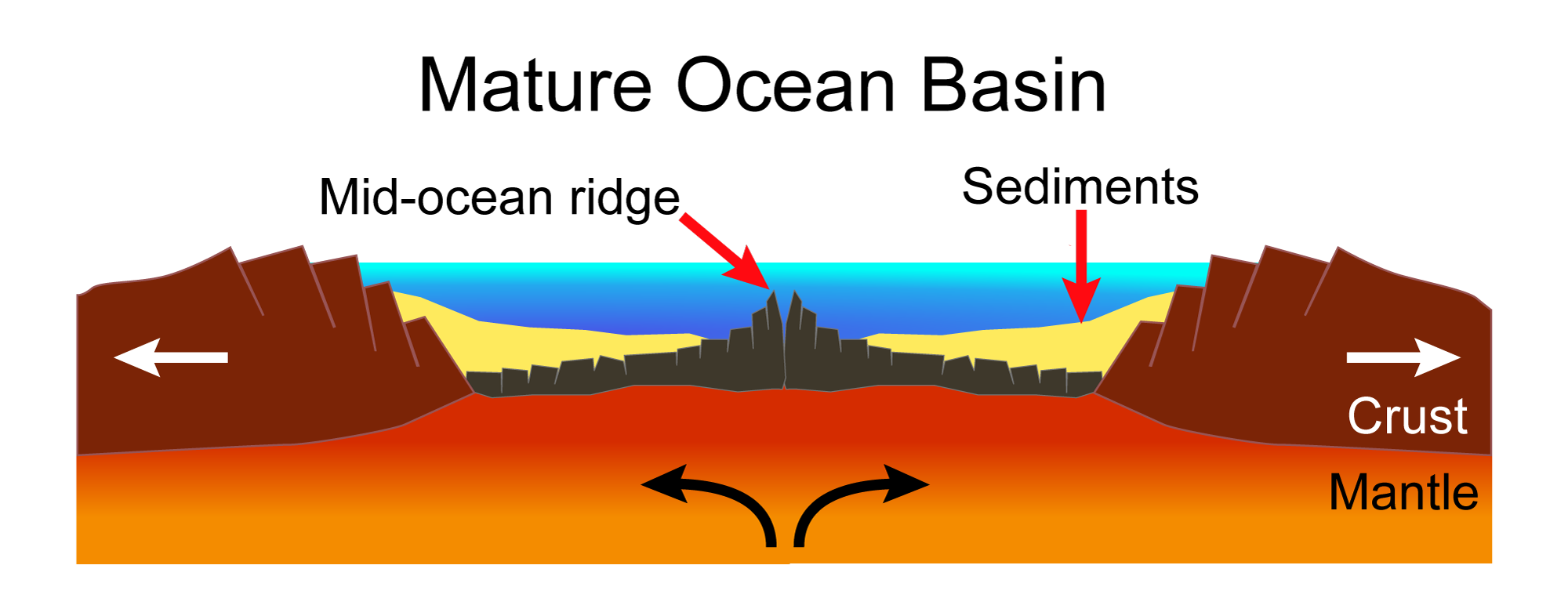
Mature ocean basin. As the pieces of the continent continue to separate, new oceanic crust is formed at a mid-ocean ridge. Modified from a diagram by Hannes Grobe (Wikimedia Commons, Creative Commons Attribution-ShareAlike 2.5 Generic license).
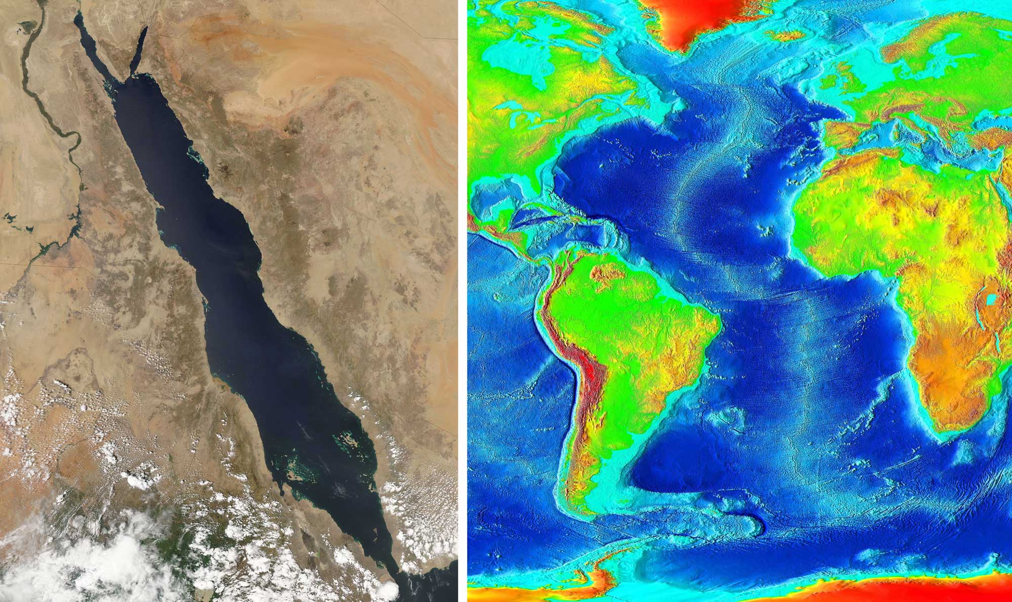
Left: The Red Sea between Africa (left) and the Arabian Peninsula (right) formed in a rifted basin. Photo by Jeff Schmaltz, MODIS Rapid Reponse Team, NASA/GSFC (used under NASA image use policy, image cropped and resized). Right: The Mid-Atlantic Ridge is a spreading center along which the continents on the western and eastern sides of the Atlantic are separating. The ridge is the light blue line running vertically through the Atlantic. Photo by NOAA (Wikimedia Commons, public domain).
Failed rifts
In some cases, a rift fails. A failed rift occurs when the existing crust is stretched thin and magma begins to well up, but the plate is never completely broken. An example of a failed rift is the Midcontinent Rift System (Keweenawan Rift), an ancient rift in the North American continent that extends in an arc from eastern Kansas to Minnesota, through lake Superior, and down into Michigan. This rift originated about 1.1 billion years ago and is thought to have formed over a hot spot in the Earth's mantle (read more below). Rifting may have stopped when the hot spot disappeared. Ancient igneous and sedimentary rocks are found in this failed rift zone.
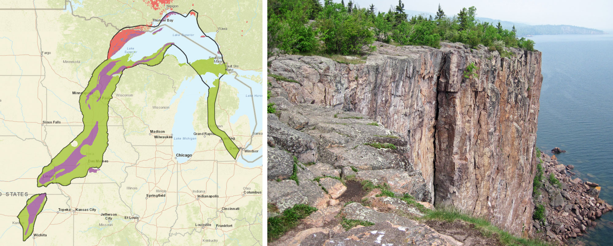
The Midcontinent Rift System. Left: Map showing the boundary of the Midcontinent Rift (black line) and the rocks types in it. Green = sedimentary rock; blue = metamorphic rock; purple = volcanic rock; pink = intrusive igneous rock. Map from USGS "Mineral Deposits of the Midcontinent Rift System." Right: Palisade rhyolite (an extrusive igneous or volcanic rock), about 1.1 billion years old, shore of Lake Superior, northeastern Minnesota. Photo by James St. John (flickr, Creative Commons Attribution 2.0 Generic license, image cropped and resized).
Transform boundaries
Transform boundaries exist where adjacent tectonic plates are moving alongside each other in opposite directions, causing a transform fault to develop. Most transform fault boundaries can be found in the ocean, where they connect segments of divergent boundaries.
One exception is the San Andreas Fault, which is mainly located on land. The San Andreas Fault produces earthquakes when the plates slip along side one another. It also creates ridges that run parallel to the fault. Mountains and valleys occur where the fault changes direction.
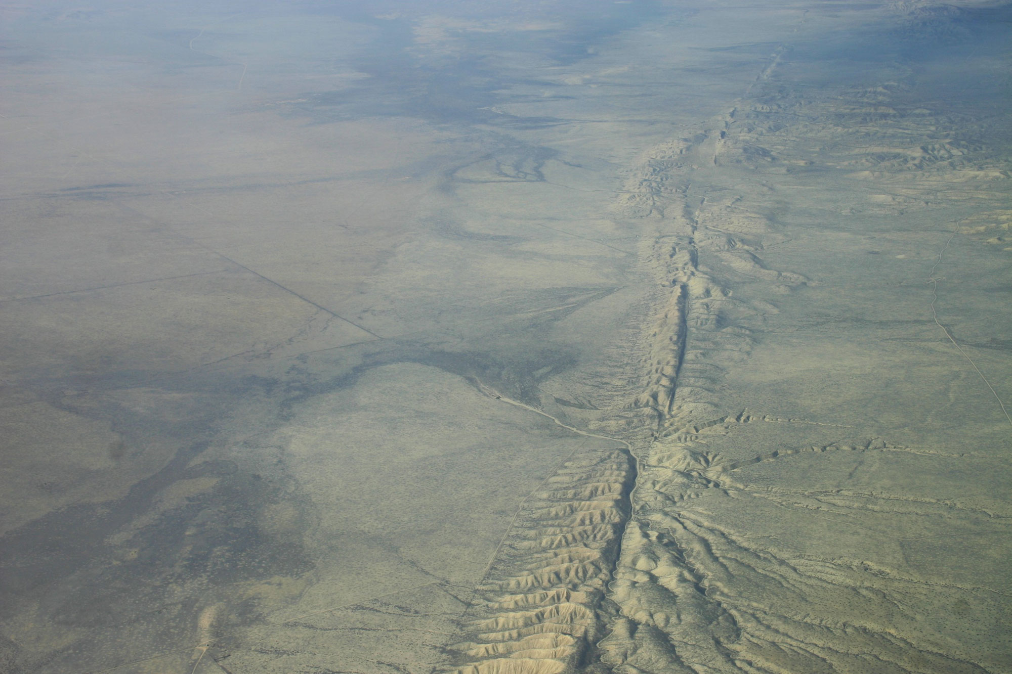
Aerial photo of the San Andreas Fault, Carrizo Plain, California. Photo by Ikluft (Wikimedia Commons, Creative Commons Attribution-ShareAlike 4.0 International license, image resized).
Hot spots
A hot spot is a volcanic region thought to be fed by a spot in the underlying mantle that is anomalously hot. In a hot spot, plumes of magma rise from the layer where the Earth's mantle and core meet. The hotter material rises because it is less dense and therefore more buoyant than its surroundings. The magma from the hot spot pushes its way up through the overlying crust, creating igneous intrusions (subsurface igneous rocks, like granite) and sometimes erupting from volcanoes on the surface as lava.
Hot spots can occur under both continental and oceanic crust, and they provide evidence that the Earth’s tectonic plates move. Since a hot spot is nearly stationary in the mantle, it remains in place as the plate slowly moves over it, forming a chain of volcanic features that increase in age as one moves away from the hot spot. Hot spots are sometimes associated with rifting because a hot spot may cause expansion and thinning of the overlying crust, making it susceptible to rupturing.
Hot spots in the U.S.
Two well-known hot spots occur in the United States: the Hawaiian Islands and Yellowstone National Park. The Hawaiian Islands have formed over a hot spot underneath the oceanic crust of the Pacific Plate. As the plate moves over the hot spot, new volcanoes are created, eventually erupting above the water's surface. Older islands that have moved away from the hot spot erode, eventually disappearing beneath the sea as they weather away. In fact, the Hawaiian Islands are part of a chain of seamounts (undersea mountains) that extends to the edge of the Aleutian Islands.
The geysers and other geothermal features at Yellowstone National Park are the result of a hot spot under the North American plate. The hotspot formed in the Miocene Epoch, about 16.5 million years ago. Volcanic rocks marking the location of the hotspot have been moving northeast as the North American gradually drifts.
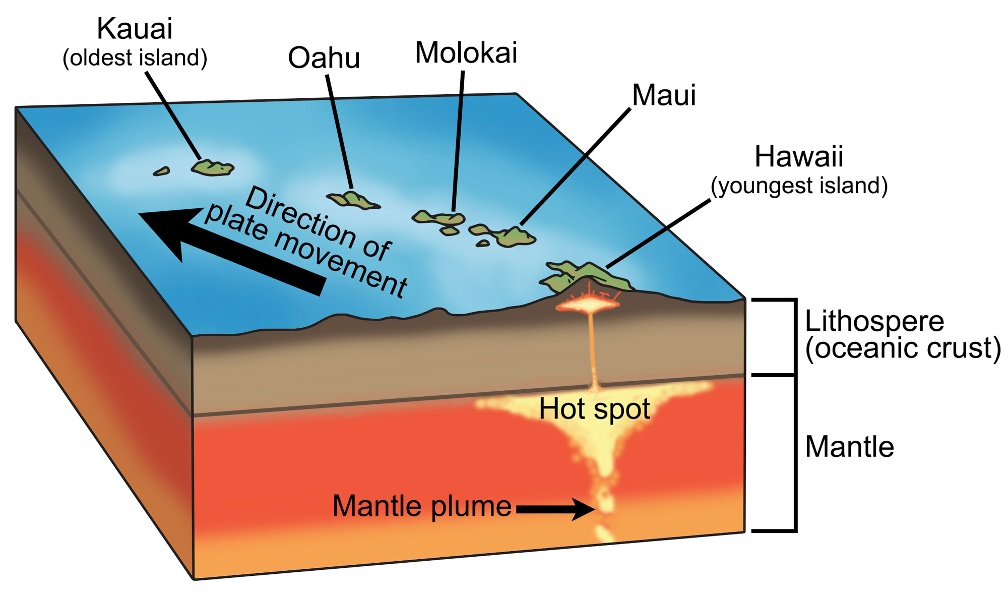
Diagram showing the hot spot beneath Hawaii. Magma rises up in a plume from the Earth's core, forming a magma in the upper mantle. The magma rises, causing volcanic activity on the surface. Hawaii is the youngest of the Hawaiian islands and active volcanism still occurs there. As the Pacific Plate continues to move, it will eventually be supplanted by another island. Modified from a diagram by Wade Greenberg-Brand (originally published in The Teacher-Friendly Guide to the Earth Sciences of the Western US, after a diagram by Tasa Graphic Arts, Inc.).
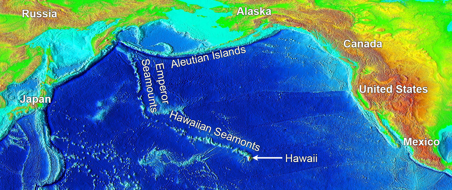
False-color image of the Pacific showing bathymetry and elevation. The Hawaiian Seamounts and the Emperor Seamounts are a continuous chain of islands and seamounts (volcanic mountains that are submerged) produced by a hot spot under the Pacific Plate. The seamount chain extends for 5800 kilometers (3600 miles), ending near the eastern end of the Aleutian Island chain, which was formed by subduction of the Pacific Plate. Image by National Geophysical Data Center/USGS (Wikimedia Commons, public domain).
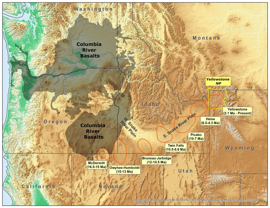
Original caption: "Map of the northwestern U.S., showing the approximate locations of Yellowstone hotspot volcanic fields (orange) and Columbia River Basalts (gray). Boundary of Yellowstone National Park is shown in yellow. Modified from Barry et al. (GSA Special Paper 497, p. 45-66, 2013), Smith and Siegel (Windows into the Earth: the geologic story of Yellowstone and Grand Teton National Parks: Oxford University Press, 2000), and Christiansen (USGS Professional Paper 729-G, 2001)." Source: USGS (public domain).
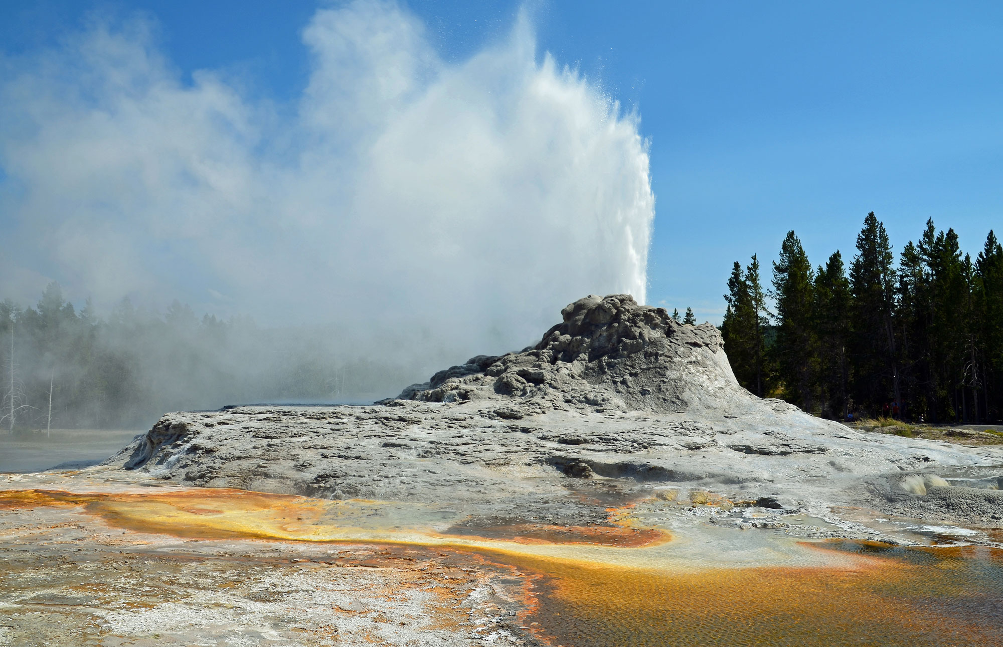
Castle geyser at Yellowstone National Park. Photo by Clément Bardot (Wikimedia Commons, Creative Commons Attribution-ShareAlike 3.0 Unported license, image resized).
Ancient Continents and Their Names
It has taken hundreds of millions of years for the continents to take on the shapes we see today. Ancient continents looked very different. To simplify descriptions of ancient geography, geologists have given names to earlier "proto-continents" to distinguish them from their modern counterparts. Proto-Europe (northwestern Europe without Ireland and Scotland) in the early Paleozoic is known as Baltica; proto-North America is known as Laurentia; and proto-Africa was part of a larger continent known as Gondwana, which included what are now Africa, Australia, Antarctica, India, and South America.
Pangaea
Pangaea (also spelled Pangea), meaning "all Earth," is one of the most famous ancient continents. Pangaea began to assemble over 300 million years ago and lasted for almost 150 million years. Pangaea was made up of all of the Earth's continents together and is considered a supercontinent.
How do we know that Pangaea existed 250 million years ago? Long before the discovery of plate tectonics in the 1960s and early 1970s, fossils and mountain belts provided evidence that the continents had not always been in their current positions. For example, the Permian-aged fossil plant Glossopteris had seeds too heavy to be blown across an ocean. Yet Glossopteris fossils are found in South America, Africa, Australia, India, and Antarctica. The mountain belts along the margins of eastern North America (the Appalachian and Ouachita Mountains), northwestern Africa (the Anti-Atlas Mountains), and Europe (Scottish Highlands) line up as well and have similar rock types, an indication that the continents at one time were joined.
Despite the discovery of Glossopteris and other geologic evidence, the theory of continental drift was not accepted for decades, until the mechanisms of continental movement were discovered and reformulated under the modern theory of plate tectonics. The supercontinent Pangaea existed for approximately 100 million years, reaching its largest size during the Triassic period. During the Jurassic, the landmass began to fragment. Gondwana was a smaller continent that was created when Panagaea began to break up into separate landmasses.
Geologic Time
The geologic time scale is an important tool used to portray the history of the Earth—a standard timeline used to describe the age of rocks and fossils, and the events that formed them. How did geologists come up with the timeline for the history of the Earth? The geologic time scale was developed over the course of many years—beginning in the early 19th century—and through the combined work of many geologists around the world.
No single location on Earth contains the complete sequence of rocks from Precambrian to present. Geology as a science grew as geologists studied individual stacks or sections of rock and connected them to each other. Gradually, successions of fossils were discovered that helped geologists determine the relative ages of groups of rocks. These layers could then be correlated with similarly aged rock units from around the world.
The names you see for the different periods on the geologic time scale have diverse origins; most are based on geographic areas where rocks of that age were first well studied. Time periods were named after dominant rock types, geography, mountain ranges, and even ancient tribes like the Silures of England and Wales, from which the "Silurian" period was derived.
Precambrian
The Precambrian spans Earth's entire history and is divided into four principal sections. The first of these four divisions, the Precambrian, extends from the beginning of the Earth, around 4.6 billion years ago, to the beginning of the Cambrian period, around 541 million years ago. The Precambrian is subdivided into three sections: the Hadean (about 4.6 to 4.0 billion yeas ago), the Archean (before 2.5 billion years ago) and the Proterozoic (2.5 billion to 541 million years ago). Less is known about the Earth during the Precambrian than during later parts of its history, since relatively few fossils or unaltered rocks have survived. Nevertheless, the evidence that has been preserved and discovered reveals much about the planet's first several billion years, including clear evidence that life first appeared on the planet some 3.9 billion years ago in the form of single-celled organisms.
Paleozoic
The second division, the Paleozoic, extends from 541 to 252 million years ago. Geological evidence shows that during this time period, continents moved, mountains formed, and life evolved in the oceans and gradually colonized the land. The Paleozoic is divided into six to seven time periods:
- Cambrian (about 541 to 485 million years ago): Complex animal life diversifies in the ocean during the "Cambrian Explosion."
- Ordovician
- Silurian
- Devonian (about X to X): Often called the "Age of Fishes." The time period during which amniote eggs and seeds evolved, vertebrates moved onto land, and the first forests appeared.
- Carboniferous (about X to X): Named for thick and abundant coal deposits. In North America, the Carboniferous is often divided into two periods, the Mississippian and the Pennsylvanian. The Mississippian is sometimes called "The Age of Crinoids" for its abundant crinoid fossils. The Pennsylvanian is known from extensive coal swamps and resultant coal deposits.
- Permian (about X to X): Named for a region of Russia. This time period is known for . The end-Permian extinction is the largest mass extinction to ever occur on Earth, wiping out nearly all species.
Mesozoic
The third division, the Mesozoic (from 252 to 66 million years ago), is also called the "Age of Dinosaurs" the "Age of Reptiles" since dinosaurs and other reptiles dominated both marine and terrestrial ecosystems. It is also noteworthy that during this time the last of the Earth's major supercontinents, Pangaea, formed and later broke up, producing the Earth's current geography. The Mesozoic is divided into three time periods:
- Triassic (X to X): The earliest dinosaurs appear.
- Jurassic (X to X): Some famous dinosaurs are known from this time period, including Stegosaurus.
- Cretaceous (X to X): Named for abundant chalk deposits. The world experienced a greenhouse (very warm) climate and sea levels were high; much of the center of North America was covered by a shallow sea during part of this period. Known for the appearance of flowering plants and North America's most famous predatory dinosaur, Tyrannosaurus rex. Ended with an asteroid impact in Mexico that caused a mass extinct on land and in the oceans.
Cenozoic
The last and current division, the Cenozoic, extends from the extinction of the dinosaurs, nearly 66 million years ago, to the present. With the demise of the dinosaurs, mammals became much more diverse and abundant. We humans didn't come into the picture until the last two million years. To get some perspective on this, if the entire geologic time scale were reduced to 24 hours, we wouldn't come onto the stage until two seconds before midnight!
The Precambrian U.S. (~4.6 billion to 541 million years ago)
The Precambrian is an interval of time that extends from the beginning of the Earth, around 4.6 billion years ago, to the beginning of the Cambrian period, around 541 million years ago. The Precambrian is subdivided into three parts: the Hadean (about 4.6 to 4 billion years ago), the Archean (about 4 to 2.5 billion years ago), and the Proterozoic (2.5 billion to 541 million years ago).
Less is known about the Earth during the Precambrian than during later parts of its history, since relatively few fossils or unaltered rocks have survived. Nevertheless, the evidence that has been preserved and discovered reveals much about the planet's first several billion years, including clear evidence that life first appeared on the planet some 3.9 billion years ago in the form of single-celled organisms.
Hadean, Archean, and Paleoproterozoic (~4.6 to 1.6 billion years ago)
The Earth is estimated to be approximately 4.6 billion years old, an age obtained by dating meteorites. Early in Earth's history, shields originated and grew during pulses of magmatic activity. A shield, or craton, is the stable core of a continent. Molten rock deep under the Earth's crust was extruded to the surface where it solidified, creating new crust. On the modern Earth, shields are often covered by layers of younger sediments.
The Canadian Shield is the craton of the North American continent. It includes much of Greenland and more than half of Canada. It extends south into the Adirondack Mountains of New York and the Superior Upland region of the Midwest.
The oldest rocks in North America are 4.3-billion-year-old rocks found along the eastern shore of Hudson Bay in northern Quebec. Most of the Canadian shield is an accumulation of smaller plates and terranes that formed over a period of hundreds of millions of years, between 2.5 and 1.25 billion years ago. The shield was the first section of the North American continent to emerge above sea level, and it remains the largest exposure of Precambrian-aged rock in the world.
Laurentia and other landmasses may have joined to form a supercontinent known as either Nuna or Columbia in the Paleoproterozoic to Mesoproterozoic. However, the evidence for the existence of this supercontinent is not as strong as the evidence for the later supercontinents of Rodinia and Pangaea. It is hypothesized that Nuna began to fragment after about 1.4 billion years ago, in a process that lasted for several hundred million years.
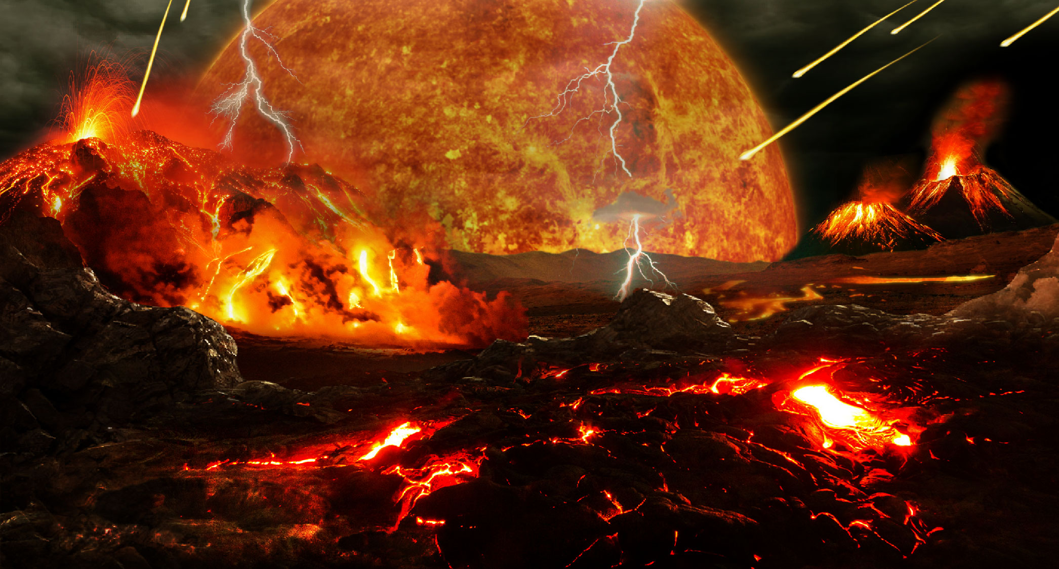
Artistic reconstruction of Earth during the Hadean. Image by Tim Bertelink (Wikimedia Commons, Creative Commons Attribution-ShareAlike 4.0 International license).
Mesoproterozoic to Neoproterozoic (1.6 billion to 541 million years ago)
Rodinia Supercontinent (1.4 to 900 billion years ago)
The Grenville Orogeny occurred between about 1.3 and 1 billion and years ago. During the Grenville Orogeny, a number of smaller continental blocks and offshore islands were added to the much older core of Laurentia. The collisions between Laurentia and these smaller landmasses caused mountains to form. They created a tall (perhaps Himalaya-scale) mountain range, the Grenville Mountains, which stretched from Canada to Mexico. The the Grenville Belt on the present-day eastern margin of North America consists of rocks formed from sediment deposited in the ocean waters during this time.
The Grenville Orogeny was one of several Precambrian continental collisions that led to the assembly of the supercontinent Rodinia, which formed between 1.4 billion and 900 million years ago. Rodinia contained most or all of Earth's landmass.
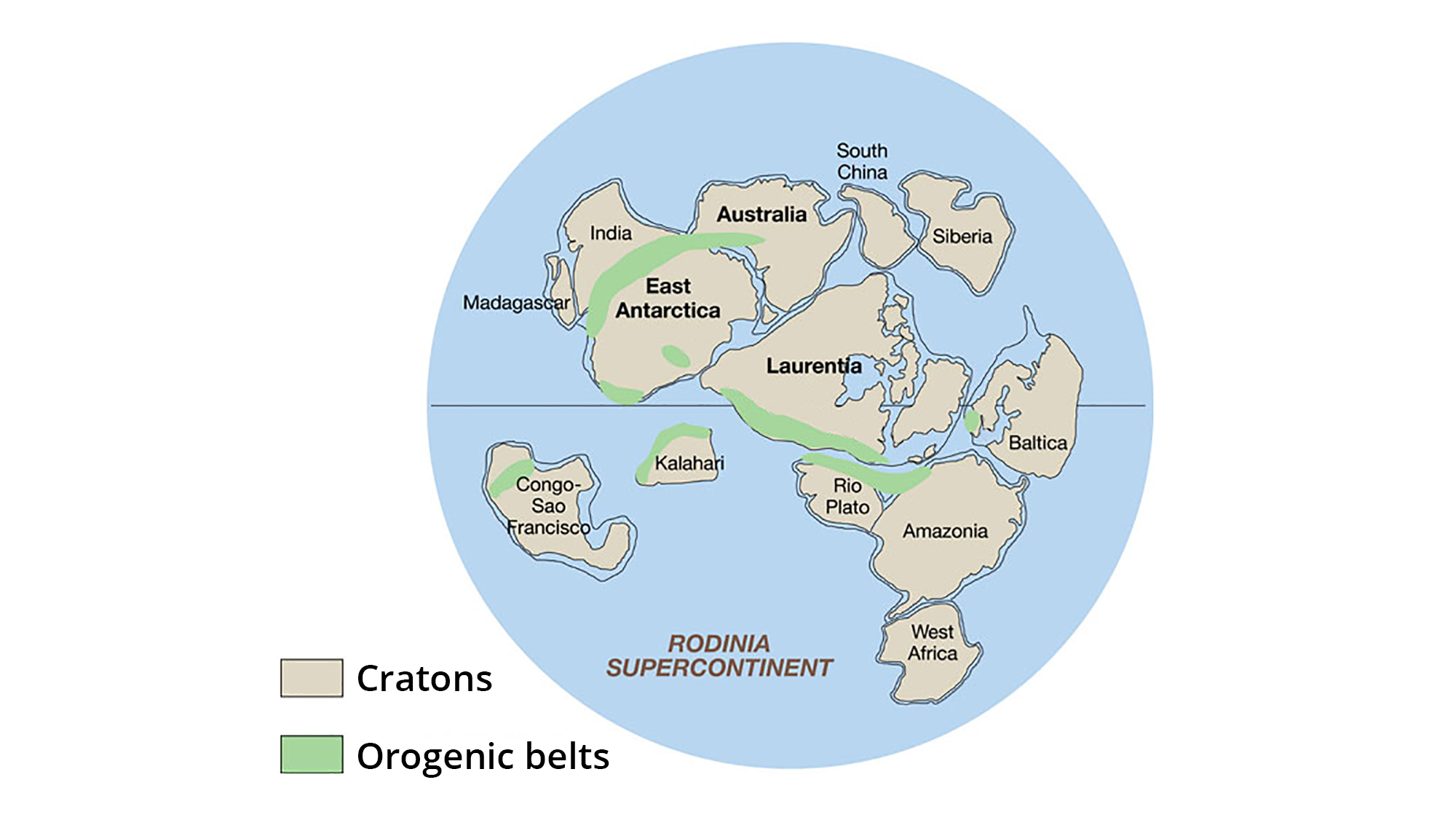
The supercontinent Rodinia, around 1.1 billion years ago. Laurentia represents proto-North America. Note that what is eastern North America today is on the southern margin of Laurentia, and that today's eastern North America is near the equator. Orogenic belts are regions where mountain-building is occurring, whereas cratons are stable, tectonically quiet regions. Image adapted from original created by John Goodge for the United States Geological Survey (public domain).
Breakup of Rodinia (700 to 565 million years ago)
Laurentia began to break away from the rest of Rodinia about 700 million years ago. The breakup was caused by rifting. During this time, Earth experienced the most extreme episodes of glaciation in its history. Ice sheets spread all the way into tropical latitudes.
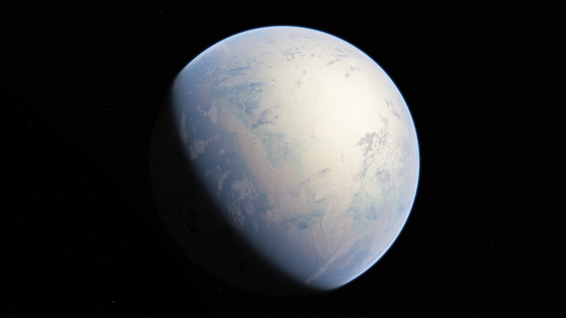
An artistic reconstruction of Earth during the Huronian Glaciation. Image by Oleg Kuznetsov (Wikimedia Commons, Creative Commons Attribution-ShareAlike 4.0 International license).
Around 565 million years ago, the continents that made up Rodinia split apart completely along a major rift. The rift that caused the breakup of Rodinia flooded and transformed from continental to oceanic (basaltic) crust. The depression in the rifted area filled with seawater, forming the Iapetus Ocean.
Near the end of the Precambrian, Laurentia was positioned near the equator. The continent was rotated roughly 90° clockwise relative to its current position, so that the present-day eastern margin of North America was facing south. As the young Iapetus Ocean widened, global sea levels also rose. Much of Laurentia's interior flooded with seawater, forming shallow epicontinental seas.
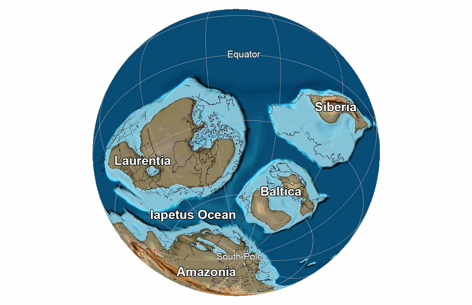
Earth at the end of the Precambrian, 565 million years ago. Laurentia is the name given to "proto-North America"; Baltica consists of modern northern European countries; Amazonia, which was part of Gondwana, includes much of modern Brazil. All of these continents were positioned south of the equator 565 million years ago. Reconstruction created using basemap from the PALEOMAP PaleoAtlas for GPlates and the PaleoData Plotter Program, PALEOMAP Project by C. R. Scotese (2016); map annotations by Jonathan R. Hendricks for PRI's Earth@Home project (CC BY-NC-SA 4.0 license).
The Paleozoic U.S. (541 to 252 million years ago)
The Paleozoic Era extends from 541 to 252 million years ago. Geological evidence shows that during this time period, continents moved, mountains formed, and life evolved in the oceans and gradually colonized the land. Much of the tectonic activity during the Paleozoic Era is concentrated on the present-day eastern margin of North America (at the beginning of the Cambrian, the continent was rotated clockwise 90 degrees, so this was the southern margin of Laurentia).
Cambrian to Ordovician (541 to 444 million years ago)
Around 500 million years ago, the Iapetus Ocean stopped widening and the continents began to move back toward each other. During the Taconic Orogeny (490 to 460 million years ago), a volcanic island arc collided with Laurentia. This series of collisions added small landmasses to the present-day eastern margin of North America and formed mountains. Inland, downwarping of the continental crust formed basins that were flooded with seawater. These basin covered parts of the northeastern, southeastern, and midwestern United States. Sediment accumulated in these basins, preserving fossils of marine organisms.
At the start of the Paleozoic, the area that now comprises the states of California, Oregon, Washington, and western Nevada did not yet exist as part of the North American continent. In the early Paleozoic, about 500 million years ago, what is now the west coast of North America was a passive margin like the East Coast is today. Little or no volcanic activity, earthquakes, large mountain ranges, or plate boundaries were found in the Western States at that time.
Silurian to Mississippi (444 to 323 million years ago)
Eastern U.S.
From about 430 to 345 million years ago, Baltica (proto-Europe) collided with the eastern margin of Laurentia (modern-day Greenland). In addition, other small landmasses that had broken off the southern continent of Gondwana fused to Lauretia in the region of present-day northeastern North America. This series of collisions is known as the Acadian Orogeny.
The combined Baltica-Laurentia continent is called Laurussia. Laurussia was separated from the southern continent of Gondwana (Africa, Antarctica, Australia, India, and South America) by the Rheic Ocean. The Siberian landmass (a portion of present-day Asia) was to the north.
As the Earth’s continents began moving towards one another to eventually form the supercontinent Pangaea, the western states became an active subduction zone, uplifting new mountains. Subduction also led to accretion, adding volcanic islands and seafloor sediment to the edge of the continent. By 400 million years ago, large mountain ranges had risen in parts of Alaska and the Basin and Range region of Nevada and Oregon.
Southwestern U.S.
In the late Devonian period (approximately 370 million years ago) a major geological change took place in the southwestern U.S. A portion of the continental shelf adjacent to present-day Idaho and Nevada changed from a passive margin to an active subduction zone. Oceanic crust plunged beneath the continent.
As oceanic crust descended deep into the upper mantle, the rock above the descending crust melted to form a line of volcanoes on the surface. Subduction also led to accretion. Sediment, sedimentary rock, and even bits of the oceanic crust itself were scraped off the descending crustal plate and pushed onto the overlying plate. The collision between the plates caused the rocks to wrinkled up, forming mountains. Volcanic islands carried along by the subducting plate also accreted to the edge of the continent. Laurentia began to rotate counterclockwise, moving the North American plate into a more modern orientation. These collisions deformed and elevated the continent’s topography, generating two major mountain-building events: the Antler Orogeny (340 million years ago) and the Sonoman Orogeny (245 million years ago).
Pennsylvanian to Permian (323 to 252 million years ago)
From about 300 to 250 million years ago, the Rheic Ocean narrowed and the major continental landmasses on earth fused to form the supercontinent of Pangaea. The collision between Laurussia and Gondwana formed a long chain of mountains called the Central Pangean Mountains. This mountain range included the Appalachian Mountains of present-day eastern North America, the Ouachita Mountains of Arkansas and Oklahoma, and mountains found today on other continents, like the Anti-Atlas Mountains in northwestern Africa. At their highest, the Central Pangean Mountains may have been as tall and rugged as the Himalayan Mountains of Asia are today.
During the Pennsylvanian (300 million years ago), compressional forces from the collision and tension from coastal subduction combined to deform the continent’s interior, buckling the crust and creating deep basins between uplifted blocks. Shallow inland seas spread across the interior of the continent, covering parts of North America’s Precambrian shield. Uplift formed a mountain range, known as the Ancestral Rocky Mountains, in Wyoming, Colorado, and New Mexico, and land was also raised above sea level in Canada, Montana, and the Dakotas. Sediments that eroded from this range and other uplifted areas were transported to the inland sea and the continental margins, forming deposits of conglomerates, sandstones, shales, limestones, and evaporite minerals.
By the Permian, the assembly of Pangaea was essentially complete. The arrangement of most of the land into a supercontinent caused sea level to fall. When the continental plates are amassed, they take up a smaller area on the surface of the Earth, and oceanic crust takes up a greater area. This means there are likely to be fewer rifts on Earth’s surface, and therefore fewer midoceanic ridges (underwater mountain ranges that can displace huge volumes of water). Because in this arrangement there is, on average, more distance for oceanic crust to cover before it subducts below a continent, it spends more of its time on the surface, allowing it to cool, condense, and sink. Therefore, overall, the seafloor is “lower,” and the sea level is subsequently lower near the continental margins. As the Permian came to an end, the south-central U.S. transitioned to a terrestrial environment—in Texas, rocks from this time include salt and gypsum that were deposited as the sea retreated.
During this time, global sea levels began to fluctuate and ultimately fall. Regression of the sea (meaning, falling sea level) was caused by a combination of glaciation at the South Pole and the forces of mountain building. In present-day eastern North America, the sea that had been covering a portion of the continent retreated and vast coal swamps formed. Coal swamp deposits are particularly rich in Pennsylvanian time.
The Mesozoic U.S. (252 to 66 million years ago)
The Mesozoic era is frequently known as the Age of the Dinosaurs, but many other life forms evolved and thrived during this time, including marine invertebrates, flowering plants, birds, and mammals. The Mesozoic was also a time of major geologic change during which great thicknesses of rocks were deposited across the southwestern U.S. The supercontinent Pangaea was in place by the end of the Permian period, and global sea level was probably at its lowest of any time during the past 600 million years.
Triassic
Subduction along the western margin of the Americas generated the Cordilleran volcanic arc, which was active throughout much of the Mesozoic. Triassic rocks of the Grand Canyon record an influx of volcanic material from the adjacent arc, as well as sediment from adjacent highlands composed of sedimentary and plutonic rocks. Rocks from the Cordilleran arc are still present today in the Andes, Central America, the Cascades, and the Aleutians.
Jurassic
Pangaea began to break up during the early Jurassic, and sea levels began to rise again. By the middle Jurassic, a shallow arm of the sea reached from Canada south through Montana and parts of Wyoming, Utah, and the Dakotas, depositing thin layers of limestone, mudstone, and sand. During the Jurassic, mudstone and sandstones were also deposited in lowland areas and river channels throughout the Rockies and Colorado Plateau; these formed the Morrison Formation, which is famous for its abundant dinosaur fossils.
Cretaceous
During the Cretaceous, Pangaea entered its final stages of breakup. Far to the west, oceanic crust (the Farallon plate) had been subducting under western North America for tens of millions of years, causing a series of volcanic island complexes to collide with and become accreted to that margin of the continent. As oceanic crust was subducted beneath the continent, a new volcanic arc formed the Sierra Nevada of California.
The new Atlantic Ocean widened, and sea levels began to rise. The Farallon plate began to subduct at an unusually shallow angle, sliding farther inland beneath western North America before finally sinking into the asthenosphere. This downwarped the center of North America and created a basin that allowed the waters of the Gulf of Mexico to meet with those in the north, forming the Western Interior Seaway. This shallow inland sea inundated a 1000-kilometer (620-mile) wide swath from Mexico to Alaska, separating North America into an Appalachian island to the east and a mountainous Cordilleran island to the west.
Because the North American plate was (and still is) drifting away from the Mid-Atlantic Ridge during the Cenozoic, mountain building along the plate’s eastern margin ceased. Instead, sediment eroding from existing mountains was gradually deposited along North America’s passive continental margin. Despite minimal tectonic activity in the Coastal Plain area throughout the last 140 million years, the face of the land continued to change significantly due to erosion, deposition, sea level fluctuations, and the ice age.
Erosion from these western mountains resulted in deposition of thick layers of sediment throughout the seaway. During the very latest stages of the Cretaceous period, around 70 million years ago, the Western Interior Seaway was displaced by slow uplift of the continent. The Farallon plate continued to collide with western North America, thrusting layers of rock up over each other and causing increasing volcanism to the west of the Western Interior Seaway. The compressional forces of subduction faulted the crustal rocks of western North America and uplifted the Rocky Mountains in two major pulses. Nevadan Orogeny The Sevier Orogeny (100–72 million years ago) formed an extensive belt of and folds, also known as the “Overthrust Belt,” extending from the Sierra Nevada in California to the edge of the Colorado Plateau in western Utah. The second event, the Laramide Orogeny, peaked around 68– 65 million years ago when the angle of the subducting plate became shallower. This formed mountains farther inland than would normally be expected above a subduction zone, uplifting the Rocky Mountains in Wyoming, Colorado, and New Mexico.
Cretaceous-Paleogene boundary (66 million years ago)
The Cretaceous–Paleogene boundary marks one of the most significant physical and biological events in Earth’s history. The boundary, which is about 66 million years old, marks the contact between the Mesozoic and Cenozoic eras. It represents a time during which many marine and terrestrial animals and plants, from microscopic varieties to massive dinosaurs, suddenly became extinct. Many scientists accept that the Cretaceous extinctions resulted from the impact of a large meteorite that produced the Chicxulub impact crater along the northern coast of Mexico’s Yucatan Peninsula. The extinctions may also have been coupled with the regression of shallow seas and massive volcanism in India.
The boundary itself is rarely preserved in the geologic record, due to incomplete sedimentation and widespread erosion. However, there are several southwestern localities, especially in northern New Mexico and southern Colorado that preserve the K-Pg boundary layer.
The Cenozoic U.S. (66 million years ago to present)
The Cenozoic era (consisting of the Paleogene, Neogene, and Quaternary periods, 66 million years ago to present) was an age of diversification and evolution of mammals, birds, insects, flowering plants, and coral reefs. The continents continued to spread apart to reach their present-day positions. Sea levels rose and fell, affecting the coastlines. In the east, the North American plate continued drifting away from the Mid-Atlantic Ridge. Sediment eroded from existing mountains was gradually deposited along North America’s passive continental margin. The interior of North America remained relatively high and sediment deposition in that region occurred, for the most part, as fluvial and lake deposits. The Cenozoic geology of western North America was active and dominated by erosion, subduction and extension, and volcanic activity.
Paleogene
Subduction at the West Coast was progressively replaced to the north and south by the developing San Andreas fault system. Subduction continues today beneath Oregon and Washington (and beneath Mexico south of the Gulf of California).
Between 40 and 30 million years ago, a transition from subduction and crustal compression to crustal extension began to occur in the western U.S. Due to the complex interplay of plate motions, the portion of the subducting plate beneath the southwestern U.S. overrode hot, upwelling mantle. Melting of the lower crust resulted in the intrusion of numerous granitic bodies and the formation of large volcanic fields during the late Eocene to early Miocene. These include the San Juan and Thirty-nine Mile in Colorado and the Marysvale in Utah.
Beginning about 30 million years ago, a mid-ocean ridge called the East Pacific Rise collided with the North American continent. As this ridge subducted, the plate boundary adjacent to California gradually changed, becoming a transform or sideways-moving boundary. As a result, subduction ceased, as did the last of the volcanic activity in what we now know as the Sierra Nevada in eastern California and western Nevada. An important byproduct of this change in plate motion was that Nevada and southern Oregon began to pull apart, forming the collection of north-south trending mountains and valleys known as the Basin and Range.
Neogene
By the Neogene, the Farallon plate lay shallowly under the North American plate for hundreds of kilometers eastward of the West Coast. Now situated more fully beneath what are now the south-central, southwestern, and northwest-central states, this extra layer of crust caused uplift and extension of the region, as the added thickness of buoyant rock (relative to the mantle) caused the entire area to rise isostatically. The Farallon plate was subjected to increasing temperatures as it subducted, causing it to expand. As heat dissipated to the overlying North American plate, that rock expanded as well. Finally, the high temperatures in the upper mantle caused the Farallon plate to melt, and the resulting magma was injected into the North American plate, destabilizing it. These processes, along with the complex crustal movements taking place along the San Andreas fault, caused the surface of the North American plate to pull apart and fault into the mountainous blocks of the huge Basin and Range province that stretches from Idaho, Nevada, and Utah into California, Arizona, New Mexico, and Texas.
In the late Miocene, around eight million years ago, epeirogenic uplift (resulting from upwelling mantle heat pushing the crust upwards) began. The uplift raised the Rocky Mountains and Colorado Plateau to their current “mile-high” elevation. The modern direction of the Colorado River’s flow toward the Gulf of California was established about six million years ago, initiating the downcutting of the Grand Canyon in Arizona.
Quaternary
At the start of the Quaternary period, about 2.5 million years ago, continental ice sheets began to form in northernmost Canada. Throughout this period, the northern half of North America has been periodically covered by continental glaciers that originated in northern Canada (Figure 1.15). The Quaternary period is divided into two epochs: the Pleistocene and Holocene. During the Pleistocene, ice sheets advanced south and retreated north several dozen times, reaching their maximum extent most recently 25,000–18,000 years ago. The Holocene epoch is the most recent (and current) period of retreat, and is referred to as an interglacial interval. The beginning of the Holocene is considered to be 11,700 years ago, or about 9700 BCE.
The entire United States was affected by the cooling climate during the most recent ice age. A cooling climate contributes to the growth of continental glaciers: as more snow falls in the winter than melts in the summer, the snowpacks into dense glacial ice. In this case, as snow and ice continued to accumulate on the glacier, the ice began to move under its own weight and pressure. The older ice on the bottom was pushed out horizontally by the weight of the overlying younger ice and snow. Glacial ice then radiated out from a central point, flowing laterally in every direction away from the origin.
As a result, the continental glacier that originated in Canada migrated southwards toward the United States. During this time, the Laurentide Ice Sheet reached into Montana, the Dakotas, Nebraska, Kansas, and east into the Great Lakes region. The Cordilleran Ice Sheet reached into Washington, Idaho, and western Montana. Alpine glaciers covered the mountain heights in Idaho, Montana, Wyoming, Utah, Colorado, and New Mexico, as well as the Cascades and Sierra Nevada in the western states.
The ice age continues today, but the Earth is in an interglacial stage, since the ice sheets have retreated for now. The current interglacial period has slowed both erosional and depositional processes in the South Central—this and a higher, more stable sea level allowed coastal features such as barrier islands and lagoons to form, resulting in the landscape we know today. The glacial-interglacial cycling of ice ages indicates that the world will return to a glacial stage in the future, that is unless the impacts of human-induced climate change radically shift these natural cycles.