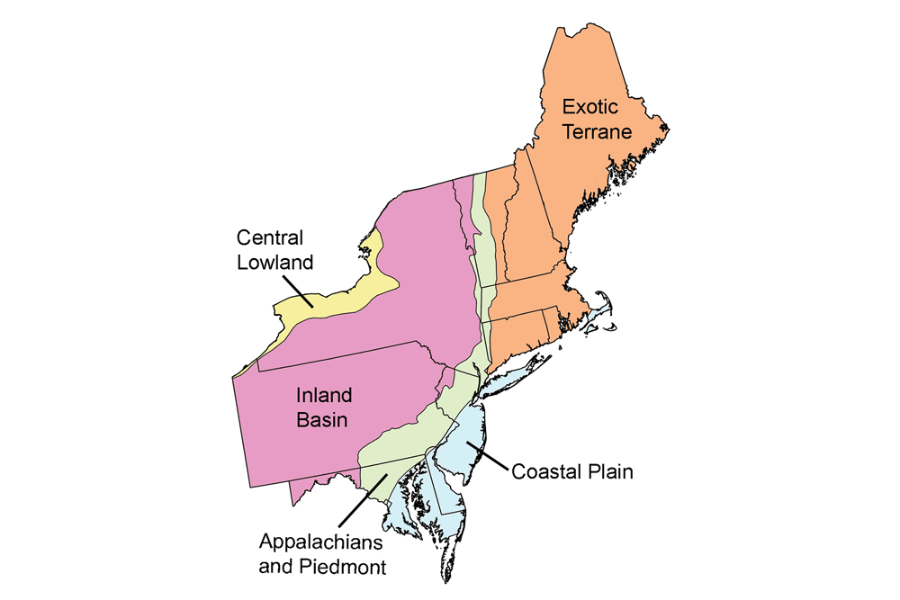
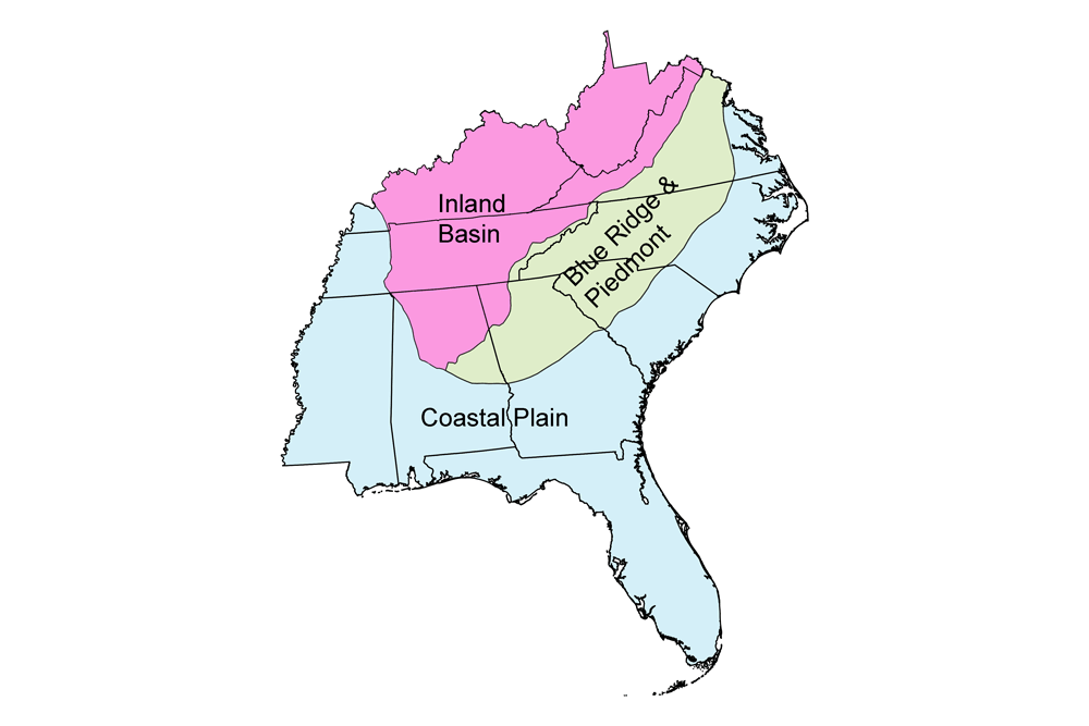
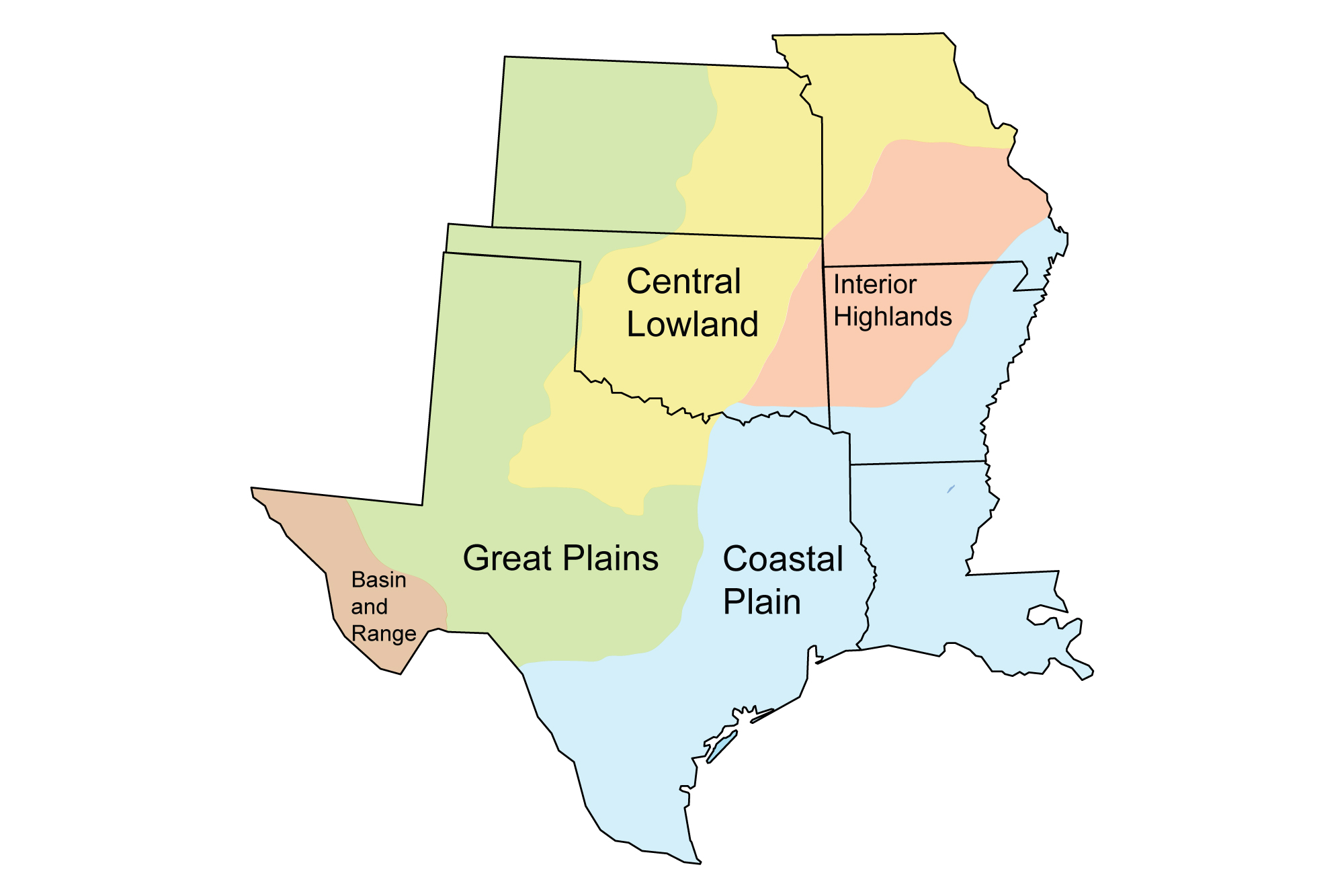
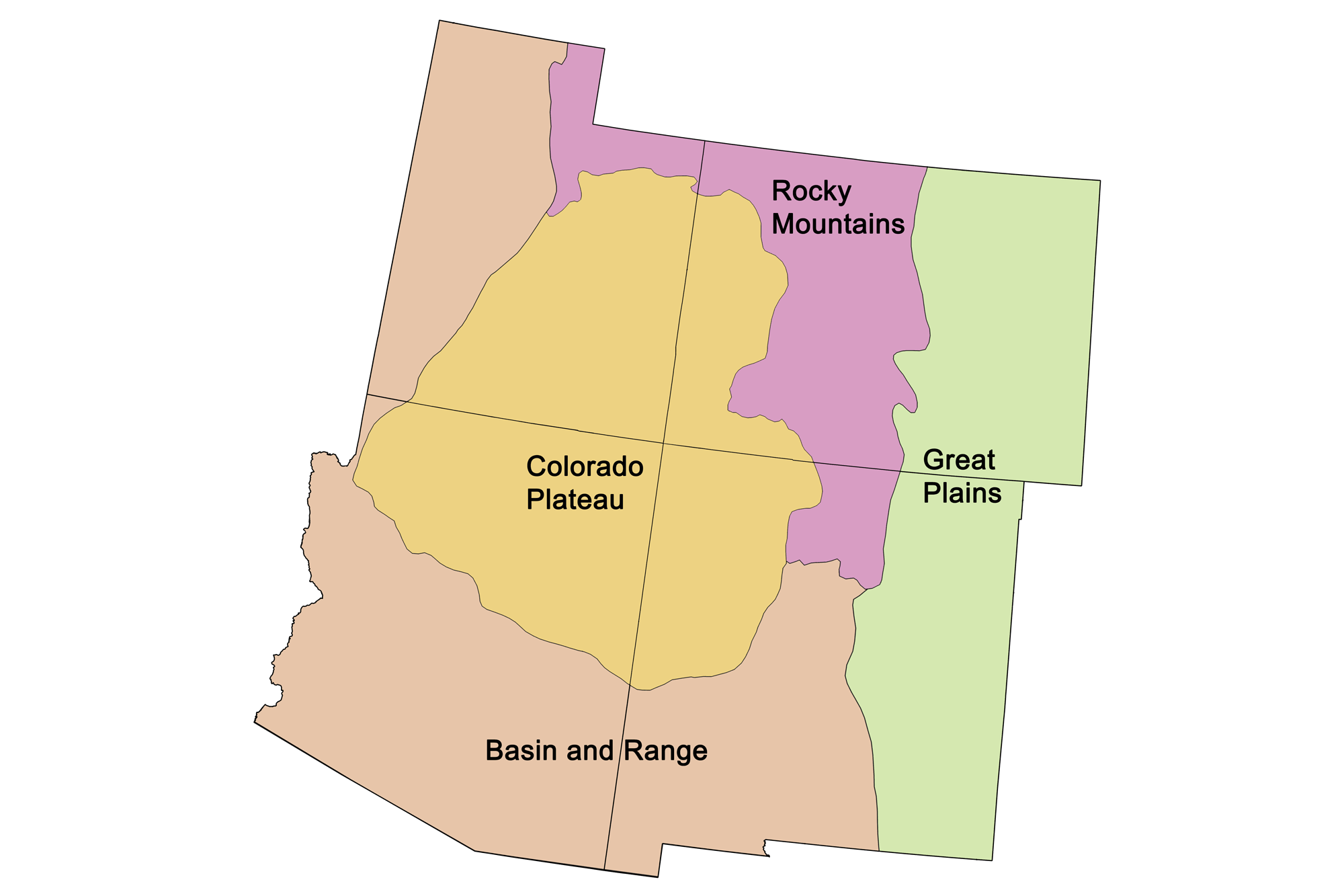
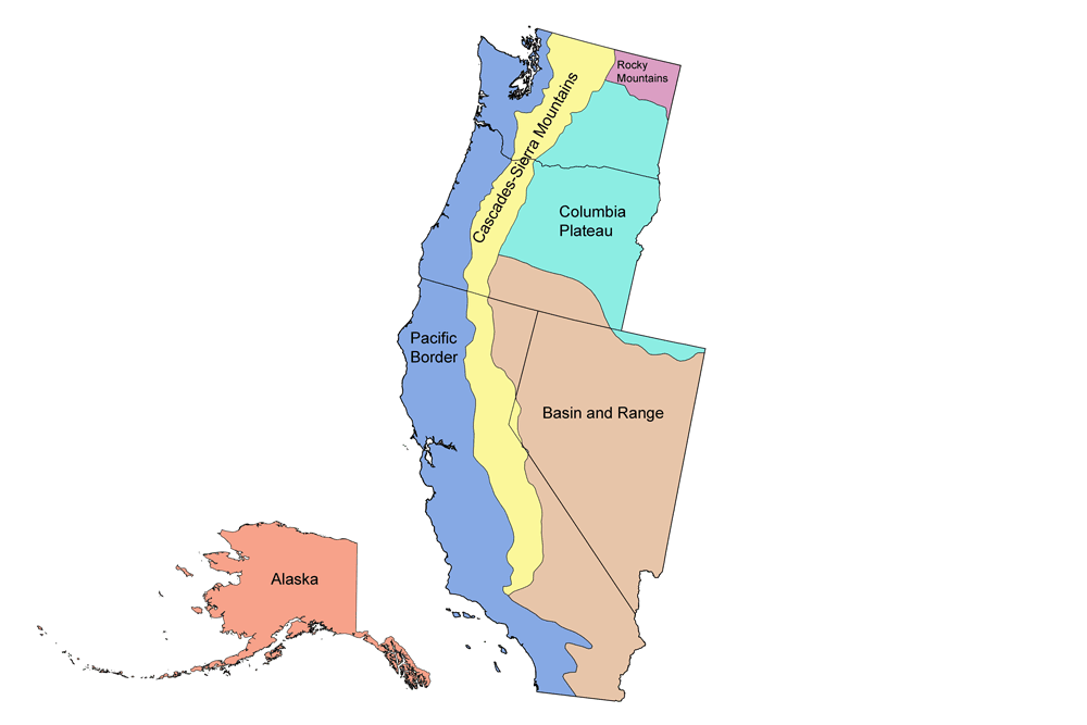
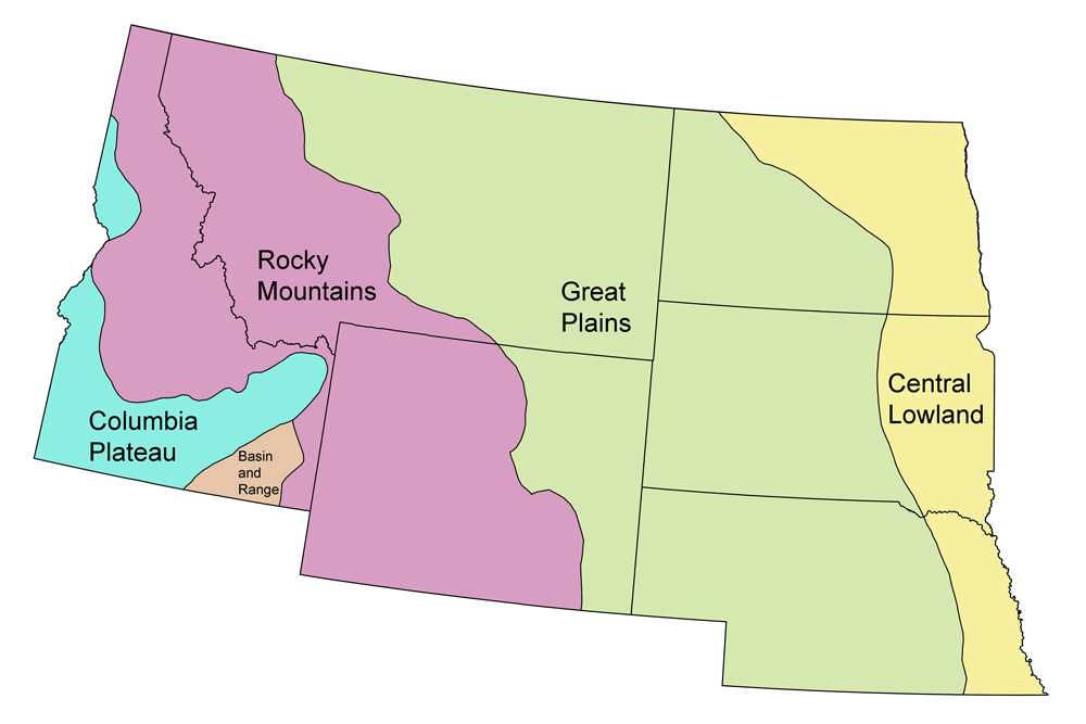
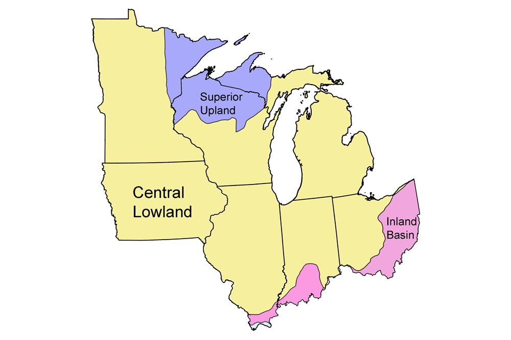
Geologic map of the United States.

Geologic Maps of the United States

Credits and permissions:

The maps on this page were created by Jonathan R. Hendricks for the Earth@Home project. Unless otherwise indicated, maps were created using QGIS and USGS data from Fenneman and Johnson (1946) and Horton et al. (2017) using the maximum age values for each mapped unit. All maps below have Creative Commons Attribution-NonCommercial-ShareAlike 4.0 International license. You are welcome to use them for any educational purpose.

This page was last updated on August 25, 2022.

Alabama


Alabama Earth Science Quick Facts
Earth Science of the Southeastern U.S.

Geologic map of Alabama.

Geologic map of Alabama with physiographic regions identified.

Alaska


Alaska Earth Science Quick Facts
Earth Science of the Western U.S.

Geologic map of Alaska.

Geologic map of Alaska. Image by Jonathan R. Hendricks for the Earth@Home project developed using QGIS and USGS data (public domain) from Wilson et al. (2015).

Arizona


Arizona Earth Science Quick Facts
Earth Science of the Southwestern U.S.

Geologic map of Arizona.

Geologic map of Arizona with physiographic regions identified.


Geologic and topographic map of Arizona.

Geologic and topographic map of Arizona. Geologic data from Horton et al. (2017) using the maximum age values for each mapped unit. Topographic data are derived from the Shuttle Radar Topography Mission (SRTM GL3) Global 90m (SRTM_GL3) (Farr, T. G., and M. Kobrick, 2000, Shuttle Radar Topography Mission produces a wealth of data. Eos Trans. AGU, 81:583-583).

Arkansas


Arkansas Earth Science Quick Facts
Earth Science of the South-Central U.S.
Geologic map of Arkansas with physiographic regions identified.

Geologic map of Arkansas with physiographic regions identified.

California


California Earth Science Quick Facts
Earth Science of the Western U.S.

Geologic map of California

Geologic map of California with physiographic regions identified.

Colorado


Colorado Earth Science Quick Facts
Earth Science of the Southwestern U.S.
Geologic map of Colorado.

Geologic map of Colorado with physiographic regions identified.

Geologic and topographic map of Colorado.

Geologic and topographic map of Colorado. Geologic data from Horton et al. (2017) using the maximum age values for each mapped unit. Topographic data are derived from the Shuttle Radar Topography Mission (SRTM GL3) Global 90m (SRTM_GL3) (Farr, T. G., and M. Kobrick, 2000, Shuttle Radar Topography Mission produces a wealth of data. Eos Trans. AGU, 81:583-583).

Florida


Florida Earth Science Quick Facts
Earth Science of the Southeastern U.S.

Geologic map of Florida.

Geologic map of Florida with physiographic regions identified.

Georgia


Georgia Earth Science Quick Facts
Earth Science of the Southeastern U.S.

Geologic map of Georgia with physiographic regions identified.

Geologic map of Georgia with physiographic regions identified.

Hawaii


Hawaii Earth Science Quick Facts
Earth Science of Hawaii
Geologic map of Hawaii.

Geologic map of Hawaii. Image by Jonathan R. Hendricks.

Idaho


Idaho Earth Science Quick Facts
Earth Science of the Northwest Central U.S.

Geologic map of Idaho.

Geologic map of Idaho with physiographic regions identified.


Combined geologic and topographic map of Idaho.

Geologic and topographic map of Idaho. Geologic data from Horton et al. (2017) using the maximum age values for each mapped unit. Topographic data are derived from the Shuttle Radar Topography Mission (SRTM GL3) Global 90m (SRTM_GL3) (Farr, T. G., and M. Kobrick, 2000, Shuttle Radar Topography Mission produces a wealth of data. Eos Trans. AGU, 81:583-583).

Illinois

Geologic map of Illinois.

Geologic map of Illinois with physiographic regions identified.

Combined geologic and topographic map of Illinois.

Geologic and topographic map of Illinois. Geologic data from Horton et al. (2017) using the maximum age values for each mapped unit. Topographic data are derived from the Shuttle Radar Topography Mission (SRTM GL3) Global 90m (SRTM_GL3) (Farr, T. G., and M. Kobrick, 2000, Shuttle Radar Topography Mission produces a wealth of data. Eos Trans. AGU, 81:583-583).

Indiana

Geologic map of Indiana.

Geologic map of Indiana with physiographic regions identified.

Combined geologic and topographic map of Indiana.

Geologic and topographic map of Indiana. Geologic data from Horton et al. (2017) using the maximum age values for each mapped unit. Topographic data are derived from the Shuttle Radar Topography Mission (SRTM GL3) Global 90m (SRTM_GL3) (Farr, T. G., and M. Kobrick, 2000, Shuttle Radar Topography Mission produces a wealth of data. Eos Trans. AGU, 81:583-583).

Iowa

Geologic map of Iowa.

Geologic map of Iowa with physiographic regions identified.

Combined geologic and topographic map of Iowa.

Geologic and topographic map of Iowa. Geologic data from Horton et al. (2017) using the maximum age values for each mapped unit. Topographic data are derived from the Shuttle Radar Topography Mission (SRTM GL3) Global 90m (SRTM_GL3) (Farr, T. G., and M. Kobrick, 2000, Shuttle Radar Topography Mission produces a wealth of data. Eos Trans. AGU, 81:583-583).

Kansas


Kansas Earth Science Quick Facts
Earth Science of the South-Central U.S.
Geologic map of Kansas with physiographic regions identified.

Geologic map of Kansas with physiographic regions identified.

Kentucky


Kentucky Earth Science Quick Facts
Earth Science of the Southeastern U.S.

Geologic map of Kentucky with physiographic regions identified.

Geologic map of Kentucky with physiographic regions identified.

Louisiana


Louisiana Earth Science Quick Facts
Earth Science of the South-Central U.S.
Geologic map of Louisiana with physiographic regions identified.

Geologic map of Louisiana with physiographic regions identified.

Minnesota

Geologic map of Minnesota.

Geologic map of Minnesota with physiographic regions identified.

Combined geologic and topographic map of Minnesota.

Geologic and topographic map of Minnesota. Geologic data from Horton et al. (2017) using the maximum age values for each mapped unit. Topographic data are derived from the Shuttle Radar Topography Mission (SRTM GL3) Global 90m (SRTM_GL3) (Farr, T. G., and M. Kobrick, 2000, Shuttle Radar Topography Mission produces a wealth of data. Eos Trans. AGU, 81:583-583).

Mississippi


Mississippi Earth Science Quick Facts
Earth Science of the Southeastern U.S.

Geologic map of Mississippi with physiographic regions identified.

Geologic map of Mississippi with physiographic regions identified.

Missouri


Missouri Earth Science Quick Facts
Earth Science of the South-Central U.S.
Geologic map of Missouri with physiographic regions identified.

Geologic map of Missouri with physiographic regions identified.

Montana


Montana Earth Science Quick Facts
Earth Science of the Northwest Central U.S.

Geologic map of Montana.

Geologic map of Montana with physiographic regions identified.

Nebraska


Nebraska Earth Science Quick Facts
Earth Science of the Northwest Central U.S.
Geologic map of Nebraska.

Geologic map of Nebraska with physiographic regions identified.

Nevada


Nevada Earth Science Quick Facts
Earth Science of the Western U.S.

Geologic map of Nevada.

Geologic map of Nevada with physiographic regions identified.

New Mexico


New Mexico Earth Science Quick Facts
Earth Science of the Southwestern U.S.

Geologic map of New Mexico.

Geologic map of New Mexico with physiographic regions identified.


Geologic and topographic map of New Mexico.

Geologic and topographic map of New Mexico. Geologic data from Horton et al. (2017) using the maximum age values for each mapped unit. Topographic data are derived from the Shuttle Radar Topography Mission (SRTM GL3) Global 90m (SRTM_GL3) (Farr, T. G., and M. Kobrick, 2000, Shuttle Radar Topography Mission produces a wealth of data. Eos Trans. AGU, 81:583-583).

North Carolina


North Carolina Earth Science Quick Facts
Earth Science of the Southeastern U.S.
Geologic map of North Carolina with physiographic regions identified.

Geologic map of North Carolina with physiographic regions identified.

North Dakota


North Dakota Earth Science Quick Facts
Earth Science of the Northwest Central U.S.
Geologic map of North Dakota.

Geologic map of North Dakota with physiographic regions identified.

Ohio

Geologic map of Ohio.

Geologic map of Ohio with physiographic regions identified.

Combined geologic and topographic map of Ohio.

Geologic and topographic map of Ohio. Geologic data from Horton et al. (2017) using the maximum age values for each mapped unit. Topographic data are derived from the Shuttle Radar Topography Mission (SRTM GL3) Global 90m (SRTM_GL3) (Farr, T. G., and M. Kobrick, 2000, Shuttle Radar Topography Mission produces a wealth of data. Eos Trans. AGU, 81:583-583).

Oklahoma


Oklahoma Earth Science Quick Facts
Earth Science of the South-Central U.S.
Geologic map of Oklahoma with physiographic regions identified.

Geologic map of Oklahoma with physiographic regions identified.

Oregon


Oregon Earth Science Quick Facts
Earth Science of the Western U.S.

Geologic map of Oregon.

Geologic map of Oregon with physiographic regions identified.

South Carolina


South Carolina Earth Science Quick Facts
Earth Science of the Southeastern U.S.

Geologic map of South Carolina, with physiographic regions identified.

Geologic map of South Carolina with physiographic regions identified.

South Dakota


South Dakota Earth Science Quick Facts
Earth Science of the Northwest Central U.S.
Geologic map of South Dakota.

Geologic map of South Dakota with physiographic regions identified.

Tennessee


Tennessee Earth Science Quick Facts
Earth Science of the Southeastern U.S.
Geologic map of Tennessee, with physiographic regions identified.

Geologic map of Tennessee with physiographic regions identified.

Texas


Texas Earth Science Quick Facts
Earth Science of the South-Central U.S.

Geologic map of Texas with physiographic regions identified.

Geologic map of Texas with physiographic regions identified.

Utah


Utah Earth Science Quick Facts
Earth Science of the Southwestern U.S.

Geologic map of Utah.

Geologic map of Utah with physiographic regions identified.


Geologic and topographic map of Utah.

Geologic and topographic map of Utah. Geologic data from Horton et al. (2017) using the maximum age values for each mapped unit. Topographic data are derived from the Shuttle Radar Topography Mission (SRTM GL3) Global 90m (SRTM_GL3) (Farr, T. G., and M. Kobrick, 2000, Shuttle Radar Topography Mission produces a wealth of data. Eos Trans. AGU, 81:583-583).

Virginia


Virginia Earth Science Quick Facts
Earth Science of the Southeastern U.S.

Geologic map of Virginia with physiographic regions identified.

Geologic map of Virginia with physiographic regions identified.

Washington


Washington Earth Science Quick Facts
Earth Science of the Western U.S.

Geologic map of Washington.

Geologic map of Washington with physiographic regions identified.

West Virginia


West Virginia Earth Science Quick Facts
Earth Science of the Southeastern U.S.

Geologic map of West Virginia, with physiographic regions identified.

Geologic map of West Virginia with physiographic regions identified.

Wisconsin

Geologic map of Wisconsin.

Geologic map of Wisconsin with physiographic regions identified.


Combined geologic and topographic map of Wisconsin.

Geologic and topographic map of Wisconsin. Geologic data from Horton et al. (2017) using the maximum age values for each mapped unit. Topographic data are derived from the Shuttle Radar Topography Mission (SRTM GL3) Global 90m (SRTM_GL3) (Farr, T. G., and M. Kobrick, 2000, Shuttle Radar Topography Mission produces a wealth of data. Eos Trans. AGU, 81:583-583).

Wyoming


Wyoming Earth Science Quick Facts
Earth Science of the Northwest Central U.S.
Geologic map of Wyoming.

Geologic map of Wyoming with physiographic regions identified.