

Page Snapshot: Introduction to major types of Earth hazards, including natural disasters like earthquakes, tornados, and floods.
Topics covered on this page: Earthquakes; Tsunamis; Volcanoes; Landslides; Sinkholes; Asbestos; Radon; Floods; Sea level rise, coastal erosion, and subsidence; Weather hazards; Resources.
Credits: Most of the text on this page comes from "Earth Hazards of the Southeastern US" by Warren D. Allmon, Andrielle N. Swaby, and Don W. Byerly, chapter 9 in The Teacher-Friendly Guide to the Geology of the Southeastern U.S., 2nd. ed., edited by Andrielle N. Swaby, Mark D. Lucas, and Robert M. Ross (published in 2016 by the Paleontological Research Institution; currently out of print). Some additional content comes from The Teacher-Friendly Guide to the Earth Science of the Western US, edited by Mark D. Lucas, Robert M. Ross, and Andrielle N. Swaby (PRI, 2014). These books were adapted for the web by Elizabeth J. Hermsen and Jonathan R. Hendricks in 2021–2022. Changes include formatting and revisions to the text and images. Credits for individual images are given in figure captions.
Updates: Page last updated April 13, 2022.
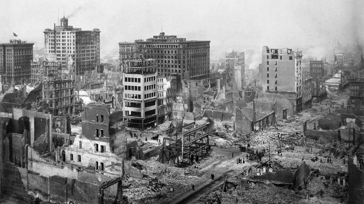
Image above: Damage resulting from the San Francisco Earthquake of 1906. Photograph by H. D. Chadwick (Wikimedia Commons; public domain).
Earthquakes
Earthquakes occur when a critical amount of stress is applied to the Earth's crust and the crust responds by moving. Most often, this stress is caused by the movements of tectonic plates as they crunch into or slide past each other. In other instances, earthquakes may occur near ancient fault zones. Because of this, some regions of the United States are much more prone to earthquakes than others.
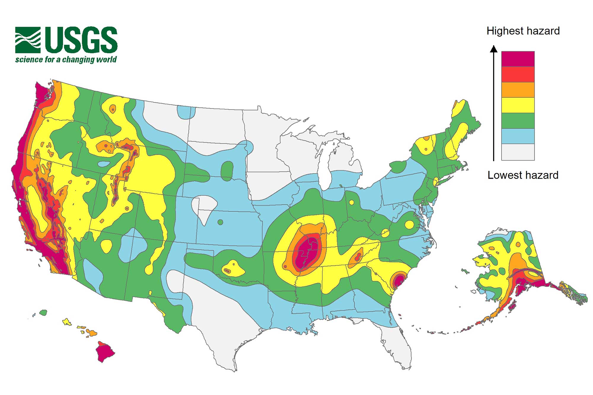
USGS 2018 long-term national seismic hazard map. Image by USGS (public domain).
Elastic rebound theory
According to the elastic rebound theory, rocks can bend elastically up to a point, until they finally break. The rocks then snap apart. This release of energy forms of seismic waves, causing an earthquake to happen.
"Elastic Rebound Theory" by Harmony Square (YouTube).
Faults
The plane defined by the rupture of an earthquake is known as a fault, and the surrounding rock layers become offset along it.
Interactive image of a fault in chalk; note the offset of the rock layers. Original caption: "Normal fault in the Fort Hays member of the Cretaceous Niobrara Formation, south of Stockton, Kansas. These chalk beds were originally deposited in the shallow Western Interior Seaway about 80 million years ago. The thick beds of the Fort Hays member are extensively bioturbated. Faulting is post-Cretaceous and pre-Quaternary." Image by Ron Schott (GIGAMacro; Creative Commons Attribution 4.0 International license).
Many earthquakes arise along pre-existing faults, for example the famous San Andreas Fault in California. In cases such as these, stress may accumulate from lateral compressive pressure, as the rocks are temporarily locked in position by friction and other constraints, until sufficient strain energy has built up to cause sudden slippage along the fault (i.e., an earthquake).
Measuring earthquakes
There are two common ways to measure the size of earthquakes: magnitude and intensity. Magnitude (M) is the measure of the energy released by the earthquake, whereas the intensity is what people actually experience. The first scale used to measure magnitude was the Richter scale (abbreviated ML), which measures the amplitude of a seismic wave at a defined distance from the source of the earthquake. The Richter scale was designed to classify earthquakes at a local scale, but it does not do a very good job of describing the energy released by very large earthquakes. Geologists therefore developed another measurement, the Moment Magnitude scale (abbreviated Mw), which was introduced in 1979. The Moment Magnitude estimates the total energy released by an earthquake along an entire fault surface.
Both the Richter and Moment Magnitude scales are logarithmic, meaning that an M9.0 earthquake has 10 times the amplitude, and releases 32 times the energy, of an M8.0 earthquake. Accordingly, an M9.0 earthquake would have 100 times the amplitude and 1024 times the energy of an M7.0 earthquake. Both scales may appear to reach maximum values of 10 (since the largest recorded earthquakes are slightly greater than 9), but technically there is no upper limit. The United States Geological Survey (USGS) describes earthquakes as minor (M3.0–3.9), light (M4.0–4.9), moderate (M5.0–5.9), strong (M6.0–6.9), major (M7.0–7.9), and great (M8.0 and higher). The largest recorded earthquake in US history was the 1964 Alaskan earthquake, which had an Mw of 9.2. By comparison, the largest recorded earthquake in the Southeast occurred in 1886 in Charleston, South Carolina (M7.3) (see more below).
"Earthquake Magnitude Power Comparison" by Reigarw Comparisons (YouTube).
The 1964 Alaskan earthquake and the 1906 San Francisco earthquake had roughly the same Richter magnitudes, but based on the size of the affected areas and geological movement, the Alaskan earthquake clearly released more energy than the San Francisco earthquake did. Geologists recalculated the magnitudes of these major quakes using the Moment Magnitude scale: the 1964 Alaskan earthquake, which originally had an ML of 8.3, was found to have had an MW of 9.2, whereas the 1906 San Francisco earthquake had an ML of 8.3 and an MW of 7.9.
The magnitude of an earthquake does not tell us how much damage it causes. The amount of shaking and damage is known as the earthquake's intensity, and it can be measured by the Modified Mercalli Intensity (MMI) scale. This scale uses the Roman numerals I–XII to describe the effects of the earthquake in a particular location. For example, near the epicenter of a small earthquake, or at a location far from a large earthquake, the intensity may be described with an MMI of II: "Felt only by a few persons at rest, especially on the upper floors of buildings. Delicately suspended objects may swing." Unlike the Moment Magnitude scale, the MMI scale is a subjective gauge, and the USGS has attempted to improve the accuracy of MMI shake maps by soliciting data from the public.
"Modified Mercalli Intensity Scale Explained" (YouTube).
Detection and vulnerabilities
Networks of seismograph stations have improved geologists' ability to detect and accurately locate earthquake hazards. Information about earthquake risk can lead to better designs for high-risk infrastructure like dams, high-rise buildings, and power plants—and it can also be used to inform the public of potential hazards to lives and property. The hazards associated with earthquakes are mainly related to collapsing buildings and other structures, fire related to broken gas lines and other utilities (and broken water lines preventing firefighting), and in some instances—especially along coastal regions located adjacent to active tectonic zones—tsunamis, seismic sea waves produced by earthquakes.
Earthquake hazards in the United States
Use the links below to explore earthquake-associated risks in different regions of the United States (more regions will be added soon):
Tsunamis
A tsunami is a series of ocean waves that are generated by the sudden displacement of water. Although earthquakes are the most common cause, tsunamis may also be generated by landslides, volcanic explosions, meteor impacts, nuclear explosions, and glacier calving.
Unlike a wind-generated sea wave, a tsunami wave has an extremely long wavelength. A very large wind-generated wave might have a wavelength of 200 meters (650 feet), but a typical tsunami has a wavelength of 200 kilometers (120 miles). Incredibly, tsunamis can travel at 800 kilometers per hour or kph (500 miles per hour or mph) in the open ocean.
Although tsunamis have extremely long wavelengths, while at sea they have only minimal height. In fact, ships in the open ocean may never notice the passing of a tsunami wave. As the wave approaches shore, however, the wavelength decreases and the wave height (amplitude) increases as the water “piles up” upon reaching shallower depths. Even a tsunami with a moderate wave height can do great damage, however, because the great wavelength means it may take a single wave 20 to 30 minutes to sweep up the shore. Such waves resemble a wall of water more than a simple breaking wave.
"How tsunamis work" by Alex Gendler / TED-Ed (YouTube).
The tallest wave ever recorded occurred in Lituya Bay, located along the Alaskan Panhandle. On the night of July 9, 1958, a M8.5 earthquake initiated a landslide. Thirty million cubic meters (forty million cubic yards) of rock plunged into the bay, creating a local tsunami that destroyed all trees and vegetation up to a height of 524 meters (1720 feet) above the bay. Unusually high tsunamis are referred to as megatsunamis. This category includes landslide-generated tsunamis as well as tsunamis generated by a meteor impact, such as the meteor that struck 66 million years ago, causing the extinction of the dinosaurs. The height of the wave caused by that impact is estimated to have been as much as 5 kilometers (3 miles) high!
Often the trough of a wave will arrive before the crest, making it appear as if the sea is retreating. This strange sight might give residents time to escape before the crest arrives, if they recognize that the drawdown is a warning sign and not just the tide going out very quickly.
Volcanoes
Volcanoes typically occur above tectonically active areas of the Earth. They are commonly associated with subduction zones (where one plate is pushed beneath another plate) or tectonic hot spots associated with upwelling in the mantle. Volcanic hazards include lava and ash eruptions, and the emission of corrosive volcanic gasses.
Stratovolcanoes
A stratovolcano is a conical volcano made up of many lava flows as well as layers of ash and breccia from explosive eruptions. In fact, stratovolcanoes are often characterized by their periodic violent eruptions, which occur due to their presence at subduction zones. While young stratovolcanoes tend to have steep cone shapes, the symmetrical conical shape is readily disfigured by massive eruptions. Older stratovolcanoes further lose their symmetry due to erosion, especially because volcanoes are inherently unstable mountains. Many older stratovolcanoes contain collapsed craters called calderas.
Mt. Saint Helens, which is part of the Cascade Range in Washington, is an example of a stratovolcano. Its most spectacular eruption occurred on May 18, 1980, when an earthquake shook the side of the mountain, triggering the largest landslide ever recorded. An explosive blast issued from the side of the mountain, reaching speeds up to 480 kph (300 mph) as it flattened forests in its path. Avalanches of hot ash and pumice called pyroclastic flows sped quickly down the side of the volcano and spread for miles. The volcano’s rapidly melted glaciers created lahars that took out 27 bridges and 200 homes. Despite evacuations in the weeks leading up to the eruption, 57 people died during the explosion. It was the deadliest and most costly volcanic event in U.S. history. Mt. Saint Helens continues to be active, and it has built a lava dome inside its crater.
"Footage of the 1980 Mount St. Helens Eruption" by Smithsonian Channel (YouTube).
Shield volcanoes
Shield volcanoes have a low profile and gradual slope, so named for their likeness to the profile of an ancient warrior’s shield. Shield volcanoes erupt low-viscosity magma that is more fluid than the “sticky” silica-rich lavas that build up stratovolcanoes. Repeated eruptions of fluid lava build large, gently sloping mountains with an expansive size.
The Hawaiian islands are examples of shield volcanoes formed over a tectonic hot spot.
"Kilauea Volcano Eruption | A Perfect Planet" by BBC Earth (YouTube).
Landslides
The term "landslide" refers to a wide range of mass wasting events that result in rock, soil, or fill moving downhill under the influence of gravity. For example, a major landslide occurred across a section of California's famous Highway 1 south of Big Sur in 2017, resulting in a section of the highway being completely buried.
"Landslide Reshapes Big Sur Coastline" by KPIX CBS SF Bay Area (YouTube).
These events occur when friction between the earth material (i.e., rock and soil) and the slope is overcome, allowing the earth material to fail and move downslope. Mass wasting events can also dam streams and rivers, creating lakes.
Landslides may be triggered by high rainfall, earthquakes, erosion, deforestation, groundwater pumping, or volcanic eruptions. They range in size from the simple raveling of a stream embankment to the collapse of an entire mountainside that involves tens of thousands of cubic meters (yards) of material.
Mud and debris flows are very fast landslides likely to kill anyone unfortunate enough to be caught in their path, as they can reach speeds exceeding 32 kilometers per hour (20 miles per hour). Debris flows are a dangerous mixture of water, mud, rocks, trees, and other debris that moves quickly down valleys. Rapid slides and flow movement happens without warning, triggered by heavy rainfall, snowmelt, or high levels of ground water flowing through cracked bedrock.
Slumping occurs when expansive minerals like clays—which can absorb water and swell up to twice their original volume—are present on steeper slopes, and involves the downward movement of a larger block of material along a surface that fails when the weight of the saturated soils can no longer be supported. Slumping is common near roads and highways, thanks to the presence of steeper hills, roadcuts, and construction. On steep, high slopes, slumping often precedes earthflows and mudflows that develop farther downslope as water is added to the slump while it mixes the moving material.
Damage to life and property from mass wasting events can be reduced by avoiding landslide hazard areas or by restricting access to known landslide zones. Hazard reduction is possible by avoiding construction on steep slopes or by stabilizing the slopes. There are two main ways to accomplish stabilization: (1) preventing water from entering the landslide zone through runoff, flooding, or irrigation; and (2) stabilizing the slope by placing natural or manmade materials at the toe (bottom) of the landslide zone or by removing mass from the top of the slope.
Not all mass wasting events are rapid—slow land movement, known as soil creep, is generally not hazardous, but can impact structures over a long period of time.
Karst and sinkholes
Karst topography forms in areas where the underlying bedrock is composed of material that can be slowly dissolved by water. Examples of this type of sedimentary rock include carbonate rocks such as limestone, halite, gypsum, dolomite, and anhydrite. Carbonate rocks may develop karst and other dissolution features due to the effects of circulating groundwater that has been made slightly acidic through the presence of dissolved carbon dioxide (which creates carbonic acid that reacts with the rock, dissolving it).
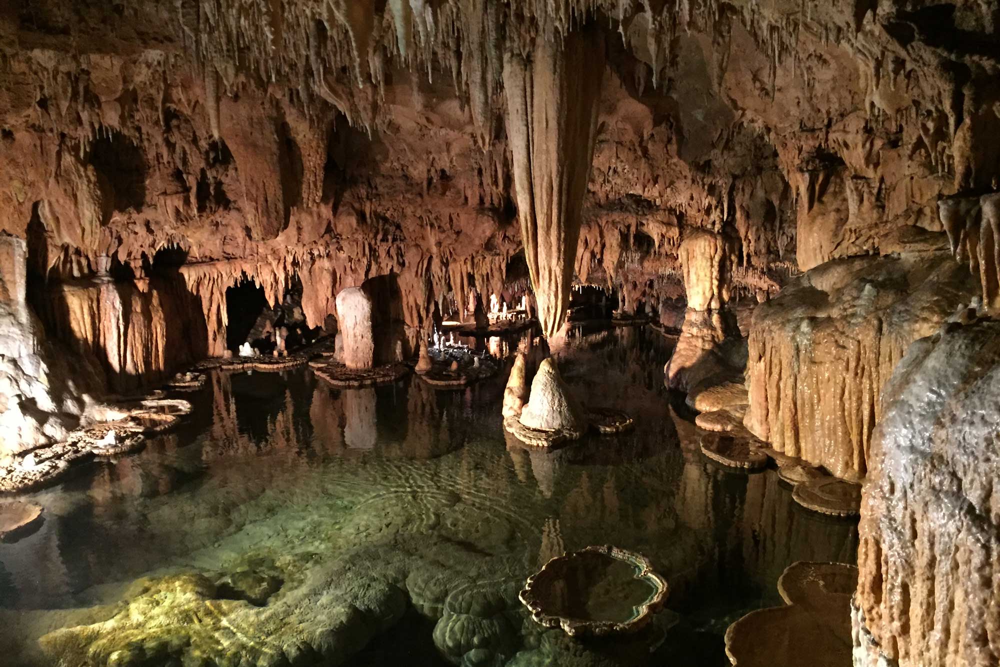
A cavern inside of Onondaga Cave State Park, Missouri. Photograph by Jonathan R. Hendricks.
"Travel inside a sinkhole" by CNN (YouTube).
Sinkholes are funnel-shaped depressions in the land surface formed by the dissolution of near-surface rocks or by the collapse of underground channels and caverns. Sinkholes can form by several different mechanisms, but all require dissolution of rock beneath the surface.
Sinkholes and caverns can form in karst topography, creating potential hazards (i.e., the land surface could subside or collapse into the underground openings). This may principally occur in areas where cavities filled with water are emptied through groundwater withdrawal or other natural processes, resulting in the cavities being filled with air and reducing support for the overlying rock.
"How Do Sinkholes Form?" by Practical Engineering (YouTube).
Sinkholes may be very small or large enough to swallow even hectares (acres) of land, along with any structures that had been built upon the surface. The early stages of sinkhole development may be indicated by signs of mass wasting such as "pistol-grip"-shaped trees, cracked building foundations, and leaning fence posts. Structural damage from sinkholes can be mitigated, but usually only at significant cost. It is therefore often far more prudent to avoid building in such locations altogether.
"Sinkhole Rapidly Grows, Swallows Central Florida Homes" by NBC News (YouTube).
Evaluating sinkhole risk commonly involves foundation testing by drilling or remote sensing (for example, measuring electrical resistivity) prior to construction. Unfortunately, many structures have been built without such testing, resulting in frequent catastrophic damage. Many state agencies provide sinkhole risk maps, which provide generalized risk assessment based on local geology
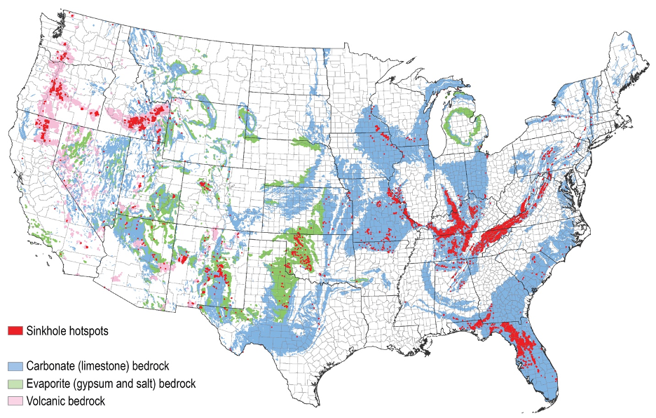
Regions of the United States where sinkholes are common. Image by USGS (public domain).
Asbestos
The name asbestos is used to describe a variety of fibrous minerals, including chrysotile and crocidolite, which occur naturally as bundles of fibers that can be separated into durable filaments.
Interactive 3D model. Original caption: "This sample of chrysotile comes from Waldheim, Germany. It is 7 cm wide. Chrysotile is the most common of the asbestos minerals." Model by "rocksandminerals" (Sketchfab; Creative Commons Attribution 4.0 International license).
The fibers are non-conductive and naturally resistant to chemicals and heat. During the early twentieth century, asbestos was commonly mined for its numerous industrial applications such as weather insulation and fireproofing for buildings. However, when asbestos-laden dust is inhaled, the microscopic mineral fibers are capable of piercing and damaging the cells in which they come into contact. This can cause lung irritation and lead to serious health problems, including cancer.
While many people worry about the asbestos insulation hazards found in older buildings, few consider the hazards associated with the minerals’ natural occurrence. Natural asbestos sources can be found throughout the Southwest, and it has been mined in both Utah and Arizona, though these mines are no longer in operation thanks to recent limitations placed on the minerals’ use. Remediation attempts on abandoned mines include blocking off access to contaminated areas and burying contaminated soil that has been found near surface water sources.
Natural events such as landslides can release previously trapped asbestos minerals, which can then be transported across great distances by the wind or even carried by surface water running over an asbestos site. Asbestos crystals can then make their way into streams and lakes, spreading contamination over large areas. People within the vicinity of exposed sources are at risk from windblown particles and mud particles collected on their shoes, clothing, and vehicles. The particles can then be carried into homes.
Radon
Radon is a naturally occurring radioactive, colorless, odorless gas. It is the leading cause of lung cancer in American non-smokers, and the second leading cause of lung cancer overall. It can collect in homes, buildings, and even in the water supply. Radon gas is formed naturally when uranium-238 undergoes radioactive decay, producing energy and several radioactive products such as radon-222 and thorium-232. (The thorium later decays to emit energy and radon-220.)
Radon is more commonly found where uranium is relatively abundant in bedrock at the surface, often in granite, shale, and limestone. The EPA produced a map of the US showing geographic variation in radon concentrations, divided into three levels of risk: high, medium, and low.
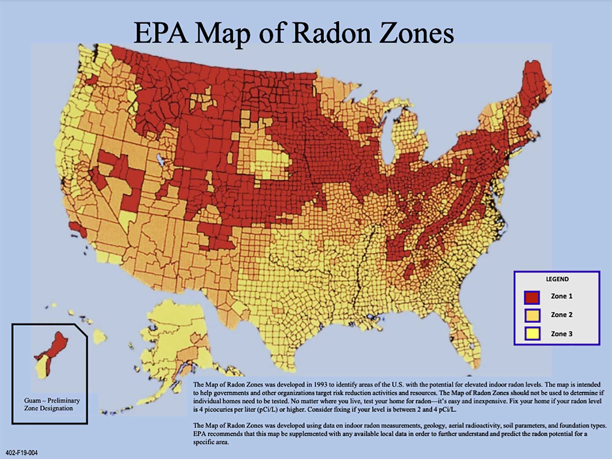
Map of radon zones in the United States (counties in red have the highest levels of radon). Image by the EPA (public domain).
Although radon is more or less universally present, high levels of radon are associated with areas containing uranium-rich bedrock. Most rocks have a small amount of uranium, but certain rocks tend to have higher concentrations of the radioactive element, such as light-colored volcanic rocks, granites, dark shales, sedimentary rocks with phosphates, and metamorphic rocks.
Radon is chemically inert, meaning that it does not react or combine with elements in the ground, and it can move up through rocks and soil into the atmosphere. It is dangerous primarily when it accumulates indoors, creating a health hazard similar to that of secondhand smoke. Radon gas finds its way through cracks in basement foundations, sump pump wells, dirt floor crawlspaces, and basement floor drains. It can also be found in well and municipal water. Since radon is more easily released from warm water than from cold water, one of the greatest forms of exposure likely occurs while showering in water with high radon levels.
Radon cannot be detected by sight or smell, so there is no way that the body can sense its presence. Fortunately, with proper monitoring and mitigation (reduction) techniques, radon gas can be easily reduced to low levels. One technique that is often used in homes involves sealing cracks in the basement floor, covering drains, and installing ventilation systems. A well-ventilated space will prevent the radon from accumulating and will reduce the risk of exposure. Most states have licensed radon mitigation specialists who are trained in the proper testing and mitigation of radon levels in buildings. The EPA has also published a homebuyer's guide designed to help citizens make informed decisions about radon gas. For radon in water, filtration systems can be installed to mitigate exposure in the home.
Floods
Floods are controlled by the rate of precipitation, run-off, stream flow, and shape of the land surface. They may occur as water overflows the banks of a standing water body (such as a lake) or flowing water (such as a stream), or when rainwater accumulates in an area that normally has neither standing nor flowing water. Areas near rivers, tributaries, creeks, and streams are likely to experience flooding during periods of heavy rainfall. Low-lying coastal areas can experience flooding associated with major storms, which can combine high rainfall with surging waves.
"New York City subwaysshut down due to Ida's flash flooding" by ABC News (Sept. 2, 2021) (YouTube).
Flooding can occur at any time of the year and is caused when more water enters a stream/river channel than the channel can contain. This situation can develop when water is unable to soak into the ground and instead runs off into a river channel. Runoff can occur if the ground is already saturated (full of water) or if the ground is too dry, hard, or frozen.
The slope of a river (i.e., the topography of the land) can also contribute to flooding. If rivers have a steep slope, water can quickly move through the channel and continue downstream. If rivers have a shallow slope, water moves slowly through the river channel and remains in the area instead of moving downstream.
Flash floods
Large floods typically result from unusually rapid regional melting of snow in the spring or from major weather systems such as hurricanes that bring heavy rainfall over a large region. Flash floods—rapid flooding of low-lying areas—are often associated with heavy rain, which can quickly waterlog soil and lead to mudslides on steep terrain, resulting in damage to roads and property.
In areas of lower elevation, flash floods can be produced when slow-moving or multiple thunderstorms occur over the same area. When storms move more quickly through an area, flash flooding is less likely. Although flash floods may be of only a short duration, they can cause major damage—flash floods have been known to wash coffins out of graveyards, destroy structures, and demolish manmade dams.
Floodplains
Floodplains are areas adjacent to rivers and streams that occasionally flood but are normally dry, sometimes for many years. When storms produce more runoff than a stream can carry in its channel, waters rise and inundate adjacent lowlands, leaving behind layers of settled sediment. Significant damage and sometimes loss of human life can occur when buildings and other human infrastructure are built on floodplains, under the assumption that future floods may never occur or will only occur in the distant future. Floods can occur at any time, but major floods are more frequent in spring and fall after periods of heavy or sustained rains when stream levels rise rapidly.
Flooding frequency and planning
While floods are always considered a hazard to life and property, they present a compound threat when they trigger mudslides or contribute to the conditions that cause expansive soils and karst topography. While there is no way to completely avoid the destructive impacts of flooding, good community planning and informed decision-making can greatly reduce the safety concerns and economic impacts of these events.
Flood control is part of the mission statements of many government agencies, including the National Resource Conservation Service (NRCS), US Corps of Engineers (USCE), and US Geological Survey (USGS). These agencies and others maintain gauges from which flow data are gathered. Using historical records and flow data collected over a long period of time, hydrogeologists can apply statistics to calculate the frequency and recurrence intervals of flows of different magnitude. These data have been used by the USGS to produce special topographic maps showing flood-prone areas. The Federal Emergency Management Agency (FEMA) provides guidelines for communities that are planning mitigation strategies designed to minimize the impacts of natural hazards such as flooding. The First Street Foundation (a private organization) has also created a website called Flood Factor that you can use to evaluate flooding risks at your home address.
Sea level rise, coastal erosion, and subsidence
Sea level rise and storm surges
Sea level changes affect the balance between erosion and deposition along the coast. About 20,000 years ago during the ice age, the waterfront along the coast of the present United States extended about 320 kilometers (200 miles) farther into the Atlantic Ocean. As the continental glaciers melted, water drained back into the oceans, causing sea level to continually rise over the past 2000 years.
The continual rise in sea level alone poses hazards, but it also increases the effects of storm surge on coastal communities. Although various estimates have been made for the rate of sea level rise, the general consensus is that it is within the range of 1 to 3 millimeters (0.04 to 0.12 inches) per year, but these values may actually be increasing. While coastal hazards related to sea level fluctuations are important when considering the long term, it is short-term events such as storm surges that pose major threats to property and life.
"Experience Storm Surge Like You Never Have Before" by The Weather Channel (YouTube).
The sudden rise in sea level generated by a storm surge and high winds causes water to flow over low-elevation coastlines and spill into low coastal river valleys. Hurricanes are by far the most common cause for surges; however, severe storms not reaching hurricane magnitude can still create hazardous surges. Most lives lost in a storm surge are a result of drowning or the collapse of structures. The property damage from a single event can range into billions of dollars.
Coastal erosion
Devices such as constructed islands, walls, breakwaters, groins, and piers that are exposed to waves and wave-generated currents are capable of being eroded and destroyed if not constructed upon sound foundations. Erosion also takes a critical toll on wildlife habitat, especially turtles and birds that use sandy shores and dunes for nesting.
Subsidence
Subsidence is the local sinking of land, involving little or no horizontal motion. It is induced through either the natural or anthropogenic removal of underlying support. Compaction of sediment, extraction of water and minerals from the soil, and collapse along fault lines are combining to increase the rate of subsidence.
Weather hazards
Weather relates to short-term atmospheric conditions such as temperature, wind speed, and humidity.
Rainstorms
Rainstorms occur where colder air from higher latitudes abruptly meets warmer air. At the boundary between warmer and cooler air, buoyant warm air rises and then cools because air pressure decreases with increasing height in the atmosphere. As the air cools, it becomes saturated with water vapor. Next, condensation occurs and clouds begin to form. Because liquid water droplets in the clouds must be very small to remain suspended in the air, a significant amount of condensation causes small water droplets to come together, eventually becoming too large to remain suspended. Sufficient moisture and energy can lead to dramatic rainstorms. Warm air has a lower pressure relative to cold air and the movement of air from areas of high pressure to areas of low pressure generates wind. The significant difference in air pressure associated with cold air and warm air boundaries therefore also generates strong winds (in addition to rainstorms).
"What Causes a Thunderstorm?" by NOAA SciJinks (YouTube).
Derechos
While severe thunderstorms are common in many parts of the United States, two less common storm hazards have the potential to cause serious property damage and endanger lives: derechos and tornados. Both of these storm events are associated with wind shear, which occurs when the wind's speed or direction changes with increasing height in the atmosphere. Wind shear can happen when a cold front moves rapidly into an area with very warm air. There, the condensing water droplets mix with the cooler, drier air in the upper atmosphere to cause a downdraft. When these downdrafts are very powerful, they can cause a derecho, or a set of powerful straight-line winds that exceed 94 kilometers per hour (58 miles per hour) and can often approach 160 kilometers per hour (100 miles per hour). These powerful windstorms can travel over 400 kilometers (250 miles) and cause substantial wind damage, knocking down trees and causing widespread power outages. The lightning associated with these intense storms can cause both forest fires and house fires.
"Cedar Rapids, Iowa - Derecho Caught on Camera" (August 10, 2020) by Iowa Storm Chasing Network (YouTube).
Tornadoes
The differences between tornadoes and derechos are indicated in their names: derecho is the Spanish word for straight ahead, while the word tornado has its roots in the Spanish word tonar, which means to turn. Both types of storm events can be associated with the same major cold front boundary because they require similar conditions to get started. However, tornado formation is more complicated. At the frontal boundary, warm, moist air rapidly rises as cooler, dry air descends; in the meantime, the pressure differences between the warm and cold air masses cause strong winds. Clouds with a visible horizontal rotation can appear, appearing to roll like waves crashing on the shore of a beach. This horizontal motion can tilt, lifting the rotating cloud vertically, and the rolling cloud will form a tornado.
"Tornadoes 101" by National Geographic (YouTube).
Most tornados will last a few seconds to several minutes. During that time, many tornado-prone areas will use tornado sirens to alert residents of the danger. A smaller tornado might generate flying debris that can cause injury or damage to buildings, while larger tornados can cause buildings and houses to be completely broken apart. Tornados are classified by their ranking on the Enhanced Fujita scale, or EF scale. These classifications are estimates of wind speeds based on the type of damage that is observed following the storm.
Measuring tornado intensity
| EF Scale | Estimated Wind Speed (kph) | Estimated Wind Speed (mph) |
|---|---|---|
| EF0 | 104–137 | 65–85 |
| EF1 | 138–177 | 86–110 |
| EF2 | 178–217 | 111–135 |
| EF3 | 218–266 | 136–165 |
| EF4 | 267–322 | 166–200 |
| EF5 | >322 | >200 |
Although specific tornado paths are not predictable, the conditions that produce them are used to alert people so that they can seek shelter. The National Weather Service issues a watch, if the conditions are right for a type of storm event, or a warning, if the conditions are occurring or imminent for the storm event. The National Weather Service is part of NOAA, which maintains a U.S. map of all current watches and warnings.
Because atmospheric conditions can change very quickly, an important factor in preventing loss of human life is getting the public to act upon the severe weather alerts. One recent attempt to improve public response to warnings is through a tornado alert index that helps people evaluate the risk of a local tornado. The Tor:Con index used by the Weather Channel provides a number from 1 to 10 that represents the probability of a tornado occurring. Meteorologists evaluate the atmospheric conditions associated with a storm and assign a score. For example, a 4 on the Tor:Con index would indicate a 40%, or moderate, chance of a tornado forming in a particular area.
Hurricanes
Hurricanes occur when a warm, moist, low-pressure air mass forms over the Atlantic Ocean south and east of Florida. These storms gather strength as warm surface ocean water evaporates in the summer, yielding humid, low pressure air that rises; the moisture condenses into water droplets that form clouds, releasing latent heat, and thereby providing energy for even greater evaporation of warm ocean water. This positive feedback cycle continues until the low-pressure center moves over land.
"Hurricanes 101" by National Geographic (YouTube).
These storms are considered tropical depressions when wind speeds are below 63 kilometers per hour (39 miles per hour). As the storm grows, it develops a more organized structure, with warm air rising in the center and somewhat discrete bands of rain being formed. It becomes known as a tropical storm when its wind speeds reach the 63–117 kilometers per hour (39–73 miles per hour) range, and it is called a hurricane once winds have reached 119 kilometers per hour (74 miles per hour). Hurricane intensity is measured using the Saffur-Simpson scale, which categorizes hurricanes from 1 to 5 based on their windspeed.
Measuring hurricane intensity
| Saffur-Simpson hurricane scale | Wind speed (kph) | Wind speed (mph) |
|---|---|---|
| Category 1 | 119–153 | 74–95 |
| Category 2 | 154–177 | 96–110 |
| Category 3 | 178–208 | 111–129 |
| Category 4 | 209–251 | 130–156 |
| Category 5 | ≥252 | ≥157 |
Hurricanes are ranked in the Saffir-Simpson scale from category 1 to 5, with 5 being the highest, based on wind speed. Category 5 hurricanes occur on average only about once every three years in the Atlantic and Gulf of Mexico.
The western Atlantic, Caribbean, and Gulf of Mexico area is one of the world's most active for hurricanes, though they also occur in areas of the western Pacific, where they are known as typhoons, and in the South Pacific to Indian Ocean, where they are called cyclones.
Extreme temperature and draught
Extreme temperatures can create dangerous conditions for people and may lead to property damage. Heat waves are periods of excessively hot weather that may also accompany high humidity. Temperatures of just 3°C (6°F) to 6°C (11°F) above normal are enough to reclassify a warm period as a heat wave. Under these conditions, the mechanism of sweating does little to cool people down because the humidity prevents sweat from evaporating and cooling off the skin. Heat waves have different impacts on rural and urban settings. In rural settings, agriculture and livestock can be greatly affected. Heat stress recommendations are issued to help farmers protect their animals, particularly pigs and poultry, which, unlike cattle, do not have sweat glands.
The impacts of heat waves on urban settings include a combination of the natural conditions of excessive heat and the social conditions of living in a densely populated space. Cities contain a considerable amount of pavement, which absorbs and gives off more heat than vegetation-covered land does. Air conditioning units that cool down the inside of buildings produce heat that is released outside. Pollution from cars and industry also serve to elevate the outdoor temperatures in cities. This phenomenon, in which cities experience higher temperatures than surrounding rural communities do, is known as the heat island effect. Other social conditions can increase the hazards associated with heat waves in urban areas. People who are in poor health, live in apartment buildings with no air conditioning, or are unable to leave their houses are at greatest risk of death during heat waves.
"How America's hottest city is trying to cool down" by Vox (YouTube).