


Page snapshot: Introduction to the geologic history of the midwestern U.S. from the Precambrian to the Quaternary Period.
Topics covered on this page: Hadean to Proterozoic; Canadian Shield; Banded iron formations; Penokean Mountains; Midcontinent Rift System (Keweenawan Rift); Paleozoic; Cambrian to Ordovician; Silurian to Mississippian; Pennsylvanian to Permian; Mesozoic; Quaternary; Resources.
Credits: Most of the text of this page is derived from "Geologic history of the Midwestern US" by Richard A. Kissel and Alex F. Wall, chapter 1 in The Teacher-Friendly Guide to the Geology of the Midwestern US, edited by Mark D. Lucas, Robert M. Ross, and Andrielle N. Swaby (published in 2014 by the Paleontological Research Institution; currently out of print). The book was adapted for the web by Elizabeth J. Hermsen and Jonathan R. Hendricks in 2022. Changes include formatting and revisions to the text and images. Credits for individual images are given in figure captions.
Updates: Page last updated September 28, 2022.
Image above: Waterfall, Old Man's Cave area, Hocking Hills State Park, southeastern Ohio. Photo by amanderson2 (flickr, Creative Commons Attribution 2.0 Generic license, image resized).
Hadean to Proterozoic (4.6 billion to 541 million years ago)
Canadian Shield
The shape and position of North America has changed dramatically over the last few billion years, and geologic processes continue these changes today. The Earth is estimated to be approximately 4.6 billion years old. The oldest rocks known are located in northern Quebec and date to 4.3 billion years ago. Rocks dating to 4 billion years old are found on almost every continent. In North America they are found exposed at the surface in parts of Canada, composing the Canadian Shield, the stable core of the North American continental landmass.
The Canadian Shield is the original core, or craton, of the North American continent. It includes much of Greenland, more than half of Canada, and it extends into the Adirondack Mountains of New York and the Superior Upland region of the Midwest. It is an accumulation of smaller plates and terranes that formed over a period of hundreds of millions of years, between 2.5 and 1.25 billion years ago. The shield was the first section of the North American continent to emerge above sea level, and it remains the largest exposure of Precambrian-aged rock in the world.
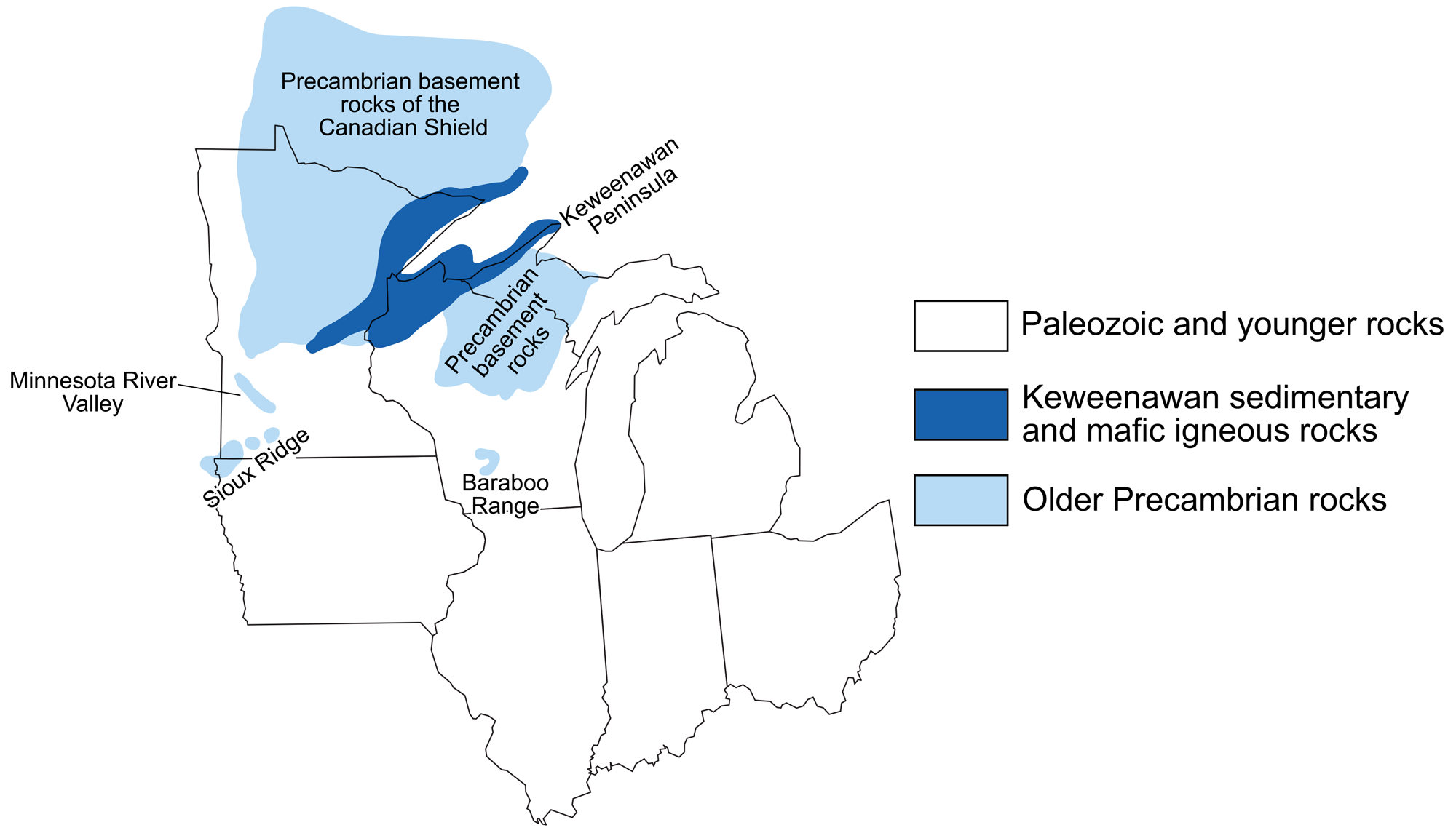
Precambrian outcrops in the Midwest. Adapted in a figure from W.I. Anderson, Iowa's Geological Past: Three Billion Years of Change.
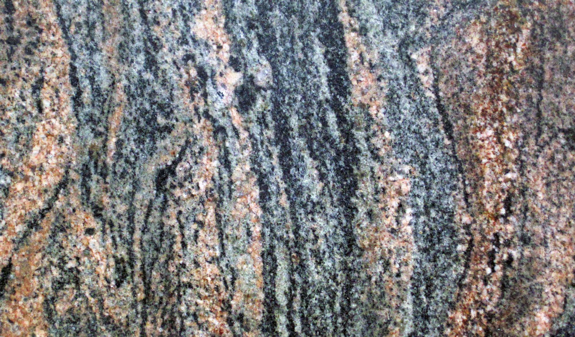
Detail of Archean (about 3.52 billion-year-old) Morton Gneiss from Morton, Minnesota. Photo by James St. John (flickr, Creative Commons Attribution 2.0 Generic license, image cropped and resized).
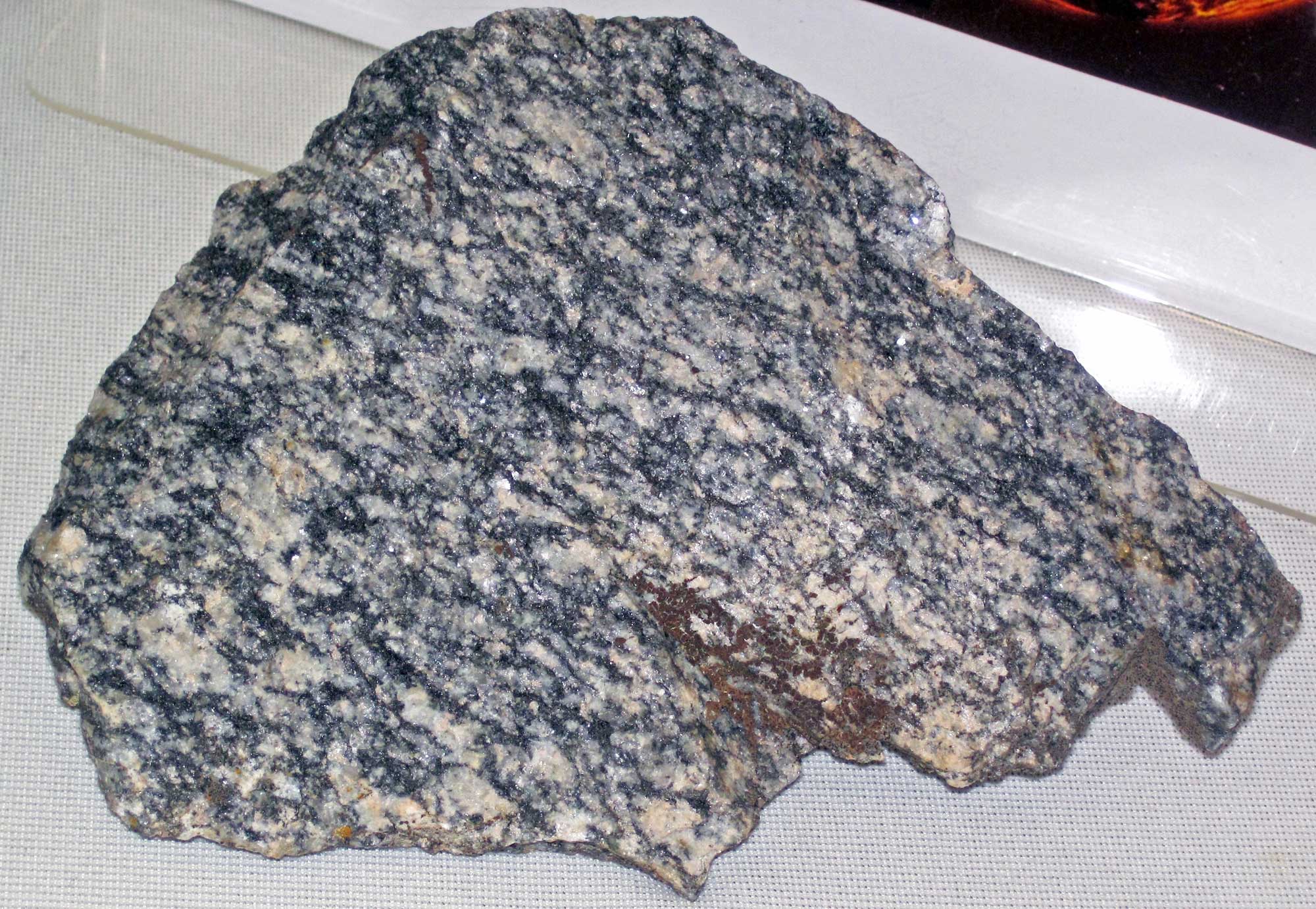
Detail of Archean (about 3.56 billion-year-old) Watersmeet Gneiss from Watersmeet, Michigan. Photo by James St. John (flickr, Creative Commons Attribution 2.0 Generic license, image cropped and resized).
Banded iron formations
The late Archean to Proterozoic of the Midwest was characterized by the deposition and presence of banded iron formations. With the evolution of photosynthetic organisms (still single-celled at this time), their waste product, oxygen, was released into the oceans and ultimately the atmosphere. The oxygen reacted and combined with dissolved iron particles to produce bands of iron oxides such as hematite and magnetite.
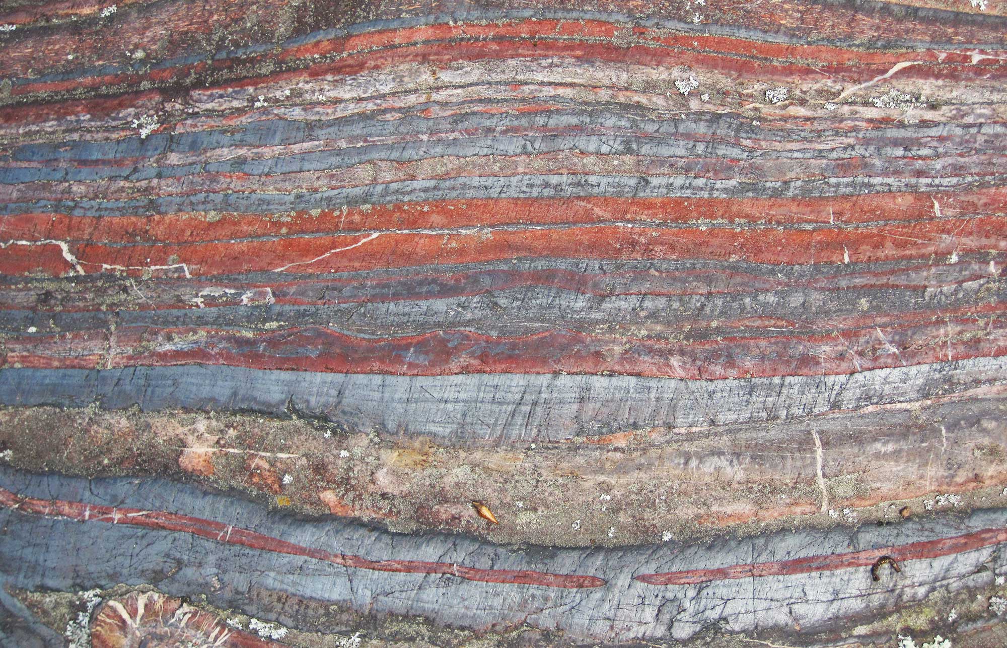
Banded iron formation (jaspilite) from the Soudan Iron-Formation, Minnesota, about 2.7 billion years old. Excerpt from original caption: "The light-colored layers are chert (= microcrystalline to cryptocrystalline quartzose sedimentary rock), the red layers are 'jasper' (= hematite-rich chert), and the silvery-gray layers are magnetite-chert." Information from and photo by James St. John (flickr, Creative Commons Attribution 2.0 Generic license, image cropped and resized).
Penokean Mountains
Between 1.8 and 1.9 billion years ago, an orogenic event produced the Penokean Mountains, which extended from Minnesota into northern Wisconsin and Michigan. The Penokean Orogeny occurred as the Pembine-Wausau island arc and Marshfield terrane collided from the south, increasing the size of the Superior landmass. Erosion of the Penokean Mountains led to deposits of sandstone along the margin of a shallow sea. Around 1.7 billion years ago, after millions of years of heat and pressure, this sandstone produced the metamorphic Sioux Quartzite of Minnesota and Iowa. The Baraboo Quartzite of the Devil’s Lake area in central Wisconsin also dates to this time.
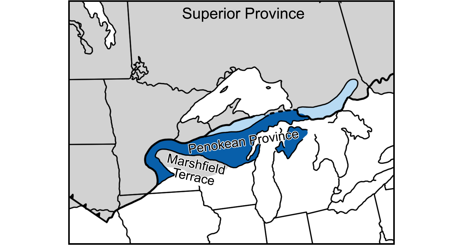
The accretion of the Pembine-Wausau island arc and the Marshfield terrane led to the Penokean Orogeny of the Proterozoic. Adapted from a figure in S.J. Whitmeyer and K. Karlstrom (2007) Geosphere 3(4): 220-259.
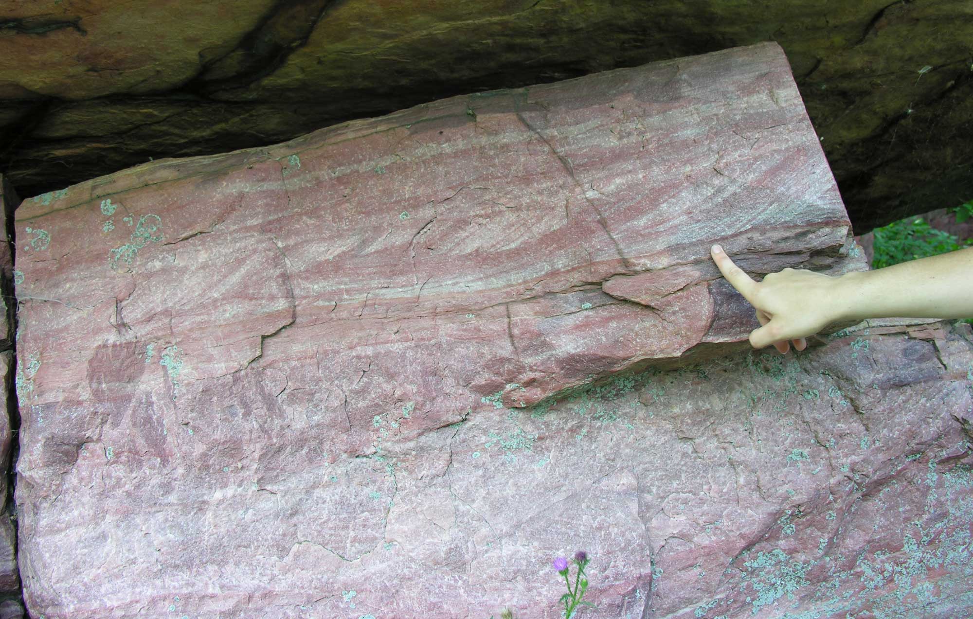
Sioux quartzite in Blue Mounds State Park, Minnesota. Photo by Awickert/Andrew Wickert (Wikimedia Commons, Creative Commons Attribution-ShareAlike 3.0 Unported license, image cropped and resized).
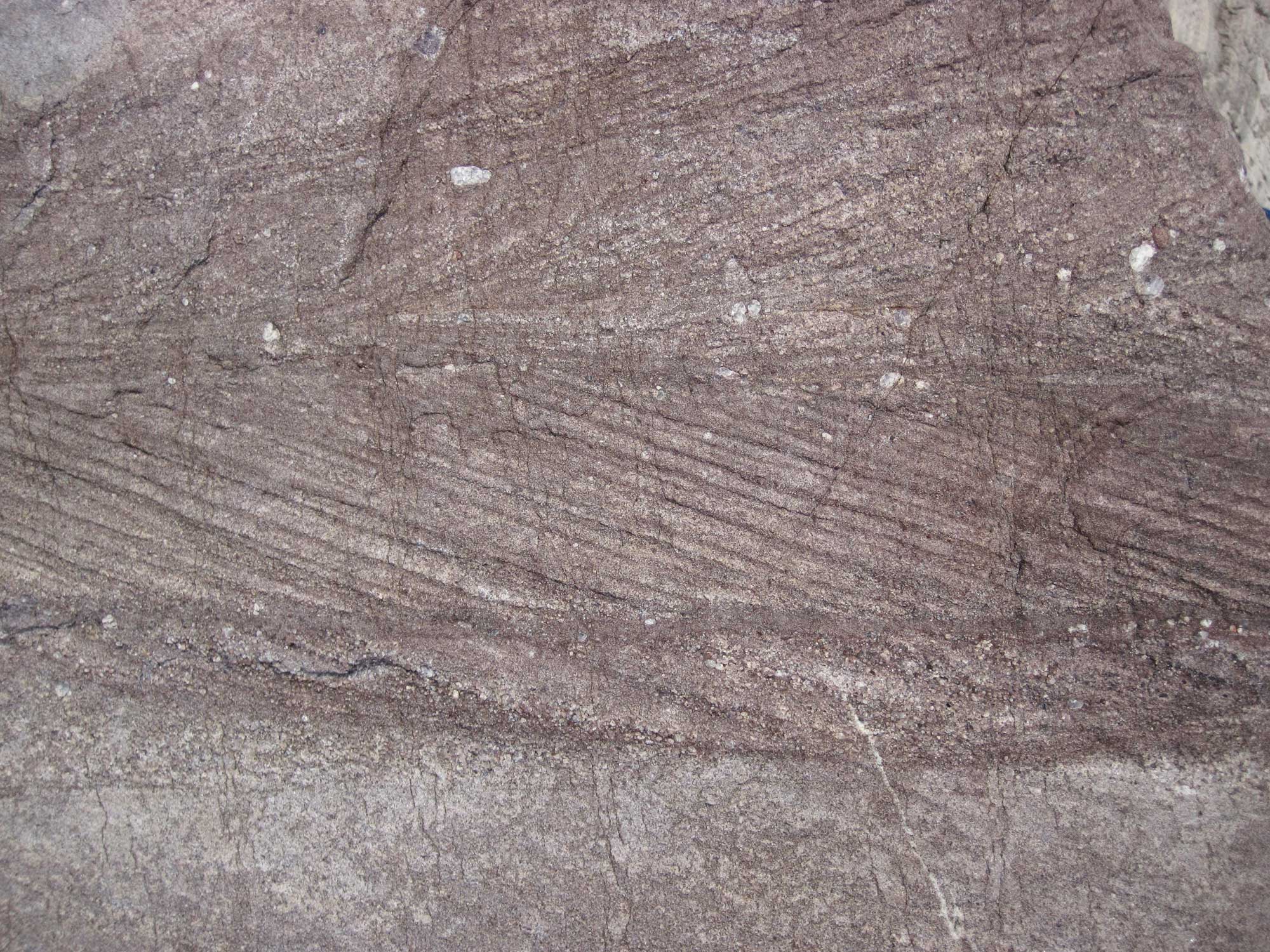
Baraboo Quartzite, Devil's Lake State Park, Wisconsin. Photo by James St. John (flickr, Creative Commons Attribution 2.0 Generic license, image resized).
Midcontinent Rift System (Keweenawan Rift)
Around 1.1 billion years ago, a rift valley called the Midcontinent Rift System (Keweenawan Rift) began to split North America apart. The Midcontinent Rift System extended from the eastern edge of modern-day Lake Superior to Kansas. Intense volcanism occurred along the rift, producing igneous deposits with a thickness of some 7.6 kilometers (25,000 feet). The spreading occurred for 20 million years, after which the rift zone began to sink and was gradually filled with sediment.
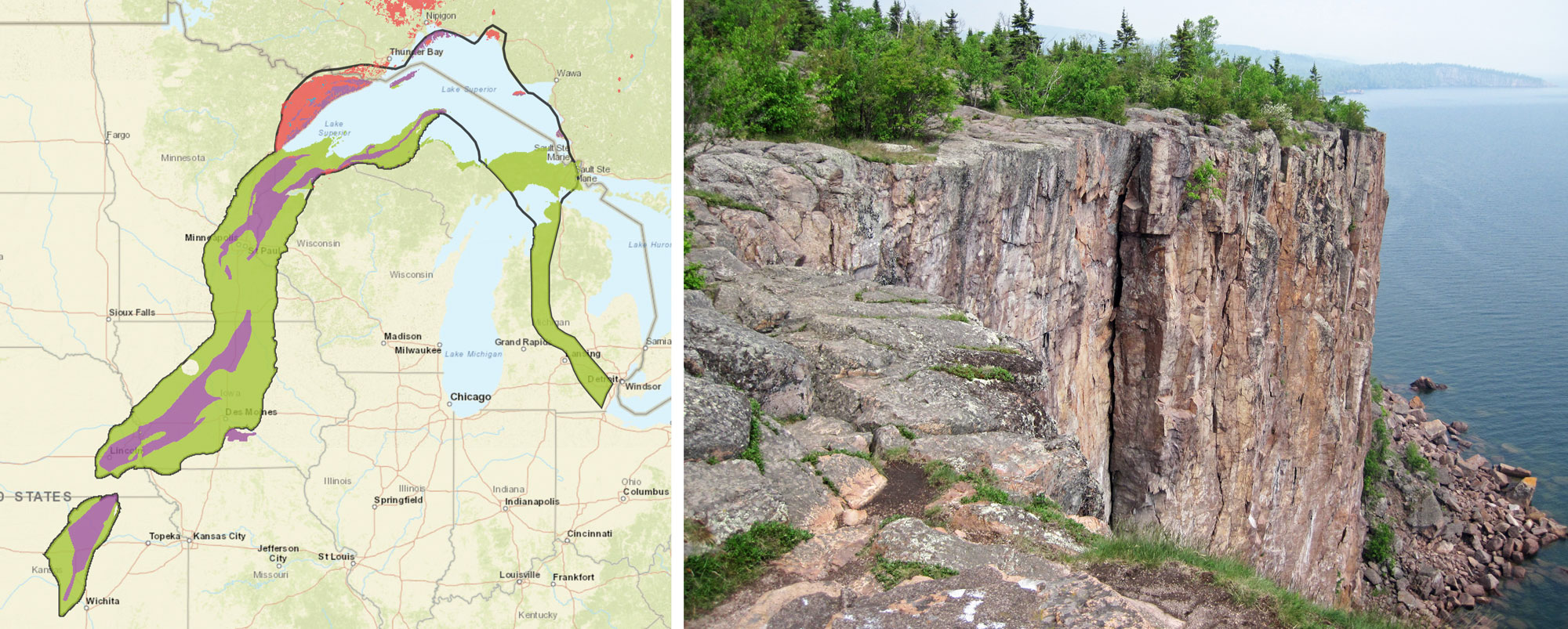
The Midcontinent Rift System. Left: Map showing the boundary of the Midcontinent Rift (black line) and the rocks types in it. Green = sedimentary rock; blue = metamorphic rock; purple = volcanic rock; pink = intrusive igneous rock. Map from USGS "Mineral Deposits of the Midcontinent Rift System" (U.S. government work/no other use policy found). Right: Palisade rhyolite (an extrusive igneous or volcanic rock), about 1.1 billion years old, shore of Lake Superior, northeastern Minnesota. Photo by James St. John (flickr, Creative Commons Attribution 2.0 Generic license, image cropped and resized).
Paleozoic (541 to 252 million years ago)
Overlying the older rock of the Canadian Shield, much of the remaining geologic history of the Midwest records the presence of shallow seas, the formation of the supercontinent Pangaea, and—most recently—the modern ice age.
Cambrian and Ordovician (541 to 444 million years ago)
Cambrian deposits are recorded in Wisconsin, Illinois, Minnesota, and Iowa. During this time, shallow seas covered much of the Midwest, with several transgression and regression episodes recorded as well. Nearly all of what would become North America (a continent called Laurentia) was located just south of the equator at the dawn of the Cambrian, and it drifted within the tropics for most of its existence.
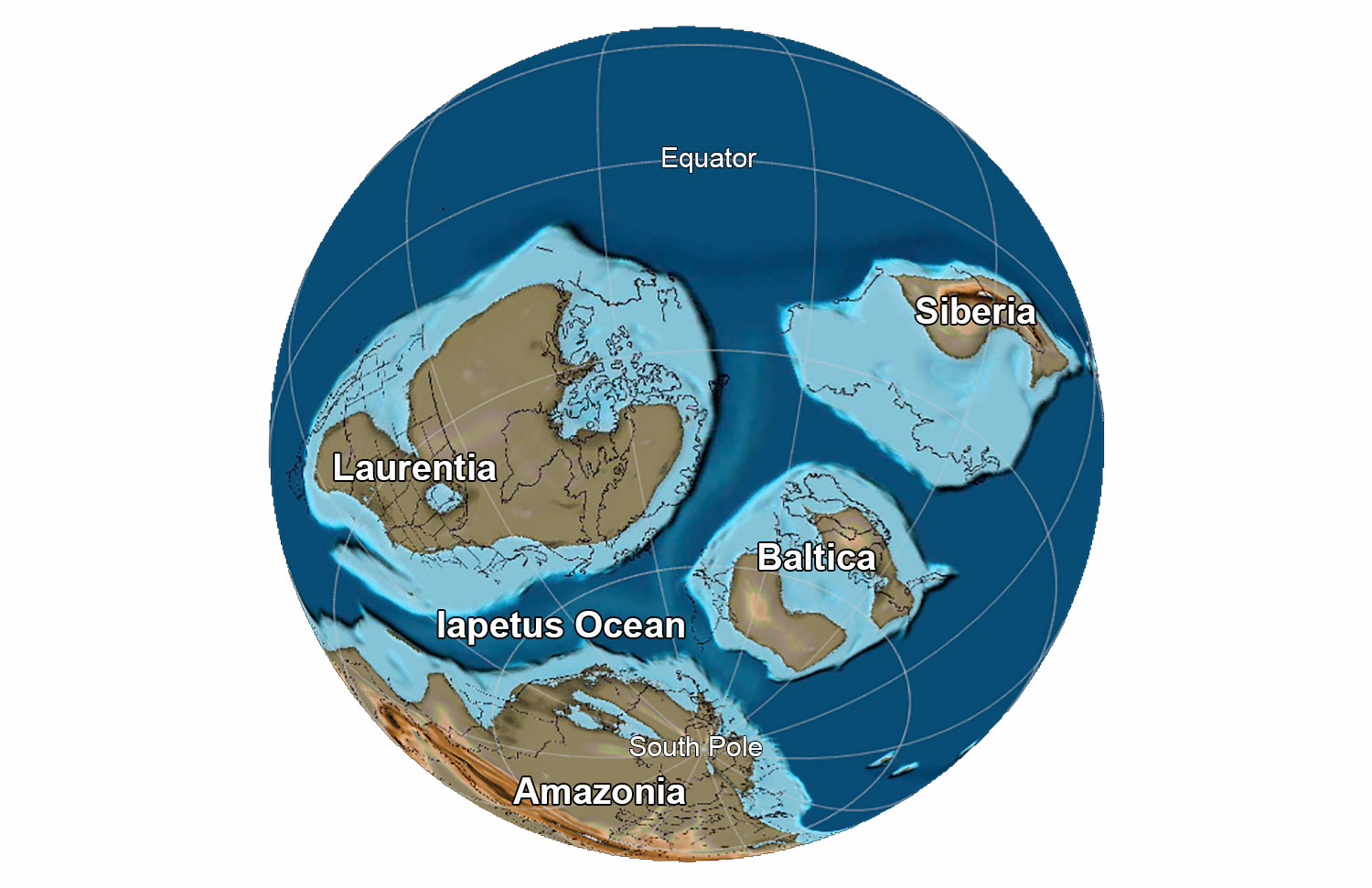
Earth at the end of the Precambrian, 565 million years ago. Laurentia is the name given to "proto-North America"; Baltica consists of modern northern European countries; Amazonia, which was part of Gondwana, includes much of modern Brazil. All of these continents were positioned south of the equator 565 million years ago. Reconstruction created using basemap from the PALEOMAP PaleoAtlas for GPlates and the PaleoData Plotter Program, PALEOMAP Project by C. R. Scotese (2016); map annotations by Jonathan R. Hendricks for PRI's Earth@Home project (CC BY-NC-SA 4.0 license).
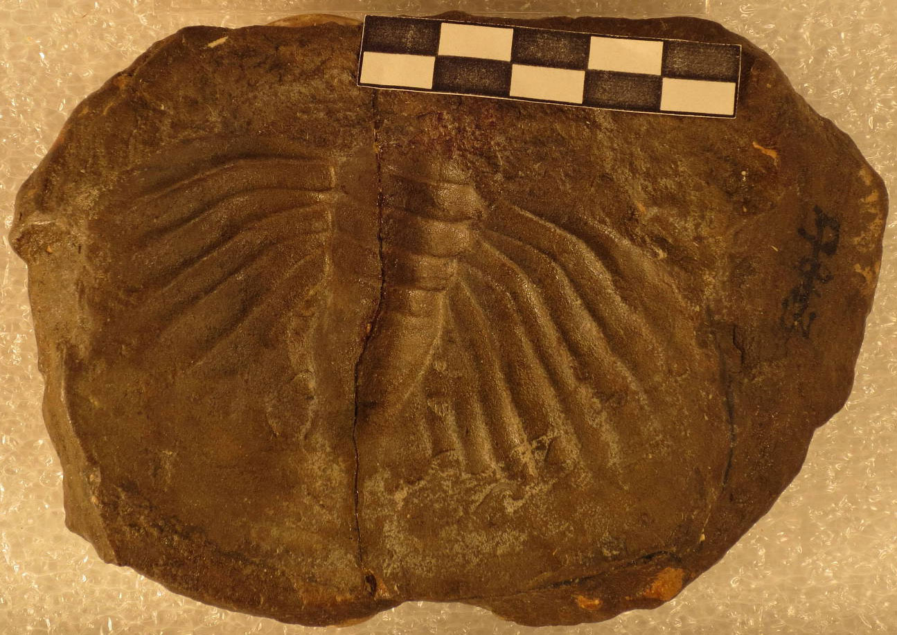
Trilobite pygidium (Dikelocephalus minnesotensis), Cambrian Trempealeau Formation, Washington County, Minnesota. Photo of USNM PAL 17863 by Department of Paleobiology (National Museum of Natural History, Smithsonian Institution, CC0/public domain).
During the middle of the Ordovician period, about 470 million years ago, the Iapetus Ocean began to close as Baltica (proto-Europe) approached the North American plate from the southeast. The intense pressure of the colliding plates and islands smashing into the side of North America caused its edge to crumple, crushing and folding it into mountains. This mountain-building event is called the Taconic Orogeny, and the resulting Taconic Mountains stretched from Newfoundland to Georgia, sharing roughly the same location and orientation of the Appalachian Mountains today, but with towering peaks in eastern Canada and New England.
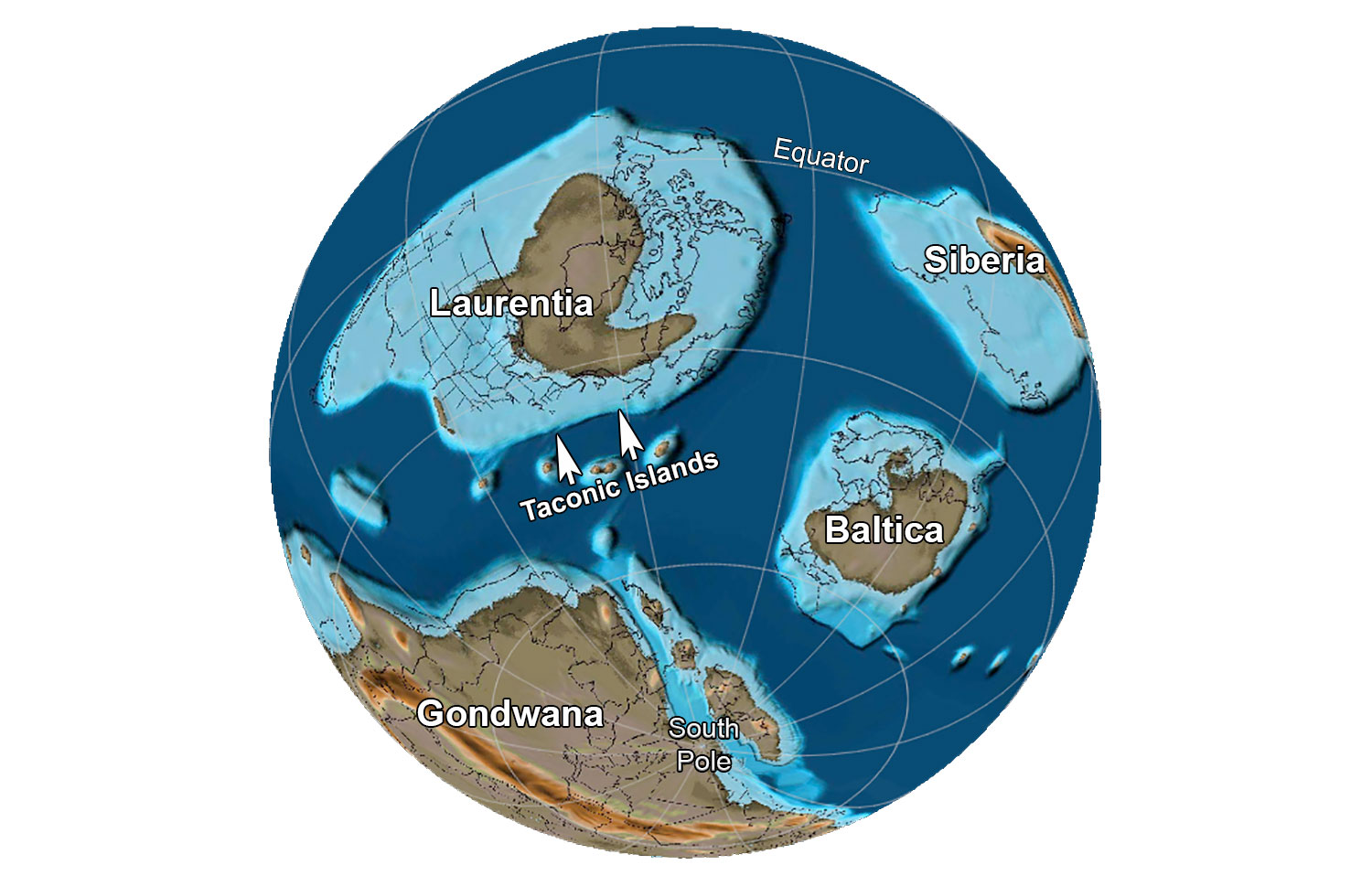
Earth 485 million years ago, at the beginning of the Ordovician Period. Laurentia is the name given to "proto-North America"; Baltica consists of modern northern European countries. Reconstruction created using basemap from the PALEOMAP PaleoAtlas for GPlates and the PaleoData Plotter Program, PALEOMAP Project by C. R. Scotese (2016); map annotations by Jonathan R. Hendricks for PRI's Earth@Home project (CC BY-NC-SA 4.0 license).
This folding propagated far to the west, forming waves parallel to the Taconic Mountains themselves that ran roughly southwest to northeast. Nearest the mountains, the crust warped downwards from central New York to central North Carolina, creating the Appalachian Basin. From western Ohio to Alabama, it was warped up into the Cincinnati Arch, and then down again further inland, creating the Michigan and Illinois basins. These formations are prominent features of Midwestern geology. The inland basins were flooded by the ocean for nearly all of their existence.
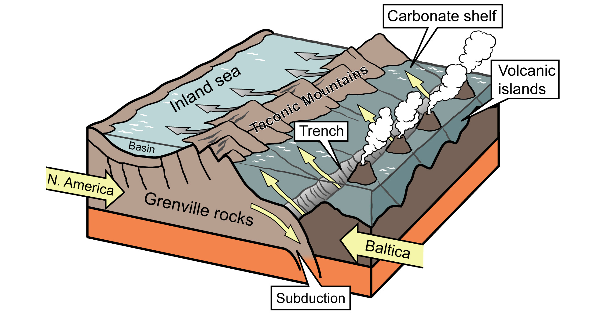
Volcanic islands formed where the plates were forced together as the Iapetus Ocean closed. The compression crumpled the crust to form the Taconic Mountains and a shallow inland sea farther to the west. Image modified from original by J. Houghton first published in The Teacher-Friendly Guide to the Earth Science of the Southeastern US, 2nd ed., edited by Andrielle N. Swaby, Mark D. Lucas, and Robert M. Ross (published by the Paleontological Research Institution) (CC BY-NC-SA 4.0 license).
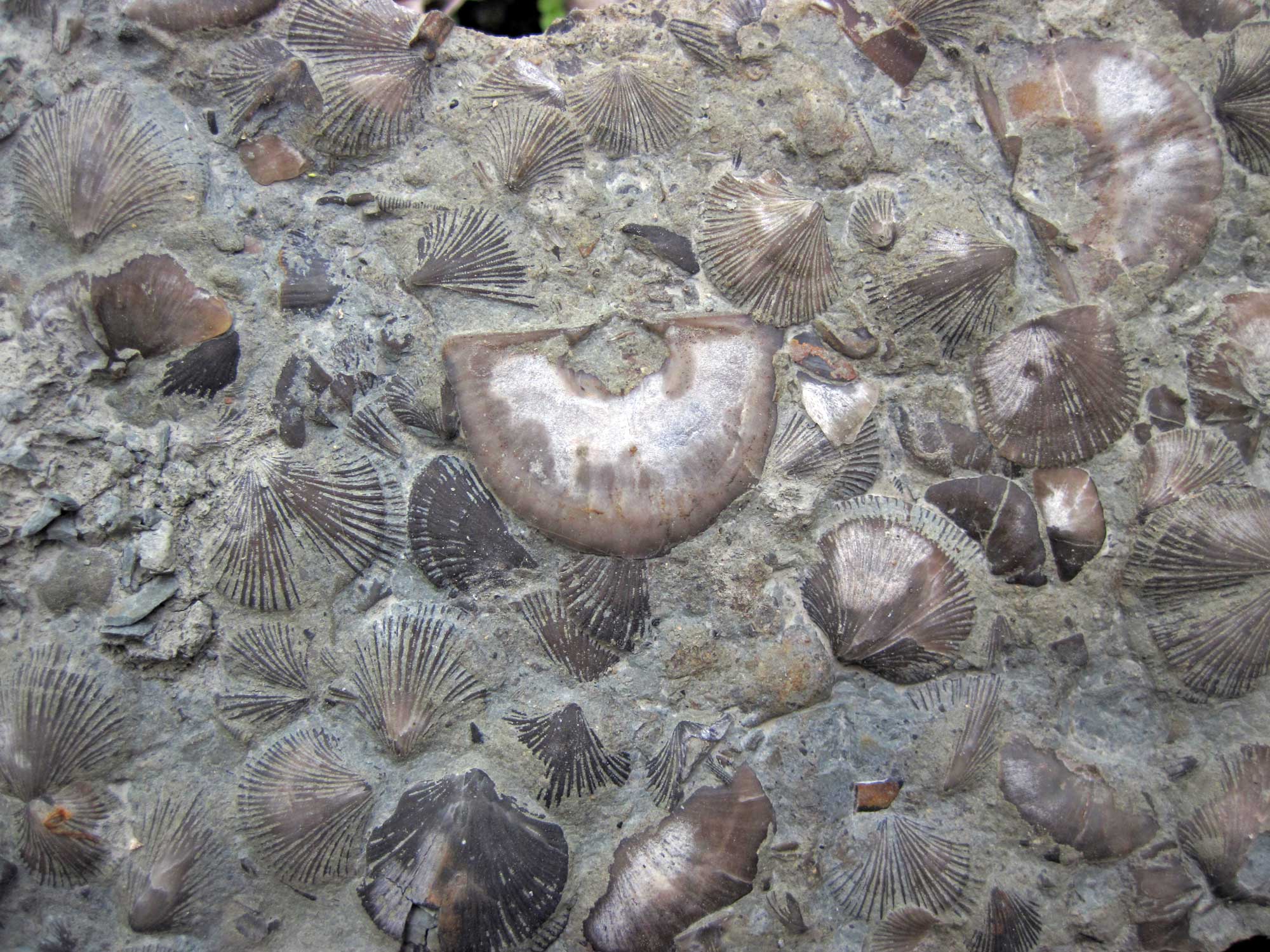
Brachiopods, Ordovician Waynesville Formation, Warren County, Ohio. Photo by James St. John (flickr, Creative Commons Attribution 2.0 Generic license, image resized).
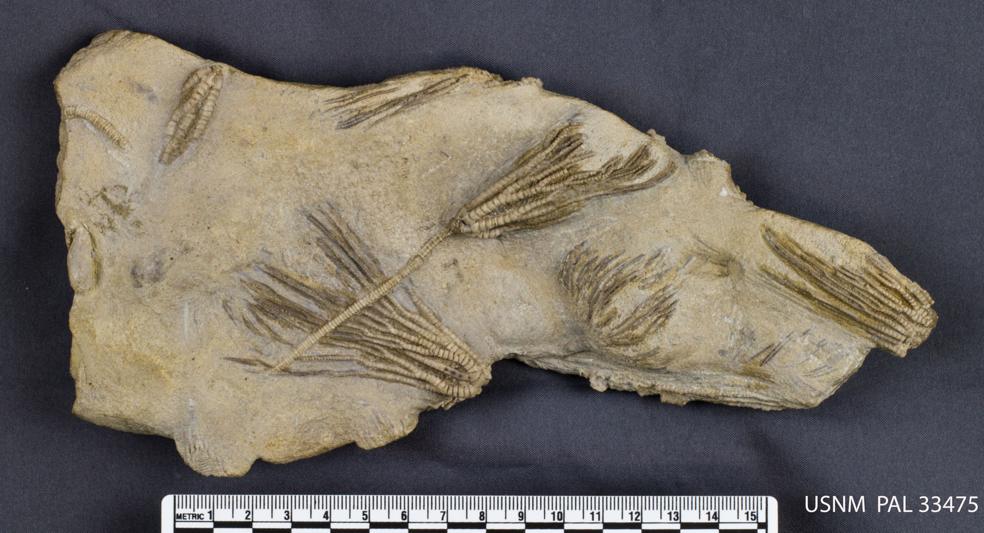
Crinoids (Iocrinus subcrassus) from the Ordovician McMillan Formation, Hamilton County, Ohio. Photo of USNM PAL 33475 by Bruce Martin (National Museum of Natural History, Smithsonian Institution, CC0/public domain).
Silurian to Mississippi (444 to 323 million years ago)
The mountain building ceased around the beginning of the Silurian, but the Taconic Mountains still played a major role in the formation of the Midwest. As sediment was eroded from the western side of the Taconic Mountains, deposits spread away, through the Northeast and Midwest, as far west as Wisconsin. Thousands of feet of this sediment built up on the floors of the seas that filled the Midwestern basins, and this sediment, along with the millions of generations of marine organisms that lived there, formed the Silurian and Devonian bedrock of much of the area.
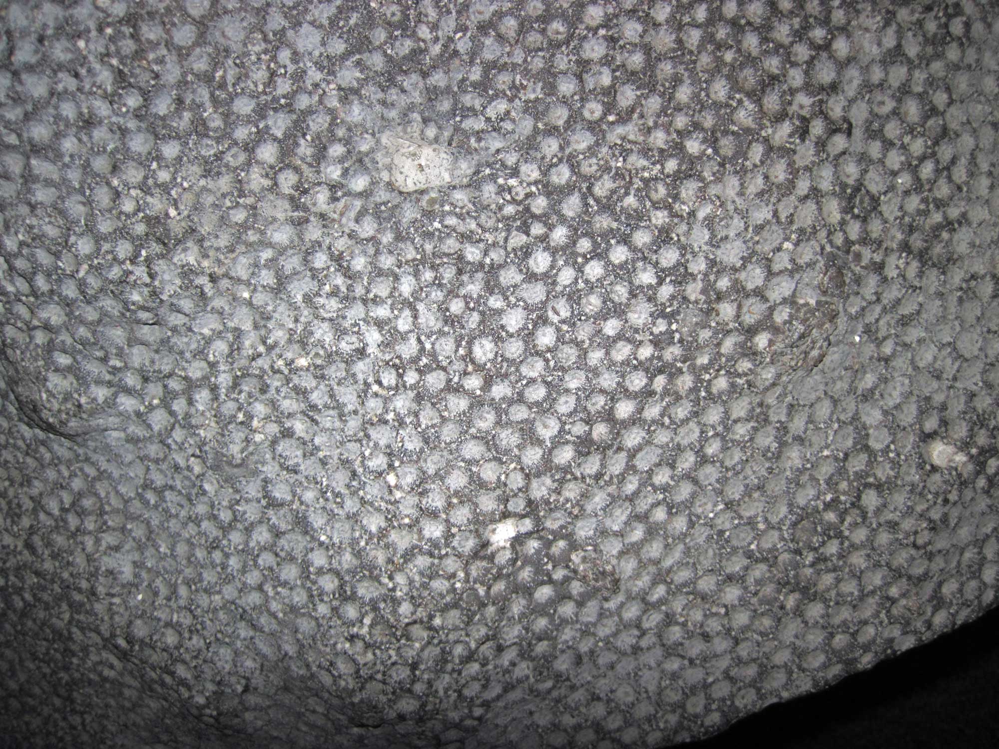
A bryozoan (Fistulipora neglecta), Silurian, Illinois. Photo by James St. John (flickr, Creative Commons 2.0 Generic license, image resized).
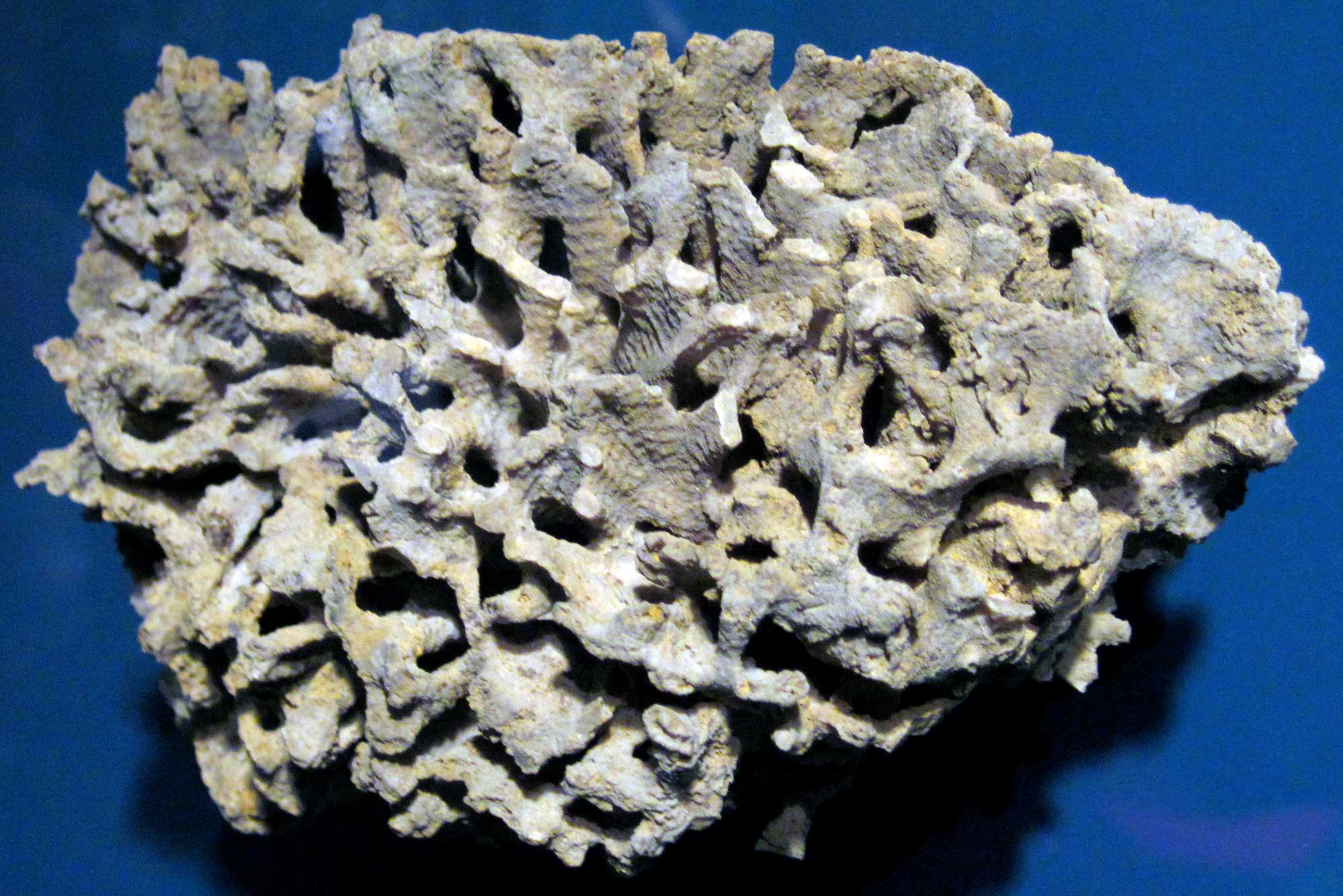
The colonial rugose coral Hexagonaria, Devonian, Michigan. Photo by James St. John (flickr, Creative Commons 2.0 Generic license, image resized).
For about 60 million years, the eastern margin of North America was relatively quiet. The subduction of the oceanic Iapetus plate caused volcanic eruptions that occasionally spread ash over the Midwest, but for the most part, the Taconics were slowly eroding. Finally, Baltica collided with North America near the end of the Devonian period, around 380 million years ago, and mountain-building began again, creating the Acadian Mountains. The Acadian Mountains effectively replaced the Taconics, creating a massive range that was similar in location and extent.
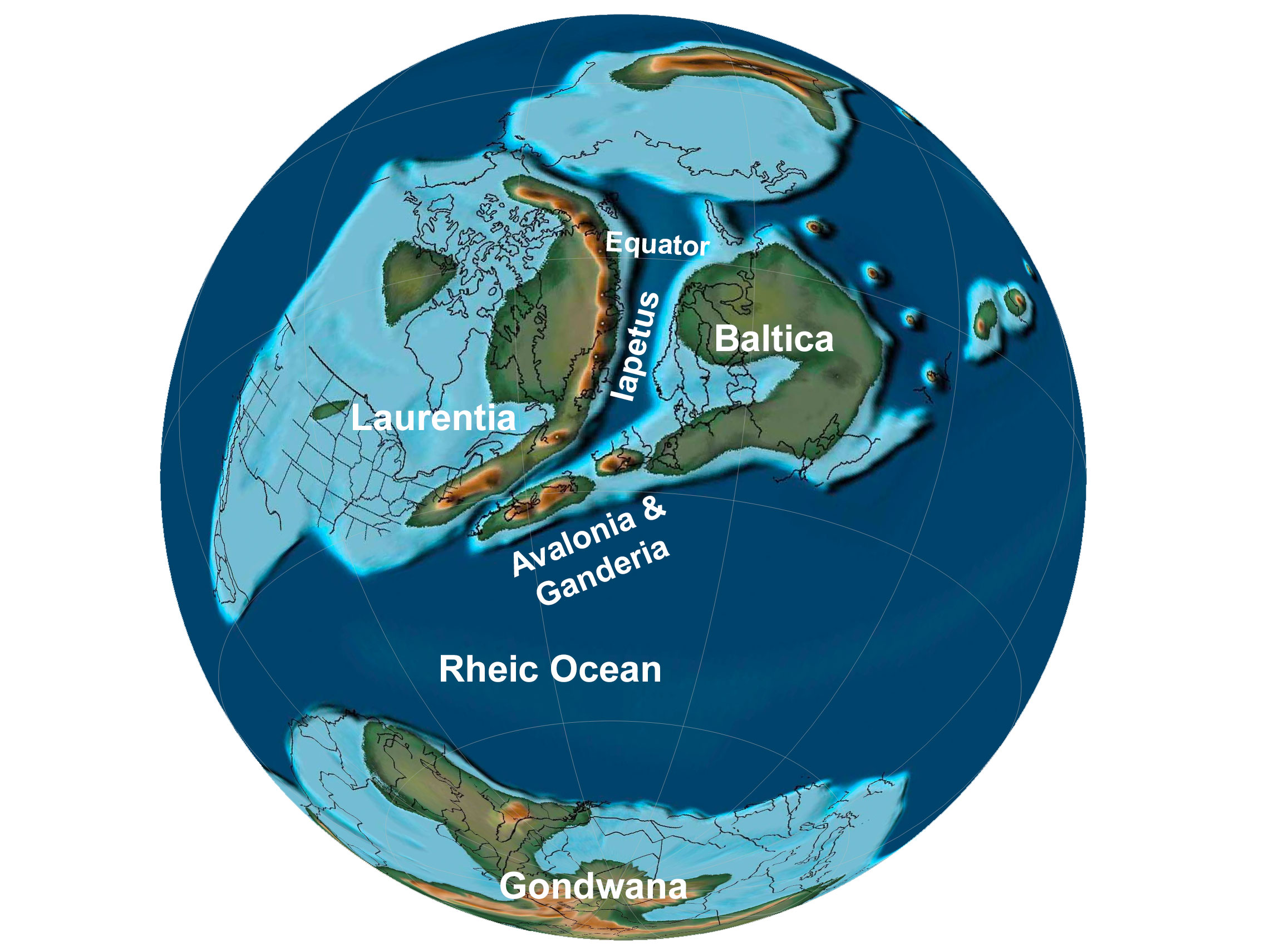
Earth 430 million years ago, during the middle of the Silurian period. The Iapetus Ocean was closing as Baltica, Avalonia, and Ganderia neared the margin of Laurentia. Laurentia is the name given to "proto-North America"; Baltica consists of modern northern European countries. Reconstruction created using basemap from the PALEOMAP PaleoAtlas for GPlates and the PaleoData Plotter Program, PALEOMAP Project by C. R. Scotese (2016); map annotations by Elizabeth J. Hermsen for PRI's Earth@Home project (CC BY-NC-SA 4.0 license).
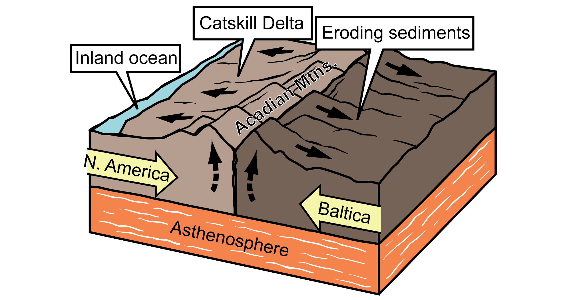
North America and Baltica finished colliding in the mid-Devonian, crumpling the crust to form the Acadian Mountains. Sediments that was eroded from the highlands formed the Catskill Delta. Image modified from original by J. Houghton first published in The Teacher-Friendly Guide to the Geology of the Northeastern U.S. by Jane Ansley (published by the Paleontological Research Institution) (CC BY-NC-SA 4.0 license).
Just as in the Taconic mountain-building period, compression from the Acadian continental collision warped the crust downward, reinforcing the inland seas. Sediments eroding from the mountains formed the Catskill Delta, creating a new wedge of sediments stretching into a shallow inland sea; the Devonian and Mississippian rocks of Ohio are evidence of this event.
At the time of the Acadian mountain building and subsequent erosion during the Devonian, the Midwest was located at the Equator and experienced a tropical climate. Baltica and North America were united as one larger landmass. Africa, South America, India, Australia, Antarctica, and Florida formed a second continent—Gondwana—in the southern hemisphere.
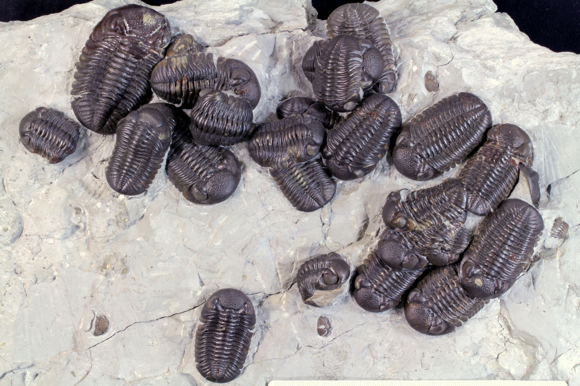
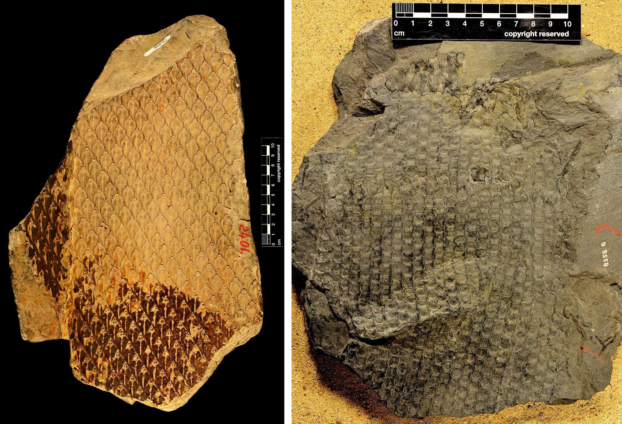
Trilobites (Phacops) from the Devonian Silica Shale, Ohio. Photo of USNM PAL 482068 by Michael Brett-Surman (National Museum of Natural History, Smithsonian Institution, CC0/public domain).
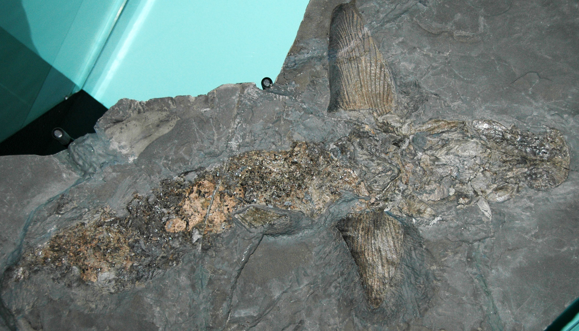
An ancient shark (Cladoselache fyleri) Devonian Ohio Shale, Cuyahoga County, Ohio. Photo by James St. John (flickr, Creative Commons Attribution 2.0 Generic license, image resized).
Pennsylvanian to Permian (323 to 252 million years ago)
During the Carboniferous, the collision of North America with Gondwana was the genesis of Pangaea. This event also resulted in the formation of both the Appalachian Mountains and, in Arkansas and Oklahoma, the Ouachita Mountains.
During the Pennsylvanian to Permian, sea levels began to fluctuate and ultimately fall. Regression of the sea was caused by a combination of glaciation at the South Pole and the forces of mountain building. Along the margins of the retreating sea, enormous coastal swamps formed. These swamps extended from modern Pennsylvania to Alabama and inland as far as Ohio, Indiana, Illinois, and Kansas. They were dominated by strange trees related to modern clubmosses and horsetails. When the vegetation in the swamps died, it fell into stagnant, oxygen-poor water. The lack of oxygen in the water slowed decomposition, forming huge deposits of peat. Sediment covered these deposits, compressing and ultimately metamorphosing them into some of the largest coal beds in the world. The extensive coal beds in North America and western Europe give the Carboniferous period its name.
The burial of so much carbon lowered the amount of carbon dioxide (CO2) in the Earth's atmosphere, and the abundant plant life raised global oxygen levels. Global temperatures continued to fall, accelerating glaciation in the southern hemisphere and lowering sea level worldwide. Ultimately, the interior seaways regressed from the Midwest, which is why there is no marine sediment younger than Pennsylvanian in age across this area of North America until the development of the Western Interior Seaway in the Cretaceous.
Scale trees (Lepidodendrales), an extinct group of lycophytes, Carboniferous. The "scales" forming the patterns on the trunks and branches of these trees are actually leaf cushions, scars left behind after leaves were shed. Left: Lepidodendron (YPM PB 035396), Orange County, Indiana. Right: Sigillaria elegans (YPM PB 035538), Summit County, Ohio. Photos by Robert Swerling (Yale Peabody Museum of Natural History/YPM on GBIF.org, CC0 1.0 Universal/public domain dedication).
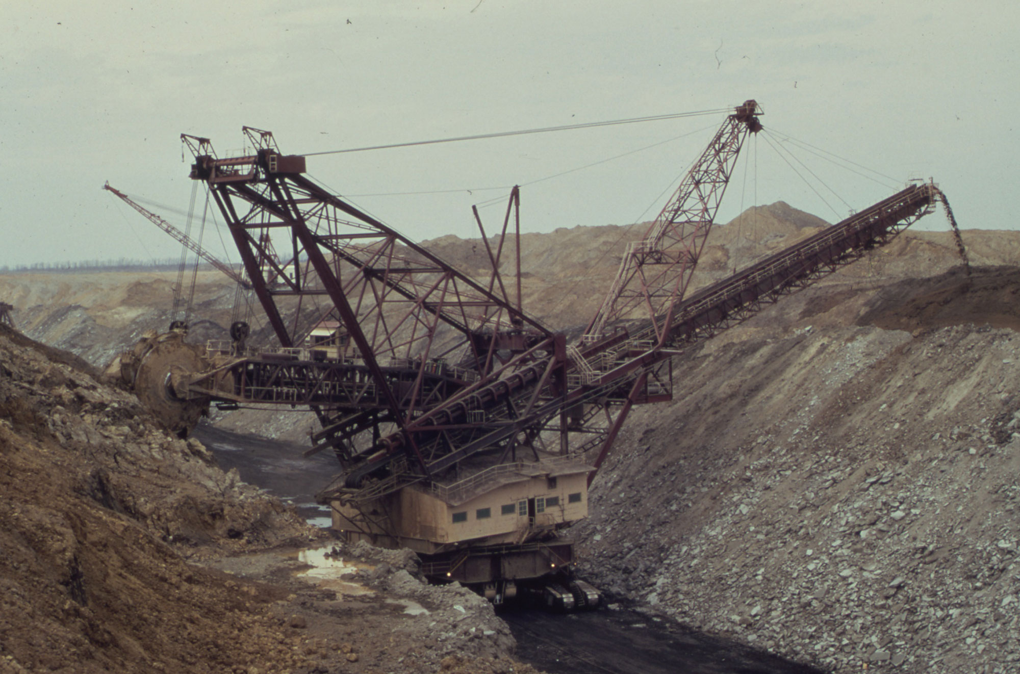
Strip mining coal, Fulton County, Illinois, 1973. Photo by Arthur Greenburg (EPA, National Archives and Records Administration, via Wikimedia Commons, public domain).
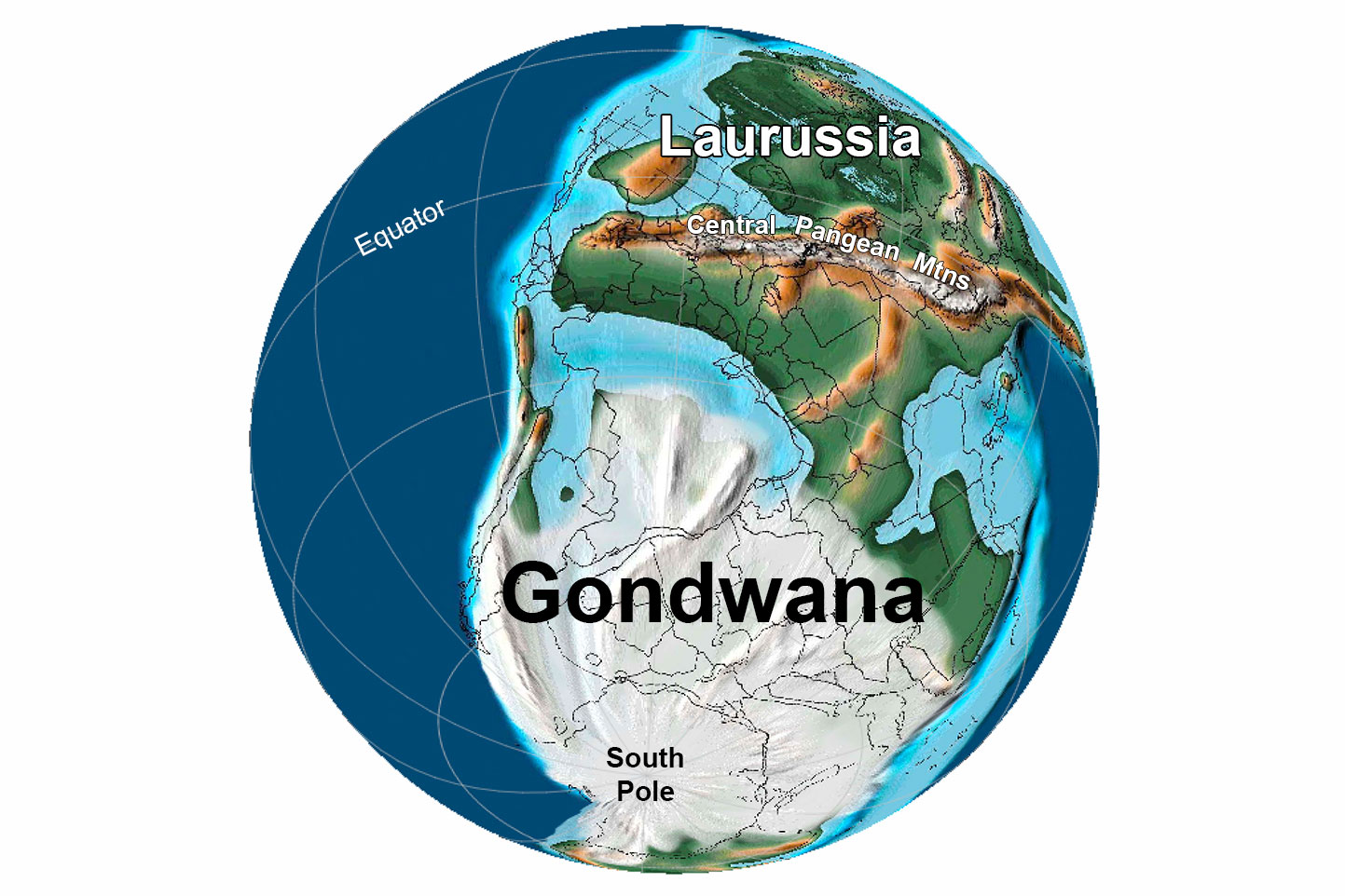
Earth 300 million years ago, during the end of the Carboniferous Period (Pennsylvanian). Pangaea was completed when North America finally collided with Gondwana. "Laurussia" is the landmass including ancient North America, and the Central Pangean Mountains are, in part, the ancestral Appalachian Mountains. Reconstruction created using basemap from the PALEOMAP PaleoAtlas for GPlates and the PaleoData Plotter Program, PALEOMAP Project by C. R. Scotese (2016); map annotations by Jonathan R. Hendricks & Elizabeth J. Hermsen for PRI's Earth@Home project (CC BY-NC-SA 4.0 license).
Mesozoic (252 to 66 million years ago)
In the Midwest, Mesozoic-aged rocks are preserved primarily in Minnesota, Iowa, and, to a lesser extent, in Illinois. For the remainder of the Midwest, the Mesozoic was a time of erosion and very little deposition.
The rocks that do exist were deposited mainly during the Cretaceous. At that time, North America was roughly divided into thirds: a western portion, an eastern portion, and a vast seaway inundating the center. This seaway stretched from Utah to the western edge of the Midwest and connected the Gulf of Mexico to the Arctic Ocean. Deposits in western Minnesota and Iowa contain a variety of Cretaceous creatures that lived near the shores of the Western Interior Seaway. The early Cretaceous was the first time during the Phanerozoic that the Midwest was north of the tropics, approaching its current position.
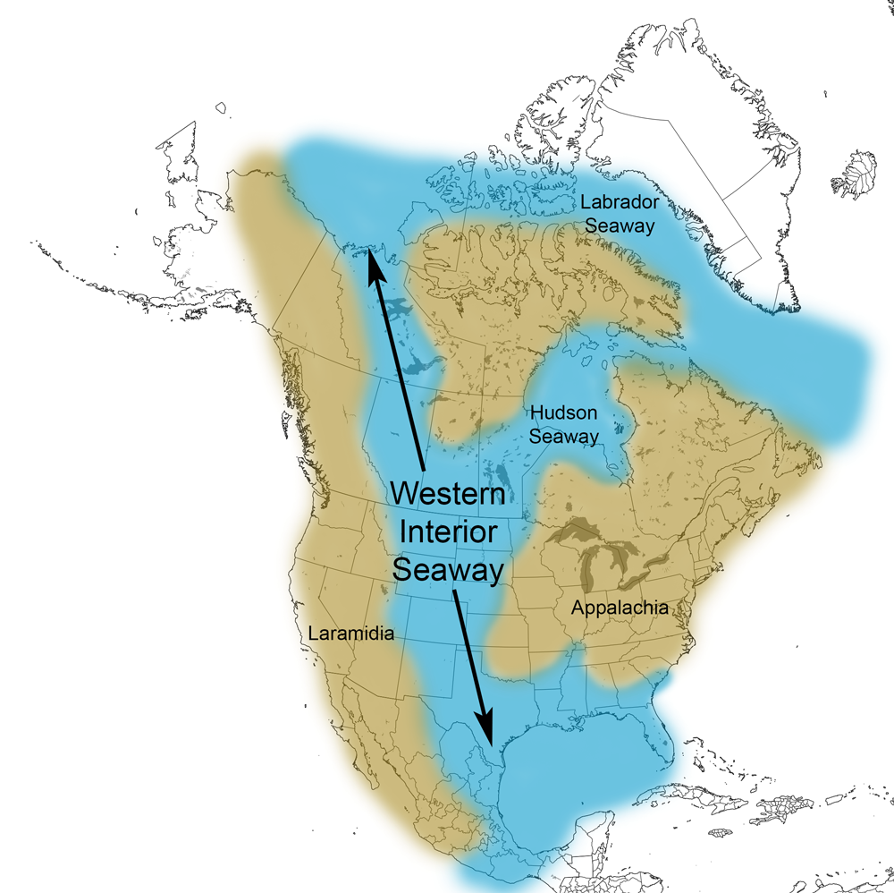
Extent of the Western Interior Seaway during the Cretaceous Period. Image from Cretaceous Atlas of Ancient Life: Western Interior Seaway (Creative Commons Attribution-NonCommercial-ShareAlike 4.0 International license).
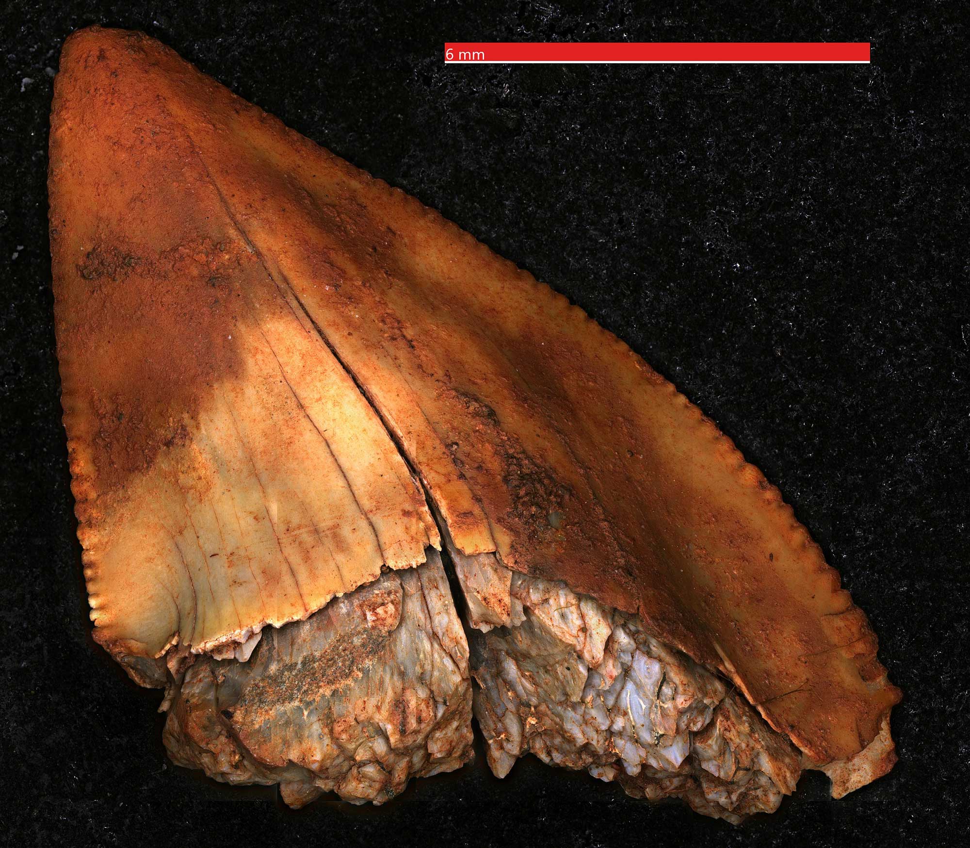
Crow shark tooth (Squalicorax), Late Cretaceous Coleraine Formation, Calumet, Minnesota. Photo by Rylan Bachman (Wikimedia Commons, Creative Commons Attribution 4.0 International license, image resized).
Quaternary (2.6 million years ago to present)
At the start of the Quaternary period, about 2.6 million years ago, continental ice sheets began to form in northernmost Canada. Throughout this period, the northern half of North America has been periodically covered by continental glaciers.
The Quaternary period is divided into two epochs: the Pleistocene and Holocene. During the Pleistocene, the ice sheets advanced south and retreated north several dozen times. The Holocene Epoch is the most recent (and current) period of retreat, called an interglacial interval. The most recent glacial advance in North America reached its maximum extent 21,000–18,000 years ago, while the beginning of the Holocene is considered to be 11,700 years ago, or about 9,700 BCE.
The landscape of the Midwest has been heavily influenced and shaped by the advance and retreat of these glaciers, with the surface of every state shaped by the forces of the moving ice that scraped loose rock, gouged the bedrock beneath, and deposited sediment and water as the ice advanced and retreated.
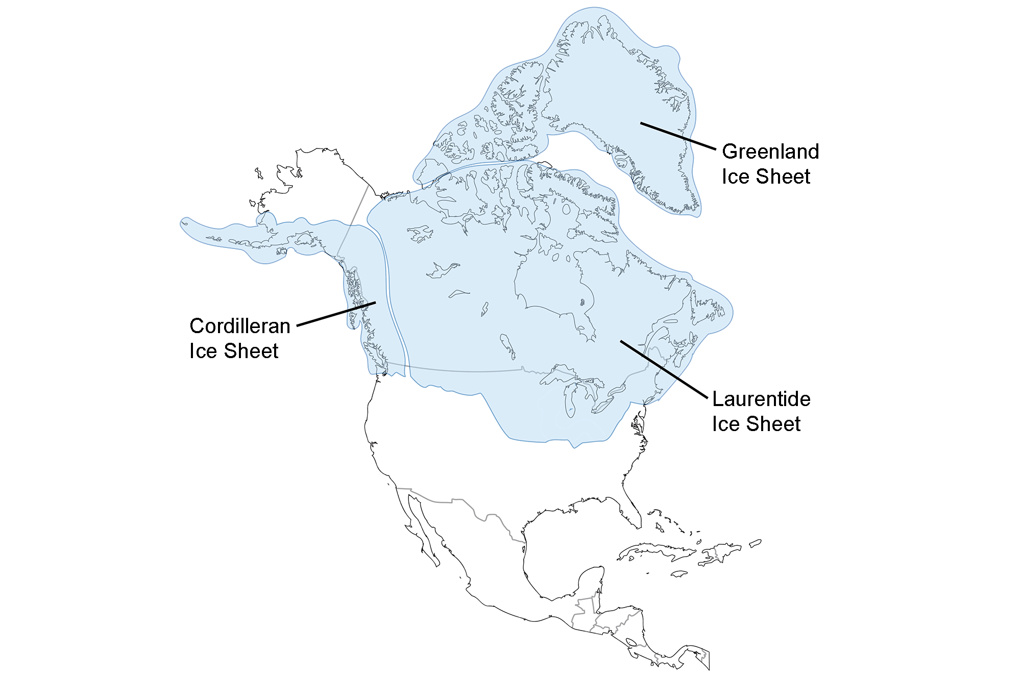
Extent of glaciation over North America at the Last Glacial Maximum. Image adapted from map by the USGS (public domain).
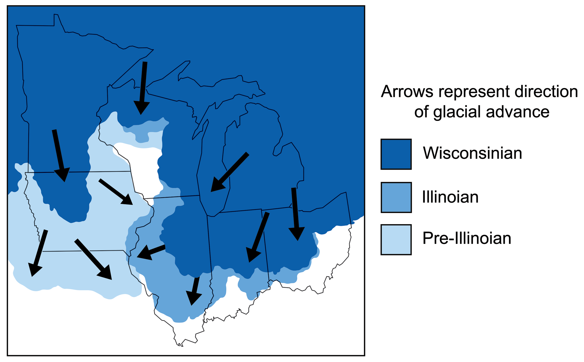
Map of the midwestern states showing Pleistocene glaciations. Each glacial advance differed slightly and left different sets of deposits. Adapted from figures by C.L. Matsch and USGS.
The Great Lakes of the Midwest and Northeast were formed during the last great glacial advance some 18,000 years ago. The broad, deep basins of the Great Lakes were flooded as the glaciers receded. Glacial meltwater poured into these basins, and the ice blocked the drainage that would eventually flow to the northeast via the St. Lawrence River. Once this path was available, the lakes gradually dropped to their current levels.
The ice age continues today, but the Earth is in an interglacial stage, since the ice sheets have retreated for now. The glacial-interglacial cycling of ice ages predicts that the world will return to a glacial stage in the future, but the impacts of human-induced climate change might radically shift the direction of these natural cycles.
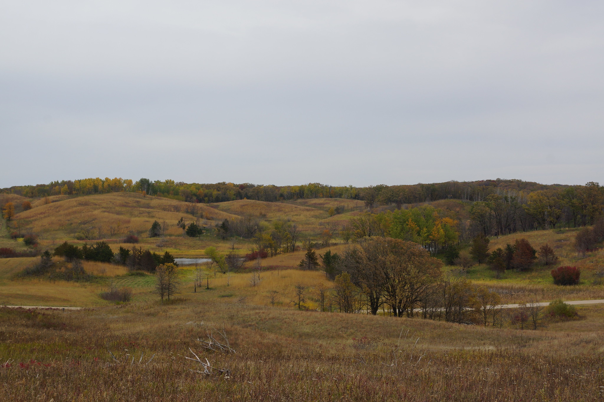
Landscape along the Glacial Ridge Trail, Minnesota, 2017. The landscape in this region is shaped by deposits of the Alexandria Glacial Moraine Complex, and includes eskers, kettles, and kames. Photo by Greg Gjerdingen (flickr, Creative Commons Attribution 2.0 Generic license).
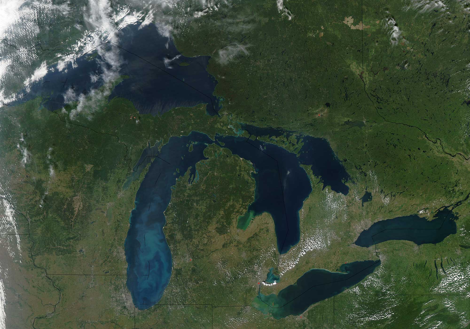
Satellite image of the Great Lakes region of North America. Photo by Jeff Schmaltz, MODIS Rapid Response Team, NASA/GSFC (NASA Visible Earth, used following NASA's image use policy).
Resources
Earth@Home: Here on Earth: Introduction to Plate Tectonics: https://earthathome.org/hoe/plate-tectonics