

Snapshot: Overview of the topography of the Colorado Plateau region of the southwestern United States.
Topics covered on this page: Overview; Canyon Lands; Grand Canyon; Uinta and Piceance Basins; Navajo and Datil Sections; Resources.
Credits: Most of the text of this page is derived from "Topography of the Southwestern US" by Bryan L. Isacks, Richard A. Kissel, and Warren D. Allmon, chapter 4 in The Teacher-Friendly Guide to the Earth Science of the Southwestern US, edited by Andrielle N. Swaby, Mark D. Lucas, and Robert M. Ross (published in 2016 by the Paleontological Research Institution). The book was adapted for the web by Elizabeth J. Hermsen and Jonathan R. Hendricks in 2021–2022. Changes include formatting and revisions to the text and images. Credits for individual images are given in figure captions.
Updates: Page last updated April 8, 2022.
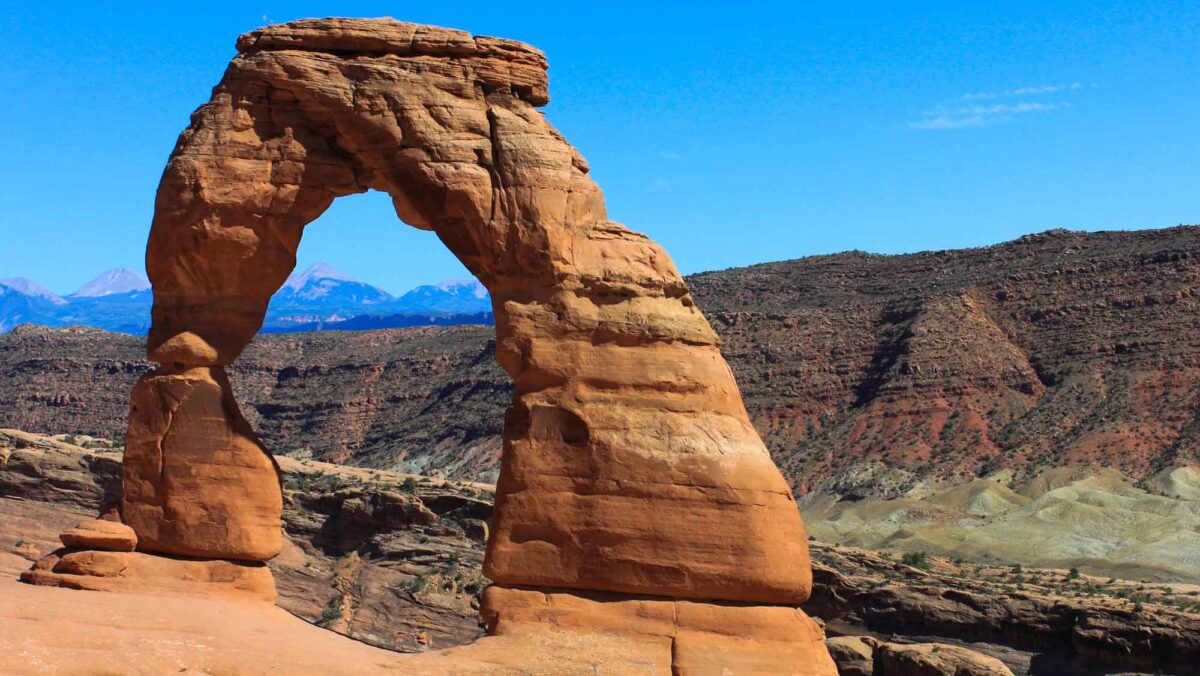
Image above: Delicate Arch, Arches National Park, Utah. The La Sal Mountains are visible in the background. Photograph by "Jefftheman45" (Flickr; Creative Commons Attribution-NonCommercial-ShareAlike 2.0 Generic license; image cropped and resized).
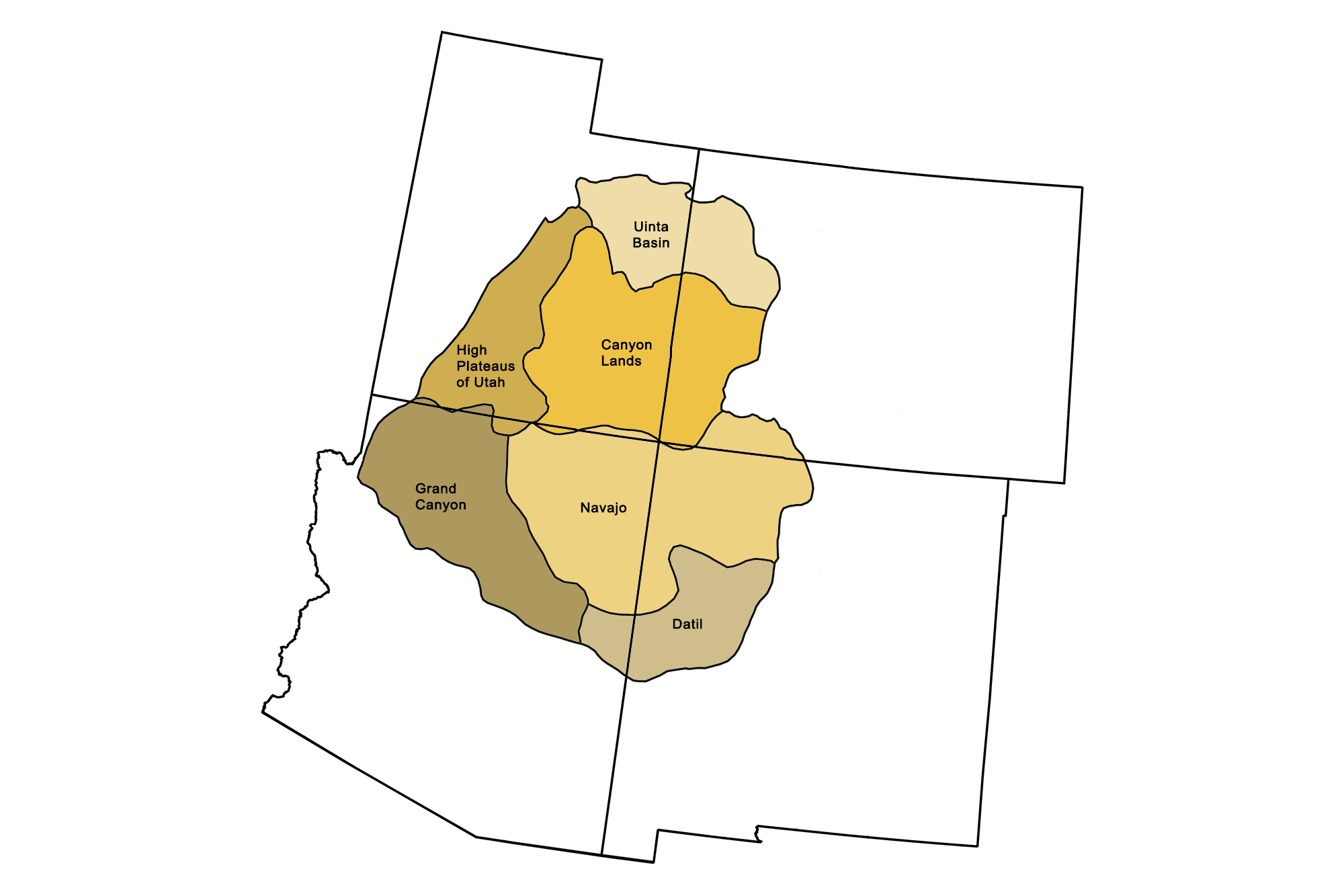
Physiographic subdivisions of the Colorado Plateau. Image by Jonathan R. Hendricks for the Earth@Home project.
Overview
The Colorado Plateau covers an area of approximately 335,000 square kilometers (130,000 square miles) close to the center of the Southwest. It is the one region located in all four states, whose borders intersect at the “four corners” near the center of the plateau. It is bordered by the Colorado Rockies in the northeast, the Uinta Mountains in the northwest, and the Basin and Range (including the Rio Grande Rift) along the west, southwest, and southeast. Although the Colorado Plateau is largely semi-arid, the Colorado River and its tributaries access considerable runoff from snowmelt and rain in the Rocky Mountains to the north and east. These rivers and streams have carved numerous canyons throughout the region, culminating in the grandest of canyons on Earth. The Colorado River defines the lowest elevation on the plateau, near 330 meters (1100 feet) where it exits into Lake Mead, but most of the plateau is higher, with an average elevation of approximately 2000 meters (6500 feet) and elevations mainly in the range of 1200 to 2400 meters (4000 to 8000 feet). Higher elevations up to 3300 meters (11,000 feet) are located in the High Plateaus of Utah and the volcanic fields of the Navajo section.
The outstanding and unusual topographic scenery of the Colorado Plateau is a main theme for the 8 National Parks and 25 National Monuments located there.
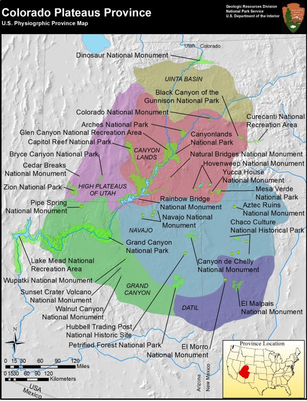
Locations of some national parks and monuments in the Colorado Plateau. Image by the National Park Service (public domain).
Initially, this topography was shaped when the Laramide Orogeny deformed the thick sequence of Paleozoic and Mesozoic strata that had previously been lying flat near sea level beneath the Western Interior Seaway. The broad arches (anticlines), monoclines, domes, and basins formed by the Laramide Orogeny are beautifully preserved in the plateau as textbook examples of geologic structures. During the Cenozoic, the margins of the plateau were also affected by Basin and Range faulting and magmatism. Second, erosion of the plateau, especially during the late Cenozoic, has mostly occurred in a semi-arid environment. This has allowed a dramatic display of both the unique forms of semi-arid erosion (driven by flash floods, frost, and intermittent rain) and the structural features generated by past geologic deformation.
Canyon Lands
Including: Canyonlands National Park, Zion National Park, Bryce Canyon, Antelope Canyon, and Capitol Reef National Park.
The Canyon Lands (or Canyonlands), encompassing the central portion of the Colorado Plateau, are a scenic wonderland where erosion has sculpted some of the most beautiful and geologically fascinating landscapes on Earth. The semi-arid climate prevailing over the plateau during much of the Cenozoic has interacted with the area's mildly deformed layer cake of sedimentary strata to produce fantastic erosional forms. The strata's variation in thickness and erodibility led to the formation of plateaus, mesas, buttes, and chimneys, all fringed by cliffs or a staircase of cliffs and slopes topped with more resistant caprocks. The slopes between cliffs are formed from eroded rock debris. As plateaus continue to erode, they leave behind progressively smaller remnants, including arches, natural bridges, windows, tents, spires, needles, hoodoos, balanced rocks, fins, and pinnacles that appear in stunning displays.
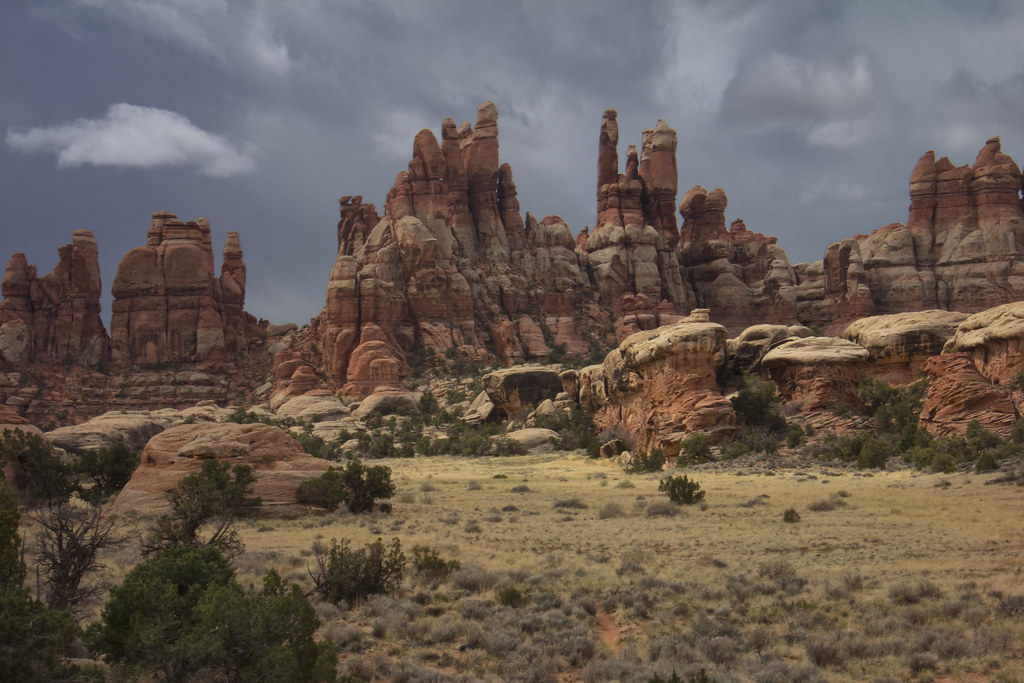
Weathered rock spires in the Needles district of Canyonlands National Park, Utah. Photograph by M. Orchard, Chesler Park (Flickr; Creative Commons Attribution-NonCommercial-NoDerivs 2.0 Generic license).
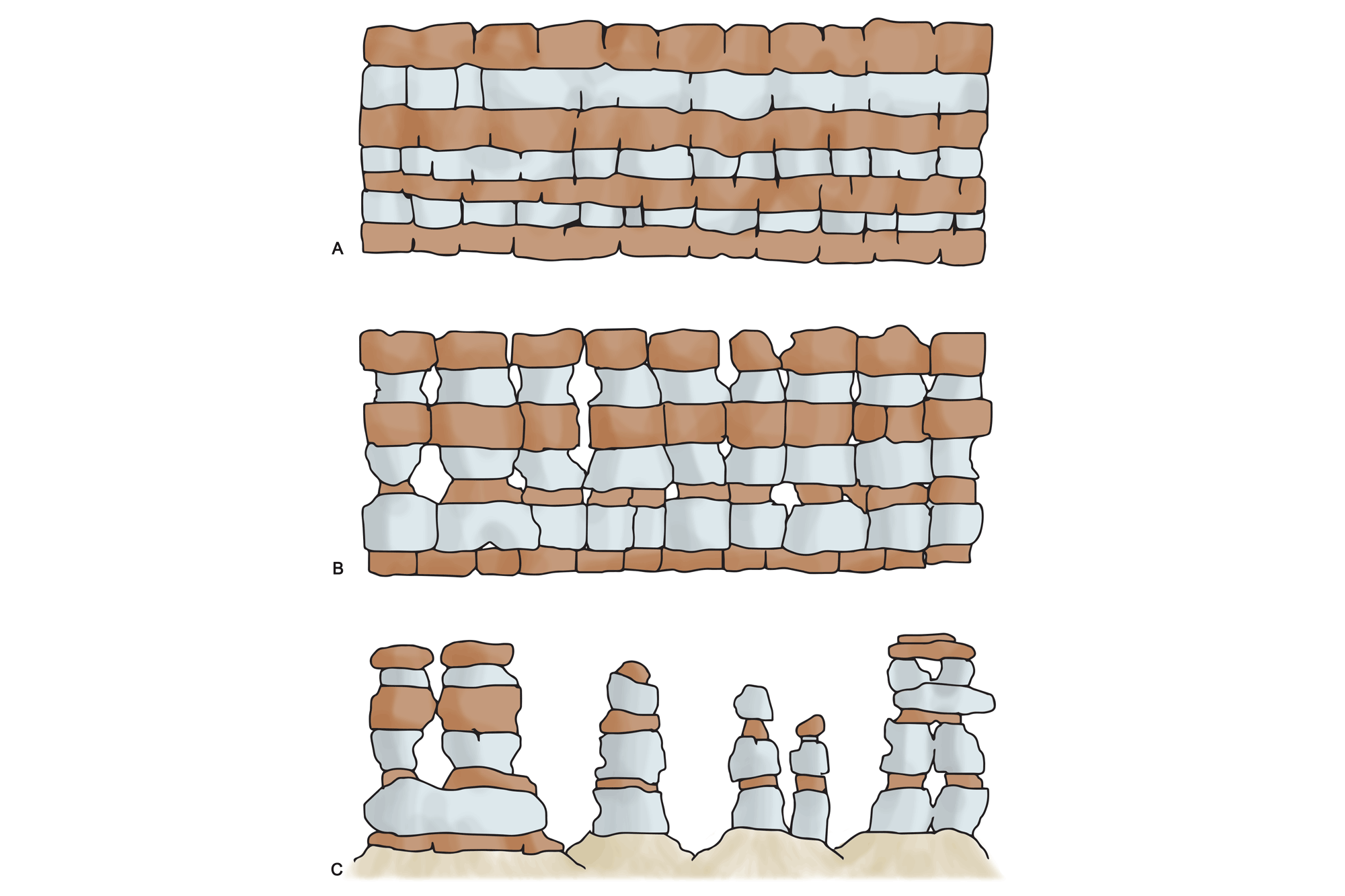
Erosive processes in the Colorado Plateau. A) Solid sedimentary strata contain fractures, joints, and other points of weakness. B) Weathering from rain and frost eats away at the sedimentary rock along its weak points. C) Progressively smaller remnants are left behind as erosion continues over time. More resistant rock layers cap the spires. Image by Wade Greenberg-Brand.

Delicate Arch, Arches National Park, Utah. The La Sal Mountains are visible in the background. Photograph by "Praveen" (Flickr; Creative Commons Attribution-NonCommercial 2.0 Generic license).
The differing patterns of vertical joints in the rocks are a major factor in the production of this variety of bizarre features. In thick massive sandstones such as the Navajo Formation exposed in Zion National Park, erosion of vertical joints has produced deep and narrow canyons with up to 600 meters (2000 feet) of relief on nearly vertical canyon walls. The same type of erosion has created thousands of spectacular hoodoos in Bryce Canyon.
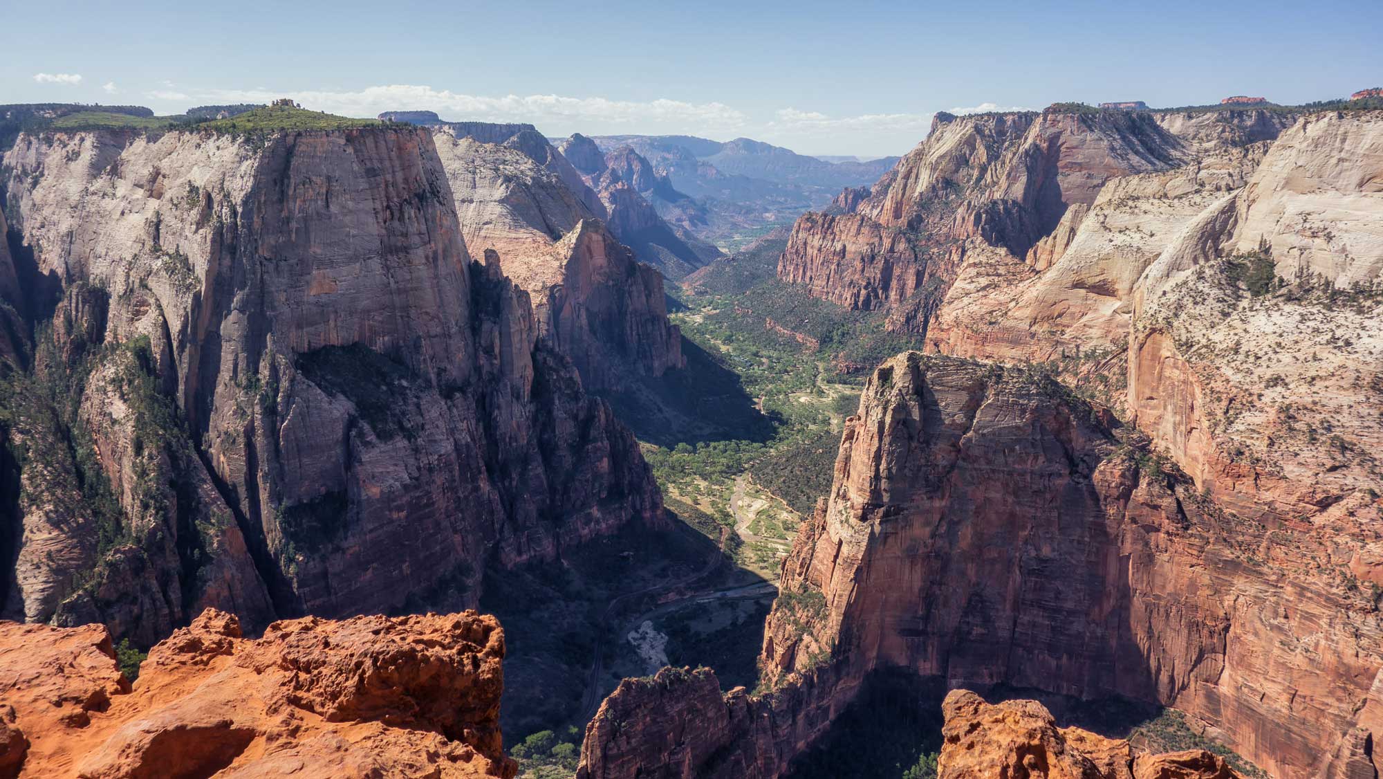
Steep canyon walls in Zion Canyon, Zion National Park, Utah. Photograph by "PinkFloydFanSince1986" (Flickr; public domain).
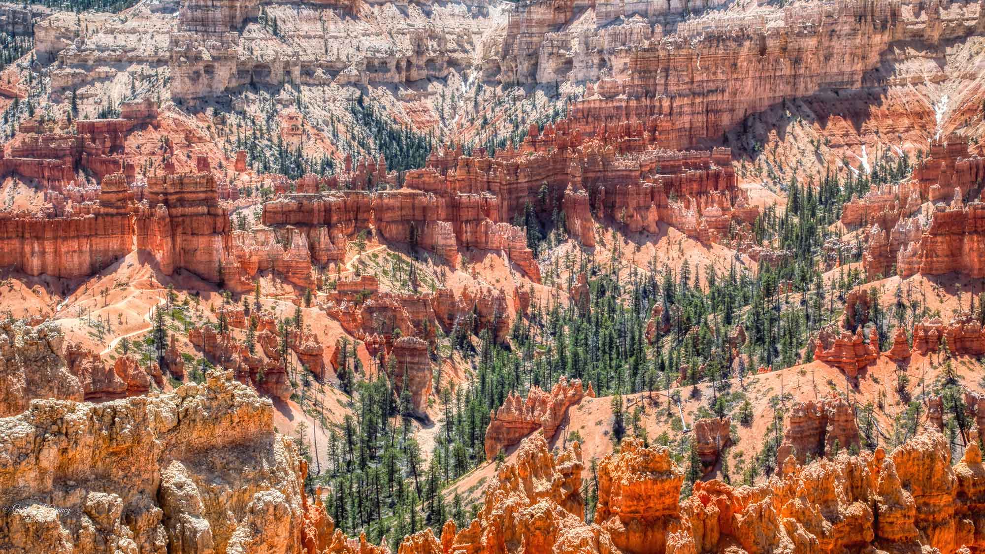
Hoodoos at Bryce Canyon National Park, Utah. Photograph by G. Lamar (Flickr; Creative Commons Attribution 2.0 Generic license).
In spite of the plateau's generally semi-arid climate, erosion of such features is aided by localized, intense thunderstorms that produce very energetic (and dangerous) flash floods, transporting considerable masses of rock debris. The gorges, slots, and chasms of the Canyon Lands are a particularly prominent example of the erosive actions of flash floods. The area boasts the highest concentration of slot canyons in the world—these features are formed by the wear of water rushing through rock, and are extremely tall and narrow. Antelope Canyon, a slot canyon located approximately 10 kilometers (6 miles) southwest of the town of Page, Arizona, near the Glen Canyon Dam, is over 30 meters (100 feet) deep but measures only a few meters (yards) in width.
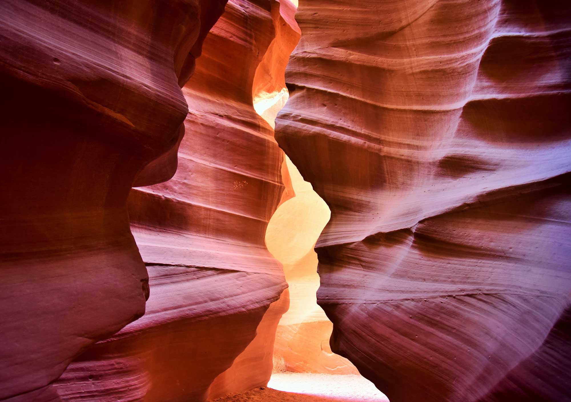
Antelope Canyon, Arizona, a slot canyon characterized by the flowing spiral shape of its walls. The canyon was formed by erosion of the Navajo Sandstone due to flash flooding. Photograph by Akashi Muramatsu (Flickr; Creative Commons Attribution 2.0 Generic license).
The Upper and Lower Antelope canyons are carved in a 300-meter-long (1000-foot-long) section of Navajo Sandstone that partially blocks Antelope Creek, a stream that flows north to join the Colorado River. During flash floods, water fills the upstream basin, forcing mud- and sand-saturated water through a crack in the obstruction. The combination of turbulent flow interacting with the sand dune structures of the Navajo Sandstone has produced intricately carved and incredibly beautiful slot canyons.
In places, the Colorado Plateau has been deformed by sharp, fault-cored folds called monoclines. These geologic landforms are step-like folds in rock strata, where an otherwise horizontal rock sequence dips steeply. The Waterpocket Fold, a monocline that defines Capitol Reef National Park, extends for nearly 160 kilometers (100 miles) across the Canyon Lands of central Utah. It formed between 70 and 50 million years ago, when the Laramide Orogeny activated a buried fault. The overlying rock layers on the fold's west side were lifted more than 2100 meters (7000 feet) higher than those on the east side.
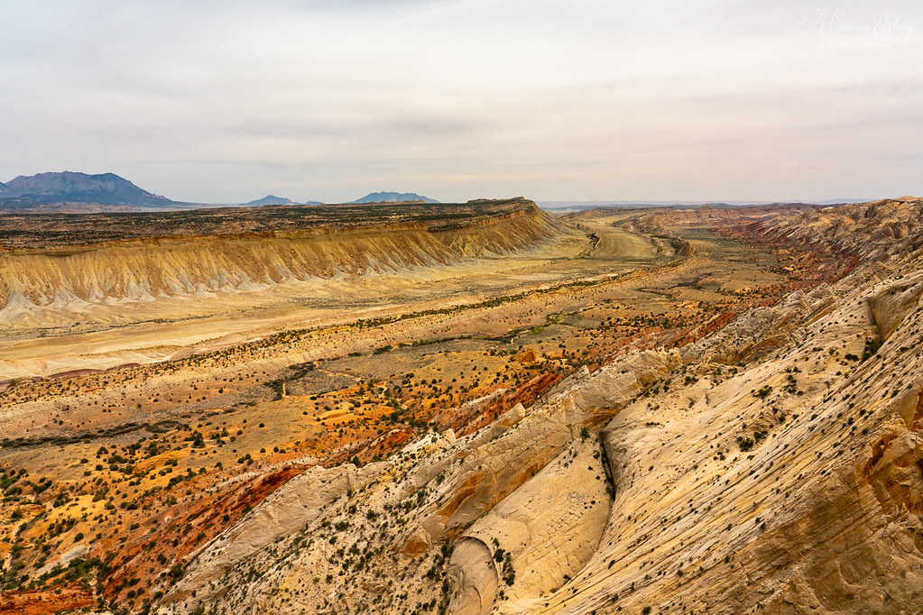
A view south along the Waterpocket Fold, Utah, which slopes steeply down across the white Navajo Sandstone. The formation is named for its "waterpockets," small depressions that form when rain erodes the sandstone. Photograph by "Sathish J" (Flickr; Creative Commons Attribution-NonCommercial-NoDervis 2.0 Generic license).
Today, the erosion of these tilted rock layers, which dip sharply downwards to the east, has resulted in colorful cliffs with fantastical domes, spires, and monoliths. Capitol Reef National Park is named for its white domes of Navajo Sandstone, which resemble the dome of the Capitol Building.
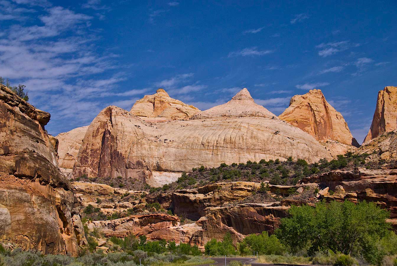
Capitol Dome and other white domes of Navajo Sandstone are common geologic features in Capitol Reef National Park, Utah. Photograph by John Fowler (Flickr; Creative Commons Attribution 2.0 Generic license).
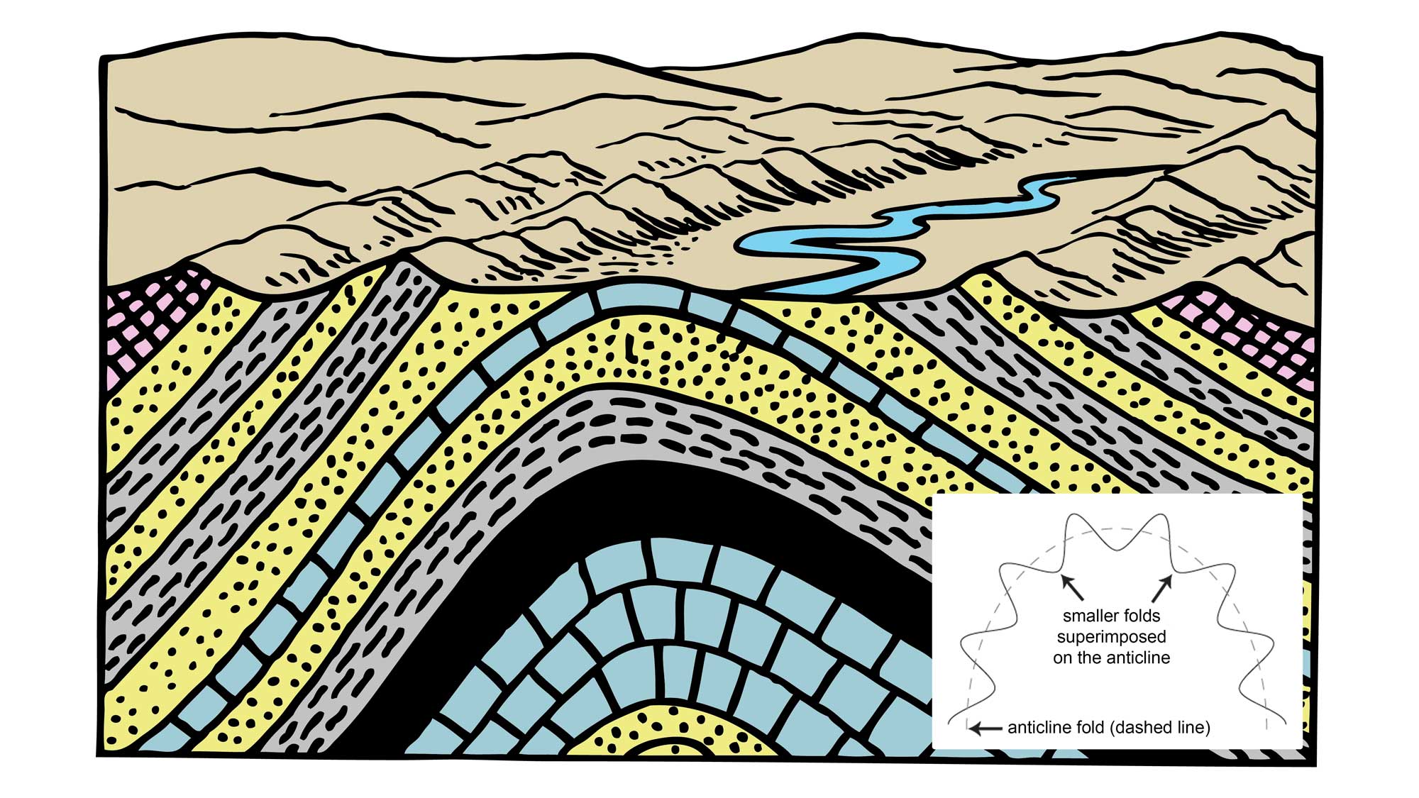
Cartoon drawing of an anticline, which is an upward fold in layered rocks. The inset image shows the structure of an anticlinorium, which is a large scale anticline composed of numerous small folds (anticlines and synclines). Cartoon drawing by Pearson Scott Foresman (Wikimedia Commons; public domain). Inset image by Jim Houghton. Both images modified for the Earth@Home project.
The San Rafael Swell of central Utah is a 120-kilometer-long (75-mile-long) sandstone anticline that was pushed up during the Paleocene. Today, its sedimentary rocks have eroded into valleys, canyons, and mesas, exposing the Jurassic Navajo and Wingate sandstones and the Permian Coconino and Kaibab formations. I-70 cuts across this area, exposing the rock strata and providing beautiful vistas.
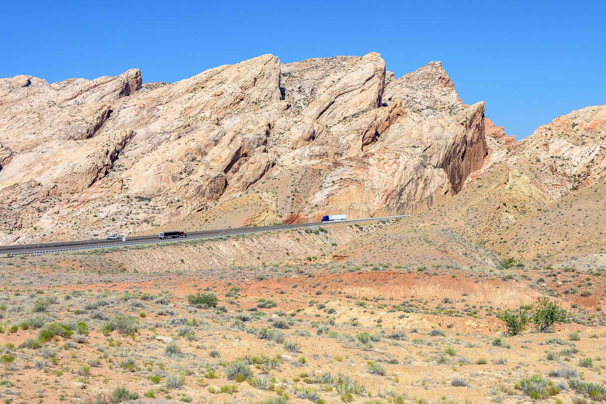
Interstate 70 cuts through the San Rafael Swell anticline in Utah. Photograph by Thomas Hart (Flickr; Creative Commons Attribution-NonCommercial 2.0 Generic license).
Cenozoic magmatic activity has also left major imprints on the Colorado Plateau’s topography. During the Laramide Orogeny, magma intruded into the region’s sedimentary strata and spread out, creating laccoliths—domed intrusions of magma injected into the sedimentary rock layers like jelly in a jelly donut. The laccoliths pushed up overlying sediment, which later eroded away to expose the igneous rock below. The Henry, La Sal, Abajo, and Carrizo mountains, as well as the Sleeping Ute and Lone Cone peaks, are all examples of laccolithic mountain ranges in the Canyon Lands.

The La Sal Mountains in Utah, a laccolith mountain range. Photograph by Charles (Chuck) Peterson (Flickr; Creative Commons Attribution-NonCommercial 2.0 Generic license; image resized).
Grand Canyon
Including: Grand Canyon National Park
The most extensive erosion anywhere on the Colorado Plateau has taken place at the region’s southwest corner, in the area of the Grand Canyon. Permian-aged strata are found at much of the surface, revealing the extensive erosion that has taken place during the Cenozoic. An entire section of Mesozoic strata, estimated to be perhaps 450 meters (1500 feet) thick, has been eroded from the Plateau's southwest corner.
It is at the Grand Canyon itself that the erosional power of water is so dramatically demonstrated.
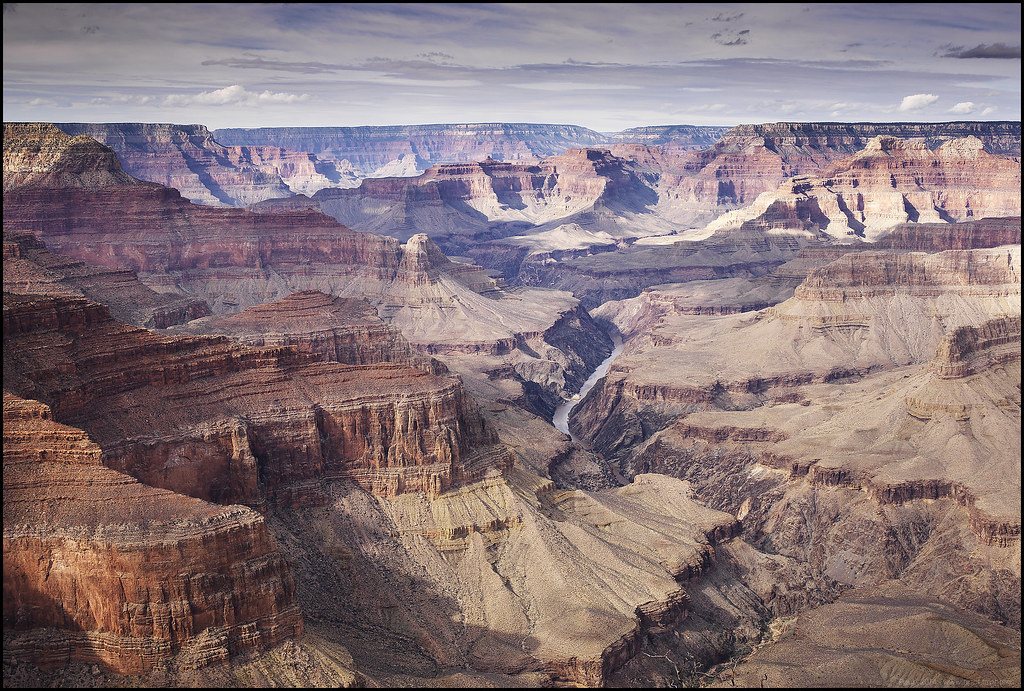
A view of the Colorado River flowing through the Grand Canyon, from Pima Point, Arizona. Photograph by "Paucal" (Flickr; Creative Commons Attribution-NonCommercial-NoDerivs 2.0 Generic license).
The Colorado River and its tributaries drain most of the Colorado Plateau, as well as the Uinta Mountains, the southwestern Wind River Mountains, the eastern Wyoming Range, and the western Rockies. The river exits the plateau into the lower elevation desert of Arizona and southern Nevada and then travels southwards, as the boundary between Arizona and California, to the Gulf of California.
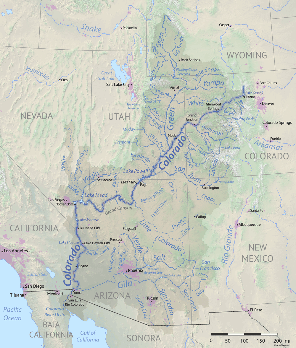
The Colorado River and its tributaries. Image by "Shanon1" (Wikimedia Commons; Creative Commons Attribution-ShareAlike 4.0 International license; image resized).
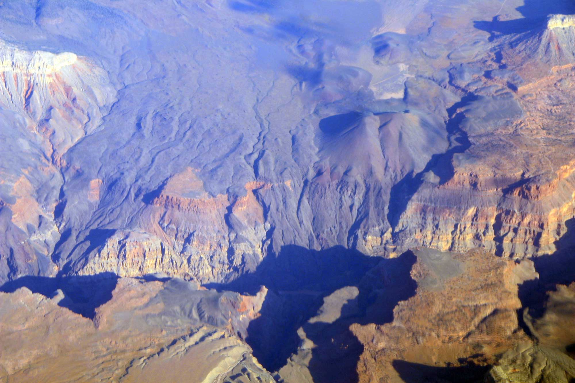
At the Grand Canyon, the Colorado River has incised through all of the area's Mesozoic and Paleozoic strata, reaching the Precambrian metamorphic and igneous basement rock.
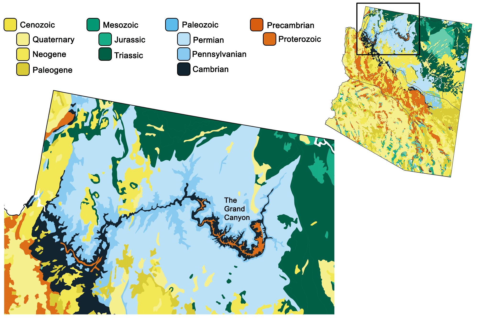
Geologic map of the Grand Canyon. Image by Jonathan R. Hendricks for the Earth@Home project using QGIS and USGS data from Fenneman and Johnson (1946) and Horton et al. (2017) using the maximum age values for each mapped unit.
The Colorado River descends steeply through the Grand Canyon from Lees Ferry, at an elevation of 940 meters (3100 feet), to about 330 meters (1100 feet), where it flows into Lake Mead. This process has formed a canyon with dramatic topographic relief—the river's elevation is over a kilometer (nearly a mile) lower than the south rim of the canyon, and two kilometers (over a mile) lower than the north rim. An enormous array of tributary canyons is also visible from the canyon’s rims. These tributaries exhibit remnant mesas and chimneys, and a step-like erosional pattern of cliffs, flats, and steep piles of rock rubble, resulting from variations in the rock layers’ resistance to erosion. In contrast, in areas where the river has incised into the very hard Precambrian basement rock, the cross-section becomes V-shaped. V-shaped streambeds form in areas where rivers cut downwards into rock that is relatively uniform in resistance.
The rise of the Colorado Plateau is closely connected to the formation of the Grand Canyon. How and when this gigantic example of fluvial erosion occurred has remained hotly debated since geologist John Wesley Powell’s trip by boat through the canyon in 1867. Many generations of geologists have questioned whether the canyon is very old, dating back to or before the Laramide Orogeny, or is geologically relatively young. Much of the literature available in past years and in tourist guides speaks of "hundreds of millions of years" as the time it took to carve the canyon, but this is incorrect. In fact, major portions of the Grand Canyon were downcut in response to the region’s uplift, starting eight million years ago, in possible combination with a lower base elevation associated with Basin and Range crustal stretching.
The Colorado River does, however, have a complex ancestry that extends further back in time. Rivers have been running through the Grand Canyon area for the tens of millions of years it has been above sea level, and some initially carved their own canyons through normal erosional processes. One such canyon on the western side, Hurricane Canyon, may have been formed by a river that flowed northwest 70 to 50 million years ago; another on the eastern side may have formed approximately 25 to 15 million years ago. Segments of the Grand Canyon probably did develop to perhaps half their current depth during an early- and mid-Cenozoic time frame. The westernmost portion upstream from Lake Mead, and the northernmost segment, Marble Canyon, formed in just the past six million years. As these young river segments integrated with older ones, they formed the modern Colorado River that widened and deepened the Grand Canyon we know today.
The entire series of Mesozoic and Cenozoic strata is preserved farther north and east of the Grand Canyon, and is progressively revealed along the Grand Staircase. Here, successively younger strata each form higher steps. Southward facing risers—the more sloping or vertical parts between the steps, also known as scarps—are formed by south-facing cliffs (cuestas) of the northward dipping strata. The cliffs have names describing their colors, including Chocolate, Vermillion, White, Gray, and Pink cliffs.
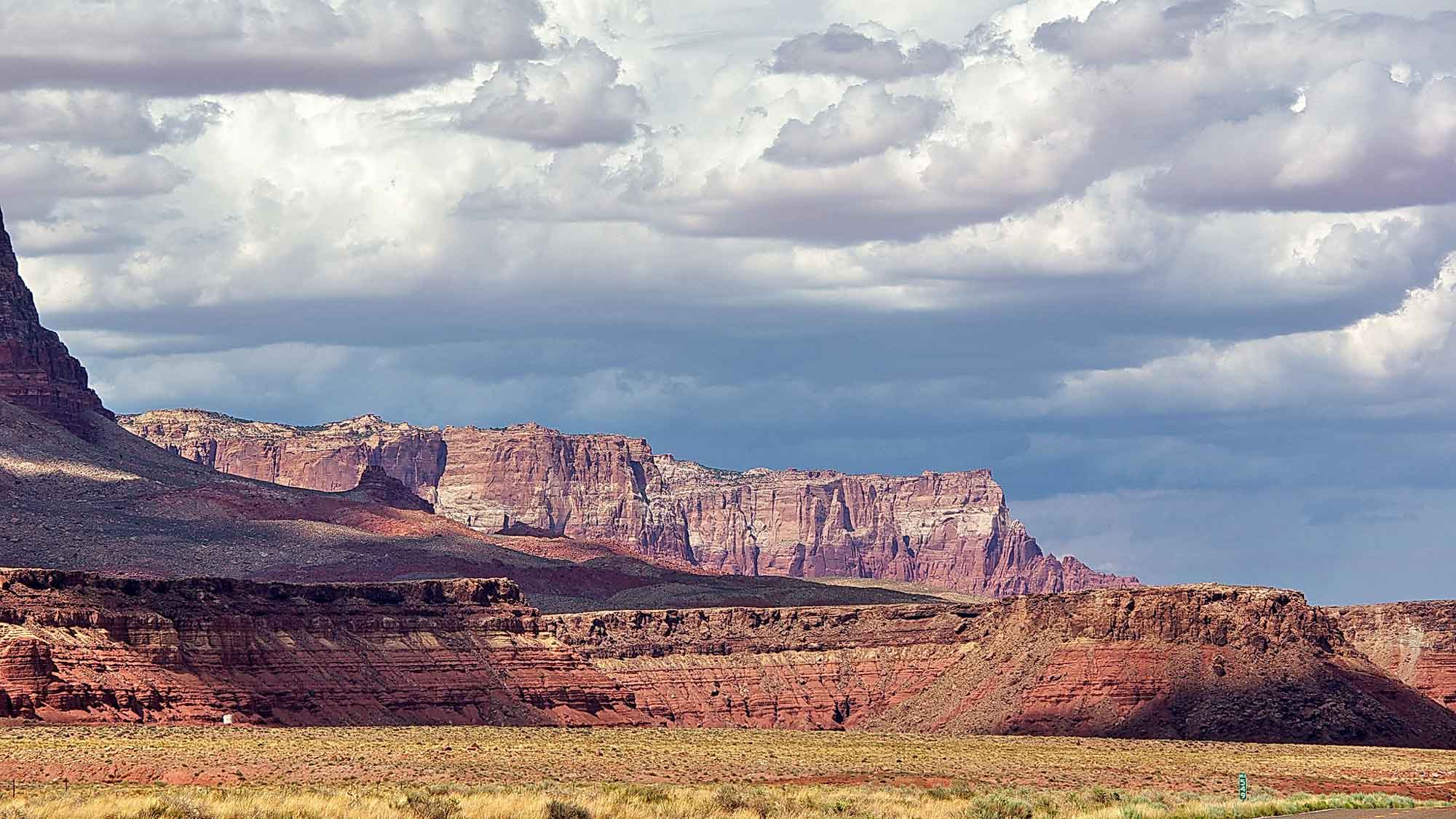
The Vermillion Cliffs near House Rock, Arizona. Photograph by "Al_HikesAZ" (Flickr; Creative Commons Attribution-NonCommercial 2.0 Generic license; image cropped and resized).
The Uinkaret Volcanic Field, which includes numerous Quaternary basaltic cinder cones and flows, is located near and on the northern rim of the western Grand Canyon. The age of these flows has provided key data for estimating the Grand Canyon’s incision rates during the past 100 to 600 thousand years. The most recent eruption in Uinkaret occurred approximately 1000 years ago; some of the lava flows spilled into the gorge and temporarily dammed the Colorado River.
In this aerial view, the black basalt of the Uinkaret Volcanic Field is seen preserved where it cascaded over the side of the Grand Canyon at Lava Falls. Photograph by Doc Searls (Flickr; Creative Commons Attribution-ShareAlike 2.0 Generic license).
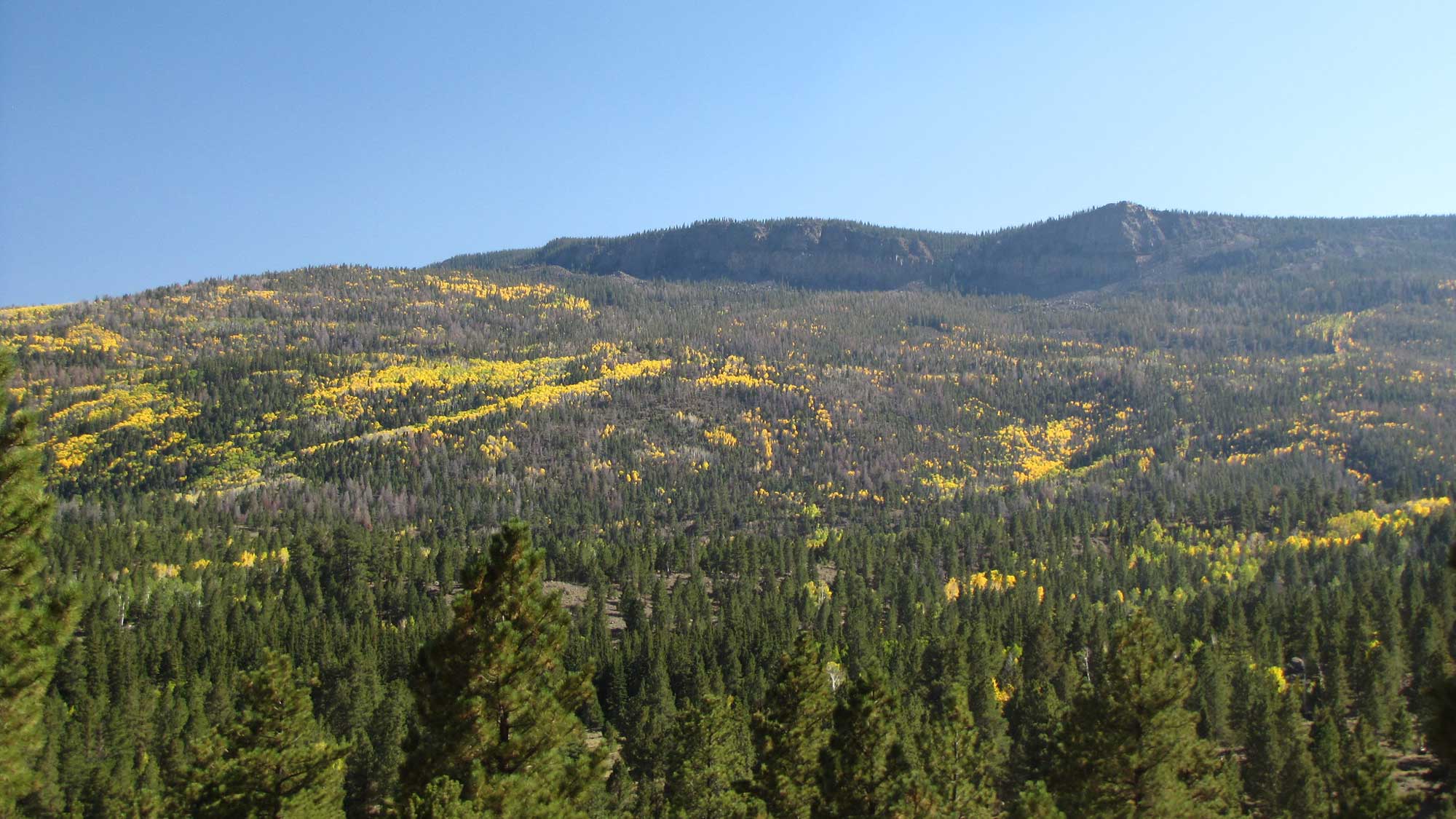
High Plateaus of Utah
North of the Grand Canyon lie the High Plateaus of Utah, a part of the Colorado Plateau where extensive volcanism has covered much of the landscape. The plateaus, separated by north-south trending normal faults, form a transition zone between the Colorado Plateau and the more fully developed extensional structures of the Basin and Range. The Marysvale Volcanic Field, which arose in the mid- and late Cenozoic, forms the caprocks of the High Plateaus in this area.
On the easternmost Aquarius Plateau, the highest forested plateau in North America, Boulder Mountain forms a high elevation mesa with a volcanic cap protecting the more erodible Mesozoic sediments beneath. The Boulder Mountain mesa, at an elevation of approximately 3350 meters (11,000 feet), had a small ice cap and glaciers during the last ice age. A combination of Quaternary glaciation and the susceptibility of the underlying sedimentary rocks to erosion has produced remarkable landslides around much of the mesa.
Boulder Mountain on the Aquarius Plateau, Utah. Photograph by Bryant Olsen (Flickr; Creative Commons Attribution-NonCommercial 2.0 Generic license).
Uinta and Piceance Basins
The Uinta and Piceance basins, both located in the Unita Basin physiographic region, encompass a diverse landscape of forests, canyons, and high mountains, which overlie deep basins formed in association with the Laramide basement uplift of the Rocky Mountains. The Uinta and Piceance basins are two parts of an ancient east-west trending basin that developed across the Utah-Colorado state boundary during the late Cretaceous. They are known for their accumulation of oil shale from the deep parts of the basin, and coal beds from the basin edges. Nearly the entire sequence of Mesozoic and Cenozoic strata, through the late Cenozoic, is preserved in this area.
Navajo and Datil Sections
Including: Meteor Crater
The Navajo and Datil sections, along the southern edge of the Colorado Plateau in Arizona and New Mexico, are dominated by Cenozoic volcanism. The San Francisco, Hopi Buttes, Springerville-Red Hill, Zuni-Bandera, and Mount Taylor volcanic fields are all located in this part of the region. Volcanism in this area of the Colorado Plateau is related to tectonic activity that stretched the neighboring Basin and Range region.
The San Francisco Volcanic Field, a young volcanic field dating from six million years ago to the Holocene, is located between the Grand Canyon and Flagstaff, Arizona. The field is dotted with 600 large and small volcanic cinder cones; most are basaltic cinder cones, but the largest edifice is an eroded stratovolcano that forms the San Francisco Peaks.
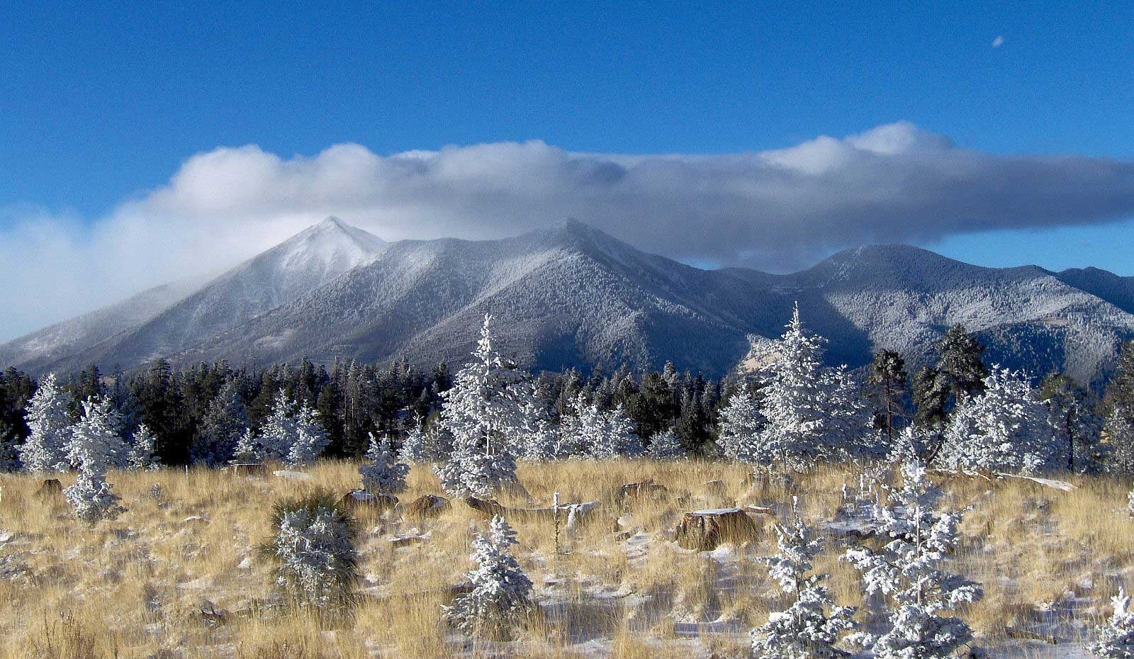
The San Francisco Peaks of north-central Arizona are a remnant of San Francisco Mountain, a former stratovolcano that collapsed around 200,000 years ago. Photograph by Coconino National Forest (Flickr; Creative Commons Attribution-ShareAlike 2.0 Generic license).
An aquifer that supplies much of Flagstaff's water is located within the volcano’s ancient caldera. The San Francisco Peaks contain the six highest peaks in Arizona, including Humphreys Peak (the highest point in Arizona at 3851 meters [12,633 feet]), and the mountain range is a popular site for hiking and skiing. The most recent eruption within the San Francisco Volcanic Field occurred between the years 1064 and 1180, forming Sunset Crater—the focus of the Sunset Crater Volcano National Monument—and nearby smaller cones and flows.
There are striking remains of volcanic maars, craters left by volcanic explosions, in the Hopi Buttes Volcanic Field. The maars are approximately 80 kilometers (50 miles) east of the San Francisco Volcanic Field, in the Navajo Reservation near the town of Dilkon, Arizona. The volcanism there is older than the San Francisco field and has been dated to seven million years ago. Erosion at Hopi Buttes exposes approximately 300 deep vertical volcanic pipes called diatremes and their associated maars. These exposures of diatremes and maars have become a mecca for geologists studying monogenetic volcanism—locations where many small volcanoes erupt only a single time each.
Chimney Butte at Hopi Buttes, Arizona. Photograph by Nate Loper (Flickr; Creative Commons Attribution 2.0 Generic license; image cropped and resized).
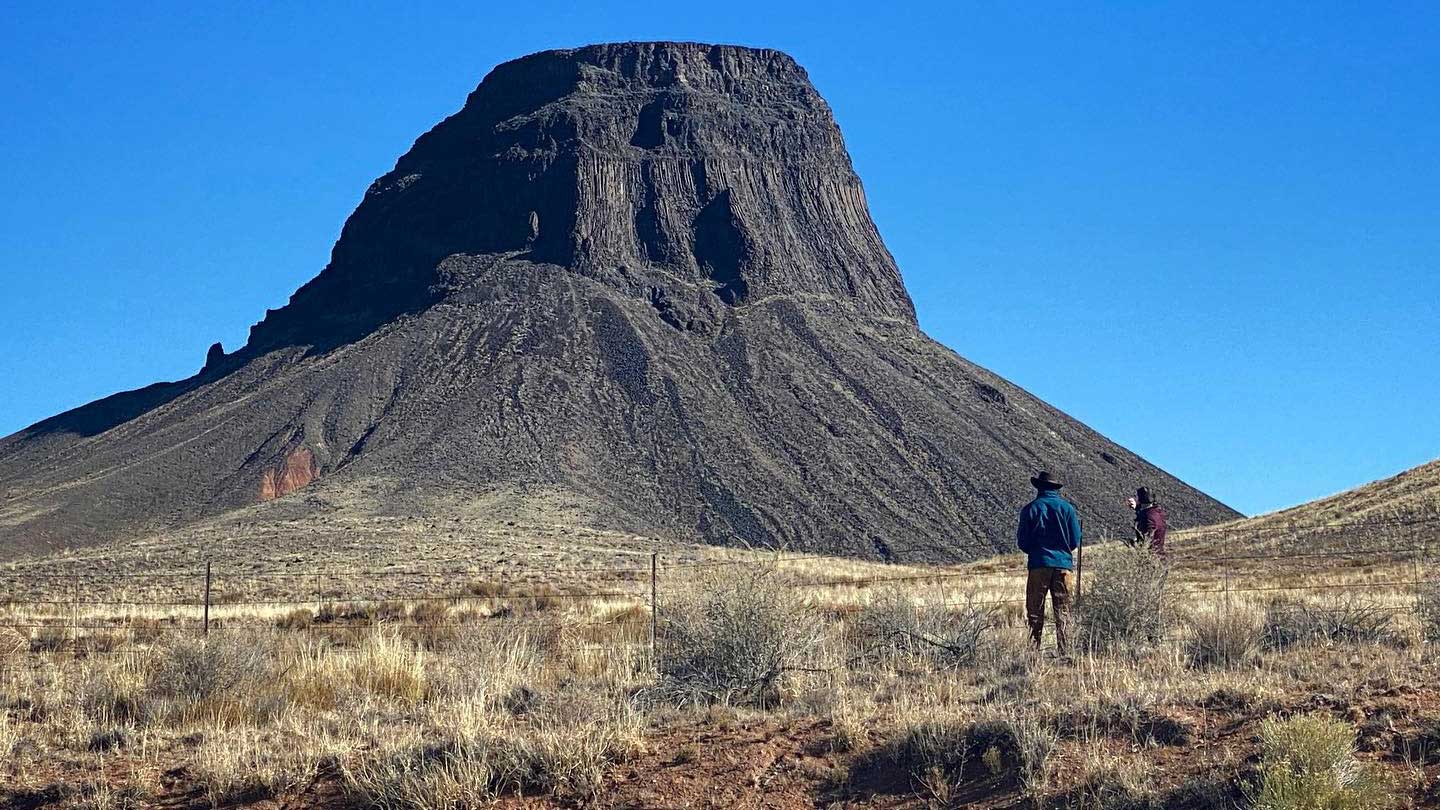
Scattered cones and basaltic flows of late Cenozoic age leave their topographic imprint in a zone trending northeast along the southern border of the Colorado Plateau including the Springerville–Red Hill, Zuni-Bandera, and Mount Taylor volcanic fields. These areas, similar to the San Francisco Volcanic Field, are characterized by basaltic flows and cinder cones plus a large eroded stratovolcano, Mount Taylor. Cabezon Peak, a prominent feature in the northwestern New Mexico landscape, is a volcanic plug—the solidified remains of magma trapped in the neck of a volcano—that is also part of the Mount Taylor Volcanic Field.
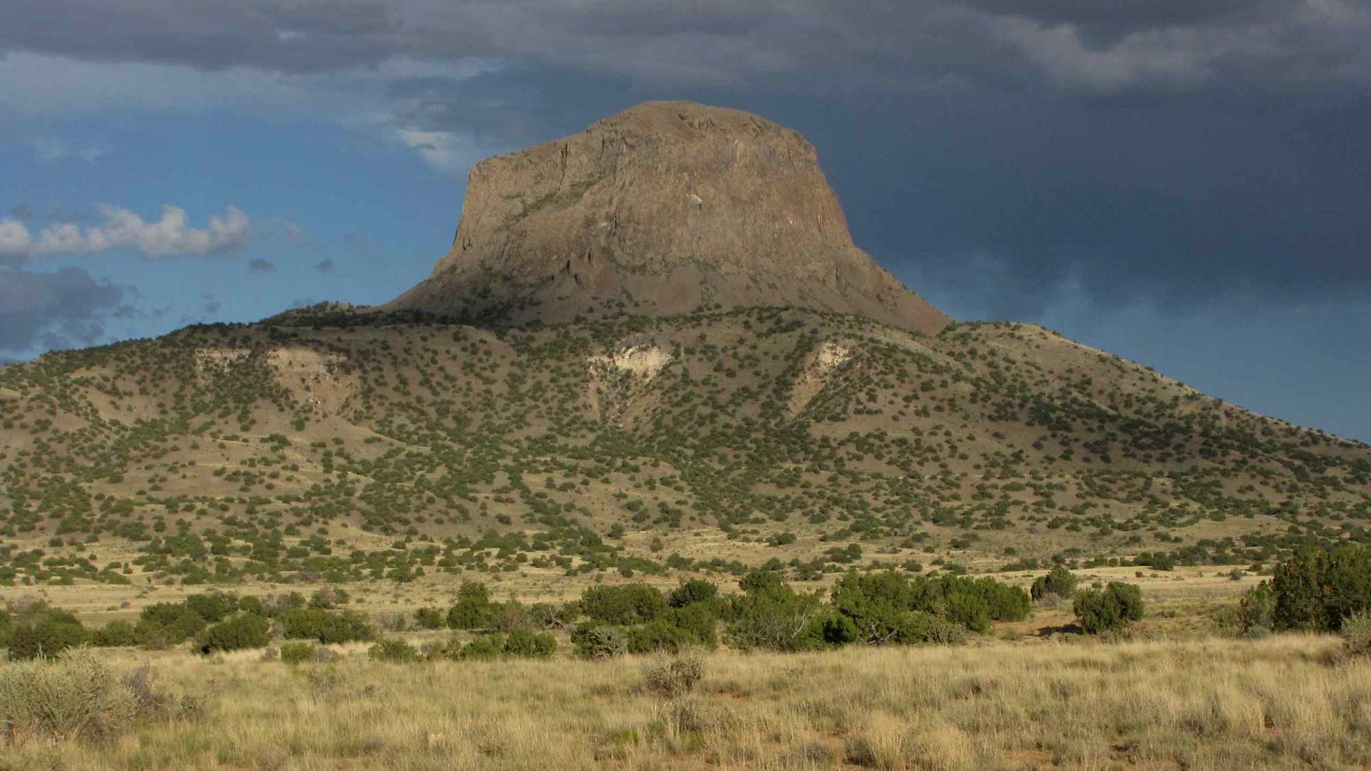
Cabezon Peak, a basalt volcanic plug that rises to 2373 meters (7785 feet) in elevation. It is part of the Mount Taylor Volcanic Field in New Mexico. Photograph by "Lon&Queta" (Flickr; Creative Commons Attribution-NonCommercial-ShareAlike 2.0 Generic license; image cropped and resized).
The Springerville–Red Hill Volcanic Field is another large area of numerous Pliocene-Pleistocene cinder cones and flows. It is located close to the southern border of the Colorado Plateau, approximately 160 kilometers (100 miles) south-southeast of the Hopi Buttes. Just to the south of this field is Mount Baldy, a deeply eroded shield volcano of late Cenozoic age. Approximately 55 kilometers (35 miles) east of Flagstaff is a small topographic feature that at first glance might be mistaken for a volcanic feature, such as a maar. This crater, approximately 1200 meters (3900 feet) in diameter and 45 meters (148 feet) deep, is in fact the result of a meteorite impact. It is, appropriately, called Meteor Crater.
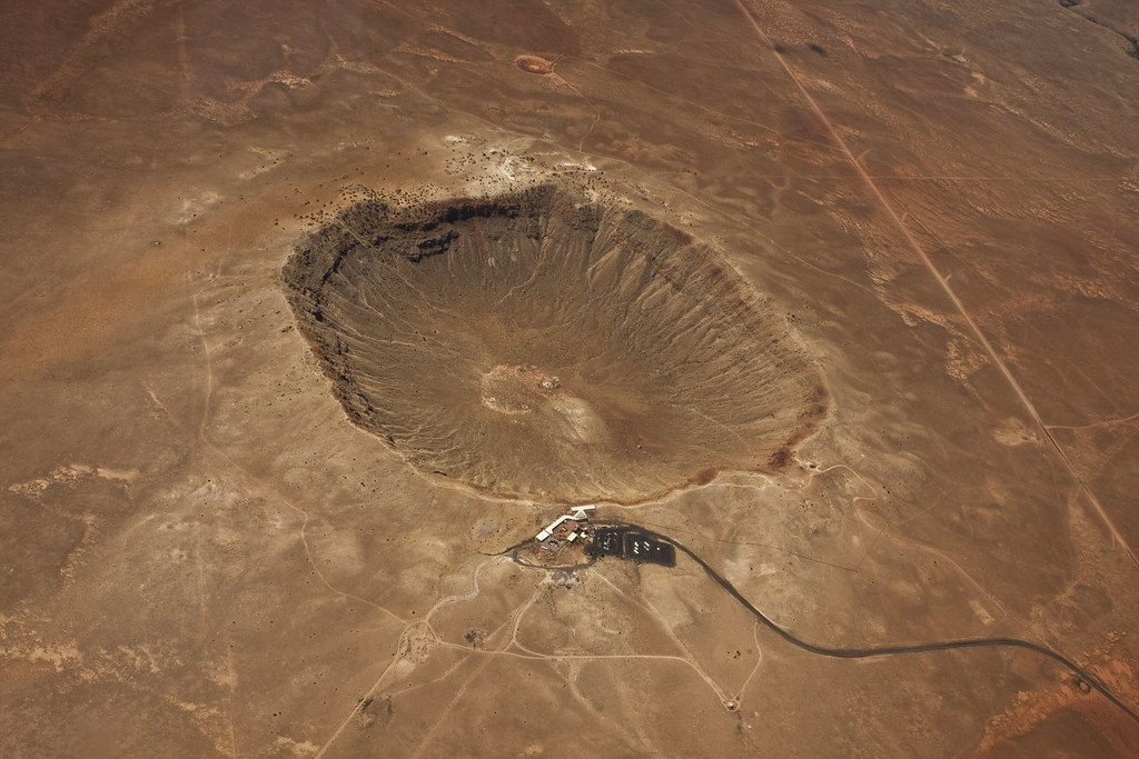
Meteor Crater (also called Barringer Crater), Coconino County, Arizona. Photograph by Mouser Williams (Flickr; Creative Commons Attribution-NonCommercial-NoDerivs 2.0 Generic license).
A nickel-iron meteorite generated the crater approximately 50,000 years ago; it is estimated to have been approximately 45 meters (150 feet) across and was mostly vaporized upon impact. The largest recovered fragment is called the Holsinger Meteorite and is exhibited at the crater's visitor center. It weighs 639 kilograms (1409 pounds) and is approximately 1.2 meters (4 feet) long.
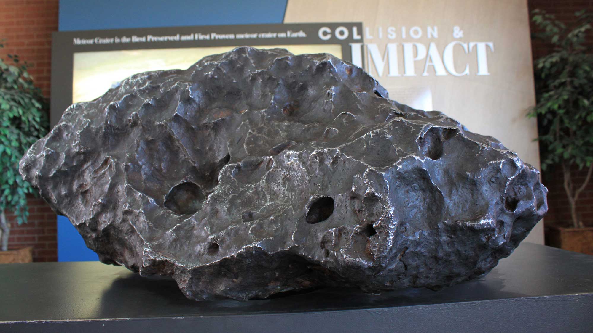
The Holsinger Meteorite, on display at the Meteor Crater visitor's center. Photograph by Natasha de Vere & Col Ford (Flickr; Creative Commons Attribution 2.0 Generic license; image cropped and resized).
The San Juan Basin, located in northwestern New Mexico and southwestern Colorado, is an area of rugged plains and valleys, covering approximately 12,000 square kilometers (4600 square miles). The basin encompasses a large, downwarped area of Mesozoic and Cenozoic rocks, formed in association with the Laramide Orogeny, and it is an important reservoir for oil and gas. Countless archaeological sites of the Ancestral Puebloan people can also be found throughout the San Juan’s sandstone canyons. The landscape is punctuated by buttes, mesas, and badlands, including Chacra Mesa, Fajada Butte, and the Bisti Badlands.
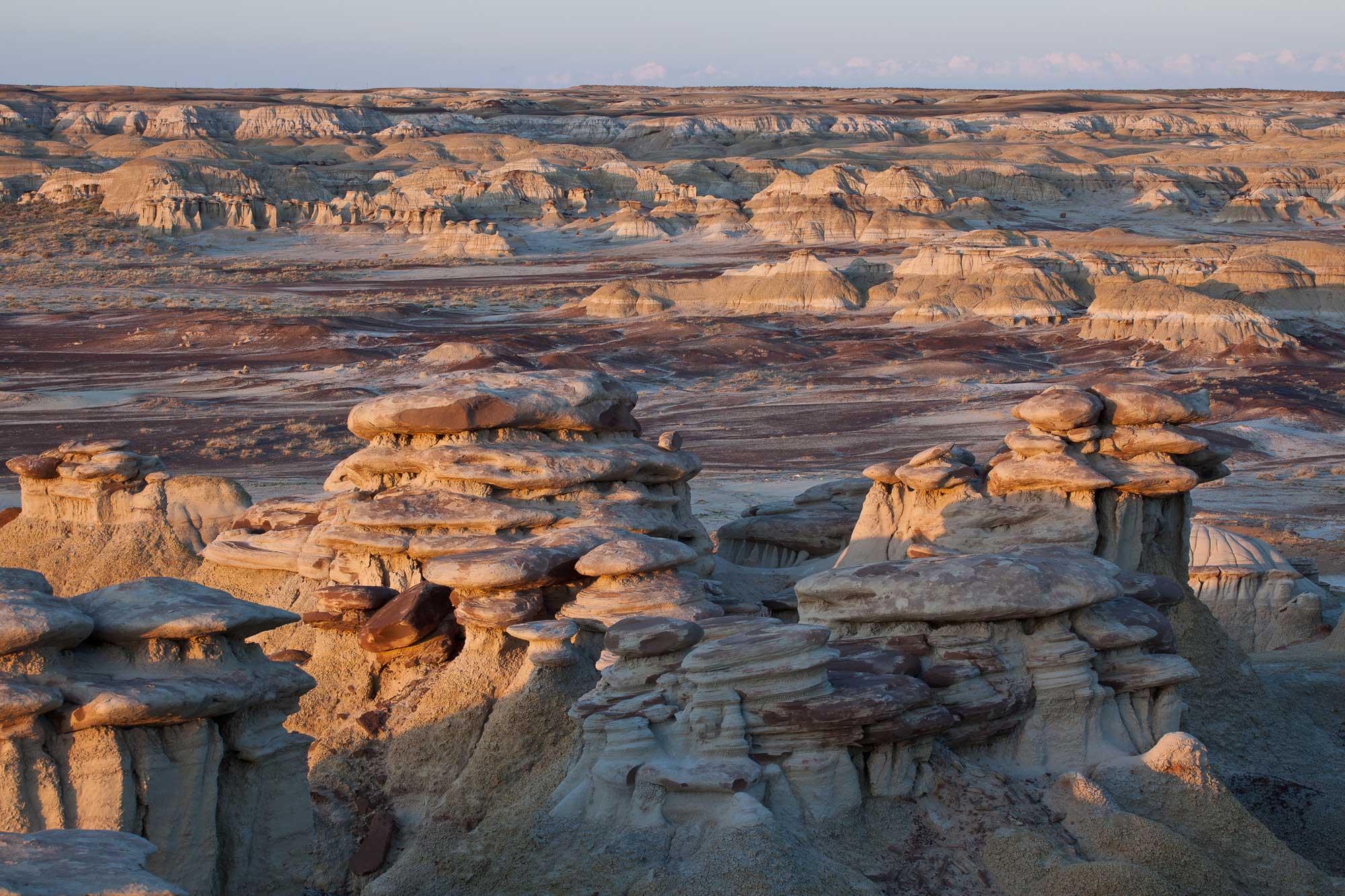
Sandstone hoodoos (foreground) and badlands (background) in the Ah-Shi-Sle-Pah Wilderness Study Area, San Juan County, New Mexico. A hoodoo forms when weathering erodes a softer material out from underneath a mass of harder capstone, leading to "mushroom" formations. Photograph by the Bureau of Land Management (Flickr; Creative Commons Attribution 2.0 Generic license; image resized).