

Page snapshot: Introduction to glaciers of the midwestern United States.
Topics covered on this page: Introduction; From the Pleistocene to the present; Rebounding of the crust; Lakes and rivers; Glacial Lake Agassiz; Glaciers and rivers; The Great Lakes; Pleistocene deposits; Glacial deposits; Loess; The Driftless Area; Glacial Lake Wisconsin; Algific talus slopes; Resources.
Credits: Most of the text of this page comes from "Glaciers in the Midwestern US" by Alex F. Wall, chapter 6 in The Teacher-Friendly Guide to the Earth Science of the Midwestern US, edited by Mark D. Lucas, Robert M. Ross, and Andrielle N. Swaby (published in 2014 by the Paleontological Research Institution). This book were adapted for the web by Elizabeth J. Hermsen and Jonathan R. Hendricks in 2022. Changes include formatting and revisions to the text and images. Credits for individual images are given in figure captions.
Updates: Page last updated September 14, 2022.
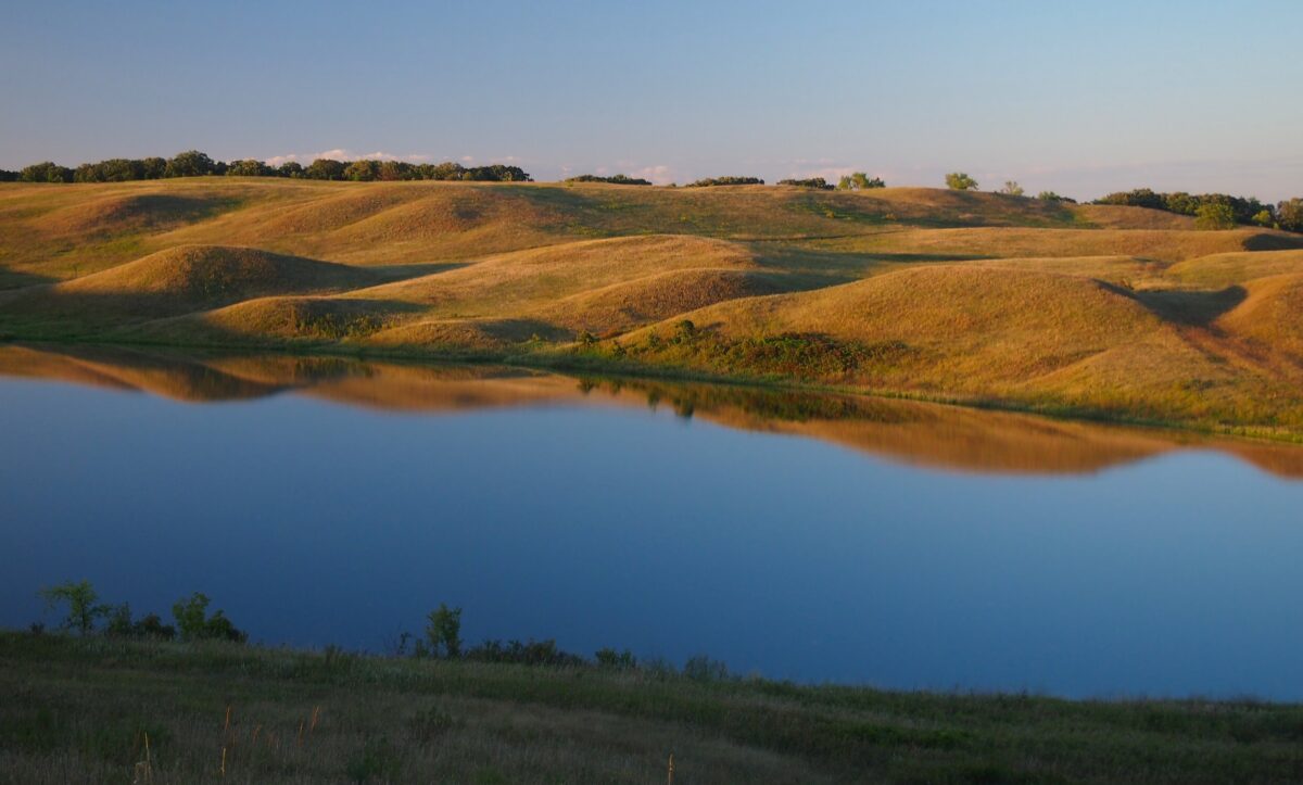
Image above: Kettle Lake, Glacial Lakes State Park, Prairie Pothole Region, Minnesota. Photo by McGhiever (Wikimedia Commons, Creative Commons Attribution-ShareAlike 4.0 International license).
Introduction
The ancient geologic history of the Midwest is often disguised by its more recent geologic history, one that was dominated by glaciers. During the Quaternary period, which began 2.6 million years ago and extends to the present, ice at times extended southward from Hudson Bay area and began to encroach on the northern United States. At different points during the Quaternary period, ice has covered all of the Midwest except for the extreme southern parts of Illinois, Indiana, Ohio, and a unique region called the Driftless Area. These ice sheets scraped away and ground up whatever rock was at the surface. When the ice finally retreated, it dropped its load of rock and dirt, forming much of the landscape we see today and obscuring the bedrock below in many feet of sediment.
More than any other force, the glaciers are responsible for the landscape of the Midwest: they smoothed peaks, filled valleys, pocked the area with ponds, and carved the Great Lakes.
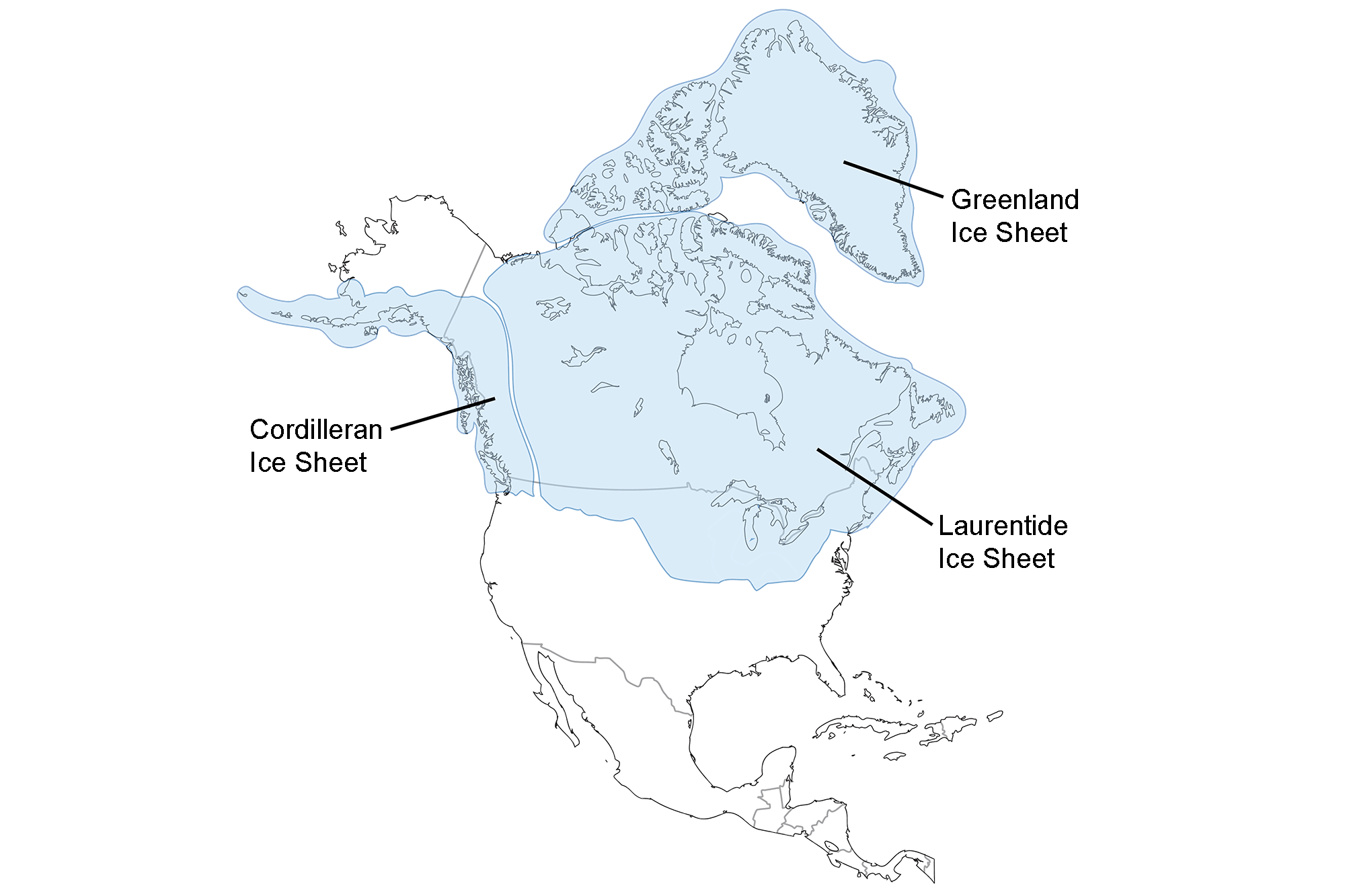
Extent of glaciation over North America at the Last Glacial Maximum. Image adapted from map by the USGS (public domain).
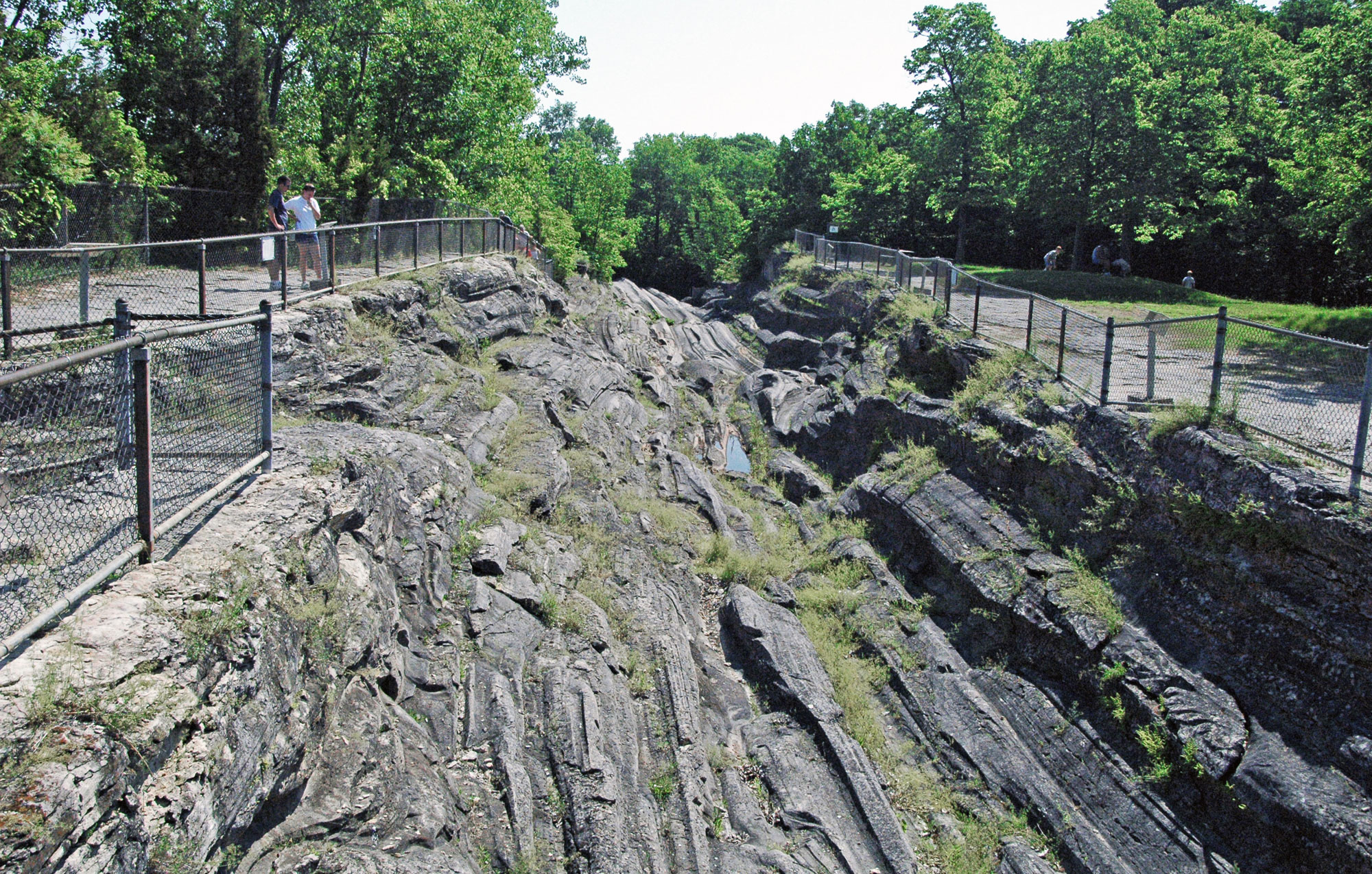
Dramatic glacial grooves in the Devonian Columbus Limestone, Kelleys Island, Lake Erie, Ohio. Photo by James St. John (flickr, Creative Commons Attribution 2.0 Generic license, image resized).
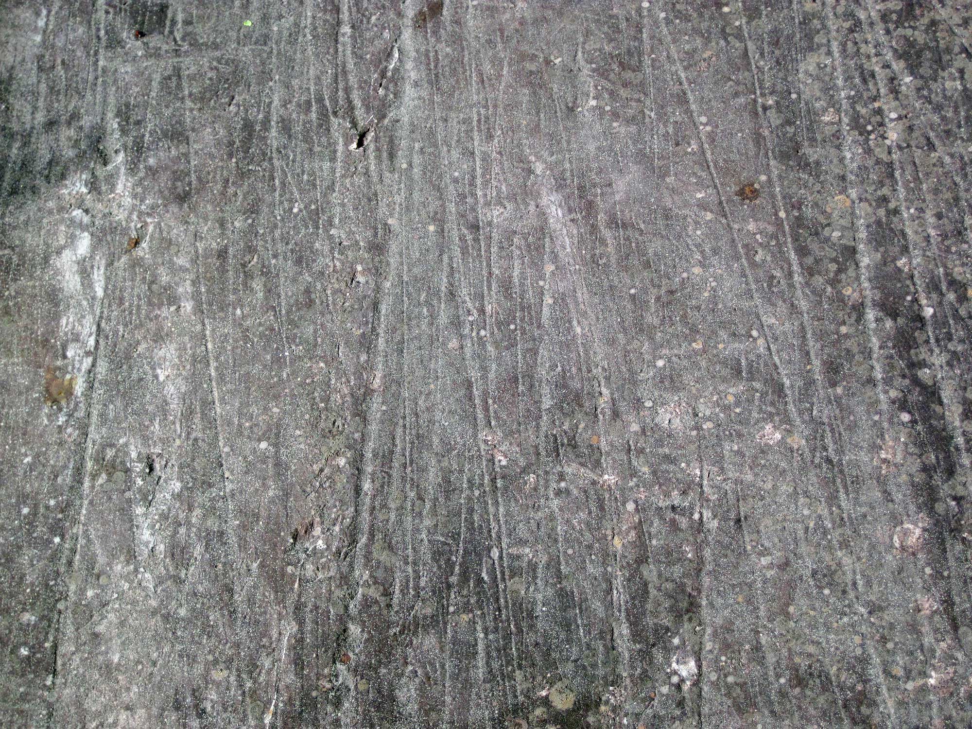
Pleistocene glacial striations on Neoarchean rock, Virginia, Minnesota. Photo by James St. John (flickr, Creative Commons Attribution 2.0 Generic license, image resized).
From the Pleistocene to the Present
Before the Pleistocene began, cooling climate triggered the start of a series of glacial advances. During the Pleistocene, there were several dozen intervals of glaciation separated by warmer interglacial intervals characterized by glacial retreat. In North America, these cycles are known as the pre-Illinoian (1.8 million–302,000 years ago, including glacial and interglacial stages), Illinoian glaciation (191,000–131,000 years ago), Sangamonian interglacial (131,000–85,000 years ago), and Wisconsinian glaciation (85,000–11,000 years ago).
The most recent glacial period began 85,000 years ago and affected the Midwest until about 10,000 years ago. Ice spread from a single dome located in northern Canada over the Hudson Bay and eventually covered much of the Midwest. Approximately 20,000 years ago, this ice sheet reached its maximum extent and covered parts of the Midwest. Even during this time of glacial advance, the glacier was always melting at its fringes, shaping the landscape at the glacial front (the periglacial zone).
By 18,000 years ago, warming of the climate caused the the ice sheet to begin to retreat. During this time of glacial retreat, the ice sheet was not actually flowing backwards; the glacier continued to flow forward, but it was melting faster than it was advancing. While the ice sheet alternately moved forward and melted backward during its retreat, its overall movement was backward. Moraine deposits mark the extent of glacial advance in the Midwest.
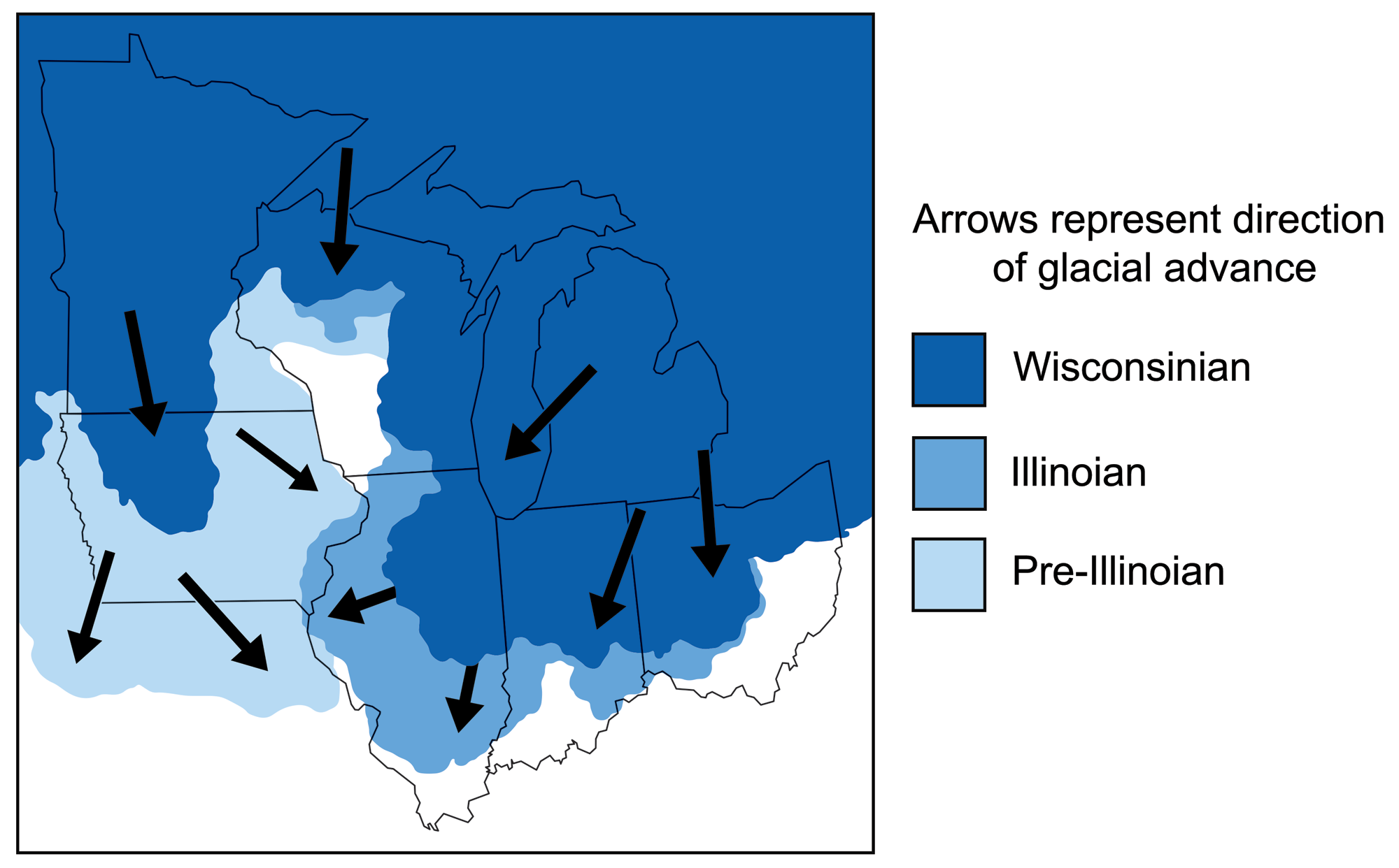
Map of the midwestern states showing Pleistocene glaciations. Each glacial advance differed slightly and left different sets of deposits. Adapted from figures by C.L. Matsch and USGS.
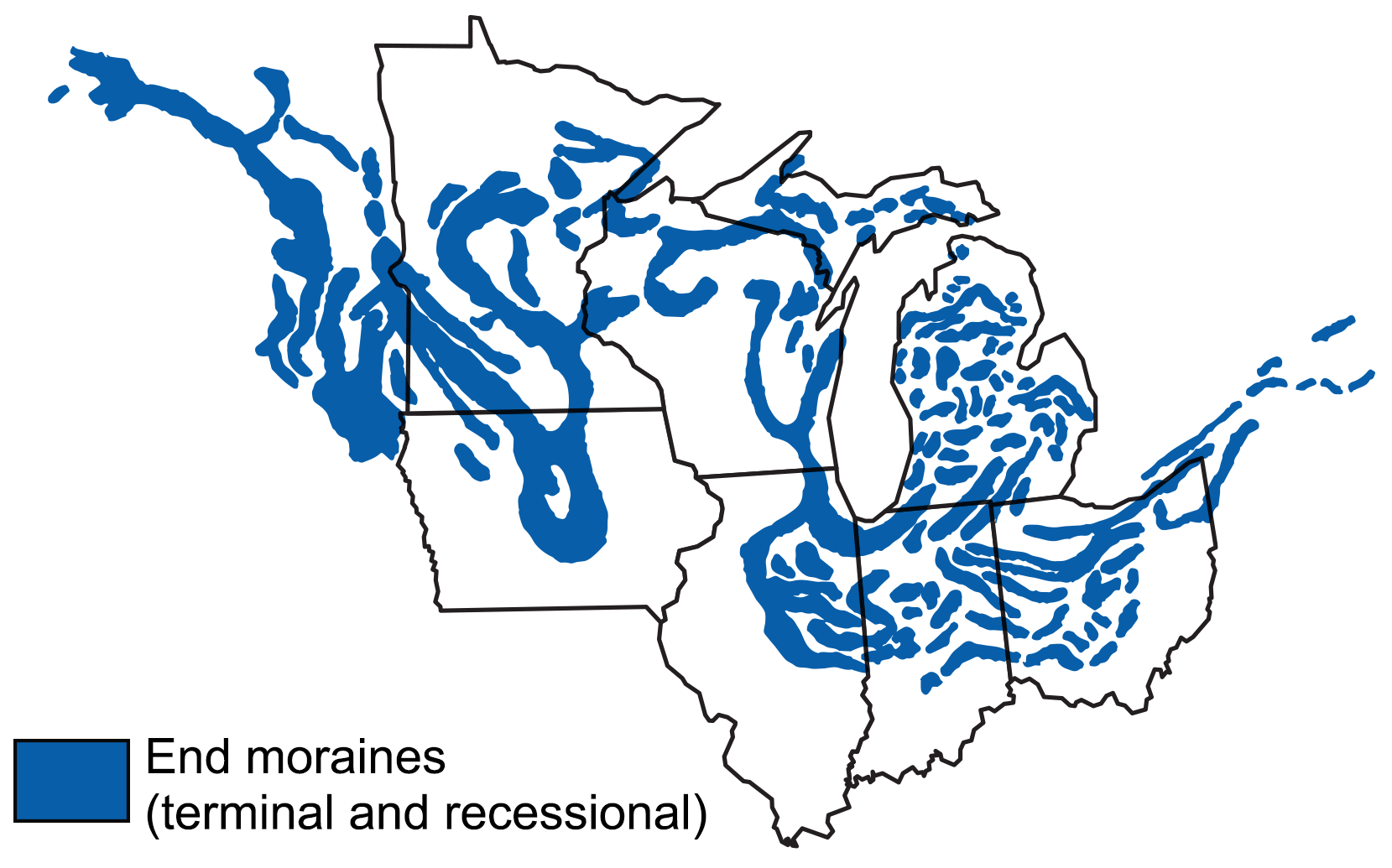
In addition to other deposits, glaciers resulted in moraine deposits throughout the Midwest. In some cases, these deposits added topographic relief to otherwise flat terraine. The moraines help define the extent of glacial advances.
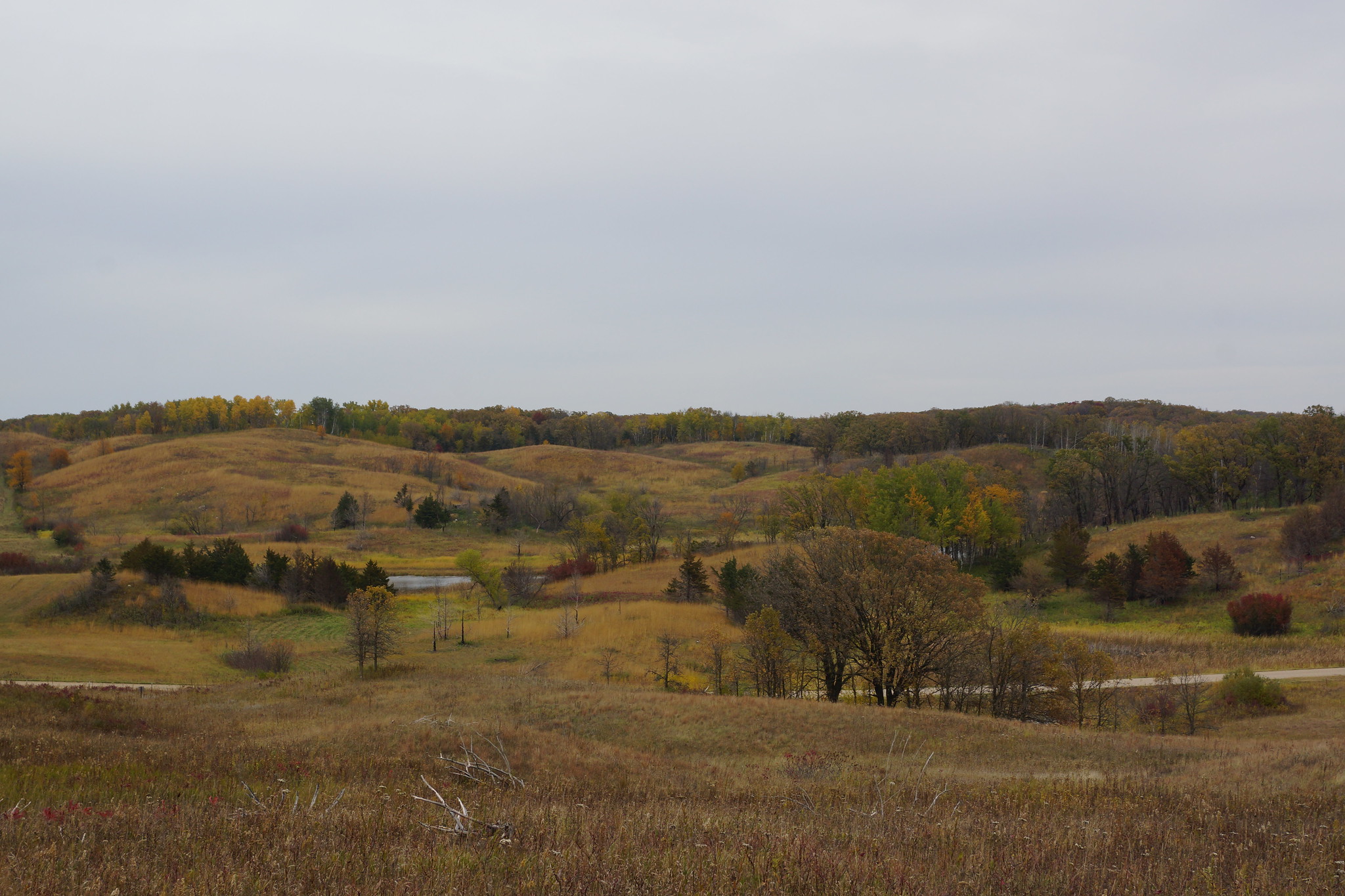
Landscape along the Glacial Ridge Trail, Minnesota, 2017. The landscape in this region is shaped by deposits of the Alexandria Glacial Moraine Complex, and includes eskers, kettles, and kames. Photo by Greg Gjerdingen (flickr, Creative Commons Attribution 2.0 Generic license).
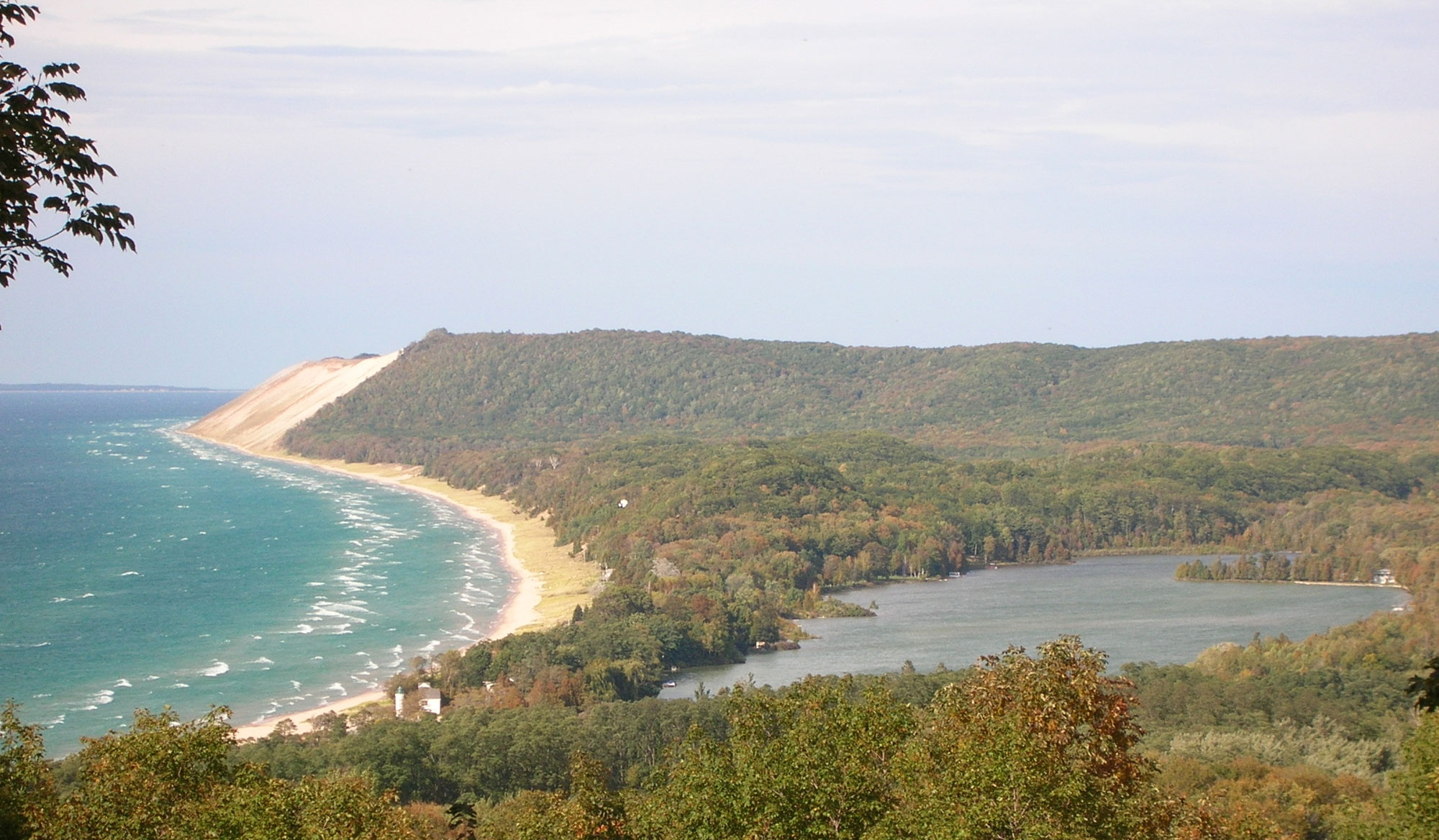
Empire Bluff, Sleeping Bear Dunes National Lakeshore, Michigan. This bluff is made up of glacial moraine that is being eroded by water and wind, forming perched dunes on top of the bluff. Photo by National park Service (public domain).
Rebounding of the Crust
The Pleistocene ice sheets could exceed two kilometers (1.2 miles) in thickness. The enormous weight of all of that ice over the continent depressed the crust into the asthenosphere (the uppermost part of the mantle), just as the weight of a person in a canoe causes the boat to ride lower in the water. When the person steps out of the canoe, the buoyancy of the canoe allows it to once again rise.
As the ice sheet retreated from the Midwest during the current interglacial period, the crust rebounded, and it continues to do so today. The equilibrium achieved between the crust and mantle is known as isostasy. This rebound is thought to be a cause of infrequent, but occasionally severe, seismic activity in the Midwest.
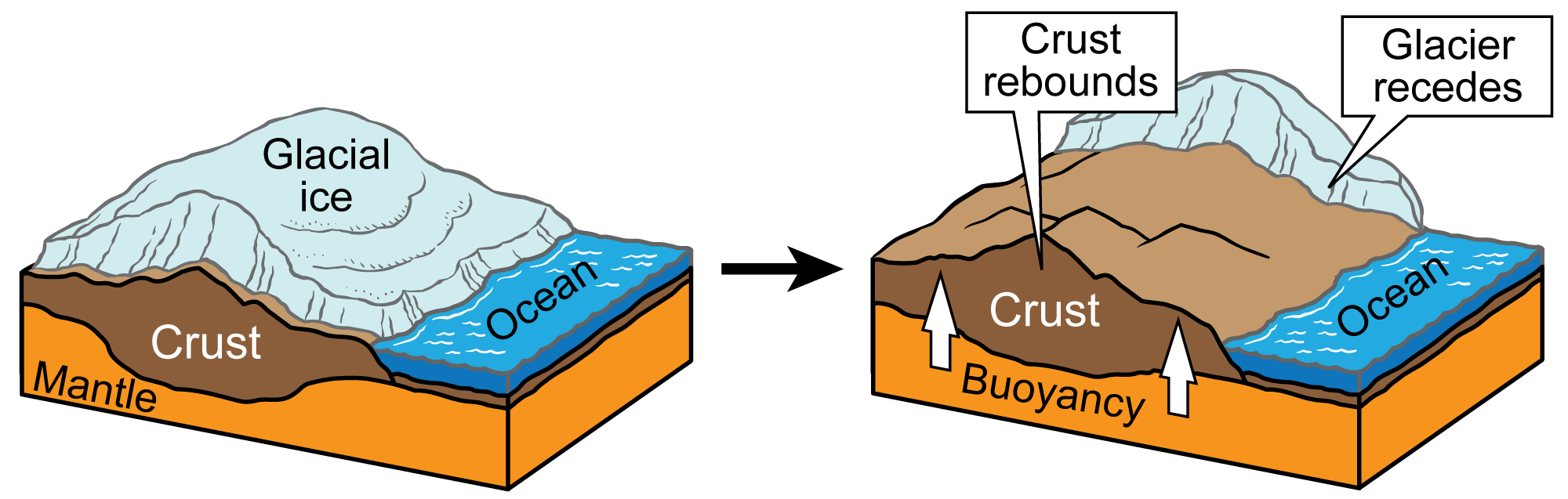
As dense glacial ice piles up, a glacier is formed. The ice begins to move under its own weight and pressure. Through isostacy, glaciers push the crust down, and, when they melt, the crust rebounds upward. Image by Jim Houghton; modified for the Earth@Home project.
Lakes and Rivers
Glacial Lake Agassiz
During the ice age, glaciers created dams that diverted rivers to the south and formed lakes such as Glacial Lake Agassiz. This enormous lake, stretching from Saskatchewan down into Minnesota and eastern North Dakota, was formed by water that accumulated in front of the Laurentide Ice Sheet. Most of the area that is now eastern North Dakota and northwestern Minnesota would have been close to the shoreline of Lake Agassiz.
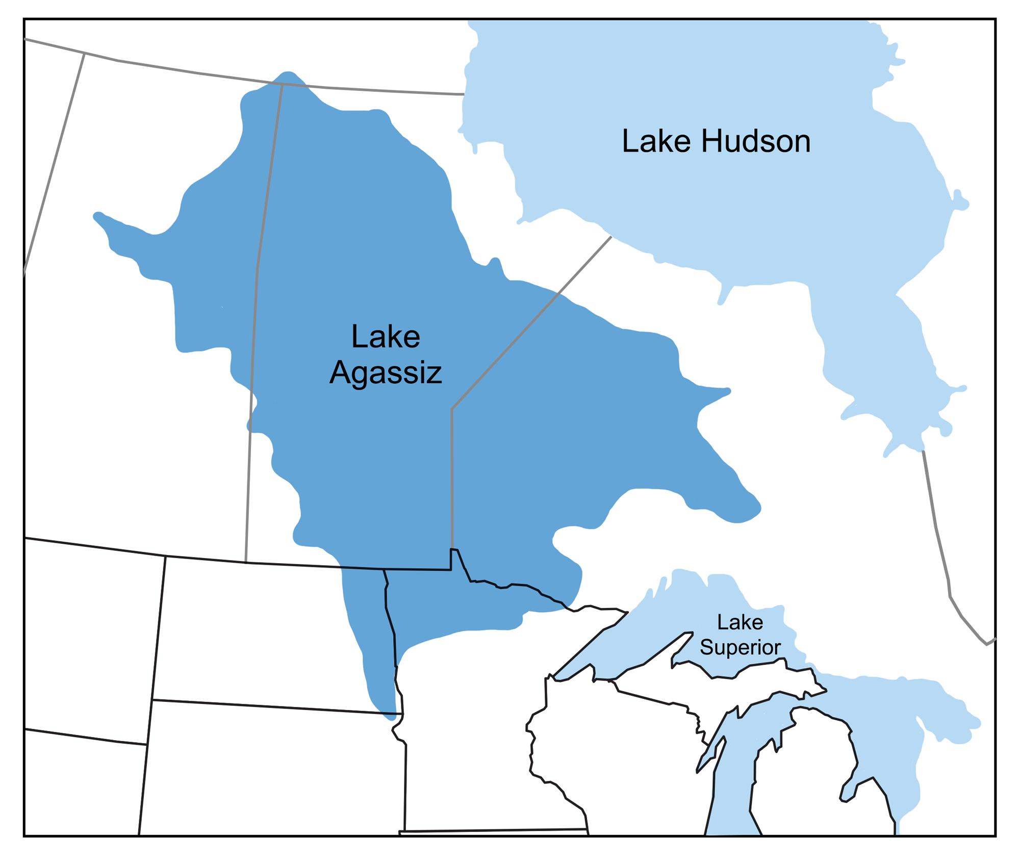
Map showing the extent of glacial Lake Agassiz. Map modified from a map by Wade Greenberg-Brand, originally published in The Teacher-Friendly Guide to the Earth Science of the Northwest Central US.
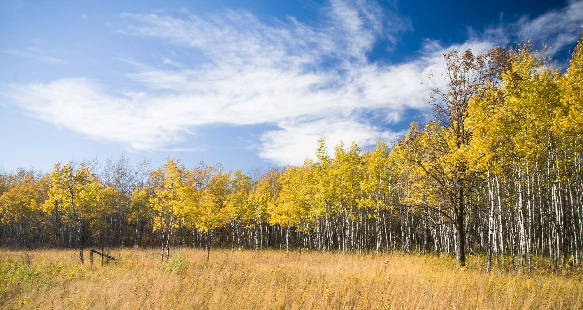
Aspen Parklands, Caribou Wildlife Management Area, Minnesota. This area in northern Minnesota was once covered by Lake Agassiz. Photo by Justin Meissen (flickr, Creative Commons Attribution-ShareAlike 2.0 Generic license, image resized).
Glaciers and rivers
The drainage of rivers and streams was also changed by the Pleistocene glaciation. Creeks and rivers in the Midwest (other than in the Driftless Area, discussed further below) have been following their current courses for only a few tens of thousands of years, at most. As glaciers scraped over the area, the ice sheets covered river valleys and filled them with sediment, effectively shoving the rivers out ahead of them by forcing water to flow around their margins. Much of the Missouri, Ohio, and Mississippi Rivers outline the farthest extent of ice sheet advances. This underscores the importance of glaciers to the Midwest: the borders of several states, defined by these rivers, are the direct result of glacial action!
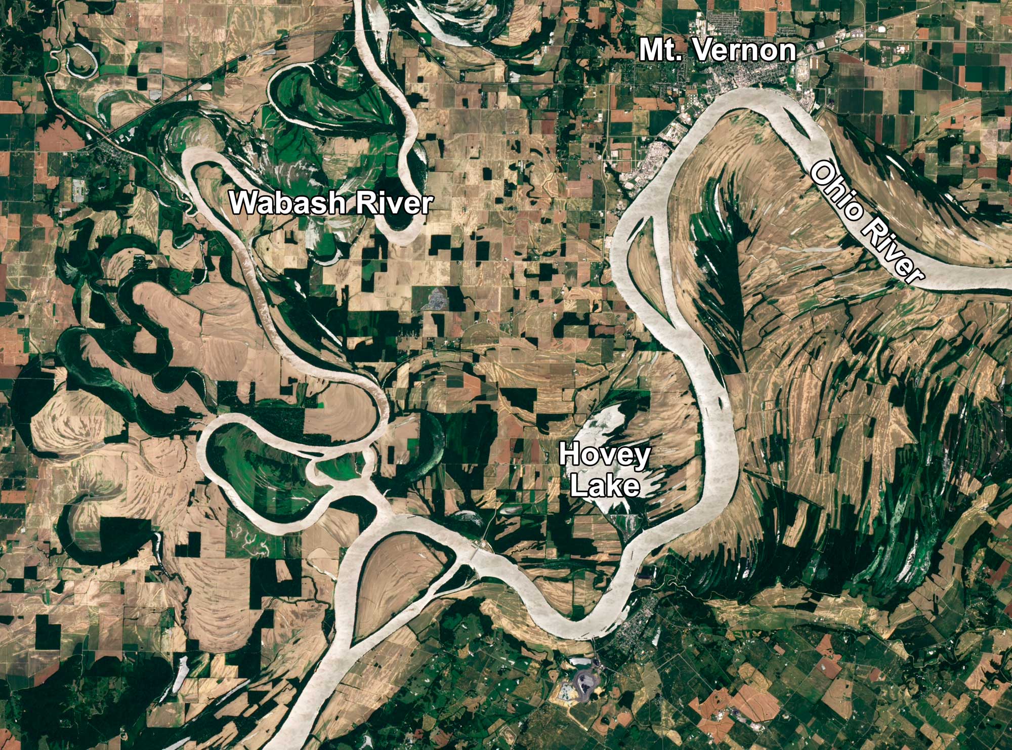
Satellite image of the confluence of the Ohio and Wabash Rivers in Indiana. Source: NASA Earth Observatory image created by Robert Simmon (used following NASA's image use policy).
The Great Lakes
The Great Lakes are a prominent geologic feature of the Midwest and include three of the five largest lakes in the world: Lake Superior, Lake Michigan, and Lake Huron. In fact, the Great Lakes contain 21% of the world’s fresh water.
A mere 20,000 years ago, the Great Lakes did not exist. At that time, the ice sheets extended well past where the lakes would now occur. The Great Lakes were actually river valleys that were scoured and deepened repeatedly by the numerous ice advances during the Quaternary period. As the glacier retreated and the basins filled with glacial runoff, the still-forming lakes drained southward, eventually into the Mississippi River.
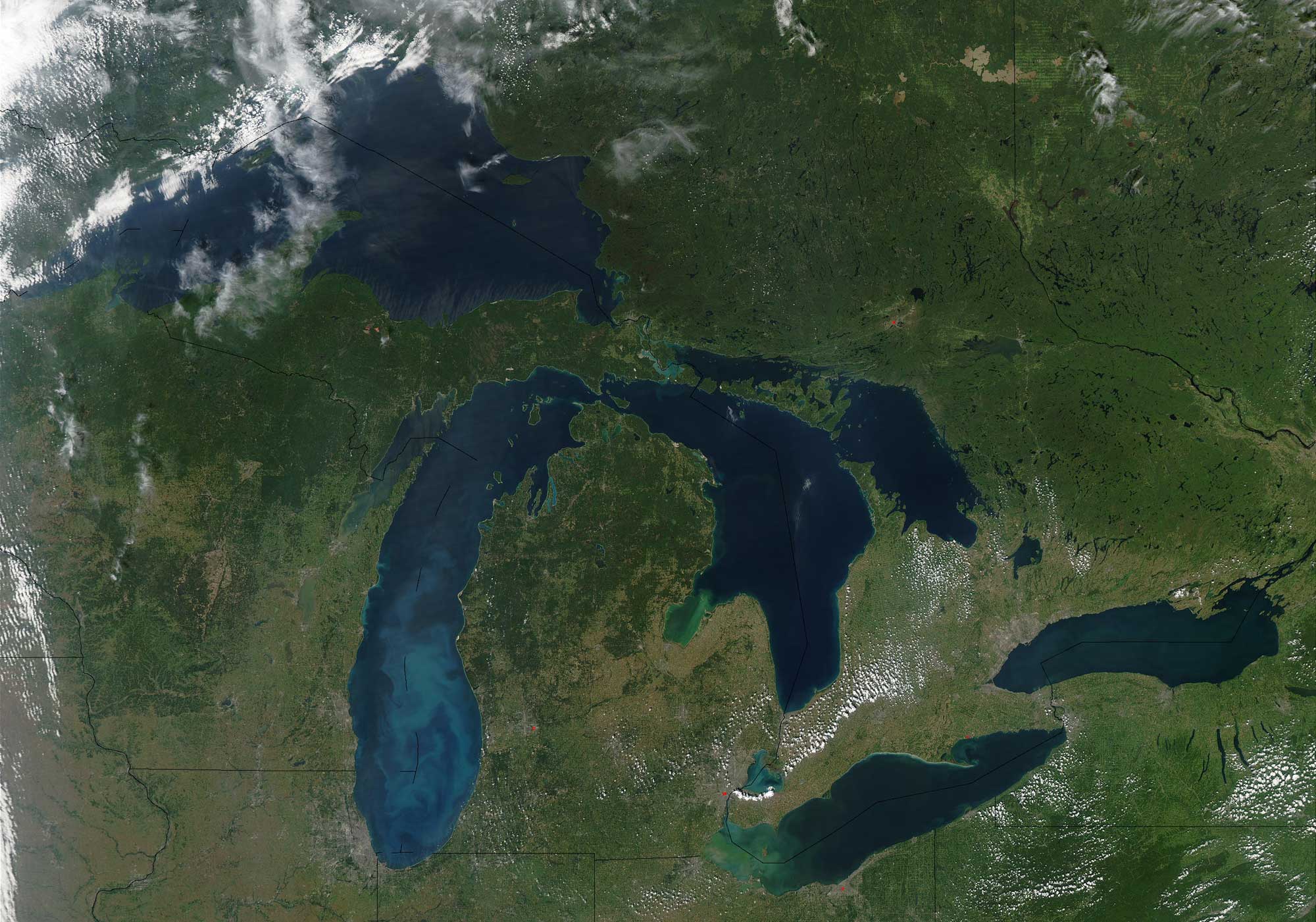
Satellite image of the Great Lakes region of North America. Photo by Jeff Schmaltz, MODIS Rapid Response Team, NASA/GSFC (NASA Visible Earth, used following NASA's image use policy).

Diagram showing the relative elevations and depths of the Great Lakes. Source: NOAA (NOAA Great Lakes Environmental Research Laboratory on flickr, Creative Commons Attribution-ShareAlike 2.0 Generic license).
Pleistocene deposits
Glacial deposits
All of Michigan (lower and upper peninsulas), most of Minnesota, northern and eastern Wisconsin, and portions of Illionois, Indiana, Iowa, and Ohio were covered by the southern part of the Laurentide Ice Sheet during the Wisconsinan glaciation, the most recent Pleistocene glaciation. Older glacial deposits are also found in the Midwest region, including Pre-Illinoian deposits in Illinois, Iowa, Minnesota, and Wisconsin, as well as Illinoian deposits in in Illinois, Indiana, Iowa, Ohio, and Wisconsin.
The Prairie Pothole Region that covers western Minnesota and north-central Iowa (extending into the eastern parts of the Dakotas, north-central to northeastern Montana, and north into Canada) is a region that was reached by the Laurentide ice sheet during the last glacial maximum (Wisconsinan glaciation, 85,000–11,000 years ago). This large region is characterized by glacial deposits and its large number of "prairie potholes" or kettle lakes. Much of the land in the prairie pothole region in Minnesota and Iowa has been converted to agricultural use, so many of the potholes have been drained. Some pothole complexes that have not been modified or have been restored are protected areas for waterfowl.
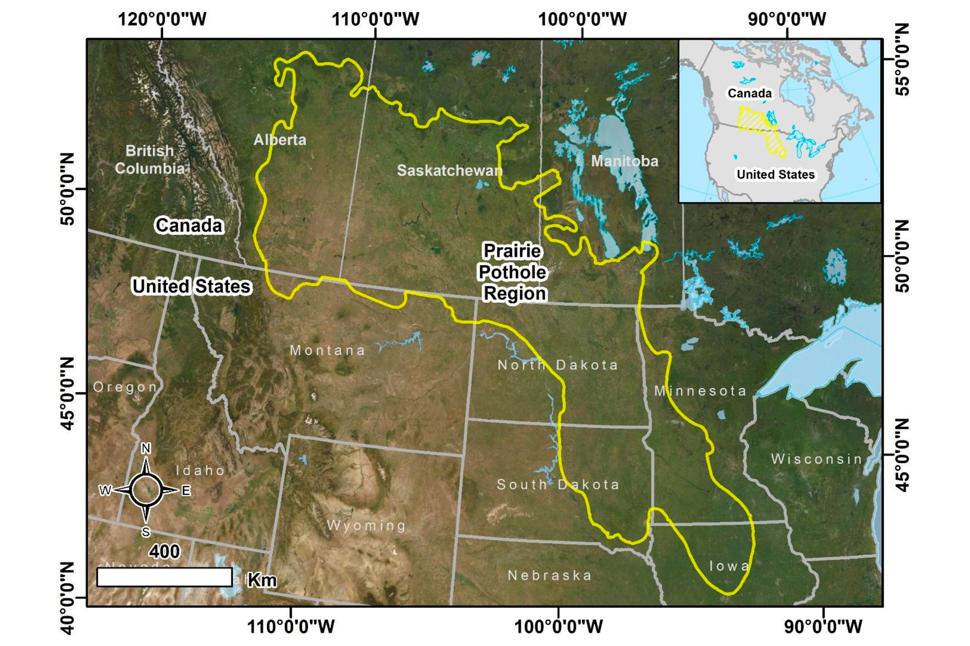
Map showing the extent of the Prairie Pothole region of south-central Canada and the north-central U.S.A. This area includes many praire potholes or kettle lakes that were created when the late Pleistocene continental ice sheets retreated. Source: Figure 1 from Montgomery et al. (2021) Remote Sensing (Creative Commons Attribution 4.0 International license, image resized).
To the east of the Prairie Pothole Region, the previously glaciated portions of the Midwestern states show the typical types of deposits and landforms shaped by glaciers: kames, kettle lakes, drumlins, eskers, moraines, and glacial erratics.
In areas where the bedrock is not covered by glacial sediments, grooves and marks (like scratches) left by glaciers sliding over rocks can be observed.
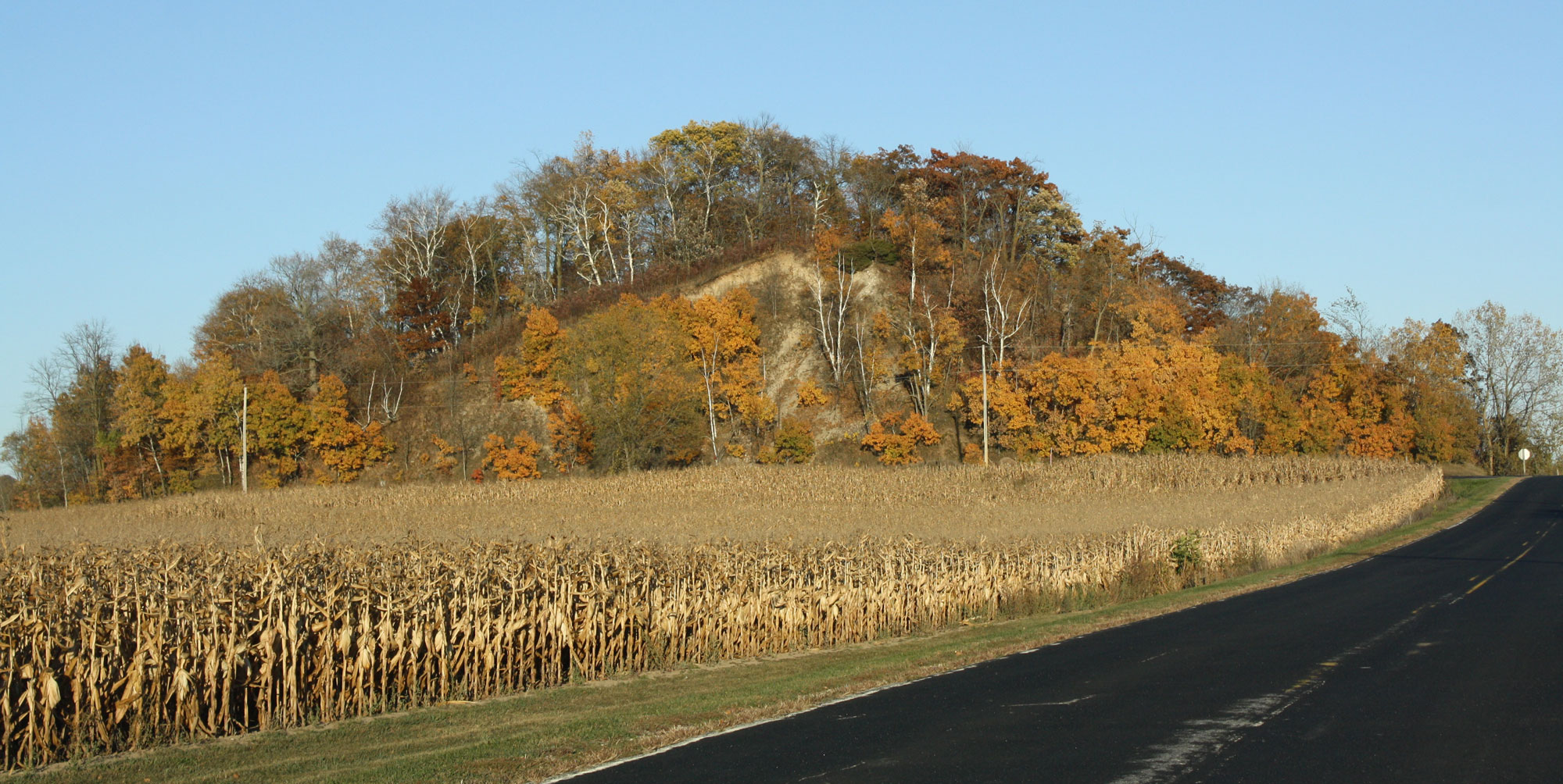
A kame (the rounded hill in the background), Kettle Moraine region, Fond du Lac County, Wisconsin. Photo by Royal Broil (flickr, Creative Commons Attribution-ShareAlike 2.0 Generic license, image cropped and resized).
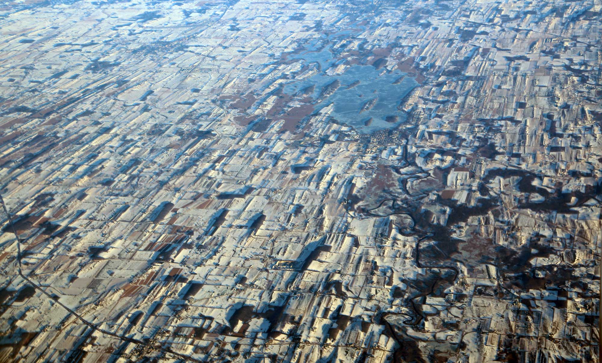
Aerial photo of drumlins near Horicon Marsh, Wisconsin, in the winter (December 2016). The drumlins, some of which appear dark because patches of forest occur on them, make the landscape look grooved. Photo by Doc Searls (flickr, Creative Commons Attribution 2.0 Generic license, image resized).
Loess
Much of the soil throughout the Midwest is composed, in part, of sediment blown from the huge mudflats on the banks of the ancient Missouri River, which was a major channel for floods of glacial meltwater. The Peoria Loess (windblown rock flour), which dates to the Wisconsinan glacial interval, covers much of Illinois, Indiana, Iowa, and Wisconsin, as well as southeastern and southwestern Minnesota and southern Ohio. In most areas, this loess is 1 to 5 meters (3.3 to 16.4 feet) thick, although the loess deposits are much thicker in western Iowa.
The Loess Hills
The Loess Hills of extreme western Iowa and northwestern-most Missouri are made up of loess deposits that exceed 20 meters (65.6 feet) in thickness. Hills made up of glacial loess are found in only a few places on Earth.
The Loess Hills form a very narrow, 320-kilometer (200-mile) long, north-south band immediately east of the Missouri River floodplain. The hills stand more than 60 meters (200 feet) above the surrounding low farmland and often display very sharp profiles, having been cut away into steep bluffs.
The Loess Hills were formed during several glacial-interglacial cycles. First, glaciers ground down the underlying bedrock. Then, as the ice retreated, meltwater deposited these fine sediments in expansive mudflats. When the mudflats dried, strong westerly winds blew the sand into great dunes; the finest material (silt and clay) was carried the furthest in massive dust clouds. The dunes were eventually stabilized by vegetation and matured into the hills, but the loose material of the hills is still easily eroded and carved. Slumping, mudslides, and undercutting caused by wind and water have produced steep slopes and a landscape of narrow ridges.
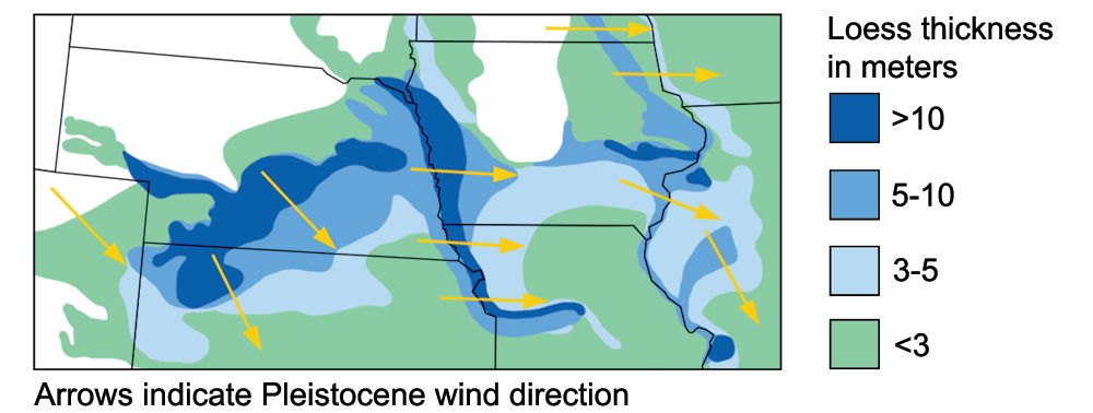
Loess deposits in the Loess Hills and surrounding region. Image adapted from a figure by the USGS.
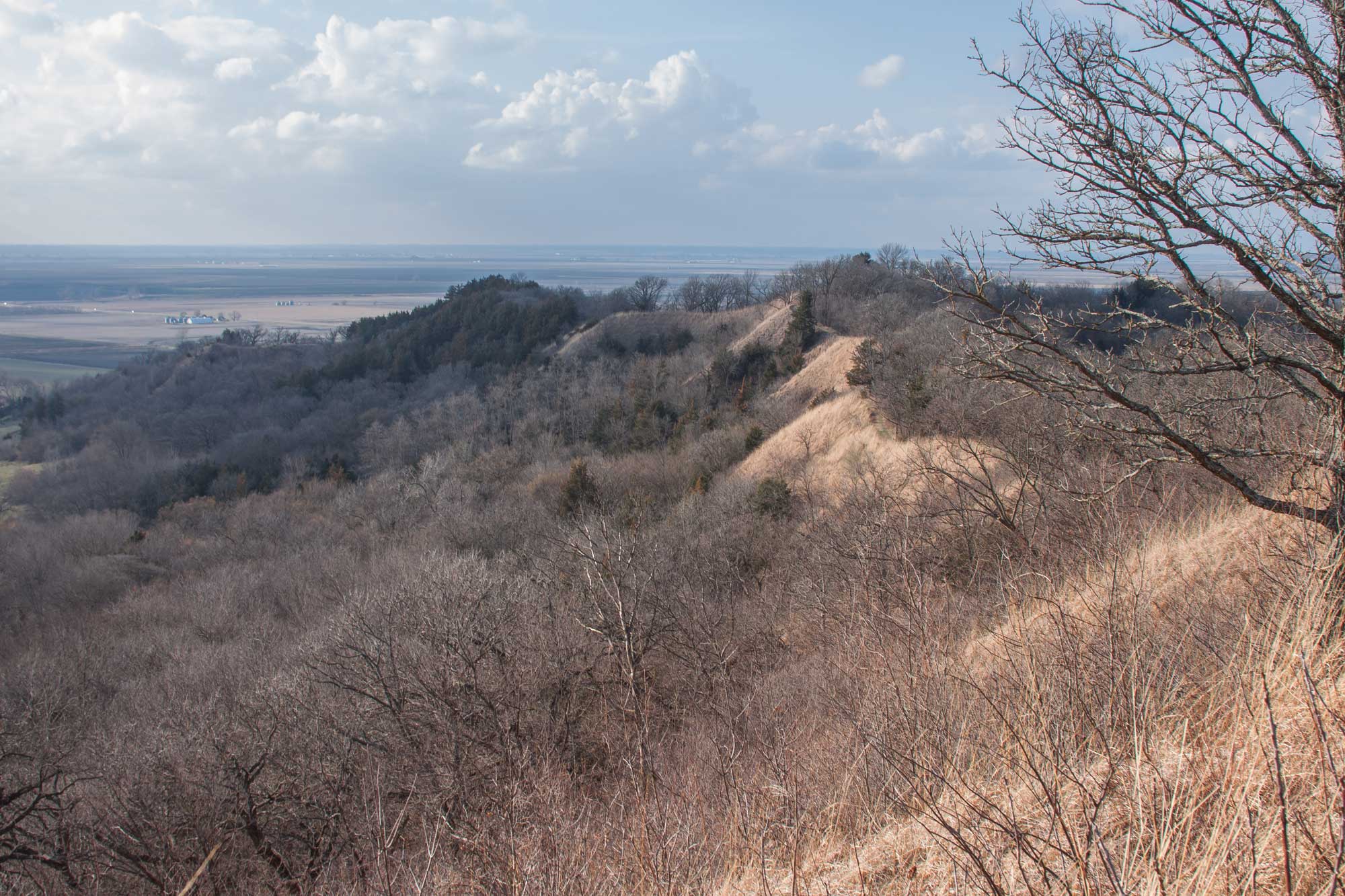
Loess Hills, Waubonsie State Park, Iowa. Loess is made up of fine-grained aeolian (wind-blown) sediment. The sediment that makes up the Loess Hills was originally transported in meltwater from Pleistocene glaciers, then blown into thick deposits by wind. The large continental glaciers that helped form the Loess Hills have long since disappeared from North America. Photo by Vincent Parsons (flickr, Creative Commons Attribution-NonCommercial 2.0 Generic license, image resized).
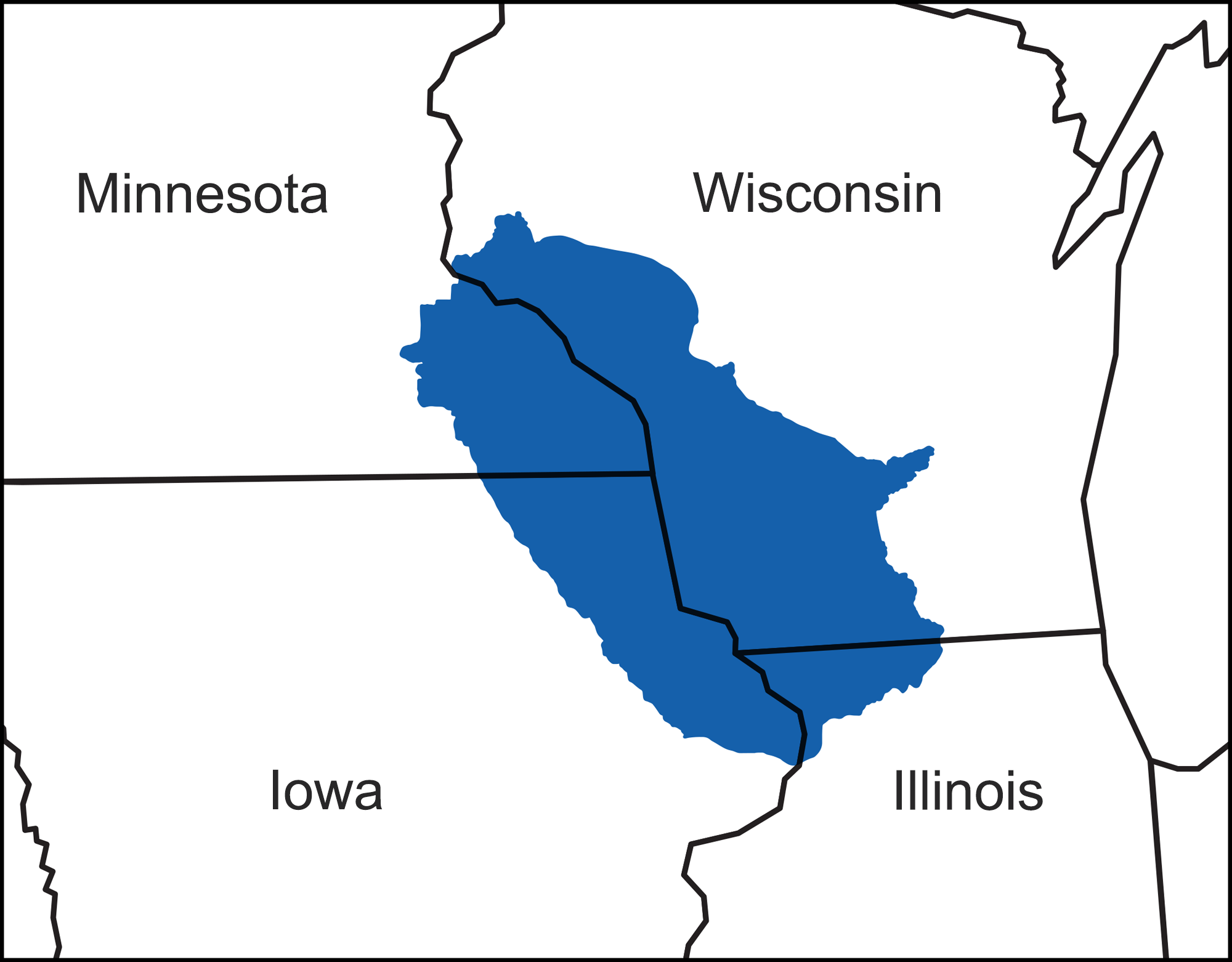
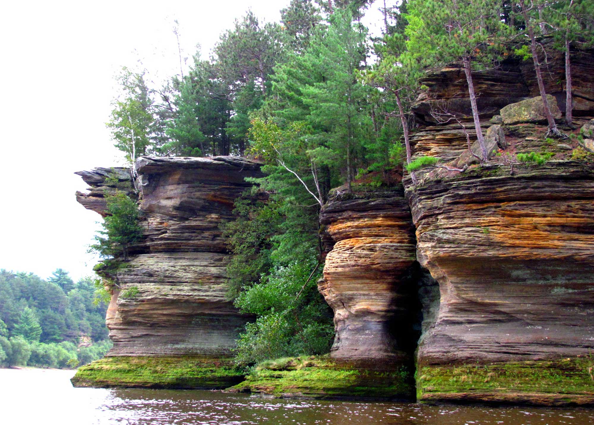
The Driftless Area
The Driftless Area, also known as the Paleozoic Plateau, is located around the upper Mississippi River valley where Minnesota, Wisconsin, Iowa, and Illinois meet. The Driftless Area was completely missed by the advancing ice during the Pleistocene, so the landscape in this region is suggestive of what the rest of the Midwest might have looked like before glaciers leveled it. The deep valleys, steep bluffs, and high hills of the Driftless Area stand in stark relief to the flat plains surrounding it.
Map showing the extent of the Driftless Area in the midwestern U.S. Adapted from figures by David C. Wilson.
Glacial Lake Wisconsin
Glacial Lake Wisconsin formed during the last glacial interval (the Wisconsinian) of the Pleistocene when glacial ice formed a natural dam on the Wisconsin River. The lake drained suddenly when the ice dam holding back the water failed about 14,000 years ago. The breech of the dam released a massive volume of water into the Wisconsin River, causing an outburst flood that scoured and shaped the landscape. The floodwaters carved through Cambrian sandstone, creating the cliffs of the Wisconsin Dells. The lakebed of Glacial Lake Wisconsin is today found in the Central Sand Plains region of Wisconsin.
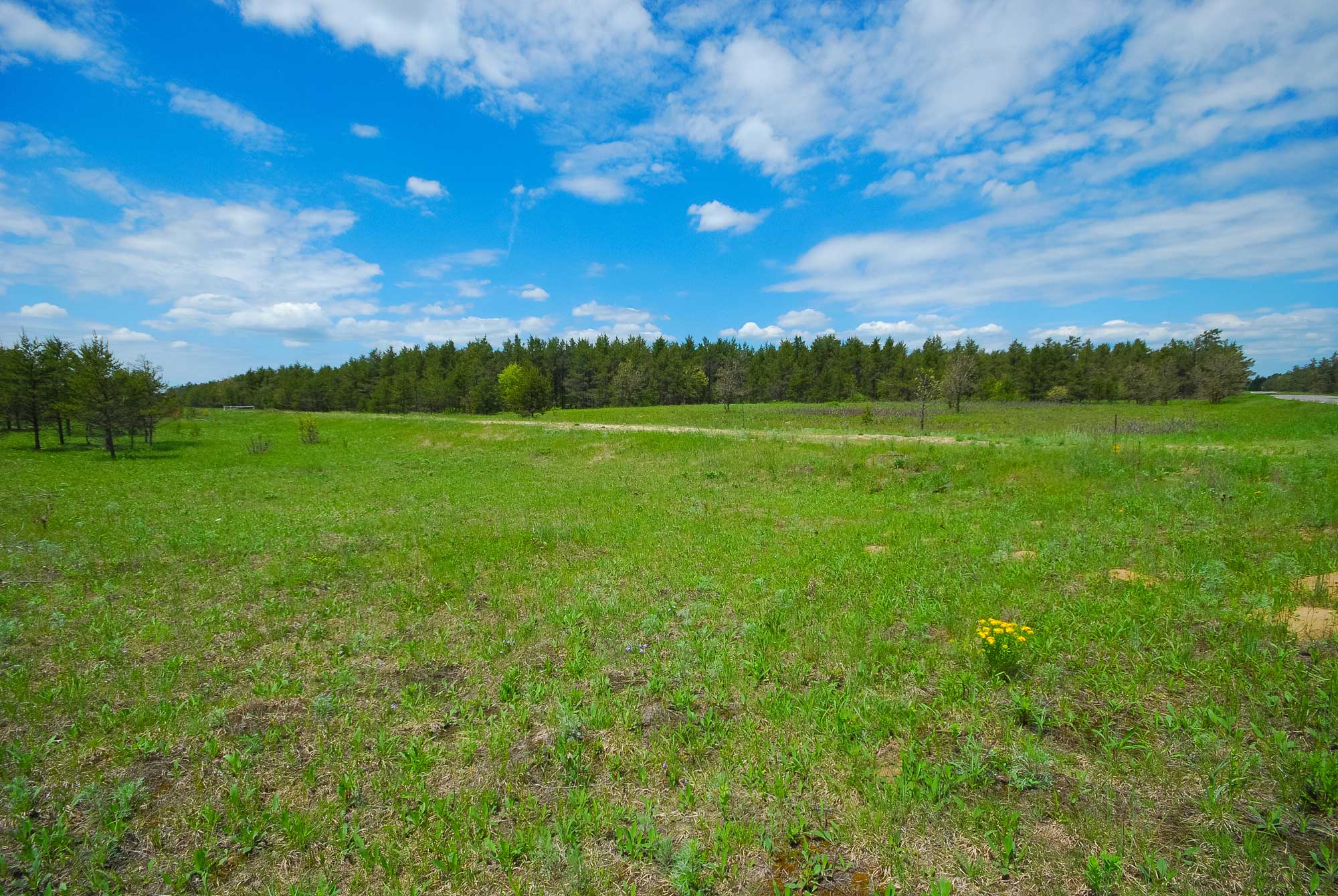
Bauer-Brockway Barrens Wisconsin State Natural Area, Central Sand Plains region, Wisconsin. Photo by Joshua Mayer (Wikimedia Commons, Creative Commons Attribution-ShareAlike 2.0 Generic license, image resized).
Wisconsin Dells. The Cambrian sandstone cliffs were carved by floodwaters from the draining of Glacial Lake Wisconsin. Photo by Jeremy Thompson (flickr, Creative Commons Attribution 2.0 Generic license, image cropped and resized).
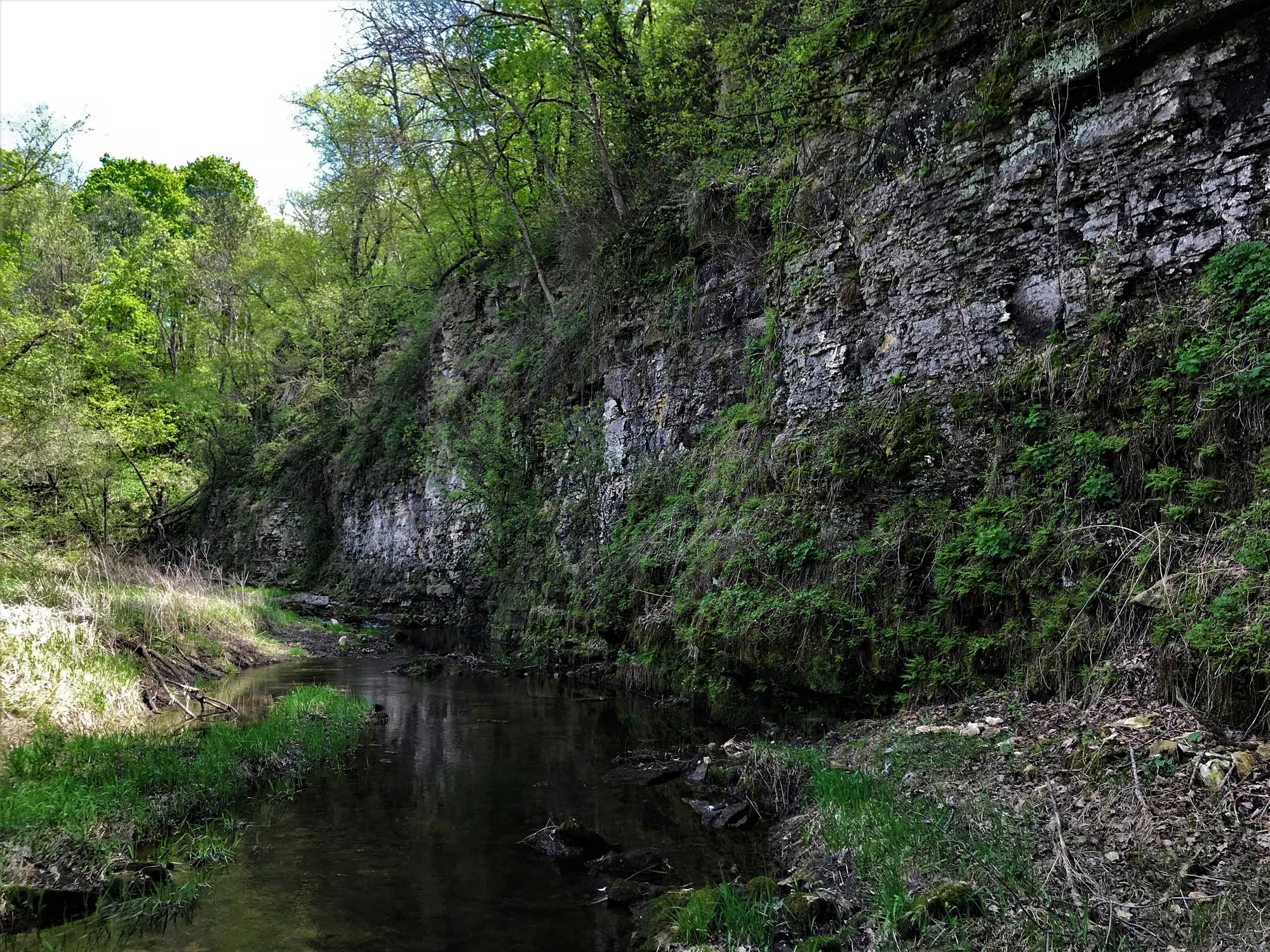
Algific talus slopes
The Driftless Area’s topography is largely controlled by the water flowing through it, which has been carving into its rock for millions of years. The Driftless Area is an example of karst topography, a kind of landscape defined by bedrock that has been weathered by dissolution in water, forming features like sinkholes, caves, and cliffs. Here, cold underground lakes create a kind of natural air conditioning; air is cycled into cracks and caves in the rock, where it is cooled by the water before returning to the surface. This unique geologic phenomenon, coupled with cliffs that block much of the sunlight, make microhabitats that are tens of degrees cooler than the surrounding area just yards away. These habitats are called algific talus slopes.
Algific talus slopes are scattered across the Driftless Area, but are found nowhere else on earth. They tend to occur only on the northern sides of hills, where they receive very little sunlight. They are home to unique flora and fauna. Some species living on the algific talus slopes are typically found much farther north, and some of which are not found anywhere else.
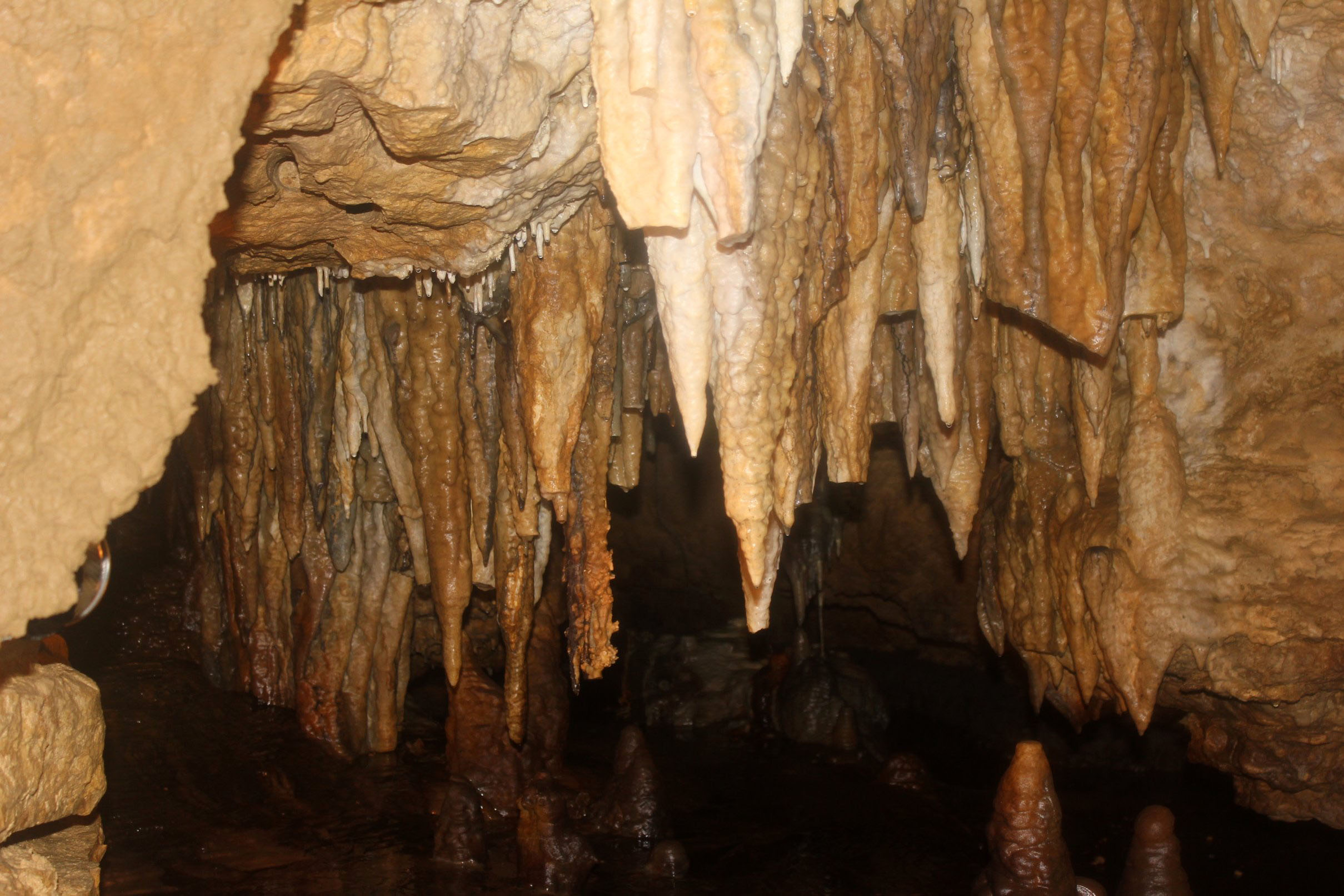
Stalactites in Cave of the Mounds, Blue Mound, Wisconsin. Photo by Yinan Chen (Wikimedia Commons, public domain dedication).
Algific talus slope, Howard Creek, Driftless Area National Wildlife Refuge, eastern Iowa. Photo by Brandon Jones/USFWS (USFWS Midwest Region on flickr, public domain).
"Algific Talus Slopes." Video by Iowa Land and Sky (via YouTube).
For example, the Iowa Pleistocene snail (Discus macclintocki) was abundant throughout the Midwest during much of the Pleistocene epoch. At one time, it was only known from the fossil record and was thought to have gone extinct after the last glacial maximum. However, it was discovered alive and well in 1955. It survives today scattered among a few dozen algific talus slopes in five counties in Iowa and one in Illinois. It is currently classified as an endangered species.
Another species found on these slopes is the northern monkshood (Aconitum noveboracense), which is a threatened species. This plant is known only from the Driftless Area of Iowa and Wisconsin, a few regions in Ohio (including the Hocking Hills, another unglaciated area of the Midwest), and a small region of New York.
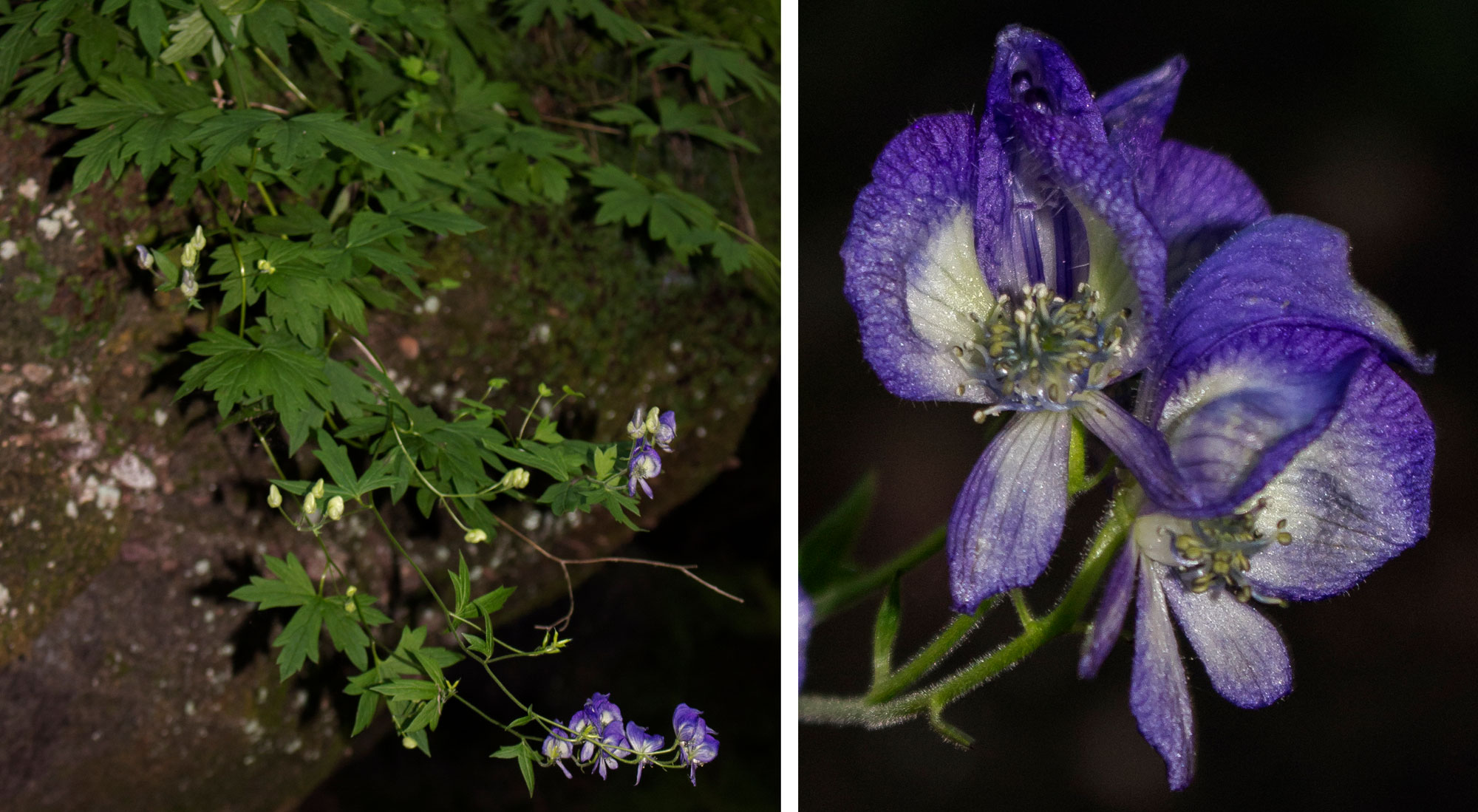
Northern monkshood (Aconitum noveboracense), Baraboo region, Wisconsin. Photos by aarongunnar (iNaturalist, Creative Commons Attribution 4.0 International license, images cropped and resized).
Resources
Resources from the Paleontological Research Institution
Earth@Home: Here on Earth: Introduction to Glaciers: https://earthathome.org/hoe/glaciers/