

Page snapshot: Introduction to glaciers.
Topics covered on this page: Introduction; Glacial landscapes; Periglacial environments; The Quaternary period
Credits: Most of the text of this page comes from from "Glaciers in the South-central US" by Alex F. Wall and Robert M. Ross, chapter 6 in The Teacher-Friendly Guide to the Earth Science of the South Central US, edited by Mark D. Lucas, Robert M. Ross, and Andrielle N. Swaby (published in 2015 by the Paleontological Research Institution; currently out of print). Some additional text comes from "Glaciers in the Western US" by Frank D. Granshaw, chapter 6 in The Teacher-Friendly Guide to the Earth Science of the Western US, edited by Mark D. Lucas, Robert M. Ross, and Andrielle N. Swaby (published in 2014 by the Paleontological Research Institution). These books were adapted for the web by Elizabeth J. Hermsen and Jonathan R. Hendricks in 2022. Changes include formatting and revisions to the text and images. Credits for individual images are given in figure captions.
Updates: Page last updated August 12, 2022.
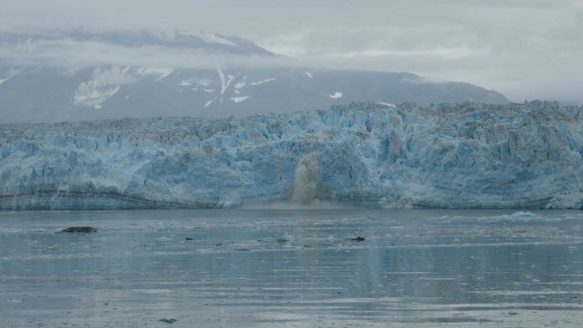
Image above: Ice calving off of Hubbard Glacier into Disenchantment Bay, Alaska. Photograph by Jonathan R. Hendricks.
Introduction
What is a glacier?
A glacier is a large mass of ice (usually covered by snow) that is heavy enough to flow like a very thick fluid. Glaciers form in areas where more snow accumulates than is lost each year. A cold climate and sufficient moisture in the air for the precipitation of snow are both necessary factors that permit at least some snow to last year round. As new snow accumulates, it buries and compresses old snow, transforming it from a fluffy mass of snowflakes into ice crystals with the appearance of wet sugar, known as firn. As this firn is buried deeper, it coalesces into a mass of hard, dense ice that is riddled with air bubbles. Much of this transformation takes place in the high part of a glacier where annual snow accumulation outpaces snow loss, a place called the accumulation zone.
At a depth greater than about 50 meters (165 feet), the pressure is high enough for plastic flow to occur. Ice flow is driven by gravity, and it causes movement downhill and out from the center.
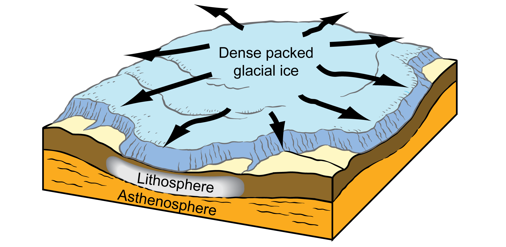
As dense glacial ice piles up, a glacier is formed. The ice begins to move under its own weight and pressure. Image by Jim Houghton; modified for the Earth@Home project.
Once the ice becomes thick enough, it flows outward to the ablation zone, where ice is lost due to melting and calving.
The boundary between the accumulation and ablation zones, the equilibrium line, is found where annual ice accumulation equals annual ice loss. Because the altitude of this line is dependent on local temperature and precipitation, glaciologists frequently use it to assess the impact of climate change on glaciers.
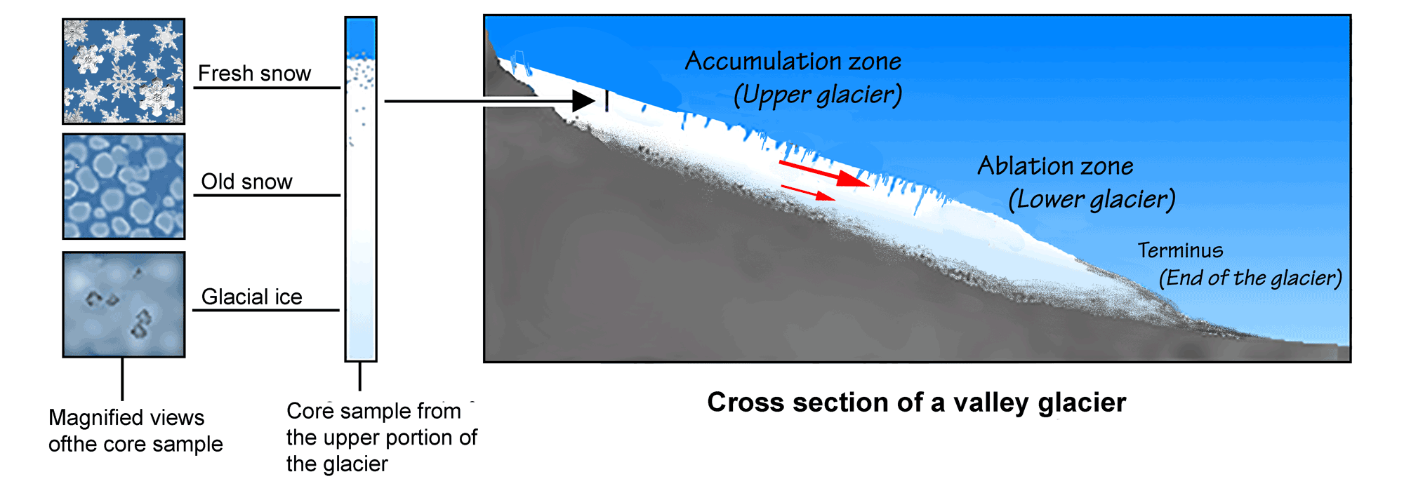
Cross section of an alpine (valley) glacier showing snow being converted into glacial ice and the two major zones of a glacier’s surface. The red arrows show the direction and relative speed of different parts of the glacier. The longer the arrow, the faster the ice is moving. Image by Frank Granshaw; modified for the Earth@Home project.
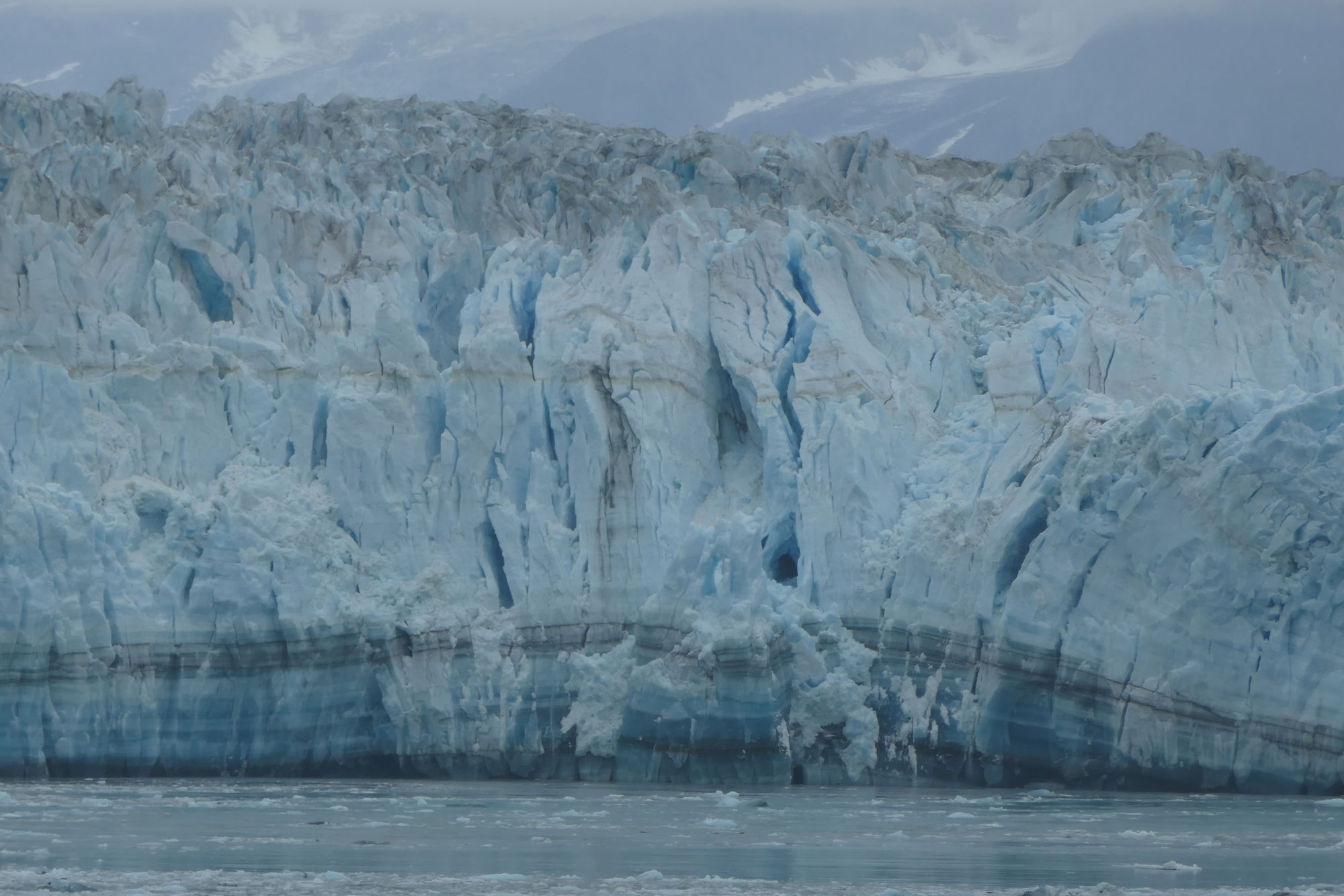
Hubbard Glacier, Alaska. Ice calves from the glacier into Disenchantment Bay. Photograph by Jonathan R. Hendricks.
Types of glaciers
Most broadly, there are two types of glaciers: smaller alpine glaciers and larger continental glaciers. While only these two broadest categories of glaciers are discussed below, glaciers exist in a variety of forms, and even these broadest of distinctions are not quite so clear-cut. For example, continental glaciers often have tongues that feed into valleys, which may become alpine glaciers.
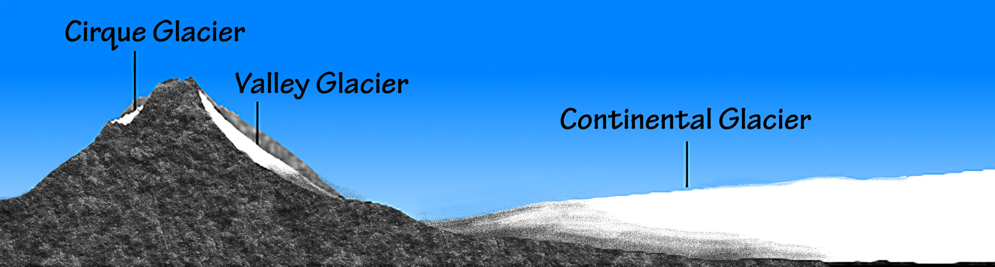
The cirque and valley glaciers shown here are types of alpine glaciers. Both alpine and continental glaciers flow downhill. Although this is obvious with an alpine glacier, it is not as much so with a continental glacier. In the case of the latter, the glacier fl ows from its thicker middle to its lower edges. Image by Frank Granshaw; modified for the Earth@Home project.
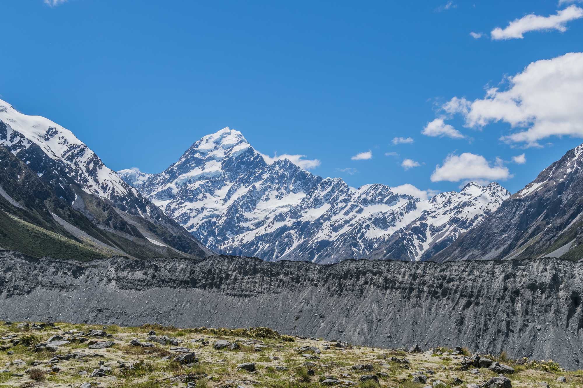
Alpine glaciers
Found in mountainous areas, alpine glaciers have a shape and motion that is largely controlled by topography, and they naturally flow from higher to lower altitudes. Glaciers confined to valleys are called valley glaciers, whereas bowl-shaped depressions called cirques are located in mountainous areas.
Glaciers are sometimes called the “canary in the coal mine” when it comes to climate change. This is because alpine glaciers are highly sensitive to changes in climate. For instance, a glacier grows (advances) when it accumulates more ice than it loses from melting or calving. Advances tend to happen when cold, wet years dominate the local climate. On the other hand, a glacier will shrink (retreat) during warm, dry periods as it loses more ice than it gains each year.
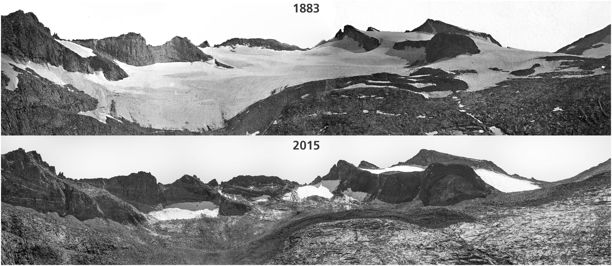
Lyell Glacier in 1883 compared to Lyell ice patch in 2015, Yosemite National Park, California. Photos by Israel Russell/USGS (1883) and Keenan Takahashi/NPS (2015). Source: NPS Climate Change Response on flickr (public domain).
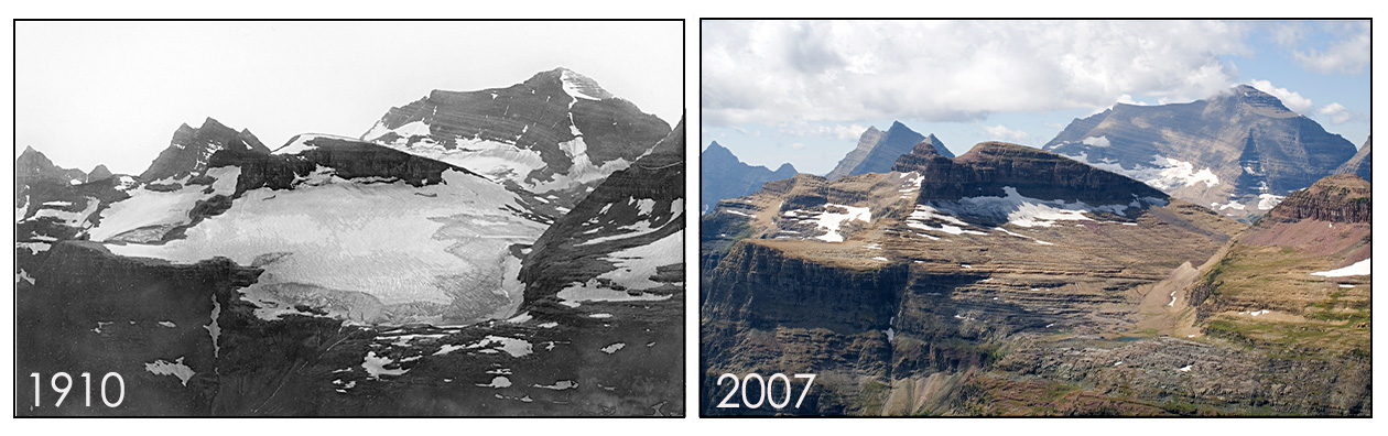
Boulder Glacier in 1910 and 2007, Glacier National Park, Montana. Photos by Morton Elrond/University of Montana Collection (1910) and Fagre/Pederson/USGS (2007). Source: USGS (public domain).
Continental glaciers
Continental glaciers are much larger than alpine glaciers. They are also less controlled by the landscape, tending to flow outward from their center of accumulation. Today, continental glaciers, also called ice sheets, are found in the high-latitude polar regions of Greenland and Antarctica where temperatures are low most of the year. There must be landmasses at high latitudes for continental glaciers to occur, as by definition glaciers cannot form over open water. (While persistent sea ice can and does form, the fact that it floats prevents it from flowing as a glacier does.) The glaciers that stretched over northern North America as recently as 20,000 years ago were primarily continental ice sheets.
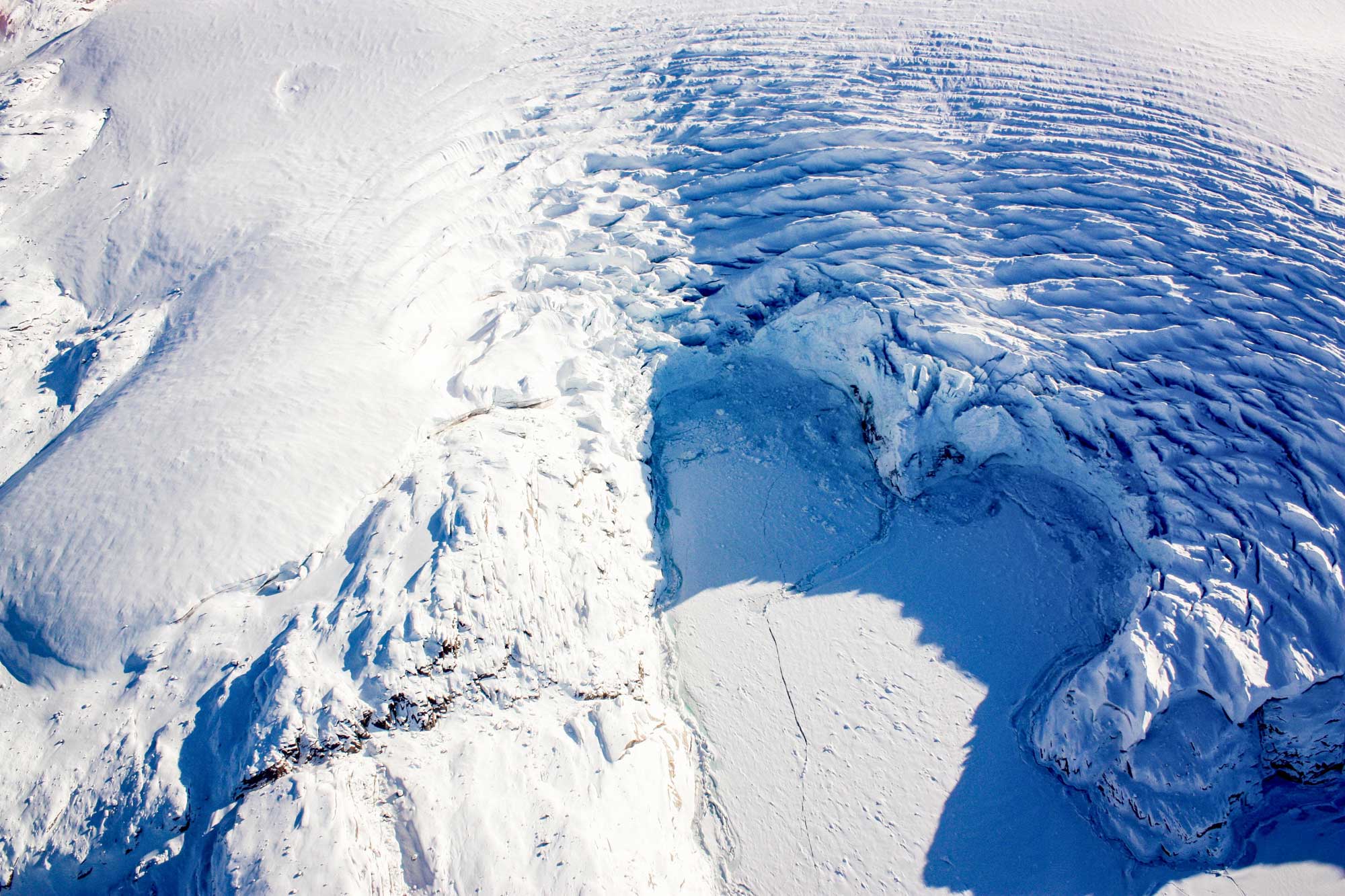
Calving of ice from the edge of a glacier in Greenland, March 27, 2017. Source: NASA/Maria-Jose Viñas (used following NASA's image use policy).
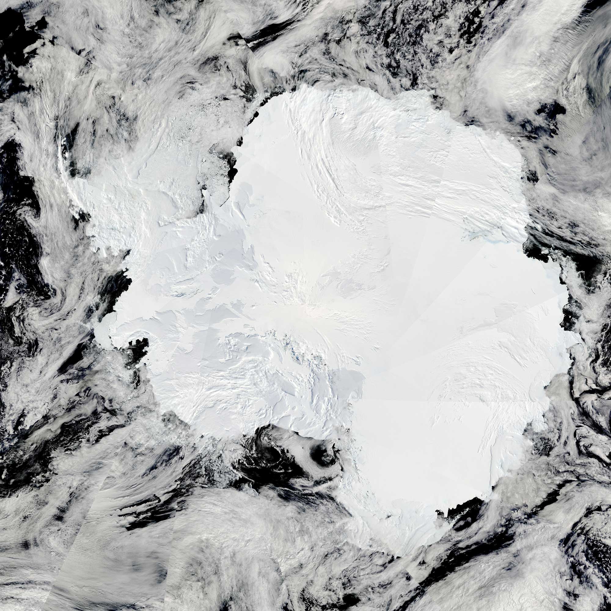
Satellite photo of Antarctica taken on January 27, 2009. Source: NASA Earth Observatory (used following NASA's image use policy).
Glacial landscapes
The interaction of glaciers with the landscape is a complex process. Glaciers alter landscapes by eroding, transporting, and depositing rock and sediment. Scouring abrades bedrock and removes sediment, while melting causes the ice to deposit sediment.
Continental glaciers also affect the landscape by depressing the Earth’s crust with their enormous mass, just as a person standing on a trampoline will cause the center to bulge downwards. The effect is quite substantial, with surfaces being lowered by hundreds of meters. Of course, this means that when the glacier retreats and the mass is removed, the crust will rise to its former height in a process known as isostasy. Dramatic results include marine reefs lifted high above sea level and marine sediments composing coastal bluffs.
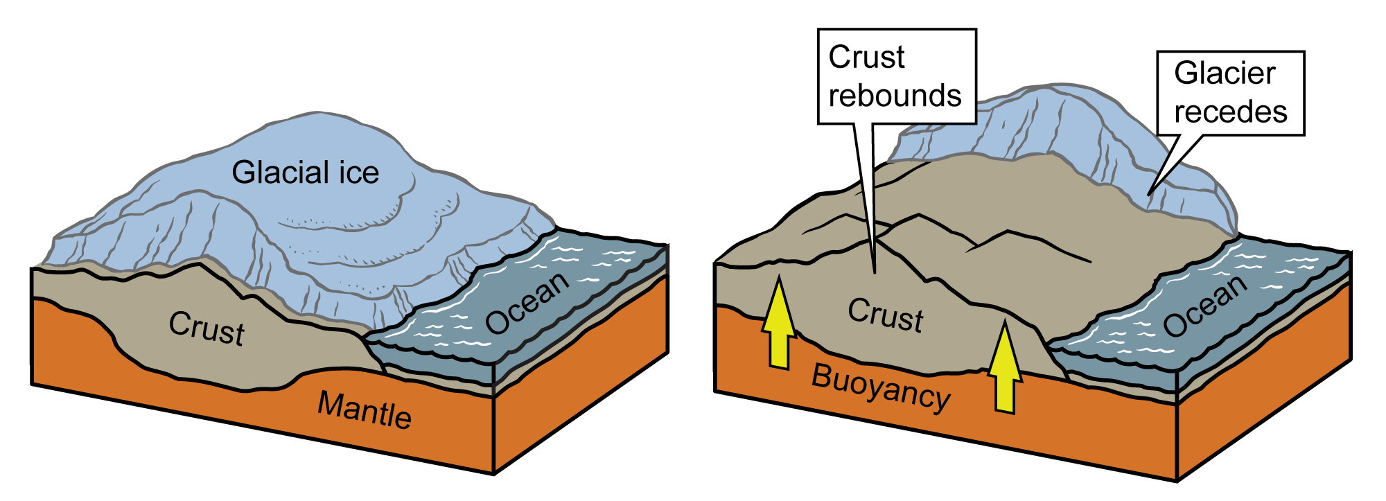
Isostatic rebound resulting from glacial retreat. Image by Jim Houghton, modified for the Earth@Home project.
Erosion
Thousands of years of scraping by ice can have dramatic, and sometimes dramatically varied, effects on a landscape. Glaciers erode the land they flow over via abrasion and plucking. Harder bedrock will be scratched and polished by sediment stuck in the ice, while frost wedging—water freezing and expanding in cracks—can eventually break chunks of rock away. Softer bedrock is much more easily carved and crushed.
Glacial erosion can produce rugged mountainous areas with knife-edge ridges (arêtes), pointed rocky peaks (horns), and bowl-shaped depressions (cirques). These landscapes are most visible in areas where glaciers have retreated.
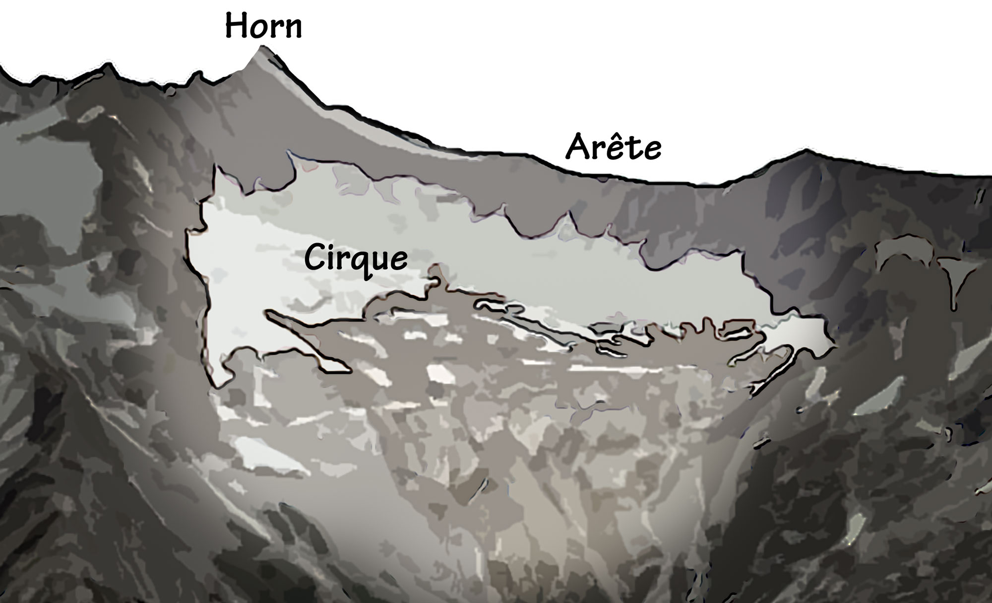
Glacial features in Cascade Pass, North Cascades National Park, Washington.
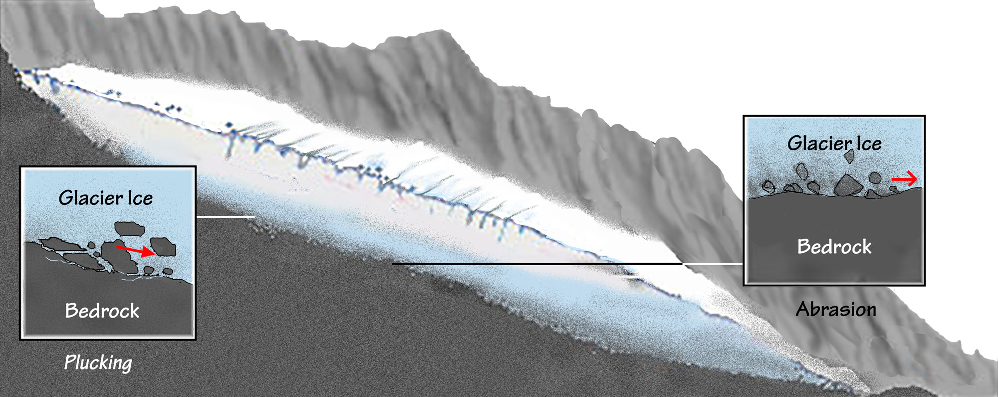
Abrasion, or scouring, occurs when rock fragments in the ice erode bedrock as the glacier moves over it. Plucking involves glaciers pulling chunks of rock away from underlying bedrock. The flowing ice cracks and breaks rock as it passes over, pieces of which become incorporated into the icesheet or bulldozed forward, in front of the glacier’s margin. The less resistant rock over which glaciers move is often eroded and ground-up into very fine sand and clay (called rock flour). Once eroded, this material is carried away by the ice and deposited wherever it melts out.
Rock and sediment derived by plucking and abrasion. These loose materials are subsequently transported to a glacier’s ablation zone where they are deposited by melting ice. Image by Frank Granshaw.
More resistant igneous and metamorphic rock is often polished and scratched by the grinding action of sediments trapped in the glacial ice. Streams of meltwater from the glacier, frequently gushing and full of sediment, cause significant amounts of scour as well. The abrasive sediments in the flowing water create potholes in the bedrock and plunge pools at the base of waterfalls. At the edge of the sheet, where the ice at last succumbs to melting, the rock is finally deposited.
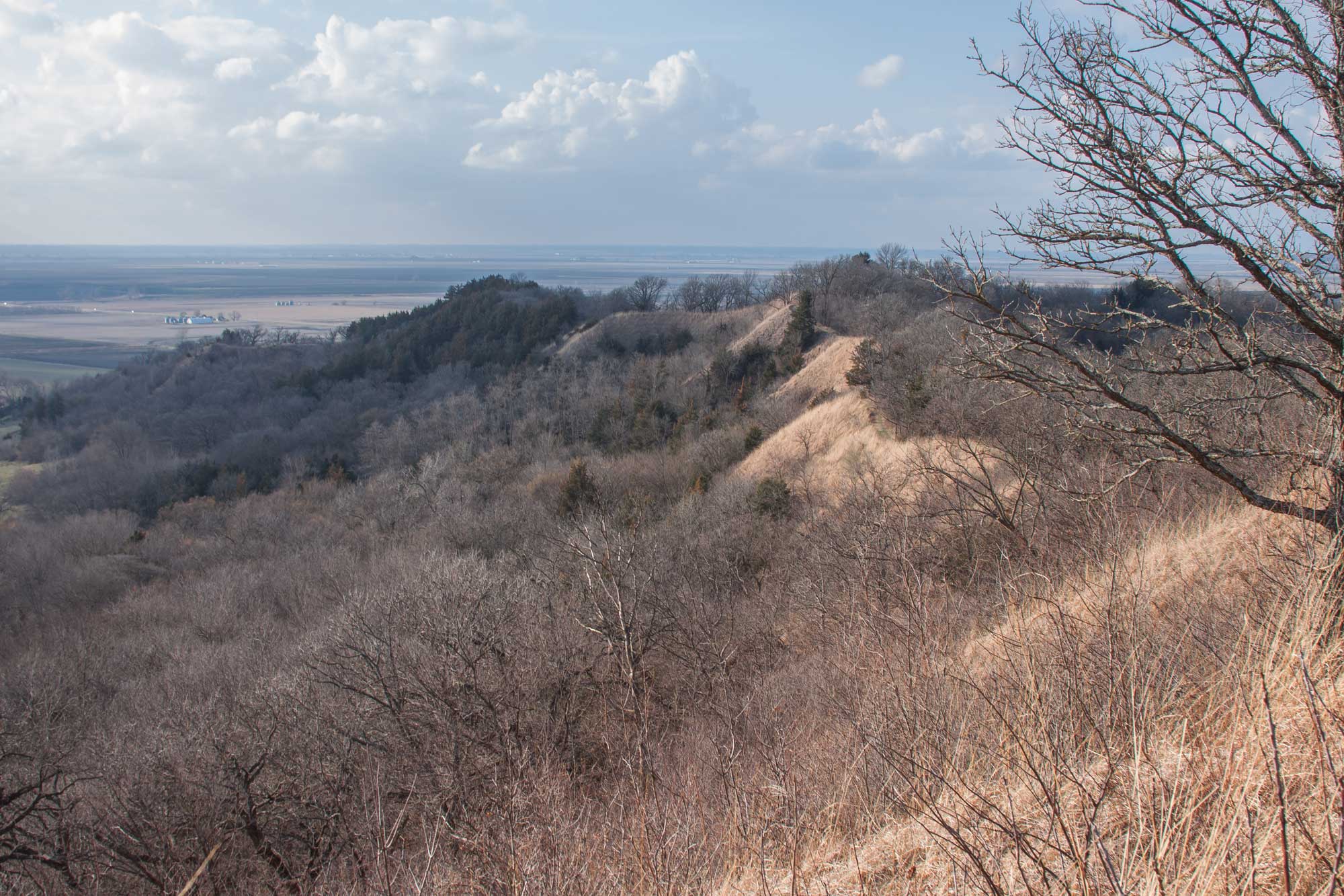
The nature of the glacier causing the erosion is also crucial. Because continental glaciers spread from a central accumulation zone, they cannot go around peaks in their path, so they instead slowly crush and scrape them away. For the most part, this results in flatter landscapes. Conversely, alpine glaciers tend to follow the existing topography, flowing downhill. This frequently causes them to scour existing low points, making them lower still. While this gouging increases the overall relief of an area, anything directly in the path of the ice is flattened. For example, a glacier might deepen a valley while surrounding peaks remain high. The glacier will smooth the valley into a distinctive U-shape.
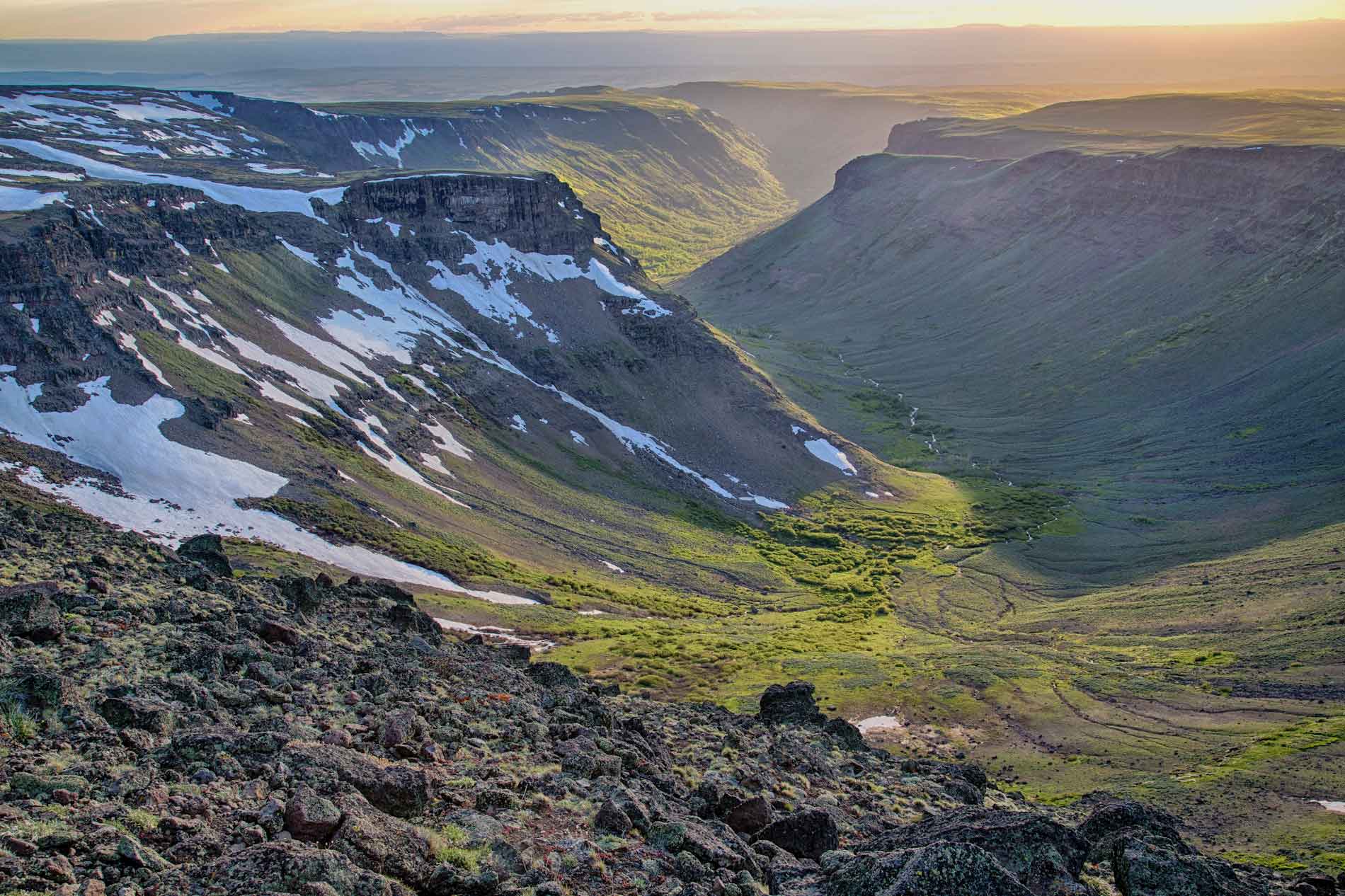
A U-shaped glacial valley on Steens Mountain, Oregon. Image by Bob Wick, Bureau of Land Managemetn (Flickr; Creative Commons Attribution 2.0 Generic license).
A river, in contrast, will erode a sharp notch, creating V-shaped valleys. As the glaciers retreat from these valleys, they leave behind thick layers of till, a chaotic mix of rock and sediment that covers the valley floor. If the valley is flooded with seawater as a glacier recedes it becomes a fjord.
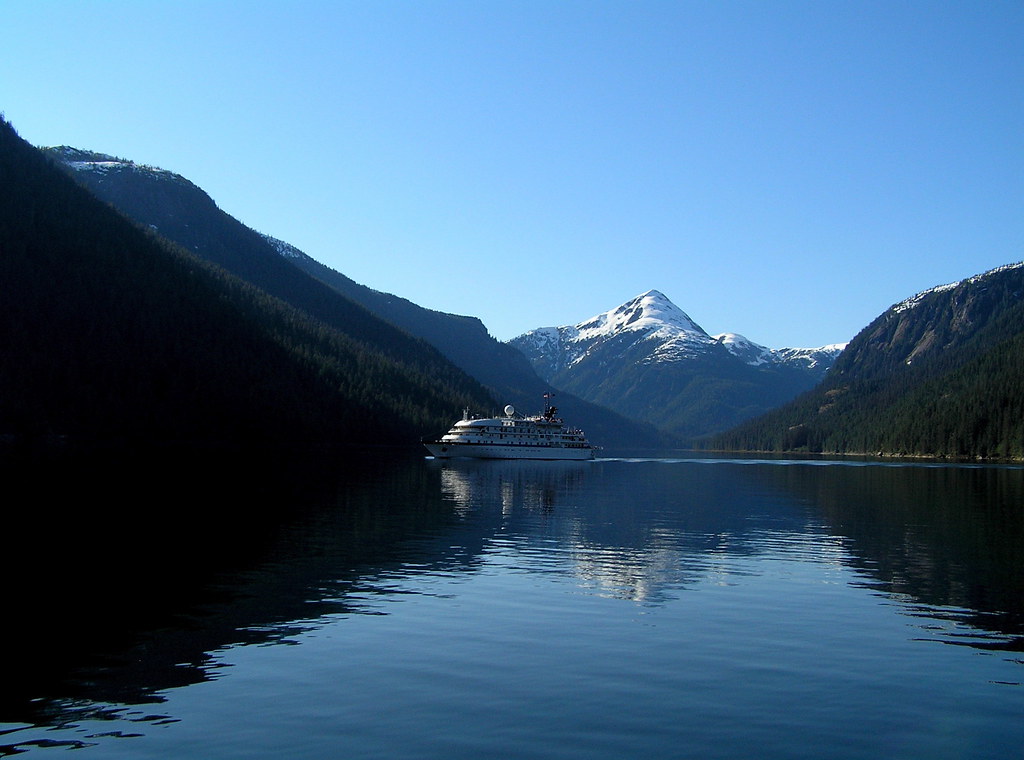
Misty Fjords National Monument in the Tongass National Forest, Alaska. Photograph by Barbara Ann Spengler (Flickr; Creative Commons Attribution-NonCommercial 2.0 Generic license).
Deposition
As glaciers scrape over the earth, sediment is incorporated into or shoved ahead of the advancing ice. The unsorted mixture of boulders, gravel, sand, silt, and clay that is picked up and later deposited by glaciers is called till. It is important to note that whether a glacier is advancing, in equilibrium, or retreating, its ice is still flowing forward, like a conveyor belt that is constantly depositing till at its margin.
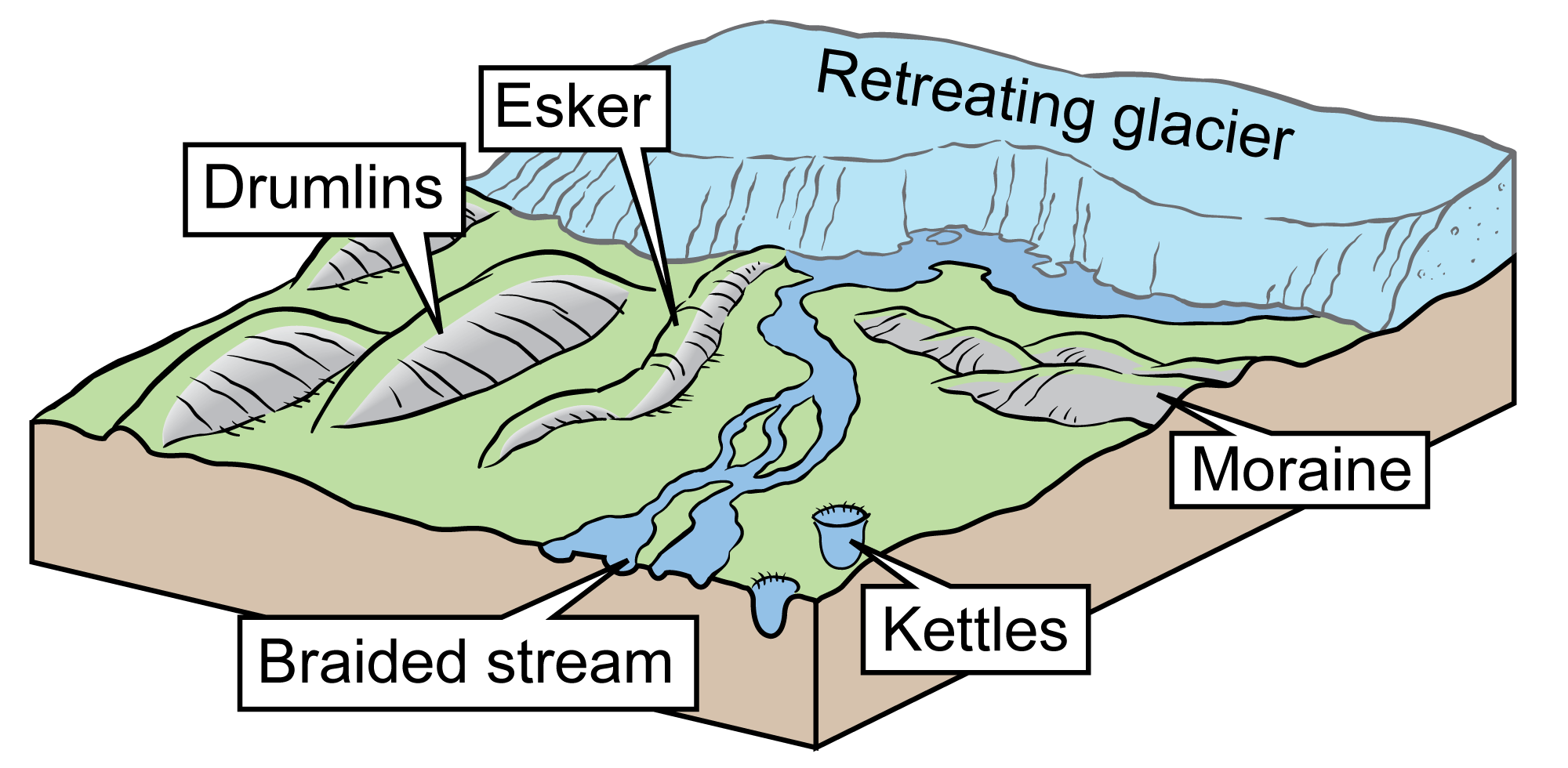
Examples of different types of glacial features. Illustration by Jim Houghton; modified for the Earth@Home project.
Moraines
In places where a glacier stopped its advance and then melted back, a ridge of till that had been pushed in front of it is left behind, marking the farthest extent of the glacier’s margin, or terminus. A ridge of till formed this way is called a terminal moraine, and it may range in length from hundreds to thousands of meters. Moraines also form on the sides of glaciers. Moraines that form on the sides of glaciers are lateral moraines.
Flowing glaciers converging in southeastern Alaska. Notice the sediment building up on the sides of the glaciers as well as the ribbons of sediment on the surfaces of the glaciers (medial moraines). Photograph by Jonathan R. Hendricks.
Mueller lateral moraine (the ridge running horizontally across the image in the foreground) with Mt. Cook in the background, Mount Cook National Park, New Zealand. Photo by Krzysztof Golik (Wikimedia Commons, Creative Commons Attribution-ShareAlike 4.0 International license, image resized).
Drumlins
A drumlin is a teardrop-shaped hill of till that was trapped beneath a glacier and streamlined in the direction of the flow of the ice moving over it. The elongation of a drumlin provides an excellent clue to the direction of flow during an ice sheet’s most recent advance.
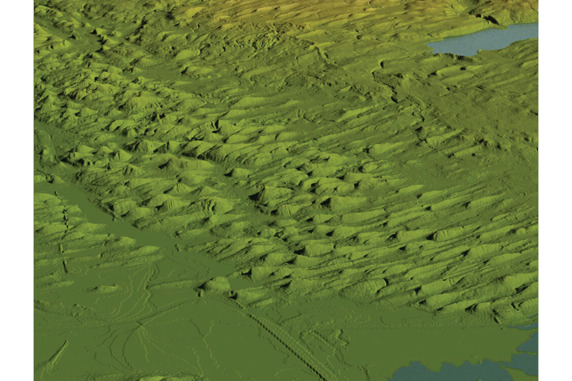
Digital elevation image of a drumlin field near Auburn, New York. Image by Rick Allmendinger (for educational use only); was published as fig. 4.9 in Gorges History: Landscapes and Geology of the Finger Lakes Region by Arthur Bloom.
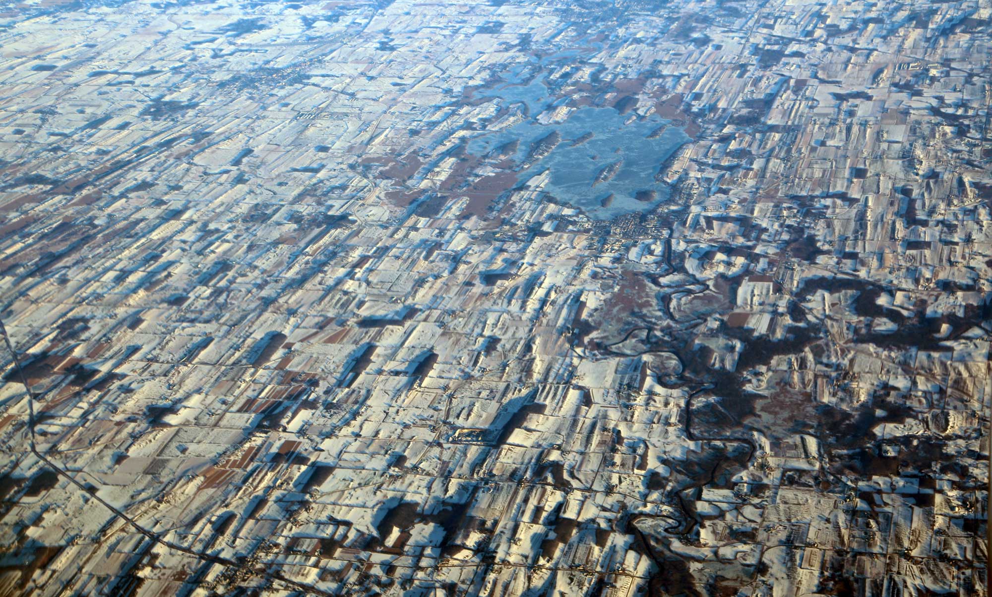
Aerial photo of drumlins near Horicon Marsh, Wisconsin, in the winter (December 2016). The drumlins, some of which appear dark because patches of forest occur on them, make the landscape look grooved. Photo by Doc Searls (flickr, Creative Commons Attribution 2.0 Generic license, image resized).
Eskers
Meltwater flowing off a glacier also leaves behind deposits. Unlike till deposits, meltwater deposits are well sorted. The faster the water is moving, the coarser the sediment deposited. Large rocks can only be moved by high-energy water, while finer sand and mud are washed downstream until enough energy is lost that they are dropped.
As a glacier melts, streams of sediment-laden meltwater often create networks of braided streams in front of the glacier. Streams of meltwater flowing under a glacier can deposit sand and gravel. When an ice sheet retreats, these snaking ridges of stream deposits, known as eskers, are left behind.
St. Olavsormen esker, Magma Geopark, Norway. The esker is the sinuous ridge. Photo Arne Østensen (Wikimedia Commons, Creative Commons Attribution-ShareAlike 3.0 Unported license, image resized).
Kettles and kames
Other glacial features include kettles and kames. Kettles are depressions left behind by the melting glacier. Blocks of ice may be broken off from the glacier and buried or surrounded by meltwater sediments. When the ice eventually melts, the overlying sediments have no support, so they frequently collapse and form a depression. That depression often fills with water to become a lake.
Kames are formed in nearly the opposite way: layers of sediment fill in depressions in the ice, leaving mound-like deposits of sorted sediment after the glacier retreats. Often, kettles and kames occur near one another.
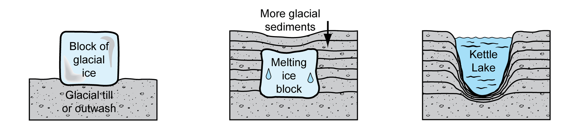
Steps in the formation of a kettle lake. Image by Jim Houghton, modified for the Earth@Home project.
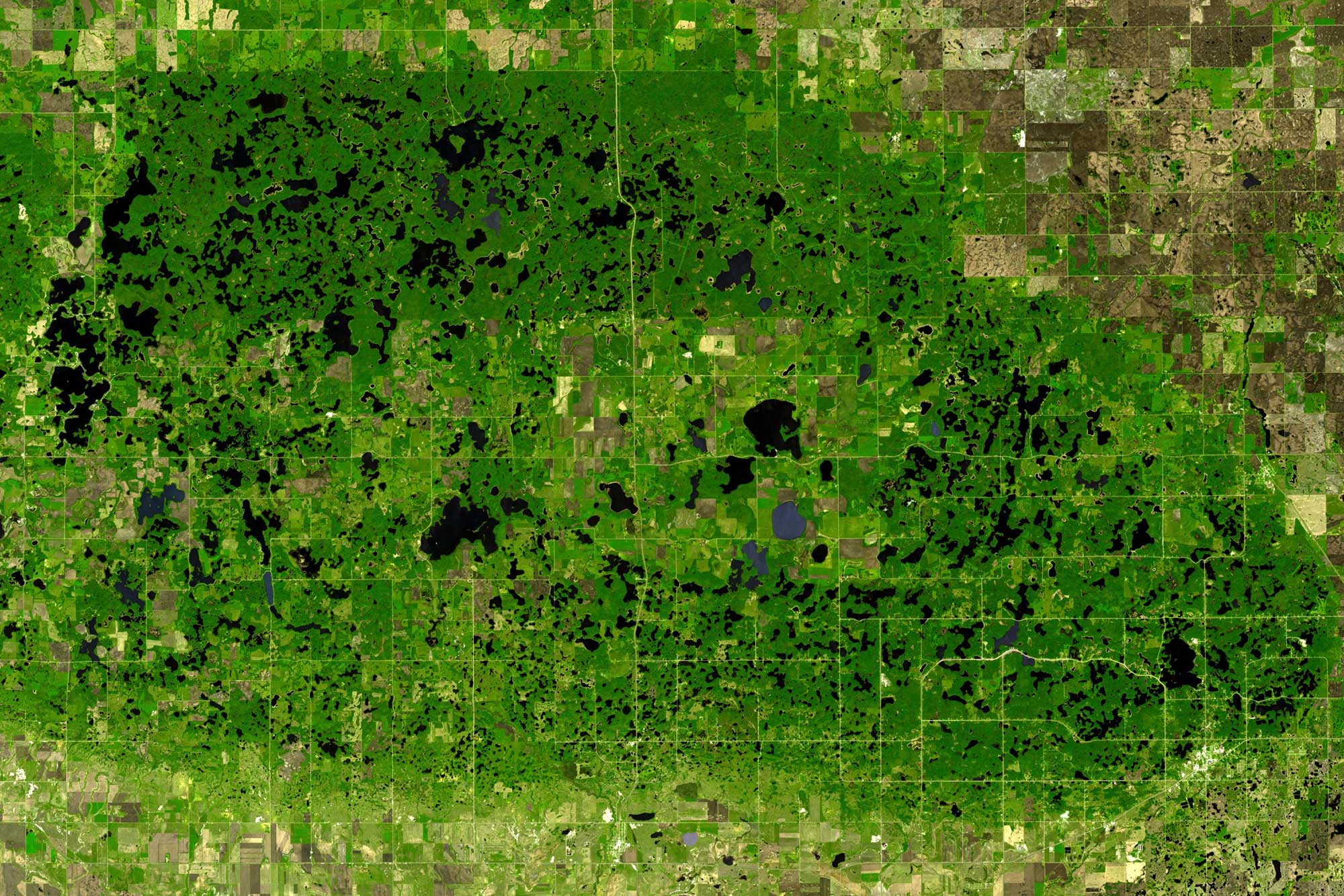
Satellite view of dead-ice moraine landscape with kettle lakes in the Turtle Mountains, northern North Dakota (U.S.A.) and southern Manitoba (Canada). Photo by NASA/GSFC/METI/ERSDAC/JAROS and U.S./Japan ASTER Science Team (NASA Earth Observatory, used following NASA's image use policy).
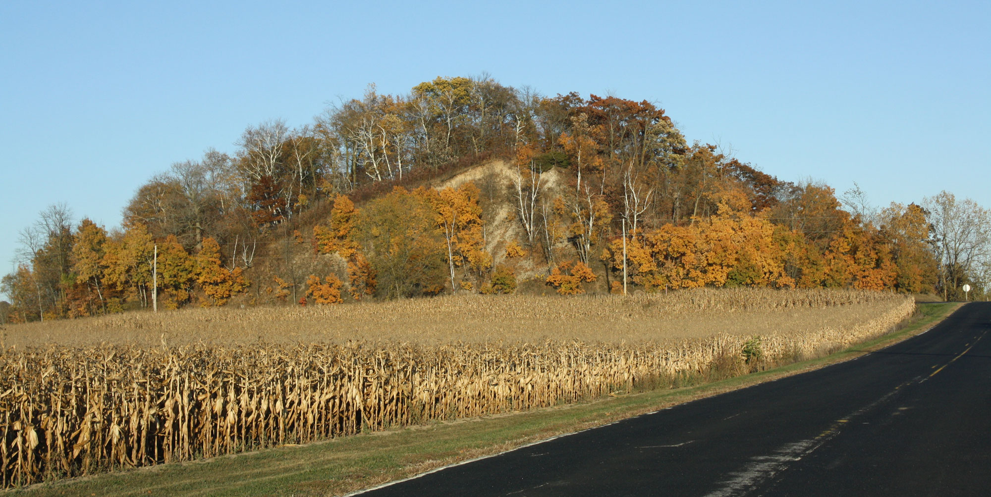
A kame (the rounded hill in the background), Kettle Moraine region, Fond du Lac County, Wisconsin. Photo by Royal Broil (flickr, Creative Commons Attribution-ShareAlike 2.0 Generic license, image cropped and resized).
Erratics
Erratics are rocks that the ice sheet picked up and transported farther south, sometimes hundreds of kilometers (miles) from their origin. They are often distinctive because they are a different type of rock than the bedrock found in the area to which they have been transported. For example, boulders and pebbles of igneous and metamorphic rocks are often found in areas where the bedrock is sedimentary. It is sometimes possible to locate the origin of an erratic if its composition and textures are highly distinctive. The pink-colored Sioux quartzite erratics found across much of northwestern Kansas are one such example; they originated in the area where Minnesota, South Dakota, and Iowa intersect.
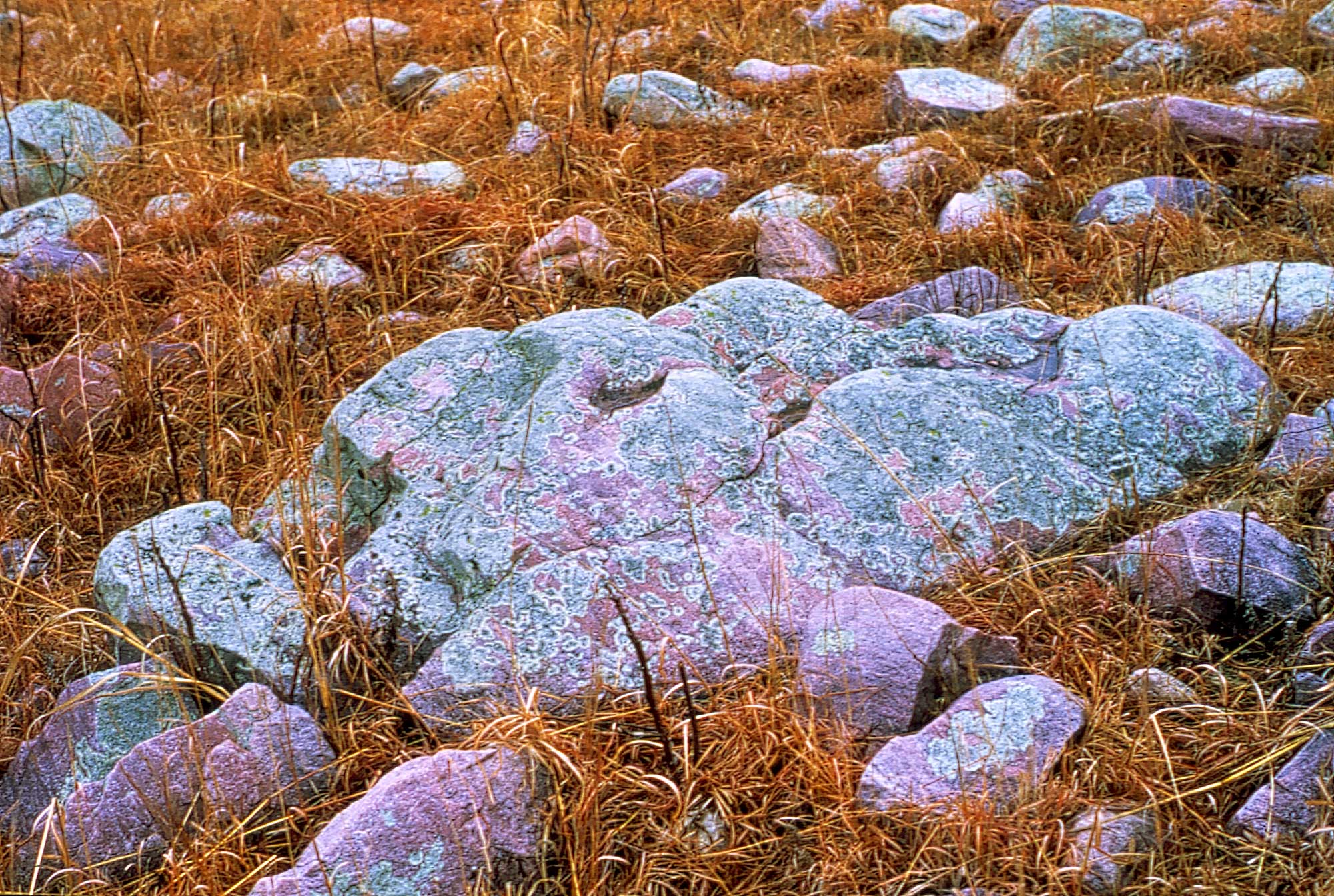
Sioux quartzite erratic boulders (boulders transported and dropped by glaciers), Wabaunsee County, Kansas. Photo by John Charlton, Kansas Geological Survey/KGS (used for non-commercial educational purposes following KGS terms of use).
Periglacial Environments
An unglaciated area near enough to a glacier to be affected by it is called a periglacial zone. The average annual air temperature in a periglacial area is between -12° and 3°C (10° and 37°F). Though the surface of the ground may melt in the summer, it refreezes in the winter. There are a variety of features associated with a periglacial zone that also provide clues to the extent of the most recent ice sheet.
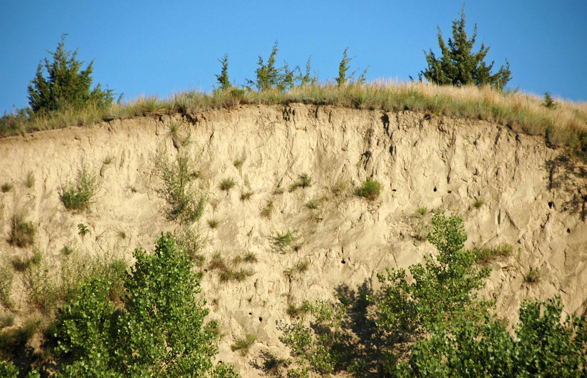
Loess
In the tundra-like environment of a periglacial zone, aeolian, or windblown deposits, are common. When these wind-blown deposits are made up of very fine sediment ("glacial flour") derived from glacial meltwater, they are called loess.
Loess Hills, Waubonsie State Park, Iowa. Loess is made up of fine-grained aeolian (wind-blown) sediment. The sediment that makes up the Loess Hills was originally transported in meltwater from Pleistocene glaciers, then blown into thick deposits by wind. The large continental glaciers that helped form the Loess Hills have long since disappeared from North America. Photo by Vincent Parsons (flickr, Creative Commons Attribution-NonCommercial 2.0 Generic license, image resized).
Exposure of Peoria Loess, which dates to the Wisconsinan glacial interval, in the Loess Canyons or Loess Plains region southeast of North Platte, Nebraska. Photo by James St. John (flickr, Creative Commons Attribution 2.0 Generic license, image resized).
Permafrost
Permafrost is a layer of soil below the surface that remains frozen all year round. Its thickness can range from tens of centimeters (inches) to a few meters (yards). Permafrost is typically defined as any soil that has remained at a temperature below the freezing point of water for at least two years.
The permafrost associated with periglacial areas, in which the ground is frozen much of the year, can cause mass movement of sediment. When the surface layer of the permafrost ground thaws, it is full of moisture. This water-heavy layer of soil may move rapidly down a hill in a process called solifluction.
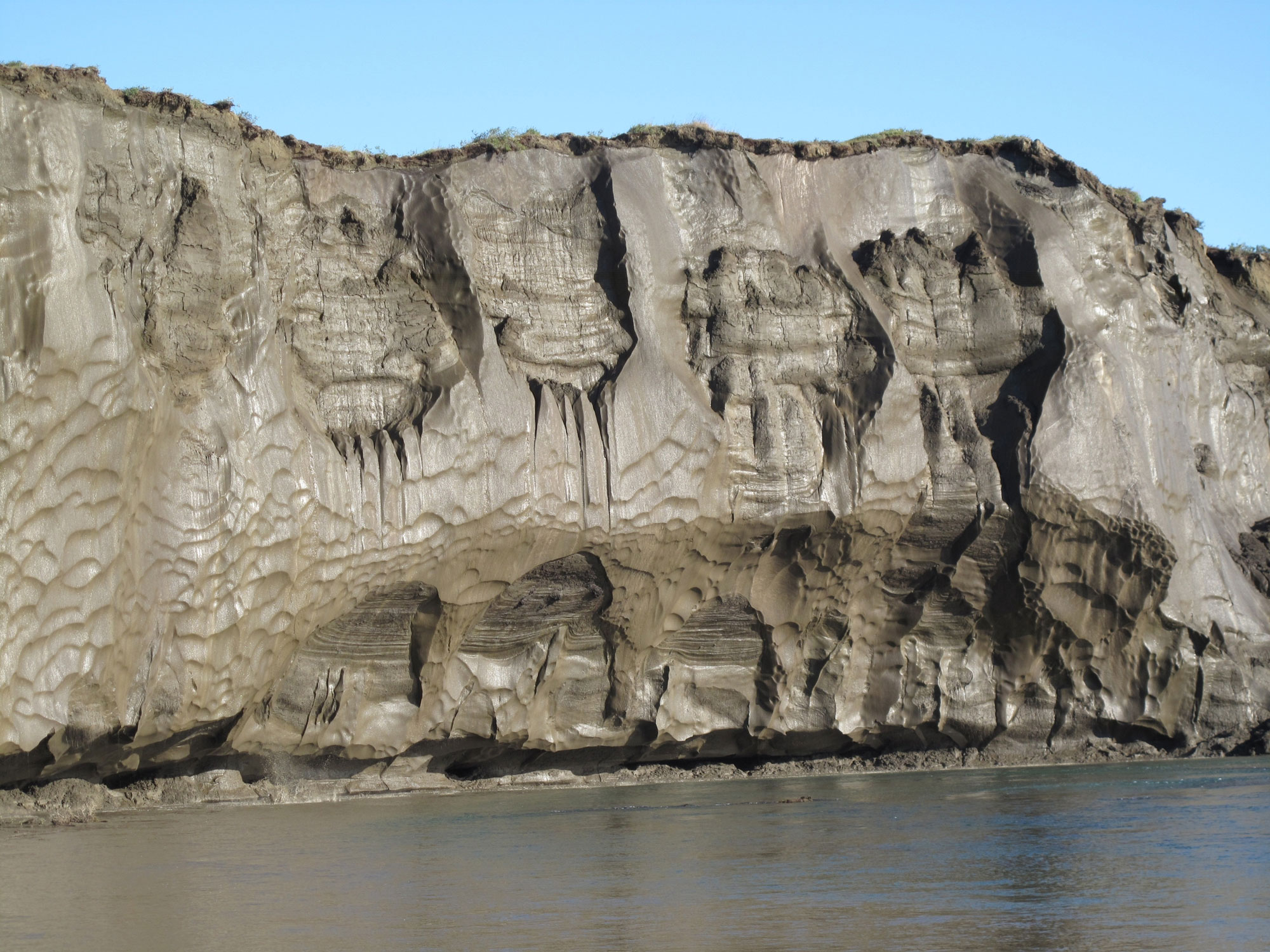
An exposed permafrost bank on the Itkillik River, northern Alaska. Photo by Mikhail Kanevskiy, University of Alaska Fairbanks, Institute of Northern Engineering (USGS, public domain).
Soil surface distorted by solifluction on the island of Svalbard, Norway. Photo by Hannes Grobe (Wikimedia Commons, Creative Commons Attribution-ShareAlike 2.5 Generic license, image resized).
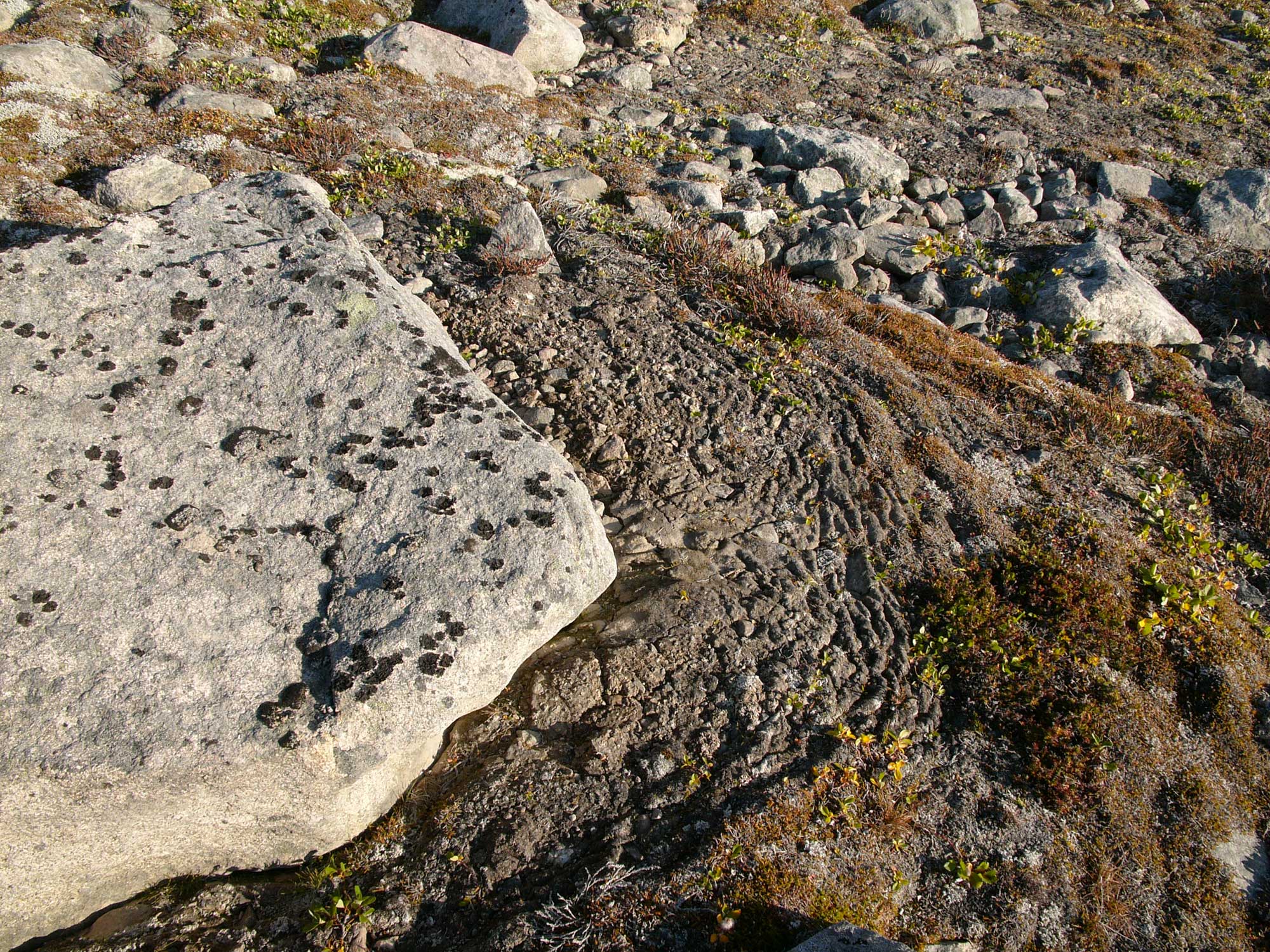
Physical weathering of the bedrock is magnified in the periglacial environment because of the freeze-thaw cycles associated with permafrost. (In fact, freeze-thaw is important in any climate that cycles above and below the freezing point of water.) When water enters the cracks and fissures in the bedrock and subsequently freezes, the ice wedges the cracks farther and farther apart. This happens because ice takes up more space than water.
As ice wedges continue to expand in joints and fractures, rocks along ridges are eventually broken off. The boulders and blocks of bedrock that have broken off due to the freeze-thaw cycle roll downhill and are deposited along the slope or as fields of talus. Frost action also brings cobbles and pebbles to the surface to form nets, circles, polygons, and garlands of rocks. These unusual patterns of sorted rock are known as patterned ground.
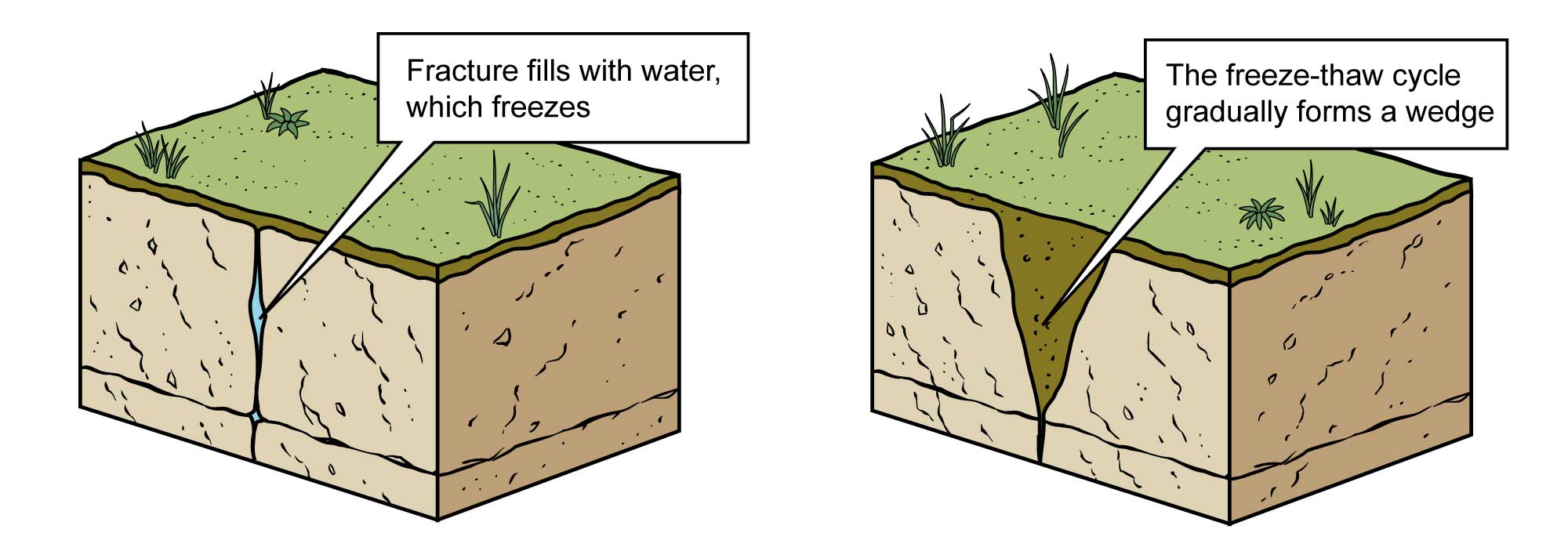
Physical weathering from a freeze-thaw cycle. Image modified from original by Jim Houghton for the Earth@Home project.
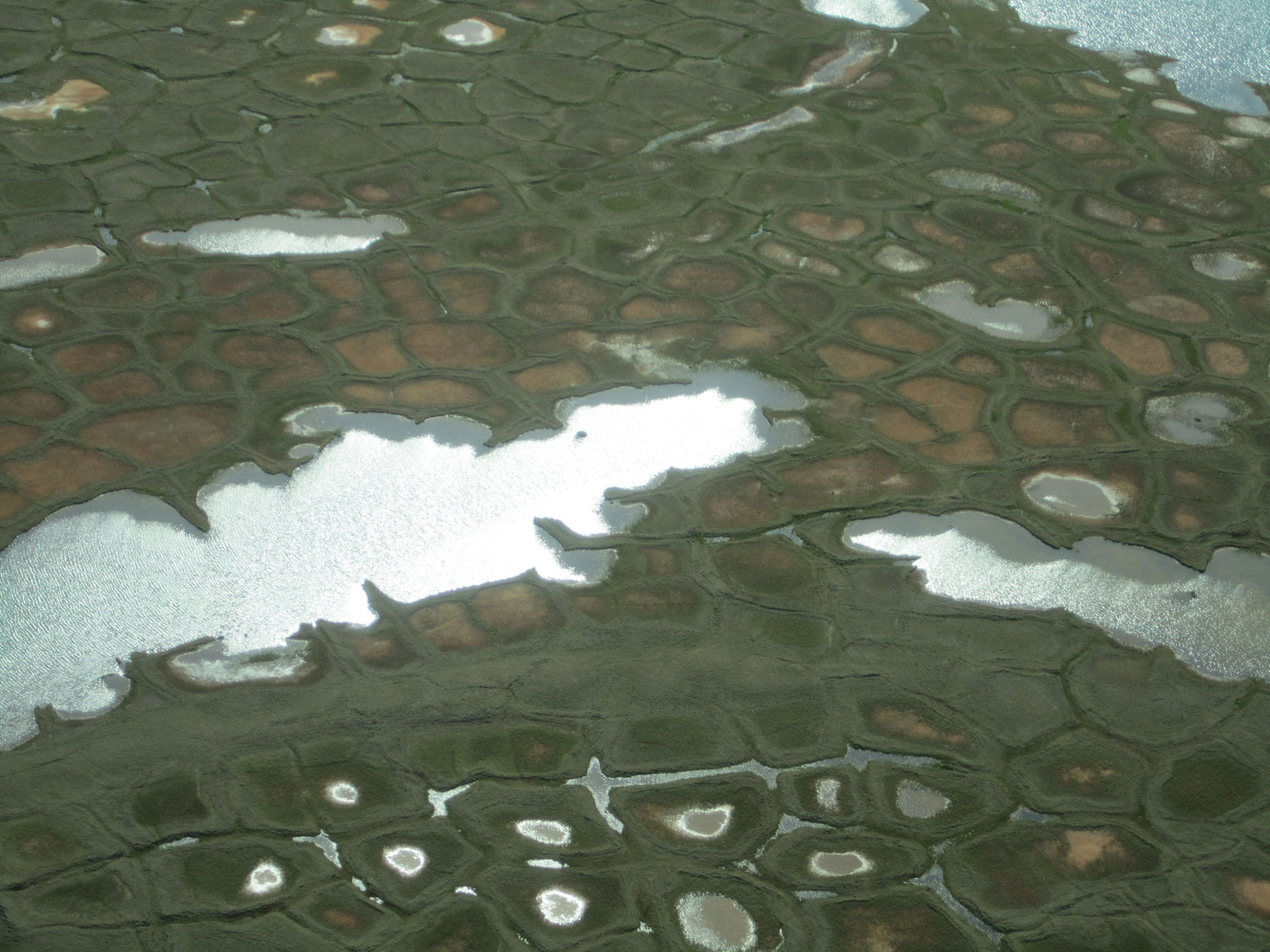
Ice wedges in the Arctic create polygonal patterned ground. In this photo, some are thawing near the surface to form ponds. Arctic Coastal Plain, Alaska. Photo by Joshua C. Koch (USGS, public domain).
The Quaternary period
For much of Earth’s history there have not been persistent ice sheets in high latitudes. Any time that the world is cool enough to allow them to form is called an “ice age.” Based on this definition, we are living in an ice age right now. The current ice age began about 34 million years ago when ice sheets were first forming on Antarctica, followed by on Greenland at least 18 million years ago. Ice sheets finally formed on North America about 2.6 million years ago, which defined the beginning of the Quaternary Period.
The Quaternary Period is divided into two epochs. The earlier Pleistocene encompasses the time from 2.6 million to 11,700 years ago, including all of the Quaternary up until the most recent episode of glacial retreat, which marks the beginning of the Holocene. During the Pleistocene, there were several dozen intervals of glaciation separated by warmer interglacial intervals characterized by glacial retreat. In North America, these cycles are known as the pre-Illinoian (1.8 million–302,000 years ago), Illinoian (191,000–131,000 years ago), Sangamonian interglacial (131,000–85,000 years ago), and Wisconsinian (85,000–11,000 years ago). The Illinoian and Wisconsinian were cooler periods that saw glaciers advance, while the Sangamonian was a warm interglacial period. The pre-Illinoian glaciation included many glacial and interglacial periods. Glaciers that extended far enough to reach Kansas and Missouri only occurred during glaciations in the pre-Illinoian period.
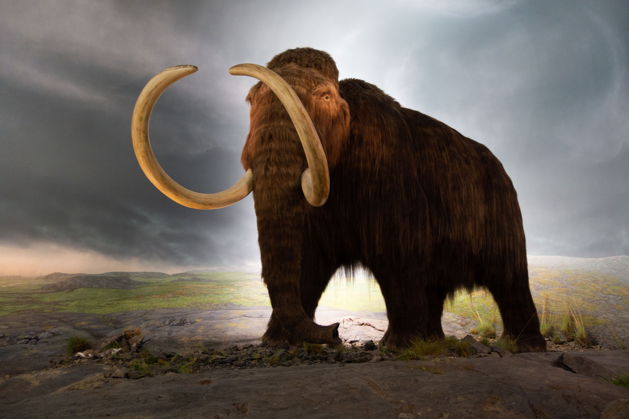
When most people use the phrase “Ice Age,” they are referring to the last glacial maximum (in other words, the last major glaciation). During this time, much of North America and Europe was covered in ice thousands of meters (feet) thick, and many kinds of large, woolly mammals roamed the unfrozen portions of those continents.
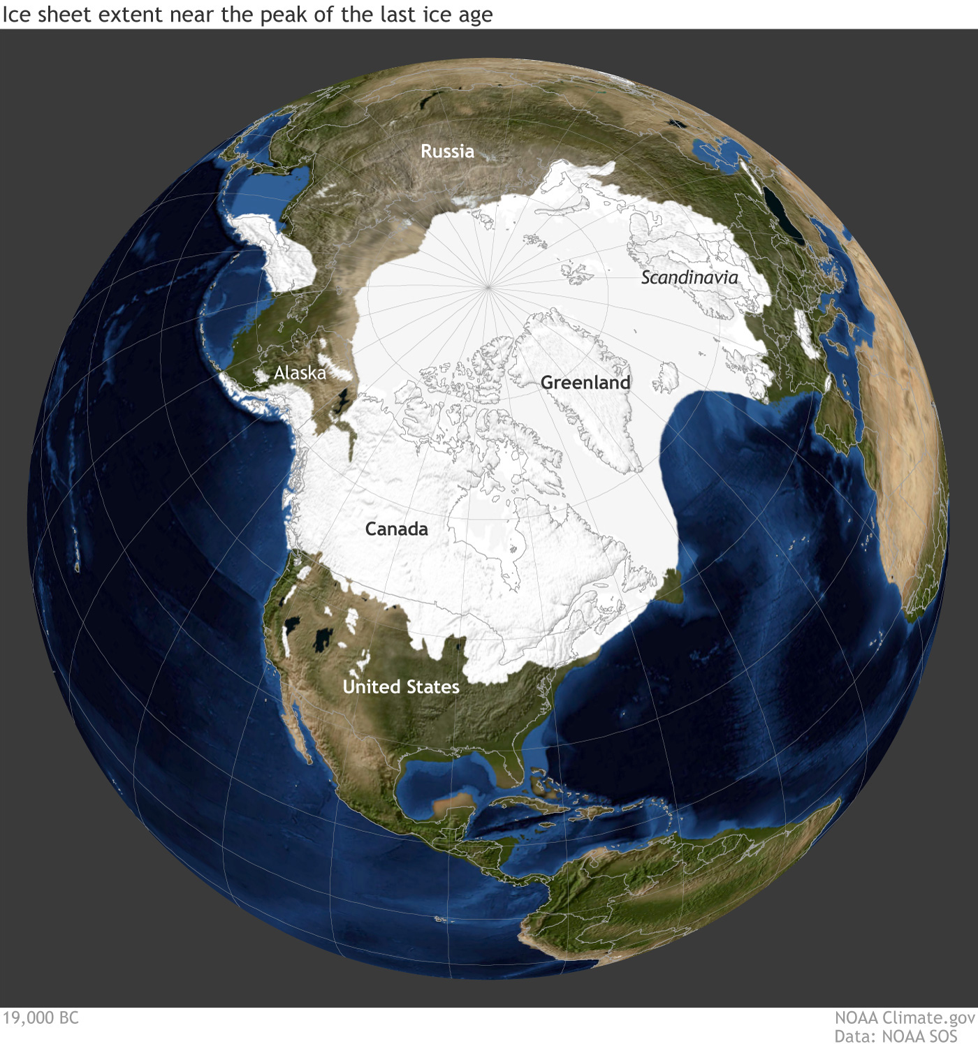
Earth during the last glacial maximum, around 20,000 years ago in the Pleistocene epoch. Much of North America was covered with a large sheet of glacial ice and the coastlines were different because sea level was lower. Reconstruction from climate.gov based on data from the University of Zurich Applied Sciences.
Model of a woolly mammoth on display at the Royal Victoria Museum, British Columbia, Canada. Photo by Thomas Quine (Wikimedia Commons, Creative Commons Attribution 2.0 Generic license, image resized).
Ice on a schedule
The enormous continental glaciers that define an ice age are so large that their extent is most directly affected by global trends. In contrast, mountain glaciers are much more susceptible to local and short-term changes in climate. Continental ice sheets advance and retreat in cycles that last tens of thousands of years and are controlled to a large extent by astronomic cycles.
Scientists continue to debate the particular causes of the onset of glaciation in North America over two million years ago. Movement of the Earth’s tectonic plates may have been a direct or indirect cause of the glaciation. As plates shifted, continents moved together and apart, changing the size and shape of the ocean basins. This, in turn, altered oceanic currents. Mountain building, which occurred when continents collided, erected obstacles to prevailing winds and changed moisture conditions. The freshly exposed rock from the rising of the Himalayas also combined with atmospheric carbon dioxide through chemical weathering; this consequent decrease in levels of atmospheric carbon dioxide was at least partially responsible for global cooling. Finally, the presence of continental landmasses over one pole and near the other was a major factor enabling the development of continental glaciers.
The cyclical movements of ice sheets seem primarily to be caused by specific astronomic cycles called Milankovitch cycles, which change the amount of light the Earth receives, particularly when comparing the summer to the winter. The cycles, predicted through principles of physics a century ago, are related to the degree of tilt of the Earth, the Earth’s distance to the sun, and the point in the Earth’s revolution around the sun during which the Northern Hemisphere experiences summer. When the cycles interact such that there is milder seasonality (cooler summers and warmer winters) at high latitudes in the Northern Hemisphere, less snow melts in summer, which allows glaciers to grow. The cyclicity of glacial-interglacial advances was about 40,000 years from before the start of the Quaternary until about a million years ago. For reasons that aren’t clear, however, the cycles changed to about 100,000 years. If not for human-induced climate change, we might expect glaciers to approach Kansas and Missouri again in about 80,000 years!
Seeking Detailed Records of Glacial-Interglacial Cycles
While glaciers have advanced over North America and retreated again dozens of times during the Quaternary, each advance scrapes away and reworks much of what was previously left behind, making it difficult to reconstruct the precise course of events. Therefore, to investigate the details of any associated climate change we must seek environments that both record climate change and are preserved in the geologic record. Since the 1970s, the international Deep Sea Drilling Project has provided a treasure trove of data on changes in the ocean that are preserved in sediments at the ocean bottom.
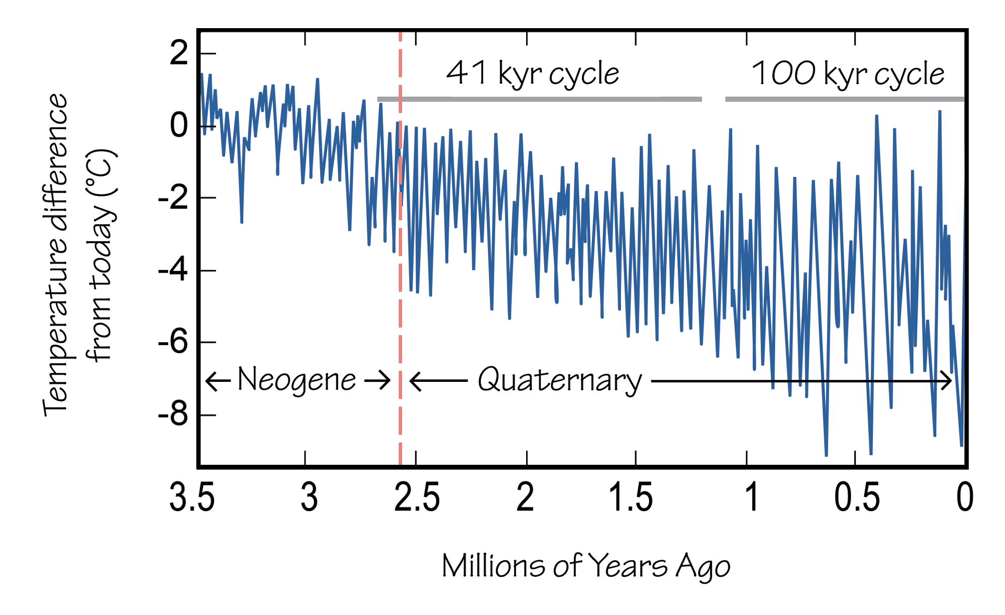
Ocean bottom temperatures from 3.6 million years ago to present, based on chemical analyses of foraminifera shells. Notice how the amplitude of glacial-interglacial variations increases through time, and how the lengths of the cycles change. Image by Wade Greenberg-Brand.
In the 1980s, coring of ice sheets in Greenland and Antarctica provided similar high-resolution data on atmospheric composition and temperature back nearly one million years.
The data from these programs have revealed that the Earth experienced dozens of warming and cooling cycles over the course of the Quaternary period. Traces of the earlier and less extensive Pleistocene glacial advances that must have occurred have been completely erased on land, so these advances were unknown before records from deep-sea cores and ice cores revealed them.
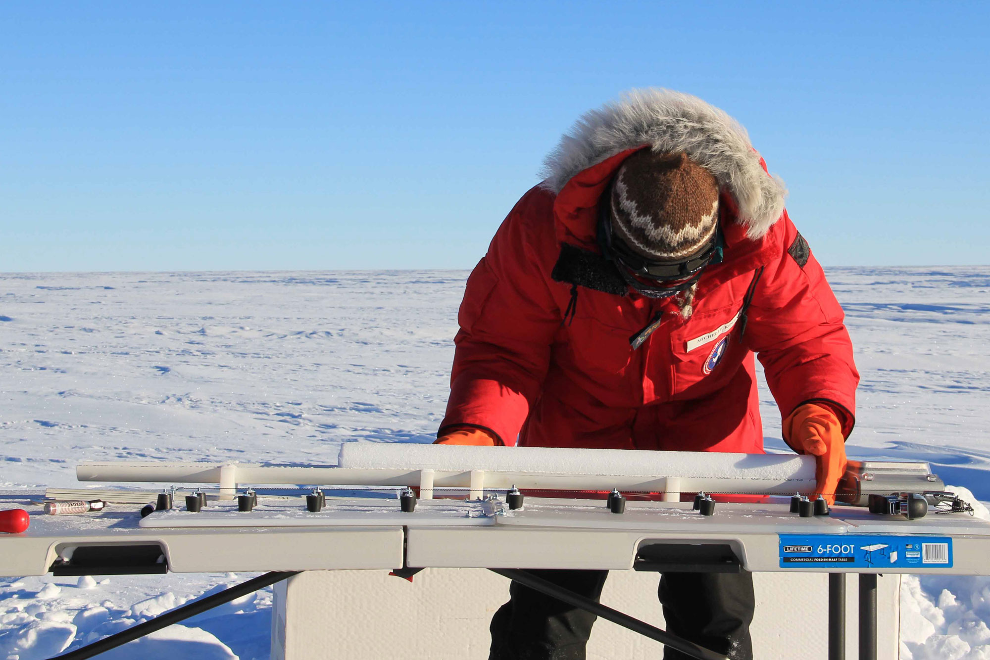
Scientist Michelle Koutnik (University of Copenhagen Center for Ice and Climate) measuring an ice core in Antarctica before it is packed for shipping. Photo by NASA/Lora Koenig (NASA Ice, flickr, Creative Commons Attribution 2.0 Generic license, image resized).