

Page snapshot: Introduction to the geologic history of the northwest-central U.S. from the Precambrian to the Quaternary Period.
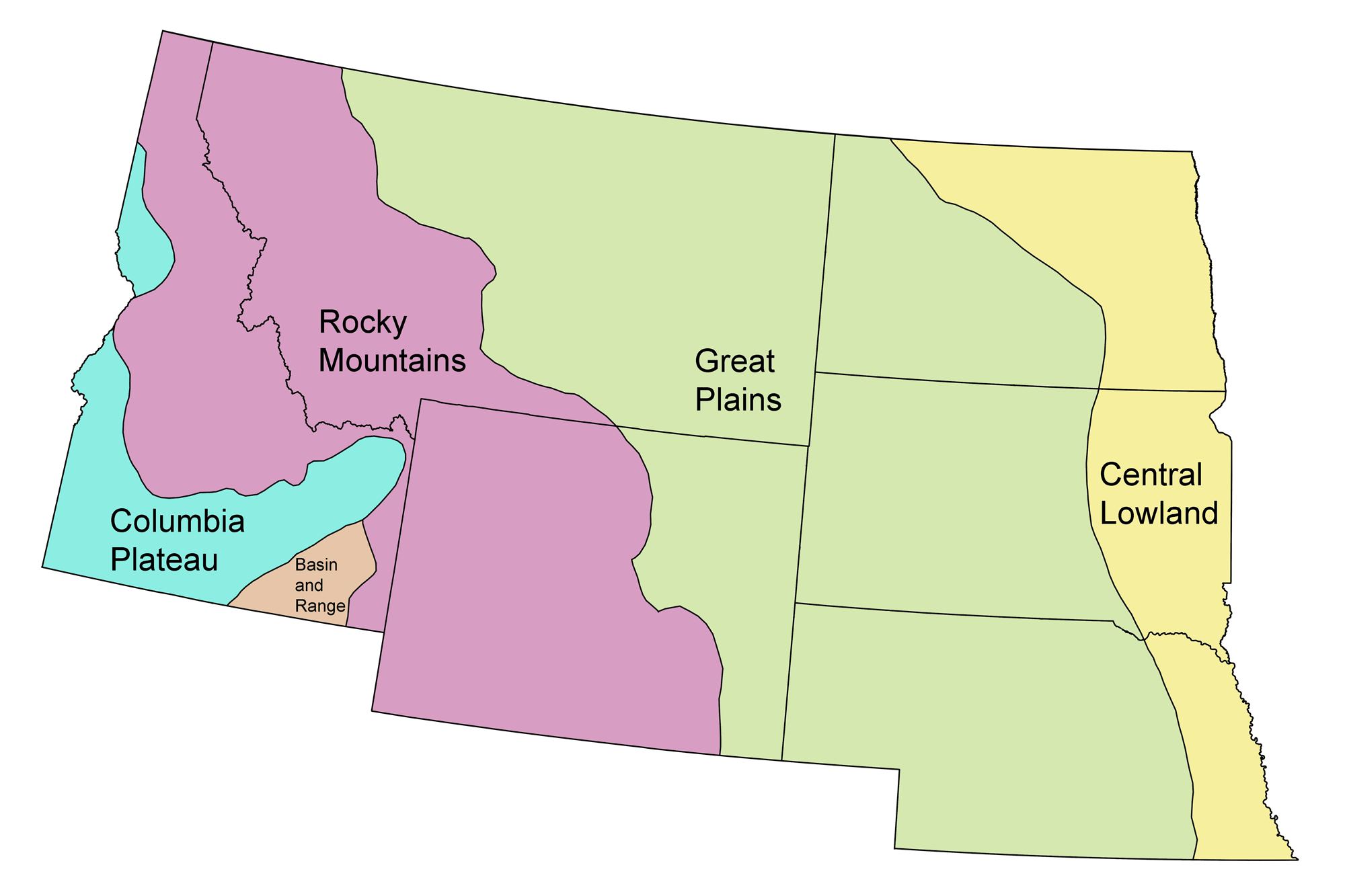
Topics covered on this page: Precambrian; Hadian to Paleoproterozoic; Mesoproterozoic to Neoproterozoic; Paleozoic; Cambrian to Devonian; Carboniferous to Permian; Mesozoic; Triassic to Jurassic; Cretaceous; Farallon Plate; Western Interior Seaway; Uplift of the Rocky Mountains; End-Cretaceous extinction; Cenozoic; Paleogene; Neogene; Yellowstone Hot Spot; Quaternary; Resources.
Credits: Most of the text of this page is derived from "Geologic history of the South Central US" by Lisa R. Fisher and Warren D. Allmon, chapter 1 in The Teacher-Friendly Guide to the Earth Science of the Northwest Central US, edited by Mark D. Lucas, Robert M. Ross, and Andrielle N. Swaby (published in 2015 by the Paleontological Research Institution; currently out of print). The book was adapted for the web by Elizabeth J. Hermsen and Jonathan R. Hendricks in 2022. Changes include formatting and revisions to the text and images. Credits for individual images are given in figure captions.
Updates: Page last updated September 8, 2022.
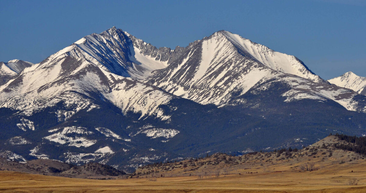
Image above: Loco Mountain, Montana. Photo by Mike Cline (Wikimedia Commons, Creative Commons Attribution-ShareAlike 4.0 International license, image cropped and resized).
Precambrian (4.6 billion to 541 million years ago)
Hadean to Paleoproterozoic (4.6 to 1.6 billion years ago)
The Earth is estimated to be approximately 4.6 billion years old, an age obtained by dating meteorites. Rocks dating to around four billion years old are found on almost every continent, but the oldest rocks known on Earth are 4.3 billion-year-old rocks found along the eastern shore of Hudson Bay in northern Quebec. These are part of the Canadian Shield, the ancient core of the North American continental landmass, which has experienced very little tectonic activity (faulting and folding) for millions of years. Shields, or cratons, are the stable cores of all continents and are often covered by layers of younger sediments. They formed and grew during pulses of magmatic activity, as bodies of molten rock deep in the Earth’s crust contributed to form new crust.
In the northwest-central U.S., the main cratonic elements are referred to as the Wyoming Province (Wyoming and eastern Montana), the Medicine Hat Block (northwestern Montana), and the Superior Province (Dakotas, Minnesota, Wisconsin, and Michigan). Outcrops of these rocks are exposed mainly as uplifted blocks in mountain ranges throughout Wyoming, Montana, and South Dakota. The oldest rocks identified so far in the northwest-central U.S. are 3.6- to 3.8-billion-year-old granitic gneisses found in Wyoming’s Wind River Mountains.
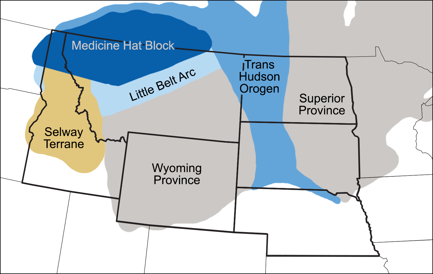
Cratonic elements and belts of deformation in the northwest-central region. Modified from a map by Wade Greenberg-Brand, originally published in The Teacher-Friendly Guide to the Earth Science of the Northwest Central US.
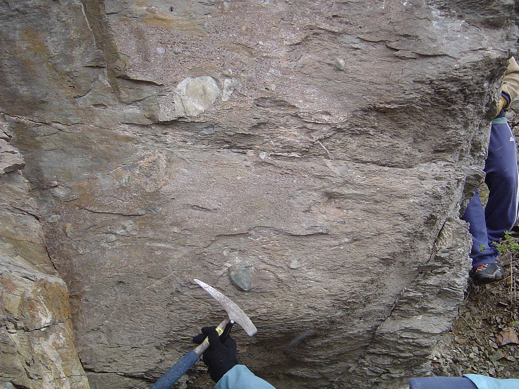
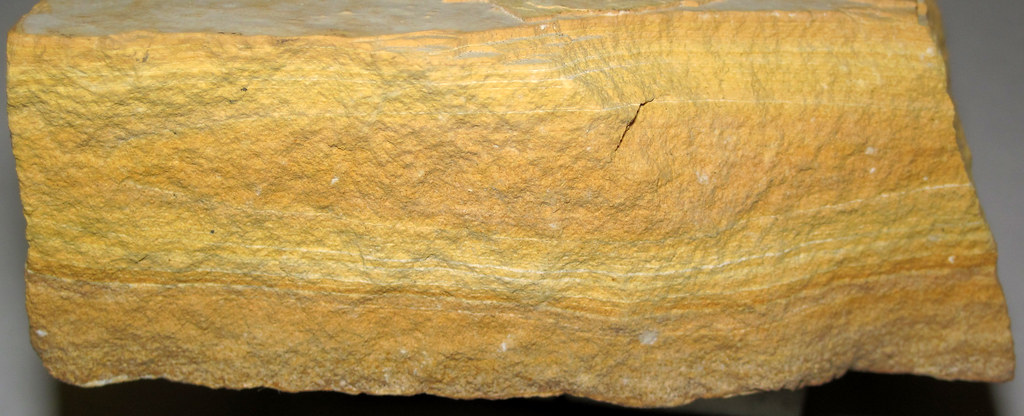
It is very difficult to reconstruct the size, shape, and position of continents during the Precambrian. Fewer rocks are preserved from this time, and those that remain have been highly altered. Nevertheless, sediment eroded from Laurentia (the proto-North American continent) and deposited in the ocean waters on the edge of the continent can be found today 2.0- to 2.5-billion-year-old Snowy Pass Supergroup in southern Wyoming’s Snowy Range. Here, thick sequences of sandstone, conglomerate, and limestone were deposited near what is now the southern margin of Wyoming. These sediments contain 2.3-billion-year-old stromatolites (mounds of sediment formed by mats of photosynthetic cyanobacteria), indicating that they were deposited in a continental shelf environment. During this time period, at least two episodes of glaciation occurred, represented by rocks formed from glacially derived sediments (tillites) found in Idaho and Montana.
Around two billion years ago, zones of collision between Laurentia and other landmasses (cratons or continental fragments) are preserved as deformed metamorphic rocks in the Little Belt Arc of northern Idaho and Montana, the Selway Terrane of southern Idaho, and the Trans-Hudson Orogen of the Dakotas and Canada.
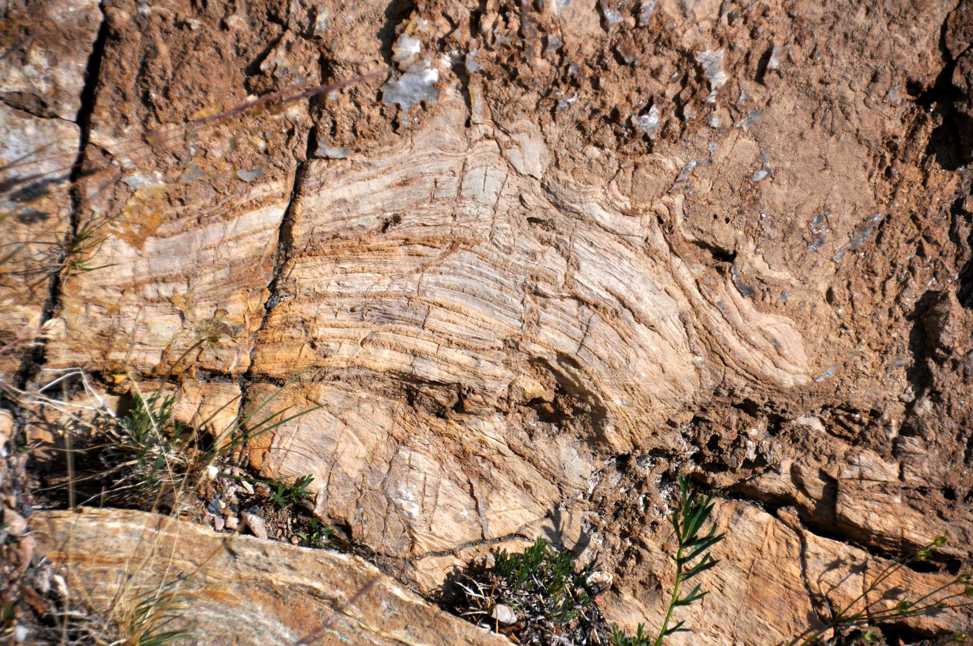
Close-up view of stromatolites in the Precambrian (Paleoproterozoic, 2.08 to 2.06 billion-year-old) Nash Fork Formation, Snowy Pass Supergroup, Wyoming. Photograph by James St. John (flickr, Creative Commons Attribution 2.0 Generic license; image rotated and resized).
Tillite (diamictite), Pocatello Formation, Idaho. Photog by Qfl247 (Wikimedia Commons, Creative Commons Attribution-ShareAlike 3.0 Unported license).
Mesoproterozoic to Neoproterozoic (1.6 billion to 541 million years ago)
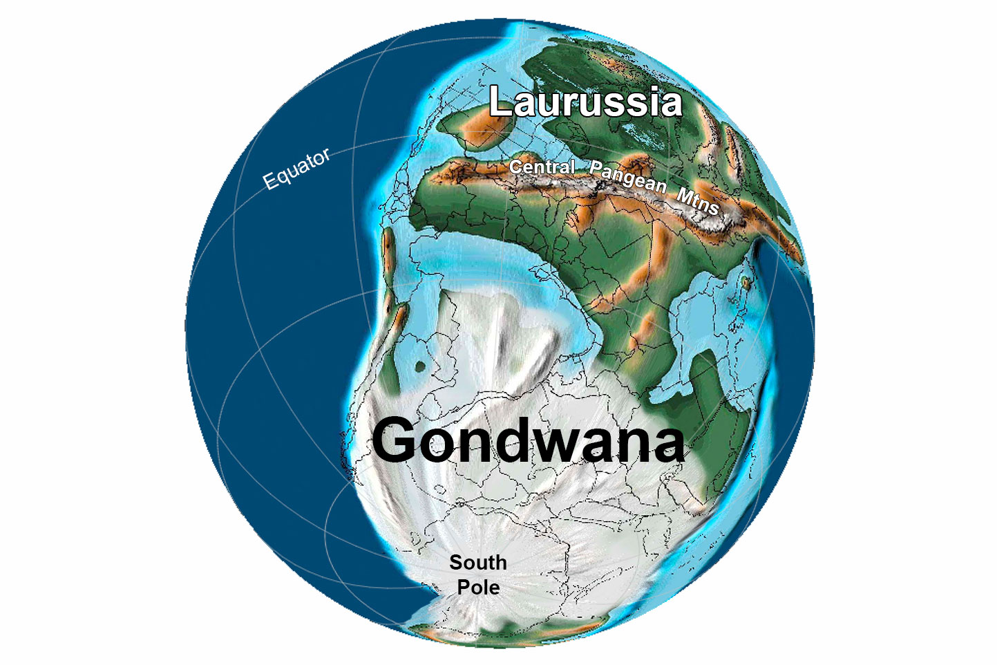
The remainder of the Precambrian period saw the formation of a the supercontinent Rodinia about 1.4 billion and 900 million years ago, followed by its eventual breakup about 750 million years ago. Preserved remnants of the continental collisions that formed this supercontinent are found widely across modern North America, but very few of these elements are recognizable in the northwest-central U.S.
The breakup of Rodinia was associated with the formation of rifts throughout North America, with igneous activity occurring in rifted zones and continuing slowly and irregularly until about 600 million years ago. North America’s rifted edges formed passive margins, where sediments were deposited on continental shelves into the early Paleozoic era.
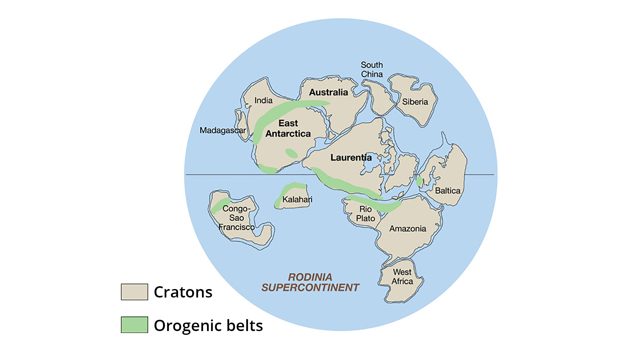
The supercontinent Rodinia, around 1.1 billion years ago. Laurentia represents proto-North America. Image adapted from original created by John Goodge for the United States Geological Survey (public domain).
Paleozoic (541 to 252 million years ago)
Cambrian to Devonian (541 to 359 million years ago)
During the Cambrian, the area that is now the states of California, Oregon, Washington, Idaho, and Nevada did not yet exist as part of the North American continent. The edge of North America’s continental shelf was located at approximately the Arizona-Utah-Nevada-Idaho line.
Trilobites from Cambrian rocks of Yellowstone National Park. Left: Pieces of Wilbernia walcotti, Cambrian Snowy Range Formation. Right: Pygidium of Ehmania walcotti. Left photo of USNM 35227 and right photo of USNM 90667 by Megan Norr (Yellowstone National Park on flickr, public domain).
In the late Devonian (370 million years ago), a portion of the continental shelf adjacent to present-day Idaho and Nevada transitioned from quiet passive margin to an active subduction zone, where oceanic crust plunged beneath the continent. Here, as oceanic crust descended deep into the upper mantle, the rock above the descending crust melted to form a line of volcanoes on the surface. Subduction also led to accretion. Sediment, sedimentary rock, and even bits of the oceanic crust itself were scraped off the descending crustal plate and pushed onto the overlying plate. Just as a rug develops folds when pushed from the side, these rocks were wrinkled up into mountains. Volcanic islands carried along by the subducting plate also accreted to the edge of the continent. The landmass began to rotate, moving the North American plate into a more modern orientation.
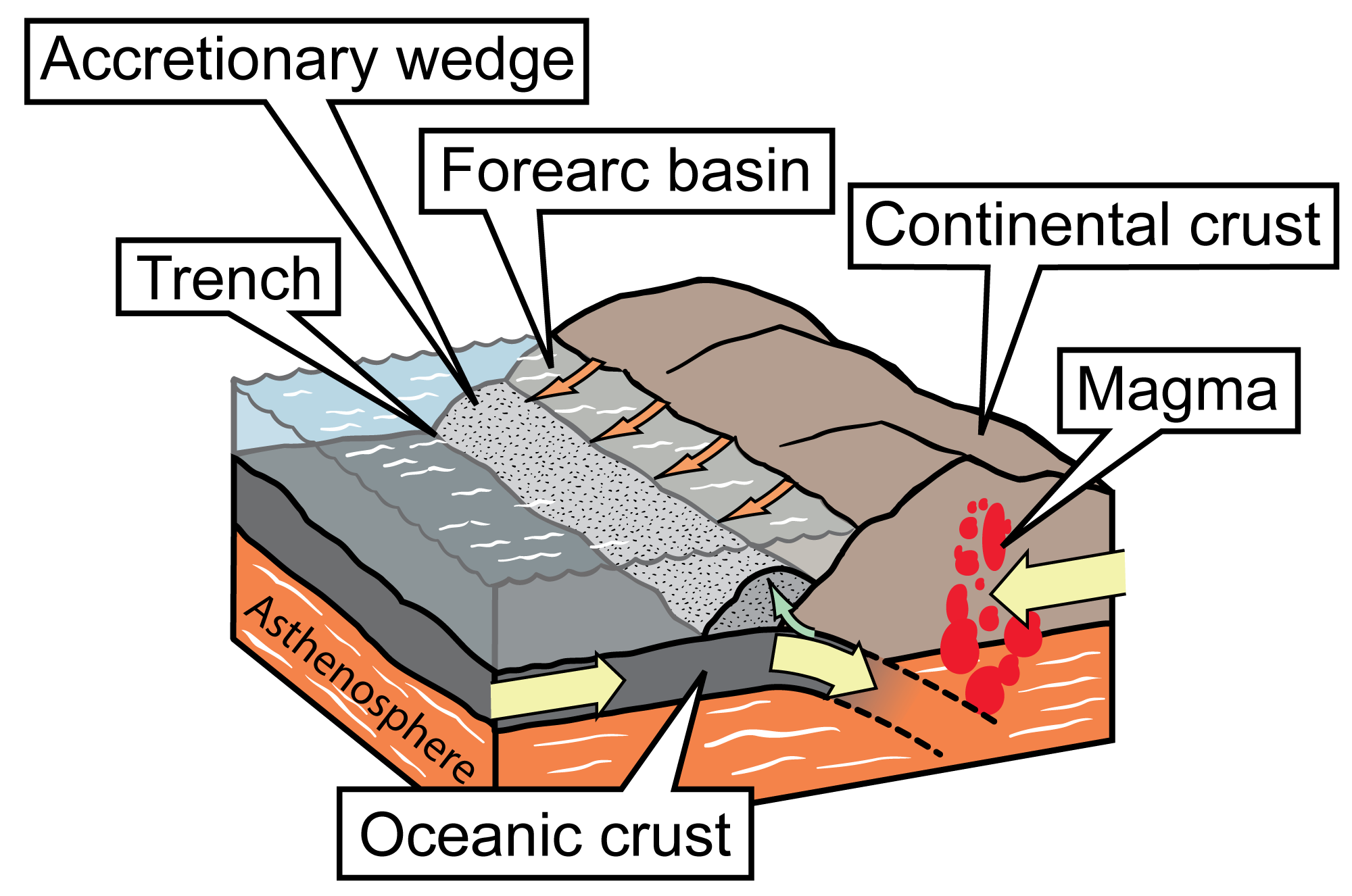
Simplified diagram of a convergent boundary at which continental crust and oceanic crust are colliding. The denser oceanic crust is subducted, or forced under, the more buoyant continental crust. The oceanic crust melts as it is subducted, and an accretionary wedge forms where the oceanic plate is scraped against the continental crust; in front of the wedge is a trench. Subduction of the oceanic crust produces magma, which wells up, causing volcanic activity. Image modified for Earth@Home from original by Jim Houghton, first published in The Teacher-Friendly Guide series (CC BY-NC-SA 4.0 license).
Carboniferous to Permian (359 to 252 million years ago)
During the Carboniferous, plate tectonics led to the initial stages of Pangaea’s assembly. As North America began to collide with Gondwana, forces from the collision began to affect the continent’s topography.
During the Mississippian (340 million years ago), most of the West Coast had transformed into a subduction zone. A series of exotic terranes, consisting of sedimentary rock made from former seafloor sediment, slabs of volcanic and granitic rock, and the remains of volcanic islands, collided with and accreted to western North America. These collisions deformed and elevated the continent’s topography, generating two major mountain-building events: the Antler Orogeny (340 million years ago) and the Sonoman Orogeny (245 million years ago).
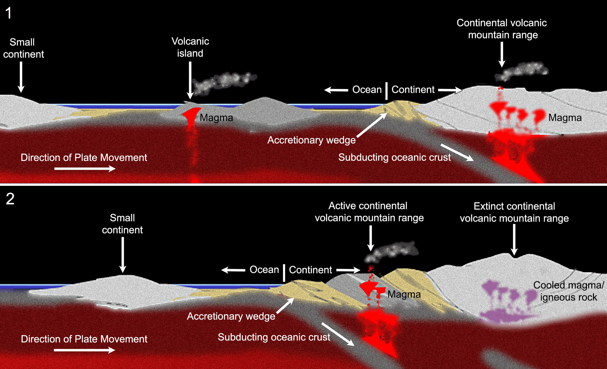
Idealized diagram showing the docking and accretion of a volcanic island at the edge of a continent. Upper diagram (1): A volcanic island (center) on oceanic crust moves toward the edge of a large continent (right). As the oceanic crust is subducted, an accretionary wedge forms at the edge of the continent and the melting oceanic crust in the subduction zone produces magma, which rises through the continental crust and forms a volcanic mountain range. Lower diagram (2): The volcanic island has docked on the edge of the continent. The active subduction zone has moved seaward, meaning that the original continental volcanic mountain range has gone extinct and an active continental volcanic mountain range has formed near the new subduction zone. The old accretionary wedge is sandwich between the extinct volcanic mountain range and the new active continental volcanic mountain range. A new accretionary wedge has formed at the active subduction zone. Image modified for Earth@Home from original by Frank Granshaw, first published in The Teacher-Friendly Guide to the Earth Science of the Western US (CC BY-NC-SA 4.0 license).
During the Pennsylvanian (300 million years ago), compressional forces from the collision and tension from coastal subduction combined to deform the continent’s interior, buckling the crust and creating deep basins between uplifted blocks. Shallow inland seas spread across the interior of the continent, covering parts of North America’s Precambrian shield. Uplift formed a mountain range, known as the Ancestral Rocky Mountains, in Wyoming, Colorado, and New Mexico, and land was also raised above sea level in Canada, Montana, and the Dakotas. Sediments that eroded from this range and other uplifted areas were transported to the inland sea and the continental margins, forming deposits of conglomerates, sandstones, shales, limestones, and evaporite minerals.
Although the Ancestral Rocky Mountains have long since eroded away, remnants of their core remain and can be seen today in Colorado and Utah. As accretion continued over time, the coastline moved farther seaward. Sea level fell in the late Paleozoic, during the Pennsylvanian and Permian, as continental collisions progressed to form the supercontinent Pangaea.
Earth 300 million years ago, during the end of the Carboniferous Period (Pennsylvanian). Reconstruction created using basemap from the PALEOMAP PaleoAtlas for GPlates and the PaleoData Plotter Program, PALEOMAP Project by C. R. Scotese (2016); map annotations by Jonathan R. Hendricks & Elizabeth J. Hermsen for PRI's Earth@Home project (CC BY-NC-SA 4.0 license).
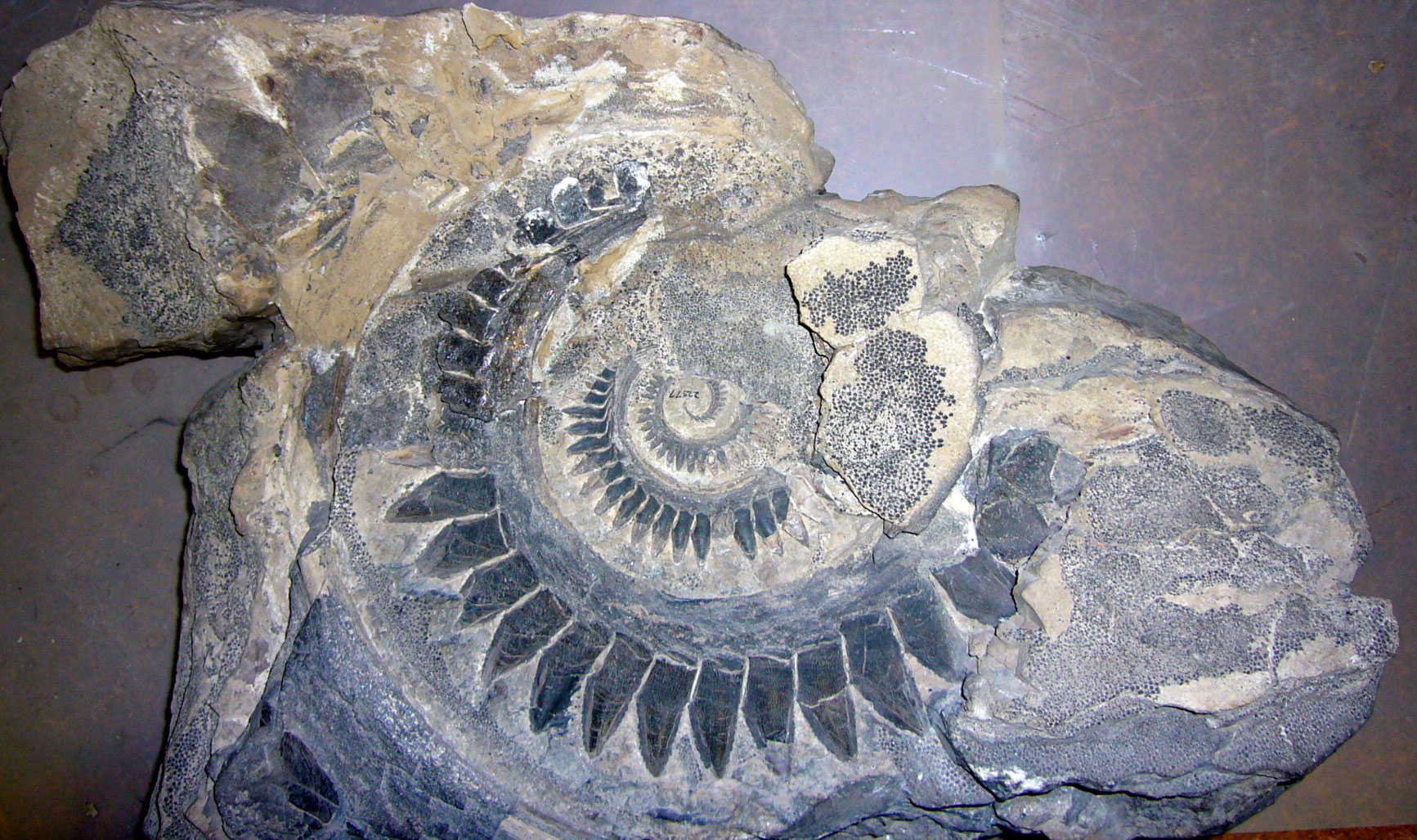
Tooth whorl of a shark (Helicoprion), Permian Phosphoria Formation, Conda Mine, Idaho. Photo of USNM V 22577 by Michael Brett-Surman (Smithsonian National Museum of Natural History, public domain).
Mesozoic (252 to 66 million years ago)
Triassic to Jurassic (252 to 145 million years ago)
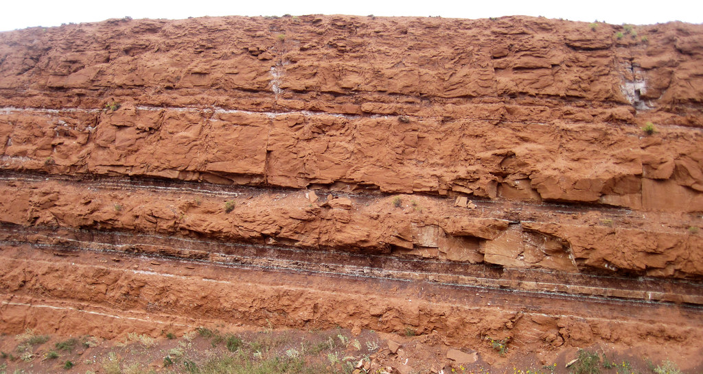
The supercontinent Pangaea was in place by the end of the Permian period, and global sea level was probably at its lowest of any time during the past 600 million years. During the Triassic and Jurassic, sea levels rose, and a shallow arm of the sea reached from Canada through Montana and parts of Wyoming. Iron-rich limestones, sandstones, and mudstones laid down in this sea were oxidized, giving a distinctive and characteristic red color to the rocks, which are appropriately called “red beds.”
During the Jurassic, mudstone and sandstones were also deposited in lowland areas and river channels throughout the Rocky Mountains and Colorado Plateau; these formed the Morrison Formation, which is famous for its abundant dinosaur fossils.
An outcrop of Triassic sandstone (Chugwater Formation) near Thermopolis, Wyoming. Photograph by James St. John (Flickr; Creative Commons Attribution 2.0 Generic license).
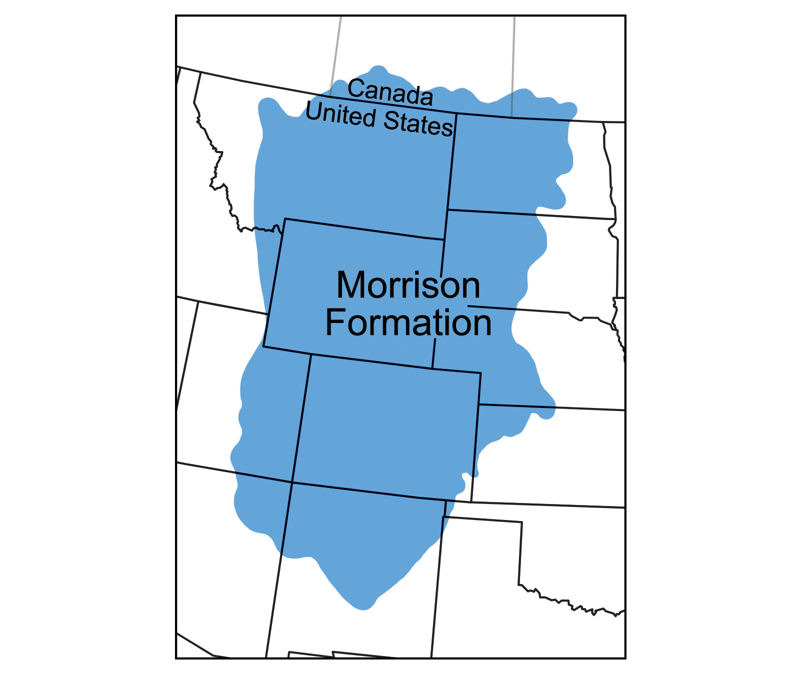
Geographic extent of the Jurassic Morrison Formation. Map modified from a map by Wade Greenberg-Brand, originally published in The Teacher-Friendly Guide to the Earth Science of the Southwestern US.
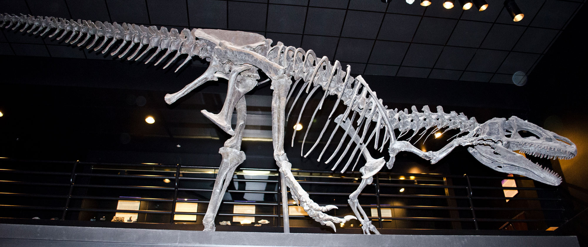
"Big Al" (Allosaurus fragilis), Jurassic Morrison Formation, Big Horn County, Wyoming. Specimen on display at the Museum of the Rockies, Bozeman, Montana. Photo by Tim Evanson (flickr, Creative Commons Attribution-ShareAlike 2.0 Generic license, image cropped and resized).
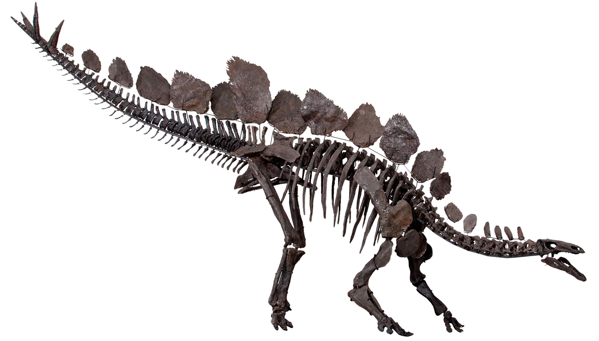
"Sophie" (Stegosaurus stenops), Jurassic Morrison Formation, Big Horn County, Wyoming. Specimen on display at the Natural History Museum, London. Source: From Fig. 1 in Maidment et al. (2015) PLoS ONE 10(10): e0138352 (Creative Commons Attribution 4.0 International license, image copyright The Natural History Museum).
Cretaceous (145 to 66 million years ago)
The Farallon Plate
When the supercontinent of Pangaea came together in the late Paleozoic Era, most of the world's continents were combined into the single landmass of Pangaea. Because of this, most of the world's seawater was found in a single ocean called the Panthalassic Ocean. The Panthalassic Ocean was essentially the ancient Pacific Ocean.
By the early Jurassic period, much of the floor of the Panthalassic Ocean was made up of three large plates: the Izanagi plate in the northwest, the Farallon Plate in the northeast, and the Phoenix Plate in the south. The modern Pacific Plate first formed by seafloor spreading at the junction between these plates about 190 million years ago. Over time, the Pacific Plate continued to grow by seafloor spreading. Meanwhile, the Farallon Plate shrank in area as it was subducted beneath the western margin of Pangaea (the western margin of the present-day Americas).
The subduction of the Farallon plate played an important role in building mountains in North America during the Mesozoic and Cenozoic eras. Today, remnants of the Farallon Plate include the Juan de Fuca, Cocos, and Nazca plates that exist along the western margin of the Americas.
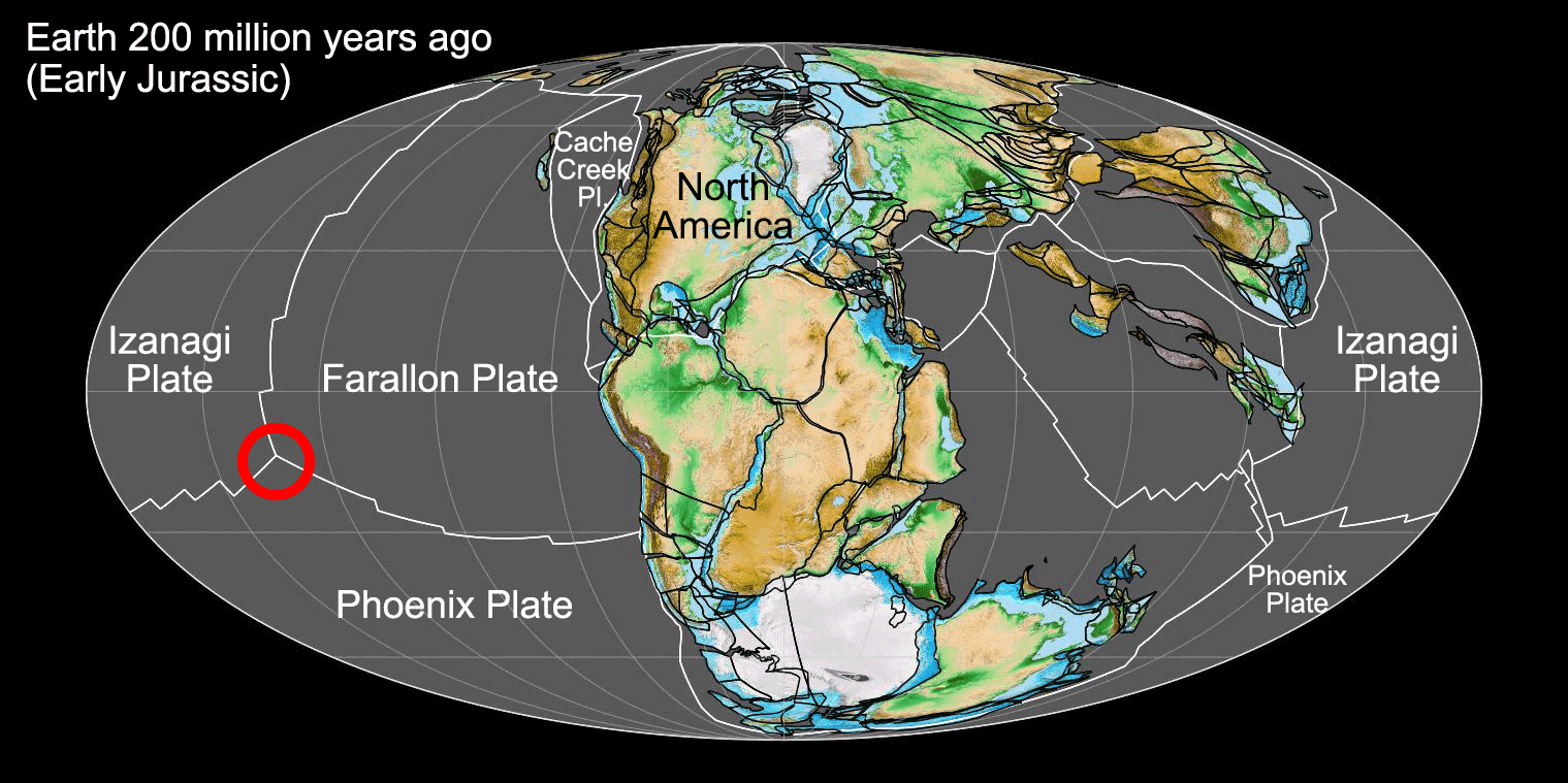
Earth 200 million years ago, showing Pangaea and the ancient Panthalassic Ocean (or the ancient Pacific). At this time, Earth's continents were combined into the supercontinent Pangaea. The floor of Panthalassa was largely made up of three plates, with the Farallon Plate bordering the western coast of ancient North America. The Pacific Plate, which makes up much of the floor of the modern Pacific ocean, originated at the junction between the Farallon, Izanagi, and Phoenix plates during the Jurassic Period (shown by the red circle on the map). Map by Fama Clamosa (Wikimedia Commons, Creative Commons Atribution-ShareAlike 4.0 International license, image cropped and labelled).
The Western Interior Seaway
During the Early Cretaceous, Pangaea entered its final stages of breakup. Far to the west, oceanic crust (the Farallon plate) had been subducting under western North America for tens of millions of years, causing a series of volcanic island complexes to collide with and become accreted to that margin of the continent, forming the Sierra Nevada of California. As the new Atlantic Ocean widened, sea levels began to rise.
Around 85 million years ago, when the Farallon plate began to subduct at an unusually shallow angle, it slid farther inland beneath western North America before finally sinking into the asthenosphere. This downwarped the center of the continent and created a basin that allowed the waters of the Gulf of Mexico to meet with those in the north, forming the Western Interior Seaway, which inundated a 1000-kilometer (620-mile) wide swath from Mexico to Alaska. During the very latest stages of the Cretaceous period, around 70 million years ago, the Western Interior Seaway was displaced by slow uplift of the continent.
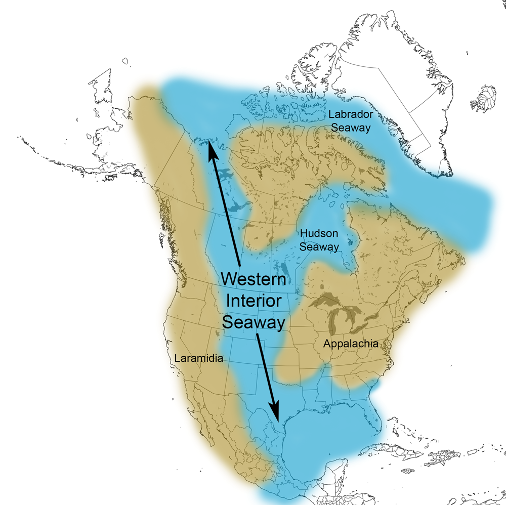
Extent of the Western Interior Seaway during the Cretaceous Period. Image from Cretaceous Atlas of Ancient Life: Western Interior Seaway (Creative Commons Attribution-NonCommercial-ShareAlike 4.0 International license).
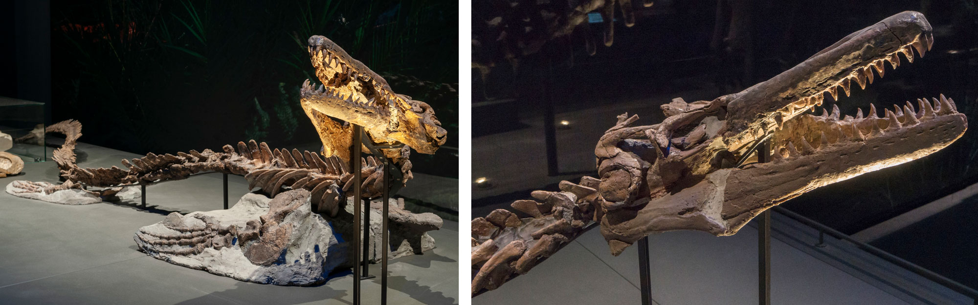
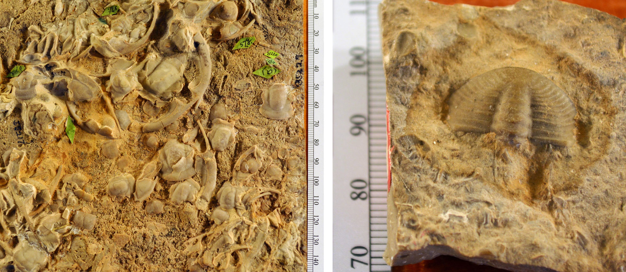
A mosasaur (Platycarpus ictericus) from the Cretaceous of South Dakota. Left: Full specimen. Right: Detail of skull. Specimen on display in the Naturalis Biodiversity Center, Leiden, The Netherlands. Photos of RGM.401860 by Naturalis Biodiversity Center (on GBIF, CC0 1.0 Universal/public domain dedication).
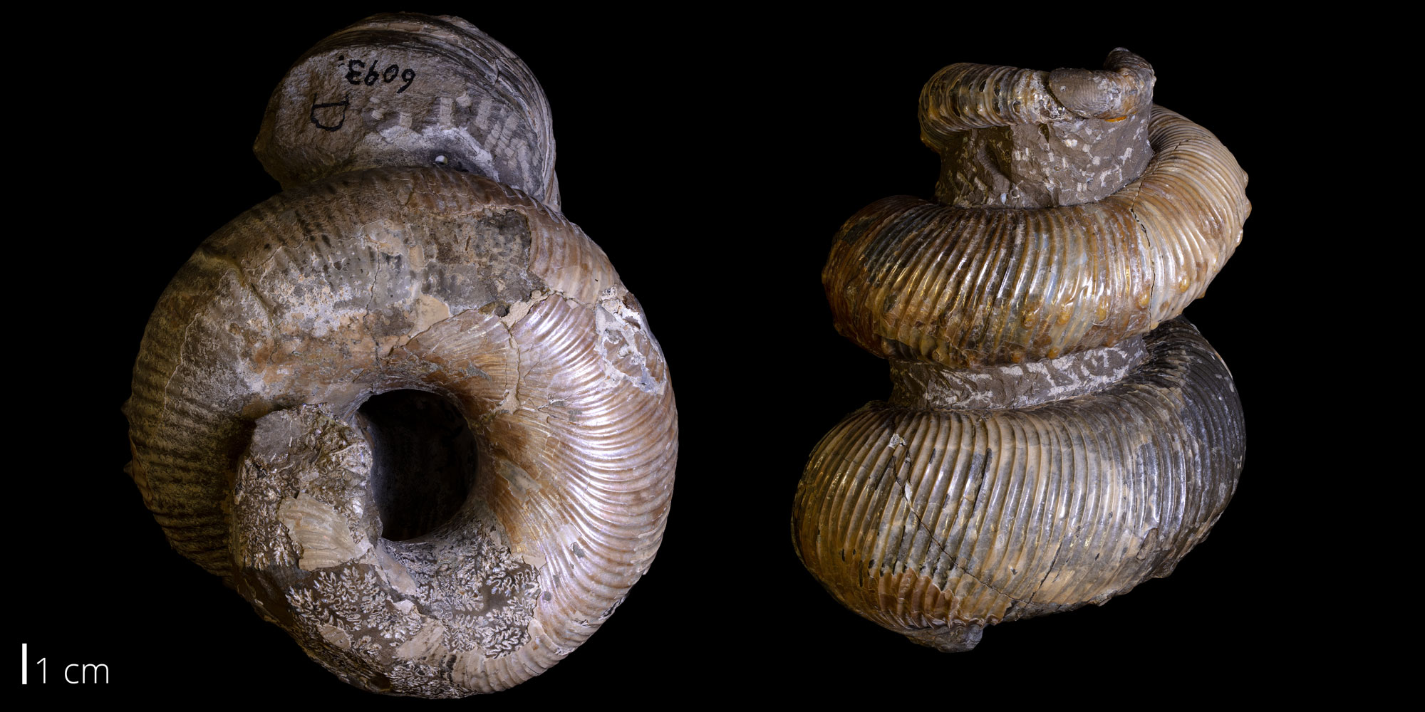
A heteromorph ammonoid (Emperoceras beecheri), Late Cretaceous Pierre Shale, Custer County, South Dakota. Photo of Yale Peabody Museum of Natural History specimen YPM 52828 (Cretaceous Atlas of Ancient Life, Creative Commons Attribution-NonCommercial-ShareAlike 4.0 International license).
Uplift of the Rocky Mountains
The compressional forces of subduction faulted the crustal rocks of western North America and uplifted the Rocky Mountains in two major pulses. The Sevier Orogeny (100–72 million years ago) raised the portion of the Rocky Mountains in Montana, Wyoming, and Utah known as the “Overthrust Belt.”
The second event, the Laramide Orogeny, peaked around 68–65 million years ago, when the angle of the subducting plate became shallower. This formed mountains farther inland than would normally be expected above a subduction zone, uplifting the Rocky Mountains in Colorado and New Mexico.
While most of the magmatic activity at this time occurred on the western edge of the continent in the volcanic arc of the Sierra Nevada, some did take place farther inland. The largest and most important evidence of this is the Idaho Batholith. This batholith has is made up of three major lobes of granitic material intruded beneath large areas of Idaho mainly between 100 and 65 million years ago.
These mountain ranges are bounded by thrust faults. Because the crust flexes or breaks under compression, several inland basins formed between the mountain ranges, and the eroding mountains shed thick layers of sediment into these basins, forming conglomerates, sandstones, and mudstones. Furthermore, the rising ancestral Rocky Mountains provided sediment that filled the Western Interior Seaway, and uplift from the ongoing orogeny finally caused the water to split in the Dakotas and retreat south.
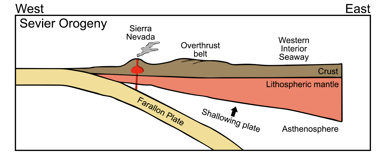
Diagram of the subduction of the Farallon plate during the Cretaceous Sevier Orogeny. The Wester Interior Seaway formed when the continental crust was downwarped in the central region of the North American continent. Diagram by Wade Greenberg-Brand, adapted from an image by the New Mexico Institute of Mining and Technology, originally published in the Teacher Friendly Guide to Earth Science series. Modified for Earth@Home.
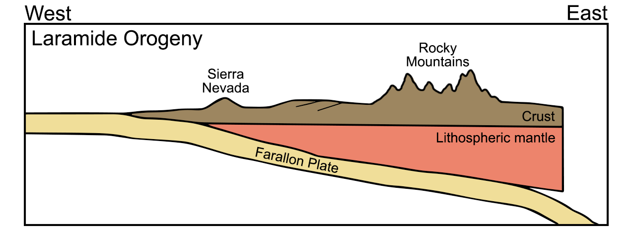
Diagram of the subduction of the Farallon plate during the Late Cretaceous to Paleogene Laramide Orogeny. During this orogeny, the Western Interior Seaway closed and the Rocky Mountains were uplifted. Diagram by Wade Greenberg-Brand, adapted from an image by the New Mexico Institute of Mining and Technology, originally published in the Teacher Friendly Guide to Earth Science series. Modified for Earth@Home.
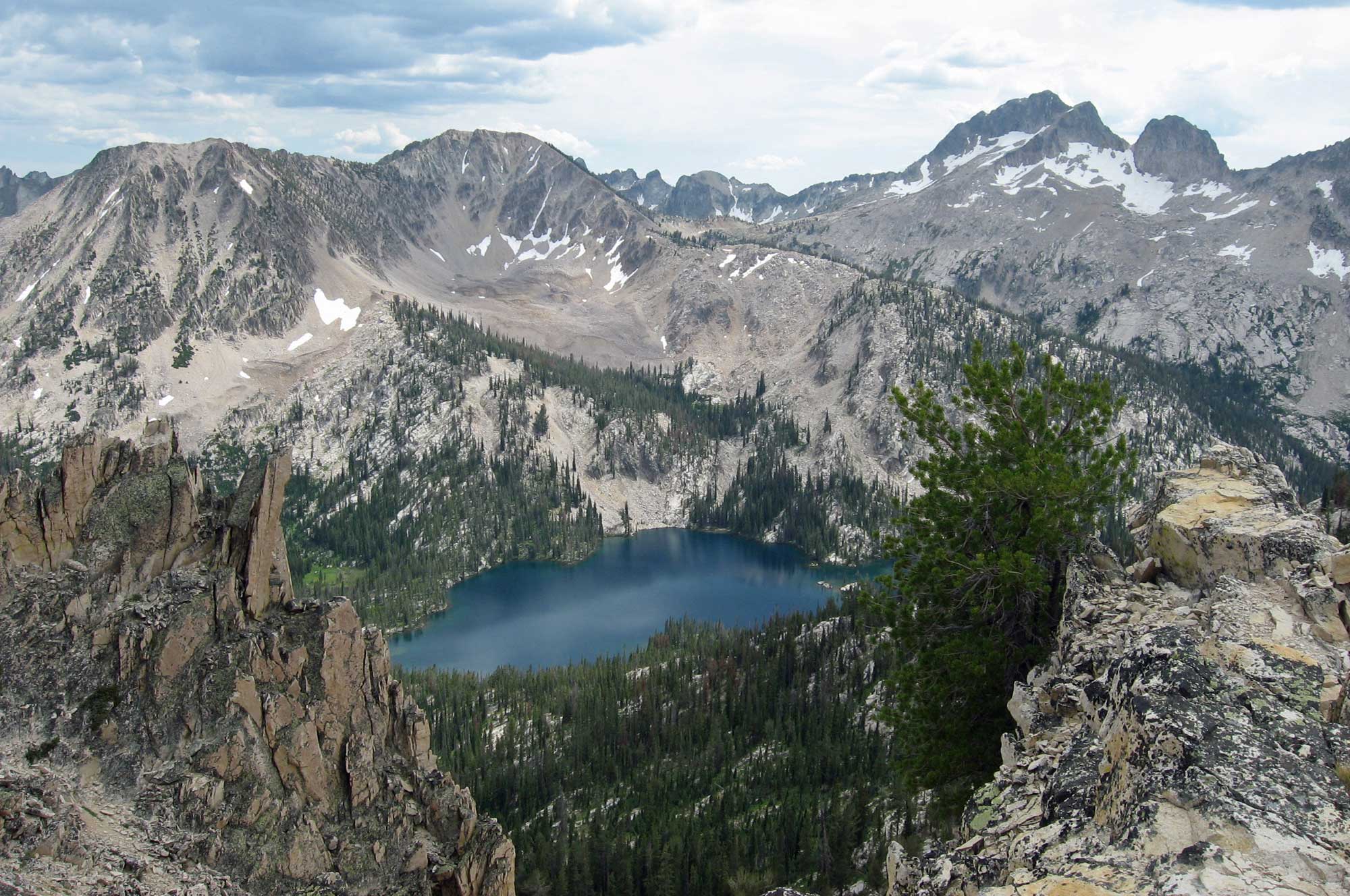
Toxaway Lake and flanking peaks made up of granite from the Idaho Batholith, Idaho. Photo by Fredlyfish4 (Wikimedia Commons, Creative Commons Attribution-ShareAlike 3.0 Unported license, image cropped and resized).
The end-Cretaceous extinction
The Cretaceous-Paleogene (K-Pg) boundary (previously known as the Cretaceous-Tertiary or K-T boundary) marks one of the most significant physical and biological events in Earth history. The boundary marks the contact between the Mesozoic and Cenozoic eras at around 65 million years ago, representing a time during which a large proportion (perhaps 50–70%) of all species of animals and plants abruptly became extinct. The boundary itself is rarely preserved in the geologic record, due to incomplete sedimentation and widespread erosion. However, the K-Pg boundary layer is preserved in places between the Hell Creek and Lance (or Fort Union) formations in the northwest-central region.
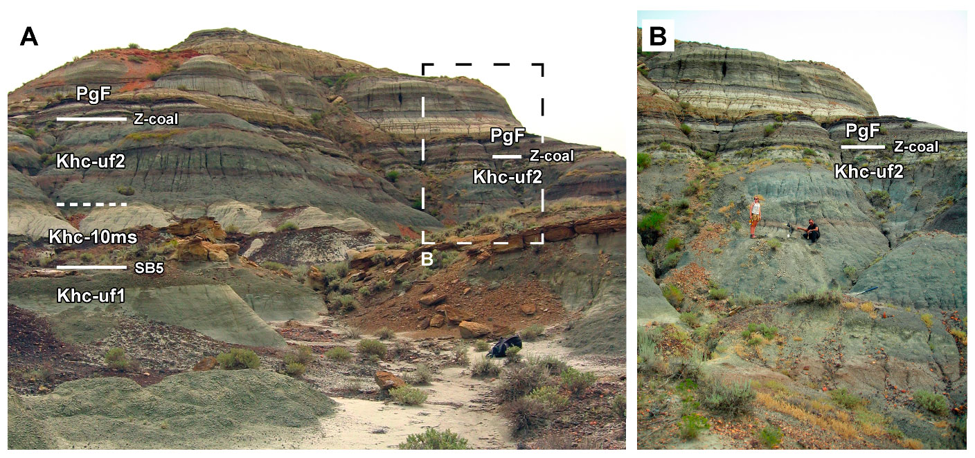
A butte near Jordan, Montana, that preserves the Z-coal marking the Cretaceous-Paleogene (K-Pg) boundary. Layers in the Cretaceous Hell Creek Formation are labeled Khc, whereas the overlying Paleogene Union Formation is labeled PgF. Source: Figure 21 from Fowler (2020) Geosciences 10(11) (Creative Commons Attribution 4.0 International license).
Cenozoic Era (66 million years ago to present)
Paleogene
During Cenozoic Era, the continents continued to spread apart to reach their present-day positions. Sea levels rose and fell, affecting the coastline, but the interior of North America remained relatively high. Sediment deposition, for the most part, occurred as fluvial and lake deposits. This was also a time of active volcanism in western North America.
Due to crustal deformation during the Mesozoic, several basins formed inland lakes or depressions into which sediments were deposited. The best-known example is the Green River Basin of western Wyoming, which is famous for its well-preserved Eocene fossils found in lakebed shales and mudstones.
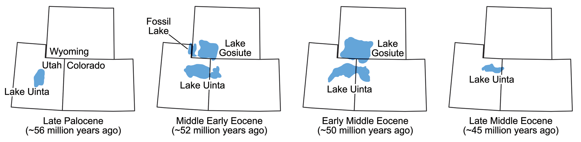
The size and location of various lakes in which the Green River Formation sediments were deposited during the Eocene epoch. Maps modified from maps by Wade Greenberg-Brand, originally published in The Teacher-Friendly Guide to the Earth Science of the Southwestern US, after figure 3 in L. Grande (2013) The Lost World of Fossil Lake.
Volcanic ashfall tuff from the Eocene, Green River Formation, Wyoming. Photograph by James St. John (Flickr; Creative Commons Attribution 2.0 Generic license).
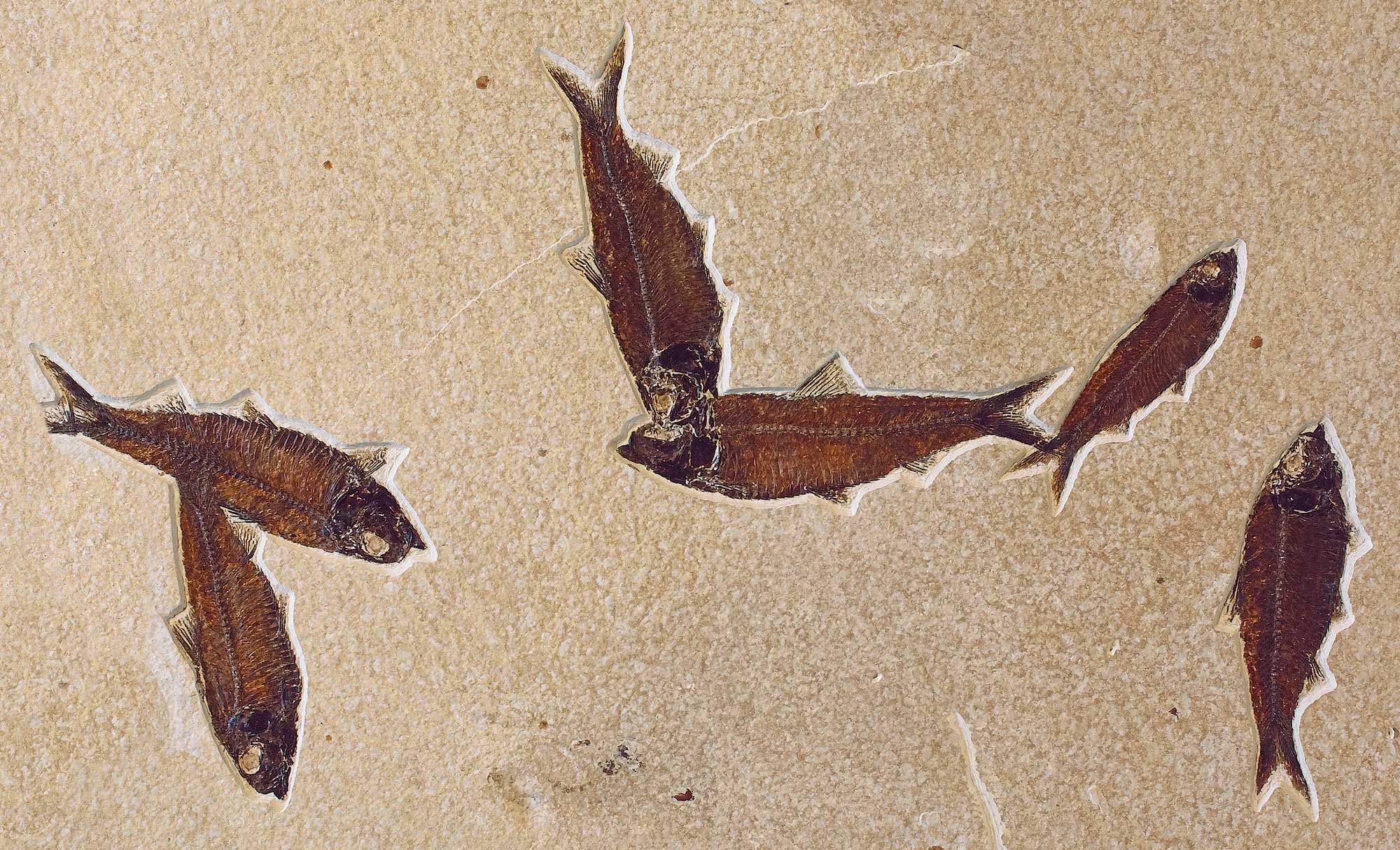
Slab showing mass mortality of Knightia eocaena, a freshwater fish similar to a herring, Fossil Lake, Wyoming. Photo by National Park Service (public domain).
Subduction along much of the U.S. West Coast ceased with the development of the San Andreas Fault System. Due to the complex interplay of plate motions, the portion of the subducting plate beneath the Southwest overrode hot, upwelling mantle. This, in turn, caused a number of major changes.
In the early Paleogene, melting of the lower crust resulted in the emplacement of numerous granitic bodies and volcanic eruptions across the northwest-central U.S., including the Absaroka Range in Wyoming and Montana and the Challis Volcanic Field in Idaho. These large packages of volcanic rocks also host important mineral deposits. Ash from these eruptions fell long distances from its source, and is a major component of terrestrial sediment on the Great Plains, much of which is abundantly fossiliferous.
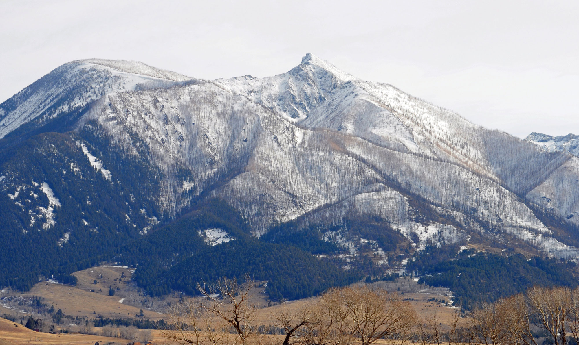
Mount Delano, Absaroka Range, Montana. Photo by Mike Cline (Wikimedia Commons, Creative Commons Attribution-ShareAlike 4.0 International license, image cropped and resized).
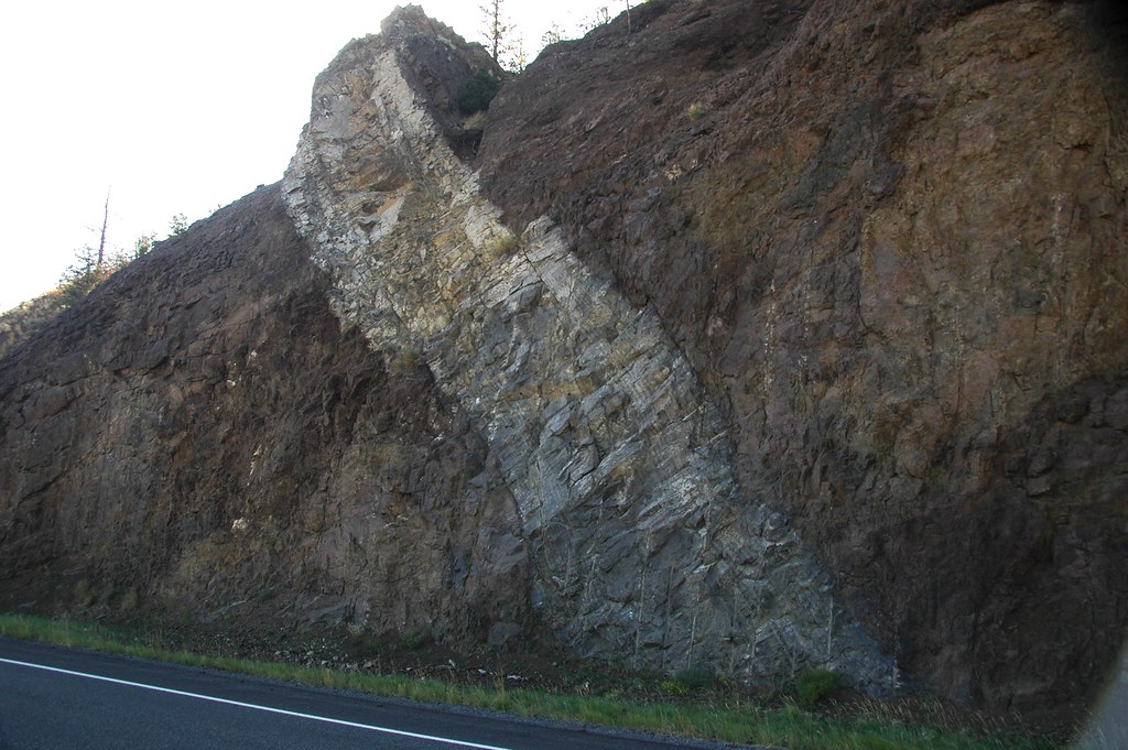
An andesite dike intrudes through a volcanic debris flow conglomerate exposed by a roadcut in the Absaroka Range, Wyoming. Photograph by James St. John (Flickr; Creative Commons Attribution 2.0 Generic license).
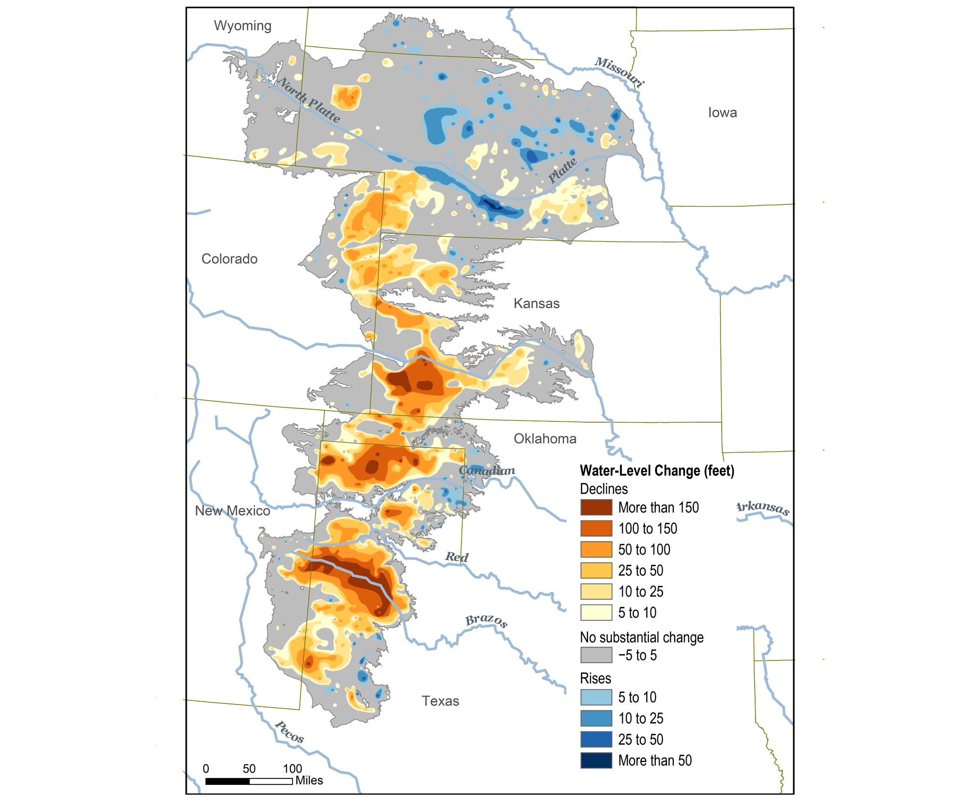
Original caption: "This map shows changes in Ogallala water levels from before the aquifer was tapped to 2015. Declining levels are red or orange, and rising levels are blue." Map from Climate.gov (NOAA).
Neogene
By the Neogene, the Farallon plate lay shallowly under the North American plate for hundreds of kilometers eastward of the West Coast. Now situated more fully beneath what are now the south-entral, southwestern, and northwest-central States, this extra layer of crust caused uplift and extension of the region, as the added thickness of buoyant rock (relative to the mantle) caused the entire area to rise isostatically.
The Farallon plate was subjected to increasing temperatures as it subducted, causing it to expand. As heat dissipated to the overlying North American plate, that rock expanded as well. Finally, the high temperatures in the upper mantle caused the Farallon plate to melt, and the resulting magma was injected into the North American plate, destabilizing it. These processes caused the surface of the North American plate to pull apart and fault into the mountainous blocks of the huge Basin and Range province that stretches from Idaho, Nevada and Utah into California, Arizona, New Mexico, and Texas.
At the end of the Neogene, around eight million years ago, epeirogenic uplift (resulting from upwelling mantle heat pushing the crust upwards) began, raising the Rocky Mountains and Colorado Plateau to its current “mile-high” elevation. Another example of downcutting is the more recent development, 500,000 years ago, of the Badlands in South Dakota, where Cretaceous and Cenozoic sedimentary rocks are eroded into badland topography.
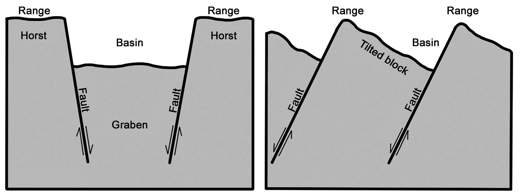
Alternating basins and ranges were formed during the past 17 million years by gradual movement along faults. Arrows indicate the relative movement of rocks on either side of a fault. Image modified from original by Wade Greenberg-Brand, in turn adapted from an image by the USGS (public domain).
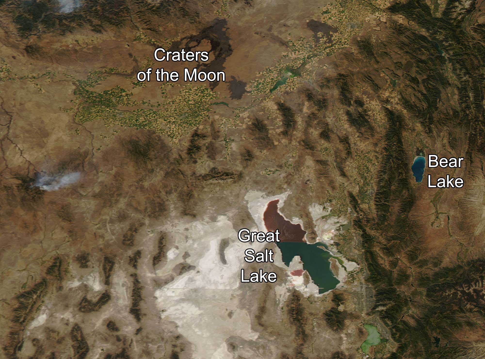
Satellite image of the Snake River Plain (the river can be identified by the patches of farmland that follow its course) and the Basin and Range in the Idaho-Utah border region. Photo source: NASA Earth Observatory (used following NASA's image use policy).
Yellowstone Hot Spot (16.5 million years ago to recent)
The development of the Yellowstone hot spot appears to have begun with the eruption of the voluminous Columbia Plateau flood basalts in present-day Washington and Oregon around 16.5 million years ago. As the North American plate traveled over this mantle plume, the crust melted and produced a trail of volcanic rock that crosses southern Idaho, forming the Snake River Plain, and ending at Yellowstone National Park in northwestern Wyoming.
The trail of volcanic eruptions from the hot spot works its way east along this path, with major explosive caldera eruptions occurring on a cycle of around 600,000 years. Multiple minor eruptions occur between the larger explosions. For example, Craters of the Moon National Monument in southern Idaho is a recent (15,000- to 2000-year-old) volcanic flow associated with rift zones formed by the Yellowstone hot spot. The youngest caldera is at Yellowstone National Park and is 630,000 years old. It contains many younger minor volcanic flows and domes.
Due to its recent history of volcanism, Yellowstone has been classified as a supervolcano. While there is concern that the hot spot could generate another violent eruption, researchers using seismic tomography have not observed large volumes of melt below the area that could result in a large eruption. The hot spot has now reached a boundary of thicker overlying crust, which will significantly affect the amount and timing of the melt it produces. The odds of an explosive eruption occurring during the next several thousand years are very low.
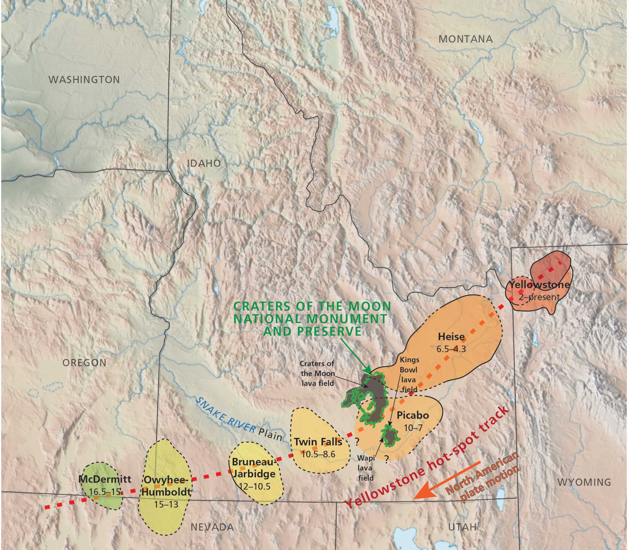
Map showing the track of the Yellowstone Hot Spot, with the location of Craters of the Moon National Monument and Preserve marked. Map by Trista Thornberry-Ehrlich, Colorado State University (National Park Service, public domain).
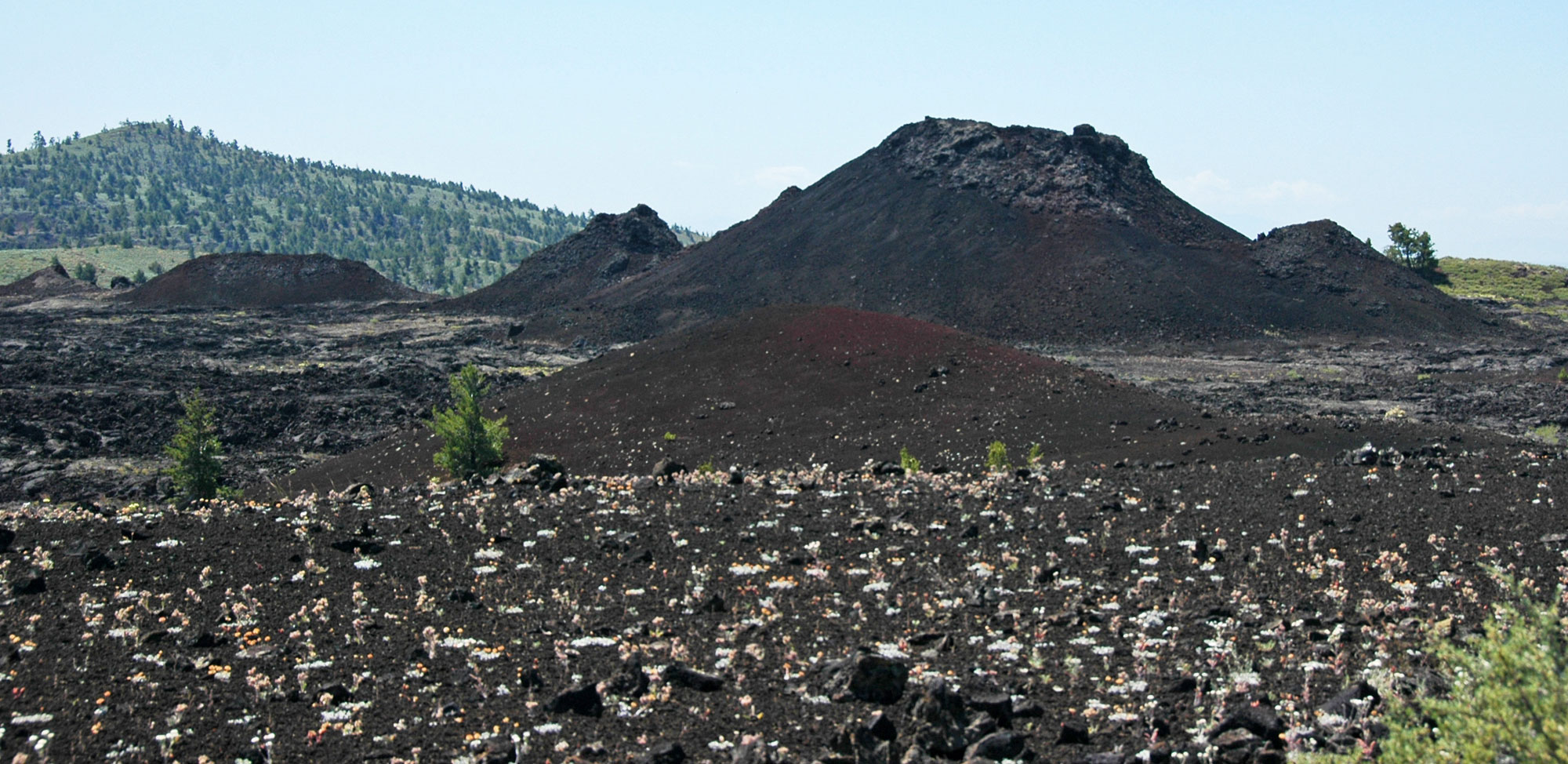
Volcanic spatter cones, Craters of the Moon National Monument and Preserve, Idaho. Photo by James St. John (flickr, Creative Commons Attribution 2.0 Generic license, image cropped and resized).
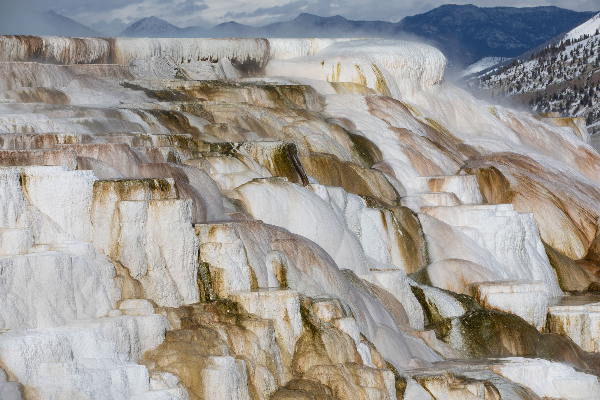
Mammoth Hot Springs, Yellowstone National Park. Photo by Diane Renkin, NPS (National Park Service, public domain).
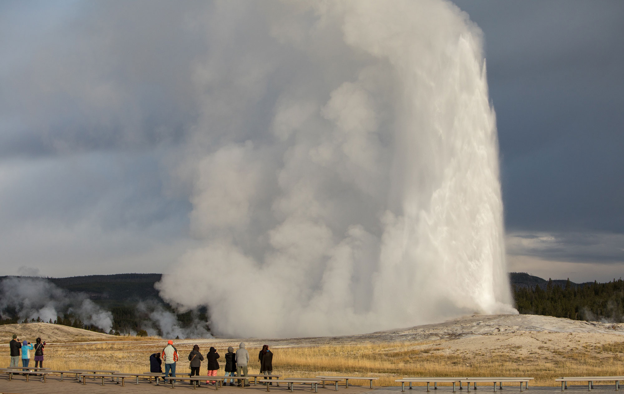
Old Faithful, Yellowstone National Park. Photo by Jim Peaco, NPS (National Park Service, public domain).
Quaternary (2.6 million years ago to present)
At the start of the Quaternary period, about 2.5 million years ago, continental ice sheets began to form in northernmost Canada. Throughout this period, the northern half of North America has been periodically covered by continental glaciers that originated in northern Canada. The Quaternary period is divided into two epochs: the Pleistocene and Holocene. During the Pleistocene, ice sheets advanced south and retreated north several dozen times, reaching their maximum extent most recently 25,000–18,000 years ago. The Holocene epoch is the most recent (and current) period of retreat, and is referred to as an interglacial interval. The beginning of the Holocene is considered to be 11,700 years ago, or about 9700 BCE.
During the Pleistocene, a continental glacier that originated in Canada migrated southwards toward the United States. During this time, the Laurentide Ice Sheet reached into Montana, the Dakotas, Nebraska, Kansas, and east into the Great Lakes. The Cordilleran Ice Sheet reached into Washington, Idaho, and western Montana. Alpine glaciers covered the mountain heights in Idaho, Montana, Wyoming, Utah, Colorado, and New Mexico, as well as the Cascades and Sierra Nevada in the western states.
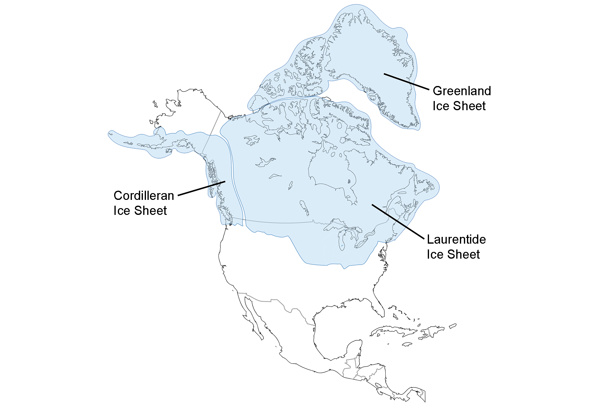
Extent of glaciation over North America at the Last Glacial Maximum. Image adapted from map by the USGS (public domain).
Glacial lakes formed in low areas between or in front of glaciers, and also during times between glacial advances. These lakes included Lake Missoula in Montana and Lake Agassiz in south-central Canada, Minnesota, and North Dakota. The catastrophic release of an ice dam on Lake Missoula carved the Channeled Scablands in northern Idaho and eastern Washington.
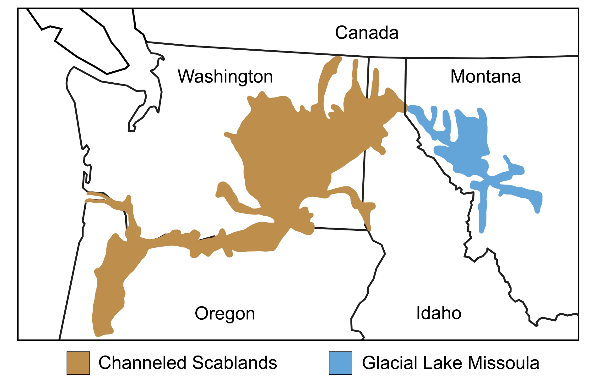
Map showing the extent of glacial Lake Missoula and the Channeled Scablands. Map modified from a map by Wade Greenberg-Brand, adapted from image by the Montana Natural History Center, originally published in The Teacher-Friendly Guide to the Earth Science of the Northwest Central US.
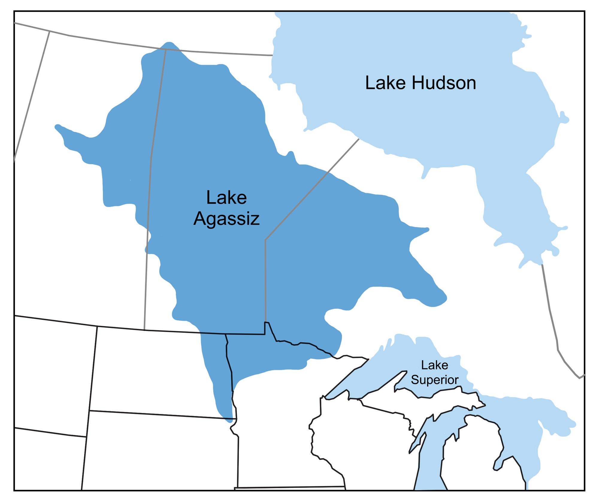
Map showing the extent of glacial Lake Agassiz. Map modified from a map by Wade Greenberg-Brand, originally published in The Teacher-Friendly Guide to the Earth Science of the Northwest Central US.
Effects of glaciation on the northwest-central U.S. landscape include carved glacial cirques and valleys, and deposits of glacial till in moraines and outwash plains. Glacier National Park in Montana contains many good examples of these features. Fine silt from glacier-ground rock was picked up from the glacial outwash by wind and deposited in thick layers of loess across large areas of the mid-continental U.S. Sand dunes, formed where a supply of outwash sand was picked up and blown by the wind, include the Sandhills of Nebraska and Killpecker Sand Dunes in Wyoming.
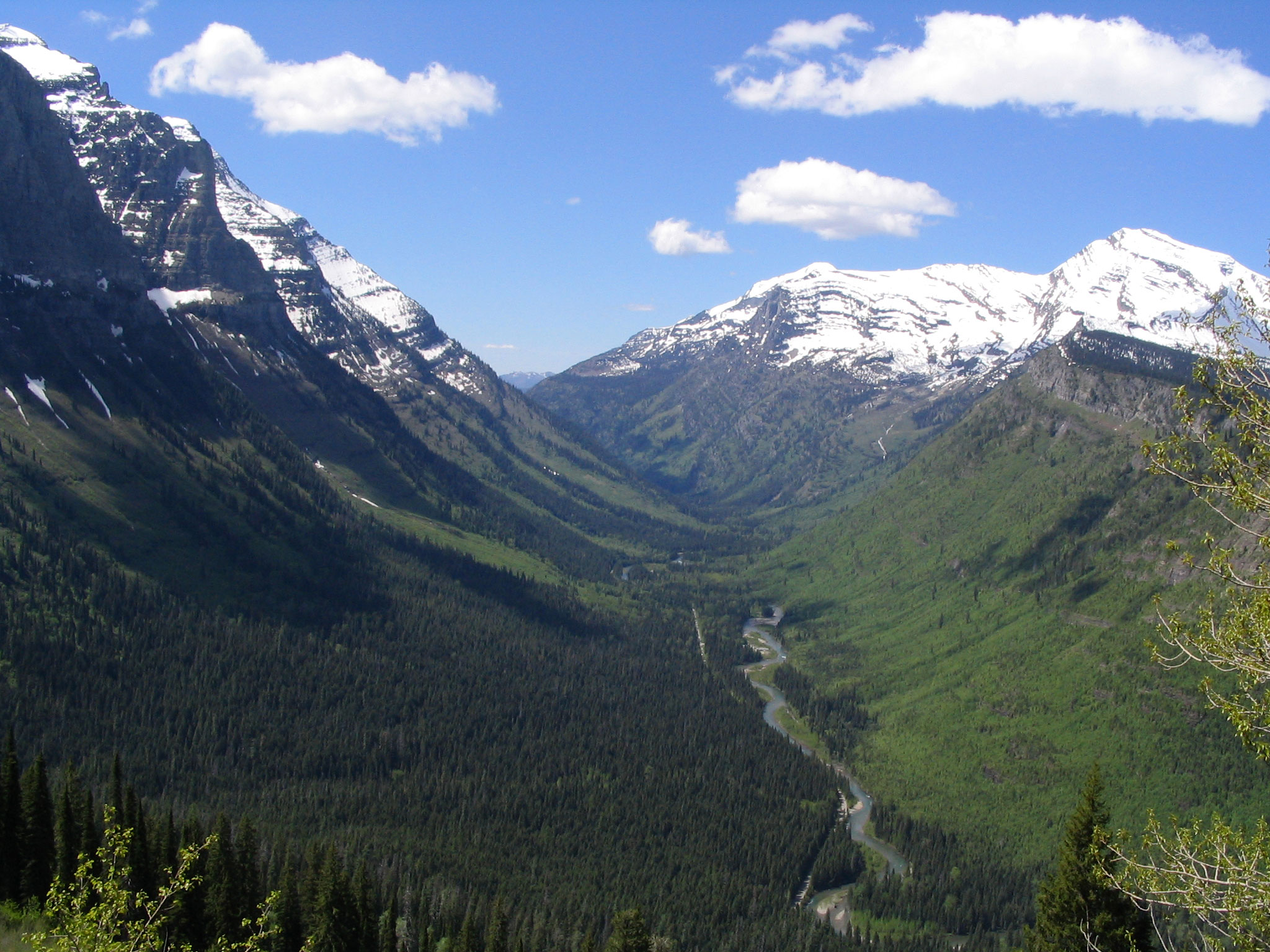
U-shaped Valley, Going-to-the-Sun Road, Glacier National Park, Montana, 2005. Photo by Ken Lund (flickr, Creative Commons Attribution-ShareAlike 2.0 Generic license).
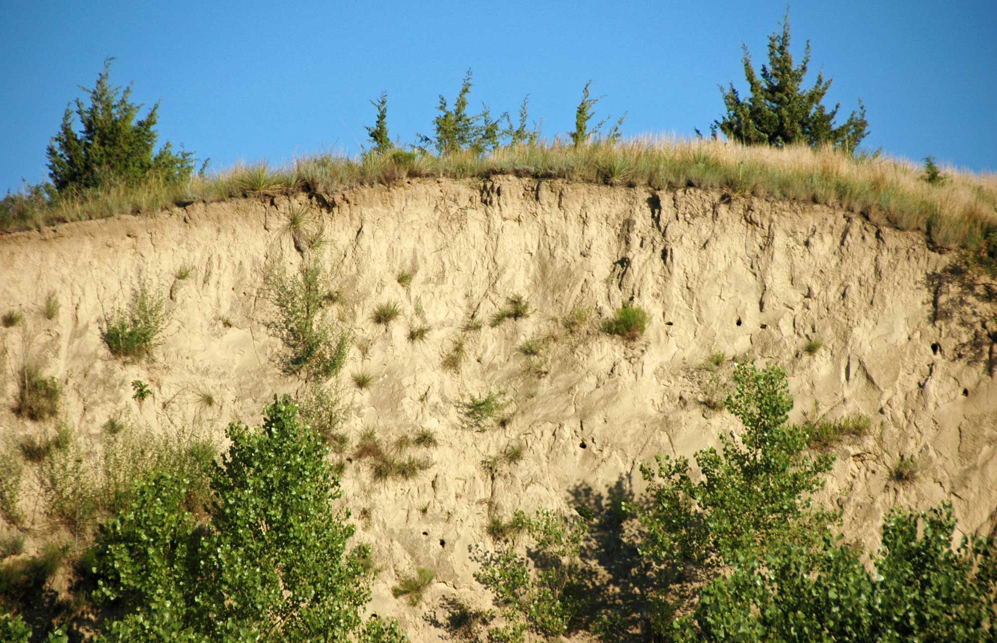
Exposure of Peoria Loess, which dates to the Wisconsinan glacial interval, in the Loess Canyons or Loess Plains region southeast of North Platte, Nebraska. Photo by James St. John (flickr, Creative Commons Attribution 2.0 Generic license, image resized).
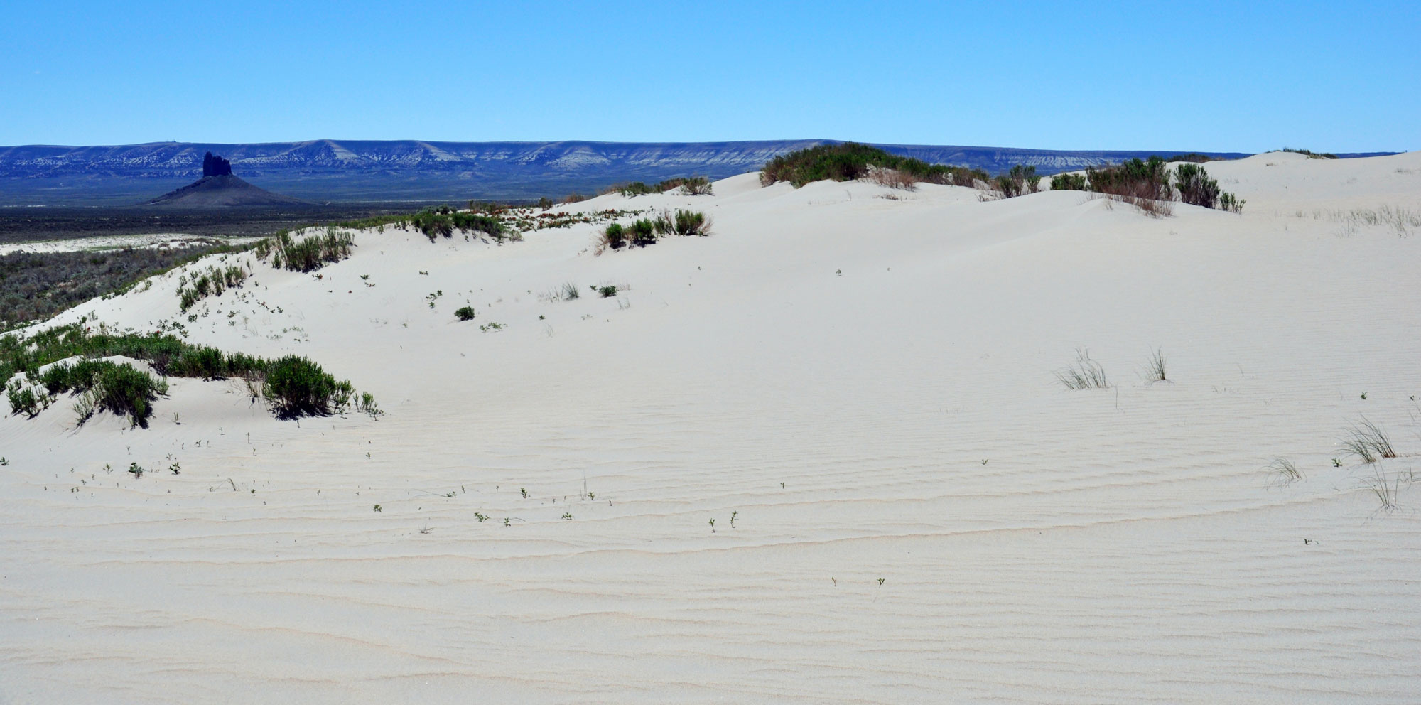
Killpecker Sand Dunes, Wyoming. Photo by James St. John (flickr, Creative Commons Attribution 2.0 Generic license, image cropped and resized).
The ice age continues today, but the Earth is in an interglacial stage, since the ice sheets have retreated for now. The current interglacial period has slowed both erosional and depositional processes. The glacial-interglacial cycling of ice ages indicates that the world will return to a glacial stage in the future, that is unless the impacts of human-induced climate change radically shift these natural cycles.
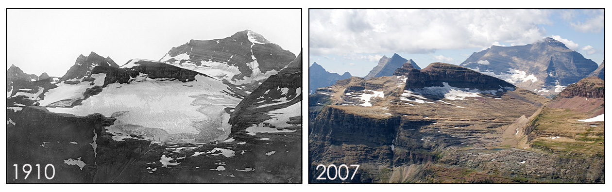
Boulder Glacier in 1910 and 2007, Glacier National Park, Montana. Photos by Morton Elrond/University of Montana Collection (1910) and Fagre/Pederson/USGS (2007). Source: USGS (public domain).
Resources
Earth@Home: Here on Earth: Introduction to Plate Tectonics: https://earthathome.org/hoe/plate-tectonics