

Snapshot: Overview of the topography of the Basin and Range region of the southwestern United States.
Topics covered on this page: Overview; Great Basin; Sonoran Desert; Mexican Highland; Resources.
Credits: Most of the text of this page is derived from "Topography of the Southwestern US" by Bryan L. Isacks, Richard A. Kissel, and Warren D. Allmon, chapter 4 in The Teacher-Friendly Guide to the Earth Science of the Southwestern US, edited by Andrielle N. Swaby, Mark D. Lucas, and Robert M. Ross (published in 2016 by the Paleontological Research Institution). The book was adapted for the web by Elizabeth J. Hermsen and Jonathan R. Hendricks in 2021–2022. Changes include formatting and revisions to the text and images. Credits for individual images are given in figure captions.
Updates: Page last updated April 7, 2022.
Image above: Gypsum sand dunes at White Sands National Monument in New Mexico. Photograph by Robert Shea (Flickr; Creative Commons Attribution-NonCommercial 2.0 Generic license; image cropped and resized).
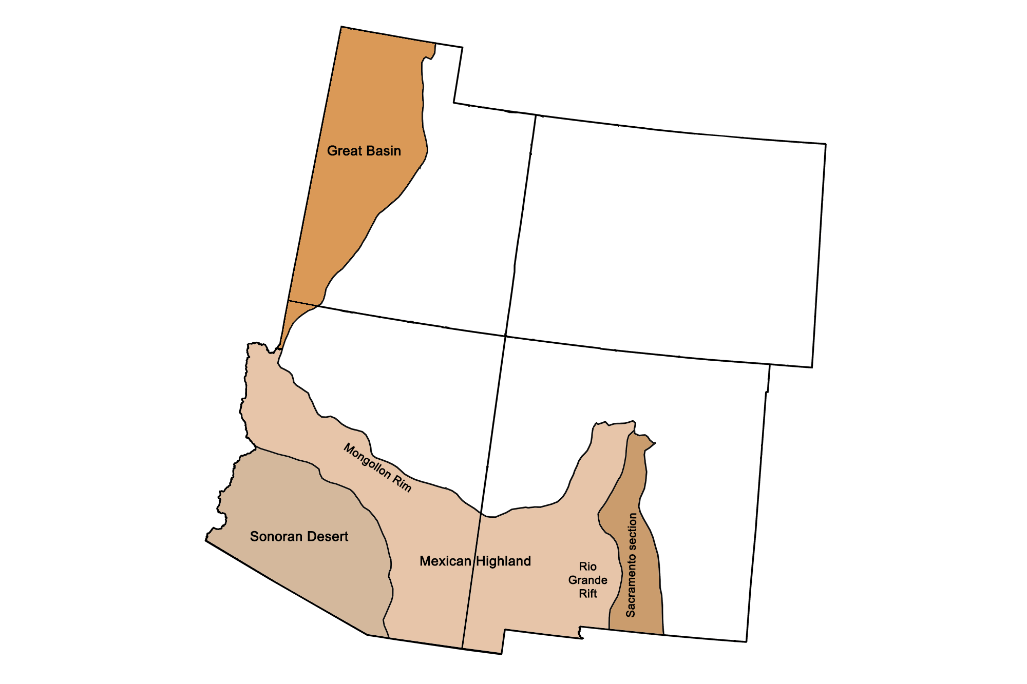
Physiographic subdivisions of the Basin and Range. Image by Jonathan R. Hendricks for the Earth@Home project.
Overview
In the Southwest, the Basin and Range stretches along the western sides of Utah and Arizona as well as the southern parts of Arizona and New Mexico. The entire Basin and Range region covers a massive expanse of land, stretching from Idaho and southeastern Oregon through all of Nevada, southeastern California, and extending into western Texas and Mexico.
The Basin and Range is characterized by rapid changes in elevation alternating from flat and dry basins to narrow, faulted mountains. This pattern of many parallel, north-south mountain ranges found throughout the region inspired geologist Clarence Dutton to famously observe that the topography of the Basin and range appeared “like an army of caterpillars crawling northward.” The formation of this topography is directly related to tectonic forces that led to crustal extension (pulling of the crust in opposite directions).
After the Laramide Orogeny ended in the Paleogene, tectonic processes stretched and broke the crust as California's San Andreas fault system began to develop, and the upward movement of magma weakened the lithosphere from underneath. Approximately 20 million years ago, the crust along the Basin and Range stretched, thinned, and faulted into some 400 mountain blocks. The pressure of the mantle below uplifted some blocks, creating elongated peaks and leaving the lower blocks below to form down-dropped valleys. The boundaries between the mountains and valleys are very sharp, both because of the straight faults between them and because many of those faults are still active. These peaks and valleys are also called horst and graben landscapes.
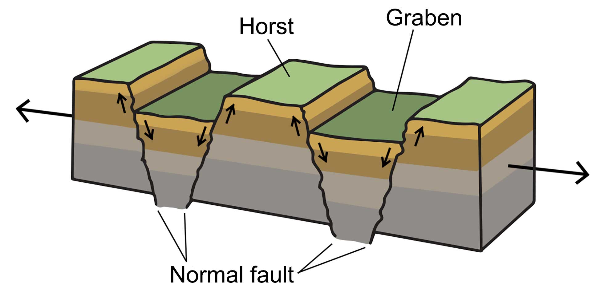
A horst and graben landscape occurs when the crust stretches, creating blocks of lithosphere that are uplifted at angled fault lines. Image by Wade Greenberg-Brand, modified for the Earth@Home project.
Such landscapes frequently appear in areas where crustal extension occurs, and the Basin and Range is often cited as a classic example thereof. In the Basin and Range, the crust has been stretched by up to 100% of its original width. The distance between the Sierra Mountains of California and the Colorado Plateau increased by over 320 kilometers (200 miles) as a result of this crustal extension. Due to the stretching, the average crustal thickness of the Basin and Range is 30–35 kilometers (19–22 miles), compared with a worldwide average of approximately 40 kilometers (25 miles).
There is a marked change in elevation between the northern and southern portions of the Basin and Range. In Utah, the Great Basin is in the range of 1200 to 2100 meters (4000 to 7000 feet) in elevation, while the Sonoran Desert in Arizona is mostly 150 to 600 meters (500 to 2000 feet) above sea level.
The Great Basin
Utah's western half is part of the Great Basin, an area that spans most of Nevada and reaches into California, Oregon, and Idaho.
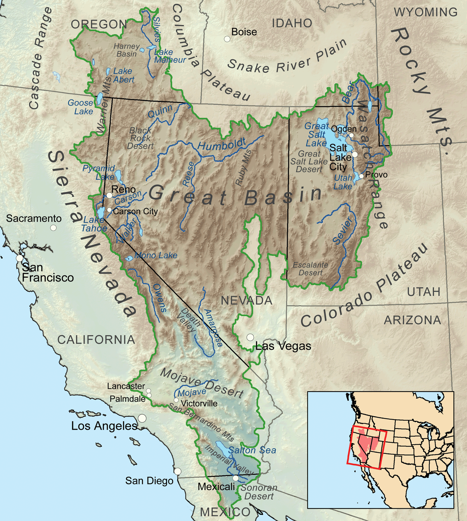
The extent of the Great Basin. Image by "Kmusser" (Wikimedia Commons; Creative Commons Attribution-ShareAlike 3.0 Unported license).
The Great Basin is bounded on all sides by topographical features—the Wasatch Range in Utah, the Sierra Nevada and Cascades in California, and the Snake River Basin to the north—that prevent it from having any outlet to the ocean. As such, the Basin drains internally; that is, all water in the region evaporates, flows into lakes, or sinks underground. Because there are no flow outlets and water typically leaves lakes via evaporation (allowing minerals to concentrate), many of the area's lakes are saline. In Utah, the Great Basin largely drains into the Great Salt Lake, which receives considerable runoff from the Wasatch Range.
"What Makes Great Salt Lake So Great?" by Smithsonian Channel (YouTube).
Today, the Great Salt Lake is the largest saltwater lake in the Western Hemisphere and the largest remnant of Lake Bonneville, a large, deep pluvial lake that covered much of western Utah during the Pleistocene. As the lake evaporated, salts were concentrated in the remaining water, then left behind with the muds as the final water evaporated from low areas. The present day Great Salt Lake has a saline content of approximately 13% (depending on lake level) and contains approximately 4.1 billion metric tons (4.5 billion tons) of salt. Deltas and shoreline deposits from Lake Bonneville remain visible on the slopes of the Wasatch Mountains, and their elevations provide measurements of the area's isostatic rebound after the lake receded and the weight of its water was removed from the land.
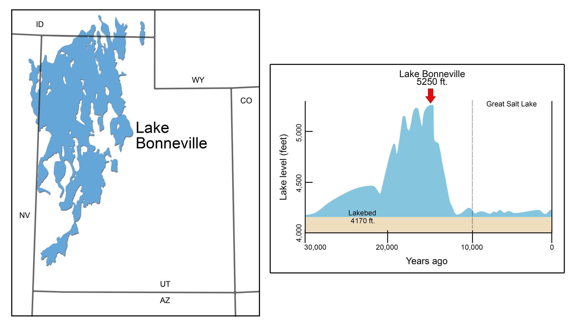
Pleistocene Lake Bonneville. Left: Lake Bonneville's maximal extent during the Pleistocene. Right: Graph of the lake's changing level over time. Modified from illustrations by Wade Greenberg-Brand originally published in The Teacher-Friendly Guide to the Earth Science of the Southwestern US.
Other, smaller remnants of Lake Bonneville include Rush Lake, Sevier Lake, and Utah Lake, as well as the Bonneville Salt Flats and the Escalante Desert Valley.
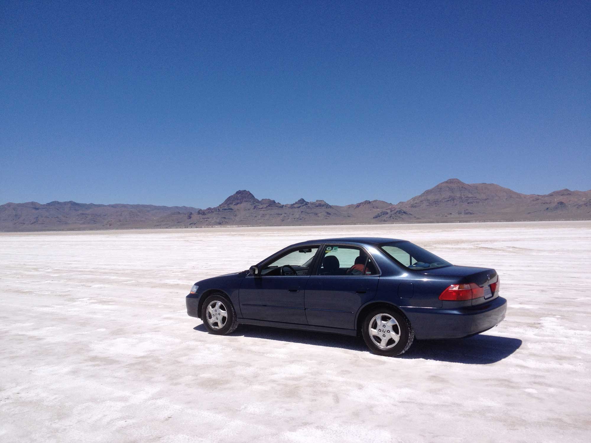
The Bonneville Salt Flats International Speedway. Photograph by Jonathan R. Hendricks.
Sonoran Desert
Arizona's southwestern corner is occupied by the Sonoran Desert, the second hottest desert in North America (after the Mojave Desert, which includes Death Valley). The area is characterized by steep, blocky mountain ranges and intervening flat desert basins, as well as intermittent streams and alluvial fans formed when heavy rainstorms transport eroded material.
During extension of the Basin and Range in southern Arizona, the overlying sedimentary rocks were stretched so much that underlying metamorphic rocks were exposed. These rocks are called metamorphic core complexes (MCCs), and they consist of metamorphic rock bodies that formed deep in the crust before moving to the surface along low-angle faults. MCCs are usually the highest topography in the area, but are also domed and frequently do not match the form of other nearby mountains, which have modest relief (300 to 600 meters [1000 to 2000 feet]) and are nearly buried in their eroded detritus. This extremely resistant metamorphic rock, along with patches of volcanics, are responsible for many small mountain ranges that do not follow the mostly north-south pattern of narrow ridges so characteristic of the rest of the Basin and Range. Large intervening basins, filled with eroded sediment from the mountains, are drained by the Gila River into the Colorado River. Saguaro National Park is located close to an especially prominent example, forming the Rincon and Santa Catalina mountains near Tucson.
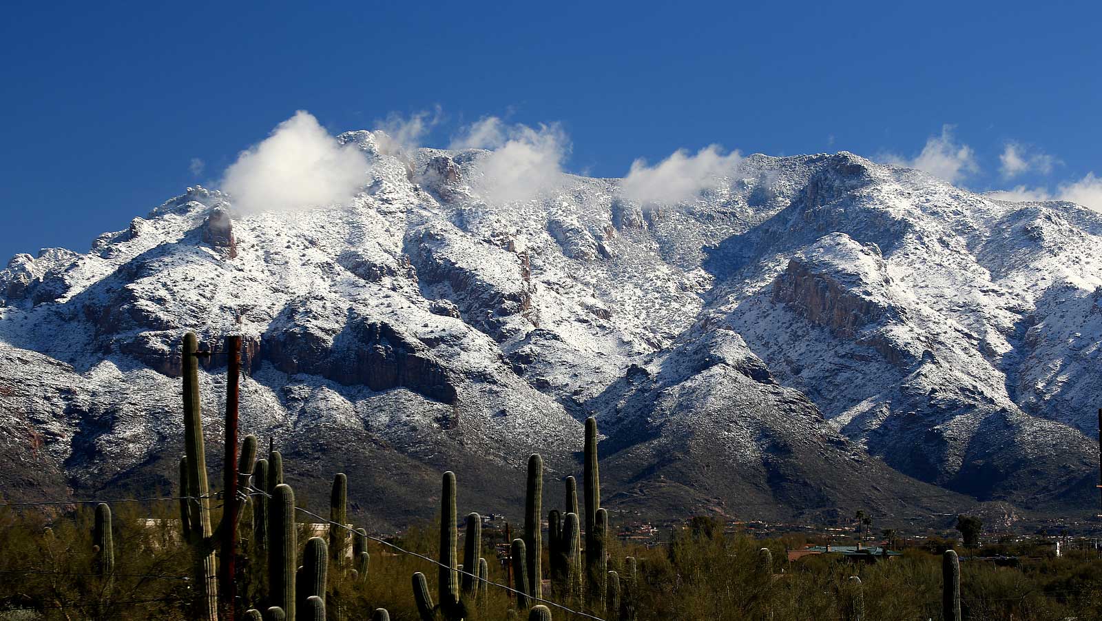
The heavily eroded Santa Catalina Mountains near Tucson, Arizona are surrounded by forests of saguaro cacti. The highest point in these mountains has a relief of 1572 meters (5157 feet) over the surrounding landscape, and the mountains are tall enough to receive snowfall. Photograph by Bill Morrow (Flickr; Creative Commons Attribution 2.0 Generic license).
A band of MCCs stretches from southeastern Arizona to the junction of its borders with California and Nevada; the pattern continues north through eastern Nevada, then reemerges in Utah's northwestern corner.
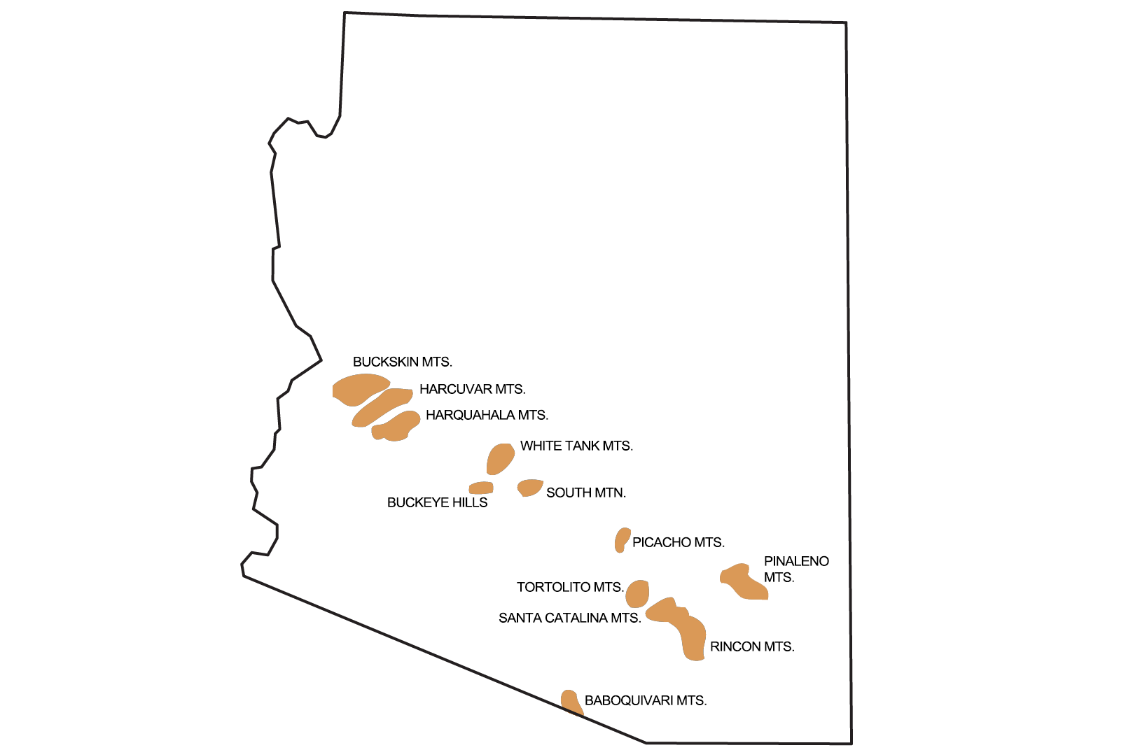
Distribution of metamorphic core complexes in Arizona. Image by Andrielle Swaby, modified for the Earth@Home project.
Mexican Highland
The Mexican Highlands, extending from eastern Arizona into western New Mexico, contains Basin and Range structures with higher relief and higher basin elevations, similar to those of the Great Basin. Desert grasslands surround the highlands' isolated mountain ranges, and the area also includes a number of volcanic structures.
The Mogollon-Datil Volcanic Field in southeastern Arizona and southwestern New Mexico includes mid-Cenozoic volcanic andesites, tuff, rhyolites, and basalts that extend into the complexly faulted area where the Basin and Range melds into the Rio Grande Rift zone. The deeply eroded remains of a number of silicic calderas have been identified, including the Mogollon Mountains whose peaks reach nearly 3350 meters (11,000 feet). This volcanic field includes part of the Continental Divide between the Gila and the Rio Grande rivers.
Mogollon Rim
The Mogollon Rim is a major escarpment that forms the southern edge of the Colorado Plateau, extending approximately 320 kilometers (200 miles) through Arizona and into New Mexico (see map at top of page). Erosion and faulting have carved dramatic canyons into the rim, and Carboniferous and Permian sandstone and limestone form spectacular high cliffs. The Mogollon Rim rises approximately 1200 meters (4000 feet) above the land to the south.
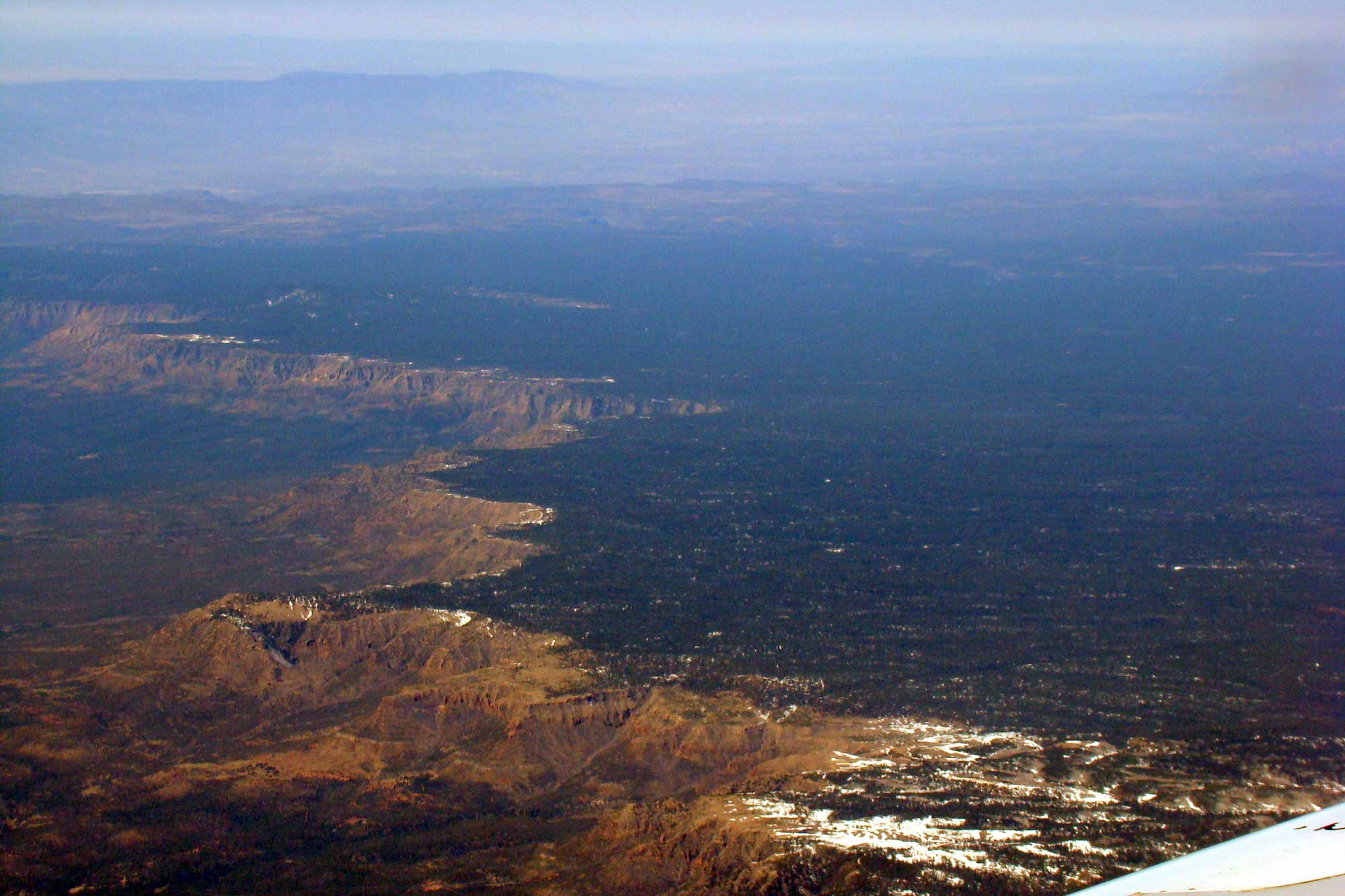
Photograph from an airplane of the Mogollon Rim in Arizona. Photograph by Anita Gould (Flickr; Creative Commons Attribution-NonCommercial 2.0 Generic license; image cropped, resized, and colors enhanced to highlight features).
Rio Grande Rift
The Basin and Range of New Mexico is dominated by the Rio Grande Rift, a zone of extension in the continental crust running from New Mexico north into Colorado (see map at top of page). A small amount of true crustal spreading occurred in this narrow area, resulting in an elongate depression bounded by faults, which also controls the course of the Rio Grande River. Magma erupting through the rift resulted in adjacent volcanic fields, as well as volcanic fill, that cover the rift valley floor. Faulting of the Rio Grande Rift also reaches into and affects the topography of the Colorado-New Mexico Rocky Mountains.
The Rio Grande Rift began to form approximately 30 million years ago, peaked from 16 to 10 million years ago, and remains tectonically active today. One recent eruption, the 5000-year-old Carrizozo Malpais, resulted in a 75-kilometer-long (47-mile-long) flow of black basalt that filled the Tularosa Basin and contains lava tubes, collapse pits, wrinkles, and fissures.

Ropy, pahoehoe basalt formations in the Valley of Fires in New Mexico. Photograph by "BFS Man" (Flickr; Creative Commons Attribution-NonCommercial 2.0 Generic license).
The Carrizozo Malpais is considered to be one of the youngest lava flows in the continental U.S.
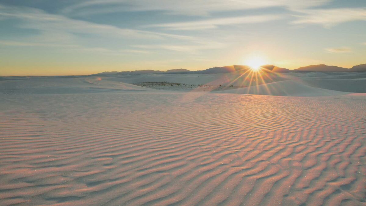
Directly south of the Carrizozo Malpais lies a famous non-volcanic feature, the White Sands National Monument. This is the largest gypsum dune field in the world, covering an area of 710 square kilometers (275 square miles) in southern New Mexico.
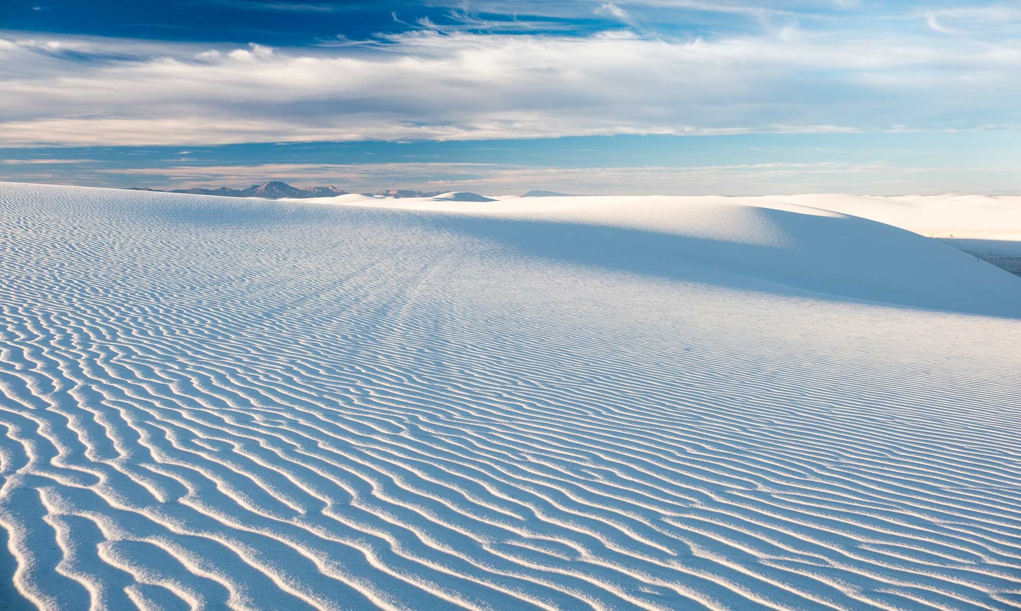
Windblown gypsum dunes of the White Sands National Monument, New Mexico. The dune field began forming 25,000 years ago. Photograph by Robert Shea (Flickr; Creative Commons Attribution-NonCommercial 2.0 Generic license; image resized).
The dunes are composed of windblown gypsum grains, eroded from Permian Basin evaporite deposits in the surrounding San Andres Mountains. Gypsum is water-soluble, and is found in sand form only rarely; White Sands has endured thanks to the area's aridity and the fact that the Tulsarosa Basin has no outlet to the sea.