

Page snapshot: Introduction to the geologic history of the western U.S. from the Precambrian to the Quaternary Period.
Topics covered on this page: The big picture; Precambrian and Paleozoic; Neoproterozoic; Paleozoic; Mesozoic; Farallon plate; Nevadan, Sevier, and Laramide orogenies; Western Interior Seaway; Cenozoic; Southern and Central California and Basin and Range; San Andreas Fault; Basin and Range; Sierra Nevada mountains; Northern California, Oregon, and Washington; Cascadia subduction zone; Yellowstone hotspot and Columbia River basalts; Alaska; Quaternary; Last glacial advance; Holocene; Resources.
Credits: Much of the text of this page is derived from "Geologic history of the Southwestern US" by Frank D. Granshaw, Alexandra Moore, and Gary Lewis, chapter 1 in The Teacher-Friendly Guide to the Earth Science of the Western US, edited by Mark D. Lucas, Robert M. Ross, and Andrielle N. Swaby (published in 2014 by the Paleontological Research Institution; currently out of print). The book was adapted for the web by Elizabeth J. Hermsen and Jonathan R. Hendricks in 2022. Changes include formatting and revisions and additions to the text and images. Credits for individual images are given in figure captions.
Updates: Page last updated September 8, 2022.
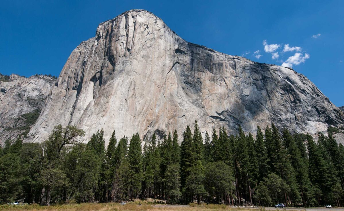
Image above: El Capitan, part of a Cretaceous-aged batholith exposed in Yosemite National Park, Sierra Nevada mountains, eastern California. Photo by William Warby (flickr, Creative Commons Attribution 2.0 Generic license, image resized).
The Big Picture
The geologic history of the western United States is a saga of moving continents and climate change that produced shifting coastlines, rising and eroding mountain chains, and ever-changing ecosystems. Though much of it is geologically young, its rocks and landscapes record over half a billion years of Earth history. Furthermore, it is a place where nearly all the processes that shaped it are still visible at some level. The western states are divided up into six different geologic provinces: 1) the Basin and Range, 2) the Columbia Plateau, 3) the Rocky Mountains, 4) the Cascade-Sierra Mountains, 5) the Pacific Border, and 6) Alaska.

Physiographic regions of the western United States as covered in this section.
Subduction zones
The western states are all on active plate margins. In the case of Alaska and the Washington-Oregon-northern California region, thin oceanic crust is colliding with the thicker continental crust of the North American plate. As it does so, sediment, sedimentary rock, and even bits of the oceanic crust itself are scraped off the descending crustal plate and pushed onto the overlying plate, forming an accretionary wedge. Just as a rug develops folds when pushed from the side, these rocks are wrinkled up into mountains like the Oregon Coast Range and the Olympic Mountains of Washington.
Farther inland, as the oceanic crust descends deep into the upper mantle, the rock above the descending crust melts and forms a line of volcanoes on the surface. This process, called subduction, is responsible for creating the Cascades of Oregon and Washington as well as the Aleutian Islands and Wrangell Mountains of southern Alaska.
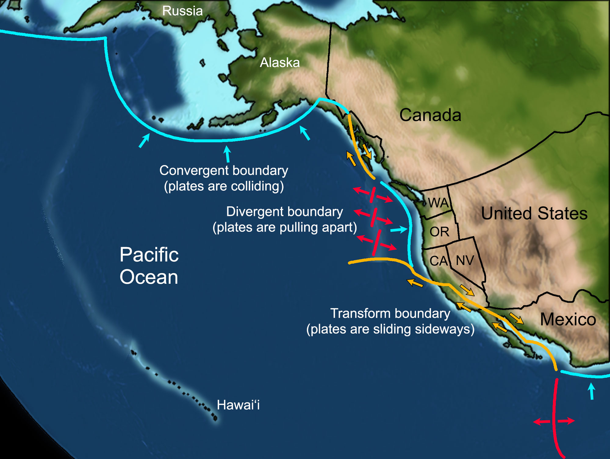
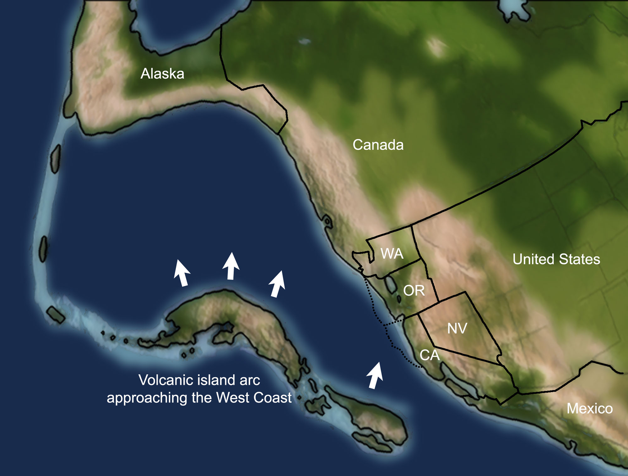
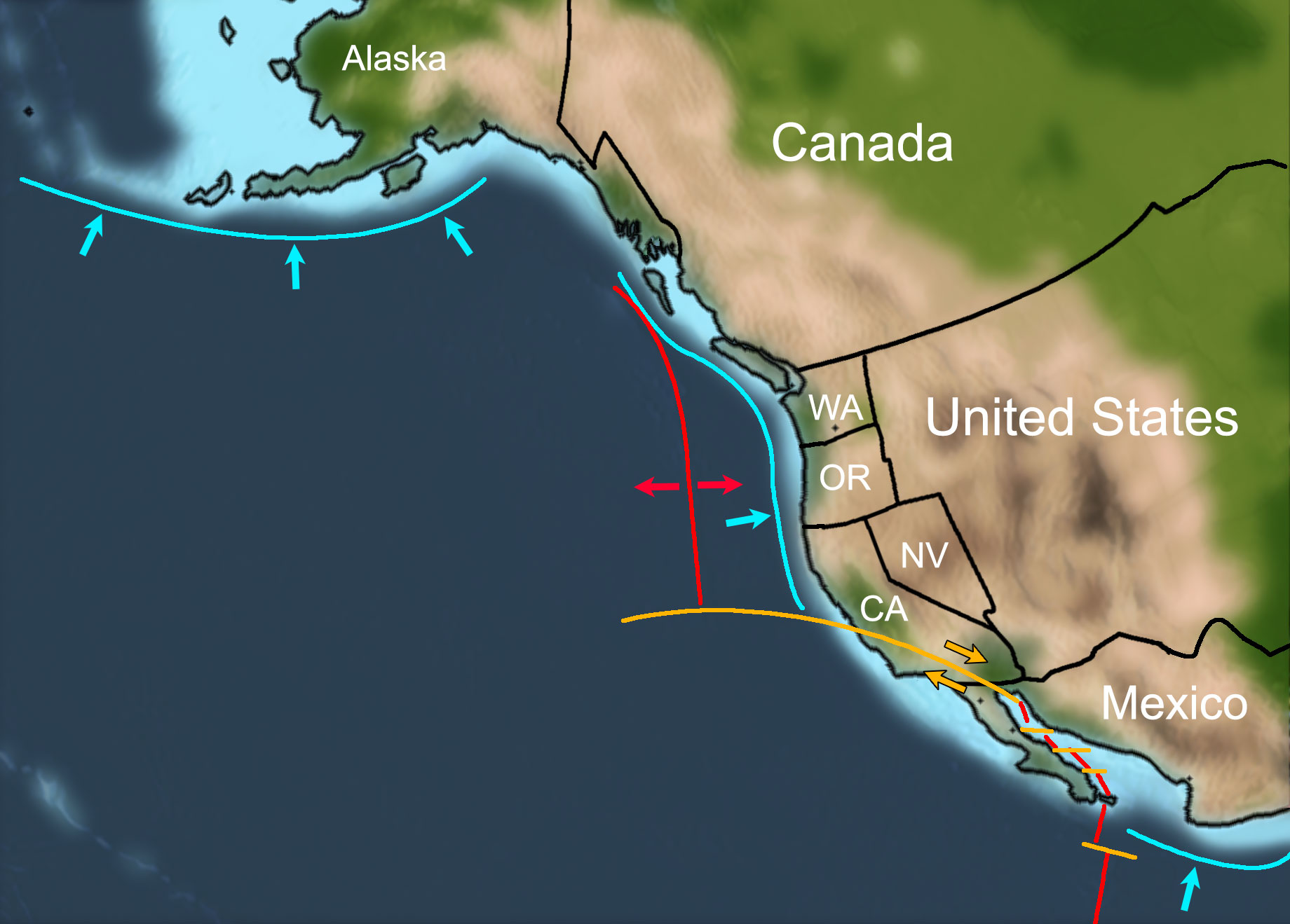
Modern plate boundaries of the West Coast of North America. Abbreviatons: CA = California, NV = Nevada, OR = Oregon, WA = Washington. Map by Frank Granshaw, originally published in the Teacher-Friendly Guide to the Earth Science of the Western US and modified for Earth@Home.
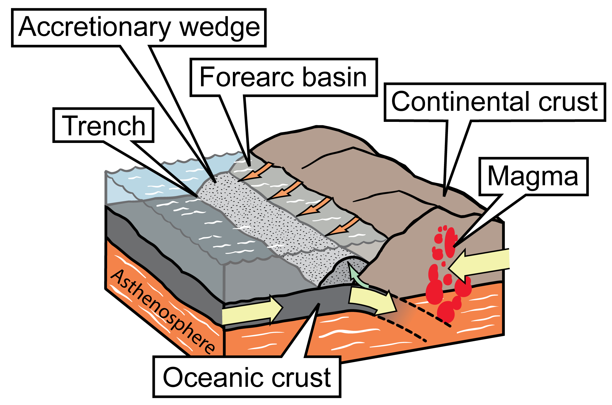
Simplified diagram of a subduction zone. The denser oceanic crust is subducted, or forced under, the more buoyant continental crust. The oceanic crust melts as it is subducted, and an accretionary wedge forms where the oceanic plate is scraped against the continental crust; in front of the wedge is a trench, and behind it is a forearc basin. Subduction of the oceanic crust produces magma, which wells up, causing volcanic activity. Image modified for Earth@Home from original by Jim Houghton, first published in The Teacher-Friendly Guide series (CC BY-NC-SA 4.0 license).
The Olympic Mountains of western Washington. These mountains are part of an accretionary wedge association with the Cascadia subduction zone. Photo by David Herrera (flickr, Creative Commons Attribution 2.0 Generic license, image cropped and resized).
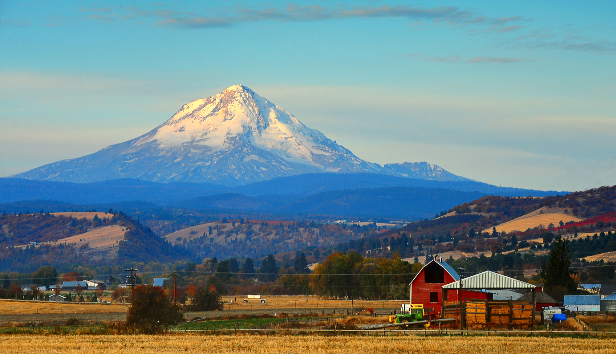
Mount Hood in Oregon is a stratovolcano in the Cascades. Source: U.S. Forest Service-Pacific Region (flickr, public domain).
Wrangell Mountains, Wrangell-St Elias National Park and Preserve, Alaska. NPS photo by Tom VandenBerg (Wrangell-St. Elias National Park and Preserve on flickr, Creative Commons Attribution-ShareAlike 2.0 Generic license, image cropped and resized).
A transform boundary in California
Although they are also located on an active margin, the crustal plates in central and southern California are moving sideways past one another rather than colliding. This transform boundary, which includes the San Andreas Fault, is a wide zone of north-south oriented faults with frequent and destructive earthquakes. Although volcanic activity is rare in this area, long, straight mountain ranges and troughs, such as Bodega Bay in northern California, are formed as blocks of crust are wrenched sideways.
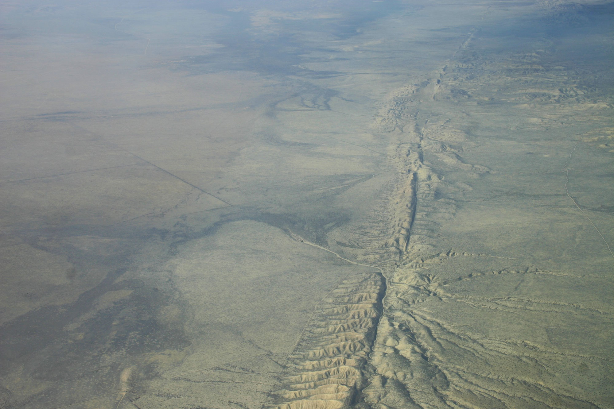
Aerial photo of the San Andreas Fault, Carrizo Plain, California. Photo by Ikluft (Wikimedia Commons, Creative Commons Attribution-ShareAlike 4.0 International license, image resized).
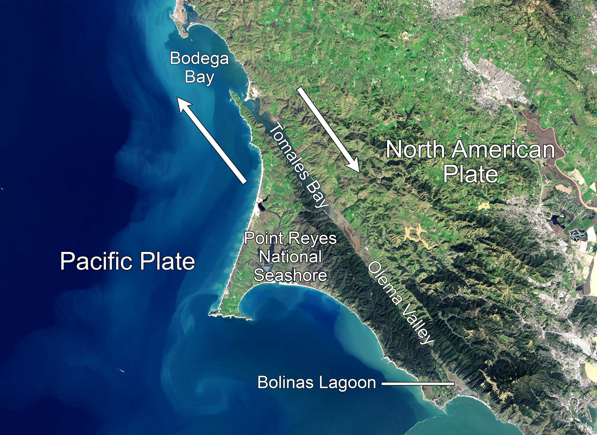
Aerial photo of the Central California coast in the area of Point Reyes and Bodega Bay, which are north of San Francisco. The San Andreas Fault is clearly visible; it runs through the Olema Valley and Tomales Bay, continuing northwest through Bodega Bay. Source: NASA Earth Observatory image by Jesse Allen (NASA Earth Observatory, used following NASA's image use policy, image cropped and labels added).
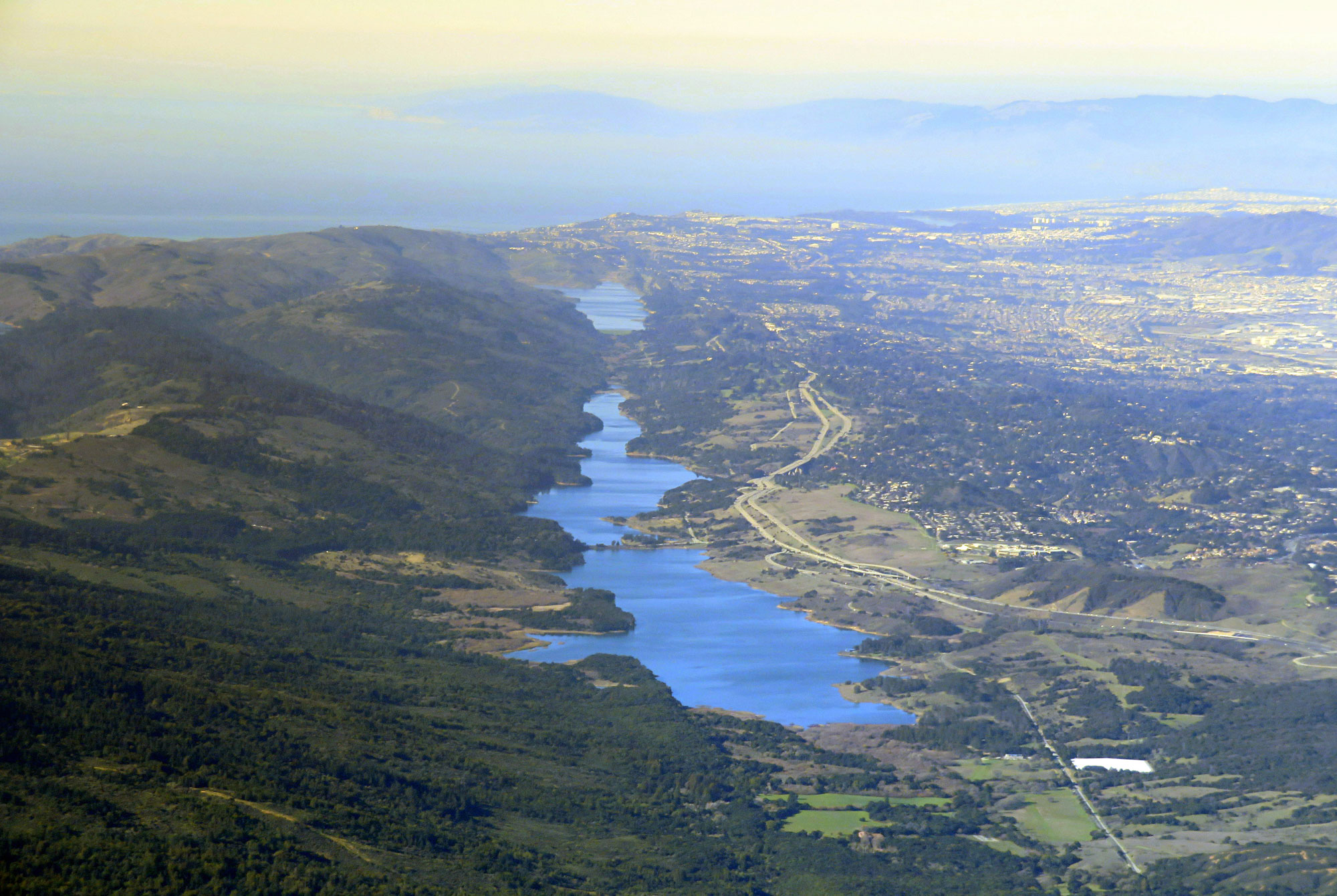
Crystal Springs Reservoir (foreground) and San Andreas Lake (background) on the San Andreas Fault, Central California coast, February 2018. Photo by Pi.1415926535 (Wikimedia Commons, Creative Commons Attribution-ShareAlike 3.0 Unported license, image cropped and resized).
Precambrian and Paleozoic (4.6 billion to 252 million years ago)
Neoproterozoic (1 billion to 541 million years ago)
Over 600 million years ago, the entirety of what is now the western states was either underwater or had not yet become part of North America (at that time called Laurentia). Seafloor sedimentary rocks found in the Klamath Mountains of Oregon and California, the Sierra Nevada mountains in California and Nevada and the Basin and Range region and northern Alaska indicate that the entire region was underwater. The coastline of ancient North America was to the east, near Arizona, Utah, and Idaho.
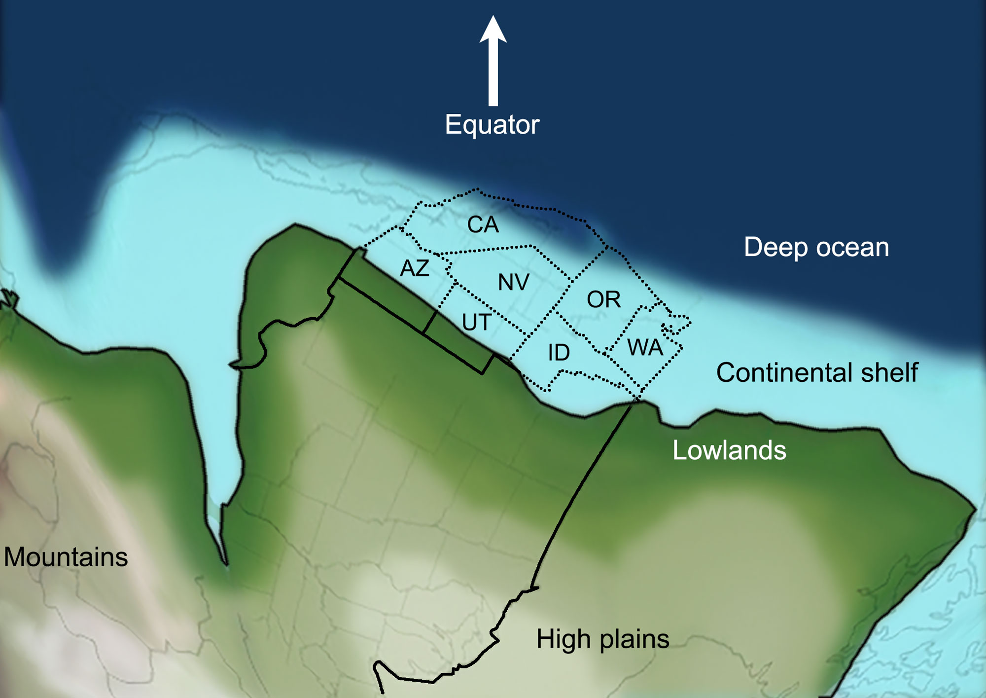
Western North America about 600 million years ago. Abbreviatons: AZ = Arizona, CA = California, ID = Idaho, NV = Nevada, OR = Oregon, UT = Utah, WA = Washington. Map by Frank Granshaw, originally published in the Teacher-Friendly Guide to the Earth Science of the Western US and modified for Earth@Home.
Paleozoic (541 to 252 million years ago)
In the early Paleozoic, about 500 million years ago, what is now the west coast of North America was a passive margin like the East Coast is today. Little or no volcanic activity or earthquakes occurred. Large mountain ranges and plate boundaries were not present in the western states at that time. As the Earth’s continents began moving towards one another to eventually form the supercontinent Pangaea, the western states became an active subduction zone, uplifting new mountains. Subduction also led to accretion, adding volcanic islands and seafloor sediment to the edge of the continent. One such episode of subduction and accretion created much of the present-day basement rock in Nevada and southern Oregon. Other periods of accretion created the Okanogan Highlands in northeastern Washington and southern British Columbia, Canada, and sections of the Alaska Range.
Sinlahekin Valley, Okanogan Highlands, northeastern Washington. Photo by U.S. Forest Service-Pacific Northwest Region (public domain).
By 400 million years ago, large mountain ranges had risen in parts of Alaska and the Basin and Range region of Nevada and Oregon. As accretion continued over time, the coastline moved farther west. The landmass also began to rotate, moving the North American plate into a more modern orientation. Around 300 million years ago, the western States were part of the continental margin of the supercontinent Pangaea.
Earth 300 million years ago, during the end of the Carboniferous Period (Pennsylvanian). Reconstruction created using basemap from the PALEOMAP PaleoAtlas for GPlates and the PaleoData Plotter Program, PALEOMAP Project by C. R. Scotese (2016); map annotations by Jonathan R. Hendricks & Elizabeth J. Hermsen for PRI's Earth@Home project (CC BY-NC-SA 4.0 license).
Mesozoic (252 to 66 million years ago)
For much of the Mesozoic, large sections of the western states were underwater. Pangaea began splitting apart around 250 million years ago. As the supercontinent rifted apart, subduction, volcanism, and accretion in the western states accelerated, adding more land to the continental margin. Land did not build up continuously; accretion in these states delivered packages of rock known as accreted or exotic terranes. Each terrane consists of sedimentary rock made from former seafloor sediment, slabs of oceanic crust (ophiolites), the remains of volcanic islands, and, in some instances, shards of continental crust. The terrane is pressed against the edge of the continent in a process called docking. In general, accretion was accompanied by volcanism and orogenies (episodes of mountain building).
Western North America in the Early Cretaceous, about 135 million years ago. The terrane contains an island arc in the process of docking with the Western States. This arc will eventually become part of Alaska and British Columbia (western Canada). Abbreviatons: CA = California, NV = Nevada, OR = Oregon, WA = Washington. Map by Frank Granshaw, originally published in the Teacher-Friendly Guide to the Earth Science of the Western US and modified for Earth@Home.
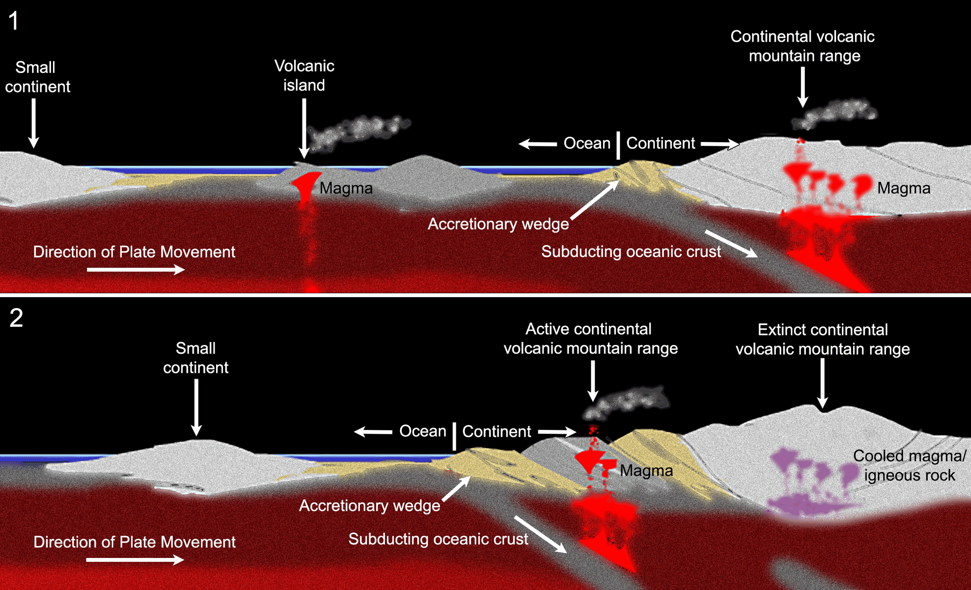
Idealized diagram showing the docking and accretion of a volcanic island at the edge of a continent. Upper diagram (1): A volcanic island (center) on oceanic crust moves toward the edge of a large continent (right). As the oceanic crust is subducted, an accretionary wedge forms at the edge of the continent and the melting oceanic crust in the subduction zone produces magma, which rises through the continental crust and forms a volcanic mountain range. Lower diagram (2): The volcanic island has docked on the edge of the continent. The active subduction zone has moved seaward, meaning that the original continental volcanic mountain range has gone extinct and an active continental volcanic mountain range has formed near the new subduction zone. The old accretionary wedge is sandwich between the extinct volcanic mountain range and the new active continental volcanic mountain range. A new accretionary wedge has formed at the active subduction zone. Image modified for Earth@Home from original by Frank Granshaw, first published in The Teacher-Friendly Guide to the Earth Science of the Western US (CC BY-NC-SA 4.0 license).
The Farallon Plate
When the supercontinent of Pangaea came together in the late Paleozoic Era, most of the world's continents were combined into the single landmass of Pangaea. Because of this, most of the world's seawater was found in a single ocean called the Panthalassic Ocean. The Panthalassic Ocean was essentially the ancient Pacific Ocean.
By the early Jurassic period, much of the floor of the Panthalassic Ocean was made up of three large plates: the Izanagi plate in the northwest, the Farallon Plate in the northeast, and the Phoenix Plate in the south. The modern Pacific Plate first formed by seafloor spreading at the junction between these plates about 190 million years ago. Over time, the Pacific Plate continued to grow by seafloor spreading. Meanwhile, the Farallon Plate shrank in area as it was subducted beneath the western margin of Pangaea (the western margin of the present-day Americas). In the Late Cretaceous, over 80 million years ago, the Farallon Plate split, with the northern part forming part of the Kula Plate and the southern Part continuing to be called the Farallon Plate.
The subduction of the Farallon and Kula plates played an important role in building mountains in North America during the Mesozoic and Cenozoic eras. Today, remnants of the Farallon Plate include the Juan de Fuca, Cocos, and Nazca plates that exist along the western margin of the Americas.
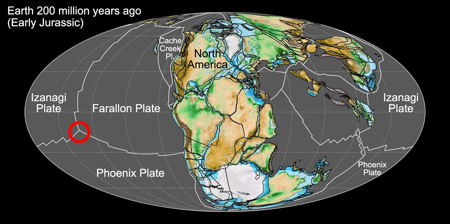
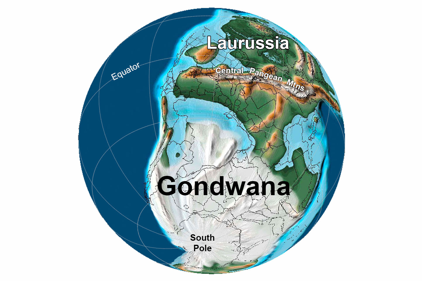
Earth 200 million years ago, showing Pangaea and the ancient Panthalassic Ocean (or the ancient Pacific). At this time, Earth's continents were combined into the supercontinent Pangaea. The floor of Panthalassa was largely made up of three plates, with the Farallon Plate bordering the western coast of ancient North America. The Pacific Plate, which makes up much of the floor of the modern Pacific ocean, originated at the junction between the Farallon, Izanagi, and Phoenix plates during the Jurassic Period (shown by the red circle on the map). Map by Fama Clamosa (Wikimedia Commons, Creative Commons Atribution-ShareAlike 4.0 International license, image cropped and labelled).
Nevadan, Sevier, and Laramide orogenies
Three Mesozoic mountain-building episodes were particularly important in the formation of the western United States. The Nevadan, Siever, and Laramide orogenies took place one after another from the Jurassic to the Paleogene, between about 180 and 50 million years ago. These orogenies were caused by the subduction of the Farallon Plate under the North American Plate.
During these events, subduction was occurring along the western margin of California. The topography and geology of the state thus reflect the features of a subduction zone. The California Coast Ranges formed as an accretionary wedge. In some places, mafic rocks (rocks rich in iron and magnesium) can be found in the Coast Ranges; these rocks came from ocean crust or the Earth's mantle. They were scraped off the subducting Farallon Plate and accreted to the edge of the overriding North American Plate, forming ophiolites. Serpentinite, the state rock of California, is a type of rock formed when ophiolite is metamorphosed.
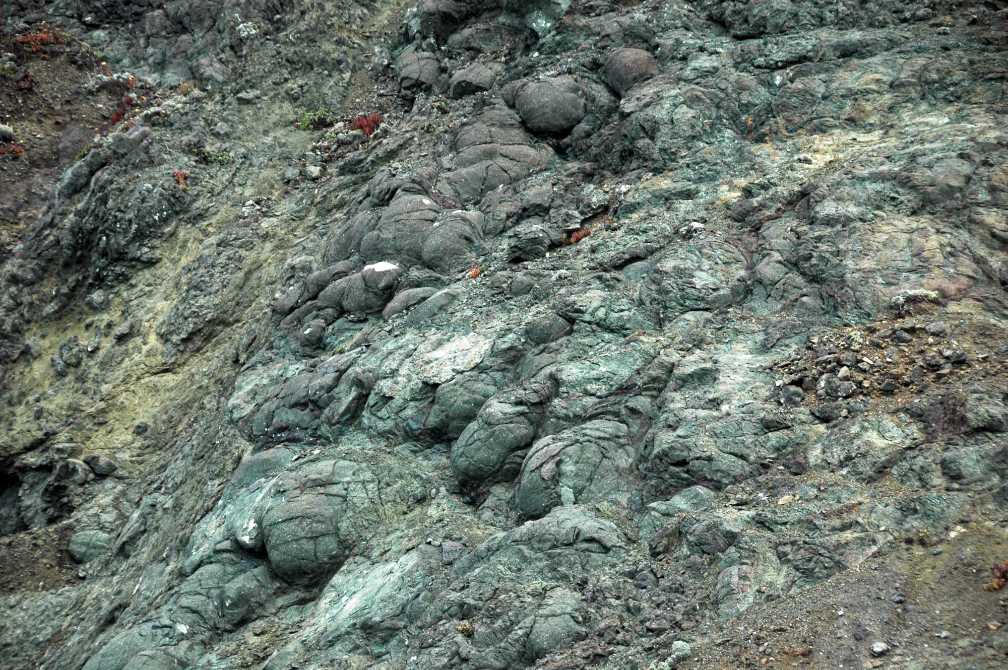
Metamorphosed pillow basalts, Point Bonita, Golden Gate National Recreation Area, California. Excerpt from original caption: "The bulbous, rounded masses of volcanic rock seen here are pillow basalts. The morphology is diagnostic of underwater lava eruptions. These rocks are part of the Franciscan Complex - they represent the top portion of Jurassic-aged oceanic crust. This basaltic crust originally formed at an ancient mid-ocean ridge and got plastered onto the edge of the North American continent along a now-inactive subduction zone." Photo and caption by James St. John (flickr, Creative Commons Attribution 2.0 Generic license).
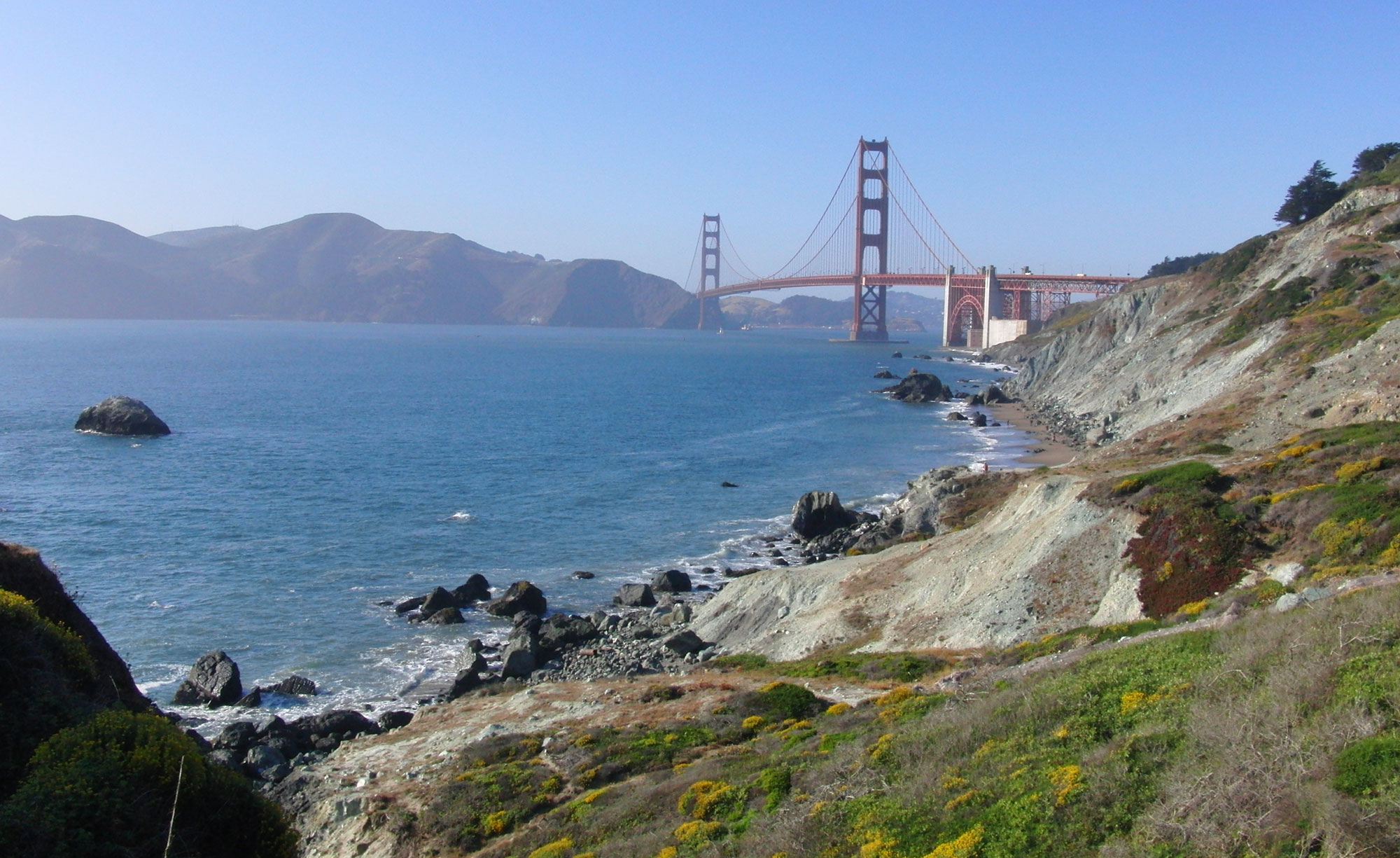
Serpentinite bluffs (greenish slopes, foreground) in the Presidio, a park in San Francisco, California, at one end of the Golden Gate Bridge (shown in the background), 2009. Photo by eric molia (flickr, Creative Commons Attribution 2.0 Generic license, image cropped and resized).
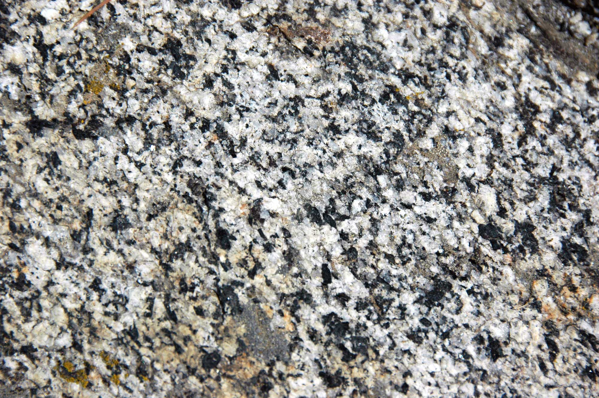
California's vast Central Valley separates the Coast Ranges and the Sierra Nevada mountains. The Central Valley was a forearc basin. Inland (to the east), subduction of the Farallon Plate produced magma. Magma is molten rock located below the surface of the Earth. When magma cools beneath the surface, it forms intrusive igneous rocks, like granite. The intrusive igneous rocks that make up much of the spectacular landscape of the Sierra Nevada mountains in places like Yosemite National Park are rocks that formed when magma cooled underground during the Cretaceous (these rocks were not uplifted and exposed until much later).
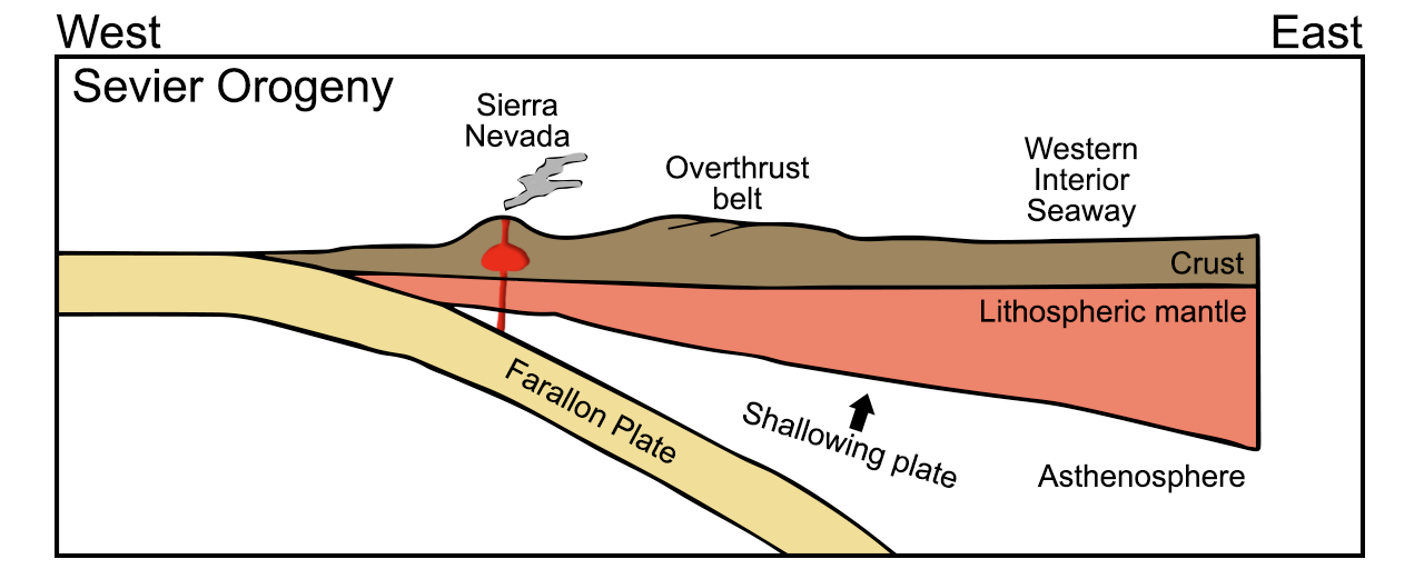
Diagram of the subduction of the Farallon plate during the Cretaceous Sevier Orogeny. The Wester Interior Seaway formed when the continental crust was downwarped in the central region of the North American continent. To the west, underground magma formed and the Sierra Nevada experienced volcanism. An overthrust belt occurred between the Sierra Nevada and the Western Interior Seaway. Diagram by Wade Greenberg-Brand, adapted from an image by the New Mexico Institute of Mining and Technology, originally published in the Teacher Friendly Guide to Earth Science series. Modified for Earth@Home.
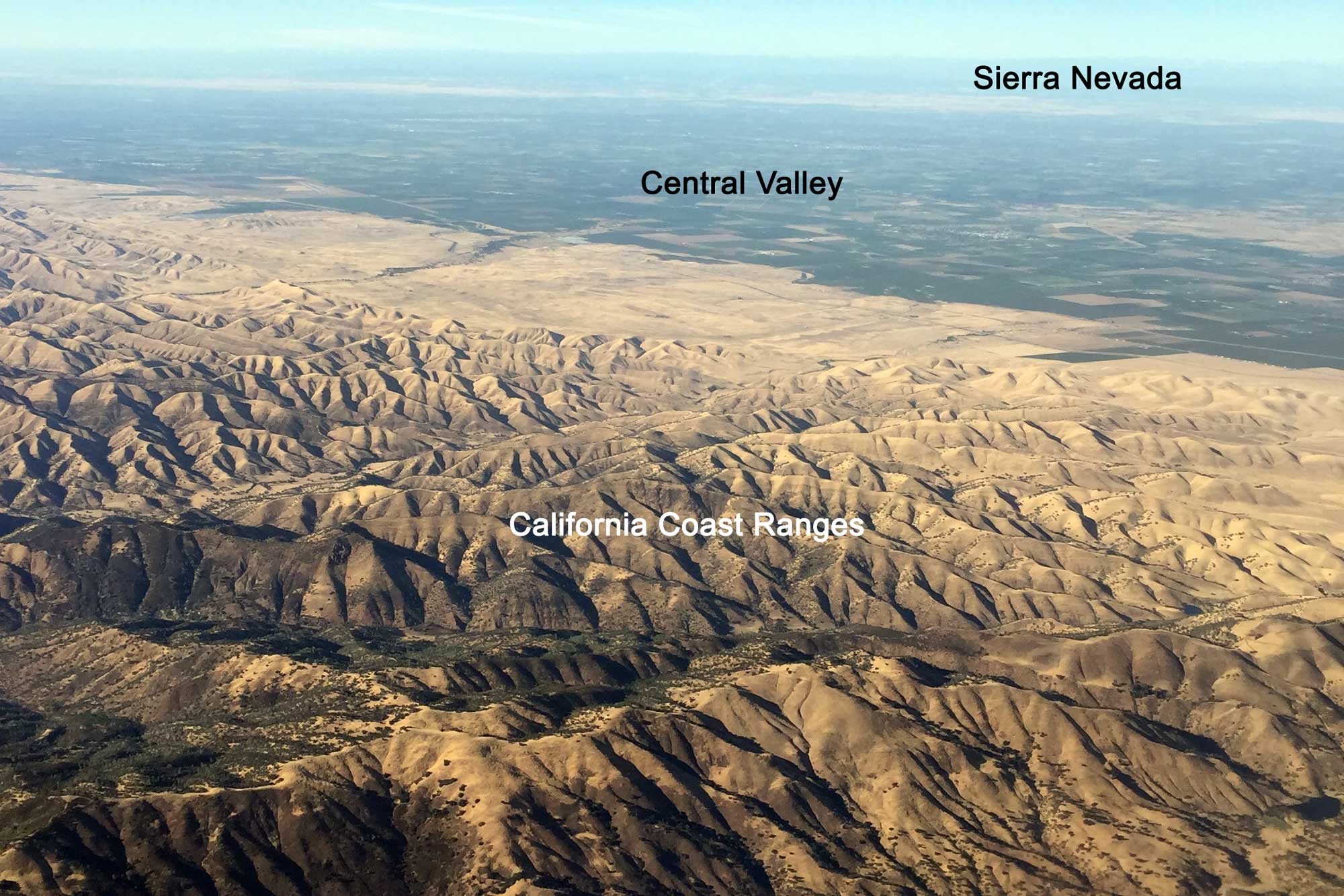
Aerial photograph of California's Central Valley and Coastal Ranges; the Sierra Nevada Mountains are visible in the background. The photograph is taken looking to the east. Photograph by Jonathan R. Hendricks.
Roche moutonnée, Yosemite National Park, eastern California. The Late Cretaceous Cathedral Peak Granite that makes up this formation is part of a Mesozoic batholith (a body of intrusive igneous rock that cooled underground) that makes up some of the rock in the Sierra Nevada mountains. Photo by James St. John (flickr, Creative Commons Attribution 2.0 Generic license, image resized).
Detail of the Late Cretaceous Giant Forest Granodiorite, Sequoia National Park, eastern California. The Late Cretaceous Giant Forest Granodiorite is part of a Mesozoic batholith (a body of intrusive igneous rock that cooled underground) that makes up some of the rock in the Sierra Nevada mountains. Photo by James St. John (flickr, Creative Commons Attribution 2.0 Generic license, image resized).
Western Interior Seaway
Sedimentary rock found in the Midwest indicates that shallow seas episodically inundated the interior of North America, turning major parts of the western states into a broad isthmus. The exact reasons for this periodic flooding are not known, but there are two possibilities: sea level rise or a change in the elevation of the continental plain. Although sea level change is often associated with climate change, it can also be driven by changes in the bathymetry (topography) of the ocean floor. Increased volcanic activity at mid-ocean ridges could have increased the size of the ridges, displacing seawater and causing the sea level to rise. Additionally, as Pangaea began to drift apart, the crust underlying the Interior Plains most likely stretched, causing it to thin and making the land surface drop below sea level.
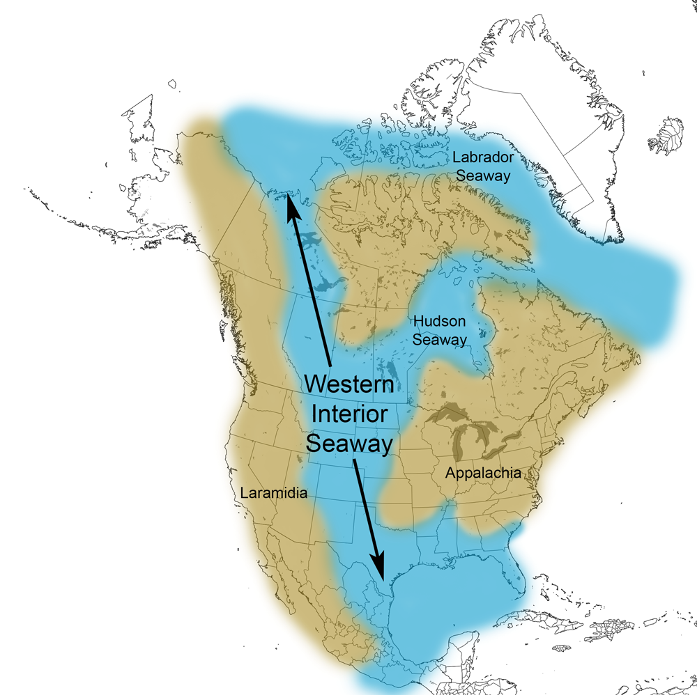
Extent of the Western Interior Seaway during the Cretaceous Period. Image from Cretaceous Atlas of Ancient Life: Western Interior Seaway (Creative Commons Attribution-NonCommercial-ShareAlike 4.0 International license).
Cenozoic (66 million years ago to present)
The geography of the Western States became progressively more recognizable during the Cenozoic. Around 66 million years ago, the entire west coast of North America was a convergent boundary, where subduction created volcanic mountain ranges. Accretion of terranes also continued.
All of the earliest volcanic mountain ranges have ceased to erupt, often being replaced by newer ranges farther westward. As more land accreted to the edge of the continent, subduction became increasingly more difficult, until it finally stopped and a new subduction zone was formed farther seaward. When this happened, the source of magma for the old volcanic arcs was cut off, and a new arc formed closer to the new boundary. This accretion caused the western edge of North America to expand further westward towards its present configuration.
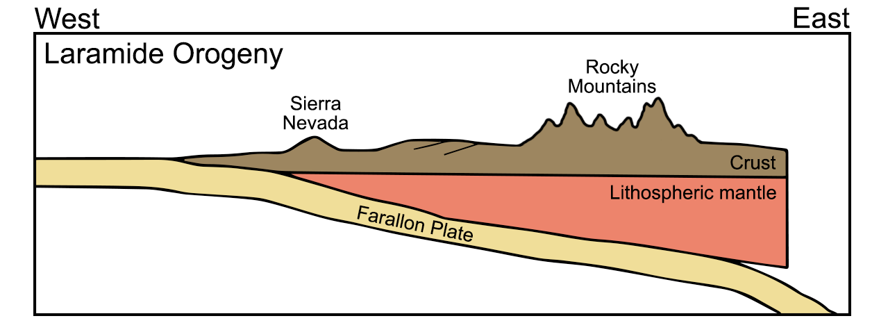
Diagram of the subduction of the Farallon plate during the Late Cretaceous to Paleogene Laramide Orogeny. During this orogeny, the Western Interior Seaway closed and the Rocky Mountains were uplifted. The Sierra Nevada was no longer volcanically active. Diagram by Wade Greenberg-Brand, adapted from an image by the New Mexico Institute of Mining and Technology, originally published in the Teacher Friendly Guide to Earth Science series. Modified for Earth@Home.
Southern and Central California and Basin and Range
San Andreas Fault
A major change in the plate boundary along California also contributed to the extinction of the older Cenozoic volcanic arcs. Beginning about 30 million years ago, a mid-ocean ridge called the East Pacific Rise collided with the North American continent. As this ridge subducted, the plate boundary adjacent to California gradually changed, becoming a transform or sideways-moving boundary. As a result, subduction ceased, as did the last of the volcanic activity in what we now know as the Sierra Nevada in eastern California and western Nevada.
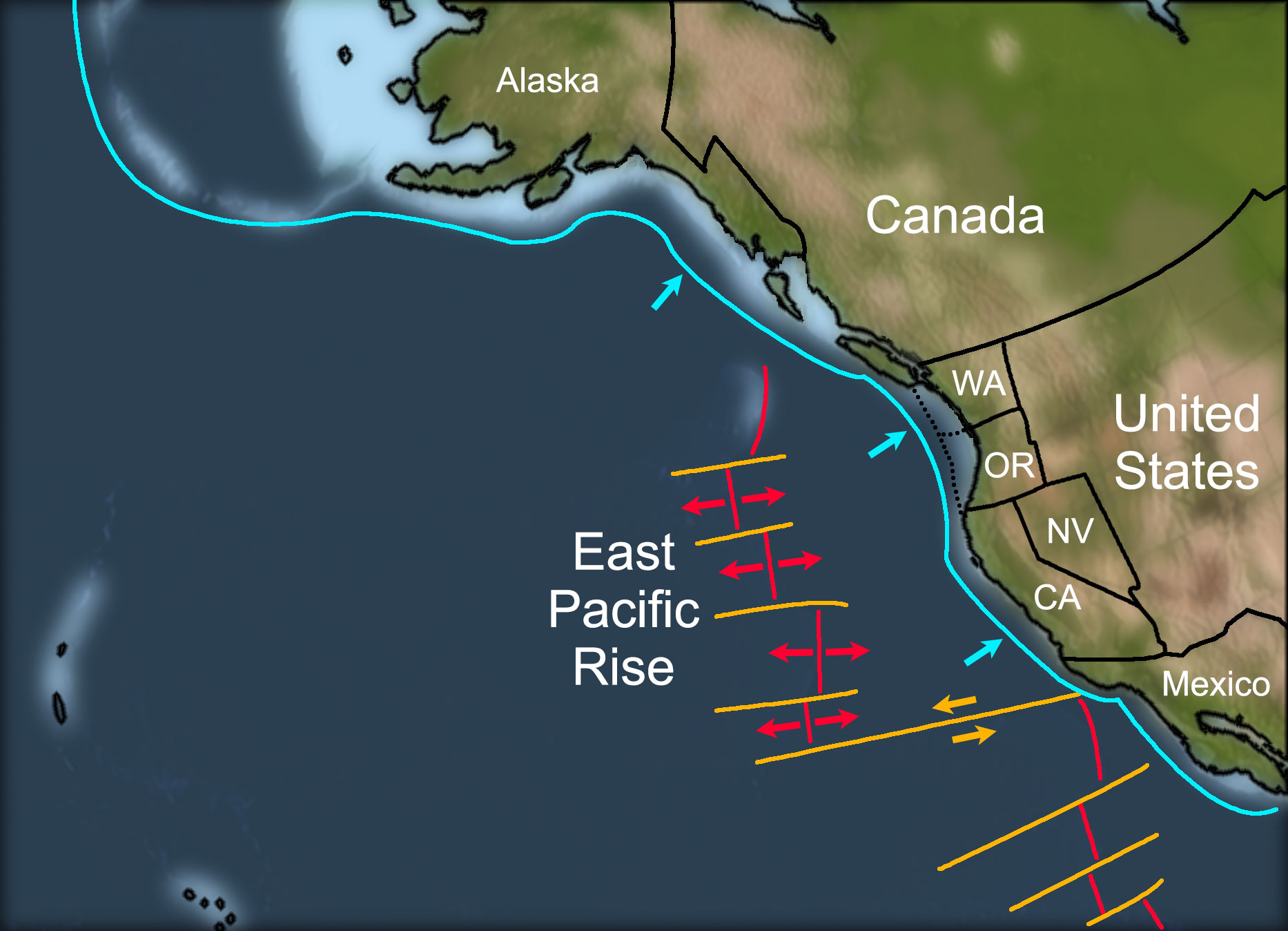
Western North America about 30 million years ago. Abbreviatons: CA = California, NV = Nevada, OR = Oregon, WA = Washington. Map by Frank Granshaw, originally published in the Teacher-Friendly Guide to the Earth Science of theWestern US and modified for Earth@Home.
Western North America about 5 million years ago. Abbreviatons: CA = California, NV = Nevada, OR = Oregon, WA = Washington. Map by Frank Granshaw, originally published in the Teacher-Friendly Guide to the Earth Science of the Western US and modified for Earth@Home.
Basin and Range
By the Neogene, the Farallon plate lay shallowly under the North American plate for hundreds of kilometers eastward of the West Coast. Now situated more fully beneath what are now parts of the south-central, southwestern, western, and northwest-central states, this extra layer of crust caused uplift and extension of the region, as the added thickness of buoyant rock (relative to the mantle) caused the entire area to rise isostatically. The Farallon plate was subjected to increasing temperatures as it subducted, causing it to expand. As heat dissipated to the overlying North American plate, that rock expanded as well. Finally, the high temperatures in the upper mantle caused the Farallon plate to melt, and the resulting magma was injected into the North American plate, destabilizing it.
These processes, along with the complex crustal movements taking place along the San Andreas fault, caused the surface of the North American plate to pull apart and fault into the north-south trending mountainous blocks and valleys of the huge Basin and Range province. This province covers part of eastern California, most of Nevada, and southern Oregon, as well as parts of other states stretching from Idaho and Utah into Arizona, New Mexico, and Texas.
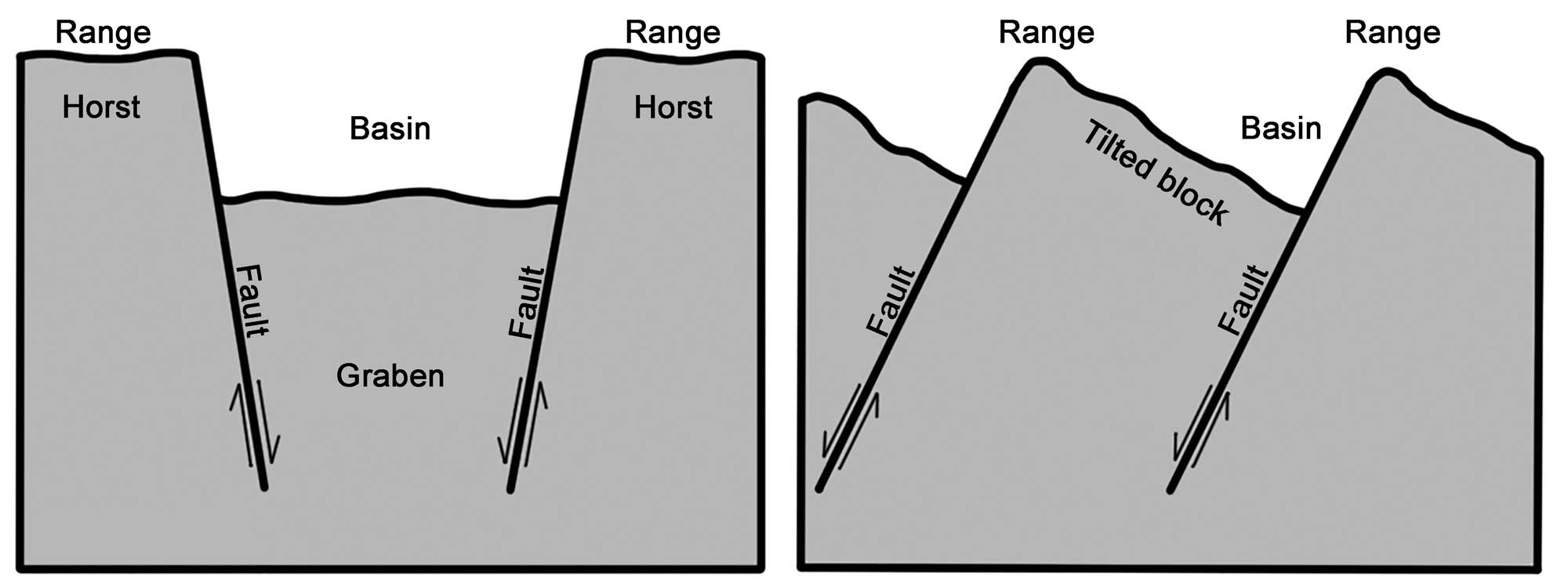
Formation of the Basin and Range. Alternating basins and ranges were formed during the past 17 million years by gradual movement along faults. Arrows indicate the relative movement of rocks on either side of a fault. Image modified from original by Wade Greenberg-Brand, in turn adapted from an image by the USGS (public domain).
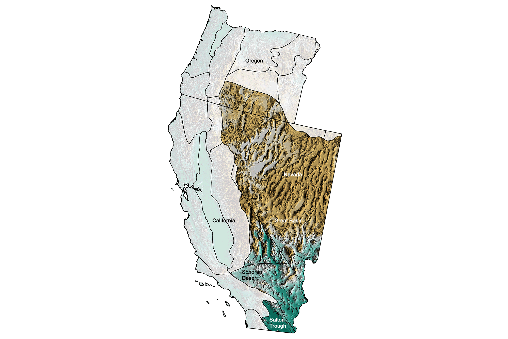
Physiographic subdivisions of the Basin and Range region of the western United States. Greens indicate lower elevation, browns higher elevation; black lines indicate state boundaries or boundaries of other physiographic provinces. Topographic data derived from the Shuttle Radar Topography Mission (SRTM GL3) Global 90m (SRTM_GL3) (Farr, T. G., and M. Kobrick, 2000, Shuttle Radar Topography Mission produces a wealth of data. Eos Trans. AGU, 81:583-583.). Image created by Jonathan R. Hendricks for the Earth@Home project.
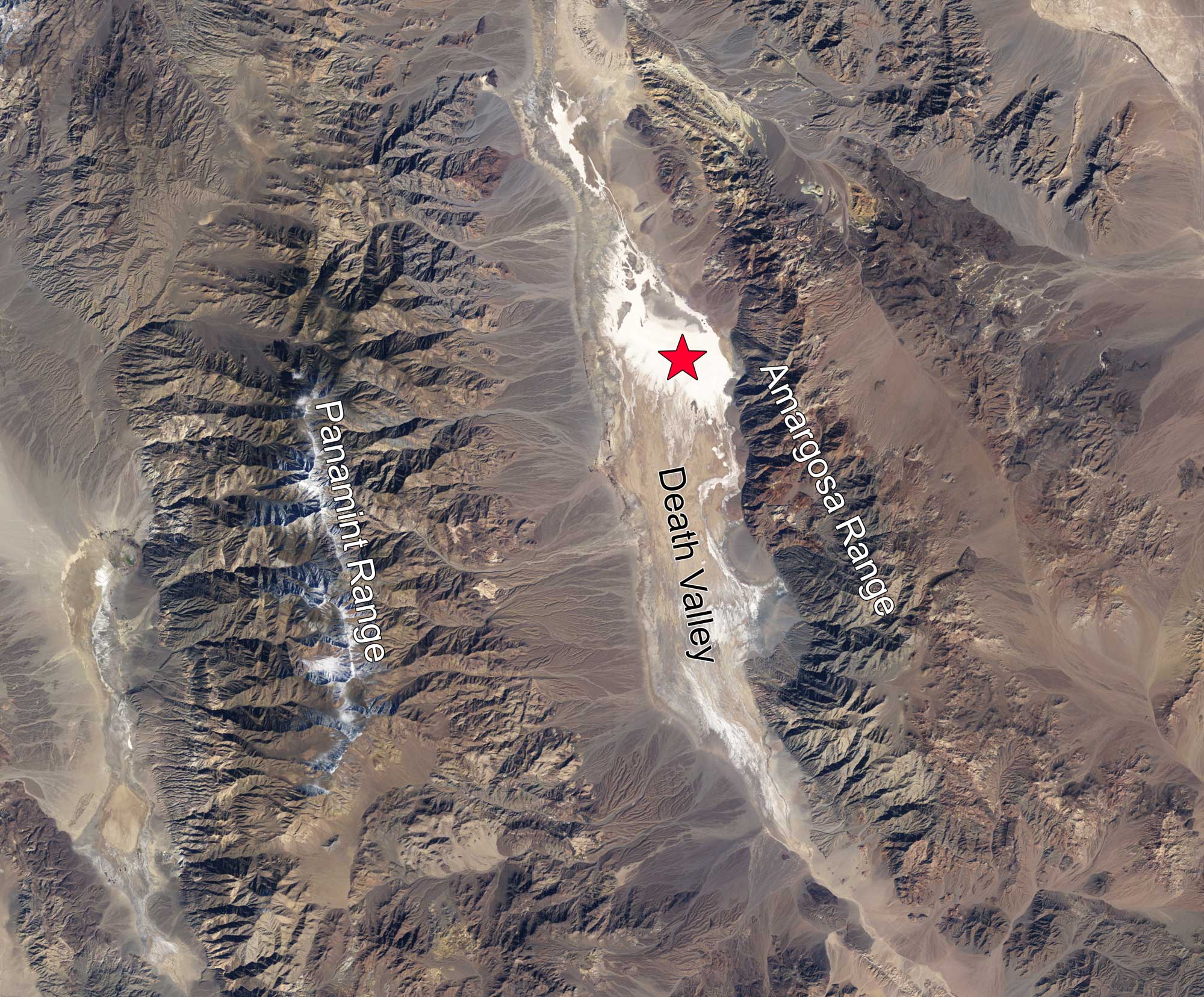
Satellite image of Death Valley in the Basin and Range province, eastern California. The Badwater Basin in Death Valley (marked with a red star) is at the lowest elevation in North America at 86 meters (282 feet) below sea level. Photo by Robert Simmons, based on Landsat data from the USGS Global Visualization Viewer (NASA Earth Observatory, used following NASA's image use policy, image cropped and labels added).
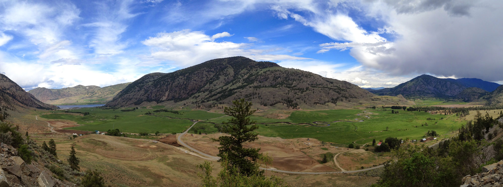
Worthington Mountains, Worthington Mountains Wilderness, Nevada. Photo by BLM Nevada on flickr (Creative Commons Attribution 2.0 Generic license, image cropped and resized).
Sierra Nevada mountains
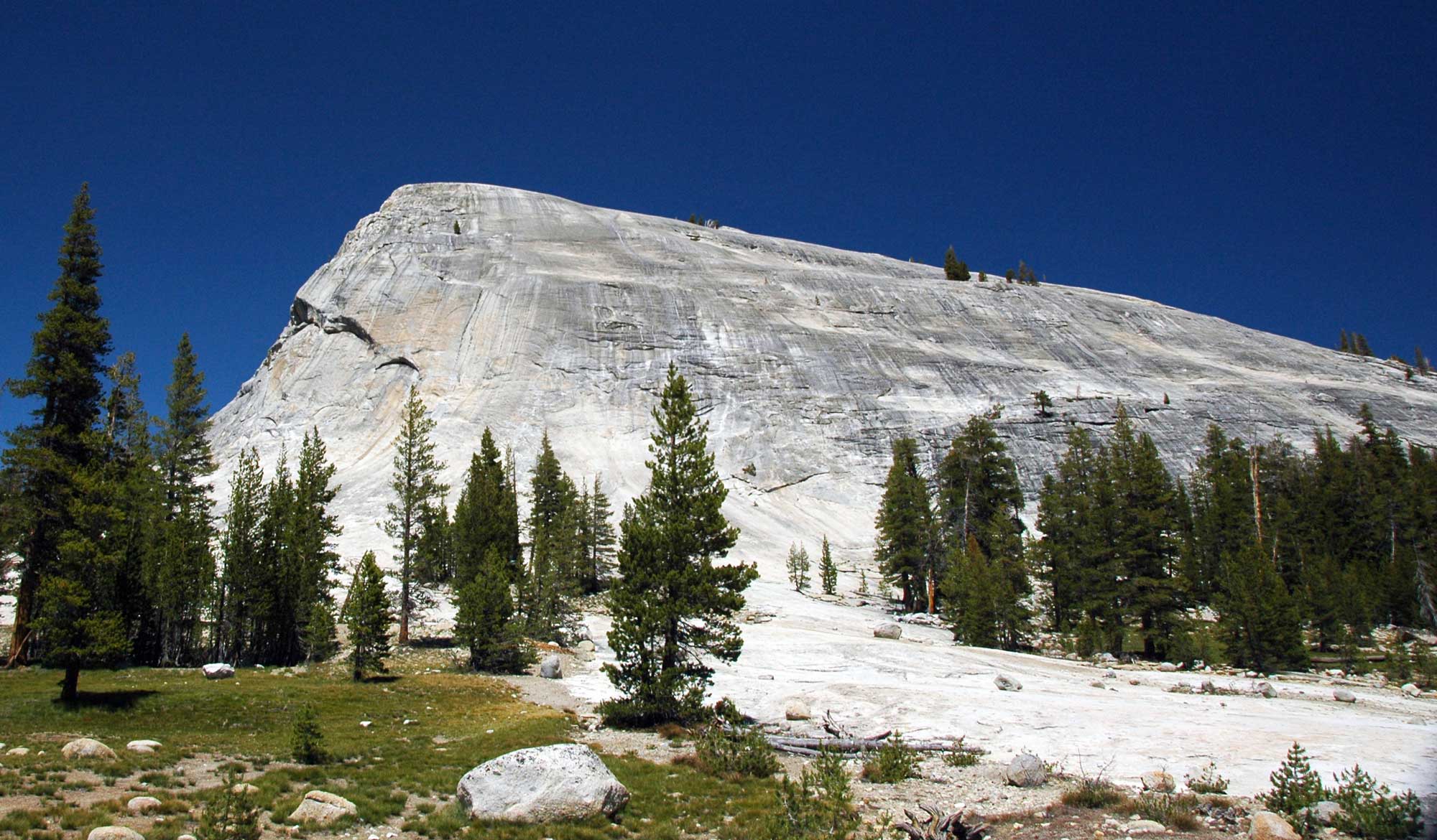
Much of the present-day Sierra Nevada is a large exposure of granite called a batholith. A batholith is the remains of the magma chambers that previously fueled volcanic mountain ranges that are exposed once the ancestral ranges have been eroded away. In the case of the Sierra Nevada, the stretching of the Basin and Range uplifted the solidified magma chambers of the ancestral range as rivers, landslides, and glaciers eroded away the overlying rock. The continued erosion of this rock is the source of much of the gold-laden gravel found in the rivers of California’s Central Valley.
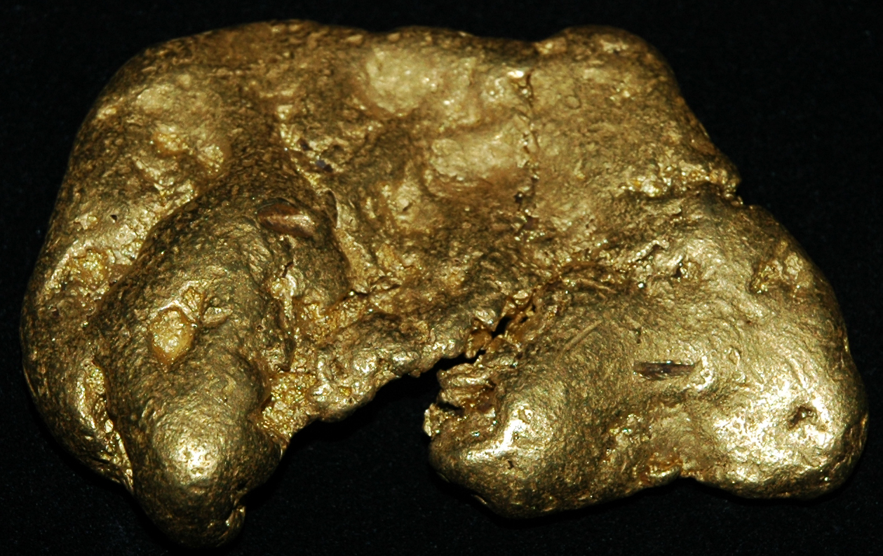
Nugget of placer gold (gold from a stream deposit) found in California. Specimen on display at the Carnegie Museum of Natural History, Pittsburgh, Pennsylvania. Photo by James St. John (flickr, Creative Commons Attribution 2.0 Generic license, image resized).
Northern California, Oregon, and Washington
Cascadia subduction zone
Like the mountain ranges further south in California, the mountain ranges found from southern British Columbia, Canada, to northern California reflect the standard features of a subduction zone. The Coast Ranges and the Olympic Mountains are part of an accretionary wedge; the Willamette Valley and Puget Sound are parts of a forearc basin; and the Cascades are inland volcanoes.
In the early Cenozoic, the Farallon plate was being subducted beneath the North American plate in this region. As this plate continued to subduct, in broke into smaller plates, which were each given their own names. Today, the plate being subducted under the North American plate in the region spanning southern British Columbia to northern California is called the Juan de Fuca plate (sometimes itself considered three small plates: the Explorer, Juan de Fuca, and Gorda plates).
In the Paleogene, a terrane called Siletzia docked on the edge of the North American continent, creating southern Vancouver Island as well as the western parts of Oregon and Washington. The present-day Cascade Range is made up of a series of volcanoes that have built up a large platform of volcanic debris. These volcanoes, the Cascade Volcanic Arc, began to arise 36 million years ago (in the late Eocene). However, the major volcanic peaks that make up the High Cascades formed more recently, within the Pleistocene.
Active subduction still occurs off the west coast of northern California, Oregon, Washington, and southern British Columbia. As long as subduction continues, the Cascades will remain volcanically active; there is evidence that the rate of subduction is slowing, and, as a result, volcanism in the Cascades will eventually cease.
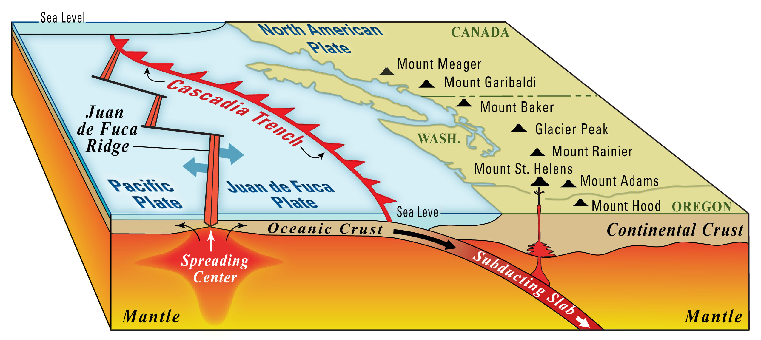
Diagram of the northern portion of the Cascadia Subduction Zone. Source: USGS.
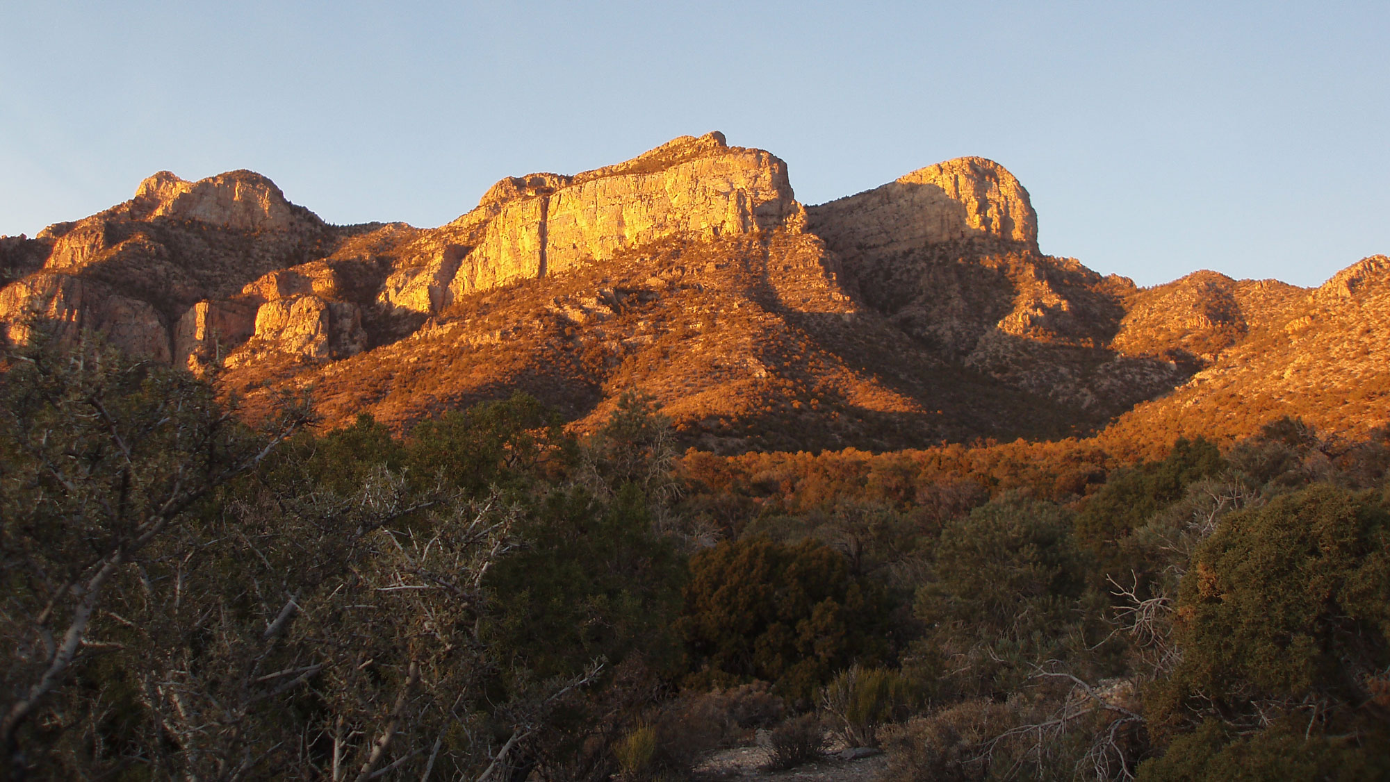
Northern Oregon Coast Range. Photo by Walter Siegmund (Wikimedia Commons, Creative Attribution-Share Alike Unported license, image resized).
Northwestern slope of Mount Rainier, photographed from an airplane. Photograph by Caleb Riston (Wikimedia Commons; Creative Commons Attribution 4.0 International license; image cropped and resized).
Yellowstone hotspot and Columbia River Basalts
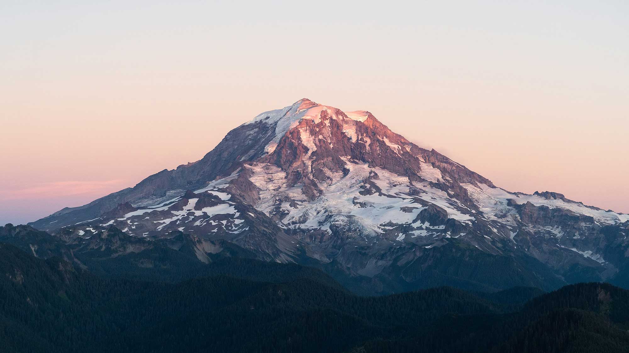
During the Miocene (about 17 to 14 million years ago), the Columbia River Basalts erupted. These massive basalt flows may have been caused by the formation of the Yellowstone hotspot beneath the North American Plate. They blanketed parts of southeastern Washington, northern and eastern Oregon, western Idaho, and a bit of northern Nevada in thick layers of basalt. Volcanics more clearly formed by the Yellowstone hotspot are found in the Miocene McDermitt and Owyhee-Humboldt volcanic fields of the southern Oregon-northern Nevada border. (Due to drift of the North American plate over the Yellowstone hotspot, the hotspot currently sits beneath Yellowstone National Park in Wyoming).
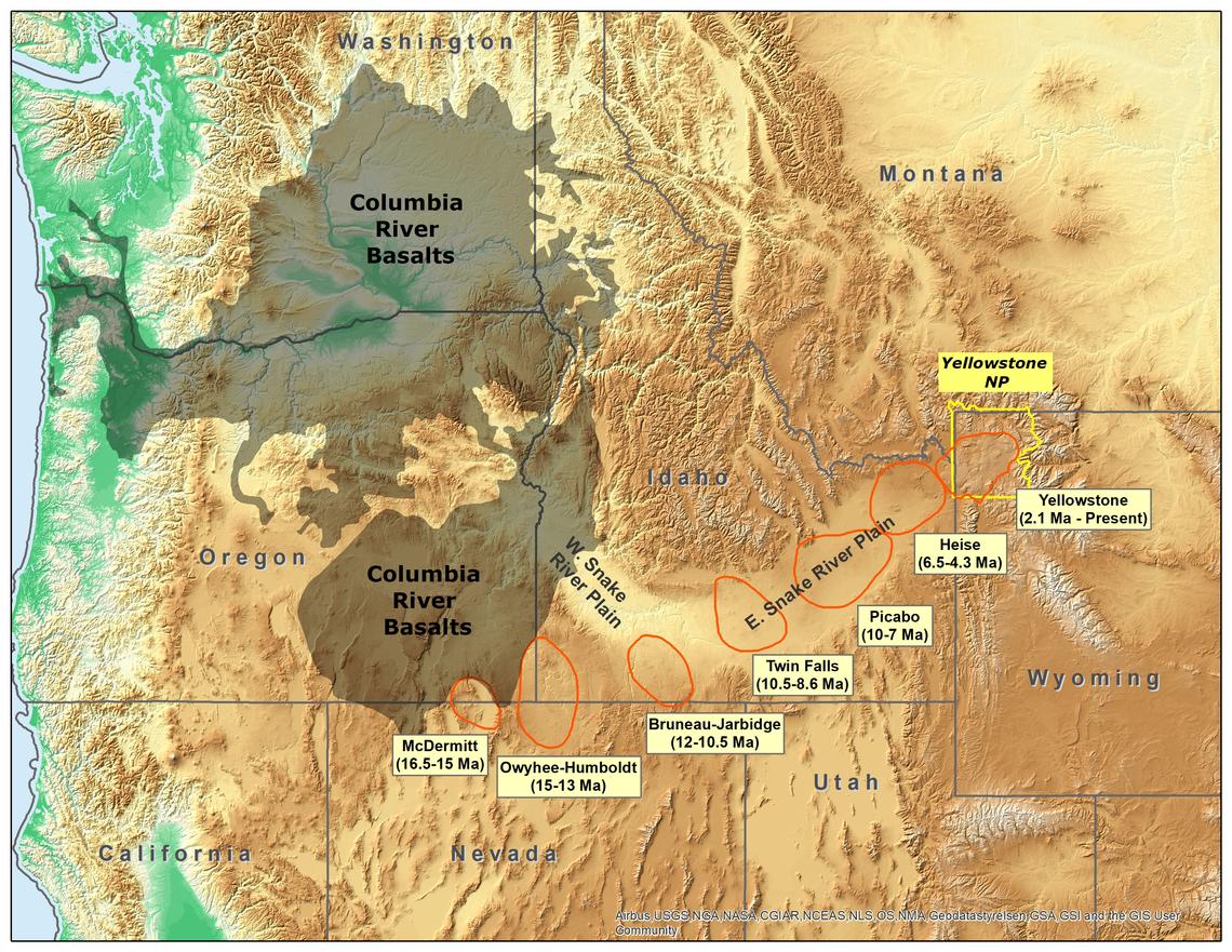
Original caption: "Map of the northwestern U.S., showing the approximate locations of Yellowstone hotspot volcanic fields (orange) and Columbia River Basalts (gray). Boundary of Yellowstone National Park is shown in yellow. Modified from Barry et al. (GSA Special Paper 497, p. 45-66, 2013), Smith and Siegel (Windows into the Earth: the geologic story of Yellowstone and Grand Teton National Parks: Oxford University Press, 2000), and Christiansen (USGS Professional Paper 729-G, 2001)." Source: USGS (public domain).
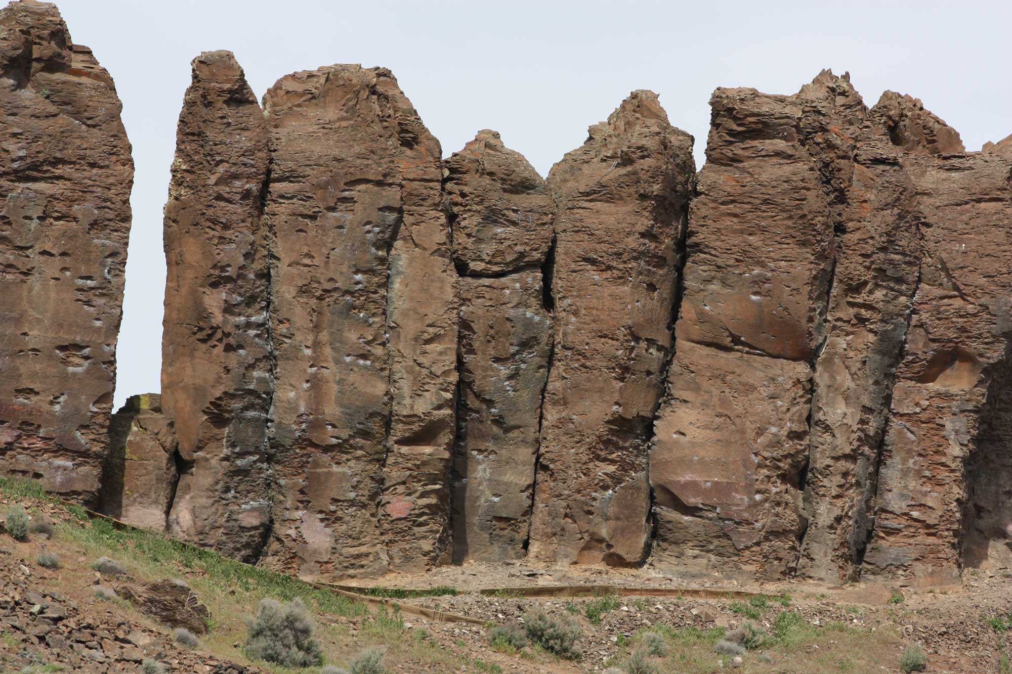
Columbia River Basalt on French Coulee, Washington. Photo by Walter Siegmund (Wikimedia Commons, Creative Commons Attribution-ShareAlike 3.0 Unported license, image resized).
Alaska
Subduction has occurred along the southern coastline of Alaska throughout the Cenozoic. The Aleutian Islands are a chain of islands that occur where an oceanic plate, the Pacific Plate, is being subducted beneath the North American plate. The islands themselves are volcanoes that have formed on the overriding North American plate, similar to the Cascade volcanoes. The Alaska Peninsula and the southern coastline of Alaska also experience volcanism related to subduction. In Alaska, accretion and volcanism continue to add more land to the coastline. Currently, the Yakutat terrane is accreting to the southeastern coast of Alaska near the Alaska-Yukon (Canada) border.
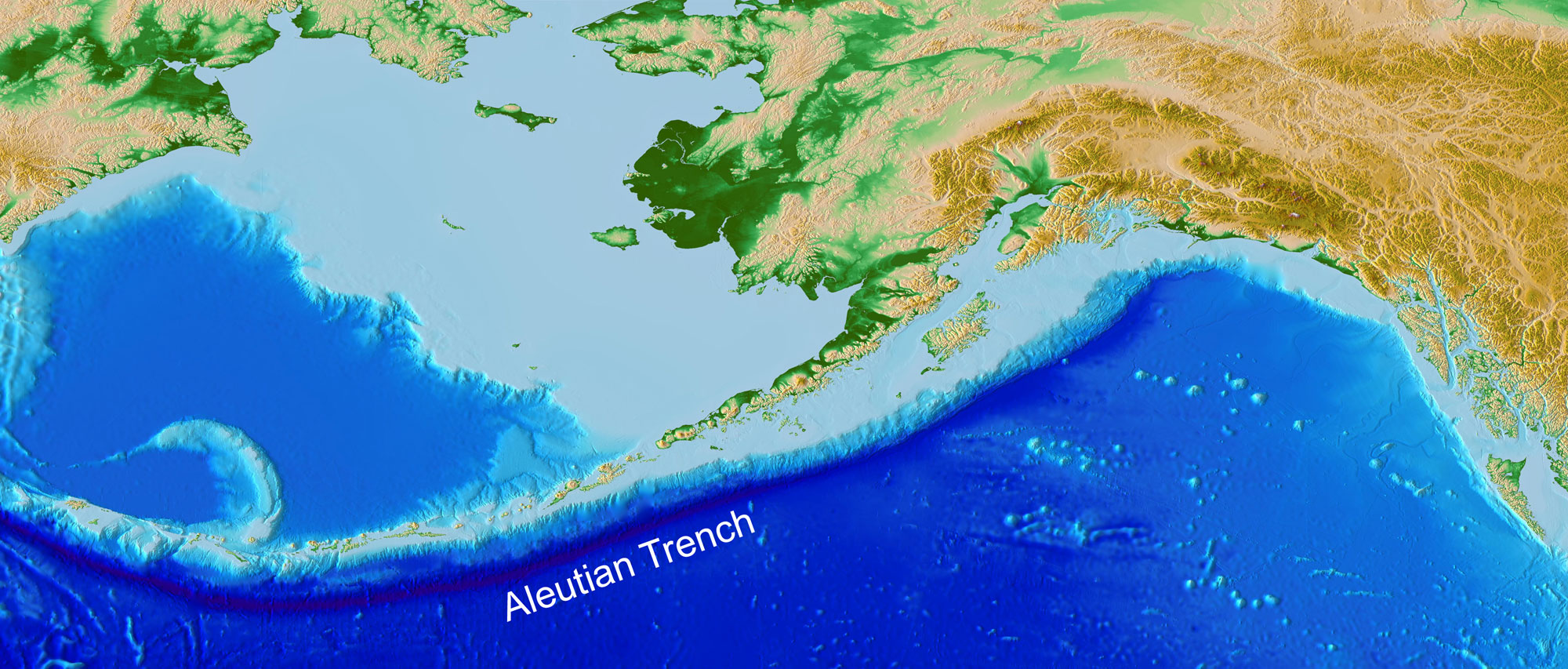
Coastal relief map of southern Alaska. The subduction trench on the border of the Aleutian volcanic island arc is clearly visible as a curving, dark blue line. The trench parallels the southern edge of the Aleutian Island chain and diverges slightly seaward as it approaches mainland Alaska (top center of the image). Source: NOAA (Lim, E., B.W. Eakins, and R. Wigley, Coastal Relief Model of Southern Alaska: Procedures, Data Sources and Analysis, NOAA Technical Memorandum NESDIS NGDC-43, 22 pp., August 2011).
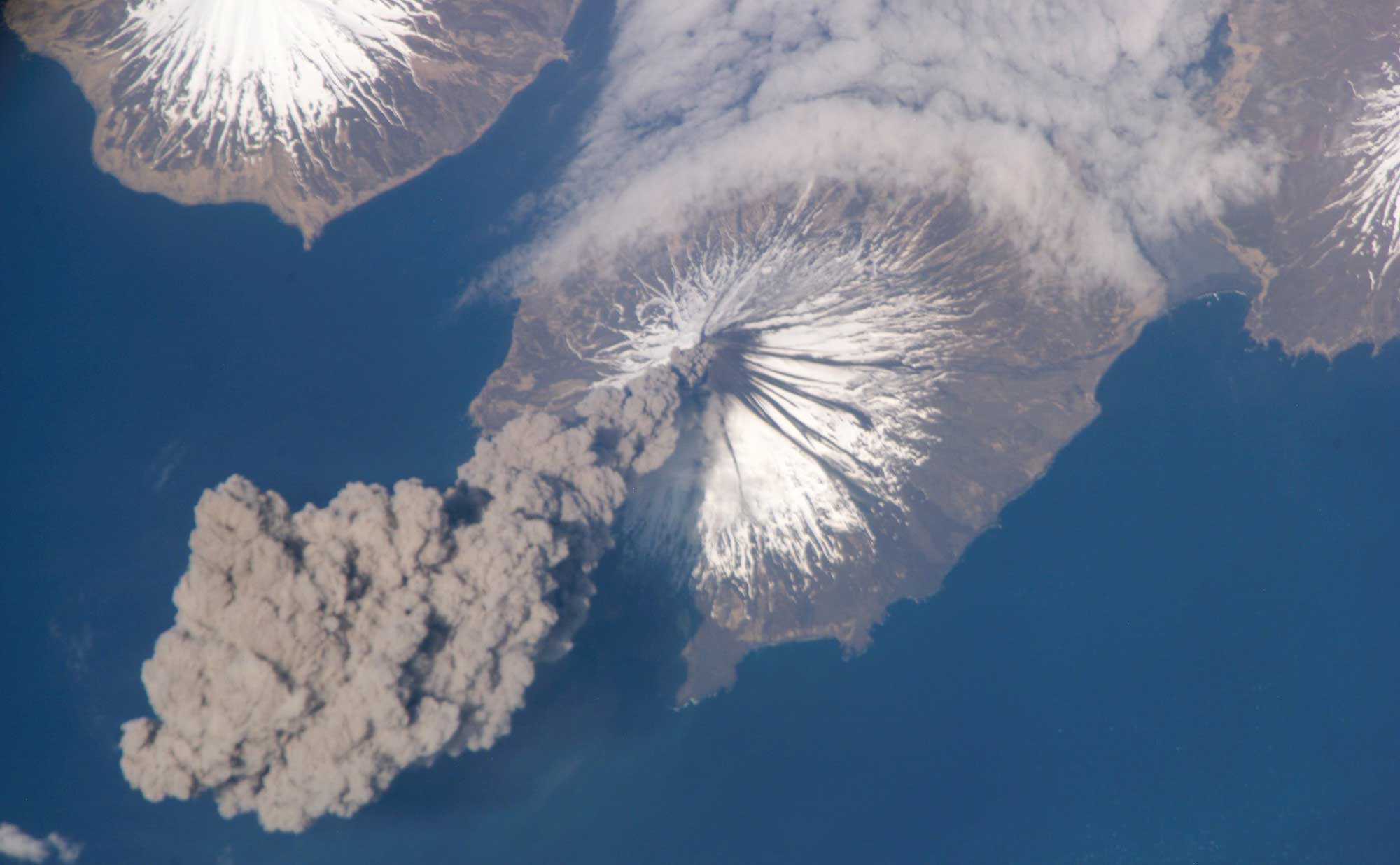
Satellite photograph of the eruption of Cleveland Volcano in the Aleutian Islands of Alaska. Image by NASA (Flickr; Creative Commons Attribution-NonCommercial 2.0 Generic license).
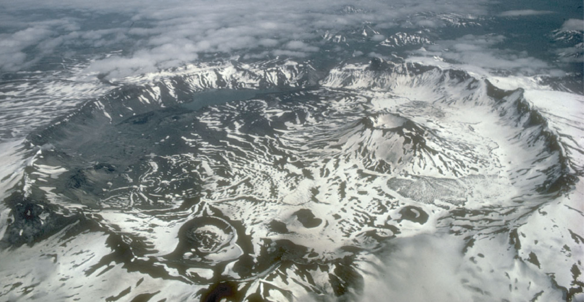
Aerial photo of Aniakchak caldera, Aniakchak National Monument and Preserve, Alaska Peninsula. Photo: National Park Service (public domain).
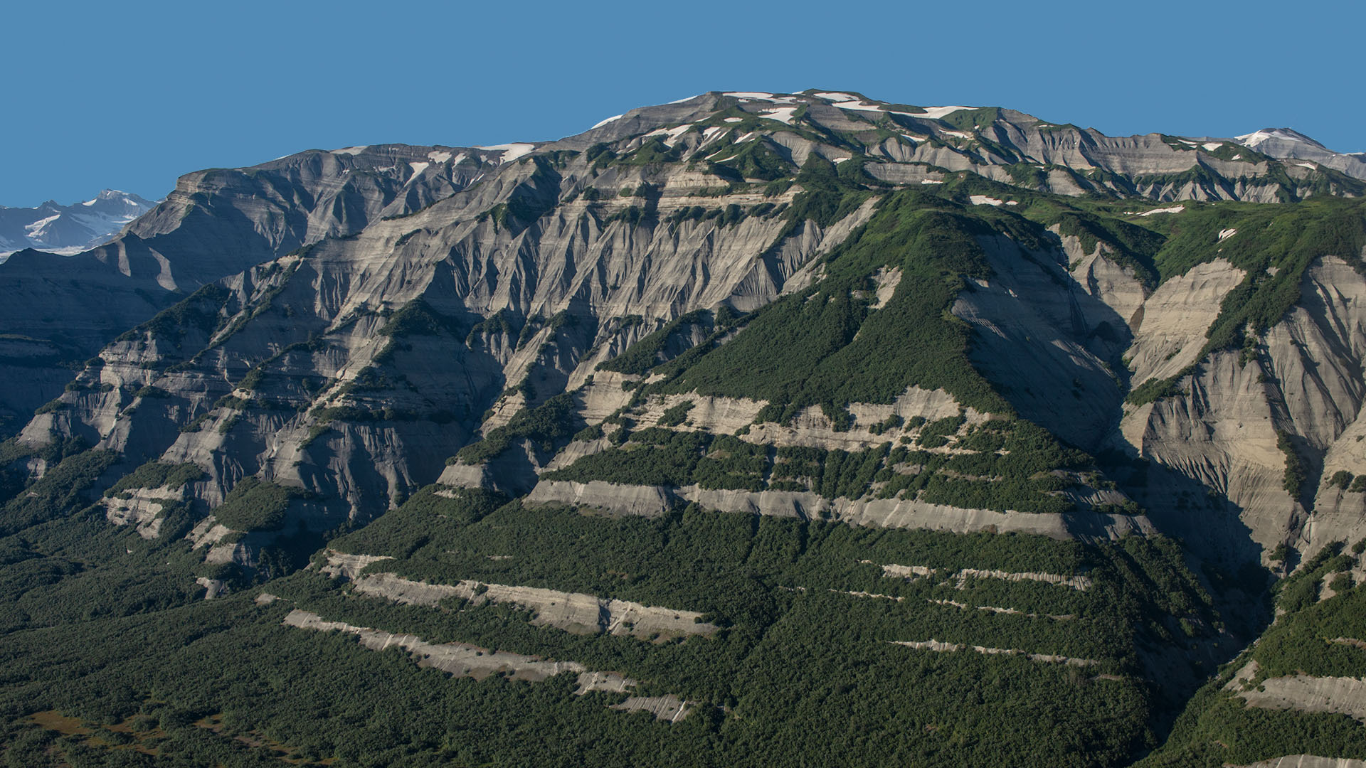
Karr Hills, Yakutat Terrane, southern Alaska, 2013. Photo by Richard Droker (flickr, Creative Commons Attribution-NonCommercial-NoDerivs 2.0 Generic license).
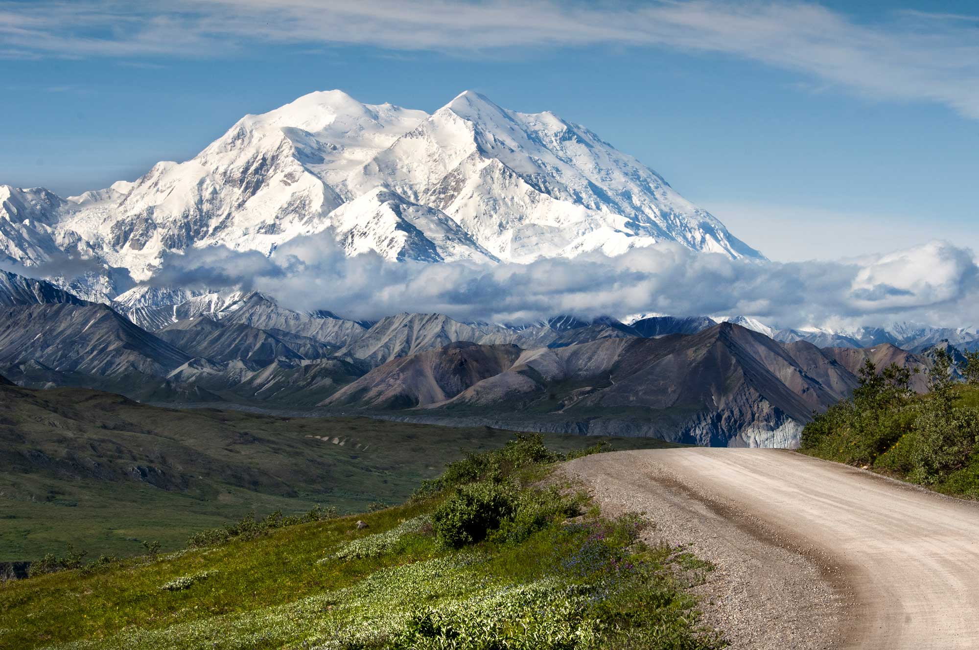
Denali (Mt. McKinley), Denali National Park and Preserve. NPS photo by Tim Rains (Denali National Park and Preserve on flickr, Creative Commons Attribution 2.0 Generic license, image resized).
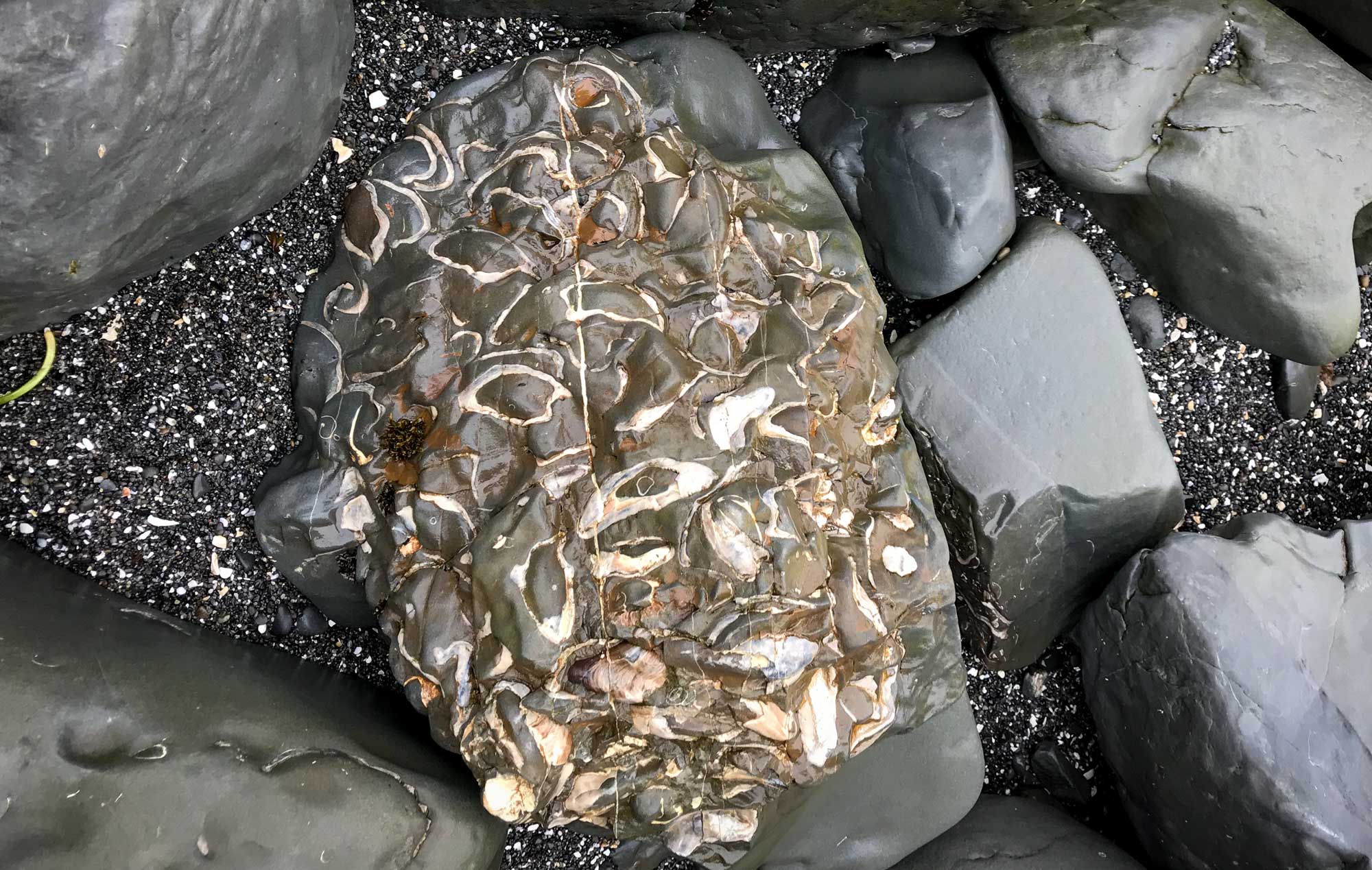
Mollusk fossils from the Miocene Narrow Cape Formation, Fossil Beach, Kodiak Island, Alaska. Photo by Arthur T. LaBar (flickr, Creative Commons Attribution-NonCommercial 2.0 Generic license, image cropped and resized).
Quaternary
At the start of the Quaternary period, approximately 2.5 million years ago, continental ice sheets began to form in northernmost Canada. During the Pleistocene, ice sheets advanced south and retreated north several dozen times, reaching their last maximum extent 25,000–18,000 years ago. Throughout this period, the northern half of North America has been periodically covered by continental glaciers that originated in northern Canada. During each ice age, sea level dropped as more and more seawater became locked up in glacial ice. As the oceans fell, coastlines moved farther out to sea. Later, as the climate warmed and sea level rose, the former coastal lands were flooded, drowning river valleys, glacial valleys, and coastal plains.
Last glacial advance
During the most recent glacial advance, approximately 20,000 years ago, portions of the Cordilleran Ice Sheet buried southern Alaska and northern Washington under a mile of ice, carving deep fjords and glacial valleys. This ice sheet deposited huge quantities of glacial sediment in low-lying areas such as Puget Sound and also carved rugged mountain landscapes.
All of Washington east of the Cascades was inundated and scoured by numerous enormous, violent floods, forming the Channeled Scablands. These floods occurred when an ice sheet alternately blocked and retreated from what is now the Clark Fork River in northwestern Montana and northern Idaho. When the river was blocked, an enormous lake called Glacial Lake Missoula built up behind the ice dam. When the ice dam later failed, the water was released catastrophically. These floods cut through the dust deposits and basalt that covered much of the region, leaving islands, escarpments, and channels so large that geologists did not at first recognize their origins.
Farther to the south, what are now modest mountain glaciers grew to become ice caps covering entire mountain ranges such as the Sierra Nevada and the Blue Mountains of Oregon.
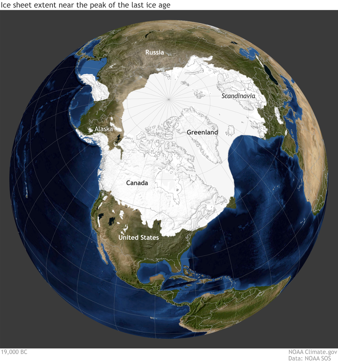
Earth during the last glacial maximum, around 20,000 years ago in the Pleistocene epoch. Much of North America was covered with a large sheet of glacial ice and the coastlines were different because sea level was lower. Reconstruction from climate.gov based on data from the University of Zurich Applied Sciences.
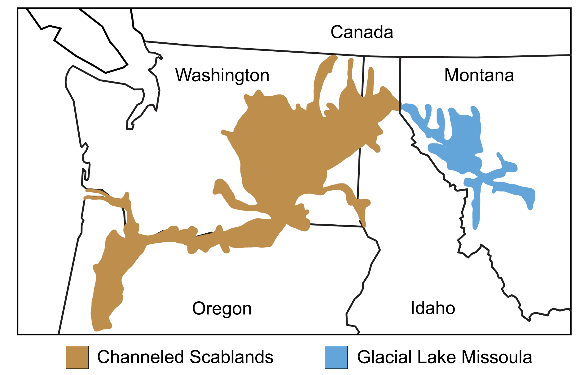
Map showing the extent of glacial Lake Missoula and the Channeled Scablands. Map modified from a map by Wade Greenberg-Brand, adapted from image by the Montana Natural History Center, originally published in The Teacher-Friendly Guide to the Earth Science of the Northwest Central US.
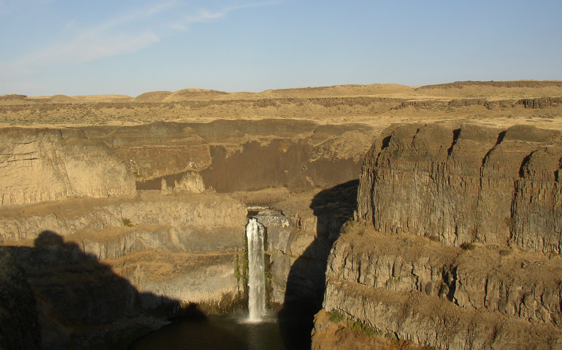
Palouse Falls on the Palouse River, Palouse Falls State Park, southeastern Washington. This area is part of the Channeled Scablands. Photo by Williamborg (Wikimedia Commons, Creative Commons Attribution-Sharealike 3.0 Unported license).
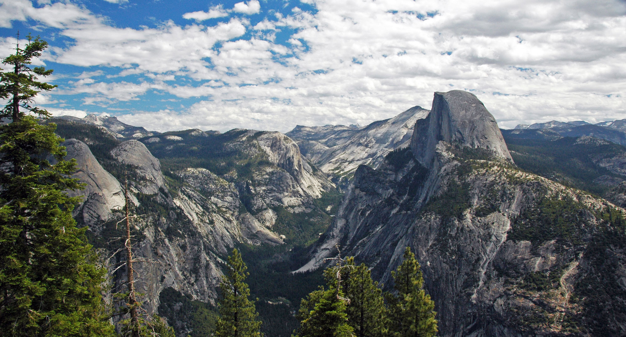
Yosemite Valley and Half Dome (the projecting rock formation on the right), Yosemite National Park, eastern California. The rocks that make up much of the Sierra Nevada are part of the Sierra Nevada Batholith made up of Mesozoic-aged intrusive igneous rocks. Yosemite Valley itself was carved by glaciers in the Pleistocene. Photo by James St. John (flickr, Creative Commons Attribution 2.0 Generic license, image resized).
Holocene
The Holocene epoch is the most recent (and current) period of retreat. The beginning of the Holocene is considered to be 11,700 years ago, or about 9700 BCE. While the “ice age” continues today, the Earth is in an interglacial stage, since the ice sheets have retreated for now. The glacial-interglacial cycling of ice ages indicates that the world will return to a glacial stage in the future, unless the impacts of human-induced climate change radically shift these natural cycles.
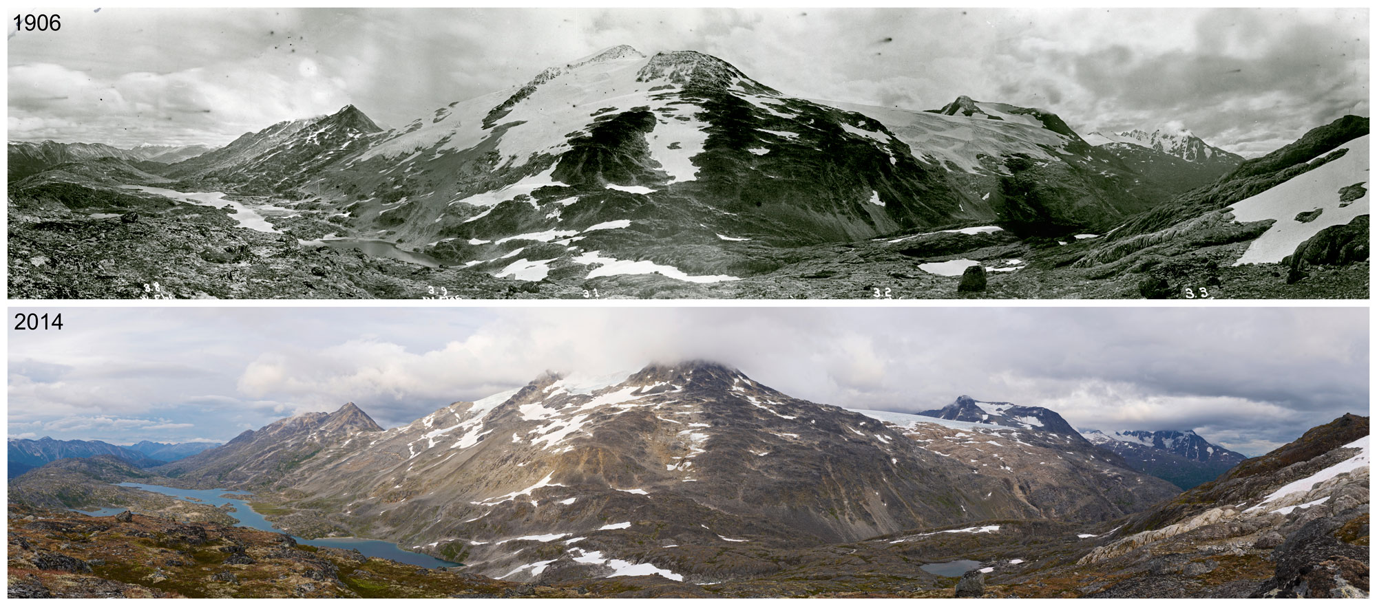
Chilkoot Pass on the Alaska-Canada border showing the retreat of glaciers. Top image is from 1906, bottom image is from 2014. Photos by George R. White-Fraser (International Boundary Commission, 1906) and Ronald D. Karpilo, Jr., and Sarah C. Venator (National Park Service, 2014). Source: NPS Climate Change Response on flickr (public domain).
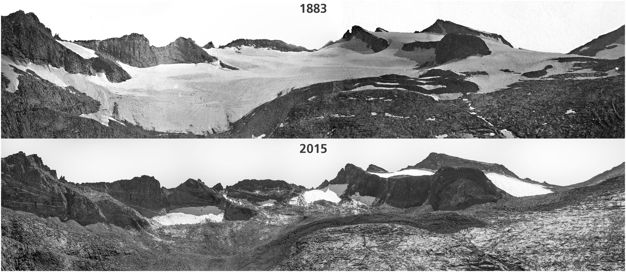
Lyell Glacier in 1883 compared to Lyell ice patch in 2015, Yosemite National Park, California. Photos by Israel Russell/USGS (1883) and Keenan Takahashi/NPS (2015). Source: NPS Climate Change Response on flickr (public domain).
Resources
Resources from the Paleontological Research Institution
Earth@Home: Here on Earth: Introduction to Plate Tectonics: https://earthathome.org/hoe/plate-tectonics