

Snapshot: Overview of the mineral resources of Alaska.
Topics covered on this page: Overview; Metallic Resources; Non-Metallic Resources; Resources.
Credits: Most of the text of this page is derived from "Mineral resources of the western US" by David Gillam, Alexandra Moore, and Gary Lewis, chapter 5 in The Teacher-Friendly Guide to the Earth Science of the Western US, edited by Mark D. Lucas, Robert M. Ross, and Andrielle N. Swaby (published in 2014 by the Paleontological Research Institution). The book was adapted for the web by Elizabeth J. Hermsen and Jonathan R. Hendricks in 2021–2022. Changes include formatting and revisions to the text and images. Credits for individual images are given in figure captions.
Updates: Page last updated June 10, 2022.
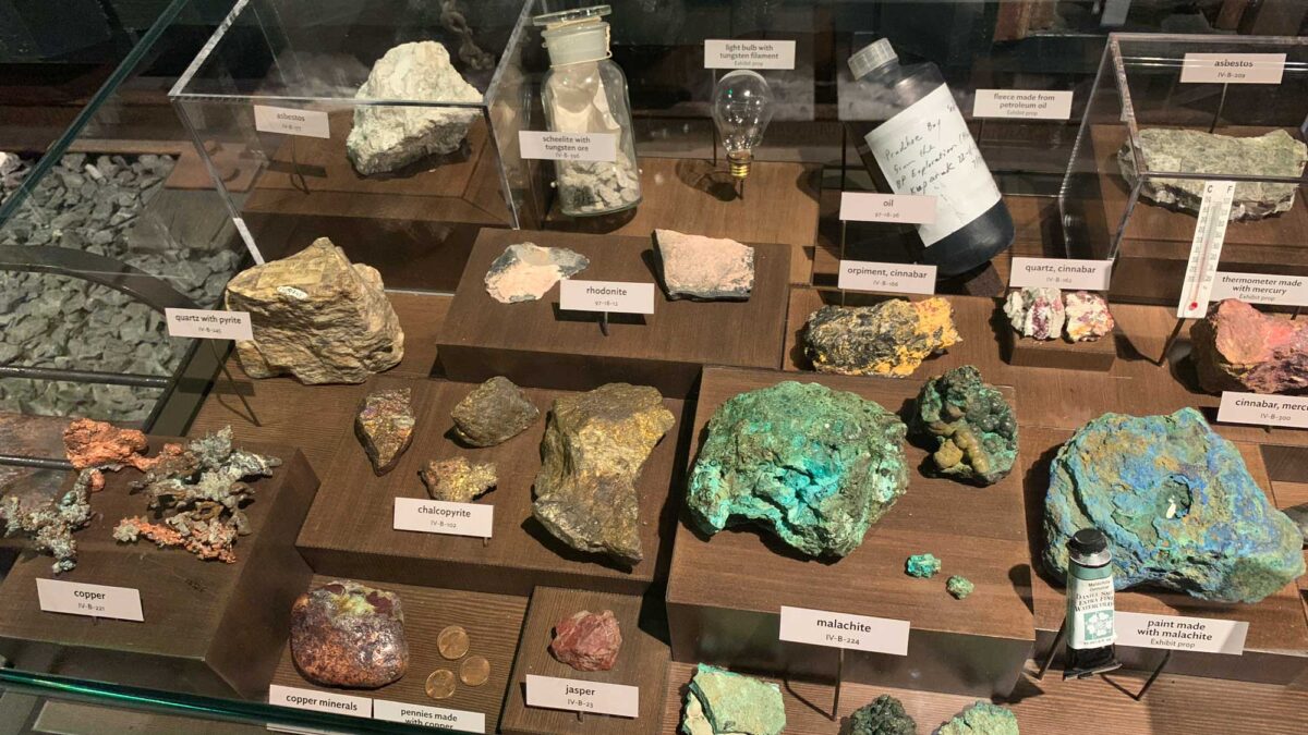
Image above: Some of the different types of minerals found in Alaska. Display at the Alaska State Museum in Juneau. Photograph by Jonathan R. Hendricks.
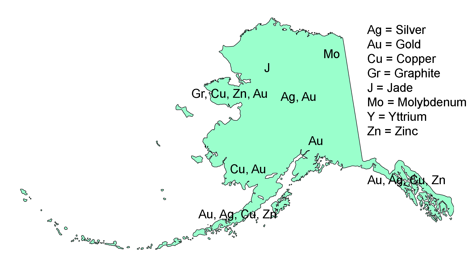
Locations of varied mineral resources in Alaska. Image by Jonathan R. Hendricks for the Earth@Home project.
Overview
Alaska encompasses a large landmass that contains a wide variety of mineral resources. However, difficulties associated with a lack of transportation and challenging environmental conditions (extreme cold, snow, and darkness) have limited the amount of mining that can occur there. Despite these obstacles, mineral resources continue to play an important role in the state’s development.
Alaska can be divided into separate areas, classified mainly by their differing modes of formation.
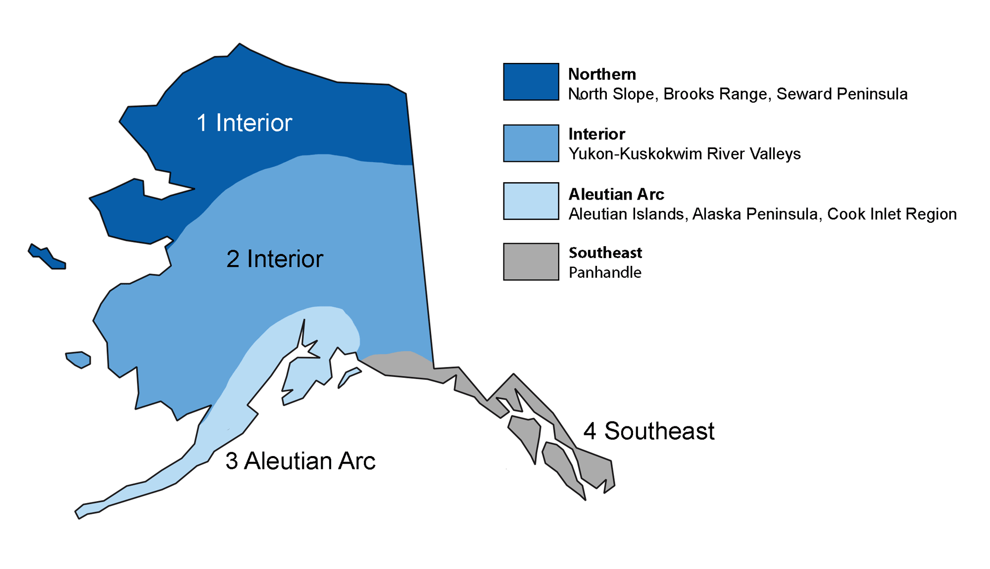
Common subdivisions of Alaska
Mineral Resources of Northern Alaska
Northern Alaska formed as the Yukon-Tanana terrane collided with the North American plate about 200 million years ago. This movement uplifted sections of the Arctic Sea floor, forming the Brooks Range and White Mountains, and leaving behind the Arctic Plain (North Slope) between the Brooks Range and the Arctic Ocean. Major oil and gas development has taken place on the Arctic Plain. Mineral deposits, including zinc, silver, gold, graphite, and jade, are found in and around the Brooks Range and the White Mountains.
Metallic Minerals
In the southern part of the Brooks Range, mineral deposits are found in Paleozoic-age metamorphosed sedimentary rocks that contain similarly aged basalt dikes. In several areas close to the Dalton Highway, small mining operations extract small quantities of placer gold. Near Coldfoot, larger-scale operations use hydraulic pumps to blast frozen gravel from hillsides that is then washed in large sluice operations.
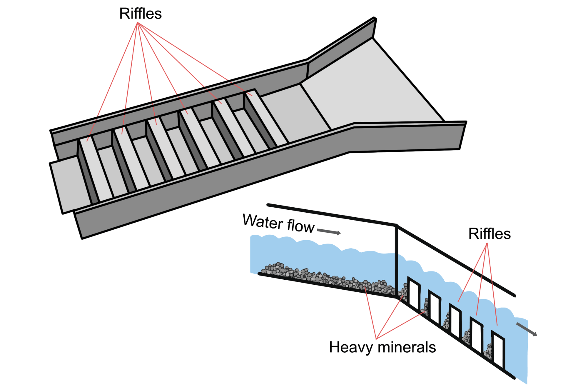
A sluice is a long tray through which water containing gold is directed. The sluice box contains riffles, or raised segments, which create eddies in the water flow. Larger and heavier particles, such as gold, are trapped by the eddies and sink behind the riffles where they can later be collected. Image by Wade Greenberg-Brand, modified for the Earth@Home project.
"How to Sluice for Gold: Gold Fever Ep164 Clip" by GoldFeverTV (YouTube).
On the western end of the Brooks Range, mineral deposits are found in Paleozoic black shales, creating a sulfide ore zone from which zinc and lead are mined. Because this area is north of the Arctic Circle, extreme winter conditions (with temperatures as low as -51°C [-59°F]) make mining in this area difficult. The placer gold found on the beaches of Seward Peninsula became the center of a gold rush in the late 19th century. The beaches around what eventually became the community of Nome were staked out and mined. Later, dredges were built on the rivers around Nome. Today, the beaches and ocean shelf around Nome are still home to a number of placer mining operations.
Non-Metallic Minerals
Northeast of Nome on the Seward Peninsula, a graphite mine—the Graphite Creek Deposit—is under development. The graphite here formed through metamorphism in the late Jurassic to early Cretaceous. It is generally found as flakes dispersed throughout the host rock, but can also be found in highly concentrated pockets.
Jade found in the Kobuk area has been mined in small amounts since the 1940s, and is used for jewelry and small, carved objects.
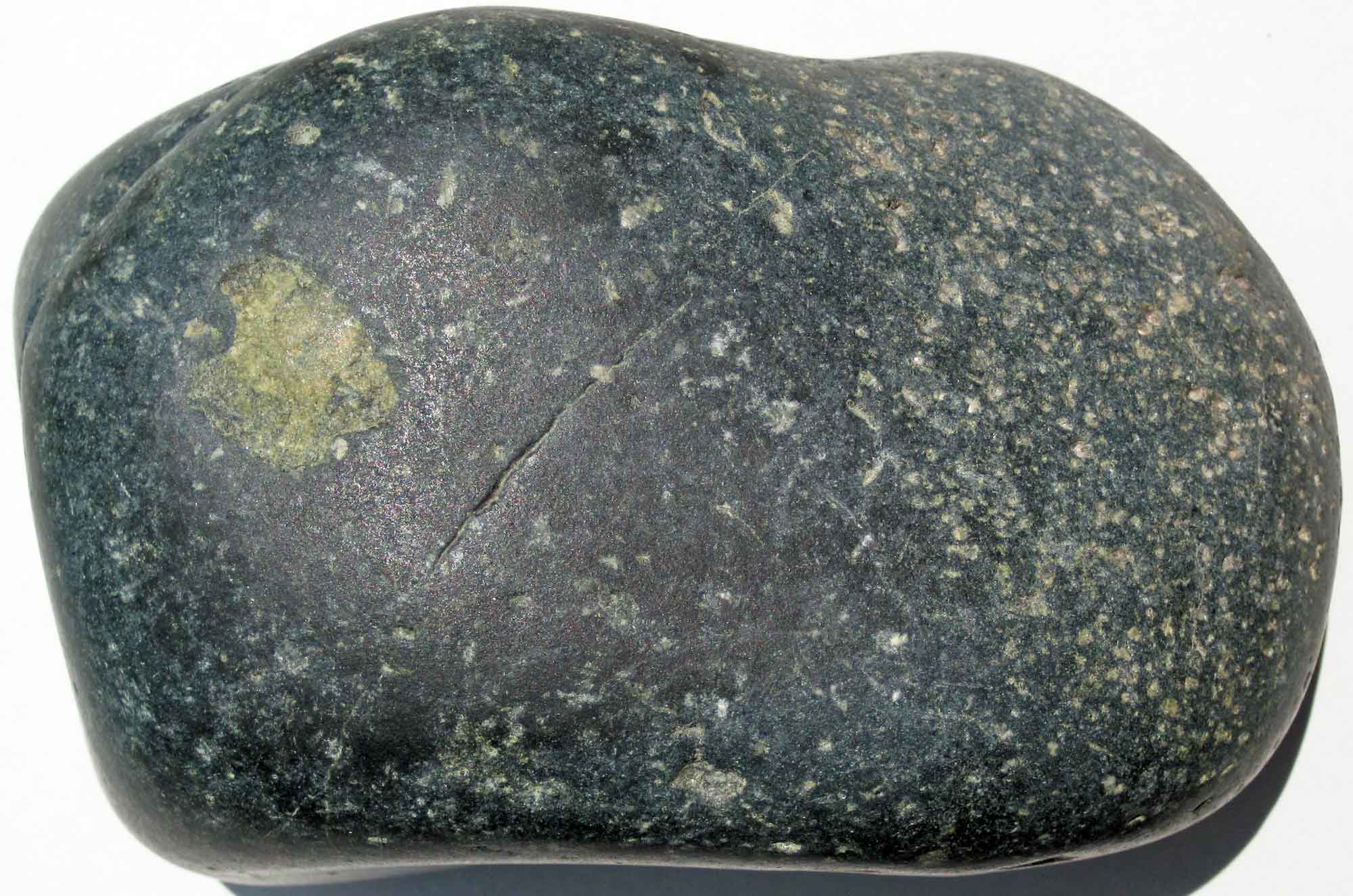
River-worn sample of nephrite jade from near Talkeetna, Alaska. Photograph by James St. John (Flickr; Creative Commons Attribution 2.0 Generic license).
The word “jade” is applied to two minerals that look similar and have similar properties: jadeite (a kind of pyroxene) and nephrite (a kind of amphibole). The two minerals are so similar that they weren’t distinguished from one another until 1863. Both minerals are formed during metamorphism and are found primarily near subduction zones, which explains why jade is abundant in a variety of locations along the active plate boundaries of both Alaska and the western continental U.S. The jade in northern Alaska is found in ultramafic and mafic rocks that formed during the middle to early Jurassic periods.
Mineral Resources of Interior Alaska
Alaska’s Interior lies between the Brooks Range to the north and the Aleutian Arc (and associated Alaska Range) to the south. It consists of sediment-covered crustal material from the Yukon-Tanana terrane. Two major river systems run through the Interior, along with a number of smaller rivers and tributaries, contributing to erosion and depositing sediments throughout. Placer gold mining brought prospectors to the area in the late 19th century, and mining remains an important industry there today.
Metallic Minerals
Prospectors first came to Alaska’s interior following the Klondike gold rush in the late 19th century.
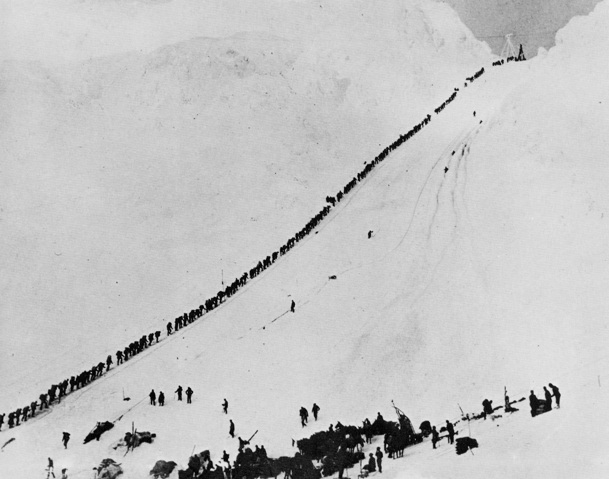
Numerous miners climb the Chilkoot Trail in September 1898 during the Klondike Gold Rush. Photograph by E. A. Hegg (Wikimedia Commons; public domain).
"Thomas Edison's Stunning Footage of the Klondike Gold Rush" by Smithsonian Channel (YouTube).
Mineral Resources of Interior Alaska
Alaska’s Interior lies between the Brooks Range to the north and the Aleutian Arc (and associated Alaska Range) to the south. It consists of sediment-covered crustal material from the Yukon-Tanana terrane. Two major river systems run through the Interior, along with a number of smaller rivers and tributaries, contributing to erosion and depositing sediments throughout. Placer gold mining brought prospectors to the area in the late 19th century, and mining remains an important industry there today.
Metallic Minerals
Prospectors first came to Alaska’s interior following the Klondike gold rush in the late 19th century. Miners who arrived to the Klondike too late to stake claims, or simply chose to move on, would travel down the Yukon River. Eventually, near Fairbanks, placer gold was found in the creeks and streams that feed into the Yukon and Tanana Rivers. These early claims led to massive dredging operations in the early 20th century.
"Chatanika Gold Dredge No. 3" by Sky Horse Tech (YouTube).
Today, two large gold mines are found in this area. The Pogo Mine near Delta Junction is in high-grade gneiss intruded by Cretaceous granitic bodies. Closer to Fairbanks, the Fort Knox Mine is found in a granite body known as the Fort Knox pluton. The gold is found in quartz veins, which are the precipitated remains of hydrothermal fluids that once circulated through the pluton. Although the gold has been concentrated in the quartz veins, the ore must be further processed in order to separate the gold from the quartz.
More recently, at the Pebble Deposit in the Kuskokwim River drainage, copper, molybdenum, and gold have been found in veins and within granitic rocks. In part of the deposit, these minerals are partially exposed at the surface, while other portions are concealed beneath younger volcanic and sedimentary rock.
Non-Metallic Minerals
Large amounts of sand and gravel (aggregate) are extracted throughout the area for use in road building and construction. Besides building new roads, aggregate is used to cope with the effects of climate change: as permafrost melts, soil compacts and overlying roads and infrastructure become unstable, requiring solid material to fill in the gaps. Large stone is also quarried for use as rip-rap along riverbanks in populated areas.
Mineral Resources of the Aleutian Arc
The Aleutian Island Arc lies along the southern edge of the North American plate in Alaska. This area is an active subduction zone, where the Pacific plate subducts beneath the North American plate. As the subducting plate descends and begins to melt, water is released from the oceanic crust; this leads to melting of the overlying mantle and the generation of volcanism. The result is an arc of volcanic islands that stretches 2500 kilometers (1550 miles) from the Alaskan mainland through the Aleutians to Russia’s Kamchatka Peninsula. The arc is relatively young and continues to change as a result of regional volcanism. Some small-scale mineral development has occurred, and exploration of the area’s resources is ongoing.
Metallic Minerals
Little is known about metallic deposits on the Aleutian Islands, and mining has occurred only in small pockets. On Unga Island, close to the Alaska Peninsula, gold and silver have been found in quartz deposits. Further out in the Aleutians, on Salt Island, the indigenous peoples collected native copper from the basaltic rocks for use as tools (such as awls, needles, and knives) and decoration.
Metallic mineral deposits are more common on the Alaska Peninsula itself, and also in the Cook Inlet. Placer gold deposits have been found on the beaches of the Alaska Peninsula and Kodiak Island, as well as in small creeks throughout the area. Deposits of copper and molybdenum have been found in the Pyramid Mountain area and are being explored for possible development.
In Cook Inlet, small placer deposits led to gold rushes during the early 20th century, and major mining operations started targeting underground deposits.
Along Turnagain Arm, near Anchorage, gold was found in Crow, Hope, and Six-Mile creeks. Placer mines were developed, and some individuals still mine these small claims.
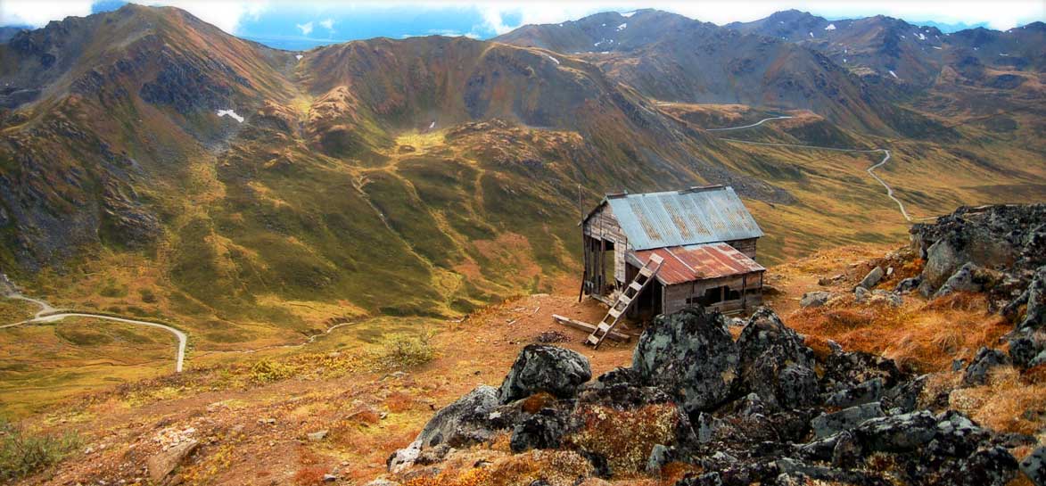
An old mining cabin in Hatcher Pass, Alaska, the home of Independence Mine. The first mining claims in this area were staked in 1906. Cecil Sanders (Flickr; Creative Commons Attribution 2.0 Generic license).
North of Anchorage, in the Talkeetna Mountains, placer gold was found in creeks. As prospectors moved to the headwaters of these creeks they found surface veins of gold, which led to underground mining at Independence Mine. The mine reached peak production in 1941 with a workforce of over 200 men blasting nearly 20 kilometers (12 miles) of tunnels and producing 975,677 grams (34,441 ounces) of gold. In 1942, shortly after the United States entered World War II, the War Production Board decided that gold was non-essential to the war effort. Gold mining throughout the United States was halted as a result—Independence Mine continued to operate, however, because of the presence of scheelite. Scheelite is a source of tungsten, a strategic metal for the war effort, and it was found in the same gold-bearing quartz veins being excavated by the mine. Since the production of scheelite was low, the mine closed in 1943. After the war, the price of gold dropped—mining at Independence was no longer profitable, and the mine closed for good in 1951.
Non-Metallic Minerals
Non-metallic minerals found in this area are used in the road and building industries. Large amounts of sand and gravel are extracted for use in road building and construction. In the Matanuska Valley and the Anchorage area, rivers and glaciers left large sedimentary deposits that provide an inexpensive source of sand and gravel.
After World War II, the city of Anchorage grew quickly, and it therefore needed building materials. A pumice mine was developed nearby, on volcanic Augustine Island. From 1946 to 1949, pumice was mined and transported by barge to Anchorage to be used as an additive in cement and concrete. The mining ended when Mt. Augustine erupted, destroying the roads and several structures on the island.
Mineral Resources of Southeast Alaska
Southeast Alaska is one of the state’s most geologically complex areas. It consists of a narrow archipelago of about 1100 islands and a thin strip of the Pacific Coast Range mountains, about 965 kilometers (650 miles) long with an average width of 193 kilometers (120 miles). Much of the land is mountainous, rising directly from sea level to great heights, and subsequently carved by recent glaciations. Since the last ice age, the removal of vast quantities of glacial ice from the landscape has allowed the land to rebound, elastically springing back to its former height (before it was compressed by the glaciers). This process, known as isostasy or isostatic rebound, has elevated the ocean shelf as much as several hundred meters (yards) above sea level.
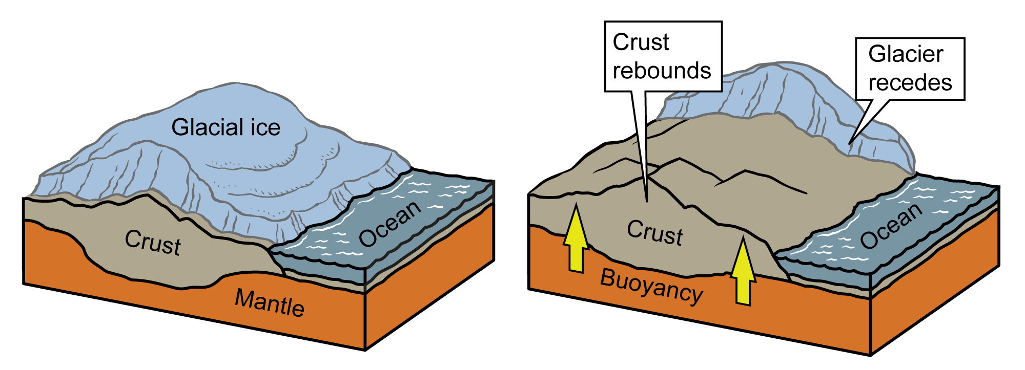
Isostatic rebound resulting from glacial retreat. Image by Jim Houghton, modified for the Earth@Home project.
Physical structures in the area are generally oriented from the northwest to the southeast. The islands have long axes in these directions, forming strips of land that are roughly parallel to each other. Rocks in Southeast Alaska can be subdivided into 10 groups: five terranes that have distinct geologic records and five rock groupings that are depositional, intrusive, or of unknown connection to the terranes. Most of the area is accessible only by plane or ship, making mineral development difficult. There are exceptions, however, such as large gold mining operations in the Juneau area and historical garnet mining near Wrangell.
Metallic Minerals
Alaskan gold was first discovered in the southeastern part of the state, as prospectors had been following the gold fi elds north from California in the 30 years since the finds at Sutter’s Mill in 1848–1849. By the 1870s, gold had been found in small amounts near Wrangell and Sitka. In 1880, a major strike took place in what would become Juneau, the state capital. At the far north of Southeast Alaska, the Kennecott Copper Mine was developed starting in 1900, and produced millions of tons of ore over 27 years of operation.
"The remote ghost town that put Alaska on the map" by BBC REEL (YouTube).
In addition to copper, the mines also produced a significant amount of silver. Today, gold is the primary metal mined in Southeast Alaska, although recent discoveries of silver, zinc, and lead in commercial quantities have led to new mines. Southwest of Juneau, on Admiralty Island, a large mine at Green Creek has been developed in schists metamorphosed from volcanic and sedimentary rocks—this mine produces gold, silver, copper, lead, and zinc produced by magmatic and hydrothermal processes.
Non-Metallic Minerals
A number of non-metallic minerals are currently mined in Alaska’s southeast. Near Wrangell, a garnet-bearing schist wall has been mined for specimen-grade garnets since the early 1900s.
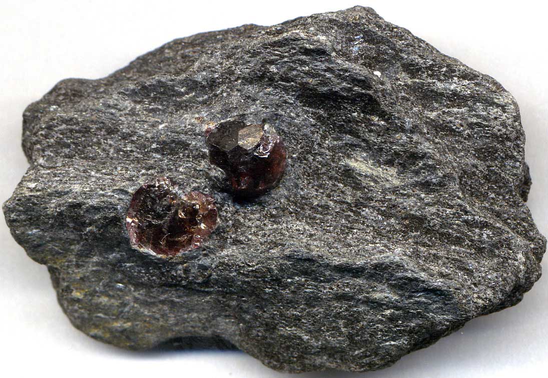
Garnets in schist from near Wrangell, Alaska. Photograph by James St. John (Flickr; Creative Commons Attribution 2.0 Generic license; image resized).
The mine is currently owned by the local Boy Scout Troop, which collects and sells the garnets to tourists. Further north at Gypsum Creek, a mine produces gypsum from the Paleozoic Iyoukeen Formation. At the southernmost end of the Panhandle, on Prince of Wales Island, Bokan Mountain is being explored for heavy rare earth elements. Surveys have shown that about 40% of the area (by weight) is composed of these rare elements, including dysprosium (used in nuclear reactors and data storage), terbium (used in solid-state devices and fuel cells), and yttrium (used in the production of lasers, electrodes, and superconductors).
Resources
Resources from the Paleontological Research Institution
Digital Atlas of Ancient Life: Minerals (collection of 3D models on Sketchfab): https://skfb.ly/6WxTo
Digital Encyclopedia of Earth Science: Minerals: https://earthathome.org/de/minerals/