

Page Snapshot: Introduction to Earth hazards of Hawai‘i.
Contents
Topics covered on this page: Introduction; Volcanoes; Earthquakes; Tsunamis; Floods and coastal hazards; Hazard preparation; Resources.
Credits:Most of the text on this page comes from "Earth Hazards of the Western US" by Wendy E. Van Norden, Alexandra Moore, and Gary Lewis, chapter 10 in The Teacher-Friendly Guide to the Earth Science of the Western US, edited by Mark D. Lucas, Robert M. Ross, and Andrielle N. Swaby (published in 2014 by the Paleontological Research Institution). The book was adapted for the web by Elizabeth J. Hermsen and Jonathan R. Hendricks in 2021–2022. Changes include formatting and revisions to the text and images. Credits for individual images are given in figure captions.
Updates: Page last updated July 1, 2022.
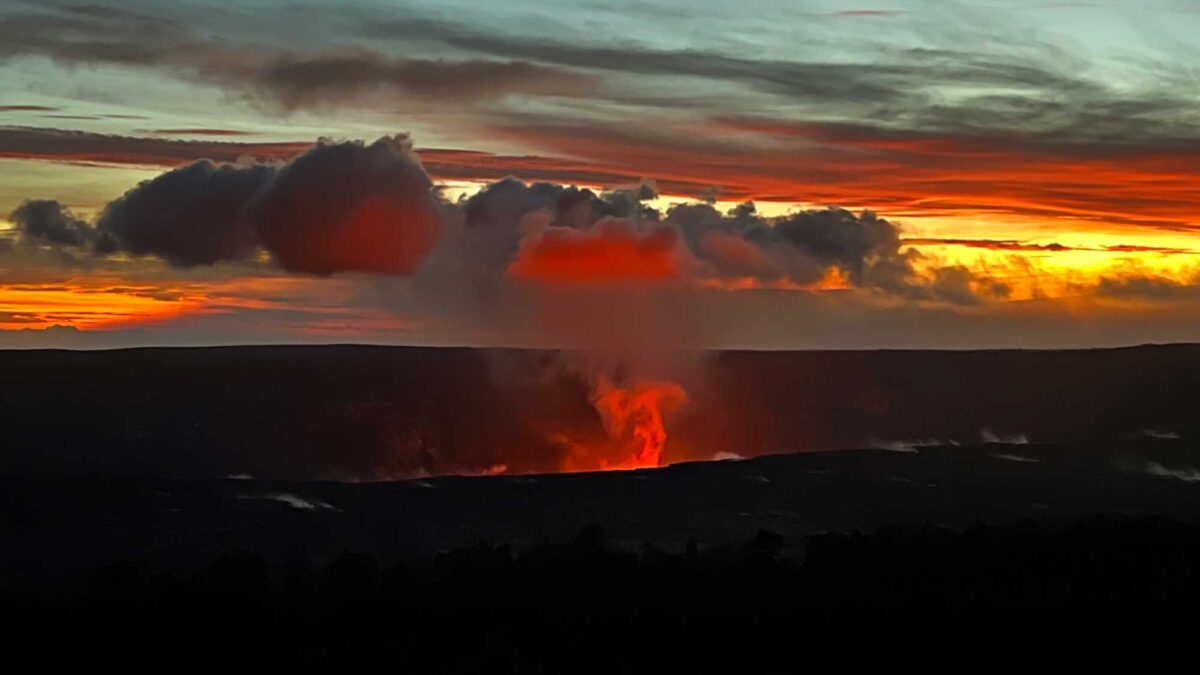
Image above: Original caption: "Sunset on the evening of December 8, 2021, provided stunning views of the eruption in Halema'uma'u crater, at the summit of Kīlauea. This photograph, taken from the Keanakākoʻi overlook within Hawai'i Volcanoes National Park, looks northwest from the south rim of Kīlauea caldera. Lava continues to erupt from a single vent in the western wall of Halema'uma'u crater, feeding a lava lake that occupies the western portion of the crater, though sporadic ooze-outs of lava continue to occur along the solidified lake margins." Photograph by C. Gansecki, USGS (public domain).
Introduction
The Hawaiian Islands are vulnerable to many of the same environmental hazards that are a cause for concern anywhere on Earth, and also to a few that are particular to the residents of Hawai‘i. As both a coastal region and an active volcanic area, hazards associated with oceanic and volcanic processes and their related effects are of greatest concern. Four main hazards characterize the Hawaiian Islands: volcanic eruptions, earthquakes, tsunamis, and floods and coastal hazards.
Volcanoes
Volcanic hazards include lava and ash eruptions, and the emission of corrosive volcanic gasses. The Hawaiian volcanoes erupt basaltic magma, which is characterized by low-viscosity—and therefore highly fluid—lava flows. These flows are often channelized, allowing them to move over long distances at relatively high speed (10s of kph [mph]), but affecting a well-defined and narrow zone. Today, most Hawaiian volcano hazards are associated with Kīlauea on Hawai‘i Island (Big Island).
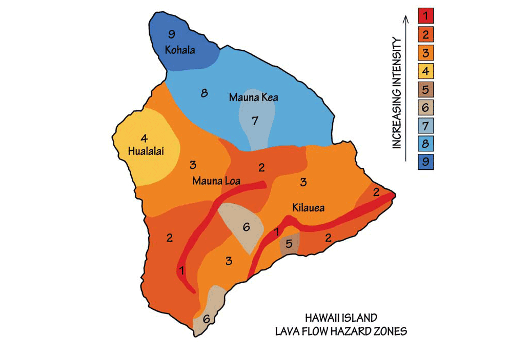
USGS Hawaiian Volcanoes Observatory map of Lava Flow Hazard Zones on Hawai‘i Island (Big Island). Adapted from original image by USGS (public domain).
Slow-moving Hawaiian lava flows pose little hazard to human life. However, structures or other immobile features (such as roads, agricultural areas, or other types of infrastructure) are often the victims of lava flows.
"Fresh lava prompts final evacuations in Hawaii" by CNN (May 27, 2018) (YouTube).
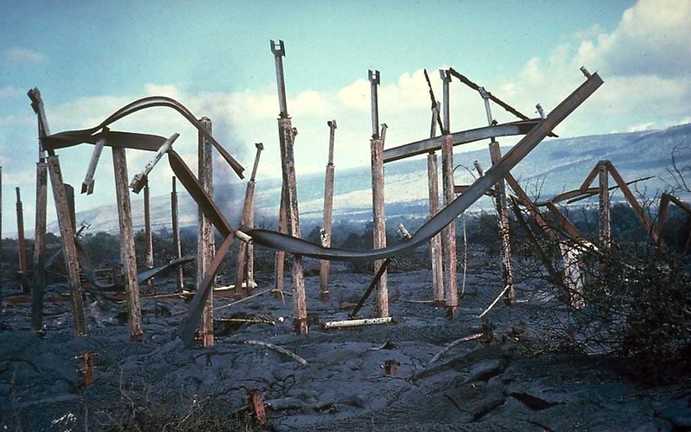
Remains of Waha‘ula Visitor’s Center in Hawai‘i Volcanoes National Park. Photograph by J. D. Griggs, USGS (public domain).
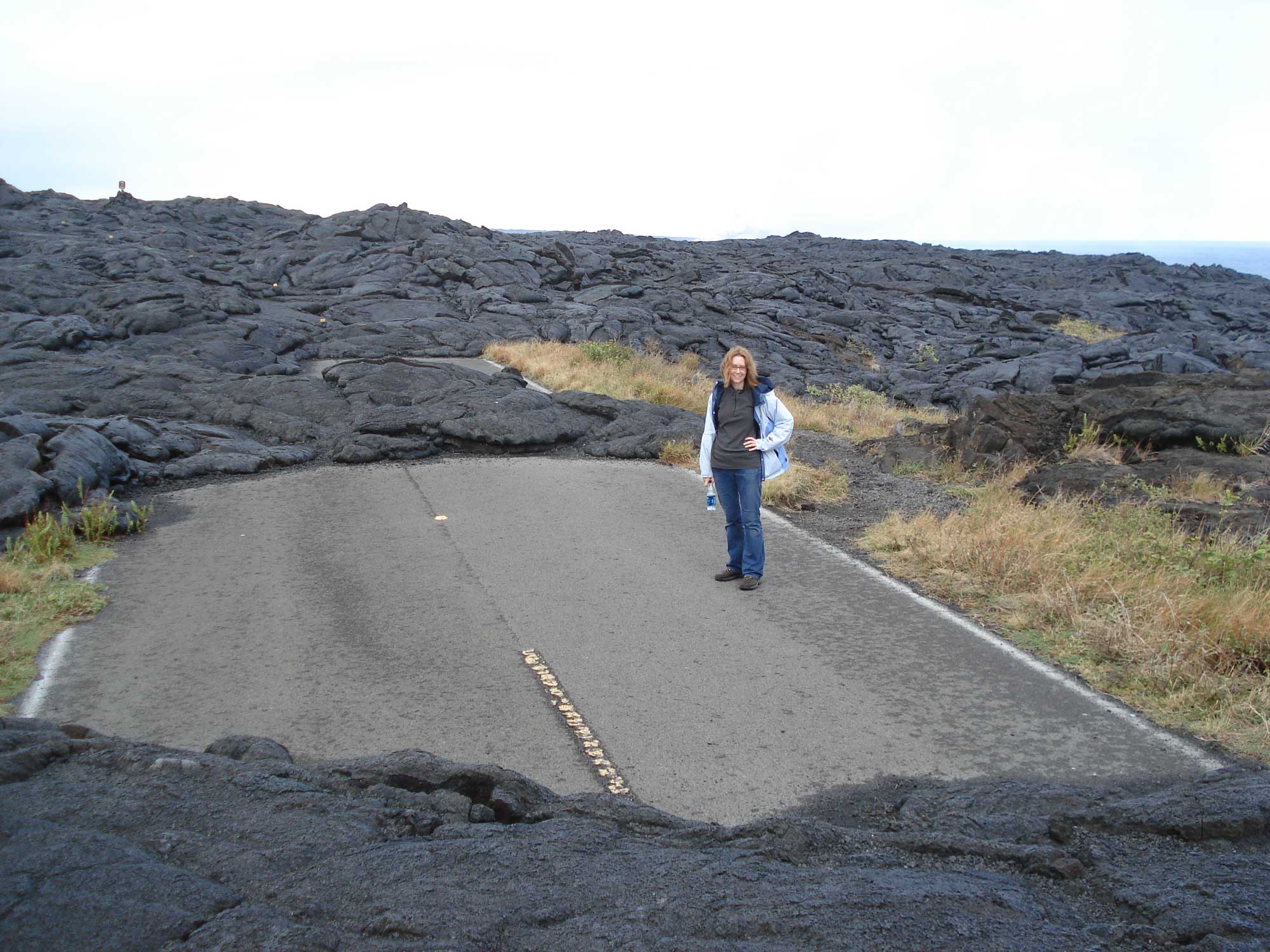
Lava flow partially covering a road at Hawaiʻi Volcanoes National Park. Photograph by Jonathan R. Hendricks.
As of 2018, the ongoing eruption of Kīlauea, which began in 1983, produced 4.4 cubic kilometers (1.1 cubic mile) of lava, covered 144 square kilometers (almost 56 square miles) of land, added 177 hectares (439 acres) of land to Hawai‘i Island, destroyed 215 structures, and buried 14 kilometers (9 miles) of highway. (Learn more about the history of this eruption here.) Historically, Kīlauea’s neighbors Mauna Loa and Hualālai have also experienced rapid, high-volume eruptions that would pose a hazard to the modern, more densely populated and urbanized flanks of these volcanoes today.
Occasionally, Hawaiian volcanoes erupt explosively. Kīlauea has had four explosive eruptive events in the last 100 years (1924, 2008, 2011, 2018) and six others in the last 1500 years. Although still gentle on the scale of global volcanism, these explosive eruptions are capable of blanketing large areas of Hawai‘i Island with ash and pyroclastic debris. When there is an unusual buildup of pressure within the magmatic plumbing system, an explosive eruption can result. Hawaiian volcanologists believe that the most common cause of explosive eruptions is the interaction of magma with groundwater. At Kīlauea this occurs when the floor of the summit caldera subsides to a depth near the water table: currently about 500 meters (1640 feet) below the surface. The most dangerous type of explosive behavior is a pyroclastic surge. Ash and volcanic gases race along the surface at extreme speed, with temperatures of several hundred degrees Celsius. The most recent pyroclastic surge from Kīlauea was in 1790, when many Hawaiians were overcome and killed. The estimated number of fatalities is between 80 and 5000; even the lower figure makes this the deadliest eruption in U.S. history.
Some large explosions from Kīlauea’s summit in the past have sent eruption clouds so high that they entered the west winds of the jetstream. As a result, their ash deposits were dispersed mainly in easterly directions. This is known to have occurred during explosive eruptions in 850–950 CE, about 1650 CE, and in 1790 CE. By contrast, the spectacular lava fountains of the 1959 eruption, the largest in the past 200 years, only sent material some hundreds of feet into the air, where it was dispersed to the southwest by the prevailing low-level trade winds. Although the on-land extent of the ash deposits is well known, all the ash layers extend offshore for unknown distances. An eruption on May 17, 2018 caused an ash cloud to reach a height of 30,000 ft.
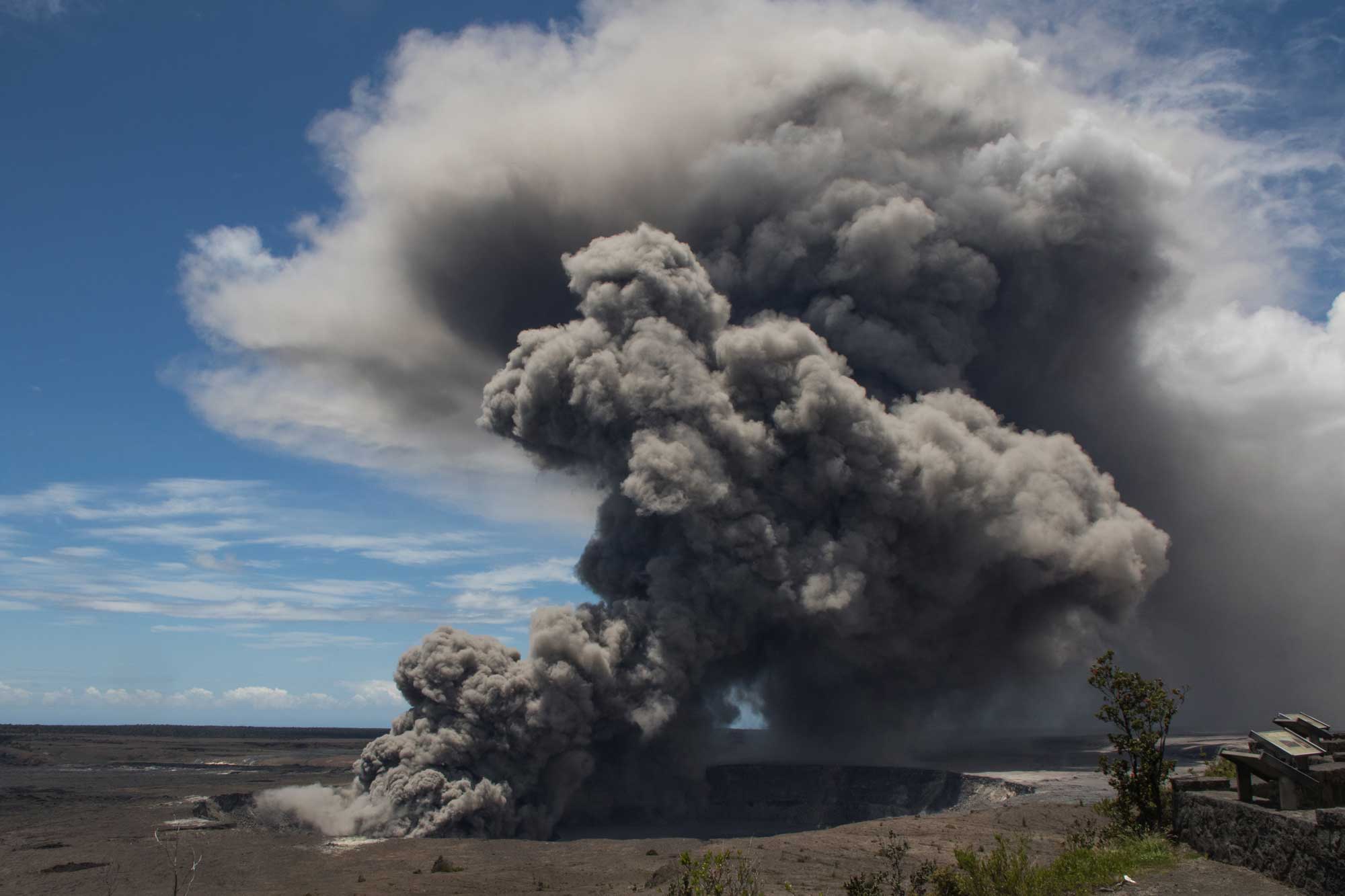
An ash cloud erupts from Kīlauea's crater in May 2018. Photograph by USGS (public domain).
Throughout a volcano’s period of activity, it also emits a suite of volcanic gases. At Kīlauea and Mauna Loa—Hawai‘i’s two most active volcanoes—the main gas plume components are water vapor, carbon dioxide, and sulfur dioxide (SO₂). Of these, SO₂ is of the greatest concern. Sulfur dioxide can react with water in the atmosphere to form sulfuric acid, and it reacts with sunlight and aerosols to form volcanic smog, or “vog.” Vog has been a problem throughout Kīlauea’s eruption from 1983 to present, with especially elevated levels since activity returned to the summit in 2008. In the post-2008 eruption period, emissions of SO₂ averaged 4000–6000 metric tons per day. This is a threat to people with respiratory ailments, and it also causes damage to agricultural crops in areas downwind of the summit eruption. A major eruption in the spring of 2018 caused levels of SO₂ to rise significantly.
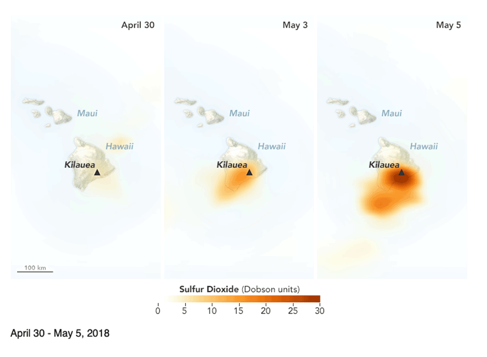
Increasing sulfur dioxide leaks from Kilauea between April 30 and May 5, 2018. Image from NASA Earth Observatory (public domain).
To understand volcanism and minimize volcanic hazards, the USGS has operated the Hawaiian Volcanoes Observatory on Kīlauea volcano since 1912. Volcanologists make visual observations and monitor ground deformation, seismicity, magma chemistry, and gas emissions in order to detect changes in volcanic behavior prior to an eruptive event. Hawaiian volcanoes commonly show clear precursors that signal the start of a new eruptive phase: most often an inflation of the volcano’s summit and increased seismicity beneath the volcano. The state of Hawai‘i has a robust civil defense warning system for volcanic (and other) hazards that alerts residents to potential threats.
Earthquakes
Hawai‘i is seismically active. Each year thousands of earthquakes occur in the Hawaiian Islands. Most earthquakes are linked to volcanism or the processes that form volcanoes. The seismicity map of Hawai‘i shows that earthquakes occur most frequently near Hawai‘i Island, the site of recent and active eruptions.
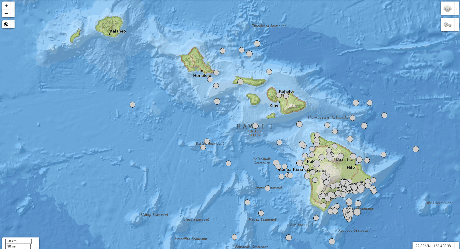
Hawaiian earthquakes of M3.5+ that occurred between 2011 and 2021. Screenshot from the USGS Earthquake Catalog (public domain).
From examination of the depth and distribution of seismicity, scientists recognize three types of earthquakes in Hawai‘i. The deepest earthquakes (16–56 kilometers; 10–35 miles) occur within the lithosphere and are related to stresses created by flexure of the lithosphere in response to the large mass load of the Hawaiian volcanoes. In 2006, an M6.7 earthquake of this type (depth of 38.2 km) caused widespread damage across northern Hawai‘i Island.
A second group of earthquakes occurs along the boundary between the Hawaiian volcanoes and the older oceanic crust on which they sit. Under the influence of gravity, the flanks of the volcanoes tend to spread. This spreading motion causes earthquakes along a nearly horizontal fault between ancient oceanic crust and the overlying, much younger, volcanic edifice. An M7.2 earthquake of this type occurred in Kalapana on the south coast of Hawai‘i Island in 1975. Similarly, faults visible on the surface appear to be related to this seaward motion of the volcanic flanks. In 1983, an M6.6 earthquake on Mauna Loa’s Ka‘oiki fault sent portions of Chain of Craters Road sliding into Kīlauea caldera.
The third suite of earthquakes are those caused by the migration of magma through volcanic conduits beneath the magma chamber. A common precursor to a volcanic eruption is an earthquake swarm known as harmonic tremor, which involves a set of early, continuous, low-magnitude vibrations (too small to be felt by people) that accompany the movement of magma toward the surface.
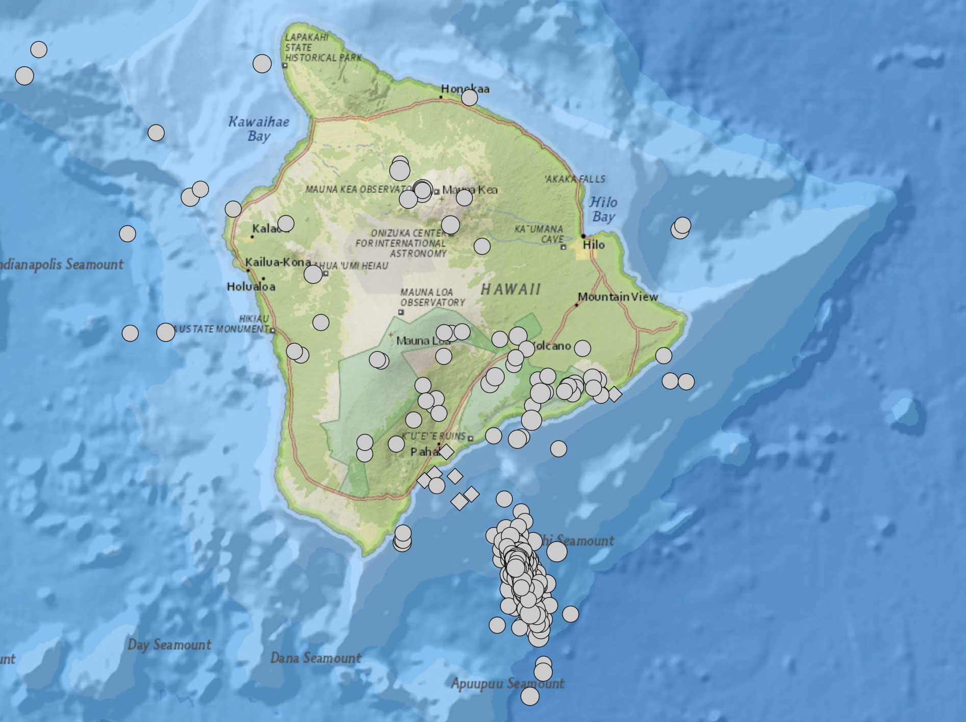
Earthquake swarm associated with the 1996 eruption of Lō‘ihi volcano. Screenshot from the USGS Earthquake Catalog (public domain); earthquakes are magnitude 2.5 or greater during the year 1996.
Although considered a hazard, earthquakes are also useful tools for probing the interior structure of Hawai‘i’s volcanoes. An array of seismometers on Hawai‘i Island detects small earthquakes that delineate fault zones dissecting the volcanoes. These instruments also allow volcanologists to map magma chambers and rift zones. There is an inverse relationship between the size of earthquakes and their frequency. Large earthquakes release large amounts of energy stored within the crust and lithosphere of the Earth, so they are infrequent. Smaller earthquakes occur all the time, releasing small amounts of energy. In Hawai‘i, microearthquakes occur every day. Fortunately, because Hawai‘i is not located on an active tectonic plate boundary there are no very large (M8.0+) earthquakes there.
Tsunamis
Tsunamis are ocean surges usually caused by large earthquakes that displace the ocean floor. Displacements can also occur because of large landslides triggered by an earthquake. The sudden displacement generates a shock wave that in turn can generate a series of waves in the ocean. These waves travel at high speeds across the ocean basins, up to 800 kph (500 mph). They have long wavelengths (200 kilometers; 120 miles) but low amplitudes and are only 30 to 120 centimeters (1–4 feet) in height. When such a wave train reaches shallow water the wave velocity slows and the wavelength decreases, but the amplitude increases, sometimes dramatically.
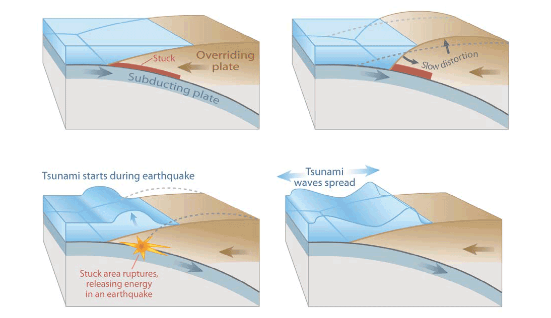
The steps involved in a megathrust earthquake and tsunami. Image by USGS (public domain).
The heights of tsunamis close to large earthquakes have exceeded 15 meters (50 feet) in Hawai‘i. Unfortunately, the use of the term “height” in tsunami reports can be confusing. In some cases it refers to the height of the oncoming surge of water above mean local sea level. In other cases it is used to describe the highest point reached by the wave, known as the “runup.” Runup heights are greater than wave heights, but descriptions do not always make the distinction clear.
Much of the Pacific Ocean is bordered by subduction zones, where many of the world’s largest earthquakes (and accompanying tsunamis) are generated. Because Hawai‘i is far from any subduction zone, there is usually ample warning time (5–15 hours) between the occurrence of a great earthquake and the arrival of a tsunami. Since earthquake waves travel through the solid earth ten times faster than tsunami waves cross the ocean, a large earthquake can be detected well before the arrival of a tsunami.
Historically, tsunamis have caused significant damage in Hawai‘i. For example, the great earthquake of 1946 in the Aleutian Islands (M8.1) generated tsunamis that caused substantial damage and loss of life in Hawai‘i. Wave heights reached more than 15 meters (50 feet) on Hawai‘i Island, and 159 people were killed in the state. This disaster led to the establishment of the first tsunami warning system, now known as the Pacific Tsunami Warning Center (PTWC). It monitors earthquake activity around the Pacific, and it also monitors pressure sensors deployed in the ocean that are sensitive to the passage of a tsunami wave.
"Narrated animation of March 11, 2011 Honshu, Japan tsunami propagation" by NOAAPMEL (YouTube).
In 1960, the largest earthquake ever recorded (M9.5) occurred off the Chilean coast, and again the damage was severe on Hawai‘i. Although the PTWC issued a warning, many people were complacent because large earthquakes in Kamchatka in 1952 and the Aleutians in 1957 had not produced significant tsunamis in Hawai‘i. The 1960 wave heights were highest (10 meters; 35 feet) in Hilo Bay, killing 61 people.
The Chilean Maule earthquake of 2010 (M8.8) and the 2011 Japanese Tōhoku earthquake (M9.0) both produced smaller tsunamis in Hawai‘i, with wave heights of 1–3 meters (3–10 feet). Both were well predicted by the PTWC, and no fatalities occurred. Heightened public awareness after the 2004 Sumatran earthquake and tsunami in the Indian ocean may have played a role.
There is no simple relationship between the magnitude of an earthquake and the magnitude of tsunamis it may generate. The direction of the tsunami wave’s arrival and how it interacts with local sea floor topography can greatly influence the wave’s height. Tsunami waves can “bend” or refract around topographic features, as occurred in the case of the 1960 Hilo Bay tsunami. Local earthquakes in Hawai‘i can also generate tsunamis, for which warning times will naturally be much shorter. In 1975, an M7.2 earthquake off the southeast coast of Hawai‘i generated a pair of tsunami waves, the second of which reached a height of 8 meters (26 feet) at Halapē and caused two fatalities.
Floods and coastal hazards
Hawai‘i is a mountainous tropical archipelago, thus floods are a frequent occurrence. Flash floods occur, on average, eight times a year in Hawai‘i, with the highest frequency seen during the rainy season from October to April.
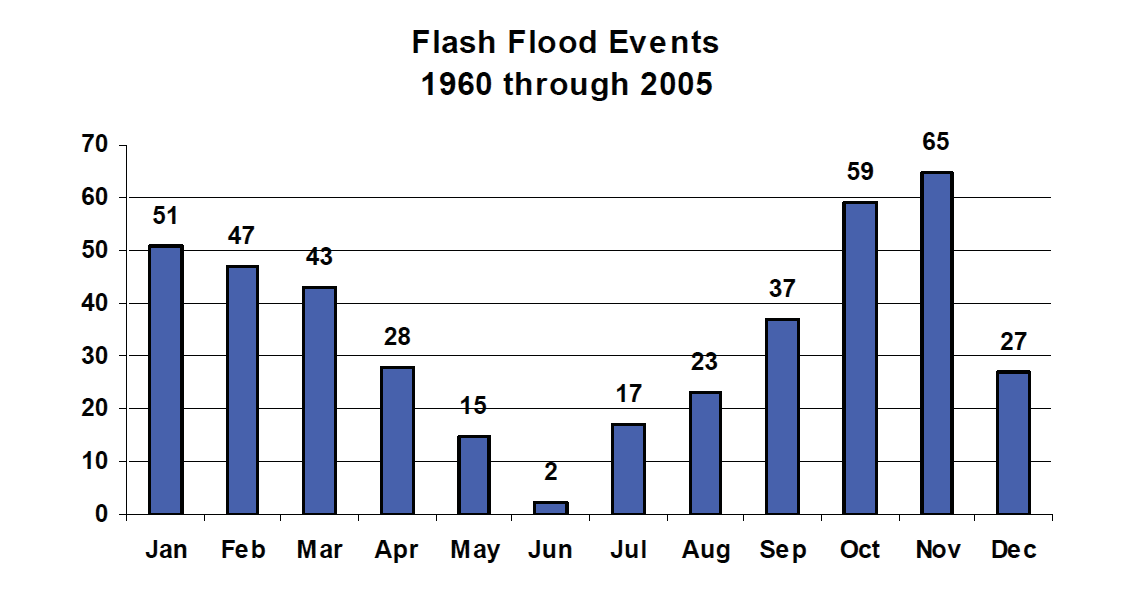
NOAA data on flash flood frequency in Hawai‘i (public domain).
Hawai‘i’s watersheds are small and its streams are “flashy,” meaning that they can change quickly from dry to overflowing in a matter of minutes. Flood events cause landslides that can block roadways, or sometimes wash away a section of highway or infrastructure (e.g., water pipes, bridges, agricultural ditches). The rural nature of most of the Hawaiian Islands means that a washed-out road is a significant disruption, since few alternate routes exist. In addition, flash floods carry high sediment discharge, particularly in areas with degraded or highly modified terrestrial ecosystems. Hawai‘i’s fringing coral reefs are negatively impacted by pulses of flood-borne sediment, as corals require sunlight and clear water to maintain ecosystem health.
Like any coastal region, Hawai‘i is subject to hurricanes and storm surge. Hurricanes occur when a warm and moist tropical low-pressure air mass forms over portions of the ocean. These storms gather strength because the warm summer ocean water evaporates, creating very humid, low-pressure air. The air rises and condenses into water droplets that form clouds and release latent heat. The latent heat provides energy for even greater evaporation of warm ocean water, and thus the cycle continues until the low-pressure center moves over land. These storms are considered tropical depressions when wind speeds are below 63 kph (39 mph). As the storm develops a more organized structure, however, with more concentrated rising warm air in the center and bands of rain, it will officially become a tropical storm when its wind speeds reach the 63 to 117 kph (39 to 73 mph) range. Once winds have reached 119 kph (74 mph), the storm is classified as a hurricane. About four to five hurricanes occur in the central Pacific every year, but almost every storm system that reaches Hawai‘i has degraded to a tropical storm or tropical depression by the time it makes landfall. In terms of loss of human life, storm surge and high surf are the deadliest natural hazards in the Hawaiian Islands. Storms from any part of the Pacific can cause big swells and high surf on Hawaiian coasts. Hawai‘i’s north shores are famous for winter surf arising from storms in the north Pacific, while in summer, big waves strike south-facing shores.
Hazard preparation
The historical record of natural disasters in Hawai‘i has prompted the creation of a robust system of warning and response for island communities. USGS seismometers, GPS, and associated instrumentation monitor earthquake and volcanic hazards, while NOAA buoys across the Pacific monitor marine conditions and NOAA/NASA satellites monitor the atmosphere and ocean.
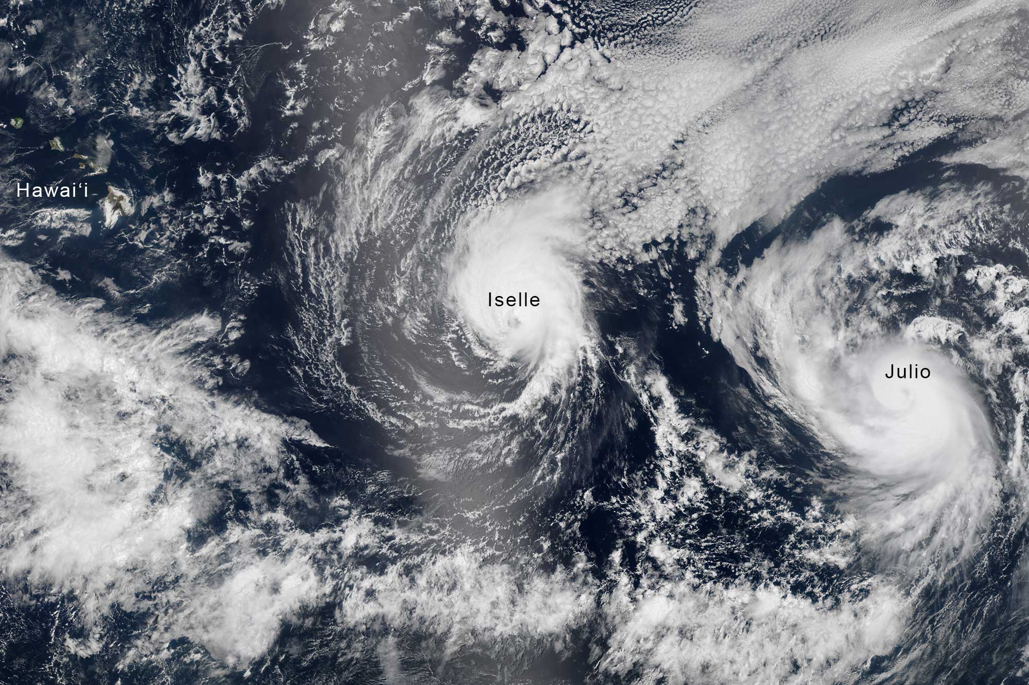
Hurricanes Iselle (left) and Julio (right) lining up on the Hawai‘ian Islands, August 6, 2014. Modern hazard forecasting and warning systems reduce the impact on humans. Satellite image by NASA MODIS / NASA Earth Observatory (public domain).
These inputs are networked with real-time response systems, including NOAA’s National Weather Service and PTWC, and Hawai‘i’s state and county Civil Defense offices. Hazard information is broadcast to the public through computerized warning services (e.g., radio, internet, reverse-911) and through an island-wide system of civil defense sirens.