

Page snapshot: Introduction to the geologic history of the Hawaiian Islands and Emperor Seamount chain.
Topics covered on this page: The big picture; Lifecycle of Hawaiian volcanoes; Deep submarine stage; Shallow submarine/early shield stage; Subaerial shield-building stage; Post-caldera stage; Erosional stage; Reef-building stage; Rejuvenated post-erosional eruptions; Atoll stage; Guyot stage; Hot spot volcanoes and Hawaiian tradition; Resources.
Credits: Most of the text of this page is derived from "Geologic history of the Western US" by Frank D. Granshaw, Alexandra Moore, and Gary Lewis, chapter 1 in The Teacher-Friendly Guide to the Geology of the Western US, edited by Mark D. Lucas, Robert M. Ross, and Andrielle N. Swaby (published in 2014 by the Paleontological Research Institution; currently out of print). The book was adapted for the web by Elizabeth J. Hermsen and Jonathan R. Hendricks in 2022. Changes include formatting and revisions to the text and images. Credits for individual images are given in figure captions.
Updates: Page last updated June 22, 2022.
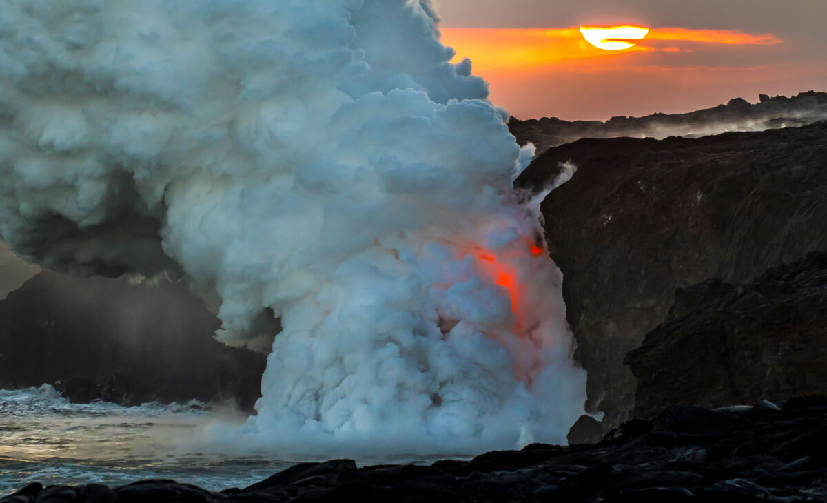
Image above: Lava flowing in the ocean, Kalapana, Hawai'i Island, 2017. Photo by Hawai'i Volcanoes National Park on flickr (public domain).
The Big Picture
Hawai'i is located thousands of kilometers from the nearest plate boundary, but it is volcanically active and geologically very young. The oceanic crust on which the Hawaiian Islands reside is nearly 90 million years old, yet the oldest of these islands was formed a mere 5 million years ago. In fact, the youngest is less than a half million years old.
The Hawaiian Islands are the surface expression of a mantle hot spot—a place where a large slab of crust rides over the top of a rising plume of hot rock in the underlying mantle. The Hawaiian hot spot has its origin deep within the Earth, near the core-mantle boundary, where an area of anomalously high temperature creates a thermal plume. A thermal plume is a zone of solid mantle material that moves slowly upward toward the surface. Thermal stress drives the motion of the plume; the hotter material rises because it is less dense and therefore more buoyant than its surroundings. As magma created by the plume erupts onto the seafloor, repeated lava flows build a massive volcano that eventually reaches the surface of the ocean and becomes a volcanic island.
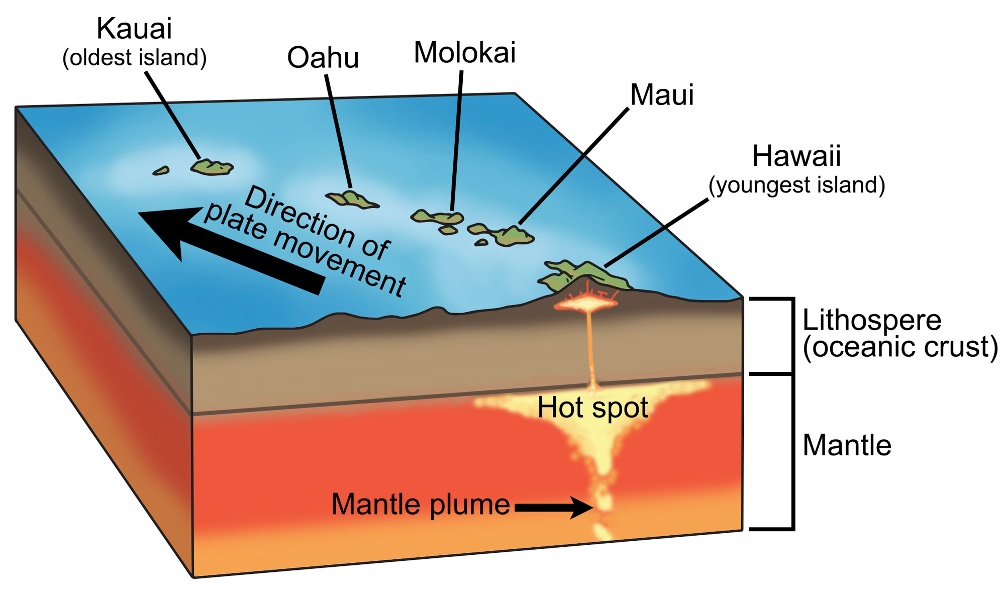
Diagram showing the hot spot beneath Hawaii. Magma rises up in a plume from the Earth's core, forming a magma in the upper mantle. The magma rises, causing volcanic activity on the surface. Hawaii is the youngest of the Hawaiian islands and active volcanism still occurs there. As the Pacific Plate continues to move, it will eventually be supplanted by another island. Modified from a diagram by Wade Greenberg-Brand (originally published in The Teacher-Friendly Guide to the Earth Sciences of the Western US, after a diagram by Tasa Graphic Arts, Inc.).
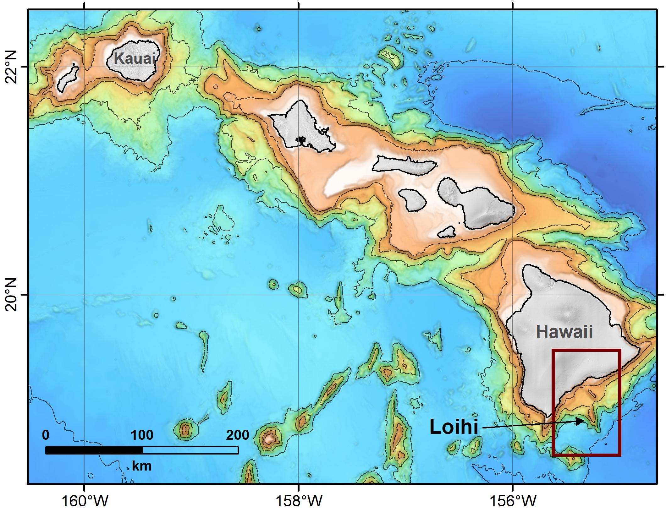
The Hawaiian hot spot lies beneath the Pacific plate, where it maintains a relatively fixed position within the mantle. The overlying Pacific plate moves to the northwest at the tectonically rapid rate of 8.5 centimeters per year (3 inches per year). The movement of the plate over the hot spot has created a chain of volcanoes that extend 5800 kilometers (3600 miles) from the Hawaiian Islands to the Emperor Seamounts. The youngest islands in the Hawaiian-Emperor seamount chain are currently over the hot spot and still volcanically active; in contrast, the older, extinct islands reveal the track that the oceanic crust has followed as it has moved over the hotspot.
They Hawaiian Island-Emperor Seamount chain acts as a time machine through which we can look either forward or backward at the creation and evolution of the islands. The age of the volcanoes increases with increasing distance from the hot spot. The Emperor Seamounts, the northernmost end of these undersea mountains, are the older volcanoes. The oldest, Meiji Seamount, is now in the far north near the Aleutian trench; this seamount is 80 million years old, which indicates that the Hawaiian hot spot has been active since at least the Late Cretaceous. The Hawaiian Islands are the southernmost end of the volcano chain and the youngest. The Hawaiian hot spot remains active today, erupting new lava at Kīlauea volcano and the still-submerged Kama'ehuakanaloa Seamount (formerly Lō'ihi Seamount), the youngest volcano in the chain.
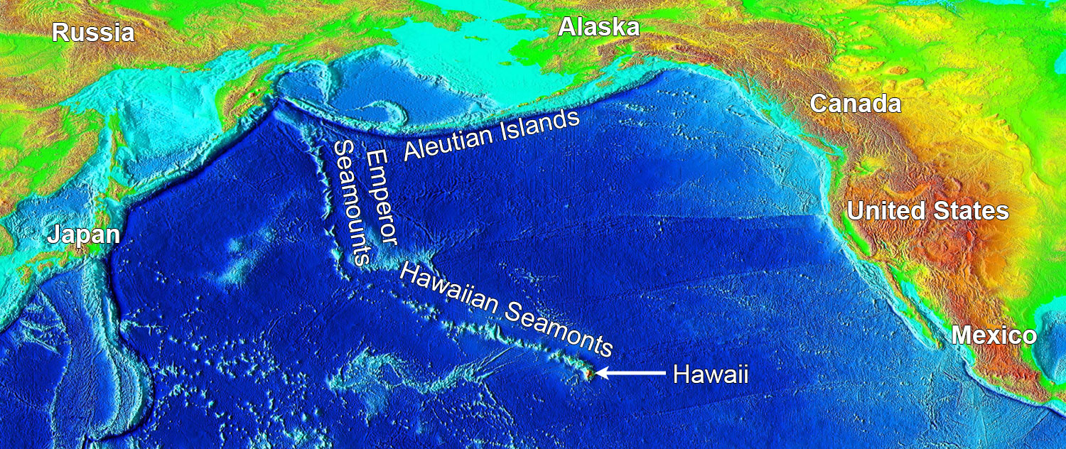
False-color image of the Pacific showing bathymetry and elevation. The Hawaiian Seamounts and the Emperor Seamounts are a continuous chain of islands and seamounts (volcanic mountains that are submerged) produced by a hot spot under the Pacific Plate. The seamount chain extends for 5800 kilometers (3600 miles), ending near the eastern end of the Aleutian Island chain, which was formed by subduction of the Pacific Plate. Image by National Geophysical Data Center/USGS (Wikimedia Commons, public domain).
Lifecycle of Hawaiian volcanoes
For more than 50 years, geologists have recognized that Hawaiian volcanoes exhibit a relatively consistent set of features reflecting events in the island’s lifecycle. As each volcano forms above the Hawaiian hot spot and moves away, it undergoes a sequence of constructive and then destructive processes. These events are typically divided into nine stages, although (as with all natural processes) there may be overlap and gradation between them and not all Hawaiian volcanoes go through every stage of development described here. As they pass through the stage of their lifecycle, Hawaiian volcanoes change in morphology (form) and behavior, and the lavas they erupt change chemically. Early lavas are derived from near the edge of the thermal plume, a magmatic source that is chemically different from lavas derived from the center of the plume.
As one of the best-developed examples of an oceanic hot spot system, the Hawaiian Islands provide a unique window into geologic processes.
1. Deep submarine stage
We assume that all Hawaiian volcanoes begin with a deep submarine stage, in which magma erupts through the seafloor and solidifies. During this stage, the magma is made up of alkalic basalt, which is derived from the edge of the thermal plume. Alkalic basalts contain around 47% silicates and are relatively high in sodium and potassium. They erupt as dense lava flows form the initial volcanic shield on the seafloor. Kama'ehuakanaloa Seamount (formerly Lō'ihi Seamount), currently forming off the south coast of Hawai'i Island, is an example of the deep submarine stage.
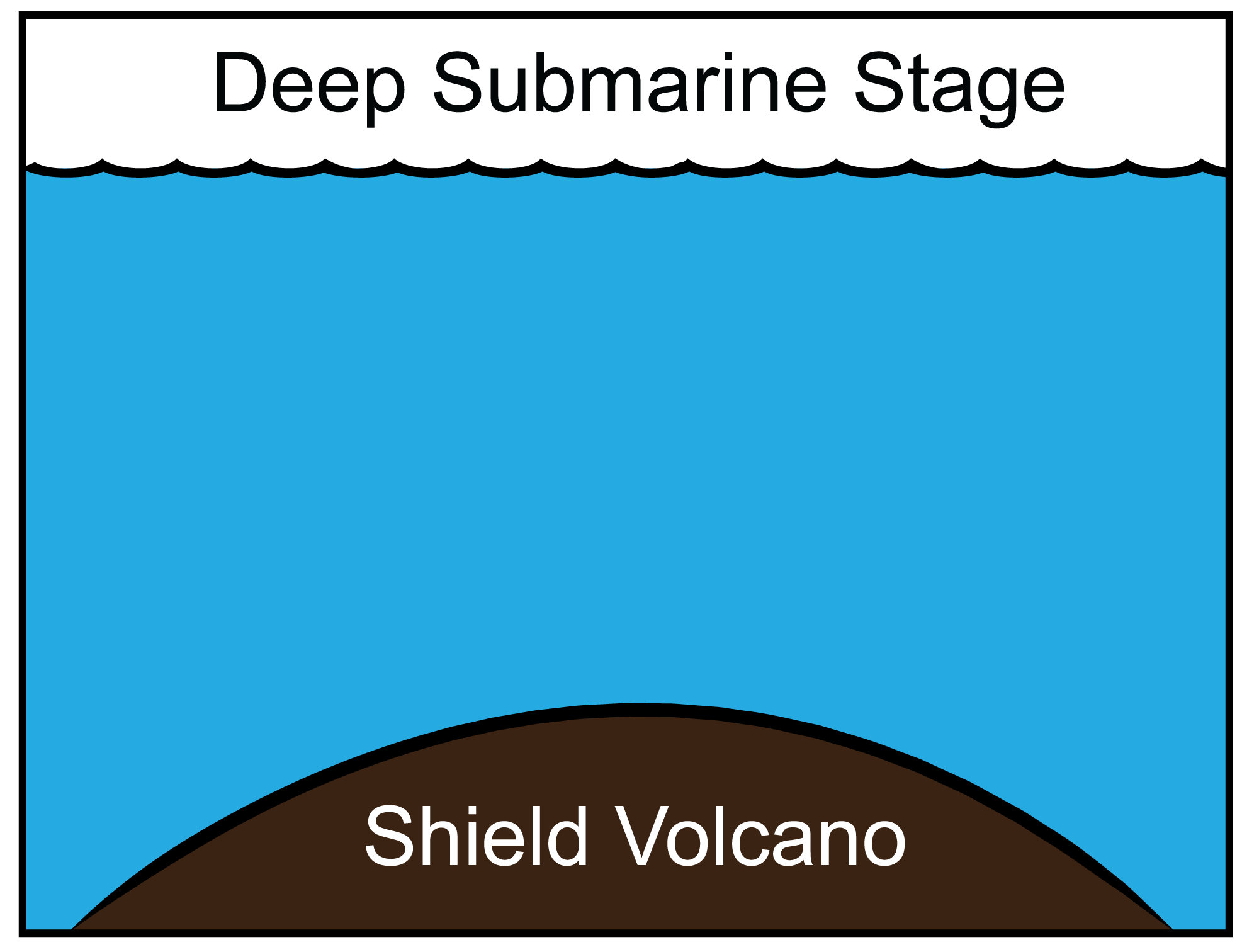
Deep submarine stage of volcanic island formation. Modified from a diagram by Andrielle Swaby, originally published in The Teacher-Friendly Guide to the Geology of the Western US.
Bathymetric map showing Kama'ehuakanaloa Seamount (formerly Lō'ihi Seamount) off the coast of Hawai'i Island. Source: Clague et al. (2019) Frontiers in Earth Science 7: 58.
2. Shallow submarine/early shield stage
Early dense lava flows accumulate to create a broad submarine shield. When lavas erupt on the deep sea floor, the pressure of the overlying water column keeps gases like oxygen, carbon dioxide, and hydrogen sulfide dissolved in the magma. However, as the growing volcanic shield approaches the ocean surface, the gases begin to form bubbles in the magma, or exsolve. These bubbles can be preserved in the chilled lava as vesicles. The exsolving gasses can also contribute to a more violent style of eruption. When the summit of the growing volcano approaches the sea surface, the interaction of seawater with the erupting magma can be quite spectacular, characterized by jets of steam, shattered rock, and vaporized lava. No eruptions of this type occur in modern Hawai'i. Based upon similar eruptions observed in Iceland and elsewhere in the Pacific, however, we hypothesize that they must have been part of Hawai'i's past.
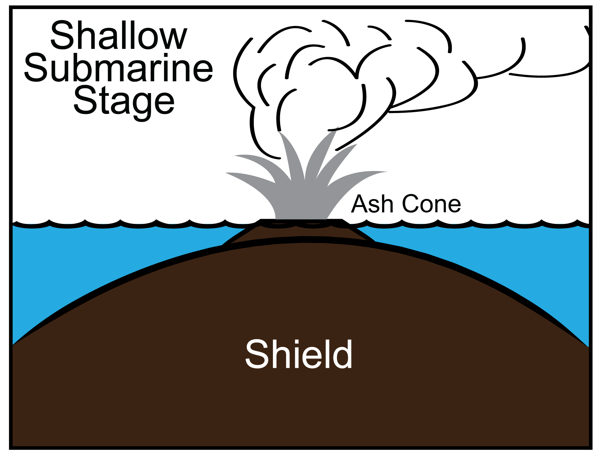
Shallow submarine stage of volcanic island formation. Modified from a diagram by Andrielle Swaby, originally published in The Teacher-Friendly Guide to the Geology of the Western US.
3. Subaerial shield-building stage
The submarine and subaerial shield-building stages are the main constructive phases of Hawaiian volcanism. By the time the volcano has emerged above sea level, the lavas have undergone a change in chemistry. Movement over the center of the hot spot produces lavas with fewer alkali elements and more silicates, creating tholeiitic basalt, the second major type of Hawaiian lava. This highly fluid lava erupts voluminously over 0.5 to 1 million years, continuing to build a classic shield-shaped volcano.
These volcanoes erupt from shallow magma reservoirs located a few kilometers beneath their summits, and also from radial rift zones that channel magma lower onto the flanks of the active volcano. High-volume eruptions that rapidly empty the magma reservoir often lead to summit collapse and the formation of a volcanic caldera, the large, steep-walled crater that crowns many shield volcanoes. While a summit caldera is characteristic of the shield-building stage, some volcanoes do not appear to have one (for example, Hualālai, West Moloka'i), and the well-developed summit caldera on Lō'ihi shows that caldera formation may also occur earlier in the lifecycle of a volcano. Mauna Loa and Kīlauea, which both have large summit calderas, are examples of volcanoes in the subaerial shield-building stage.
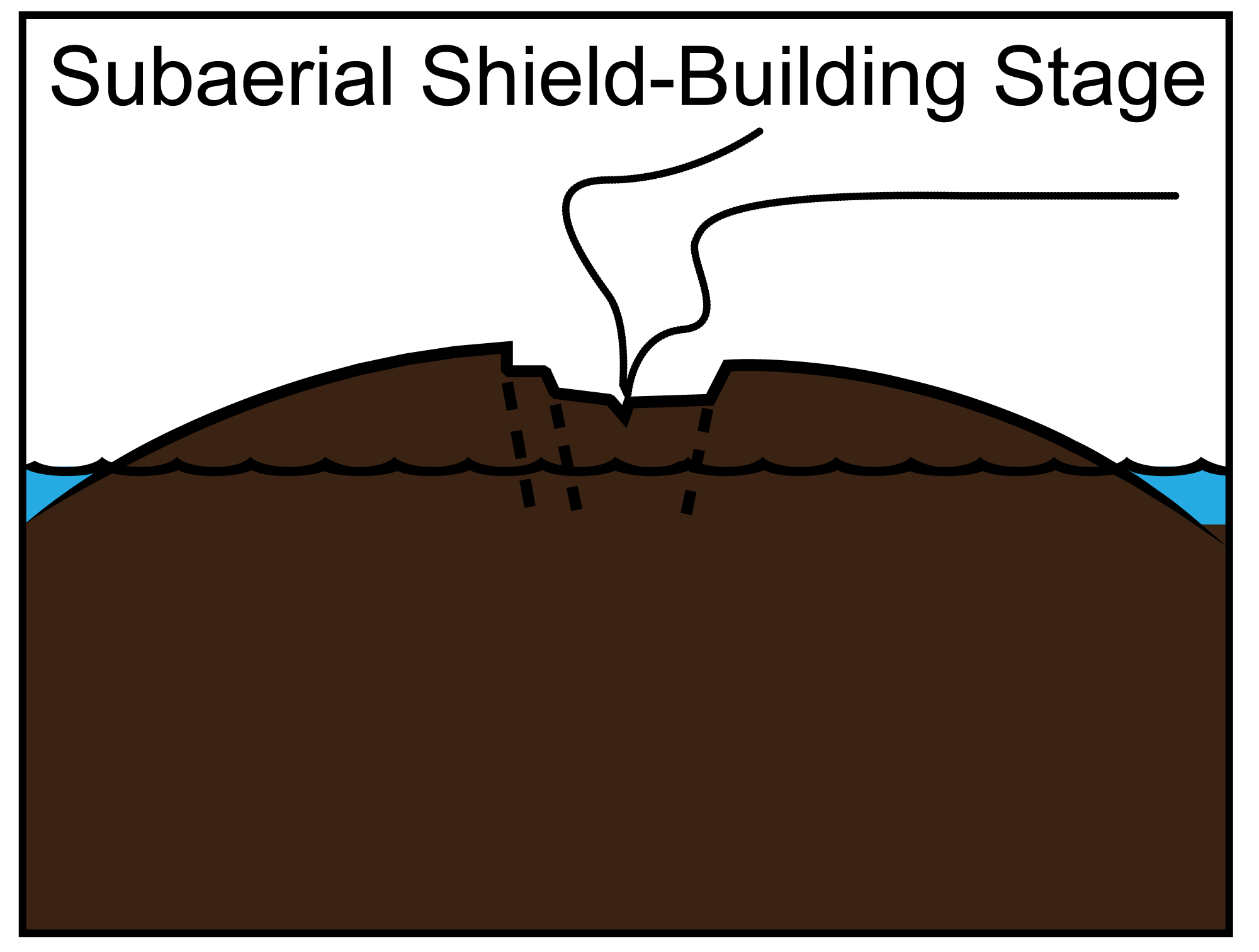
Subaerial shield-building stage of volcanic island formation. Modified from a diagram by Andrielle Swaby, originally published in The Teacher-Friendly Guide to the Geology of the Western US.
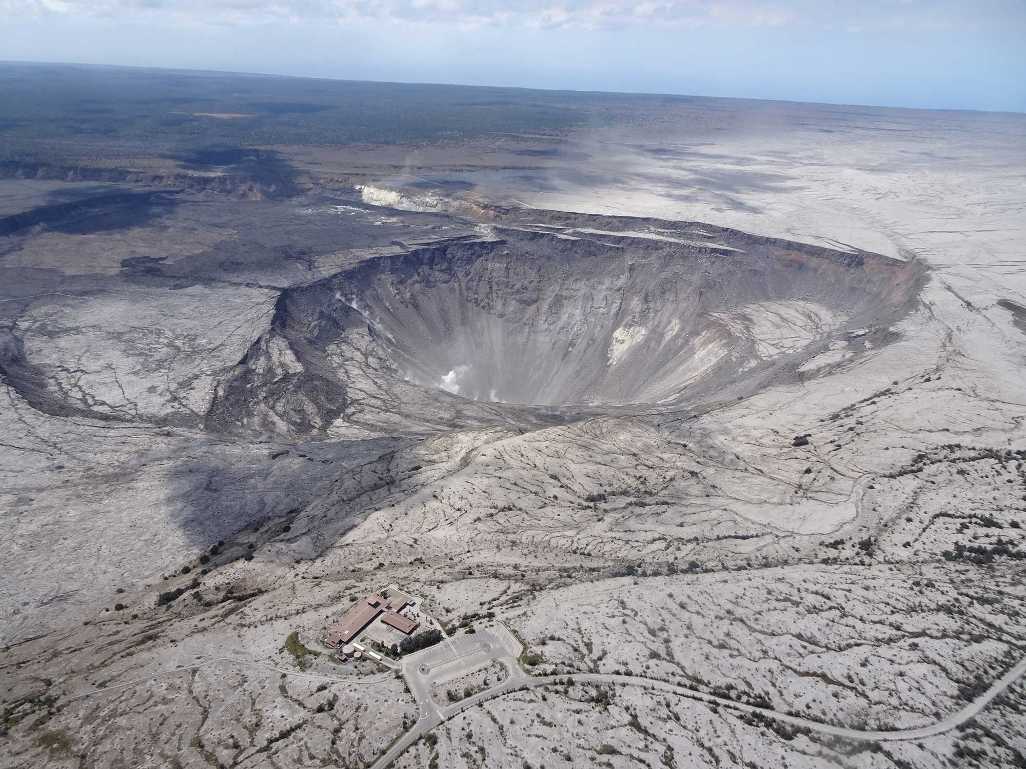
Summit caldera of Kīlauea showing Halema'uma'u crater, Hawai'i Island, July 13, 2018. The Jagger Museum is in the foreground (the building and parking area at the bottom-center of image). In 2018, earthquakes caused by volcanic activity on Kīlauea severely damaged the museum, and it had to be closed. It is possible that the existing building will never be reopened. Source: USGS photo (Hawaii Volcanoes National Park on flickr, public domain).
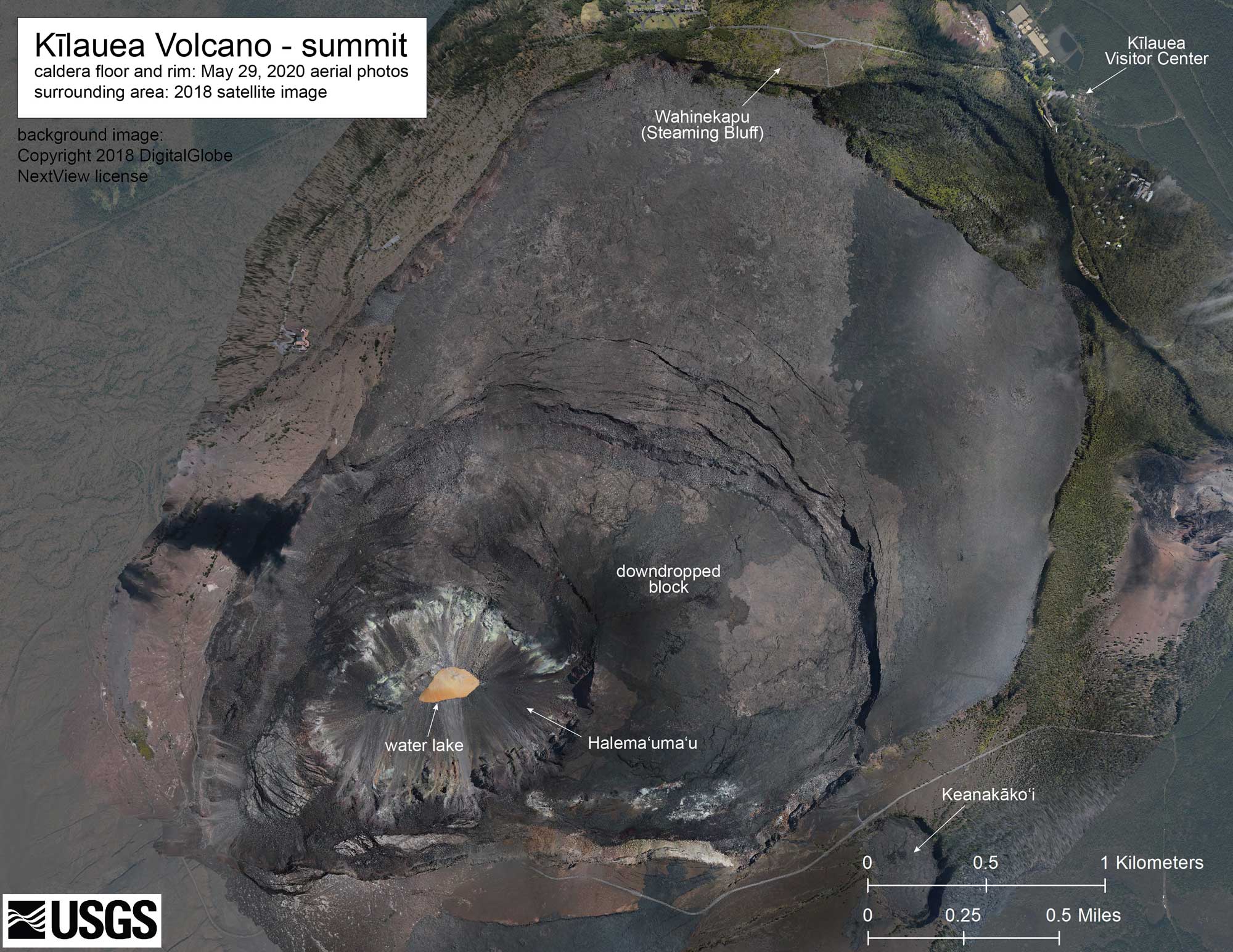
Kīlauea summit caldera and Halema'uma'u crater, Hawai'i Island, composite of images from 2018 and 2020. A portion of Crater Rim Drive, a drive that used to encircle Kīlauea crater, was destroyed in 2018. Source: Katherine Mulliken, USGS HVO (public domain).
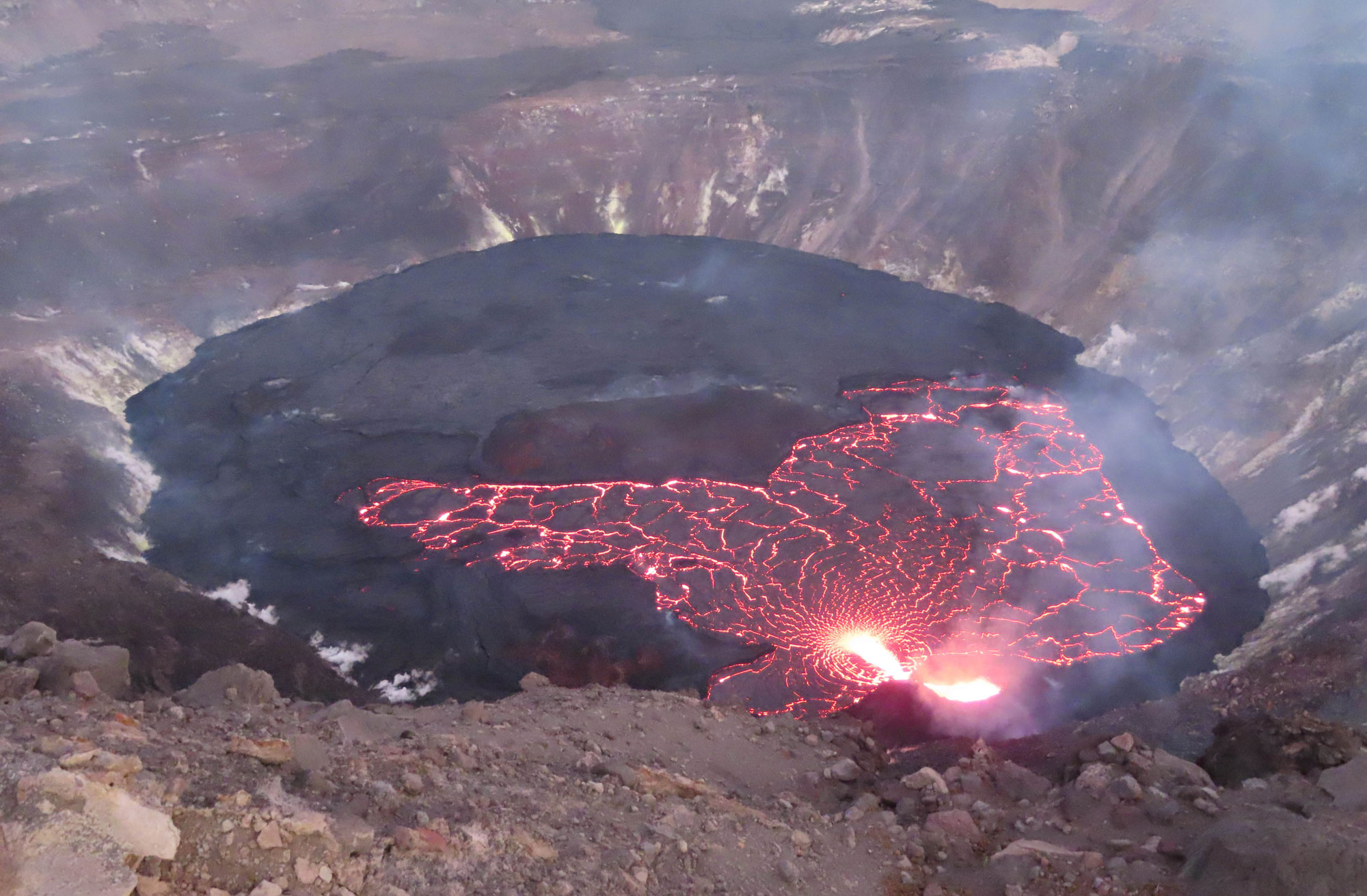
Lava lake, Halema'uma'u crater, Kīlauea volcano summit caldera, Hawai'i Island, November 2, 2021. Source: Julie M. Chang, USGS (public domain).
4. Post-caldera stage
Most summit calderas are eventually filled and buried by continuing eruptions of tholeiitic lavas. As the volcano moves away from the center of the hot spot, the eruptions change composition again, returning to alkalic basalt. These later eruptions cap the older shield, and their slightly more explosive nature gives rise to lava fountains that produce cinder cones on the summits and flanks of the volcanoes. These cones give older volcanoes a bumpy profile, in contrast to the smooth, younger shield.
Alkalic cap lavas often contain numerous phenocrysts. Phenocrysts are early-formed crystals that are entrained in the magma as it erupts. The growth of crystals changes the composition of the remaining liquid magma, and late-stage eruptions can sometimes produce unusual lavas that are so silica-rich they are no longer called basalts. Mauna Kea and Hualālai are in the post-caldera stage, and the Pu'u Wa'awa'a cinder cone on Hualālai's north flank produces high-silica eruptions called trachyte.
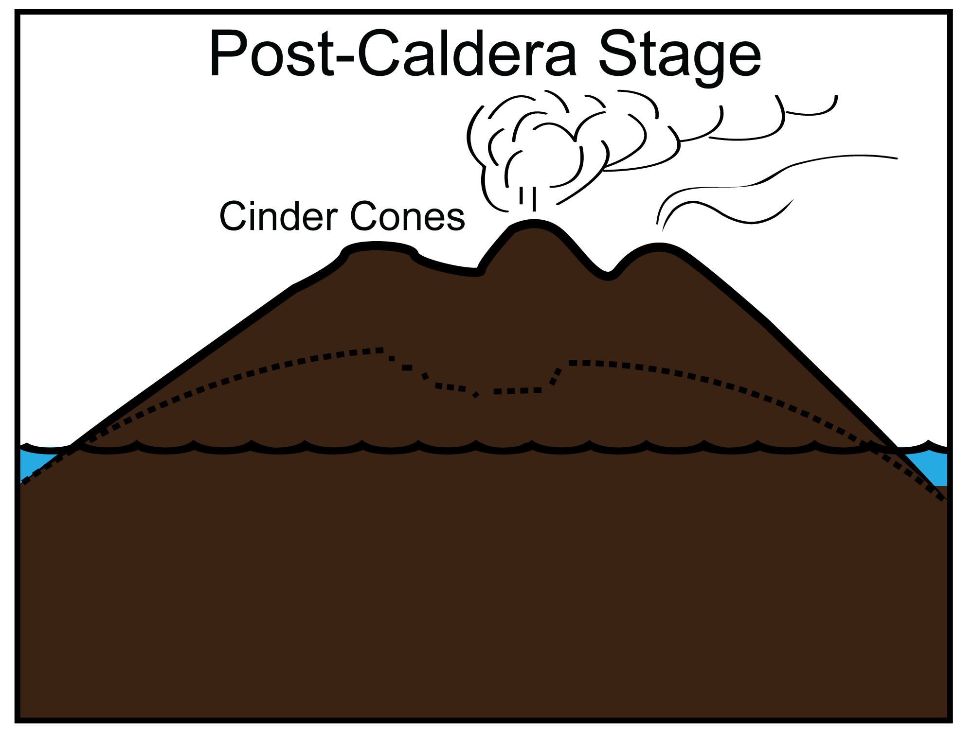
Post-caldera stage of the volcanic island lifecycle. Modified from a diagram by Andrielle Swaby, originally published in The Teacher-Friendly Guide to the Geology of the Western US.
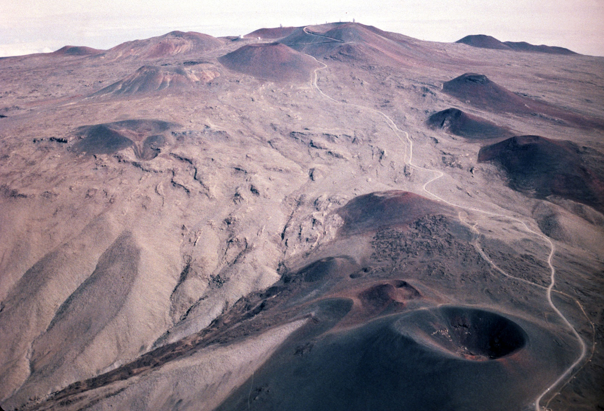
Cinder cones on the south flank of Mauna Kea, Hawai'i Island. These cones are 70,000 and 4,000 years old. Photo: USGS (public domain).
Cinder cones on Haleakalā, Maui. Photo "Haleakalā Cinder Cones" by Eric Tessmer (flickr, Creative Commons 2.0 Generic license, image resized).
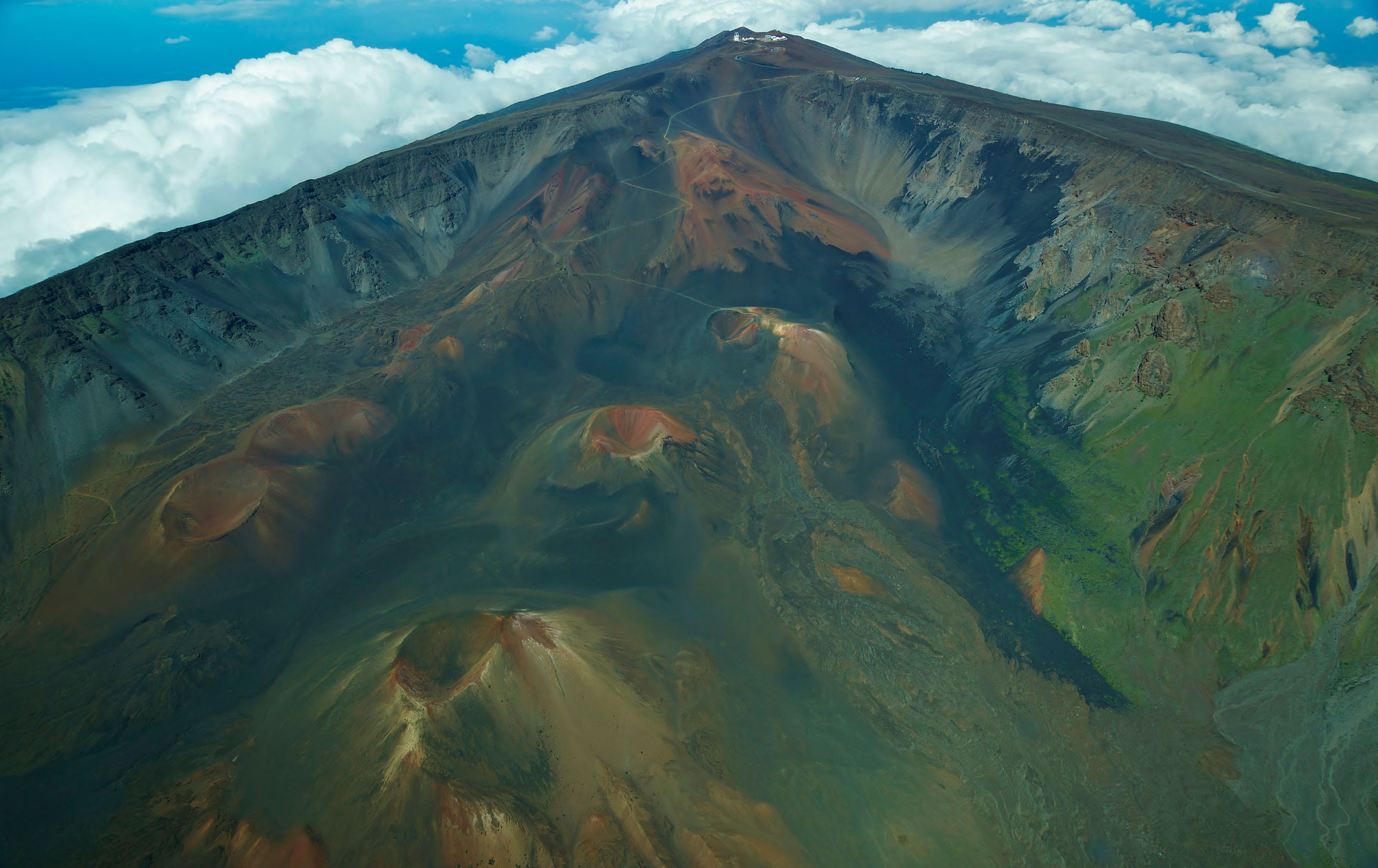
5. Erosional stage
While the first four stages in the volcanic lifecycle are predominantly constructional, it is important to recognize that erosional processes begin as soon as a volcano rises above the sea floor. Submarine landslides that drape the flanks of Kama'ehuakanaloa (Lō'ihi) and prominent fault scarps (pali in Hawaiian) on Kīlauea and Mauna Loa are evidence that even young volcanoes begin to experience gravitational collapse.
Once eruptive activity slows, erosion and weathering become the dominant forces in shaping the evolution of the islands. Soils form, and streams, which are absent on very young volcanoes, begin to incise the surface of the shield.
Hawaiian volcanoes are also subject to episodic, catastrophic, erosional events, when mega-landslides rip apart the unsupported seaward flanks of the islands. These landslides scatter enormous blocks of material for hundreds of kilometers (miles) across the seafloor and generate tsunamis with local run-up heights up to 300 meters (980 feet) above sea level. Kohala and Haleakalā are examples of erosional stage volcanoes.
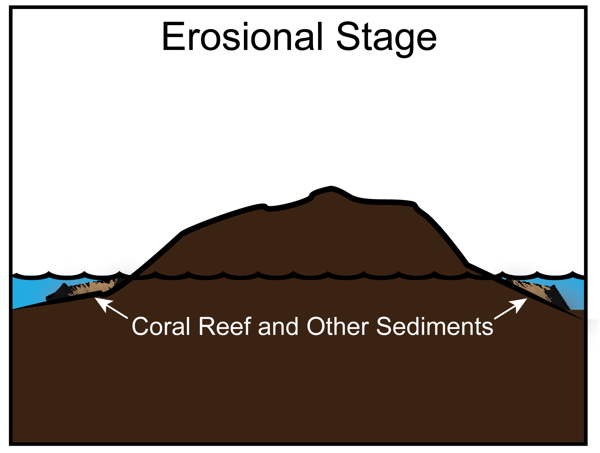
Erosional stage of the volcanic island lifecycle. Modified from a diagram by Andrielle Swaby, originally published in The Teacher-Friendly Guide to the Geology of the Western US.
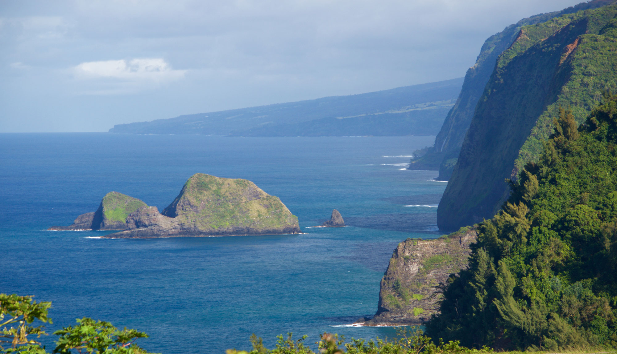
Cliffs on windward Kohala, Hawai‘i Island, viewed looking southeast from Pololū valley. Most Hawaiian sea cliffs are the head scarps of mega-landslides. Photo "Coastline off pololu Valley, Kohala Forest Reserve . . ." by Bill Abbott (flickr, Creative Commons Attribution-ShareAlike 2.0 Generic license, image resized).
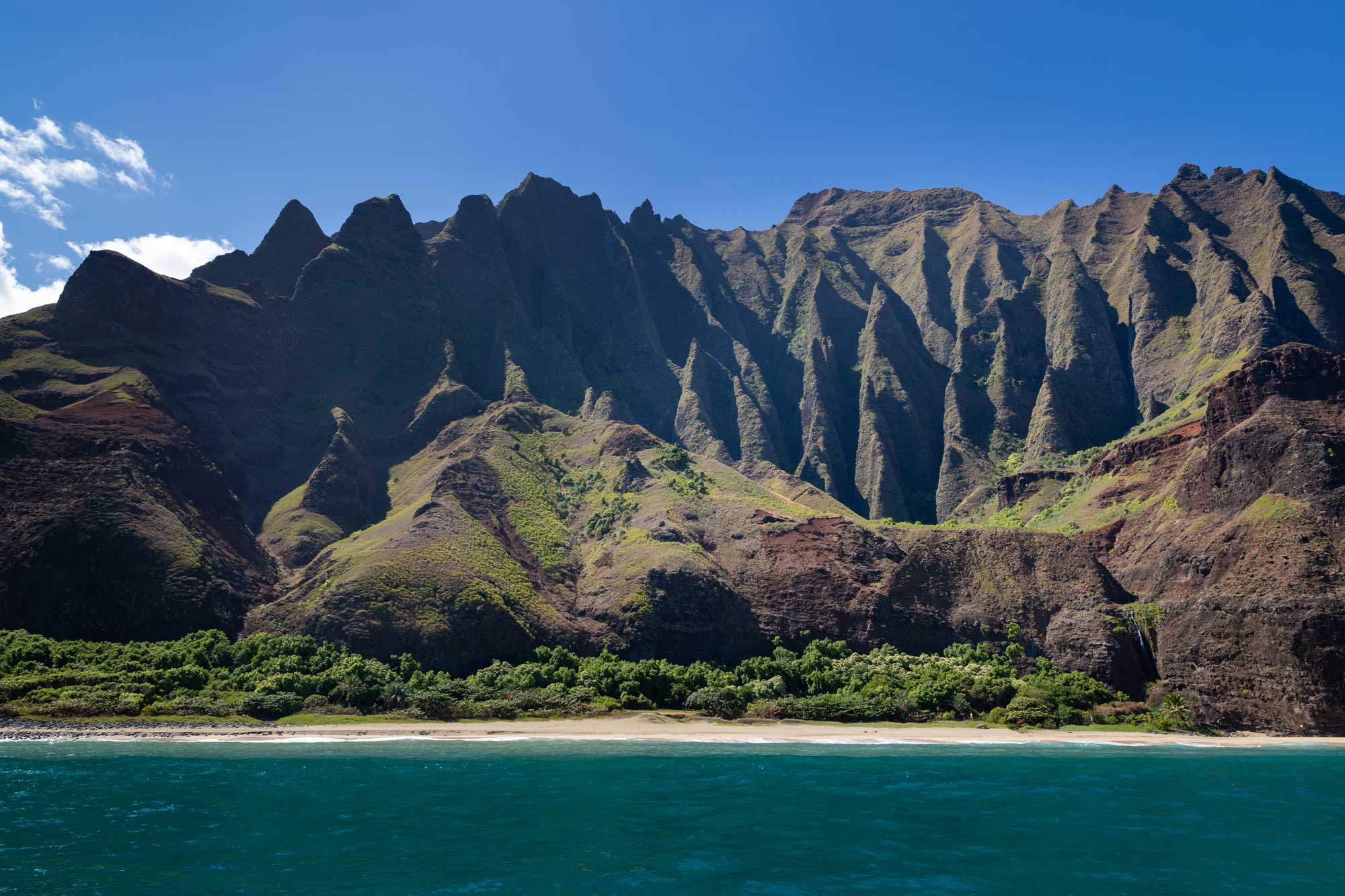
Weathered slopes, Na Pali Coast, Kaua'i. Photo by dronepicr (flickr, Creative Commons Attribution 2.0 Generic license, image resized).
6. Reef-building stage
Hawai'i's tropical latitude permits the growth of reef-building corals. The reefs are found principally on the leeward side of each island where there is little river runoff and thus very clear water. Many of these corals live at or near sea level, making the reefs excellent indicators of sea level rise and fall. As the islands age, the coral reefs expand, eventually encircling each island. Volcanoes as young as Mauna Loa are host to incipient reefs, while the older islands of O'ahu and Kaua'i have extensive, well-developed fringing reefs.
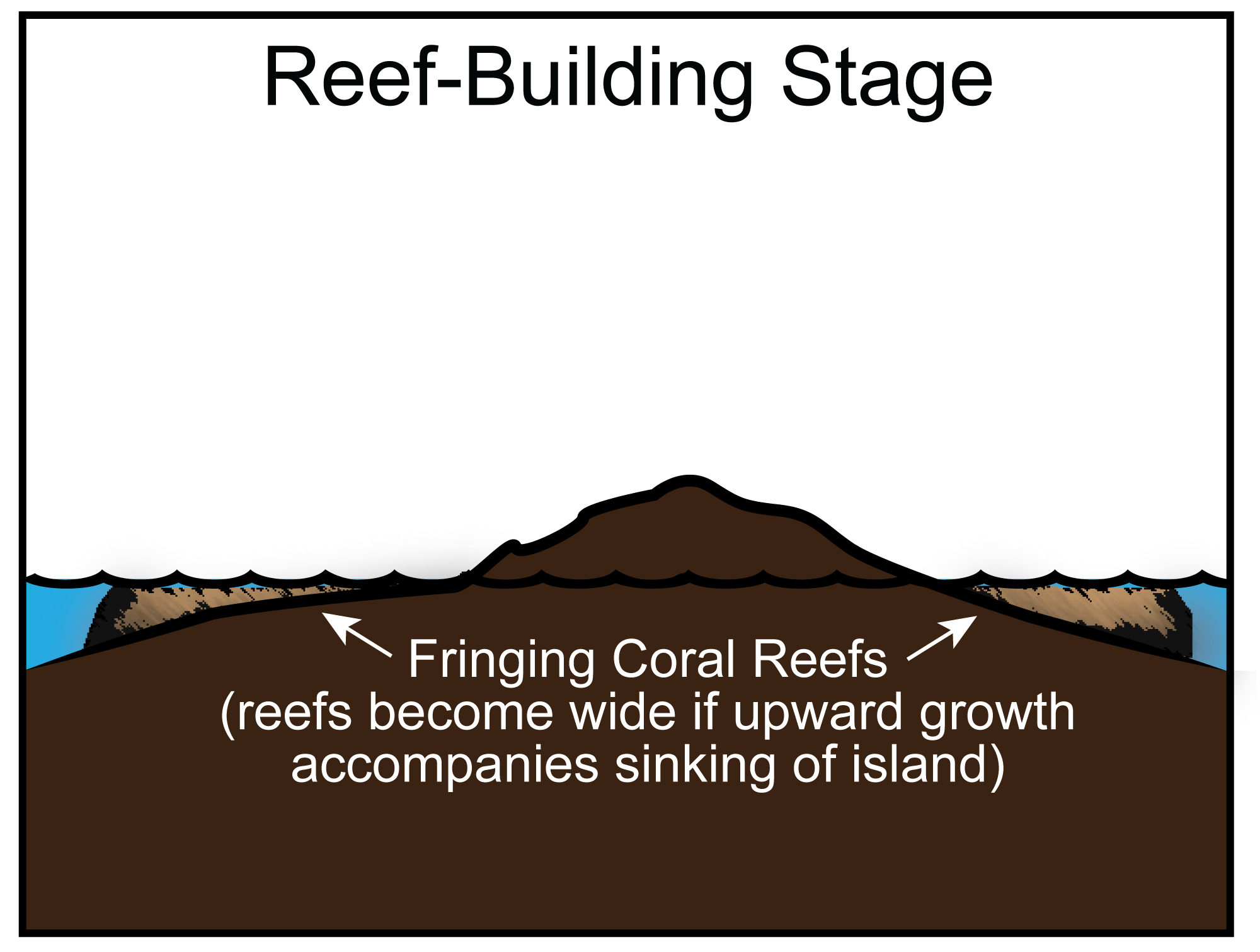
Reef-building stage of the volcanic island lifecycle. Modified from a diagram by Andrielle Swaby, originally published in The Teacher-Friendly Guide to the Geology of the Western US.
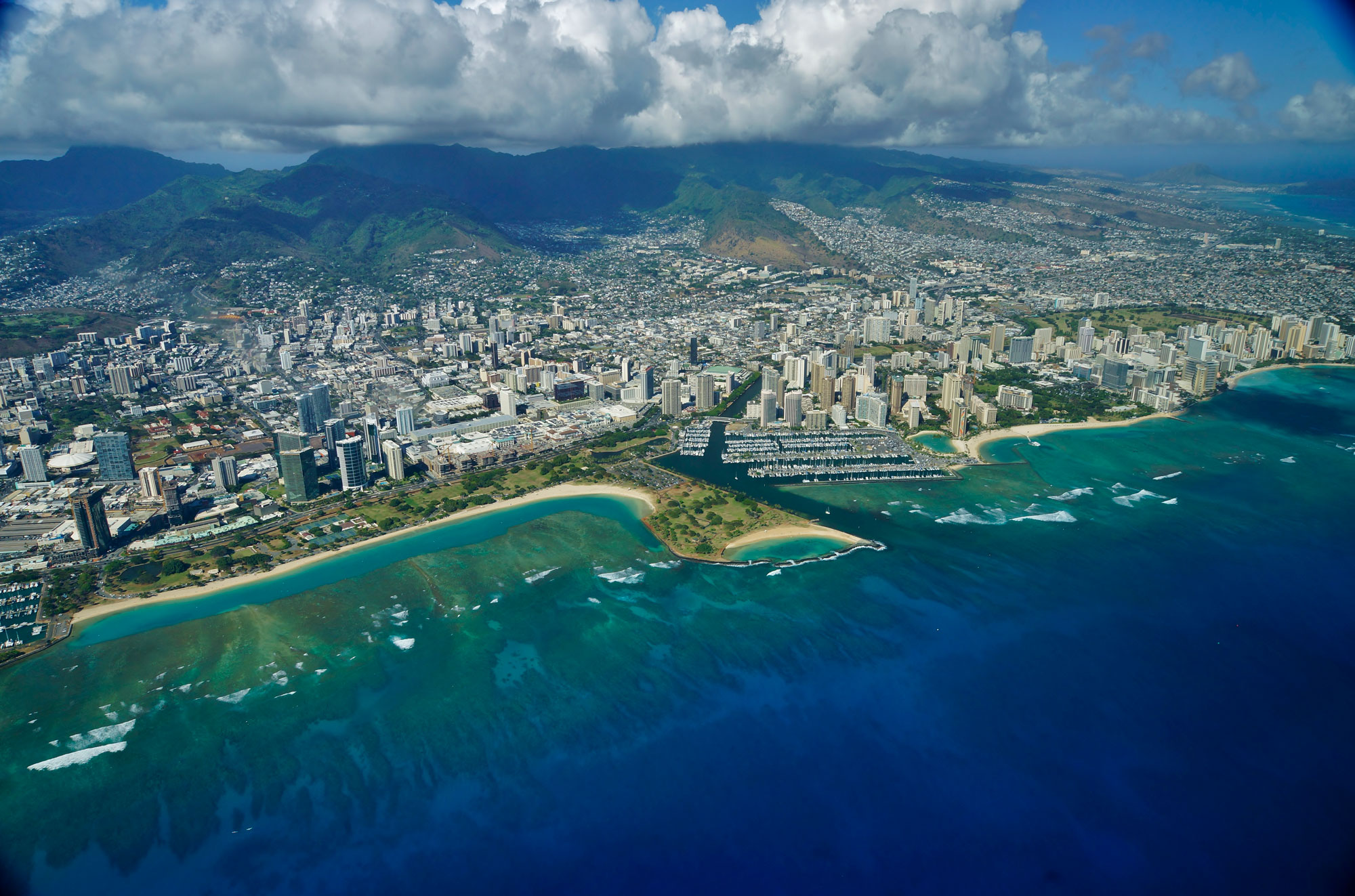
Coral reefs off Waikiki, O'ahu. Photo "Ala Moana and Waikiki" by Eric Tessmer (flickr, Creative Commons 2.0 Generic license, image resized).
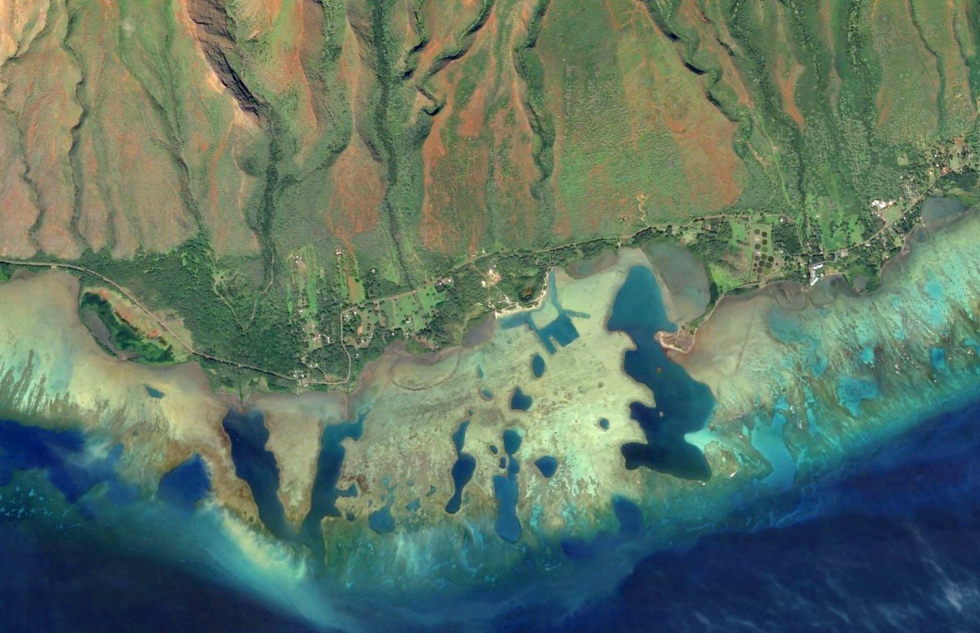
Coral reefs off the coast of Kamalo, Moloka'i. Source: USGS (public domain).
7. Rejuvenated post-erosional eruptions
After a long period of quiescence, most Hawaiian volcanoes experience a final episode of eruptive activity. This rejuvenated stage typically produces cinder cones and associated volcanic ash deposits. Many of the cinder cones are located near the shoreline. One hypothesis for the origin of these late-stage eruptions is that mass loss due to erosion decompresses the magma below, triggering further melting and eruption. Rejuvenated volcanism is found on all islands except Hawai'i.
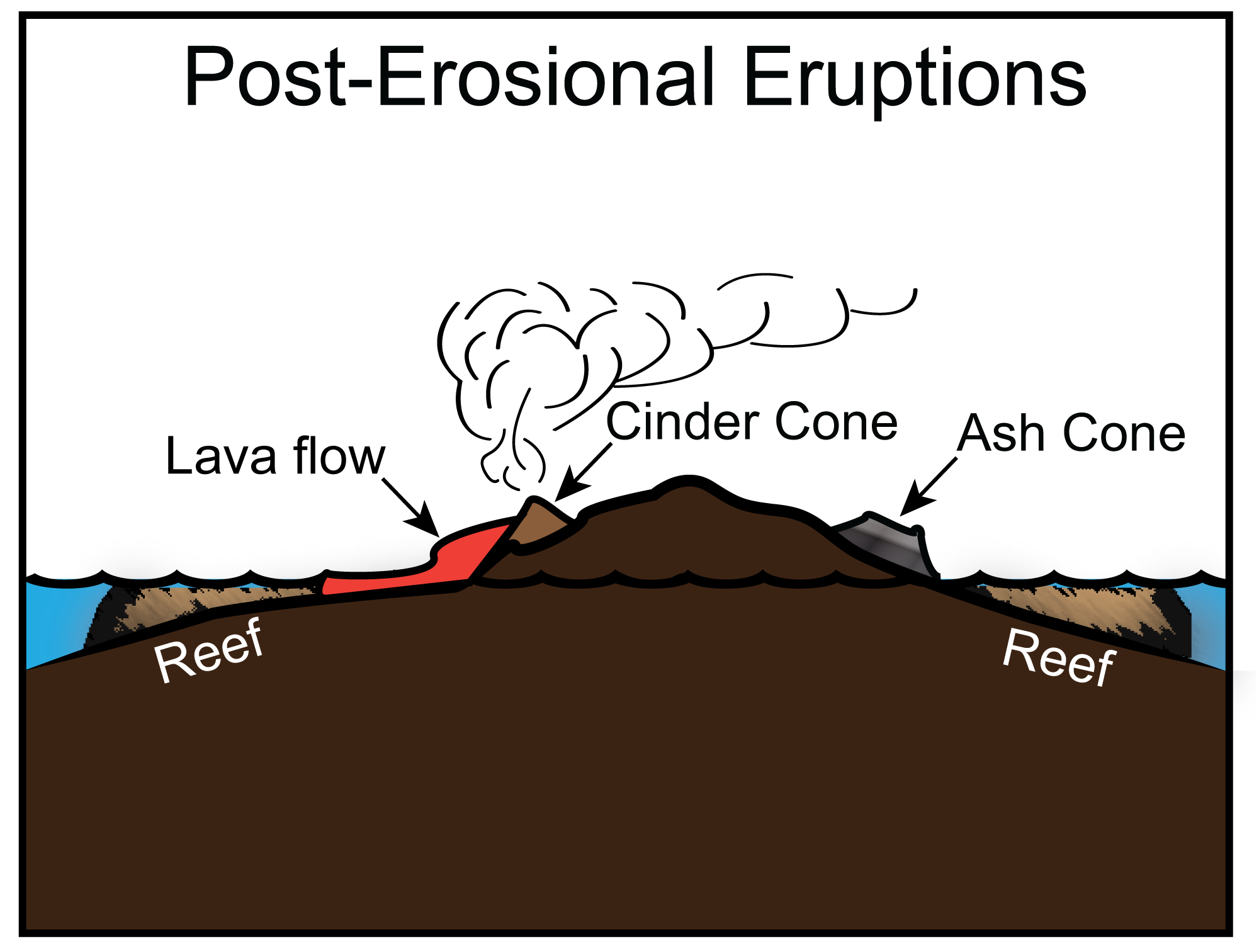
Rejuvenated post-erosional eruption stage of the volcanic island lifecycle. Modified from a diagram by Andrielle Swaby, originally published in The Teacher-Friendly Guide to the Geology of the Western US.
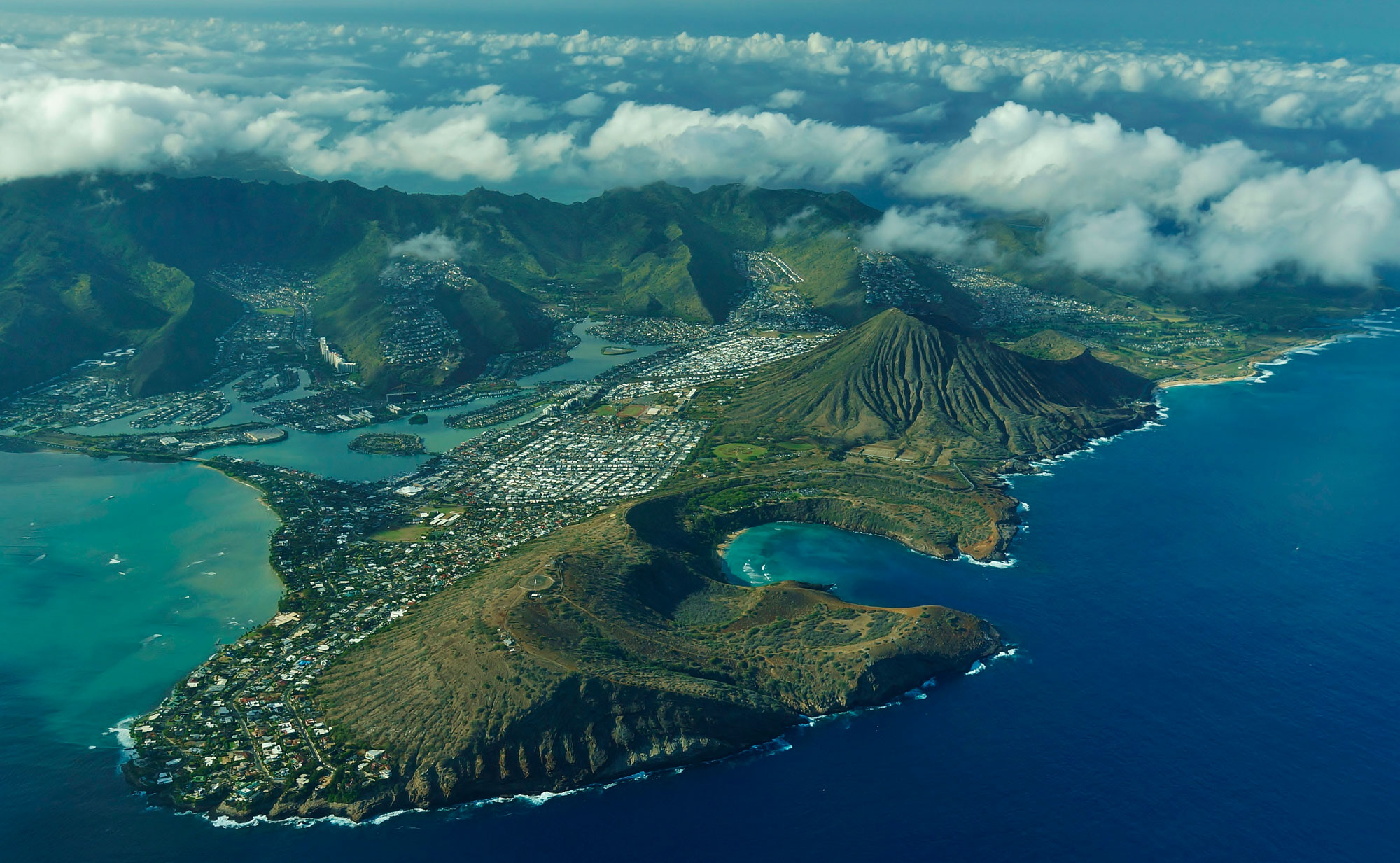
Volcanic craters formed by rejuvenated volcanism on O'ahu, including Hanauma Bay (foreground) and Koko Crater (immediately behind Hanauma Bay). Photo "Hanuama Bay and Koko Crater Hawaii Kai" by Eric Tessmer (flickr, Creative Commons Attribution 2.0 Generic license, image cropped and resized).
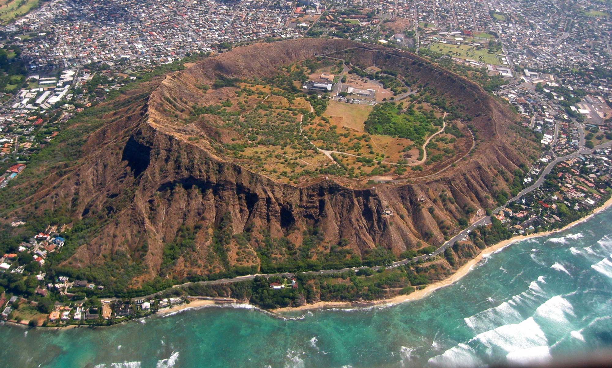
Diamond head, a volcanic crater formed by rejuvenated volcanism on O'ahu. Photo "Diamond Head East Aerial View, Waikiki and Honolulu Hawaii, Summer" by Eric Tessmer (flickr, Creative Commons Attribution 2.0 Generic license, image resized).
8. Atoll stage
As the volcanoes drift farther from the hot spot, they cool and eventually become extinct. The lithosphere on which the islands sit also cools, becoming denser. The volcanic ridge gradually subsides, causing the islands to slowly sink. As subsidence drags the islands down, erosion by waves, streams, and mass wasting works to diminish the islands from above. Fringing reefs expand to encircle the eroded volcano. Ultimately, the volcanic edifice is eroded to sea level and only the circular reef remains, forming an atoll. Many of the northwestern Hawaiian Islands are in the atoll stage.
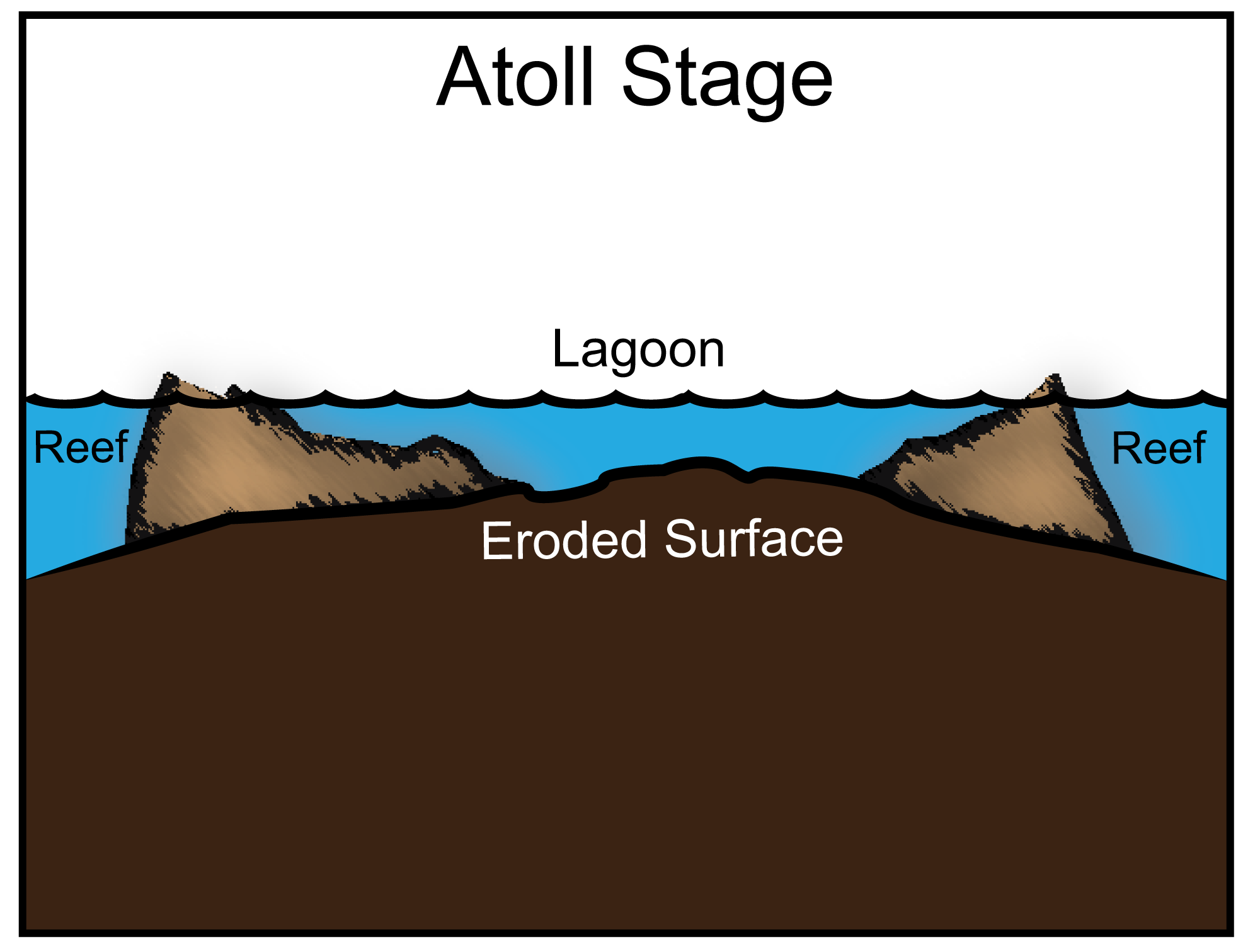
Atoll stage of the volcanic island lifecycle. Modified from a diagram by Andrielle Swaby, originally published in The Teacher-Friendly Guide to the Geology of the Western US.
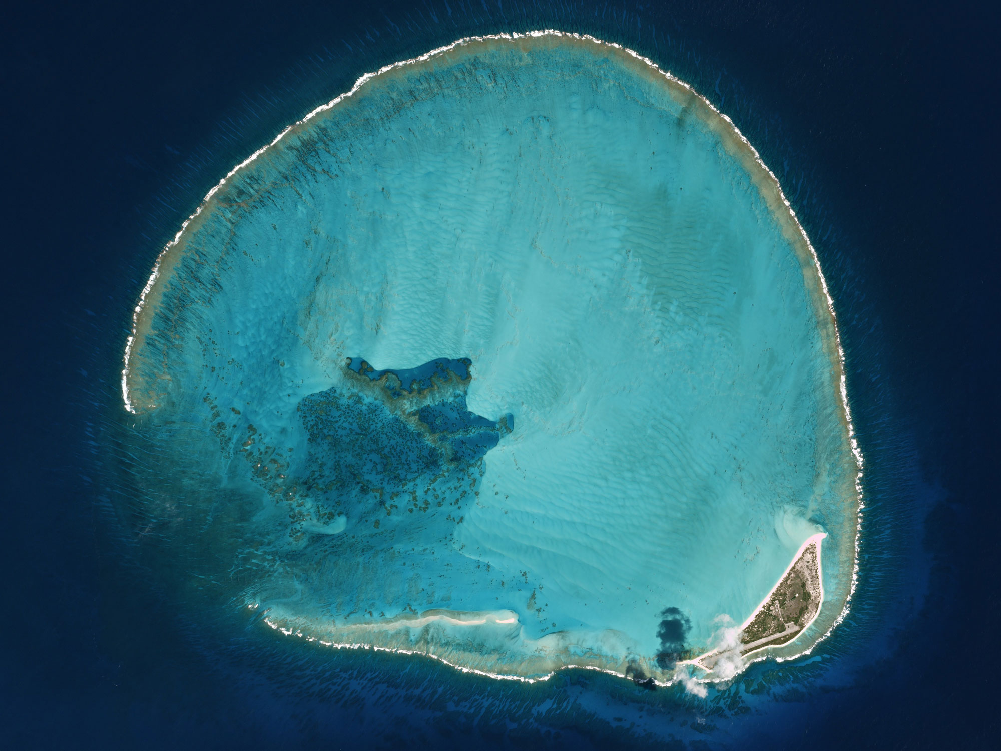
Kure Atoll, northern Hawaiian Islands. Source: Volcano Hazards, USGS.
9. Guyot Stage
Continued subsidence pulls even the coral atolls below sea level. Eventually, the living coral reefs literally “drown,” becoming flat-topped seamounts called guyots. The Emperor Seamounts exemplify this final stage in the lifecycle of Hawaiian volcanoes. Ultimately, each of the Emperor Seamount and Hawaiian islands will return to the mantle via subduction at an active plate boundary, millions of years in the future.
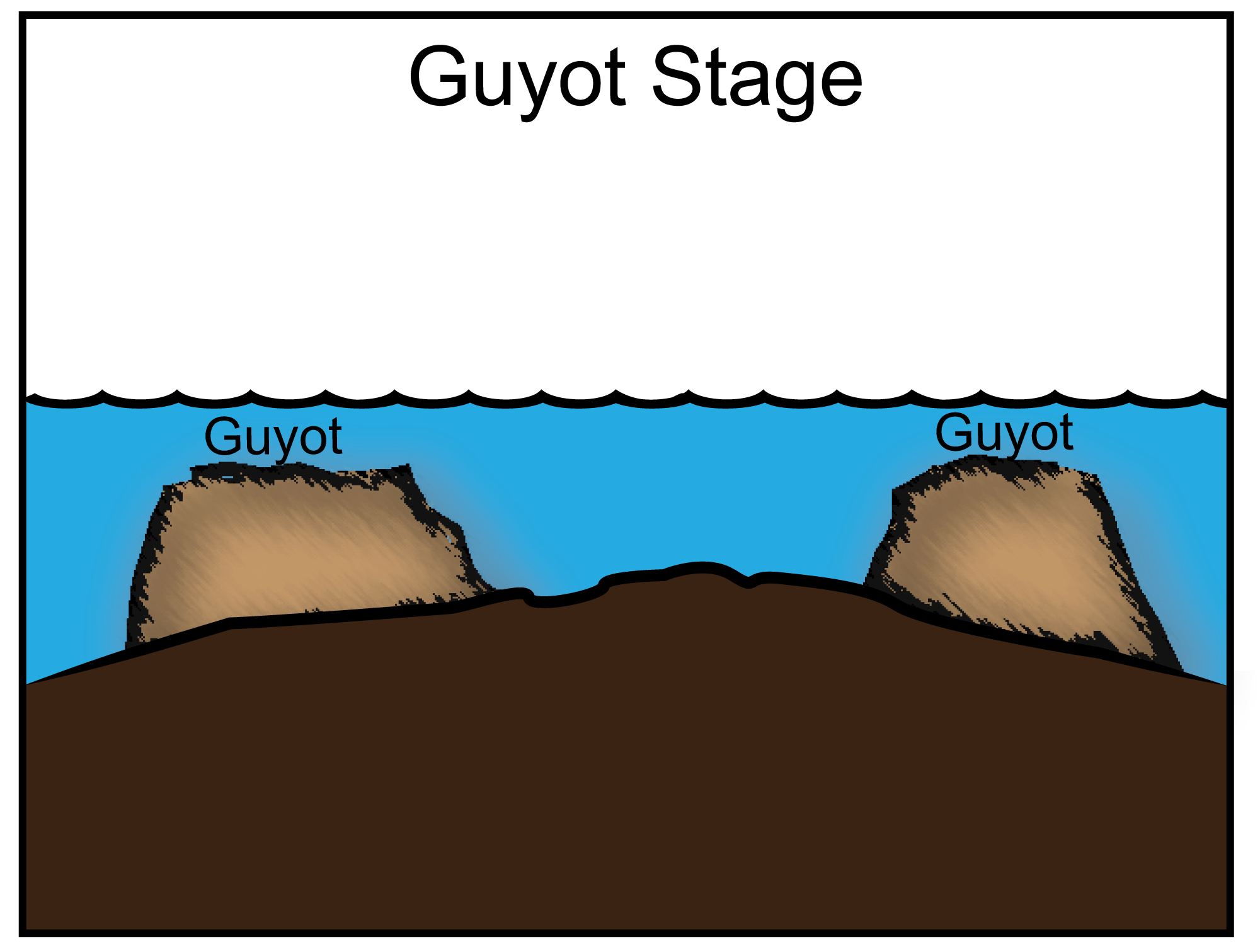
Guyot stage of the volcanic island lifecycle. Modified from a diagram by Andrielle Swaby, originally published in The Teacher-Friendly Guide to the Geology of the Western US.
Hot spot volcanoes and Hawaiian tradition
Some changes that occur as hot spot volcanoes evolve through their lifecycle—for example, the transition from alkalic to tholeiitic lavas—are evident only by conducting chemical tests. But many other changes are visible to the naked eye. Smooth volcanic shields are dissected by erosion, large canyons are carved through the landscape, and the size of the islands decreases with increasing age.
The original inhabitants of the Hawaiian Islands were acute observers of nature. Their survival in the isolated islands depended on their understanding of natural phenomena, and their cosmology reflected what they saw in the world around them. The ancient Hawaiian story of Pele, the goddess of fire and volcanoes, describes her arrival on the islands of Kaua'i and Ni'ihau: the oldest of the eight main Hawaiian Islands. Pele found these islands to be unsuitable for her fiery temperament, as they were dominated by her sibling rival, Nāmaka, goddess of the ocean.
Pele traveled to O'ahu, the next youngest island, but here too she could not escape the influence of her sister. Pele moved from island to island, to Moloka'i, Lāna'i, and on to Maui, where she thought she might be safe. But she was forced to flee even from the giant volcano Haleakalā, coming at last to Hawai'i Island and Kīlauea. On Kīlauea she searched the earth with her digging stick and found a fire that Nāmaka could not extinguish. Here, within the youngest volcano, Pele made her home. This oral tradition accurately reflects the age progression of Hawaiian volcanoes, passing along the islands’ geologic history through a colorful narrative.
Pele's hair, a hair-like form of volcanic glass, near Halema'uma'u Crater, Kīlauea Volcano, Hawai'i Island. Photo by USGS (public domain).
Resources
Earth@Home: Here on Earth: Introduction to Plate Tectonics: https://earthathome.org/hoe/plate-tectonics