

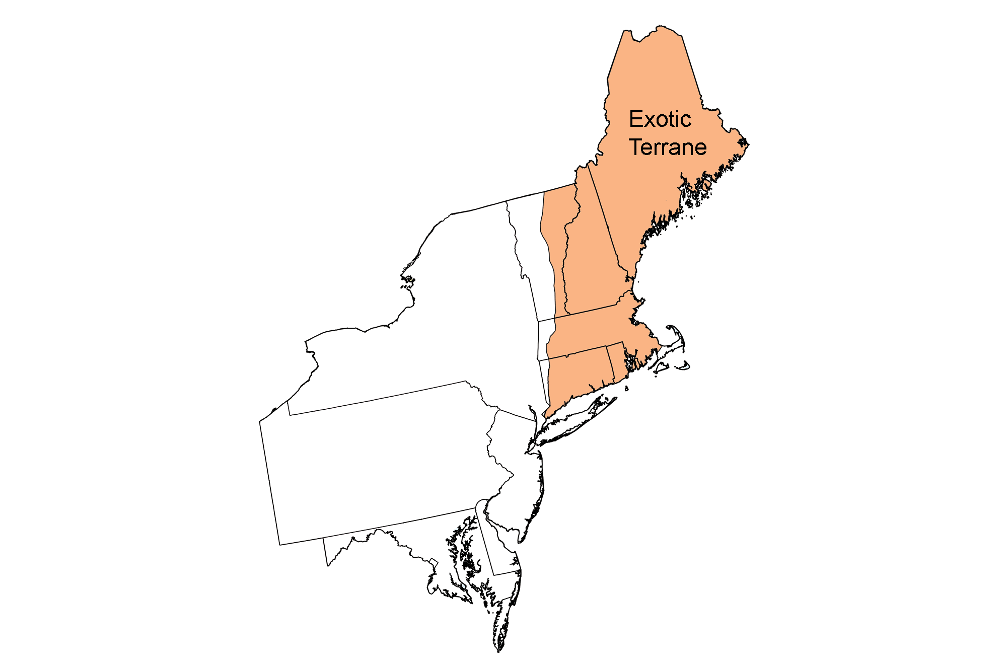
Snapshot: Overview of the topography of the Exotic Terrane region of the northeastern United States.
Topics covered on this page: New England Uplands; New England Coastal Lowlands; New England Basins; Resources.
Credits: Most of the text of this page is derived from "Topography of the Northeastern US: the BIG picture" by Jane E. Ansley, chapter 5 in The Teacher-Friendly Guide to the Geology of the Northeastern U.S. (published in 2000 by the Paleontological Research Institution). The book was adapted for the web by Elizabeth J. Hermsen and Jonathan R. Hendricks in 2020–2023. Changes include formatting and revisions to the text and images. Credits for individual images are given in figure captions.
Updates: Page last updated September 26, 2023.
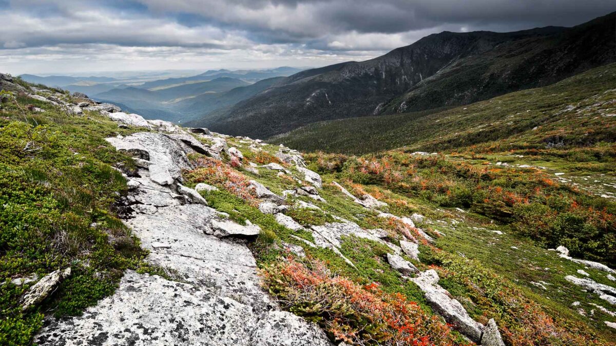
Image above: Mount Washington, New Hampshire, the highest point of elevation east of the Mississippi River. Photograph by "weesam2010" (Flickr; Creative Commons Attribution-NonCommercial-ShareAlike 2.0 Generic license; image cropped and resized).
New England Uplands
Much of the Exotic Terrane region is simply classified as the New England Uplands. The region is characterized by rolling hills and valleys, and mountainous terrain. The Uplands include the mountainous terrain of the mountains of Maine, the White Mountains, the Bolton Range and the Mohegan Range.
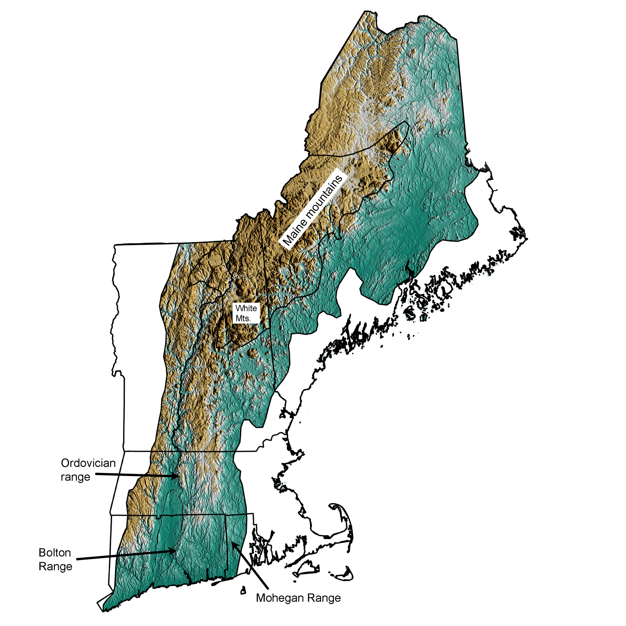
The New England Uplands region of the Exotic Terrane; greens indicate lower elevation, browns higher elevation. Topographic data derived from the Shuttle Radar Topography Mission (SRTM GL3) Global 90m (SRTM_GL3) (Farr, T. G., and M. Kobrick, 2000, Shuttle Radar Topography Mission produces a wealth of data. Eos Trans. AGU, 81:583-583.). Image created by Jonathan R. Hendricks for the Earth@Home project.
The mountains of the Exotic Terrane region were formed over the last billion years from a variety of rock types: Ordovician-age igneous intrusions related to the Taconic mountain-building event; Ordovician volcanic rocks from the Taconic volcanic islands; Devonian-age intrusions related to the Acadian mountain-building event; Jurassic-age intrusions; and metamorphosed Silurian and Devonian sedimentary rock that originated as seafloor sediments in the Iapetus Ocean.
The mountains of Maine stretch in a belt from the high peaks of the southwest to central Maine. The mountains are generally higher in the southwestern part of the state. Mt. Katahdin in central Maine is an exception; made of an unusually resistant granite from an Acadian mountain-building igneous intrusion, it is the highest peak in Maine at 1605 meters above sea level. During the Acadian mountain-building event, intense metamorphism of the rocks in southeastern Maine and the highly resistant volcanic rocks of the area created the Maine mountains. Further north in Maine, the rocks were subjected to less metamorphism. There are fewer ridges in this region because the rocks are less resistant to weathering and erosion.
The White Mountains of New Hampshire include the Presidential Range, the Franconia Mountains, and the hills of northern New Hampshire and northeastern Vermont. Igneous intrusions from the Taconic and Acadian mountain-building event, as well as volcanics from a possible hot spot during the Jurassic, form many of the peaks of the White Mountains. Some of the highest peaks of the range, however, are formed from Devonian schist, including Mt. Washington, at nearly 1900 meters above sea level.
Ordovician igneous intrusions and volcanic rocks from the Taconic mountain-building event form a narrow range of resistant mountains. The Ordovician ranges begin in Connecticut as the Bolton Range, and extend north to New Hampshire and Maine, where the Ordovician-age rocks intermingle with rocks of other ages to form the Maine and New Hampshire mountains.
The Mohegan Range, a series of north-northeast ridges in Connecticut and Rhode Island, was carved from one of the Exotic Terranes. The microcontinent Avalonia, which was sutured to North America during the Devonian, had Precambrian bedrock exposed in certain places at the surface. This resistant, Precambrian rock became the Mohegan Range through weathering and erosion of surrounding less-resistant rocks.
Unusual features of the Uplands topography include knobs of resistant rock that stick out high above the relief of the local landscape. These are known as monadnocks, the most famous example of which is Mt. Monadnock in New Hampshire. Throughout New Hampshire and northern Vermont, isolated mountains of resistant rock stick up above the local landscape, left standing after erosion of less-resistant surrounding rock.
New England Coastal Lowlands
The Coastal Lowlands of the New England Exotic Terrane region are a discontinuous swath of land along the coastline from Maine to Connecticut that has a lower elevation than the rest of the Exotic Terrane region.
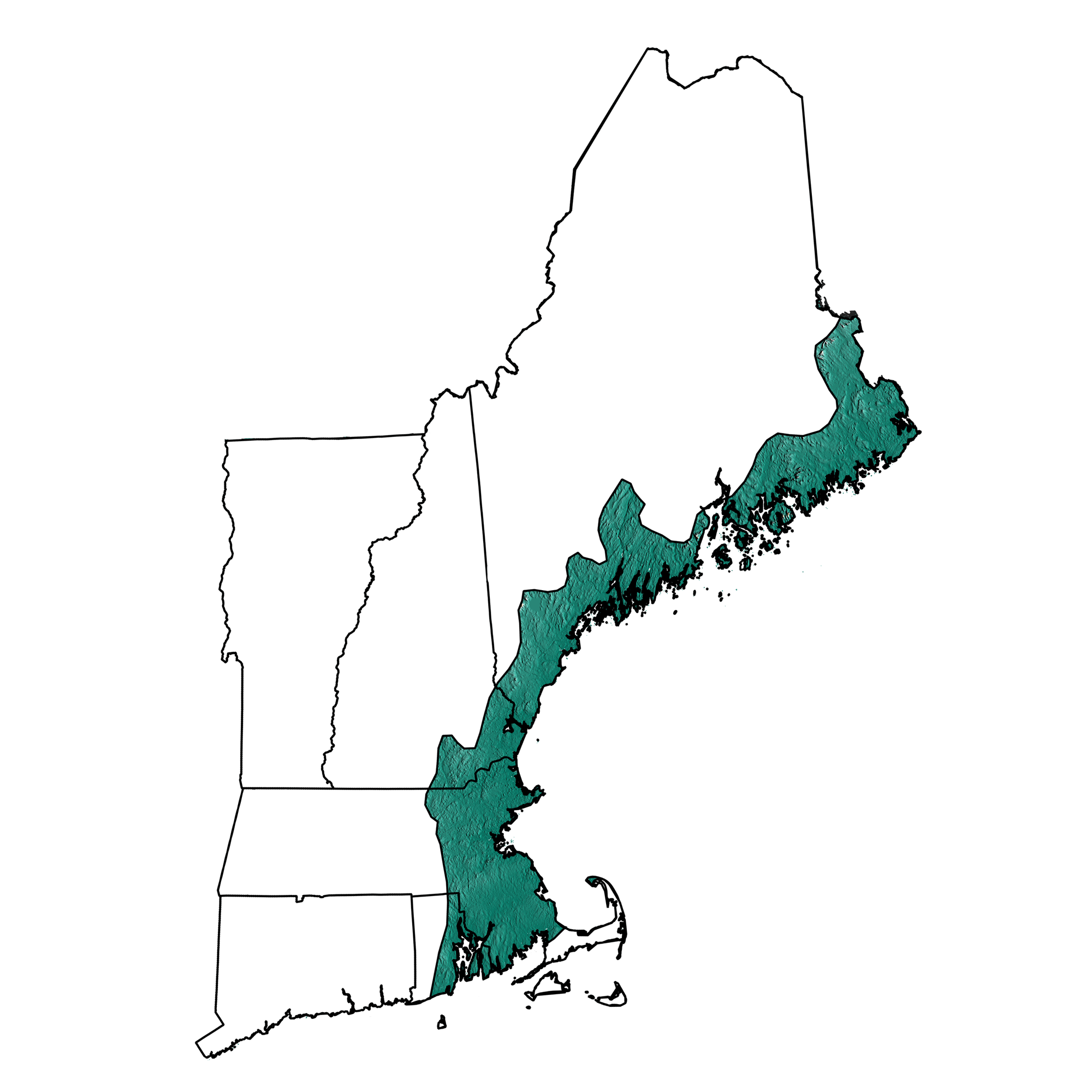
The New England Coastal Lowlands region of the Exotic Terrane; greens indicate lower elevation, browns higher elevation. Topographic data derived from the Shuttle Radar Topography Mission (SRTM GL3) Global 90m (SRTM_GL3) (Farr, T. G., and M. Kobrick, 2000, Shuttle Radar Topography Mission produces a wealth of data. Eos Trans. AGU, 81:583-583.). Image created by Jonathan R. Hendricks for the Earth@Home project.
The lower elevations of the Coastal Lowlands area are not due to softer, less-resistant rock types or the structure of the rocks. The glaciers of the last ice age depressed the crust of the Northeast somewhat. When the continental ice sheet began to retreat back north and melt, the crust rebounded from the removal of the heavy weight of the glaciers. However, the crust could not rebound before the melting glaciers raised sea level high enough to flood much of the coastal portion of New England. Submergence and erosion by wave action are the cause of lower elevations in the Coastal Zone area of New England.
The New England coast is famous for its rocky shoreline.
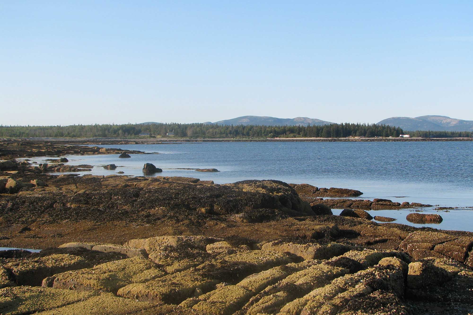
Rocky shoreline at Acadia National Park. Photograph by Matt Tillett (Flickr; Creative Commons Attribution 2.0 Generic license; image cropped, rotated, and resized).
The rocky headlands are made of resistant granites, igneous intrusions that occurred through the Taconic, Acadian and Devonian mountain-building events. The resistant nature of these rocks, and the inadequate supply of sediment delivered to the coast by local rivers, prevent the formation of wide beaches and a flat coastal plain. Other sections of the New England coast have less-resistant rocks. Erosion of the bedrock creates a greater supply of sediment in local rivers to form wider beaches in these areas. Glacial sediment, dumped as the ice sheet retreated at the end of the most recent ice age also provides the sand, silt and clay making up the beaches in many parts of the Northeast.
New England Basins
The Connecticut Valley Rift Basin, formed from the rifting of Pangea during the Triassic and Jurassic, creates a distinctive lowland area in the New England Exotic Terrane region that is very similar to the Newark and Gettysburg Basins of the Valley and Ridge.
As the basin tilted, layers of sedimentary and igneous rocks were exposed. The soft sedimentary rocks are easily eroded, forming the basin floor, while the igneous basalts and diabase stand out as ridges. The Pennsylvanian-age Narragansett Basin in Rhode Island, the Precambrian Boston Basin in Massachusetts and several other Pennsylvanian-age small basins in Massachusetts and Rhode Island also form lowland areas of the Exotic Terrane Region.
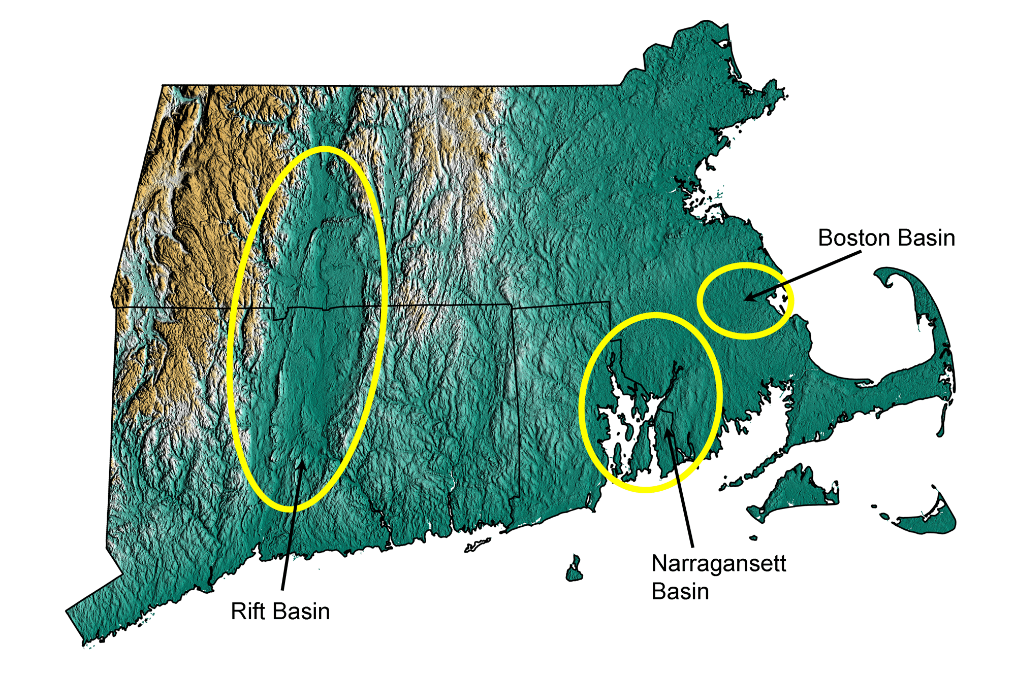
The New England Basins of the Exotic Terrane; greens indicate lower elevation, browns higher elevation. Topographic data derived from the Shuttle Radar Topography Mission (SRTM GL3) Global 90m (SRTM_GL3) (Farr, T. G., and M. Kobrick, 2000, Shuttle Radar Topography Mission produces a wealth of data. Eos Trans. AGU, 81:583-583.). Image created by Jonathan R. Hendricks for the Earth@Home project.