

Snapshot: Overview of the mineral resources of the Rocky Mountains region of the Northwest Central United States, including Montana, Wyoming, and Idaho.
Topics covered on this page: Overview; Northern Rocky Mountains; Middle Rocky Mountains; Southern Rocky Mountains; Wyoming Basin; Resources.
Credits: Most of the text of this page is derived from "Mineral resources of the Northwest Central US" by Thom R. Fisher and Robert M. Ross, chapter 5 in The Teacher-Friendly Guide to the Earth Science of the Northwest Central US, edited by Mark D. Lucas, Robert M. Ross, and Andrielle N. Swaby (published in 2015 by the Paleontological Research Institution). The book was adapted for the web by Elizabeth J. Hermsen and Jonathan R. Hendricks in 2021–2022. Changes include formatting and revisions to the text and images. Credits for individual images are given in figure captions.
Updates: Page last updated October 27, 2022.
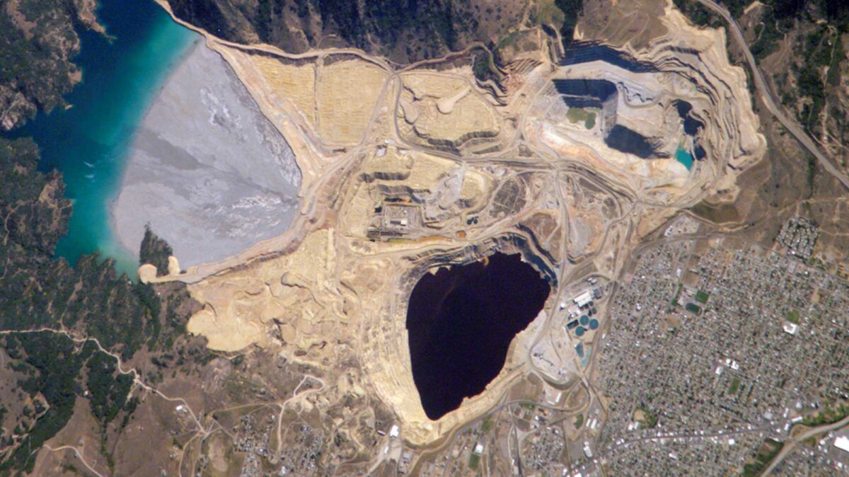
Image above: Satellite image of the Berkeley Pit and Yankee Doodle tailings pond near Butte, Montana. Image by NASA (Wikimedia Commons; public domain).
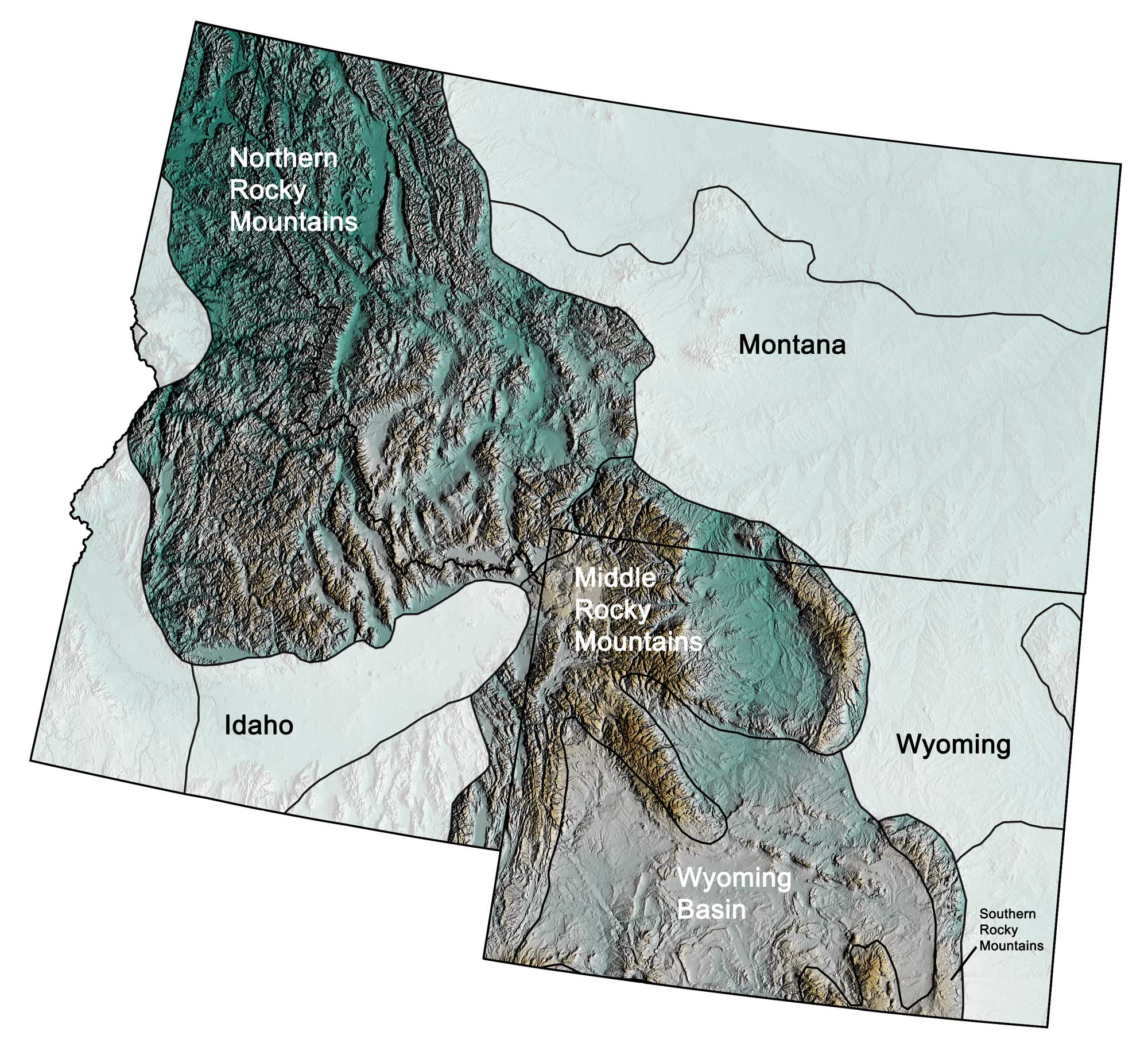
Physiographic subdivisions of the Rocky Mountains region of the northwest central United States; greens indicate lower elevation, browns higher elevation; black lines indicate physiographic boundaries of other provinces. Topographic data derived from the Shuttle Radar Topography Mission (SRTM GL3) Global 90m (SRTM_GL3) (Farr, T. G., and M. Kobrick, 2000, Shuttle Radar Topography Mission produces a wealth of data. Eos Trans. AGU, 81:583-583.). Image created by Jonathan R. Hendricks for the Earth@Home project.
Overview
The Rocky Mountain region is somewhat discontinuous, containing a scattered collection of mountain ranges and rocks of varying geologic origins and ages. The region’s mineral resources are found within its four physiographic subregions: the Northern, Middle, and Southern Rockies, as well as the Wyoming Basin.
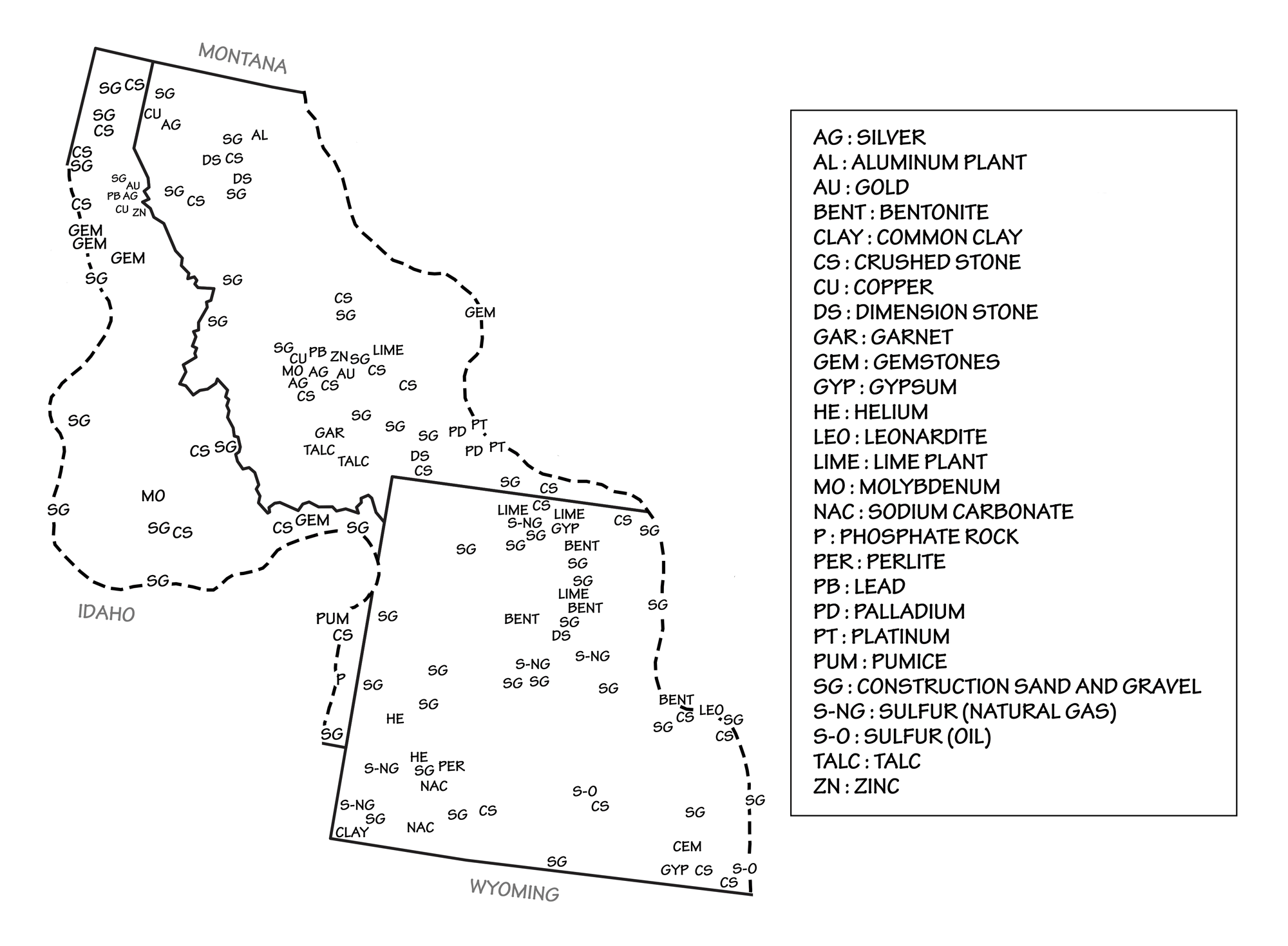
Principal mineral resources of the Rocky Mountains region. Map by Wade Greenberg-Brand, adapted from USGS 2009 State Minerals Yearbook.
Northern Rocky Mountains
The Northern Rockies subregion is located primarily in western Montana and eastern Idaho, and includes the massive Idaho Batholith, the Boulder Batholith, the Stillwater Igneous Complex at Nye, Montana, and the famous Coeur d’Alene mining district in the metamorphosed Precambrian sediments of northernmost Idaho. Many of the area’s mineral resources are concentrated within its batholiths, igneous complexes, and Precambrian sedimentary “Belt Series” rocks.
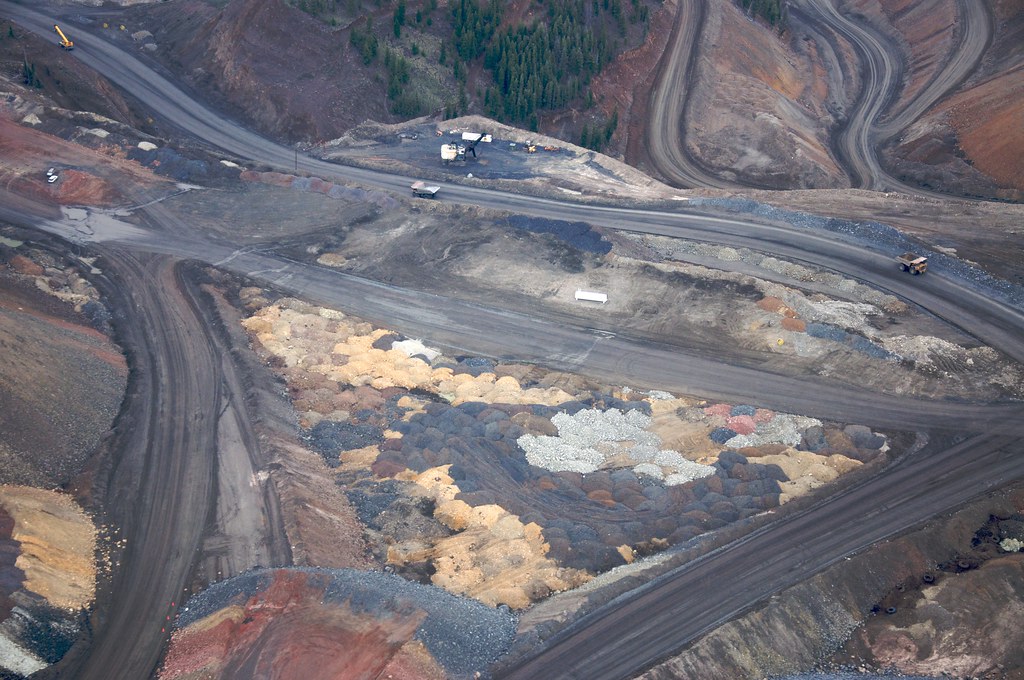
The Boulder Batholith, a pluton emplaced during the early Laramide Orogeny at Butte, Montana, has been called “the richest hill on Earth,” and it was a major producer of copper from about 1880 until 2004. The mines at Butte produced over 9.5 billion kilograms (21 billion pounds) of copper along with considerable quantities of zinc, lead, manganese, silver, gold, and molybdenum. The Berkeley Pit, one of Butte’s major open pit mines, produced about 450,000 kilograms (one billion pounds) of copper, silver, and gold during its operation from 1955 to 1982.
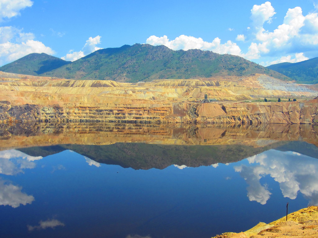
The Berkeley Pit in Montana and associated tailings pond. This open pit copper mine reaches a depth of about 540 meters (1780 feet), and is filled to a depth of about 270 meters (900 feet) with metal-laden acidic water. The mine is 1.6 kilometers (1 mile) long and 0.8 kilometers (0.5 miles) wide. Photograph by "ccarlstead" (Flickr; Creative Commons Attribution-NonCommercial-NoDerivs 2.0 Generic license). See satellite image of this mine at the top of this page.
Today, the pit is classified as a Superfund site due to the infiltration of groundwater that has become highly acidic and laden with heavy metals and dangerous chemicals leached from the surrounding rock.
The Stillwater Complex in the Beartooth Mountains northeast of Yellowstone is a 2.7-billion-year-old layered mafic intrusion, an inverted umbrella-shaped intrusive body that contains distinct layers. It is a major producer of chromium and the rare precious metals palladium, platinum, and other associated metal ores. Platinum group metals are used in many industrial applications, including the manufacture of catalytic converters for vehicles, data storage devices, anticancer drugs, fiber optic cables, gasoline additives, and fuel cells. Quantities of gold, silver, copper, and nickel are also recovered from this complex.
The Idaho Batholith, which was emplaced in multiple phases during the Sevier Orogeny, has three major lobes: the Atlanta lobe (100 to 75 million years ago), the Kiniksu Lobe (94 million years ago), and the Bitterroot Lobe (85 to 65 million years ago). Several million ounces of gold and silver, along with quantities of lead, zinc, and antimony in the form of the mineral stibnite (antimony sulfide, Sb₂S₃), have been mined from this batholith.
The Coeur d’Alene (Silver Valley) mining district of Idaho occurs within 1.4-billion-year-old metamorphosed sediments. These rocks are interpreted by some as having been deposited in a failed rift basin in the continental crust, probably similar to, but less developed than, the East African rift zone. Gold was discovered on the Coeur d’Alene River in 1874, which led to a short-lived gold rush. In 1884, the fi rst major discovery of lead-zinc-silver ores was made, and within a year several major mines were in operation. The district has produced over 51 billion grams (1.8 billion ounces) of silver, 2.7 million metric tons (3 million tons) of zinc, and 7.3 metric tons (8 million tons) of lead from 90 mines, some of which reach a depth of roughly 2400 meters (8000 feet). Two or three of these mines still produce today. The area is also famous for its many large specimens of pyromorphite, a crystalline lead phosphate mineral.
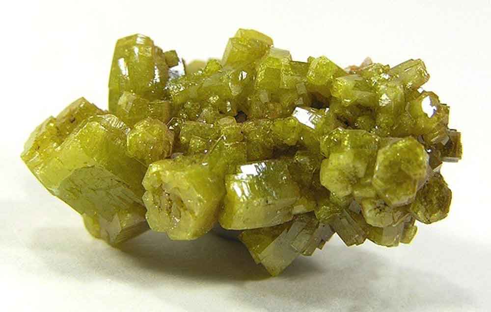
Pyromorphite from the Bunker Hill Mine, Coeur d’Alene mining district, Idaho. This mineral is found in association with lead-rich ores. Photograph by Robert M. Lavinsky (Wikimedia Commons; Creative Commons Attribution-Share Alike 3.0 Unported license; image resized).
In Lemhi County, Idaho, the most important mineral districts produce or have produced gold, silver, lead, copper, cobalt, nickel, tungsten, and molybdenum.
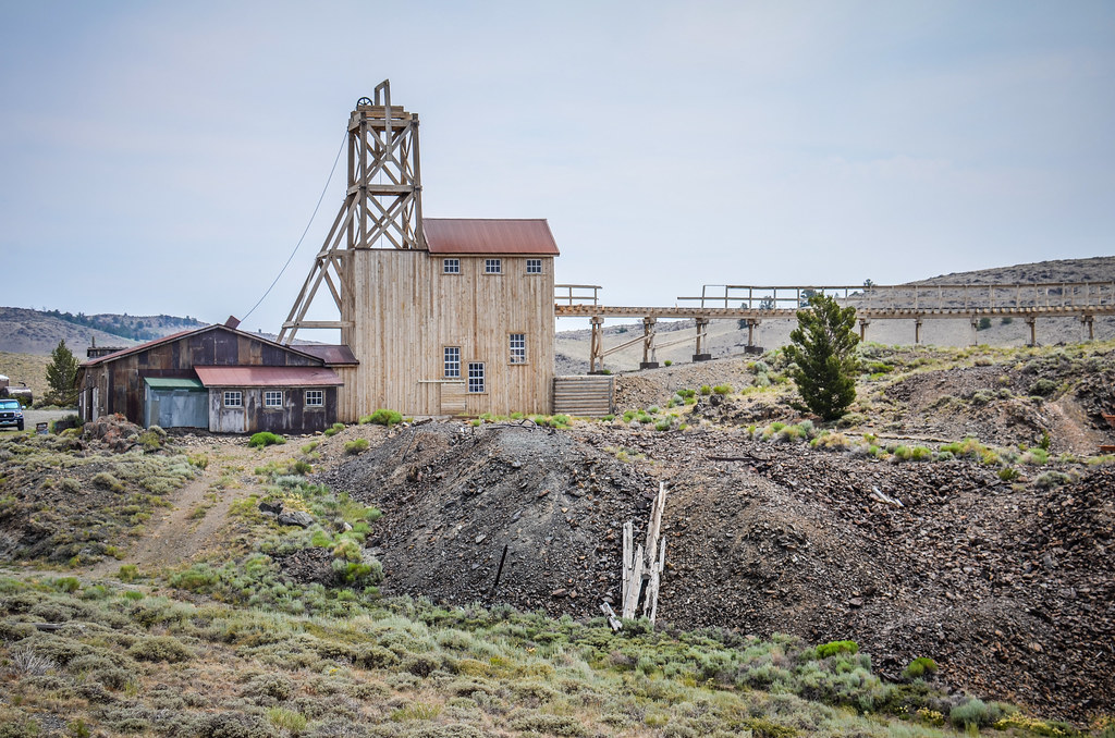
The Thompson Creek Molybdenum Pit Mine in Custer, Idaho. The mill here processes about 27,200 metric tons (30,000 tons) of ore per day, producing molybdenum sulfide concentrate that is later converted to specialty materials. Photograph by Sam Beebe (Flickr; Creative Commons Attribution 2.0 Generic license).
The Lemhi Pass area of Idaho and Montana is also one of the principal US sources of rare earth elements, including thorium. The area’s complex geology contains elements of crustal extension as well as thrust faulting associated with mountain building. The eastern portion of this area is dominated by “thin-skinned” thrusts (low-angle faults through surface sedimentary layers) that appear to contain controlled ore emplacement that occurred in two different phases. The first phase corresponds with the Sevier Orogeny (about 140 to 50 million years ago) and overlaps the Laramide Orogeny (about 70 to 40 million years ago). The second phase of emplacement began in the Miocene and Pliocene, corresponding to later phases of the formation of the Basin and Range (about 35 to 12 million years ago or later).
The Northern Rockies also produce high-quality gemstones. One of the area’s more famous gemstone localities is the Yogo Sapphire deposit in the Little Belt Mountains of Montana. Sapphire is otherwise known as the mineral corundum (Al₂O₃). Discovered in 1876, the Yogo mine was not recognized as a sapphire deposit until 1895, when Tiffany’s of New York pronounced Yogo sapphires to be “the finest precious gemstones” in the United States. Yogo sapphires, produced from greenish colored, igneous dikes called lamprophyres, range in color from cornflower blue to purple. Their coloring is due to traces of iron and titanium in the corundum’s crystal lattice. Montana also produces sapphires from three other major areas: the Missouri River area, which has yielded large blue-green sapphires of up to twenty carats in size, and the Rock Creek and Dry Cottonwood areas, which yield smaller, rounded gems that come in a variety of intense colors, from green and blue to pink and yellow.
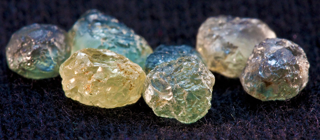
A variety of uncut sapphires from Montana. Photograph by "Orbital Joe" (Flickr; Creative Commons Attribution-NonCommercial-NoDerivs 2.0 Generic license).
The abundance of sapphires and other gem and mineral resources found in Montana has led to it being nicknamed the “Treasure State.”
The Rocky Mountains of Idaho are also renowned for their production of gemstones, including garnets, opal, topaz, jade, zircon, agate, and tourmaline. Idaho, as the “Gem State,” is especially famous for its gem-quality star garnets, an extremely rare form of garnet that is found in commercial quantity in only two places in the world, Idaho and India. Idaho’s garnets are found in pegmatites, schist, and other metamorphic rocks; although they can be removed from these rocks or the surrounding soil, they are most often collected from placer deposits in streams.
"Gem expert Eugene Stewart talks about the Idaho star garnet" by Idaho Statesman (YouTube).
Additionally, opals are produced in commercial quantities from mines near Spencer, Idaho.
Middle Rocky Mountains
Geologically, the Middle Rockies subregion represents a somewhat scattered and discontinuous collection of mountain ranges that vary in geologic origin and age. Many of these ranges formed during various intervals from the Cretaceous to the Miocene, and have Archean rocks at their core. They contain faults ranging from low-angle thrust faults to Basin and Range-type block faulting. At least one range owes its origin to volcanic and igneous activity rather than uplift.
The Teton Range near Jackson Hole, Wyoming is composed largely of Archean gneisses and has not yielded significant mineral deposits. The area, protected as part of Grand Teton National Park, formed around nine to six million years ago through Basin and Range-type extension. Southeast of Jackson Hole lie the Gros Ventre Range, the Wind River Range, and the Granite Mountains.
These mountains contain some of the oldest known rocks exposed on the North American continent. Archean granitic gneisses in these ranges have been dated at up to approximately 3.8 to 3.65 billion years old, along with metamorphosed sediments and volcanics (greenstone belts) at roughly 3.3 to 2.6 billion years old. Mining districts developed on these terranes yield gold, copper, and minor silver. To the north of the Wind River Range and east of Yellowstone National Park and the Tetons is the Absaroka Volcanic Plateau, which formed some 50 to 34 million years ago during the Eocene. The volcanics of this range are unrelated to those of the nearby and much younger Yellowstone Plateau (about 2 to 0.6 million years old) and are home to several mining districts that have yielded copper, molybdenum, lead, zinc, gold, and silver from what are known as copper-gold porphyry complexes. The Sunlight, New World, Kirwin, and Stinking Water districts in the Absaroka Mountains all contain placer gold deposits that can be recovered by panning, sluicing, and dredging.
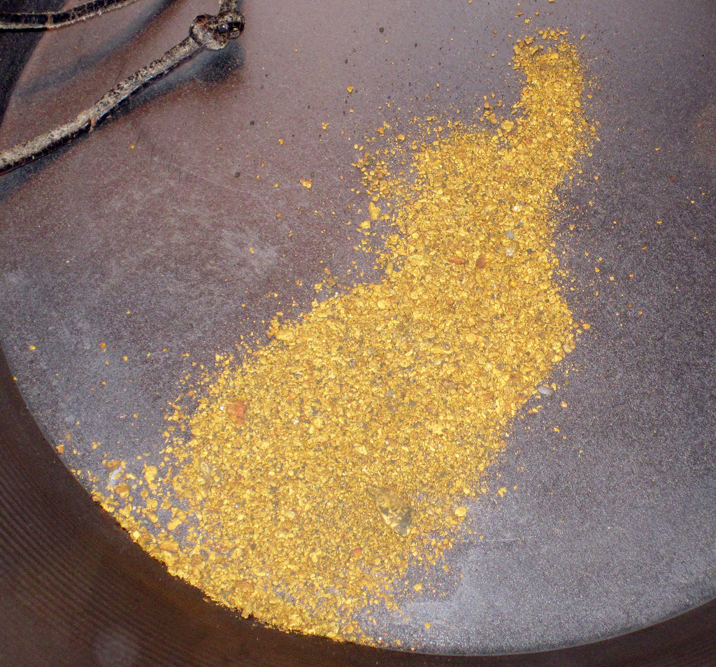
Gold dust (placer gold) found near Cody, Wyoming. Photograph by James St. John (Flickr; Creative Commons Attribution 2.0 Generic license).
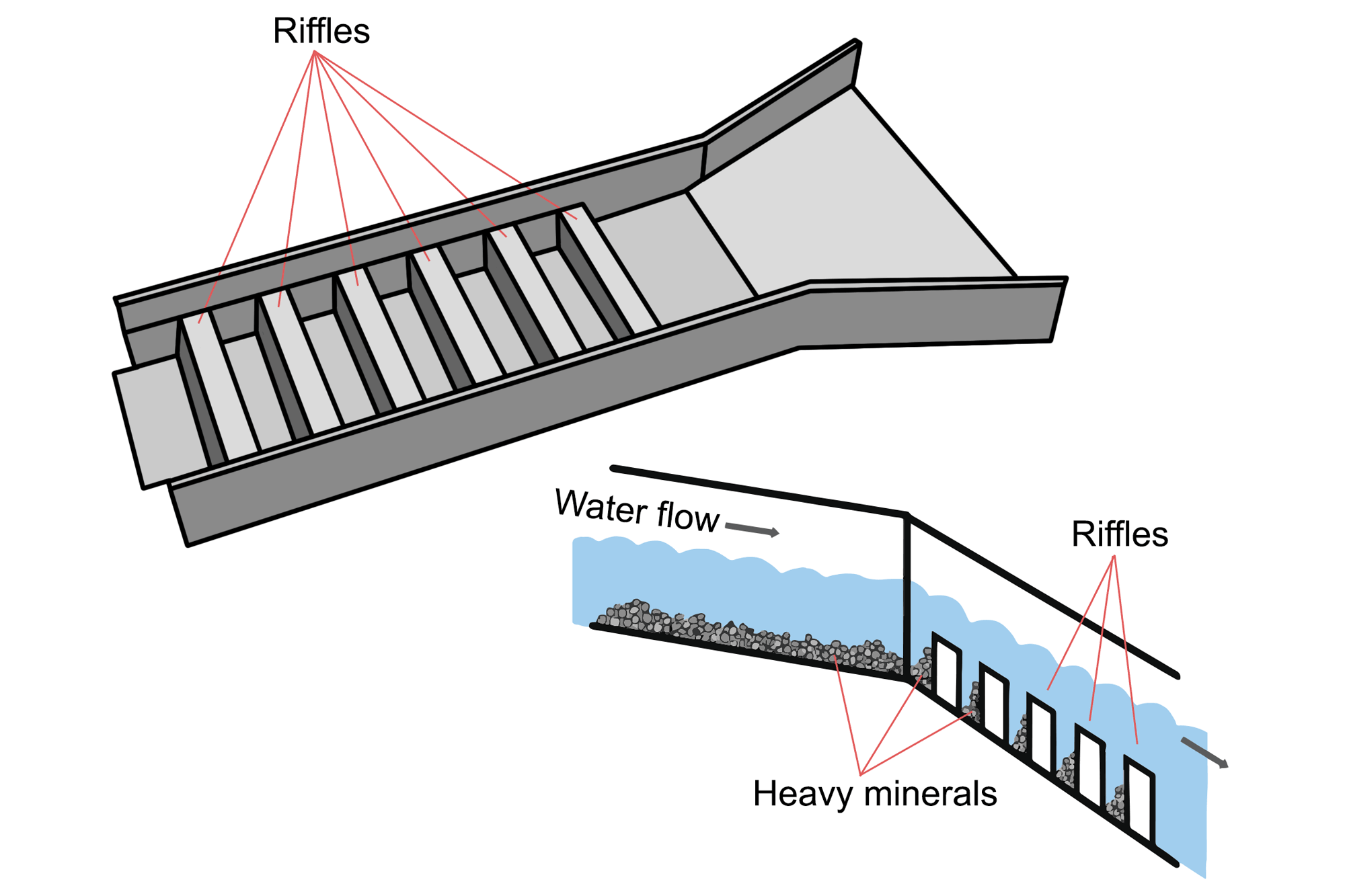
A sluice is a long tray through which water containing gold is directed. The sluice box contains riffles, or raised segments, which create eddies in the water flow. Larger and heavier particles, such as gold, are trapped by the eddies and sink behind the riffles where they can later be collected. Image by Wade Greenberg-Brand, modified for the Earth@Home project.
Although limited commercial efforts have been put into this area, gold prospecting is a popular recreational activity here.
The Bighorn Mountains, which lie east of the Absarokas and the Bighorn Basin, were uplifted during the Laramide Orogeny and contain Archean rocks at their core. The area has thus far proven somewhat uneconomically viable, although gold is known here, and placer deposits were likely mined by the Spanish in the 1700s and by Native Americans prior to the arrival of the Spaniards. The area also contains a relatively large deposit of rare earth elements—including dysprosium, used in high-performance magnets and compact fluorescent bulbs—and minor amounts of uranium have also been produced in the Bighorns.
The Middle Rockies of Wyoming, especially the Granite and Seminole Mountains, are famous for “Wyoming Jade,” otherwise known as nephrite jade (the mineral nephrite, an amphibole group mineral), which is highly prized for its deep apple-green color and transparency and is some of the finest nephrite in the world.
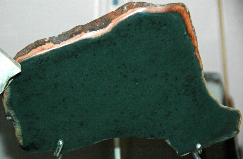
Nephrite jade from Wyoming. Photograph by James St. John (Flickr; Creative Commons Attribution 2.0 Generic license).
It ranges in color from deep green to a light yellowish variety known as “mutton fat.” Nephrite jade should not be confused with the pale green “true” jade (the mineral jadeite of the pyroxene mineral group). These two minerals are so similar that they were not distinguished from one another until 1863. Both minerals are formed during metamorphism, and Wyoming Jade is found within granites and gneisses where amphibole inclusions were altered by hydrothermal fluids.
Southern Rocky Mountains
In Wyoming, this subregion is defined by the Laramie and Medicine Bow mountains, and the Sierra Madre. Within this area lies the geologic boundary between early accreted terranes of the Proterozoic, at 1.9 to 1.8 billion years old, and very old (2.4- to 2.2-billion-year-old) early Proterozoic metamorphic rocks originally deposited as cratonic sediments. The Southern Rockies of Wyoming have produced gemstones as well as precious and base metals. Iron and diamond-bearing kimberlites are found in the Laramie Range and the State Line District, spanning the Wyoming-Colorado border. More than 130,000 diamonds have been recovered since they were first discovered here in 1975.
Gold and silver have been mined in the Gold Hill District and other parts of the Medicine Bow Mountains, and also in the Purgatory Gulch area of the Sierra Madre west of the Medicine Bows.
The Carissa Gold Mine, which operated from 1867 to 1954. In 2003, the state of Wyoming restored the mine and mill as a historic attraction. Photograph by "m01229" (Flickr; Creative Commons Attribution 2.0 Generic license).
These mountains were prospected extensively from the 1800s up through the Great Depression, when metal prices dropped to the point at which mining was no longer profitable. Rich copper deposits are found in the Ferris-Haggerty District of the Sierra Madre where massive chalcocite (copper sulfide, Cu₂S) and (minor) chalcopyrite (copper-iron sulfi de, CuFeS₂) ores are found in quartzite breccia. Uranium is produced from the Shirley Basin immediately west of the Laramie Range.
Wyoming Basin
The Wyoming Basin subregion covers most of southwestern Wyoming, and it effectively separates the Southern Rockies from the Middle Rockies. The Leucite Hills, at the northeast end of the Rock Springs Uplift, have yielded potassium- and magnesium-rich minerals as well as rare earth elements from young (about 1-million-year-old) lamproites. These rocks are rare and sometimes include diamond-bearing igneous rocks chemically similar to kimberlites; only 25 such occurrences are known worldwide. In the southwest part of the Wyoming Basin, indicator minerals associated with diamond-bearing kimberlites have been found in surface sediments. The presence of indicator minerals suggests the presence of diamond pipes beneath the sedimentary cover in this area. A number of uranium deposits are found in the northeastern part (Great Divide Basin) of the Wyoming Basin, where several new mines are in the process of receiving permits.
The Green River Basin in Wyoming is home to the world’s largest deposit of trona, a non-marine evaporite mineral that is mined as a primary source of sodium carbonate. The layered deposits in Wyoming, which lie 240 to 490 meters (800 to 1600 feet) below ground, were deposited in a lake during the Paleogene. Trona is a common food additive and water softener, and it also has applications in the manufacturing of paper, textiles, glass, and detergents.
Resources
Resources from the Paleontological Research Institution
Digital Atlas of Ancient Life: Minerals (collection of 3D models on Sketchfab): https://skfb.ly/6WxTo
Digital Encyclopedia of Earth Science: Minerals: https://earthathome.org/de/minerals/