

Page snapshot: Introduction to the geologic history of the south-central U.S. from the Precambrian to the Quaternary Period.
Topics covered on this page: Precambrian; Paleozoic; Cambrian; Ordovician; Silurian to Devonian; Carboniferous to Permian; Triassic to Jurassic; Cretaceous to Neogene; The Farallon Plate; Western Interior Seaway; Laramide Orogeny; Volcanic activity and Basin and Range; Formation of the Coastal Plain; Origin of the Mississippi Embayment; Origin of Coastal Plain sediments; Quaternary; Resources.
Credits: Most of the text of this page comes from "Geologic history of the South Central US" by Richard A. Kissel and Alex F. Wall, chapter 1 in The Teacher-Friendly Guide to the Geology of the South Central US, edited by Mark D. Lucas, Robert M. Ross, and Andrielle N. Swaby (published in 2015 by the Paleontological Research Institution; currently out of print). The book was adapted for the web by Elizabeth J. Hermsen and Jonathan R. Hendricks in 2022. Changes include formatting and revisions to the text and images. Credits for individual images are given in figure captions.
Updates: Page last updated June 22, 2022.
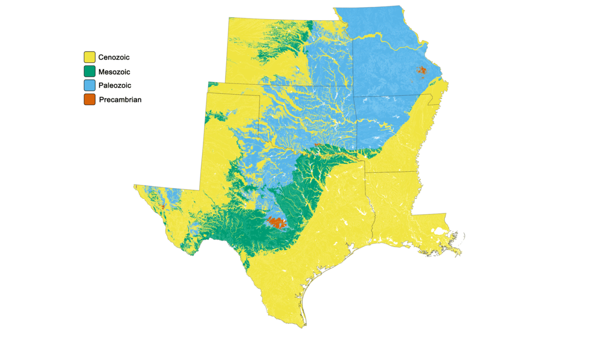
Image above: Simple geologic map of the South-Central United States. Image by Jonathan R. Hendricks for the Earth@Home project developed using QGIS and USGS data from Horton et al. (2017).
Precambrian (4.6 billion to 541 million years ago)
The Earth is estimated to be approximately 4.6 billion years old. Rocks dating to 4 billion years old are found on almost every continent, but the oldest rocks known are 4.3-billion-year-old greenstone beds found along the eastern shore of Hudson Bay in northern Quebec, Canada. These are part of the Canadian shield, the ancient core of the North American continental landmass.
More than a billion years ago, narrow strips of land collided with and compressed one another to form the Precambrian beginnings of the North American continent, also called Laurentia. From this proto-North America, sediment was eroded and transported by rivers and streams across the ancient continental margins and then into the adjacent oceans.
The south-central states are divided up into five different geologic provinces or regions: 1) the Central Lowland 2) the Interior Highlands, 3) the Coastal Plain, 4) the Great Plains, and 5) the Basin and Range. Among these regions, Precambrian-aged rock is exposed in only a few discrete places in Texas, Oklahoma, and Missouri, although it underlies larger swaths of the area. Much of the basement rock in the south-central U.S. is a remnant of volcanic islands and a submarine mountain range that formed about 1.4 billion years ago as magma welled up from the mantle and cooled into granite or erupted, forming rhyolite. These islands later collided with other microcontinents to form the bedrock of the proto-North American continent.
The oldest exposed rocks (in other words, rocks that can be seen at the surface) in the south-central U.S. are found within the Saint Francois Mountains. The Saint Francois Mountains are in southeastern Missouri and form the core of the Ozark Mountains in the Interior Highlands region. The Saint Francois Mountains are the exposed portion of a Precambrian igneous mountain chain and include granitic and rhyolitic igneous rocks dating to nearly 1.5 billion years ago.
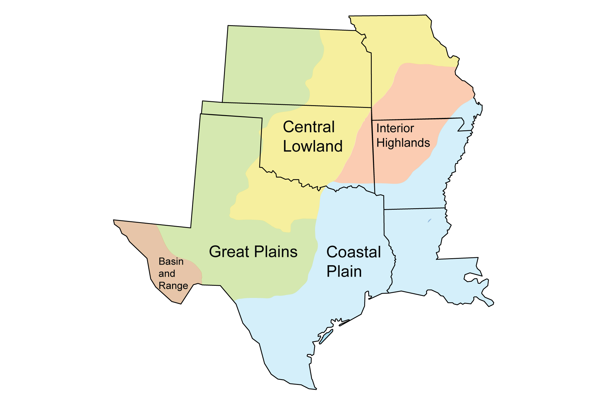
Physiographic regions of the south-central U.S.
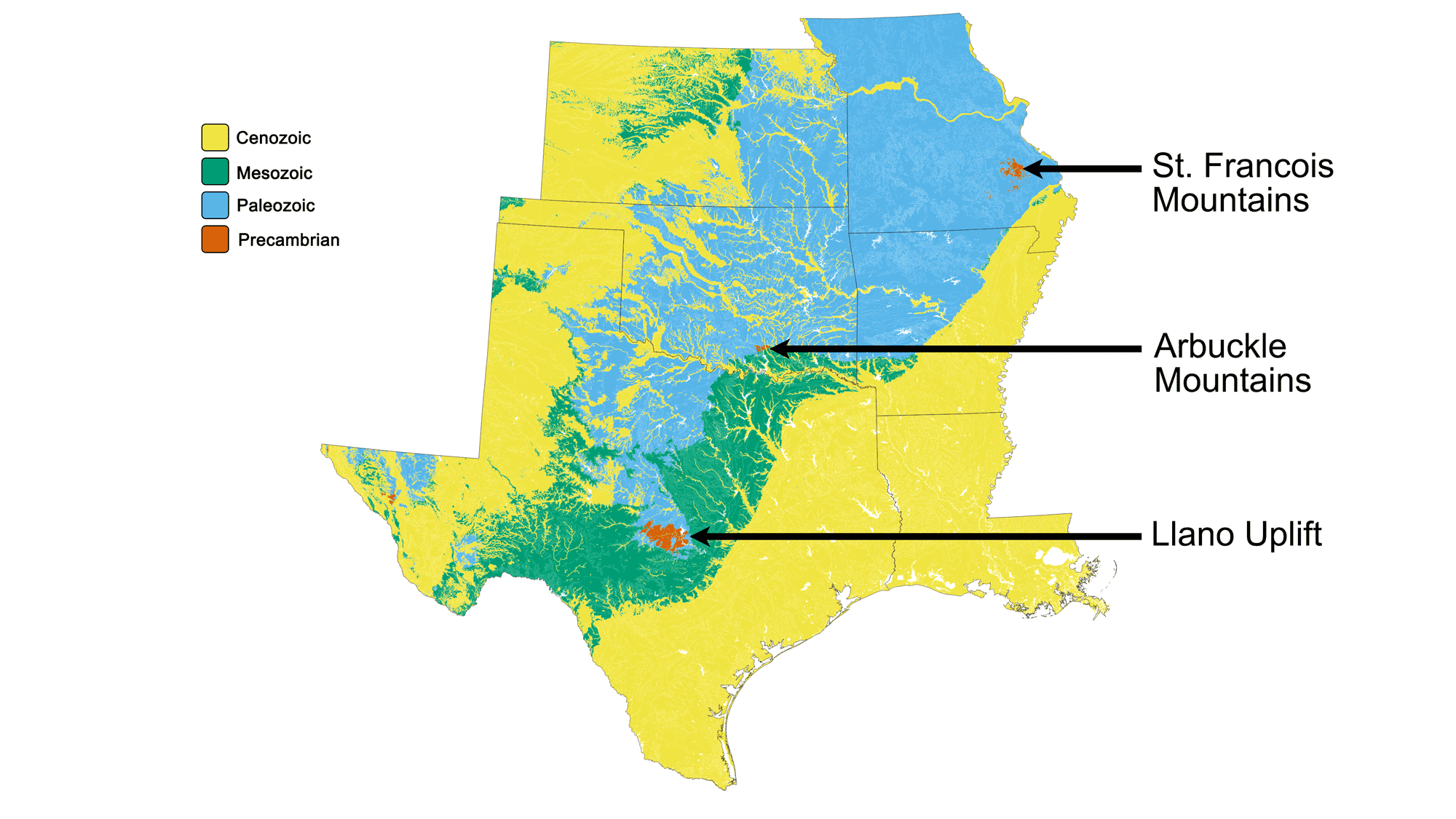
Locations of some of the Precambrian rocks in the south-central U.S.
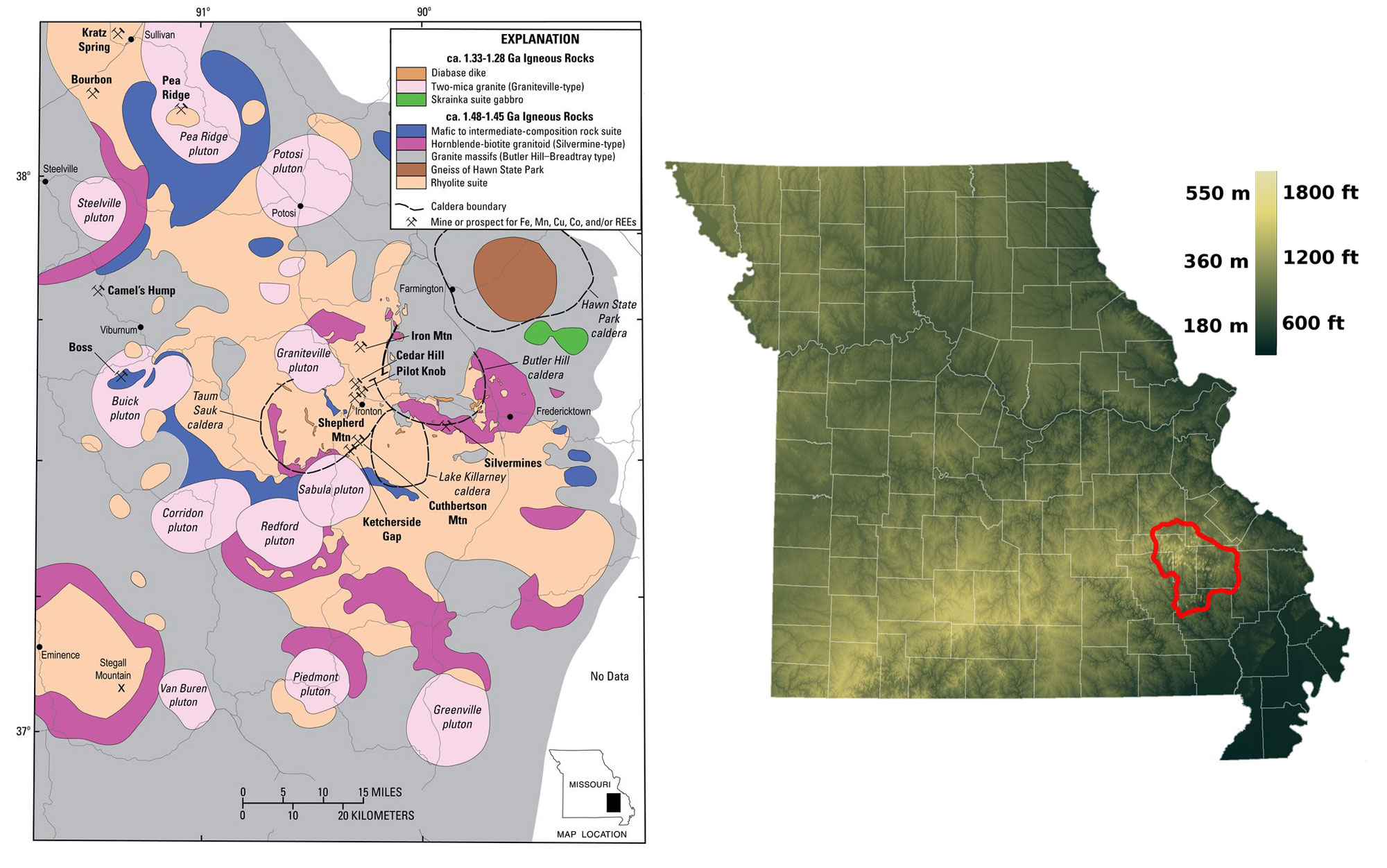
St. Francois Mountains, Missouri. Left: Simplified geologic map of the Precambrian rocks of the St. Francois Mountains. Source: USGS, from Day et al. (2016), public domain. Right: Location of St. Francois mountains in the state of Missouri (red line marks approximate boundary). Map by Kbh3rd (Wikimedia Commons, Creative Commons Attribution-Share Alike 3.0 Unported license, image cropped and resized).
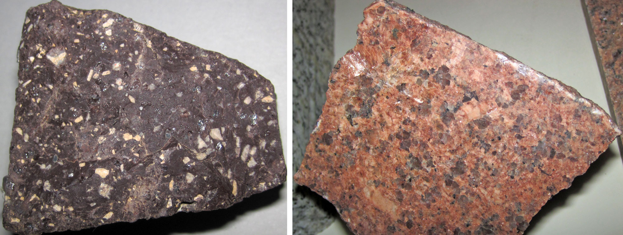
Precambrian igneous rocks from the St. Francois Mountains in Missouri. Left: Shut-in Mountain Rhyolite, 1.3-1.5 billion years old. Right: Sample of polished Missouri red granite, about 1.3 billion years old. Photo of rhyolite and photo of granite by James St. John (flickr, Creative Commons Attribution 2.0 Generic license, images cropped and resized).
In central Texas, the Llano Uplift of the Great Plains province contains gneiss and granite that formed between 1.4 and 1.1 billion years ago. The Franklin Mountains near El Paso, Texas (far western Texas), in the Basin and Range province, also contain Precambrian-aged rock.
During the next several tens of millions of years, parts of these mountains were buried in sediment that originated in Laurentia’s (proto-North America's) northeastern region. The sedimentary rock that formed was later metamorphosed. It is now exposed at the Llano Uplift in a ring surrounding the older Precambrian rocks.
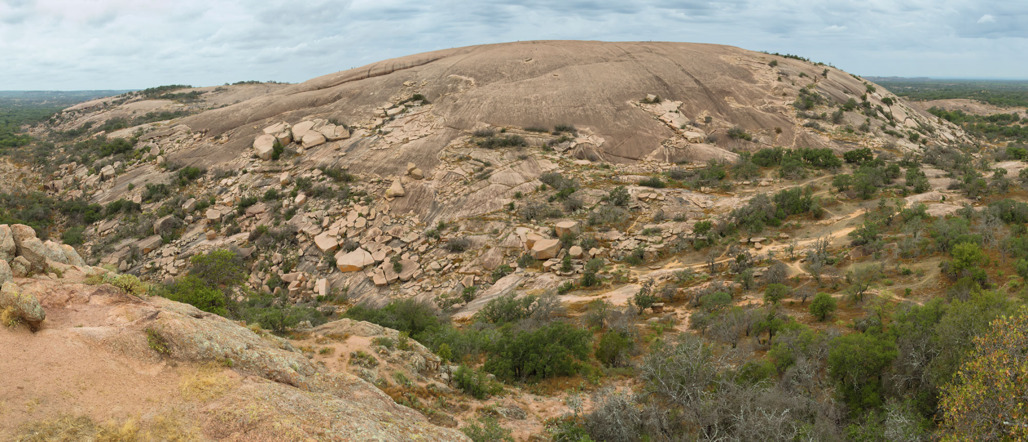
Enchanted Rock, a Precambrian granitic dome in Enchanted Rock State Park, Llano Uplift, Texas. Photo by Jujutacular (Wikimedia Commons, Creative Commons Attribution 3.0 Unported, image cropped and resized).
The remainder of the Precambrian period saw the formation of the supercontinent Rodinia about 1.1 billion years ago, followed by its eventual breakup about 750 million years ago. The tectonic activity that generated the formation and breakup of Rodinia may have contributed to the metamorphism of some of the Precambrian rocks in the south-central region.
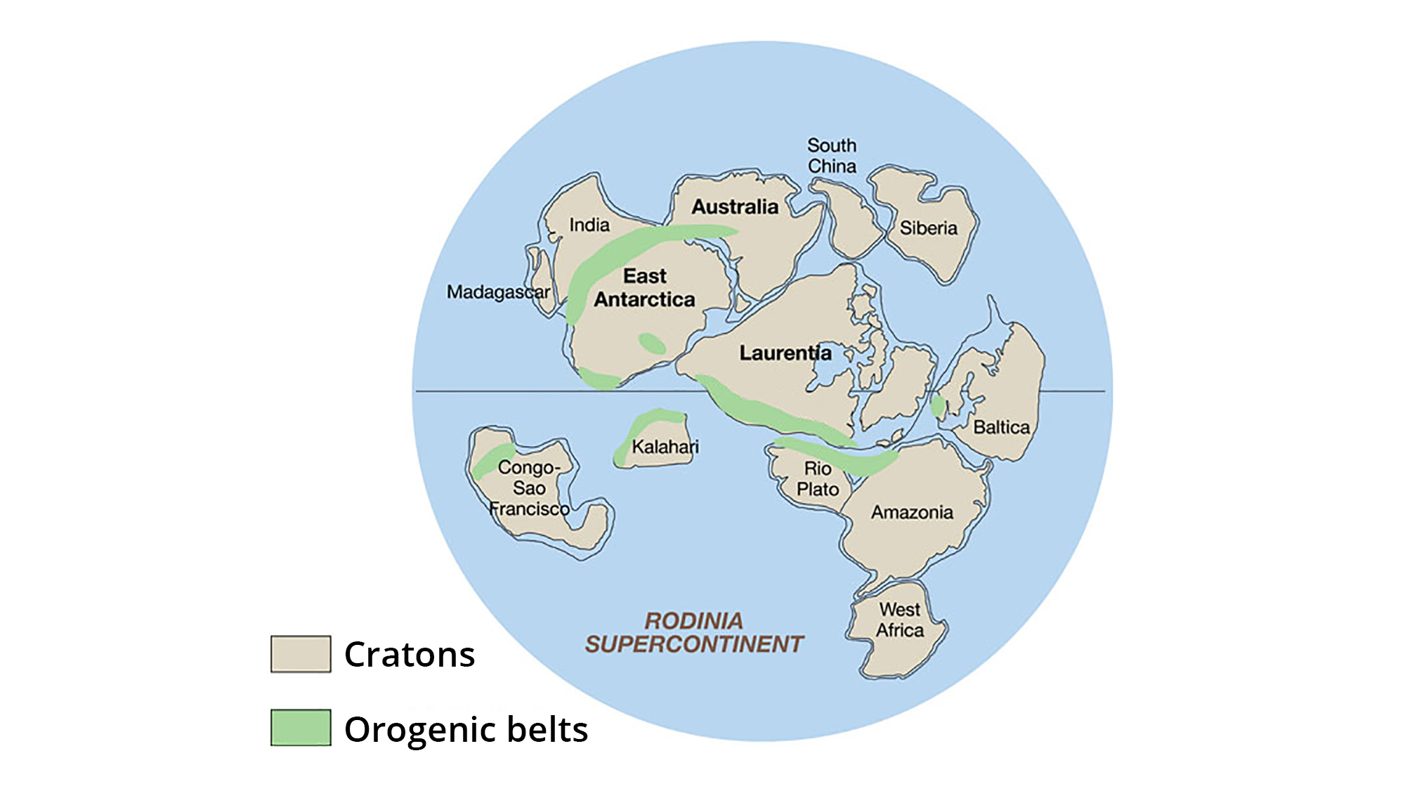
The supercontinent Rodinia, around 1.1 billion years ago. Laurentia represents proto-North America. Image adapted from original created by John Goodge for the United States Geological Survey (public domain).
As Rodinia broke up, a rift began to form in what is now southwest Oklahoma. Magma rising near the surface cooled to form parts of the Wichita Mountains. The rifting eventually failed, but not before the crust had thinned sufficiently to create a series of inland basins in southwestern Oklahoma and western Texas.
By the close of the Precambrian, very little existed of the south-central U.S. as we know it now. Deposition of sediments within shallow seas during the Paleozoic and Mesozoic eras, followed by deposition from the eroding Rocky Mountains and Interior Highlands during the Cenozoic era, would shape the south-central U.S. into the region familiar to geologists today.
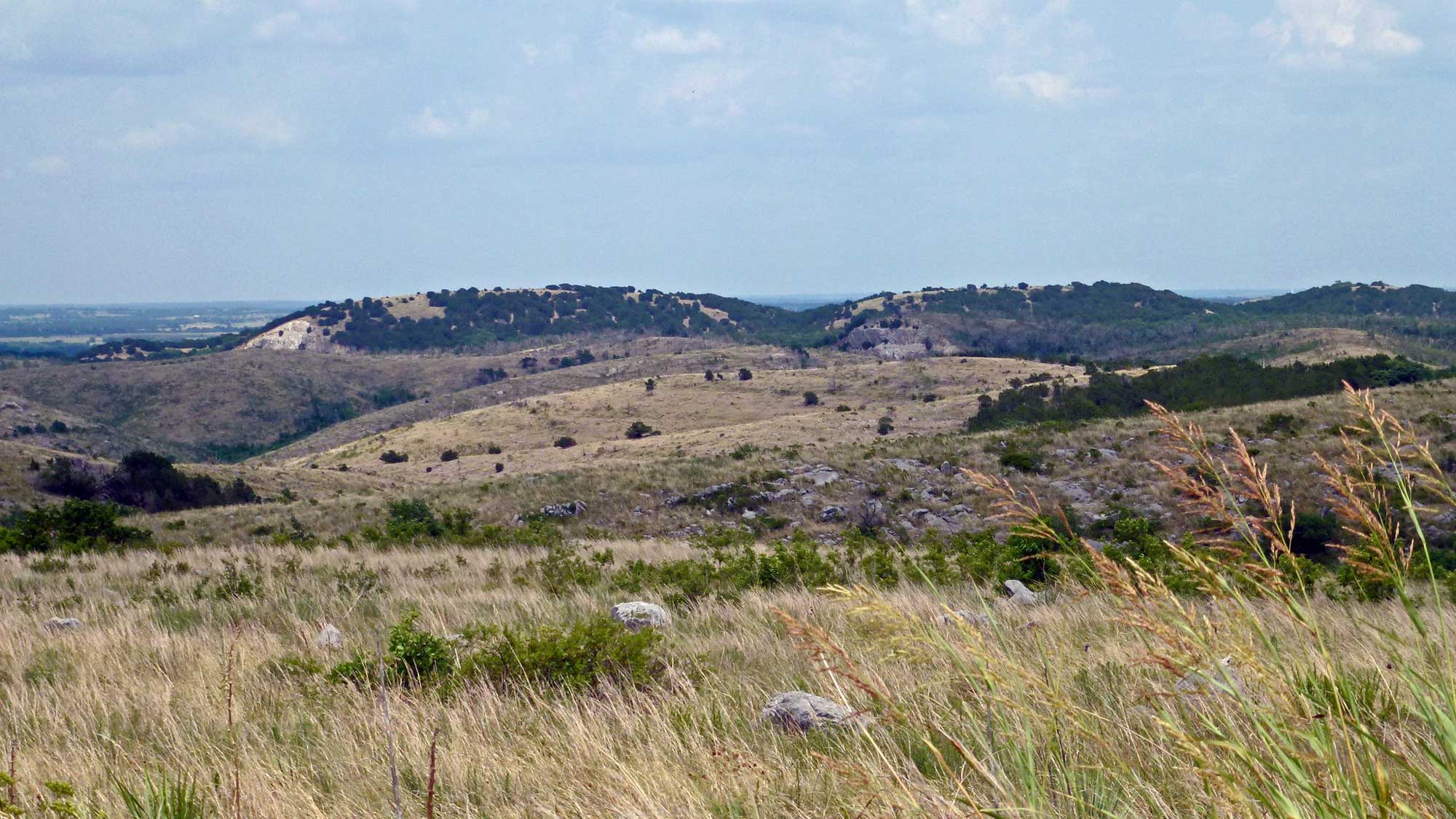
The Arbuckle Mountains, Oklahoma. Photograph by Granger Meador (Flickr; Creative Commons Attribution-NonCommercial 2.0 Generic license; image cropped and resized).
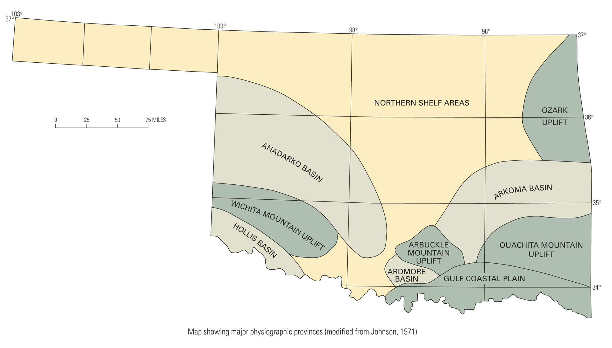
Map of physiographic provinces in the state of Oklahoma, showing basins and uplifts. Source: Digital geologic map database for the state of Oklahoma, compiled by W. D. Heran, G. N. Green, and D. B. Stoeser (2003), USGS.
Paleozoic (541 to 252 million years ago)
During the Paleozoic, shallow inland seas spread across the interior of Laurentia (ancient North America), covering North America’s Precambrian shield. Even the high areas of northwestern Texas and the Ozark Mountains of Missouri were occasionally underwater.
Extensive deposition of sediment occurred in the submerged areas of the south-central U.S. Across significant sections of Kansas, Missouri, Oklahoma, and Texas, a sequence of sediments 1500 to 3000 meters (5000 to 10,000 feet) thick was deposited during the Paleozoic and much of the Mesozoic. In many areas, these sediments are found only at depth (meaning, they are buried and not exposed at the surface), with younger sediments from streams and other sources overlaying them at the surface. However, rocks of Paleozoic age are found at the surface in much of the Central Lowland and Interior Highlands regions.
Cambrian (541 to 485 million years ago)
Beginning in the Cambrian period, about 545 million years ago, the southern portion of the south-central U.S. was persistently submerged. A further rise in sea level inundated the entire region during the late Cambrian. Cambrian fossils are preserved in rocks that are now near Oklahoma’s Wichita Mountains, Oklahoma's Arbuckle Mountains (south-central Oklahoma), and Missouri’s Saint Francois Mountains.
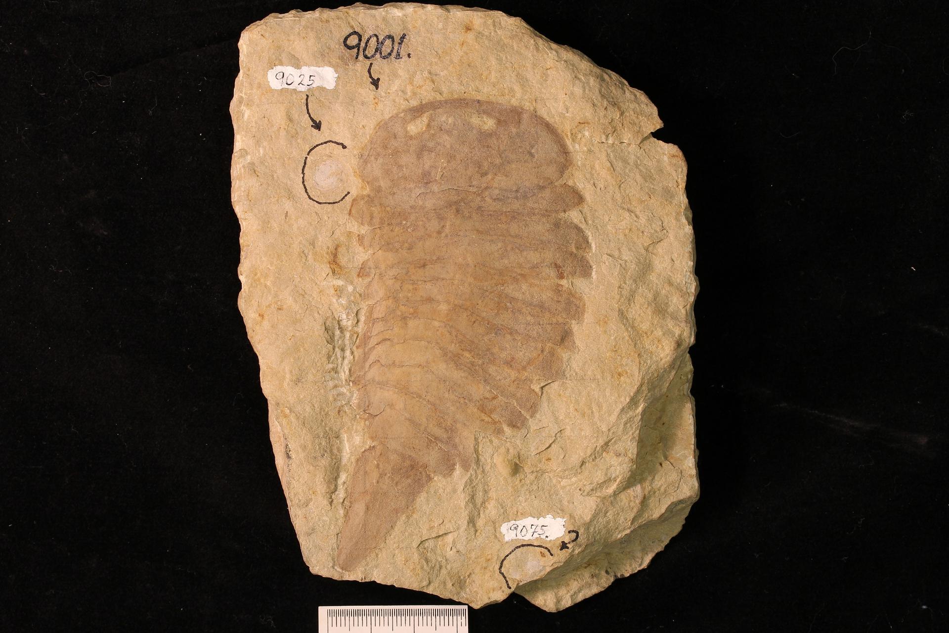
Strabops thacheri, a strabopid (a type of extinct marine arthropod) from the Cambrian of St. Francois County, Missouri. Photo of YPM IP 009001 by Susan H. Butts, 2016 (Yale Peabody Museum of Natural History/YPM, via GBIF.org, CC0 1.0 Universal/Public Domain Dedication).
Ordovician (485 to 444 million years ago)
During the Ordovician, the south-central U.S. was rotated roughly 90º clockwise relative to its current position. New England, now located northeast of the south-central U.S., was actually oriented toward the southeast at that time.
Ordovician-aged rocks in southern Missouri and northern Arkansas show sequences of sandstones, carbonates, and shales that are indicative of fluctuating sea levels and shifting shorelines. Invertebrate fossils are somewhat common in these rocks. In Missouri, a layer of clay formed of volcanic ash hints at tectonic activity far off to the east. In Oklahoma, limited exposures of Ordovician rock occur in the regions of the Wichita Mountains and Arbuckle Mountains.
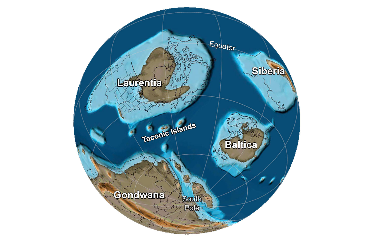
The globe about 485 million years ago, near the Cambrian-Ordovician boundary. Note that the south-central region of the U.S. is covered by a shallow sea. Reconstruction created using basemap from the PALEOMAP PaleoAtlas for GPlates and the PaleoData Plotter Program, PALEOMAP Project by C. R. Scotese (2016); map annotations by Jonathan R. Hendricks for PRI's Earth@Home project (CC BY-NC-SA 4.0 license).
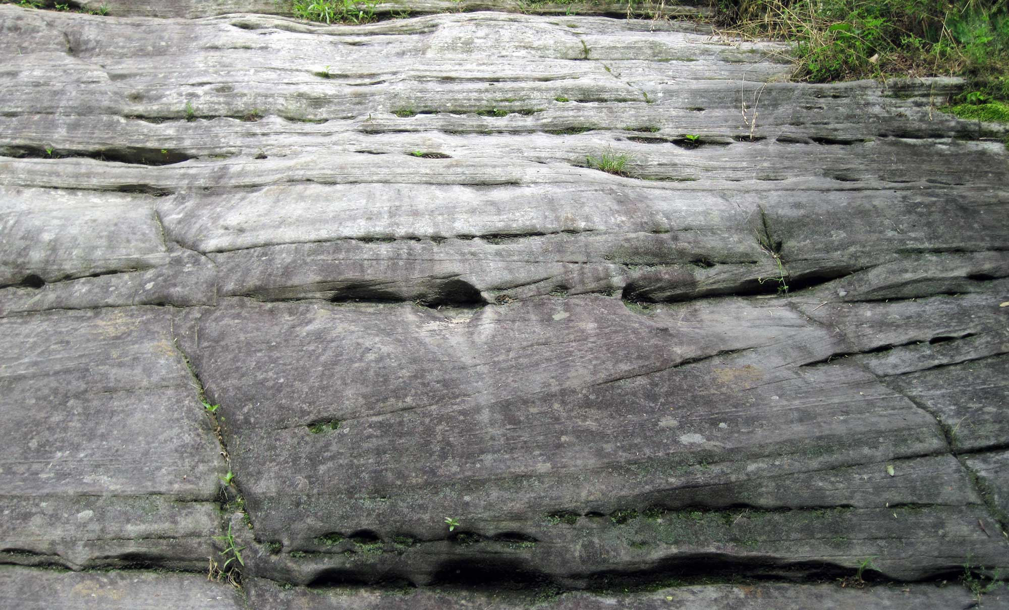
Middle Ordovician St. Peter Sandstone, Montgomery County, Missouri. Photo by James St. John (flickr, Creative Commons Attribution 2.0 Generic license, images cropped and resized).
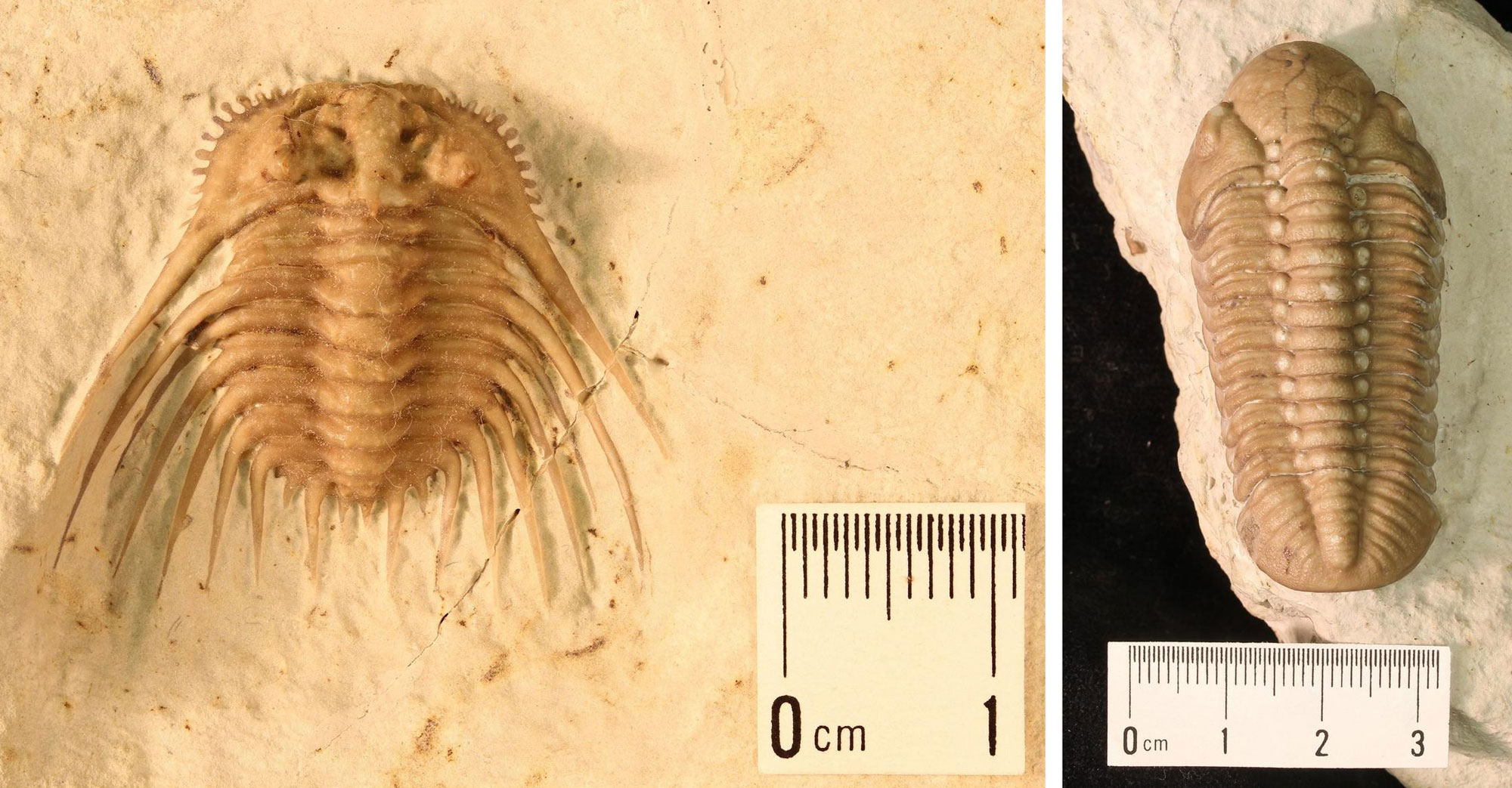
Trilobites (Homotelus bromidensis), Ordovician Bromide Formation, Carter County (Arbuckle Mountains), Oklahoma. Model of PRI 45505 by Emily Hauf, specimen from the collections fo the Paleontological Research Institution, Ithaca, New York. Longest dimension about 14 centimeters (5.5 inches). CC0 1.0 Universal/Public Domain Dedication.
Silurian to Devonian (444 to 359 million years ago)
During the Silurian and Devonian periods, the sea again advanced over the entire south-central U.S. region and then retreated to what is now its southeastern third. Very little bedrock is preserved from this time, although some fossil-bearing Devonian rocks are known from, for example, southeastern Oklahoma.
Trilobites from the lower Devonian Haragan Limestone, Coal County, Oklahoma. Left: Kettneraspis williamsi (YPM IP 428842). Right: Reedops deckeri (YPM IP 531078). Photos by Jessica Utrup (YPM/Yale Peabody Museum of Natural History, CC0 1.0 Universal/Public Domain Dedication, accessed via Global Biodiversity Information Facility/GBIF.org).
Carboniferous to Permian (359 to 252 million years ago)
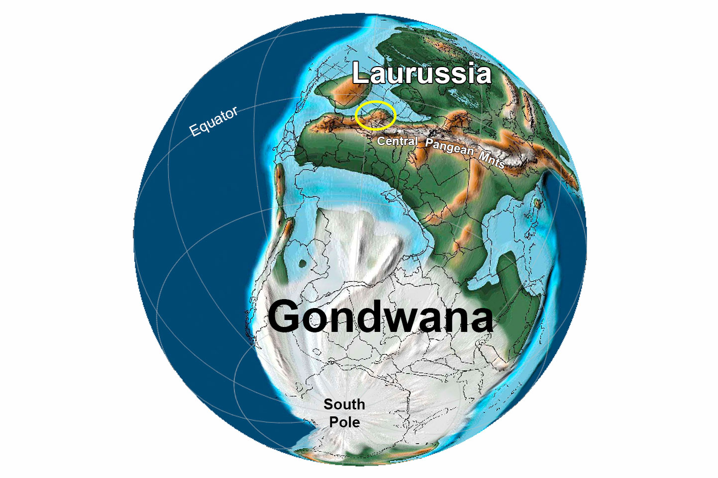
During the Carboniferous, the supercontinent of Pangaea began to assemble. Laurussia, a continent formed by the collision of Laurasia (proto-North America) and Baltica (proto-Europe), collided with Gondwana (the southern supercontinent consisting of Africa, Antarctica, Australia, India, and South America). This collision formed the central and southern Appalachian Mountains—at that time, part of a long chain of mountains called the Central Pangean Mountains—and the south-central U.S. Interior Highlands.
The Interior Highlands can be divided into two distinct sections. The first is the Ozark Uplift. The Ozark Uplift is found in southern Missouri, northern Arkansas, and northeastern Oklahoma. After the Ozarks were uplifted, erosion shaped the mountains into a series of plateaus capped by more resistant layers that are cut extensively by stream and river valleys.
Earth 300 million years ago, during the end of the Carboniferous Period (Pennsylvanian). The approximate location of the Interior Highlands region is circled in yellow. Reconstruction created using basemap from the PALEOMAP PaleoAtlas for GPlates and the PaleoData Plotter Program, PALEOMAP Project by C. R. Scotese (2016); map annotations by Jonathan R. Hendricks & Elizabeth J. Hermsen for PRI's Earth@Home project (CC BY-NC-SA 4.0 license).
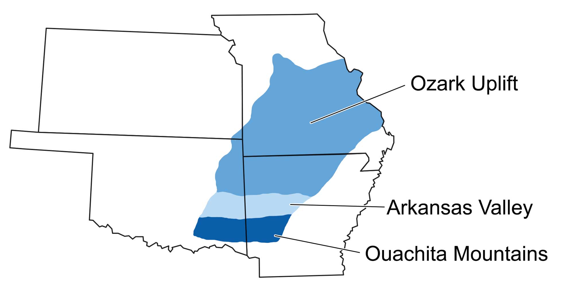
The three major topographic divisions of the Interior Highlands: the Ouachita Mountains, Arkansas Valley, and Ozark Uplift. Image modified by original by Wade Greenberg-Brand, in turn adapted from image by G. G. Huffman, Oklahoma Geological Survey.
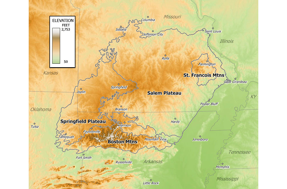
Elevation map of the Ozark Mountains. The Ozark Mountains are made up of four regions: the Saint Francois Mountains, the Salem Plateau, the Boston Mountains, and the Springfield Plateau. Map by Tosborn (Wikimedia Commons, public domain).
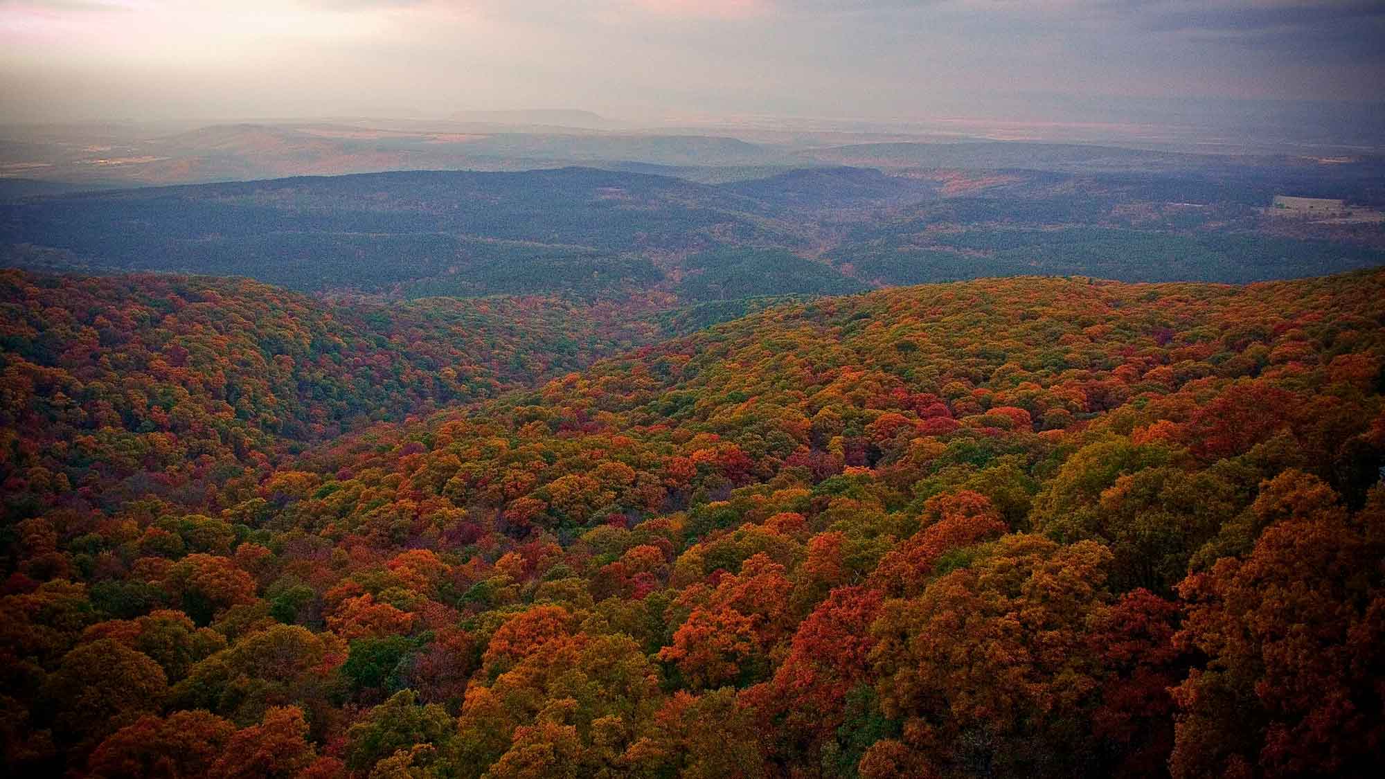
View of the Ozarks from the top of Mount Magazine, Arkansas. Photograph by "Anna" (Flickr; Creative Commons Attribution-NonCommercial 2.0 Generic license).
The second section of the Interior Highlands is the Ouachita Mountains. The Ouachita Mountains are found in west central Arkansas, southeastern Oklahoma, and, beneath the surface, significant parts of central Texas. These mountains also originally extended into Mississippi, but are now buried beneath younger sediments in that region.
The Ouachitas formed when the South American portion of Gondwana collided with the North America portion of Laurussia during the early Pennsylvanian. As the continents collided, ancient seafloor was compressed into a series of folds and faults, uplifing the mountains. Since the collision occurred in a north-south direction, the folds extend mostly in an east-west direction.
Once established, the Ouachita Mountains began to erode, filling the submarine basins that had formed in western Texas as Rodinia broke up. By the Permian, these basins were full of rich organic material. Today, they are collectively called the Permian Basin, an area famous for its petroleum production.
By the Permian, the assembly of Pangaea was essentially complete. As the Permian came to an end, the south-central U.S. transitioned to a terrestrial environment. In Texas, rocks from this time include salt and gypsum that were deposited as the sea retreated.

Satellite image of the Ouachita Mountains, Oklahoma. In this image, the major roads are running approximately north-south. This view is form the western edge of the Ouachita Mountains, where they turn away from a strictly east-west orientation toward the southwest. Image by Jesse Allen and Robert Simmon, NASA Earth Observatory, taken November 2002 (image resized, used following NASA image use policy).
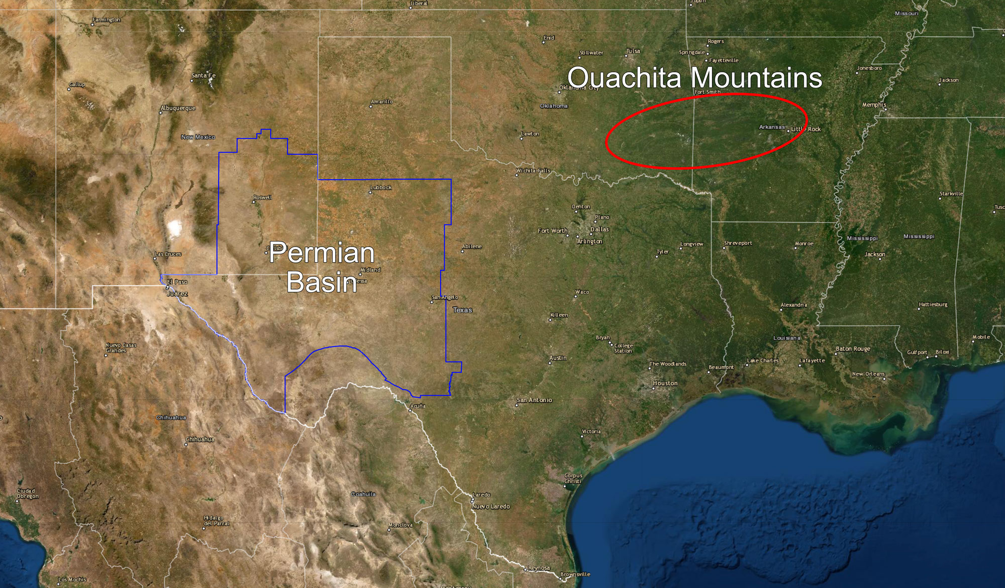
Map showing the location of the Permian Basin in western Texas and eastern New Mexico and the Ouachita Mountains in Oklahoma and Arkansas. Map made using USGS map viewer, modified for Earth@Home.
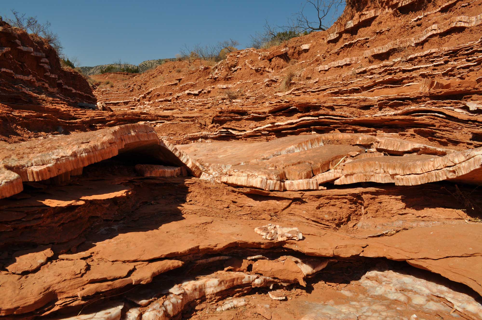
Permian red beds with layers of gypsum (lighter-colored layers), Caprock Canyons State Park, Texas. Photo by Fredlyfish4 (Wikimedia Commons, Creative Commons Attribution-ShareAlike 3.0 Unported license, image resized).
Triassic to Jurassic (252 to 145 million years ago)
At the beginning of the Mesozoic, the south-central U.S. was a part of Pangaea. Most of the south-central U.S. was above sea level at this time, partly due to regional uplift and partly due to the arrangement of most of Earth's land into a supercontinent. Fossil-bearing Triassic red bed exposures occur in Texas on the border of the Great Plains and Central lowlands regions, reflecting the largely terrestrial environment of the Triassic.
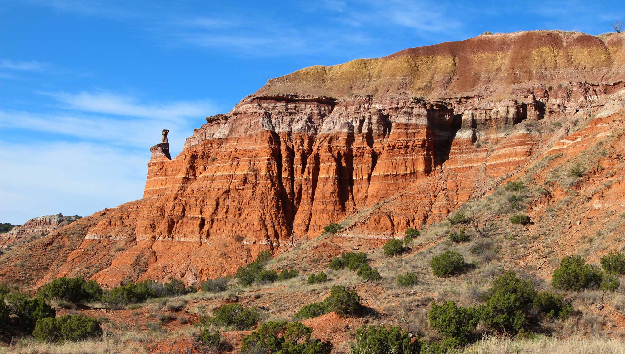
Palo Duro Canyon in the Texas Panhandle region (northern Texas) is made up primarily of Triassic rocks of the Tecovas and Trujillo formations (Dockum Group), which are overlain by late Cenozoic Ogallala Formation rocks. Photo by Roy Luck (flickr, Creative Commons Attribution 2.0 Generic license, image cropped and resized).
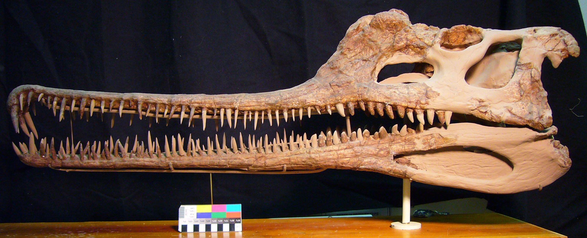
A phytosaur skull (Rutiodon), Triassic, Dockum Formation, Howard County, Texas. Phytosaurs looked similar to crocodiles. Photo of USNM V 21376 by Michael Brett-Surman (Department of Paleobiology, NMNH, Smithsonian Institution, Creative Commons CC0 1.0 Universal/Public Domain Dedication).
At the beginning of the Triassic, the Ouachita Mountains ran from the southwest to the northeast, where they were contiguous with the Appalachian Mountains, forming a huge range that extended from Mexico to Maine. By the end of the Triassic, the continental plates began to move apart once again, thinning the crust and causing it to subside. As the continents drifted apart, the Interior Highlands and the Appalachian Mountains pulled away from each other. Today, the Mississippi Embayment of the Coastal Plain region and the Inland Basin stand between the Interior Highlands and the Appalachians.
During the Jurassic, North and South America began to separate. Rifting in the Ouachitas opened up a growing basin between the Yucatan and south-central U.S. that was eventually flooded by water from the Pacific Ocean, creating the Gulf of Mexico. The Louann Salt formation, famous for its impermeable salt domes, was deposited in this basin over many millions of years.
By the late Jurassic, the spreading rift had produced a substantial amount of oceanic crust, forming a deep and expanding floor to the Gulf and creating a connection with the newly developing Atlantic Ocean. The Gulf then began to function as a seaway, and the resulting circulation caused the deposition of salt to cease.
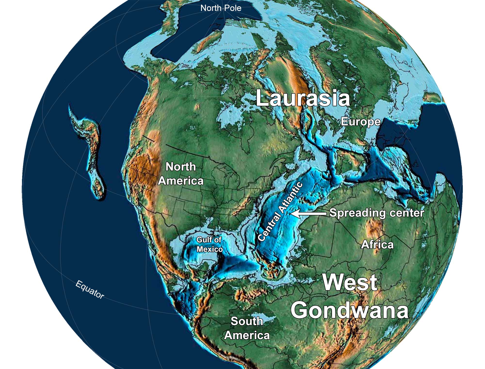
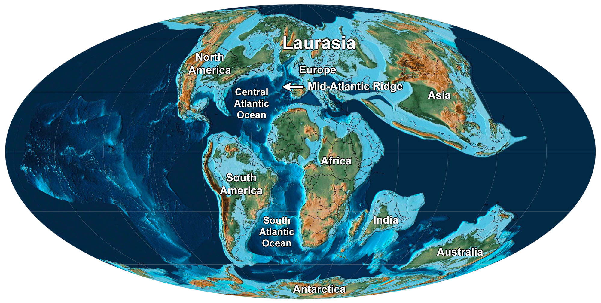
Earth 150 million years ago, near the end of the Jurassic Period. North America and Europe are part of Laurasia, and South America and Africa are part of Gondwana. Notice that North America has separated from Africa and there is a spreading center in the Central Atlantic Ocean. Reconstruction created using Paleomap (by C. Scotese) for GPlates. Reconstruction created using basemap from the PALEOMAP PaleoAtlas for GPlates and the PaleoData Plotter Program, PALEOMAP Project by C. R. Scotese (2016); map annotations by Jonathan R. Hendricks and Elizabeth J. Hermsen for PRI's Earth@Home project (CC BY-NC-SA 4.0 license).
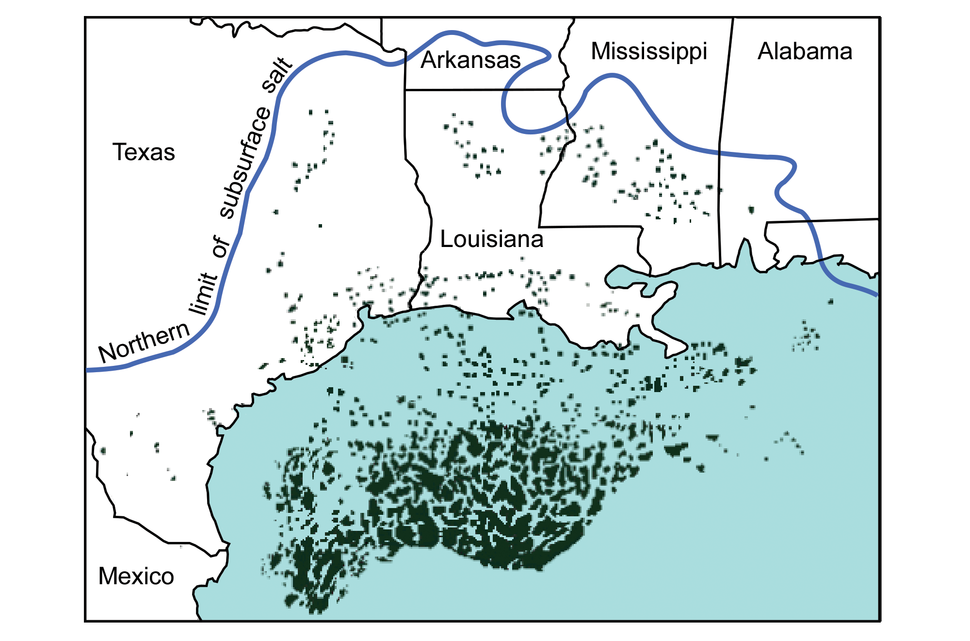
The Louann Salt Formation extends under the surface of the Coastal Plain to the blue line. The black "blobs" are known salt structures where the salt layer has been deformed. Image modified from original by Peter Nester for the Earth@Home project.
Mountain-building, volcanism, and the Western Interior Seaway (Cretaceous to Neogene, 145 million to 2.6 million years ago)
The Farallon Plate
When the supercontinent of Pangaea came together in the late Paleozoic Era, most of the world's continents were combined into the single landmass of Pangaea. Because of this, most of the world's seawater was found in a single ocean called the Panthalassic Ocean. The Panthalassic Ocean was essentially the ancient Pacific Ocean.
By the early Jurassic period, much of the floor of the Panthalassic Ocean was made up of three large plates: the Izanagi plate in the northwest, the Farallon Plate in the northeast, and the Phoenix Plate in the south. The modern Pacific Plate first formed by seafloor spreading at the junction between these plates about 190 million years ago. Over time, the Pacific Plate continued to grow by seafloor spreading. Meanwhile, the Farallon Plate shrank in area as it was subducted beneath the western margin of Pangaea (the western margin of the present-day Americas).
The subduction of the Farallon plate played an important role in building mountains in North America during the Mesozoic and Cenozoic eras. Today, remnants of the Farallon Plate include the Juan de Fuca, Cocos, and Nazca plates that exist along the western margin of the Americas.
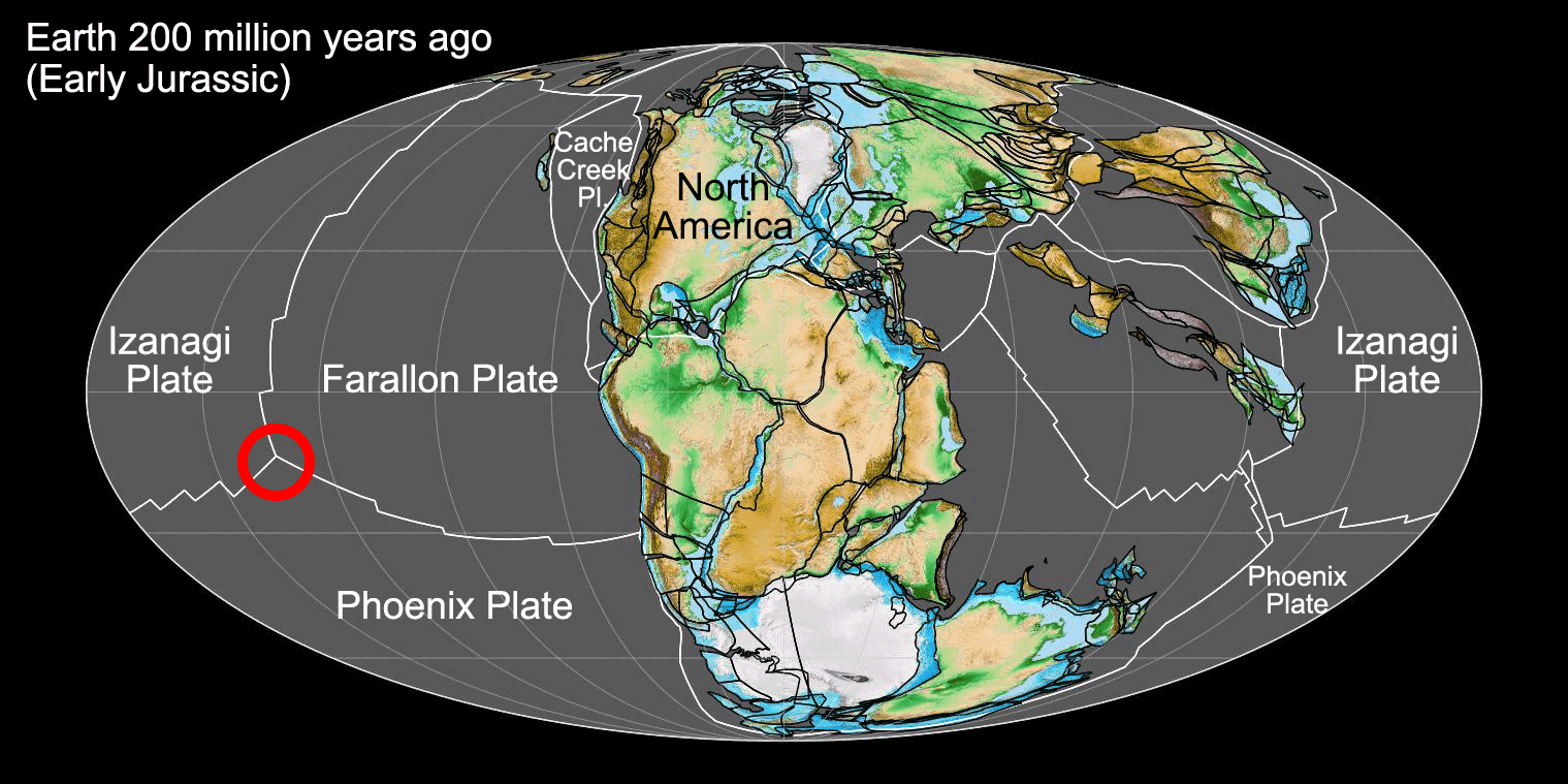
Earth 200 million years ago, showing Pangaea and the ancient Panthalassic Ocean (or the ancient Pacific). At this time, Earth's continents were combined into the supercontinent Pangaea. The floor of Panthalassa was largely made up of three plates, with the Farallon Plate bordering the western coast of ancient North America. The Pacific Plate, which makes up much of the floor of the modern Pacific ocean, originated at the junction between the Farallon, Izanagi, and Phoenix plates during the Jurassic Period (shown by the red circle on the map). Map by Fama Clamosa (Wikimedia Commons, Creative Commons Atribution-ShareAlike 4.0 International license, image cropped and labelled).
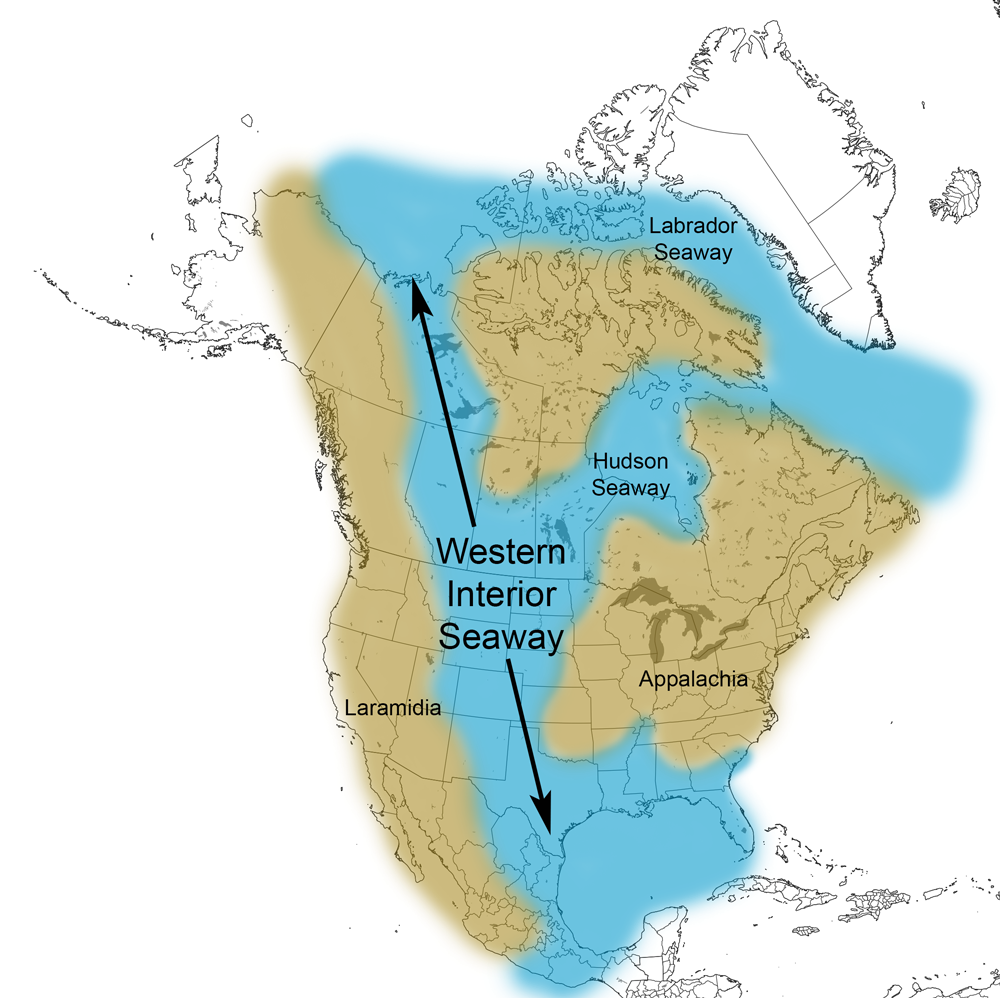
Western Interior Seaway (about 120 to 66 million years ago)
Pangaea entered its final stages of breakup during the Early Cretaceous. The oceanic crust of the Farallon Plate had been subducting under western the western margin of North America for tens of millions of years, causing a series of volcanic island complexes to collide with and become accreted to that margin of the continent. The great weight of the resulting mountains, west and north of the south-central U.S., caused the surrounding crust to sink, creating a foreland basin inland of the mountains. By 115 million years ago, the Arctic Ocean had begun to flood the basin from the north, and by around 100 million years ago, the Western Interior Seaway had formed. The Western Interior Seaway was a continuous seaway extending from the Arctic Ocean to the Gulf of Mexico.
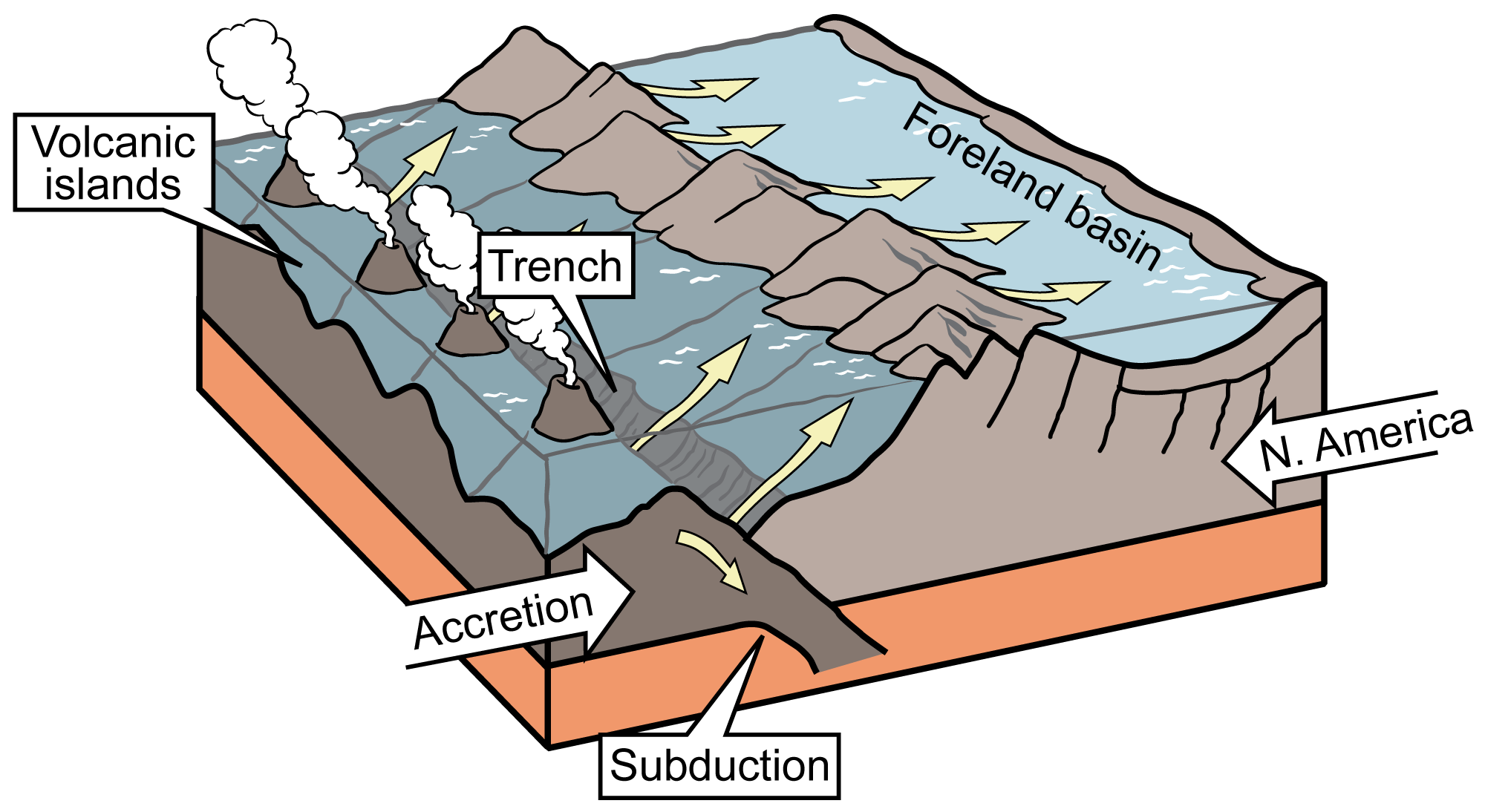
Formation of North America's foreland basin. Illustration by Jim Houghton, originally published in the Teacher Friendly Guide to Earth Science series, modified for Earth@Home.
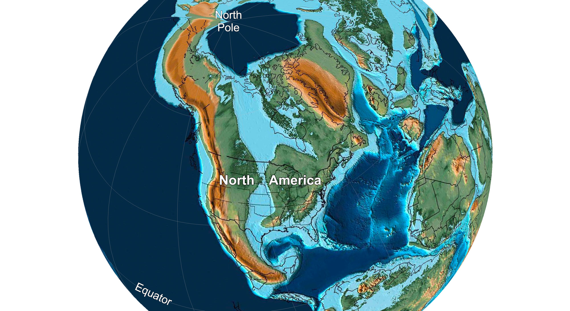
Earth 100 million years ago, in the Late Cretaceous period. The Western Interior Seaway divides the continent in two, but it has not yet reached its maximum width in the south-central U.S. Reconstruction created using Paleomap (by C. Scotese) for GPlates. Reconstruction created using basemap from the PALEOMAP PaleoAtlas for GPlates and the PaleoData Plotter Program, PALEOMAP Project by C. R. Scotese (2016); map annotations by Elizabeth J. Hermsen for PRI's Earth@Home project (CC BY-NC-SA 4.0 license).
Around 85 million years ago, the Farallon plate, began to subduct at an unusually shallow angle beneath the North American continent. It slid farther inland beneath the continent before finally sinking into the asthenosphere, downwarping the western part of the south-central U.S. This Western Interior Seaway reached its greatest extent around this time. It inundated a 1000-kilometer (620-mile) wide swath of the continent from Mexico to Alaska.
As the Farallon plate continued to collide with western North America, layers of rock were thrust up over each other, causing increasing volcanism to the west of the Western Interior Seaway. Erosion from western mountains resulted in deposition of thick layers of sediment throughout the seaway. During the very latest stages of the Cretaceous period, around 70 million years ago, the Western Interior Seaway was displaced by slow uplift of the continent and it eventually disappeared. It began filling in first in the south, cutting off the Gulf of Mexico from the more northern part of the seaway.
Rocks in the south-central U.S. are well-known for bearing fossil of organisms that lived in the Western Interior Seaway. Of particular note are fossils from the Niobrara Chalk of Kansas, which yields spectacular vertebrates like mosasaurs, plesiosaurs, giant sea turtles, pterosaurs, sharks and other fish, and birds.
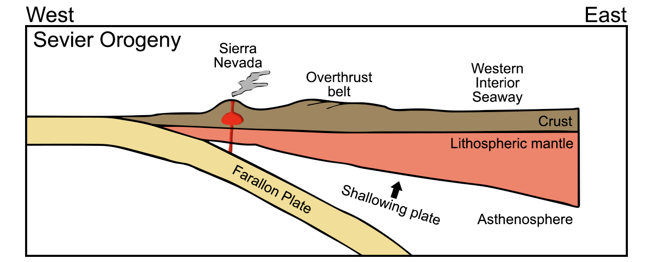
Diagram of the subduction of the Farallon plate during the Cretaceous Sevier Orogeny. The Wester Interior Seaway formed when the continental crust was downwarped in the central region of the North American continent. Diagram by Wade Greenberg-Brand, adapted from an image by the New Mexico Institute of Mining and Technology, originally published in the Teacher Friendly Guide to Earth Science series. Modified for Earth@Home.
Extent of the Western Interior Seaway during the Cretaceous Period. Image from Cretaceous Atlas of Ancient Life: Western Interior Seaway (Creative Commons Attribution-NonCommercial-ShareAlike 4.0 International license).
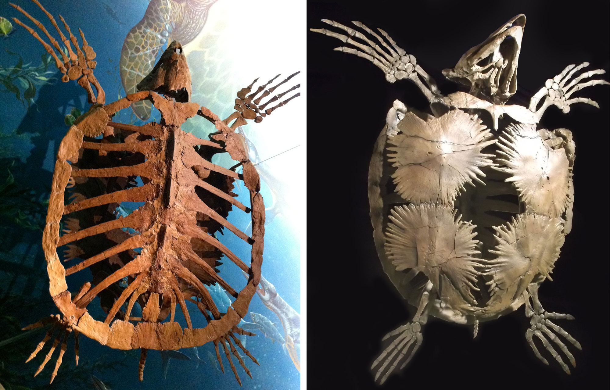
Two views of Protostega gigas, from above (left) and below (right). This turtle could grow up to about 3.7 meters (12 feet) long and weigh up to about 900 kilograms (2000 pounds)! The specimen on the left is from the Niobrara Chalk in Gove County, Kansas. The specimen on the right is a reproduction (no locality for the original given, but probably Niobrara Chalk). Photo credit, left image: RaviSarma (Wikimedia Commons, Creative Commons Attribution-ShareAlike 3.0 unported license, image cropped and resized). Photo credit, right image: McDinosaurhunter (Wikimedia Commons, Creative Commons Attribution-ShareAlike 3.0 unported license, image cropped and resized).
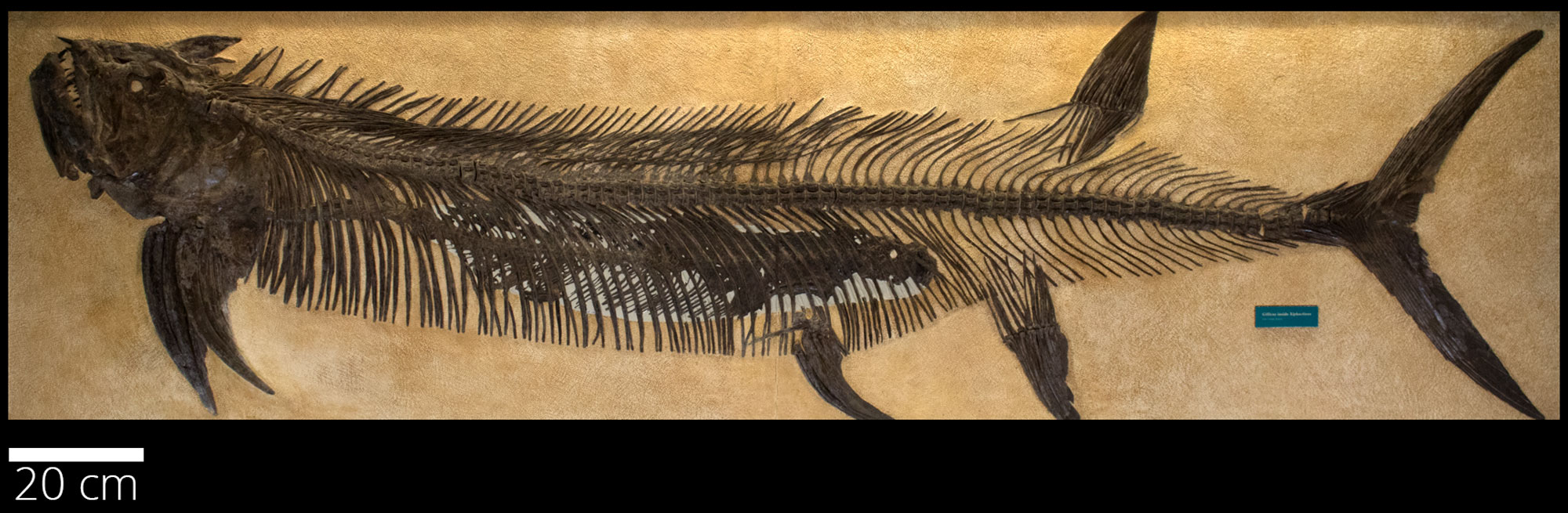
Large fish (Xiphactinus audax) with a small fish preserved in its gut. This famous "fish-within-a-fish" specimen was excavated by the fossil collector George Sternberg from the Niobrara Chalk, Gove County, Kansas, in 1952. It is on display at the Sternberg Museum in Fort Hayes, Kansas. Photo of FSHVP 333 from Cretaceous Atlas of Ancient Life: Western Interior Seaway (Creative Commons Attribution-NonCommercial-ShareAlike 4.0 International License).
Laramide Orogeny (about 85 million to 55 million years ago)
The Laramide Orogeny occurred in the Late Cretaceous and Paleogene periods, about 85 to 55 million years ago (sources vary on the exact dates, but agree that it spans the later Late Cretaceous and much of the Paleogene). This mountain-building event changed the face of the United States. The Laramide Orogeny was caused when Farallon plate began subducting at a shallower angle. This formed mountains farther inland than would normally be expected above a subduction zone, uplifting the Rocky Mountains in Wyoming, Colorado, and New Mexico.
In the early stages of the orogeny, the rising ancestral Rocky Mountains provided sediment to the remains of the Western Interior Seaway, preserving an amazing variety of organisms. By the end of the Cretaceous period about 66 million years ago, the seaway was nearly gone. The now-exposed terrain—the flat floor of the former sea—provided the foundation for the topography of the Interior Plains.
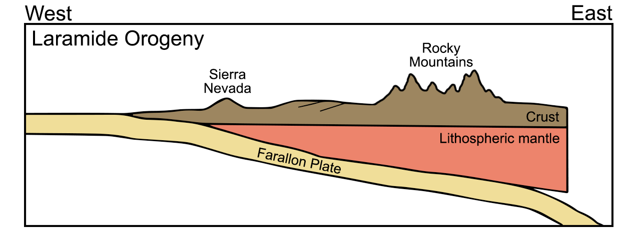
Diagram of the subduction of the Farallon plate during the Late Cretaceous to Paleogene Laramide Orogeny. During this orogeny, the Western Interior Seaway closed and the Rocky Mountains were uplifted. Diagram by Wade Greenberg-Brand, adapted from an image by the New Mexico Institute of Mining and Technology, originally published in the Teacher Friendly Guide to Earth Science series. Modified for Earth@Home.
Volcanic activity and Basin and Range (50 to 2.6 million years ago)
Volcanic activity increased around 50 million years ago, which produced large quantities of sediment that was subsequently transported and deposited across the Interior Plains. Lava was also produced, which covered portions of westernmost Texas.
By the Neogene, the Farallon plate lay shallowly under the North American plate for hundreds of kilometers eastward of the West Coast. Now situated more fully beneath what are now the south-central, southwestern, and Rocky Mountain states, this extra layer of crust caused uplift and extension of the region, as the added thickness of buoyant rock (relative to the mantle) caused the entire area to rise isostatically.
The Farallon plate was subjected to increasing temperatures as it subducted, which caused it to expand. As heat dissipated to the overlying North American plate, the rock making up that plate expanded as well. Finally, the high temperatures in the upper mantle caused the Farallon plate to melt, and the resulting magma was injected into the North American plate, destabilizing it. These processes caused the surface of the North American plate to pull apart and fault into the mountainous blocks of the huge Basin and Range province, a portion of which is found in West Texas.
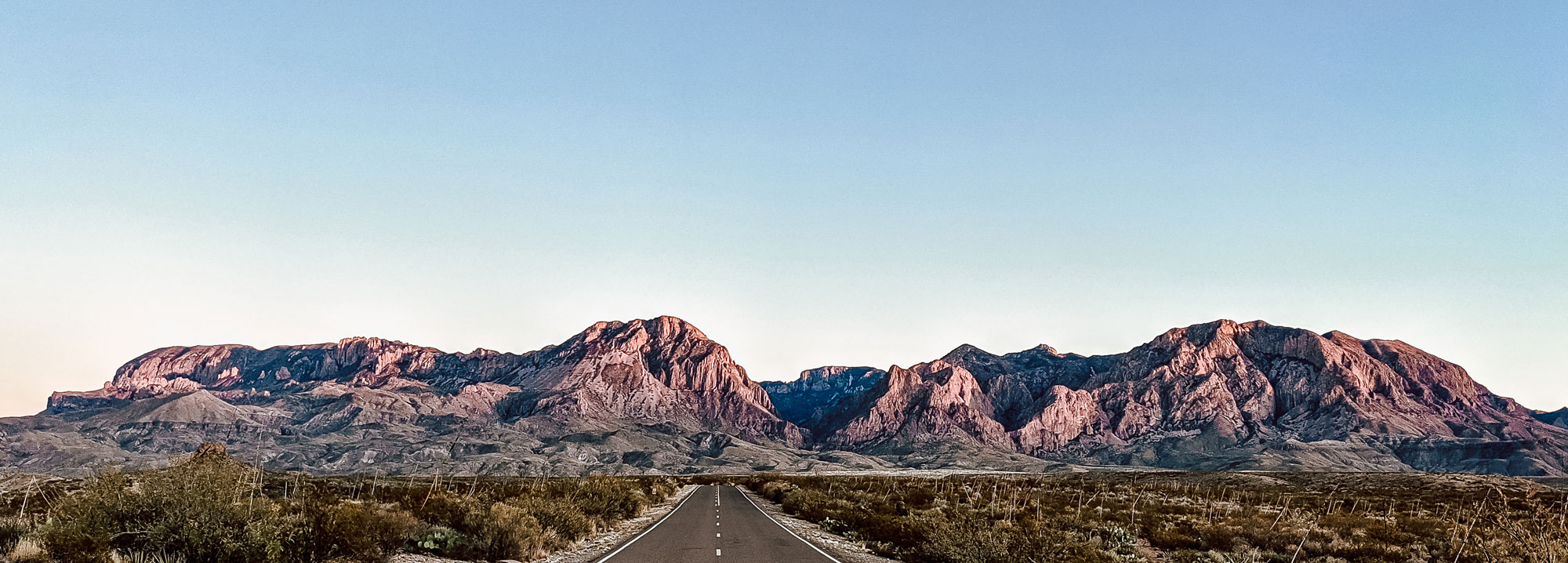
The Chisos Mountains, Big Bend National Park, Texas. These mountains originated due to volcanic activity in the Paleogene. Photo by Will Roman (Wikimedia Commons, Creative Commons Attribution-Share Alike 4.0 International license, image cropped and resized).
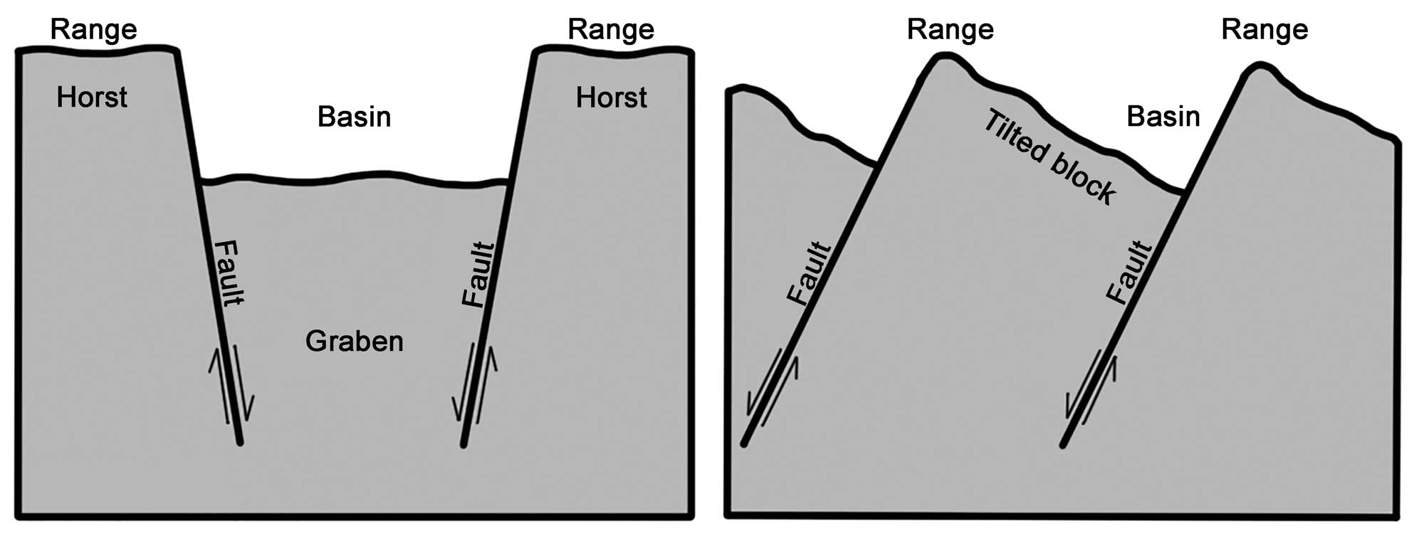
Alternating basins and ranges were formed during the past 17 million years by gradual movement along faults. Arrows indicate the relative movement of rocks on either side of a fault. Image modified from original by Wade Greenberg-Brand, in turn adapted from an image by the USGS (public domain).
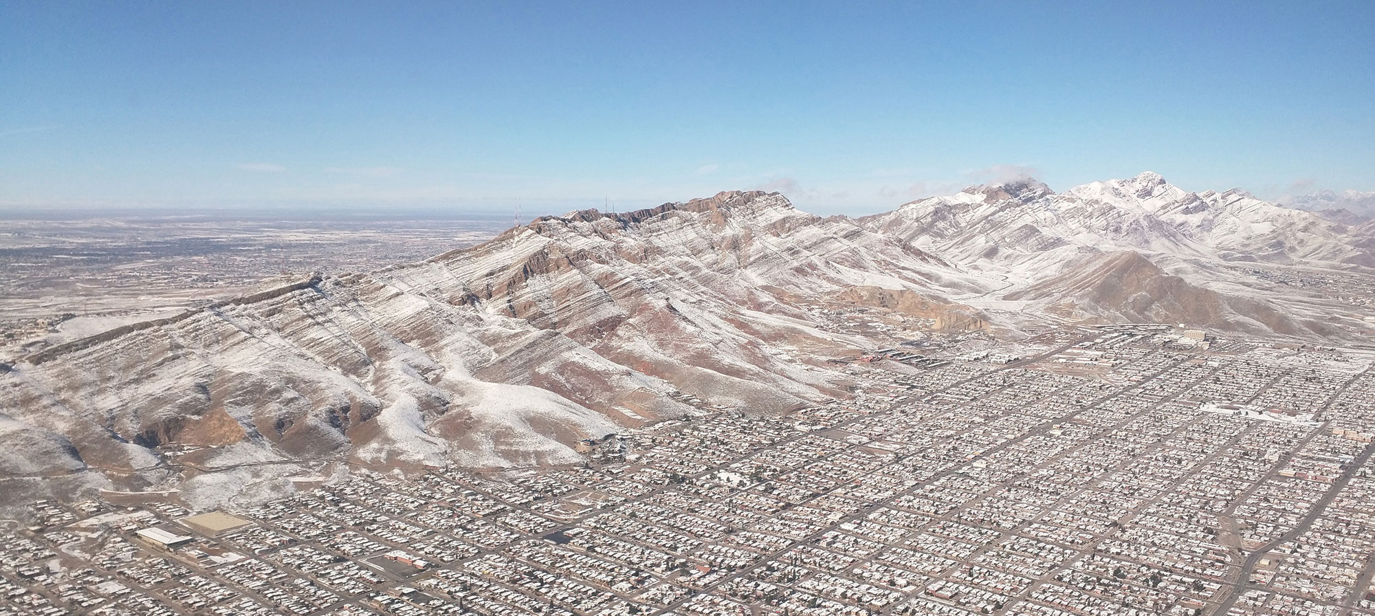
The Franklin Mountains, part of the Basin and Range province in Texas, with a dusting of snow. The city at the base of the mountains is El Paso. Photo by Dicklyon (Wikimedia Commons, Creative Commons Attribution-Share Alike 4.0 International license, image cropped and resized).
Formation of the Coastal Plain (100.5 million years ago to present)
The Coastal Plain of the south-central U.S. is the largest and generally youngest region. Its geology is also relatively straightforward: sediment eroded in the north and west since the Cretaceous has been transported and deposited on the shores of the Gulf of Mexico. In fact, the Coastal Plain’s outermost portion marks the approximate shoreline of the Gulf during the Cretaceous. Over the subsequent 70 million years, sediment from the west and north has filled in the Gulf, pushing the shore roughly 300 to 800 kilometers (190 to 500 miles) east and south to its current position, with sediment deposits 15,000 to 18,000 meters (49,000 to 59,000 feet) thick.
The depositional settings that formed the Coastal Plain are similar to those seen today, including river, floodplain, shoreline, delta, and shallow marine environments. The region is still an active environment of deposition, and deposits become increasingly younger toward the Gulf.
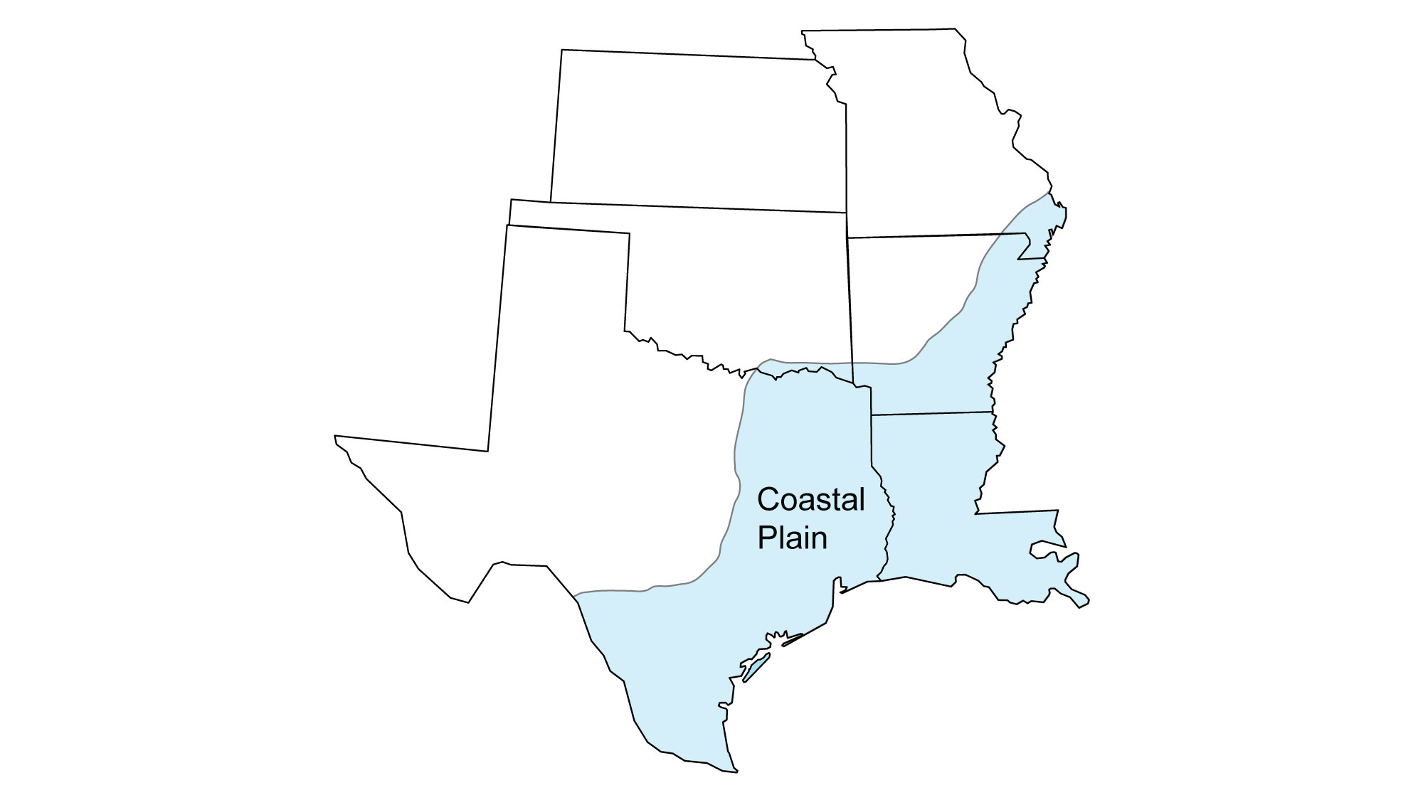
The location of the Coastal Plain in the south-central U.S.
Origin of the Mississippi Embayment
By 115 million years ago, the Arctic Ocean had flooded the basin from the north, eventually reaching the northwestern tip of Kansas. Beginning 95 million years ago, North America passed over a hot spot in the mantle. The rising magma uplifted a portion of the Ouachita-Appalachian Mountains, creating an arch and causing the range to be preferentially weathered.
After the south-central U.S. passed over the hot spot, the crust there had thinned significantly, and it began to cool and subside, eventually forming a basin. As the ocean flooded the area between the Interior Highlands and the Appalachians, the Mississippi Embayment was created.
The Mississippi Embayment area today extends from the confluence of the Ohio and Mississippi Rivers in the north, to the Gulf of Mexico in the south. This is the origin of the relatively low, flat area that now separates the Appalachian and Ouachita mountain ranges.

North America in the Late Cretaceous, about 75 million years ago, showing the flooded Mississippi Embayment region. Reconstruction created using basemap from the PALEOMAP PaleoAtlas for GPlates and the PaleoData Plotter Program, PALEOMAP Project by C. R. Scotese (2016); map annotations by Elizabeth J. Hermsen for PRI's Earth@Home project (CC BY-NC-SA 4.0 license).
Origin of Coastal Plain sediments
The Late Cretaceous was marked by high sea levels worldwide, in part due to the significant increase in plate tectonic activity that followed the break up of Pangaea. As Pangaea split apart, it changed the shape of the Earth’s ocean basins. Specifically, spreading centers formed where oceanic plates were diverging from one another. These spreading centers created underwater ridges such as the Mid-Atlantic Ridge, where new oceanic crust continues to form today. The subsequent displacement of ocean water by these ridges and the upwelling of magma associated with them contributed to higher sea levels. When sea levels rose, marine sediment was deposited on the Coastal Plain.
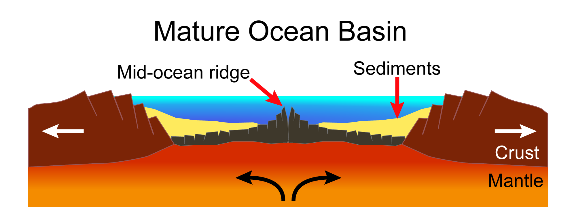
Mature ocean basin. As the pieces of the continent continue to separate, new oceanic crust is formed at a mid-ocean ridge. Modified from a diagram by Hannes Grobe (Wikimedia Commons, Creative Commons Attribution-ShareAlike 2.5 Generic license).
Earth 80 million years ago, during the Late Cretaceous Period, Molleweide projection. North America and Eurasia make up Laurasia, whereas the Gondwana continents have begun to drift apart. Reconstruction created using Paleomap (by C. Scotese) for GPlates. Reconstruction created using basemap from the PALEOMAP PaleoAtlas for GPlates and the PaleoData Plotter Program, PALEOMAP Project by C. R. Scotese (2016); map annotations by Elizabeth J. Hermsen for PRI's Earth@Home project (CC BY-NC-SA 4.0 license).
Uplift of mountain ranges in the Cretaceous also contributed sediment to the Coastal Plain. Sediment from highland regions was transported to the coast by rivers and streams, building up successive layers that fanned out onto the continental shelf. The coastal plains of south and west Texas formed as sediment washed off the still-growing Rockies. Farther east, watersheds originating in the Appalachians deposited sediment on the shores of the Gulf.
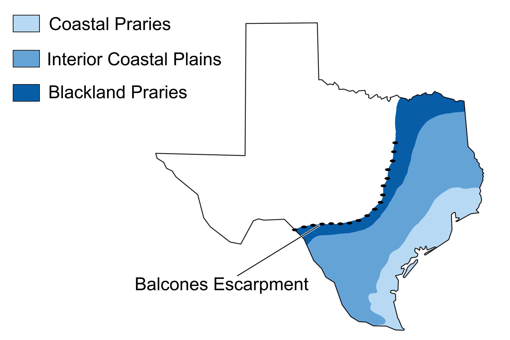
In Texas, the Coastal Plain extends west to the Balcones Fault and Escarpment, commonly regarded as the division between upland and lowland Texas. This relatively low-stress fault is thought to have formed 15 million years ago as a result of the Coastal Plain having “settled” relative to the bedrock of the upland (part of the Great Plains region), but it occasionally still generates small earthquakes.
The entire state of Louisiana is found within the Coastal Plain, where Cenozoic deposits formed as the sea advanced and retreated on several occasions. The huge volume of sediment deposited by the Mississippi River helped to build the greatest breadth of the Coastal Plain, which stretches approximately 800 kilometers (500 miles) from southeastern Missouri to the Mississippi Delta.
Physiographic map of the Coastal Plain region of Texas. Image modified from original by Wade Greenberg-Brand, which in turn is adapted from image by the Bureau of Economic Geology, University of Texas at Austin.
Quaternary (2.6 million years ago to present)
At the start of the Quaternary period, about 2.5 million years ago, continental ice sheets began to form in northernmost Canada. Throughout this period, the northern half of North America has been periodically covered by continental glaciers that originated in northern Canada. The Quaternary period is divided into two epochs: the Pleistocene and Holocene.
During the Pleistocene, ice sheets advanced south and retreated north several dozen times. The Holocene epoch is the most recent (and current) period of retreat, called an interglacial interval. The most recent glacial advance in North America reached its maximum extent 25,000–18,000 years ago, while the beginning of the Holocene is considered to be 11,700 years ago, or about 9700 BCE.
The entire United States was affected by the cooling climate during the most recent ice age. The direct influence of continental glaciers upon the surface of the south-central U.S. is limited because even during the most extreme intervals of Pleistocene glaciation, the Laurentide ice sheet barely reached as far south as northern Missouri and Kansas. During this time, the ice advanced as far south as the Missouri River, and the meltwater from the glaciers likely cut through the landscape to form the river’s original valley. Glacial deposits that exist in Missouri and Kansas can be difficult to date to a specific glacial advance and are simply labeled as pre-Illinoian, an interval covering from 1.8 million to 302,000 years ago.
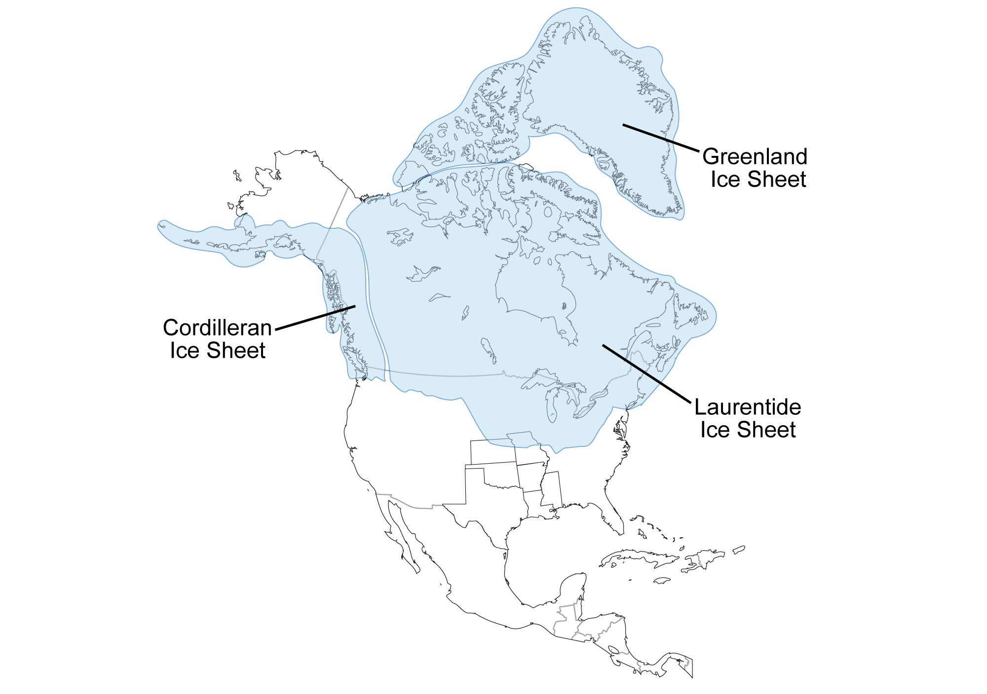
Southernmost extent of glaciation over North America, at a time when glaciers covered parts of northern Kansas and Missouri. Map by Wade Greenberg-Brand, adapted from an image by the Illinois Geological Survey, originally published in The Teacher-Friendly Guide to the Earth Science of the South Central US, modified for Earth@Home.
Evidence that continental glaciers extended southward into northeastern Kansas and northern Missouri includes quartzite erratics, glacial till, glacial lake deposits, and loess. The ice advanced as far south as the Missouri River, and the meltwater from the glaciers likely cut through the landscape to form the river’s original valley.
The predominant effects of the Pleistocene ice age on the Coastal Plain were the rise and fall of sea level, subsequent erosion and deposition, and changes in weather, drainage patterns, and the distribution of plant and animal species. At the peak of the last glacial maximum, sea level dropped more than 100 meters (328 feet) below the current level. Widely fluctuating sea levels drastically affected the erosion and deposition of sediment on the Coastal Plain, creating scarps and river terraces and steepening stream gradients, which resulted in more rapid streambed erosion.
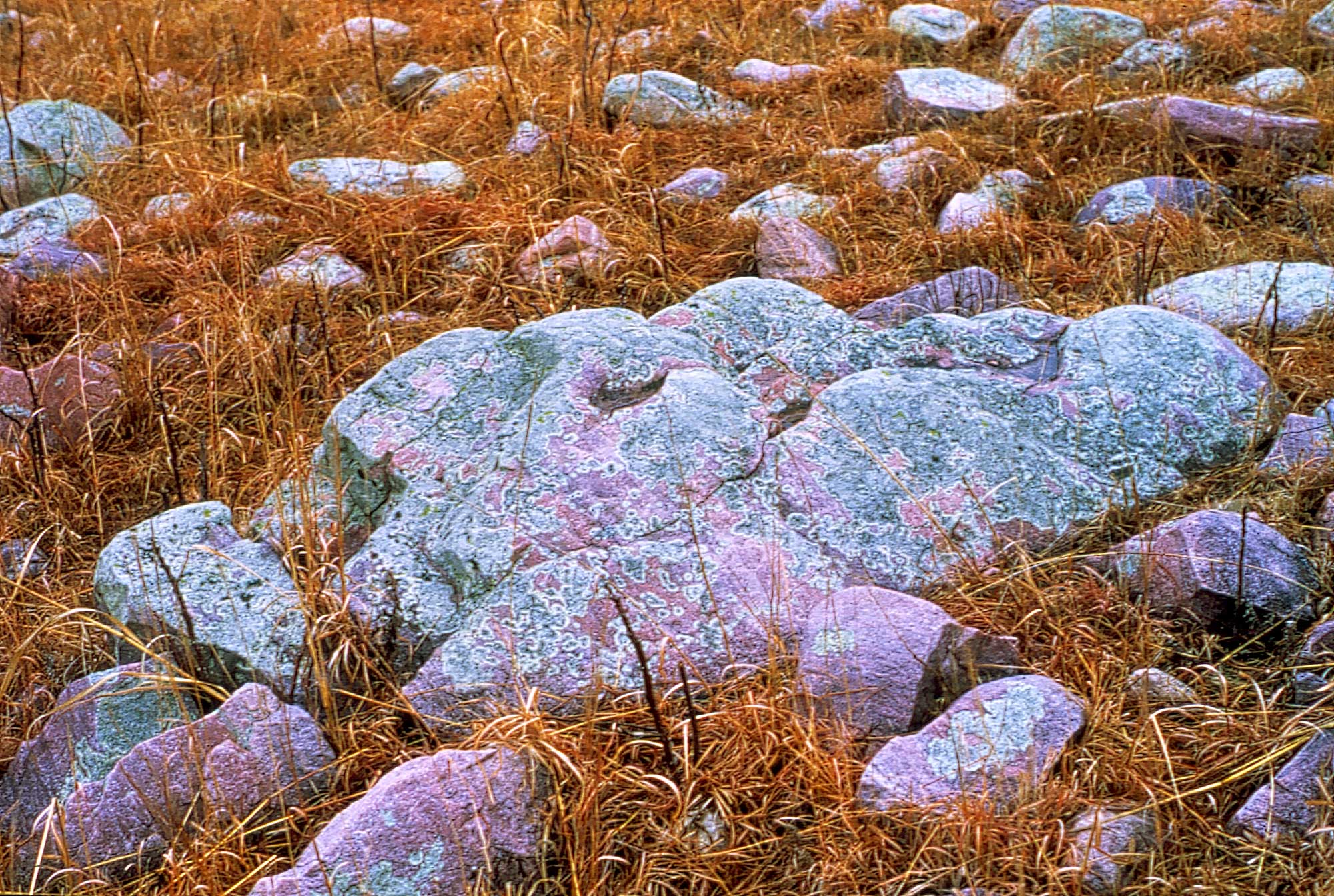
Sioux quartzite erratic boulders (boulders transported and dropped by glaciers), Wabaunsee County, Kansas. Photo by John Charlton, Kansas Geological Survey/KGS (used for non-commercial educational purposes following KGS terms of use).
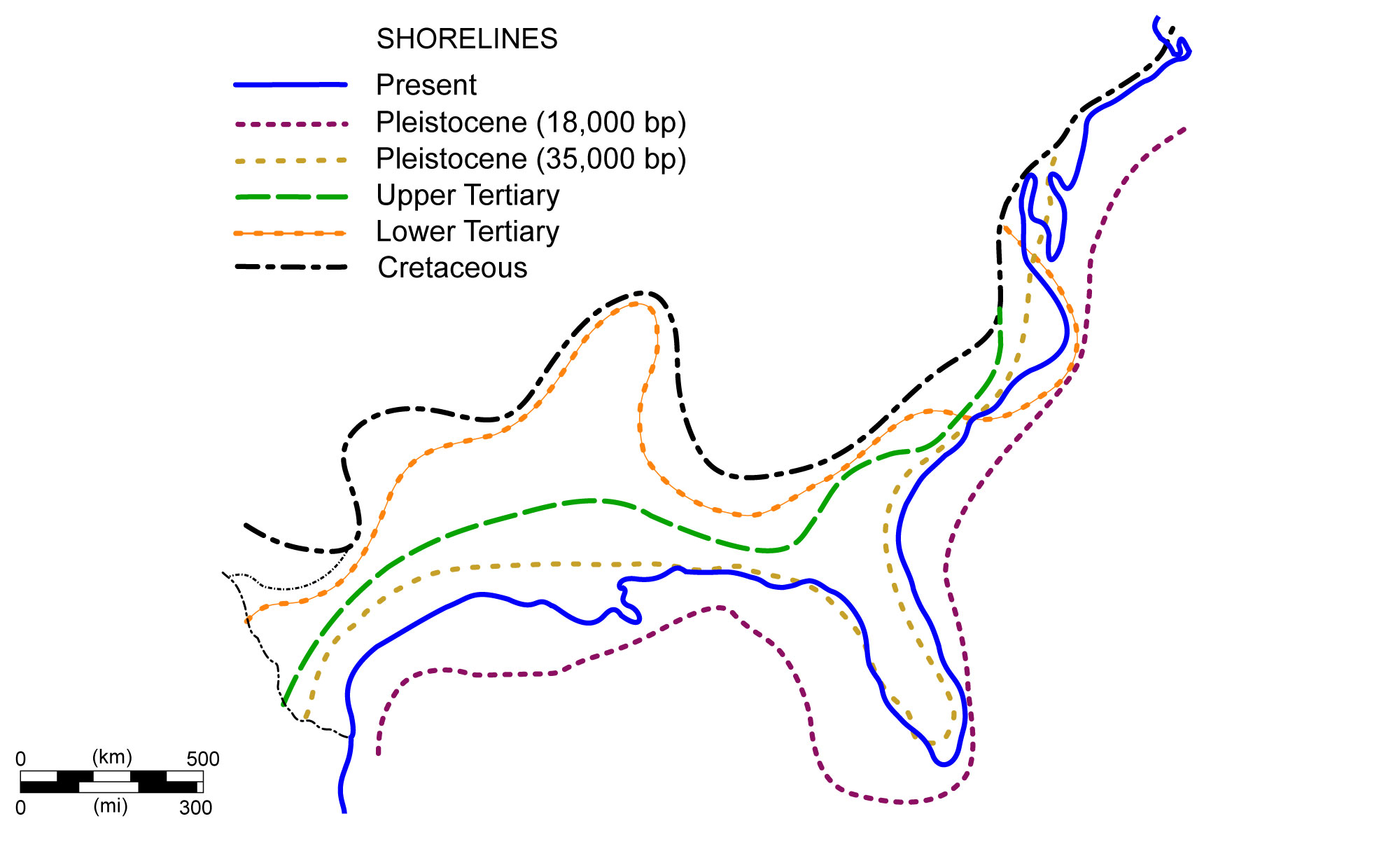
Shoreline positions along the Coastal Plain during the past 70 million years. Image modified from original by NOAA (Wikimedia Commons; public domain).
Glaciers also indirectly affected the majority of the south-central U.S. in a variety of ways. Meltwater from the north was filled with sediment that accelerated erosion, carving most of the region’s modern river valleys into the landscape. As the flowing water approached the coast and slowed, it dumped its load of sediment, helping to build the Coastal Plain out into the Gulf of Mexico. Quaternary-aged floodplains along the banks of the Mississippi and Missouri Rivers are composed of a significant amount of glacial sediment. Rock flour from these floodplains was blown by the wind, covering much of Missouri and Mississippi in layers of loess. Deposits of this silt provide the foundation for the rich soils that exist in much of the central United States. Glacial meltwater and sediment also constructed the outermost 80 kilometers (50 miles) of the Coastal Plain, especially the Mississippi Delta. Nearly all of Louisiana’s surface is Neogene- or Quaternary-aged, unconsolidated or semi-consolidated sediment deposited by water.
The ice age continues today, but the Earth is in an interglacial stage, since the ice sheets have retreated for now. The current interglacial period has slowed both erosional and depositional processes in the south-central U.S.—this and a higher, more stable sea level allowed coastal features such as barrier islands and lagoons to form, resulting in the landscape we know today. The glacial-interglacial cycling of ice ages indicates that the world will return to a glacial stage in the future, but the impacts of human-induced climate change might radically shift the direction of these natural cycles.
Resources
Resources from the Paleontological Research Institution
Earth@Home: Here on Earth: Introduction to Plate Tectonics: https://earthathome.org/hoe/plate-tectonics