

Snapshot: Overview of the topography of the Central Lowland region of the South-Central United States, including portions of Missouri, Kansas, Oklahoma, and Texas.
Topics covered on this page: Overview; Kansas and Missouri; Oklahoma and Texas; Resources.
Credits: Most of the text of this page is derived from "Topography of the South Central US" by Richard A. Kissel and Alex F. Wall, chapter 4 in The Teacher-Friendly Guide to the Earth Science of the South Central US, edited by Mark D. Lucas, Robert M. Ross, and Andrielle N. Swaby (published in 2015 by the Paleontological Research Institution). The book was adapted for the web by Elizabeth J. Hermsen and Jonathan R. Hendricks in 2021–2022. Changes include formatting and revisions to the text and images. Credits for individual images are given in figure captions.
Updates: Page last updated February 7, 2022.
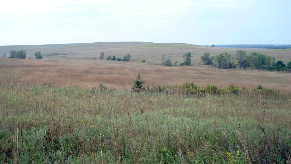
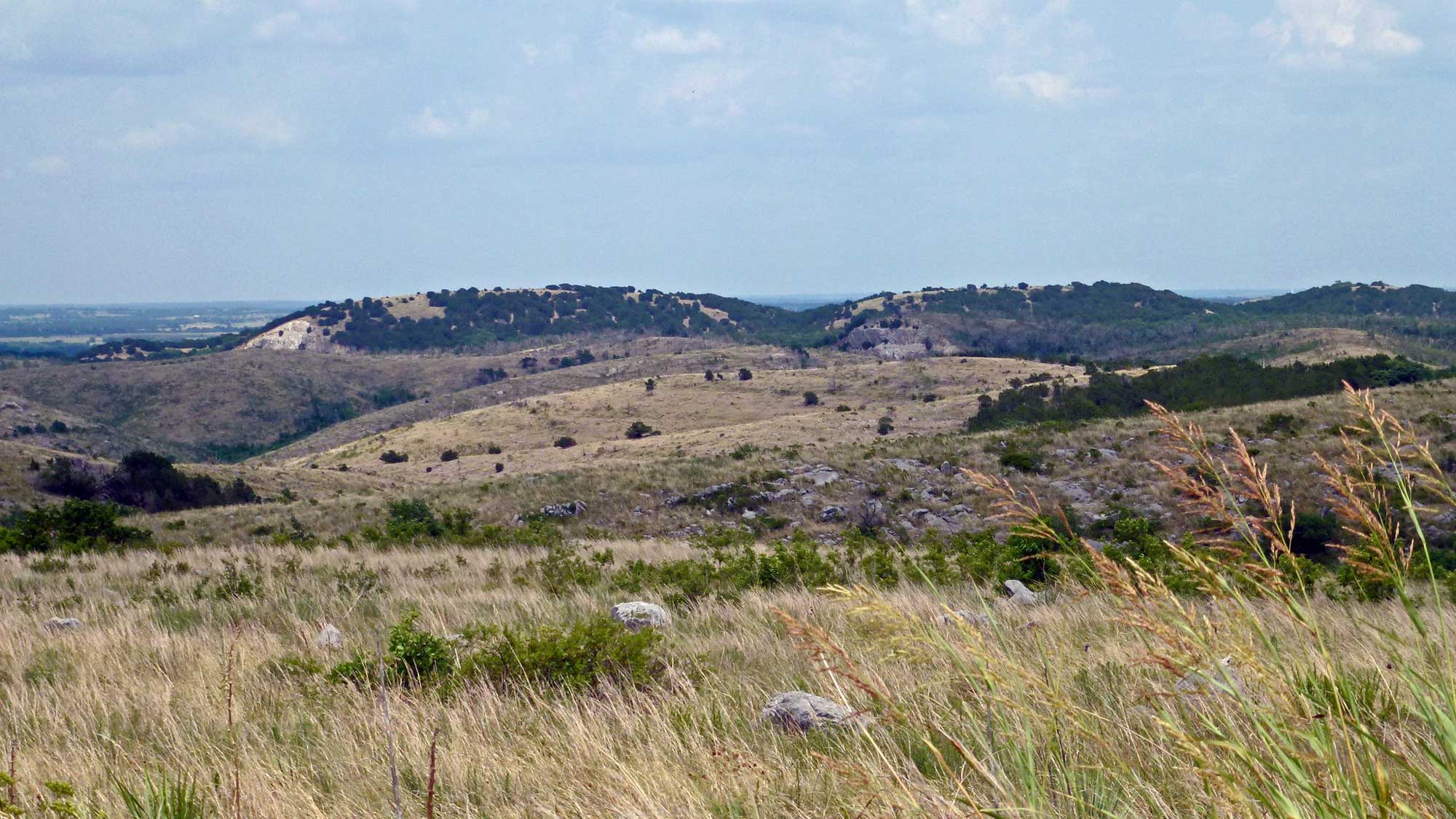
Image above: Photograph of the Flint Hills at the Tallgrass Prairie National Preserve, Kansas. Photograph by Jonathan R. Hendricks.
Overview
The Central Lowland is part of the Interior Plains of the United States, bounded by the Great Plains to the west. This region was affected by glaciation, with its northernmost areas smoothed during the glacial advances of the most recent ice age.
Kansas and Missouri
During the Quaternary, a 152-meter (500-foot) thick ice sheet from the extensive Kansan glacial stage (a sub-stage of the Pre-Illinoian glaciation) covered Kansas’ northeastern corner as well as Missouri’s northern third.
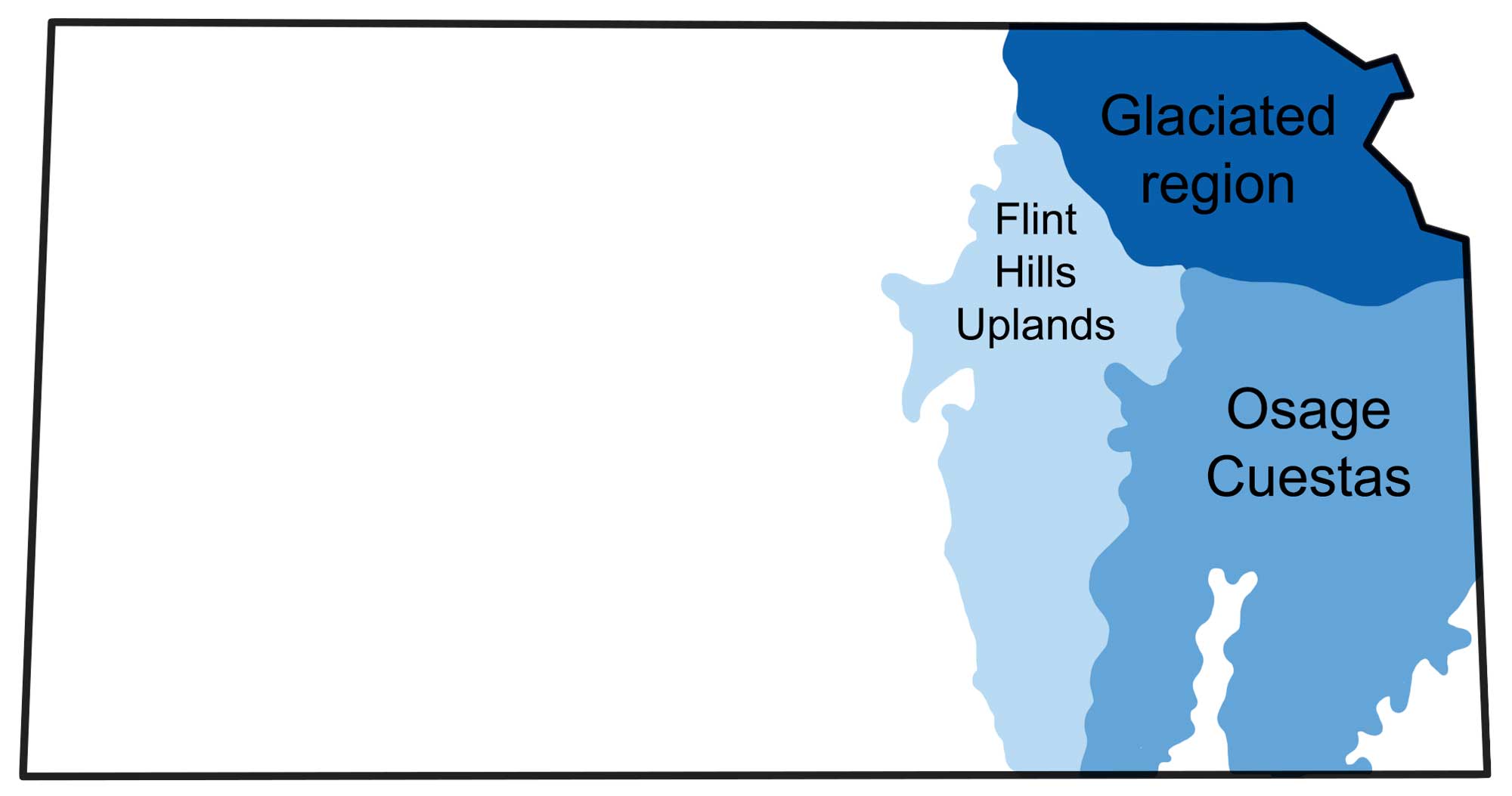
Physiographic areas of Kansas within the Central Lowland. Image modified from original by Wade Greenberg-Brand, in turn adapted from image by the Kansas Geological Survey.
Glacial scouring flattened the landscape, leaving behind smooth, rolling hills. The ice sheet also left behind layers of till, clay, gravel, and wind-blown silt (called loess), which contributed to the area’s rich soil. These glacial deposits are underlain by shales and limestones that formed in a shallow sea during the late Paleozoic. While most evidence of the glaciers’ advance has already been erased by erosion, glacial erratics―large boulders of red quartzite carried from as far north as South Dakota―are prevalent throughout the Central Lowland’s glaciated area. In Wabunsee County, Kansas, whole ridges are composed entirely of such boulders. These ridges may have originally been valleys that filled up with the erratics, which in turn were more resistant to erosion than the surrounding rock—meaning that erosion eventually broke down the valley walls, leaving behind a ridge of the boulders that had once filled the valley. This phenomenon is called topographic inversion.
In Kansas, south of the glacial deposits, the Osage Cuestas area is characterized by a series of east-facing escarpments formed by gently dipping Paleozoic limestones and shales. The combination of resistant limestone and more easily eroded shale led to the formation of the cliffs we see today, whose steep faces range from 15 to 60 meters (50 to 200 feet) in height.
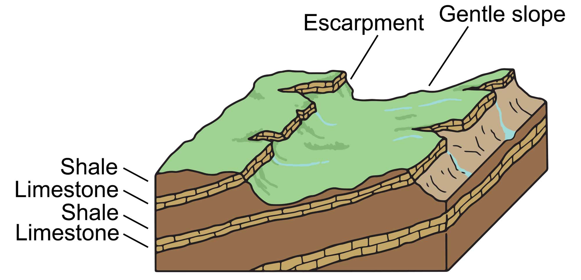
The escarpment topography of the Osage Cuestas is composed of alternating, gently dipping layers of soft shales and hard limestones. Image modified from original by Wade Greenberg-Brand, in turn adapted from image by the Kansas Geological Survey.
Directly west of the Osage Cuestas lie the Flint Hills, which are also composed of erosion-resistant limestone alternating with softer shales.
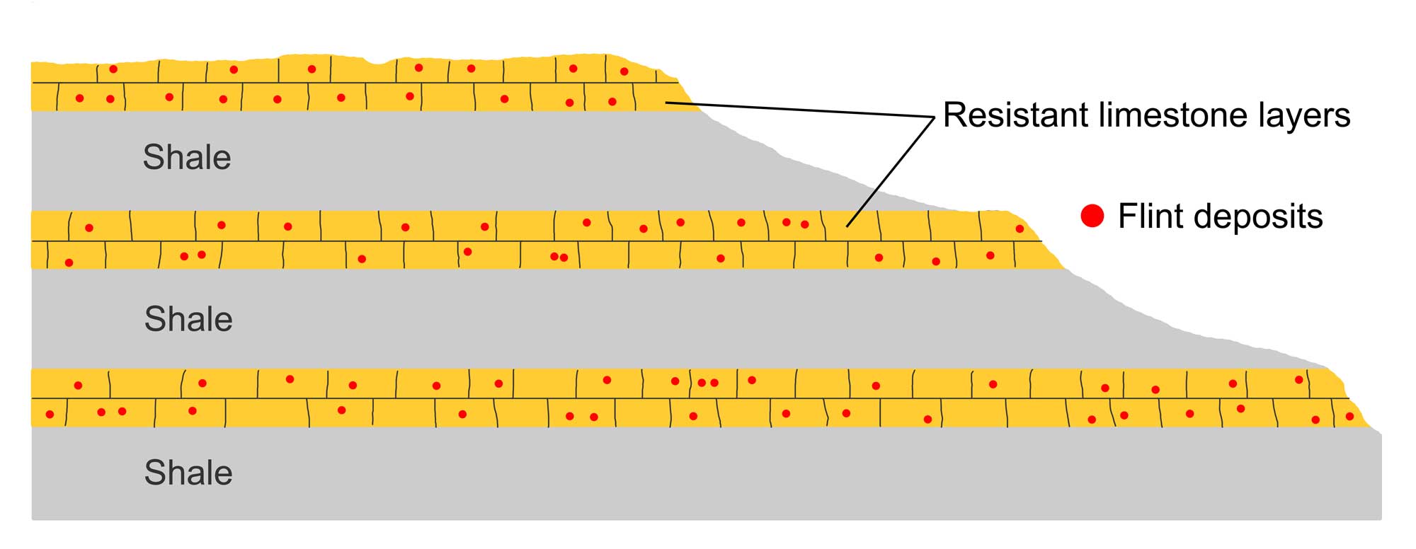
Differential erosion led to the Flint Hills’ unique, stairstep landscape. Image by Jonathan R. Hendricks for the Earth@Home project, based on original by the National Park Service (public domain).
Unlike the gently sloping strata of the Cuestas, the rocks of the Flint Hills lie in flat layers—here, differential erosion has led to a stair-stepped landscape. The Flint Hills also differ from the Cuestas in that their limestone layers contain hard nodules of chert (also called flint), which further enhances the limestone’s resistance to erosion. Karst features such as sinkholes, caves, and springs are common in the Flint Hills.
Oklahoma and Texas
The Central Lowland of Oklahoma and Texas, also known in part as the Osage Plains (Oklahoma) and the North-Central Plain (Texas), is an area of rolling terrain and prairies. These landscapes began to form during the Paleozoic, when an inland sea covered the region. Tectonic activity has played a minimal role in altering the region, so the area’s largely flat topography was preserved after the sea receded.
The Arbuckle Mountains in south central Oklahoma are one exception.
The Arbuckle Mountains, Oklahoma. Photograph by Granger Meador (Flickr; Creative Commons Attribution-NonCommercial 2.0 Generic license; image cropped and resized).
This low mountain chain formed as the land buckled and folded into an anticline structure during the Ouachita Orogeny, which occurred to the southeast during the Carboniferous.
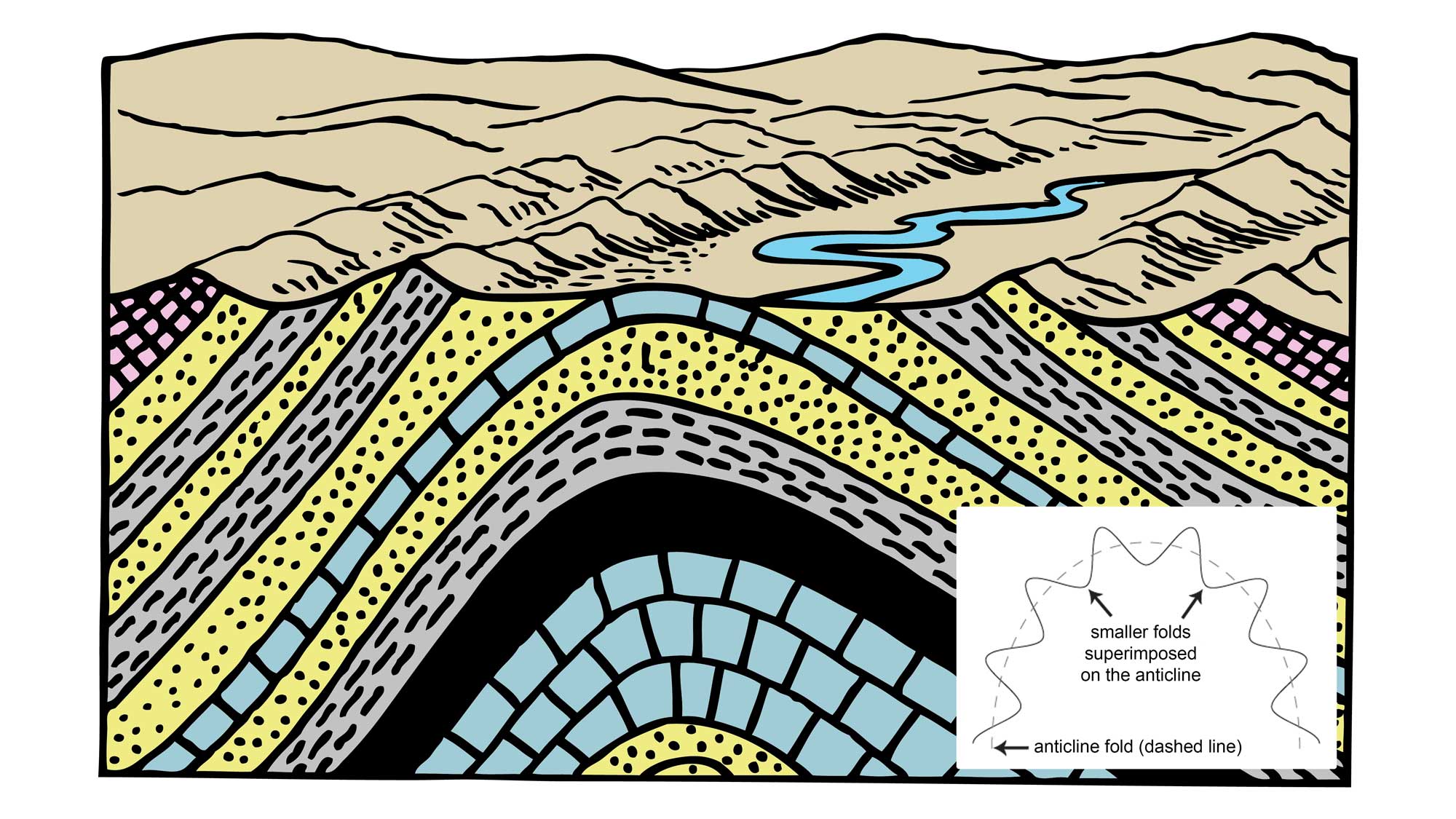
Cartoon drawing of an anticline, which is an upward fold in layered rocks. The inset image shows the structure of an anticlinorium, which is a large scale anticline composed of numerous small folds (anticlines and synclines). Cartoon drawing by Pearson Scott Foresman (Wikimedia Commons; public domain). Inset image by Jim Houghton. Both images modified for the Earth@Home project.
The Arbuckles reach heights of 90–150 meters (300–500 feet) above the surrounding terrain. Water has worked its way through fractures in the underlying limestone to create a series of more than 1000 caves and conduits that serve as a major freshwater aquifer.
Texas’ North-Central Plain is bounded to the west by the Caprock Escarpment, a cliff of erosion-resistant calcium carbonate that rises as high as 300 meters (1000 feet) above the plains.