

Page snapshot: Introduction to the geologic history of the southeastern United States from the Precambrian to the Quaternary Period.
Topics covered on this page: Grenville Orogeny (Precambrian); Breakup of Rodinia and Origin of the Iapetus Ocean (Precambrian); Taconic Orogeny (Cambrian and Ordovician); Acadian Orogeny (Silurian to Mississippian); Alleghanian Orogeny (Devonian to Permian); Breakup of Pangaea (Triassic and Jurassic); Formation of the Coastal Plain (Cretaceous to Neogene); Ice Age (Quaternary); Resources.
Credits: Most of the text of this page is derived from "Geologic history of the Southeastern US" by Warren D. Allmon, Jane A. Picconi, Stephen F. Greb, and Charles C. Smith, chapter 1 in The Teacher-Friendly Guide to the Earth Science of the Southeastern US, 2nd ed., edited by Andrielle N. Swaby, Mark D. Lucas, and Robert M. Ross (published in 2016 by the Paleontological Research Institution; currently out of print). The book was adapted for the web by Elizabeth J. Hermsen and Jonathan R. Hendricks in 2021–2022. Changes include formatting and revisions to the text and images. Credits for individual images are given in figure captions.
Updates: Page last updated March 26, 2022.
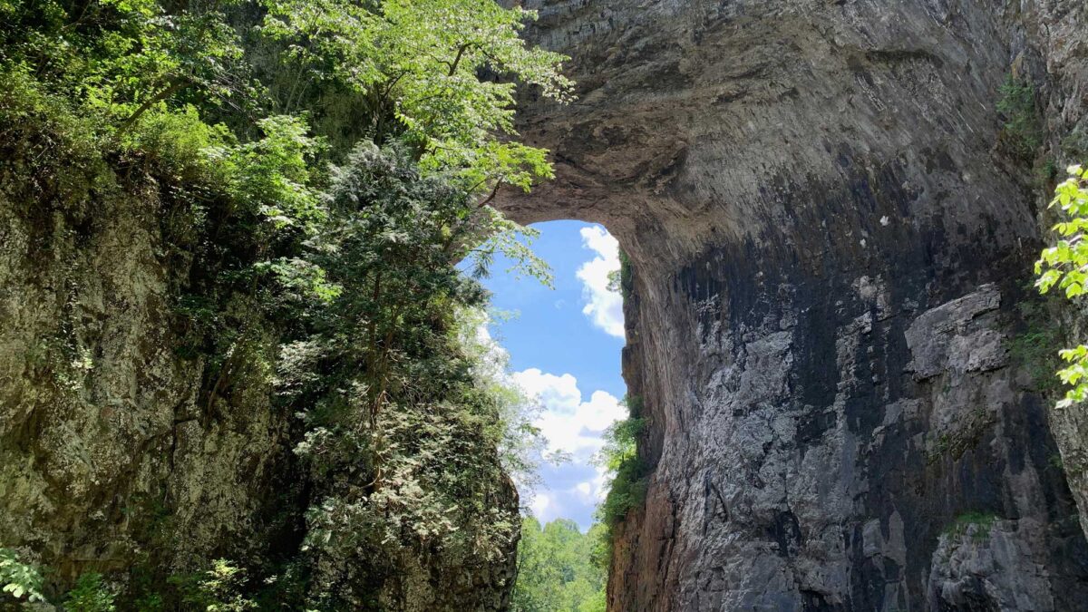
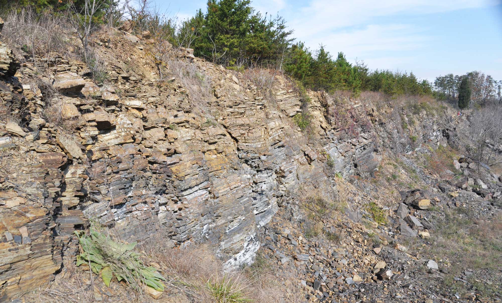
Image above: Natural Bridge, Virginia. The arch of the bridge is made up of Ordovician-aged dolomite. Photo by Elizabeth J. Hermsen.
The Big Picture
The geologic history of the Southeastern United States is a story of active mountain building and the quieter processes of weathering, erosion, and deposition of sediments. The Southeast is at the edge of the North American continent, but in the middle of the North American plate, which extends from the mid-Atlantic ridge to the West Coast. Today the Southeast is tectonically inactive, but this was not always the case. Millions of years ago, it was the site of multiple continent-continent collisions and the rifting of supercontinents. Repeated episodes of mountain building, sea level changes, and the erosion and deposition of sediment shaped the Southeast as we know it today.
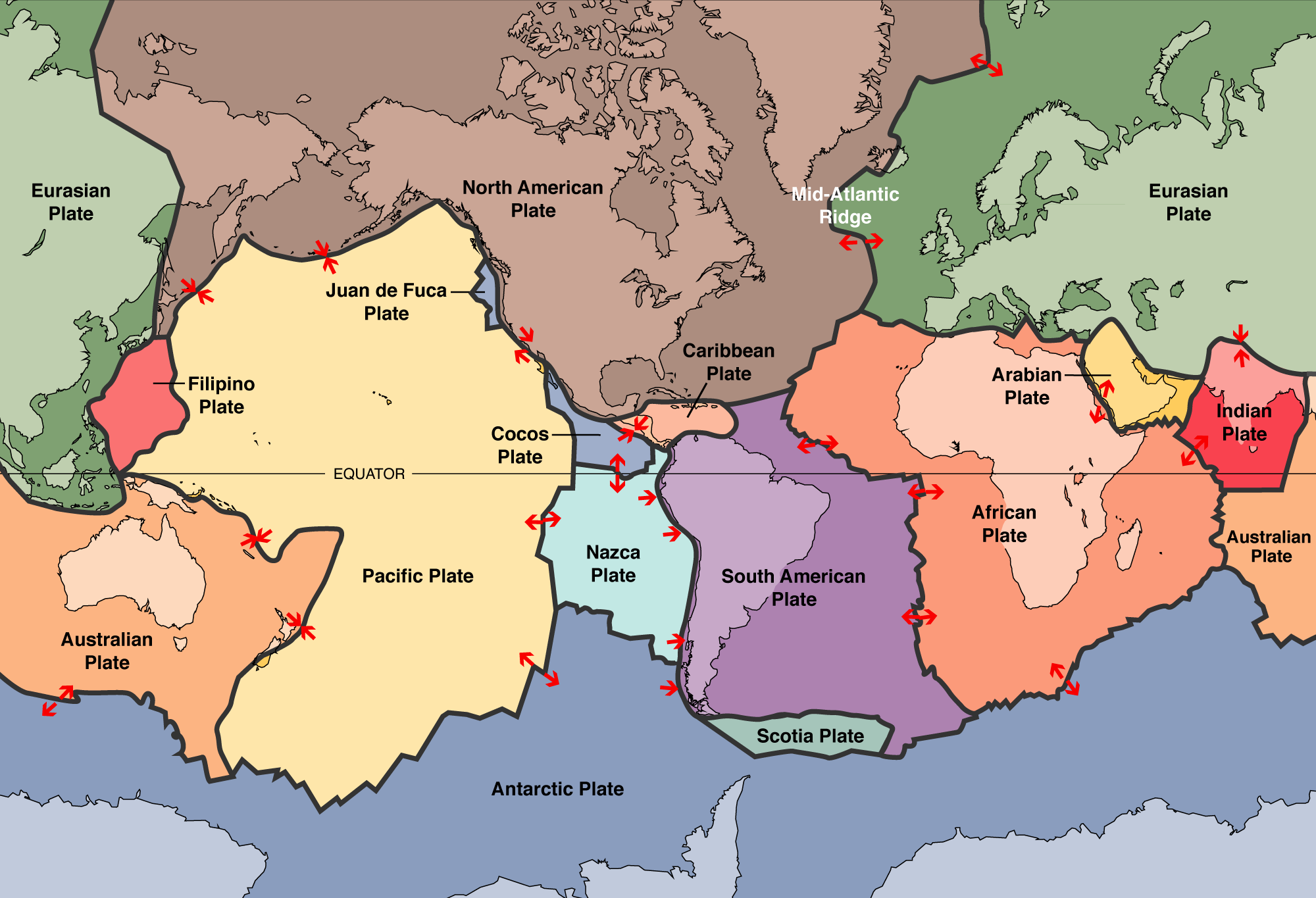
World map showing the boundaries of the tectonic plates. The North American Continent takes up only part of the North American plate (brown). The Mid-Atlantic Ridge, a spreading center (in other words, a place where plates are moving away from one another) is also labelled. The arrows indicate the directions of plate movement. Map modified from USGS tectonic plates map, via Wikimedia Commons (public domain).
In this discussion, the Southeastern states are divided into three different geologic provinces or regions: (1) the Blue Ridge and Piedmont, (2) the Inland Basin, and (3) the Coastal Plain. Each of these regions has a different geological history, and thus varies in terms of rocks, fossils, topography, mineral resources, soils, and other geological features. The Blue Ridge and Piedmont is composed of the peaks and foothills found at the southern end of the chain of mountains known as the Appalachians. This is the core or "backbone" of Southeastern geology. The Inland Basin, to the west of the Appalachians, includes a number of structural depressions that have filled with sediment, mostly eroded from the mountains. To the east and south is the Coastal Plain, a gently sloping area between the mountains and the ocean.
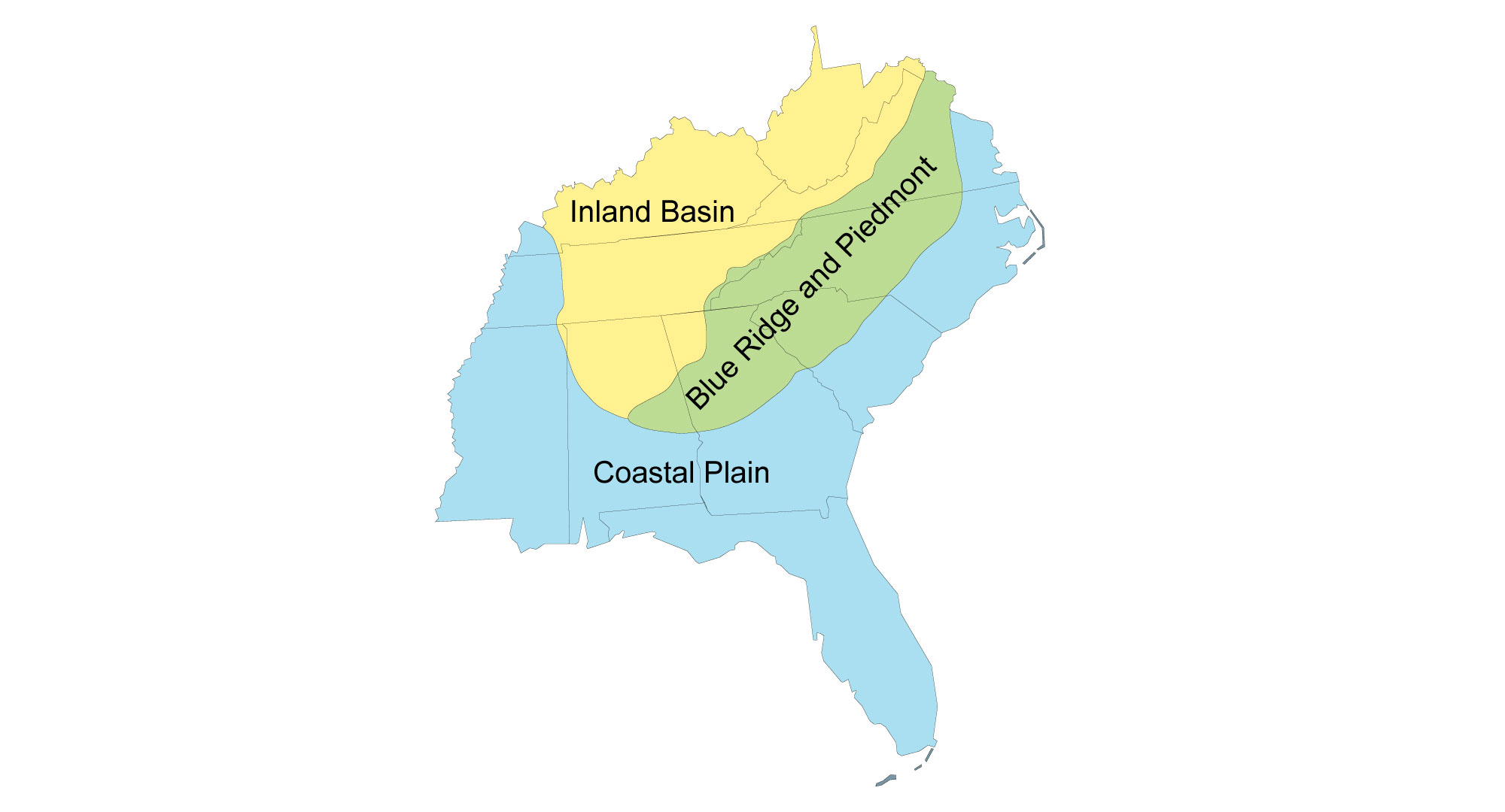
Map showing the three major geologic regions of the Southeastern US. Image modified from original by Wade Greenberg-Brand, first published in The Teacher-Friendly Guide to the Earth Science of the Southeastern US, 2nd ed., edited by Andrielle N. Swaby, Mark D. Lucas, and Robert M. Ross (published by the Paleontological Research Institution) (CC BY-NC-SA 4.0 license).
Hadean to Mesoproterozoic (4.6 to 1 billion years ago)
Hadean to Paleoproterozoic (4.6 to 1.6 billion years ago)
The Earth is estimated to be approximately 4.6 billion years old, an age obtained by dating meteorites. The oldest rocks in North America are 4.3-billion-year-old rocks found along the eastern shore of Hudson Bay in northern Quebec. These are part of the Canadian Shield, the ancient core of the North American continental landmass. A shield, or craton, is the stable core of a continent.
In Precambrian time (all of time before the Cambrian began about 541 million years ago), very little existed of the Southeast as we know it today. The rocks of the Piedmont and the basement rocks of Florida would not be attached to Laurentia (Laurentia was the proto-North American continent) until hundreds of millions of years later. The sediments that eventually solidified into the rocks of most of the present Gulf and Atlantic coastal states had not yet been deposited.
The oldest rocks exposed in the Southeast are Precambrian gneisses from Roan Mountain, on the border between North Carolina and Tennessee. These rocks are dated at more than 1.8 billion years old. They were later metamorphosed (transformed) during a major period of mountain building called the Grenville Orogeny. The name Grenville comes from a unit of metamorphosed sedimentary rocks in Quebec, Canada. It is used to refer both to the Grenville Orogeny, which is a period of mountain-building, and to Grenville rocks, or rocks that formed as a result of the Grenville Orogeny.
The Grenville Mountains (1.3 to 1 billion years ago)
The ancient Grenville rocks tell a story of repeated mountain building on North America's east coast caused by collisions between continents. The Grenville Orogeny occurred between about 1.3 and 1 billion and years ago. During the orogeny, a number of smaller continental blocks and offshore islands were added to the much older core of Laurentia. The collisions between Laurentia and these smaller landmasses caused mountains to form. They created a tall (perhaps Himalaya-scale) mountain range, the Grenville Mountains, which stretched from Canada to Mexico. The Grenville Orogeny was also one of several Precambrian continental collisions that led to the assembly of the supercontinent Rodinia, which formed between 1.4 billion and 900 million years ago. Rodinia contained most or all of Earth's landmass.
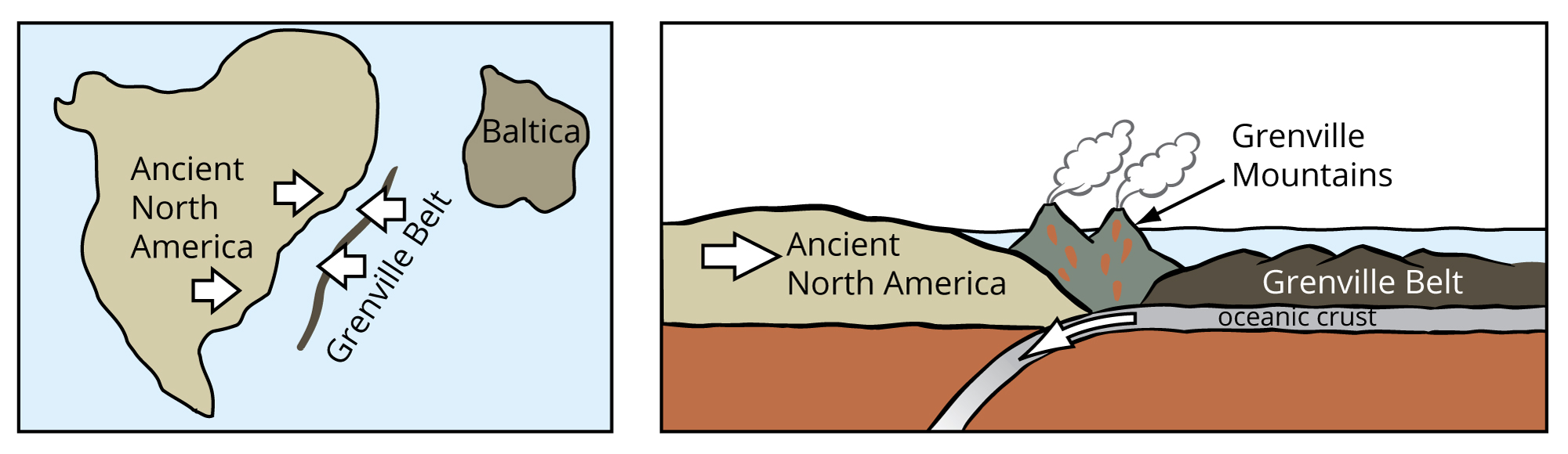
Grenville mountain building during the Precambrian. Images modified from original by J. Houghton first published in The Teacher-Friendly Guide to the Geology of the Southeastern U.S., 2nd ed., edited by Andrielle N. Swaby, Mark D. Lucas, and Robert M. Ross (published by the Paleontological Research Institution) (CC BY-NC-SA 4.0 license).
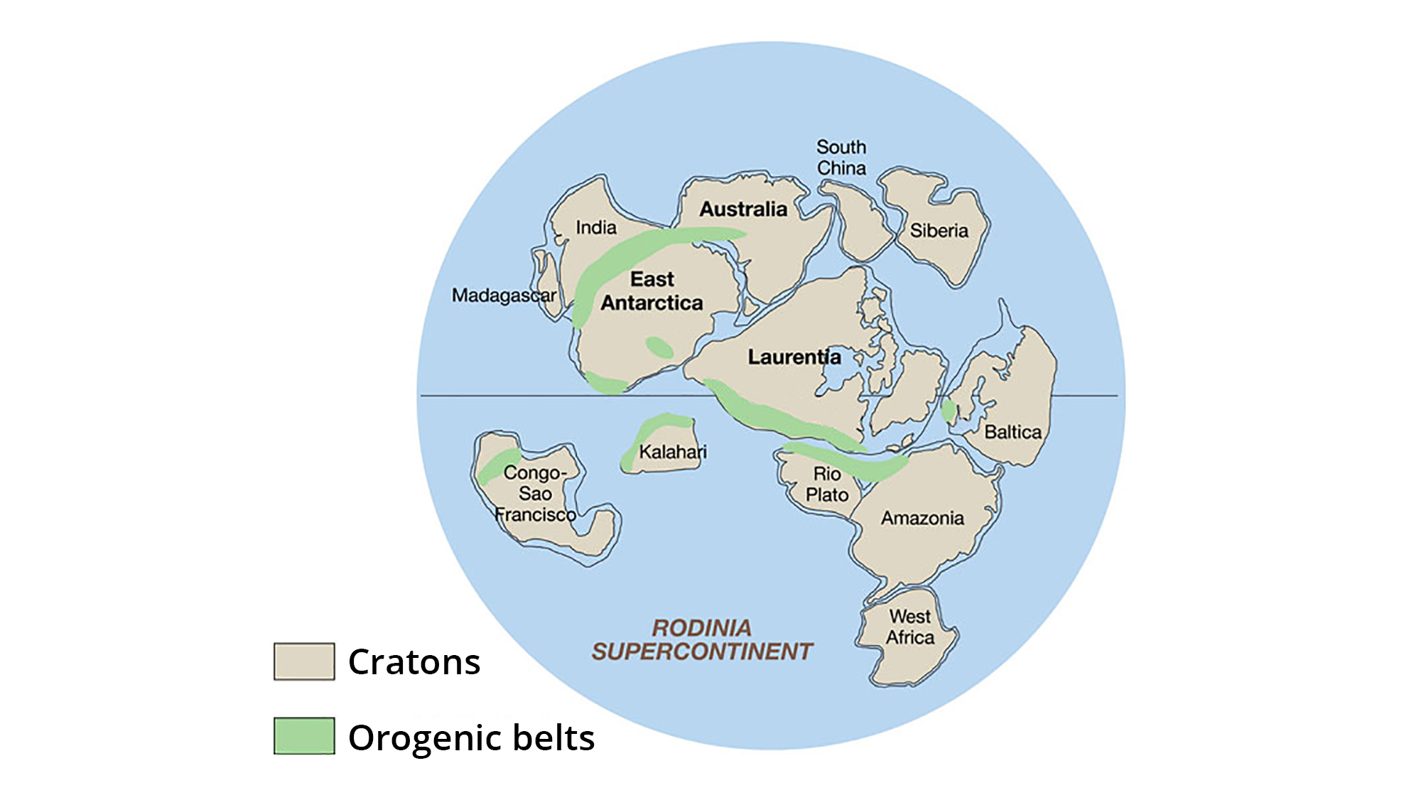
The supercontinent Rodinia, around 1.1 billion years ago. Laurentia represents proto-North America. Image adapted from original created by John Goodge for the United States Geological Survey (public domain).
Sediment that eroded from the Grenville Mountains was transported by rivers and streams across Laurentia's continental margins and into the adjacent oceans. The sediment that was deposited in the ocean waters on the eastern margin of Laurentia makes up a series of rocks called the Grenville Series (or the "Grenville Belt" in older literature).
During the Grenville Orogeny, intense heat and pressure associated with the continental collisions produced molten rock. The molten rock was injected into the crust, where it metamorphosed the sediments of the Grenville Series that had eroded from the craton. Orogenic compression folded—and even completely overturned—the metamorphosed sedimentary rocks and igneous intrusions, forming the basement rock of today's Appalachians. Basement rock forms the foundation that underlies the surface geology of an area. Basement rocks are often igneous or metamorphic crystalline rock.
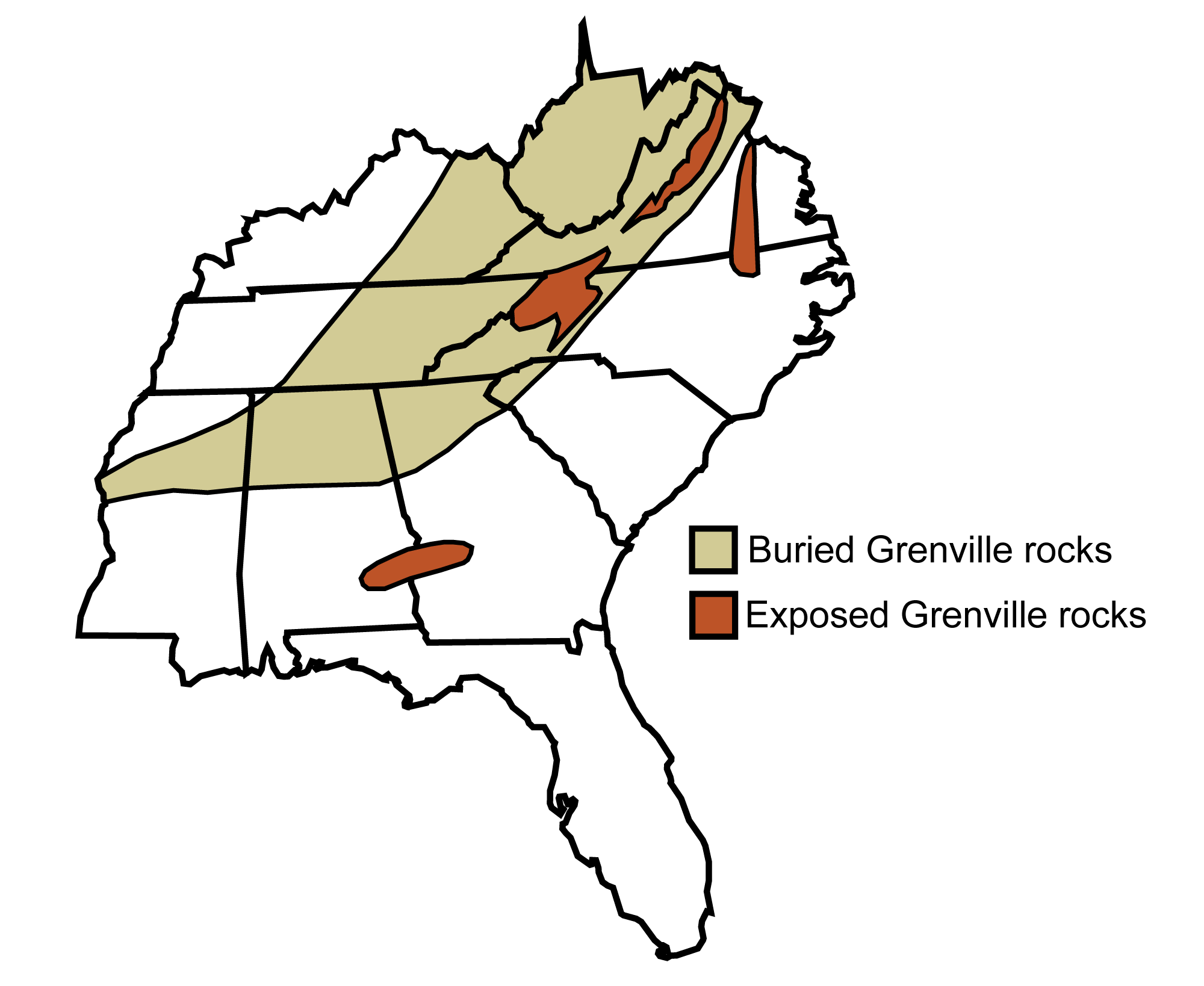
Exposures of Grenville age rocks are found up and down the East Coast and Canada. Image modified from original by Jim Houghton, first published in The Teacher-Friendly Guide to the Earth Science of the Southeastern US, 2nd ed., edited by Andrielle N. Swaby, Mark D. Lucas, and Robert M. Ross (published by the Paleontological Research Institution) (CC BY-NC-SA 4.0 license).
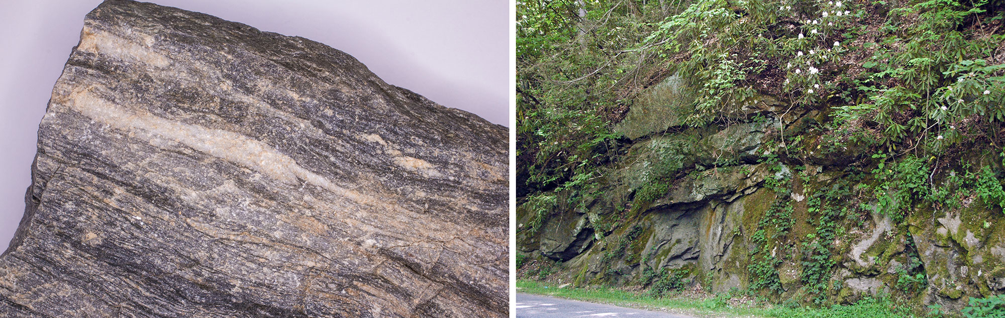
Grenville-age gneisses (a type of metamorphic rock) from the Appalachian Mountains. Left: Sample of cranberry gneiss from North Carolina. The cranberry gneiss is estimated to be more than one billion years old. Photo by Alex Wheatley (flickr, Creative Commons Attribution-NonCommercial 2.0 Generic license, image resized and cropped). Right: Outcrop of gneiss at the Mingus Mill roadcut, Great Smoky Mountains, North Carolina. This gneiss has not been dated, but is also thought to be over one billion years old. Information from and photo by James St. John (flickr, Creative Commons Attribution 2.0 Generic license, image cropped).
Weathering and erosion are constants throughout the history of time. Rocks are constantly worn down and broken apart into finer and finer grains by wind, rivers, wave action, freezing and thawing, and chemical breakdown. Over millions of years, weathering and erosion can reduce a mighty mountain range to low rolling hills.
Just as mountains continually erode today, the Grenville Mountains eroded for the next few hundred million years after their formation. In most areas, ancient Grenville rocks are now covered by thousands of meters of younger rocks. However, in the Southeast, weathering left the ancient mountain cores exposed in such places as Blowing Rock in North Carolina, Red Top Mountain in Georgia, and Old Rag Mountain in Virginia.
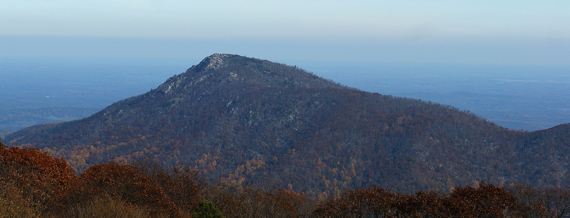
Old Rag Mountain, Virginia. Photo by Stephen Little (flickr, Creative Commons Attribution-NonCommercial 2.0 Generic license, image cropped and resized).
Neoproterozoic (1 billion to 541 million years ago)
Ancient Rifting: Breakup of Rodinia
Laurentia began to break away from the rest of Rodinia about 700 million years ago. As a result of tensional forces beneath the continental crust, a series of cracks known as rifts formed throughout the Rodinia landmass. During this time, Earth experienced the most extreme episodes of glaciation in its history. Ice sheets spread all the way into tropical latitudes.
Around 565 million years ago, the continents that made up Rodinia split apart completely at a major rift. The rift that caused the breakup of Rodinia flooded and transformed from continental to oceanic (basaltic) crust. Geologists call the ocean that filled in this rift the Iapetus Ocean. Some call it the proto-Atlantic because the modern Atlantic Ocean opened up in a similar way and position relative to modern-day North America and Europe. The rift that became the Iapetus Ocean is marked by ancient sandstone, which is visible at the top of Pilot Mountain in Surry County, North Carolina.
During the late Precambrian and early Cambrian, Laurentia was positioned near the equator. The Southeastern US was rotated roughly 90° clockwise relative to its current position so that today's east coast faced south. The lack of tectonic activity along the continent's coastline made it a passive margin, similar to the Atlantic and Gulf coasts of the US today.
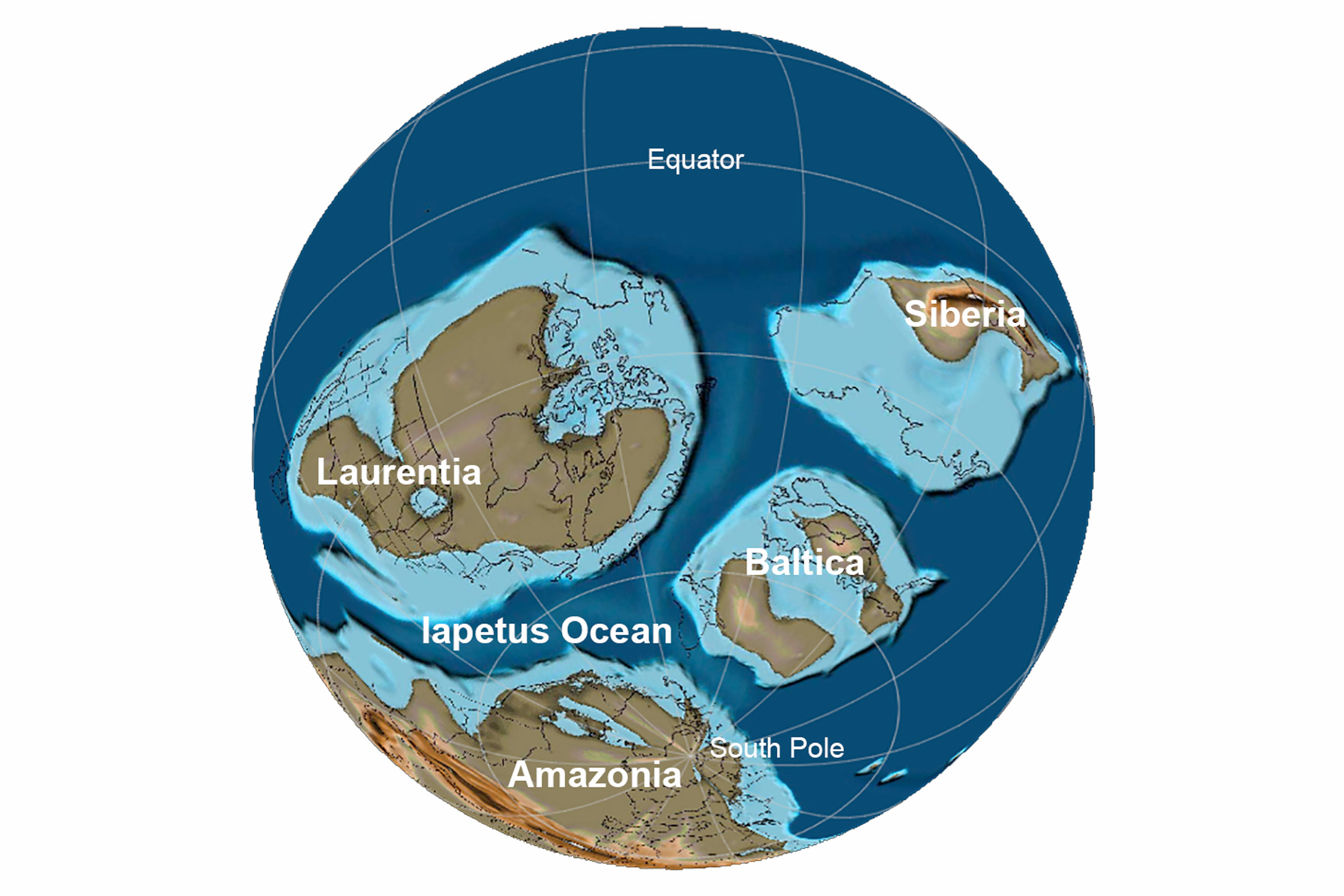
Earth at the end of the Precambrian, 565 million years ago. Laurentia is the name given to "proto-North America"; Baltica consists of modern northern European countries; Amazonia, which was part of Gondwana, includes much of modern Brazil. All of these continents were positioned south of the equator 565 million years ago. Reconstruction created using basemap from the PALEOMAP PaleoAtlas for GPlates and the PaleoData Plotter Program, PALEOMAP Project by C. R. Scotese (2016); map annotations by Jonathan R. Hendricks for PRI's Earth@Home project (CC BY-NC-SA 4.0 license).
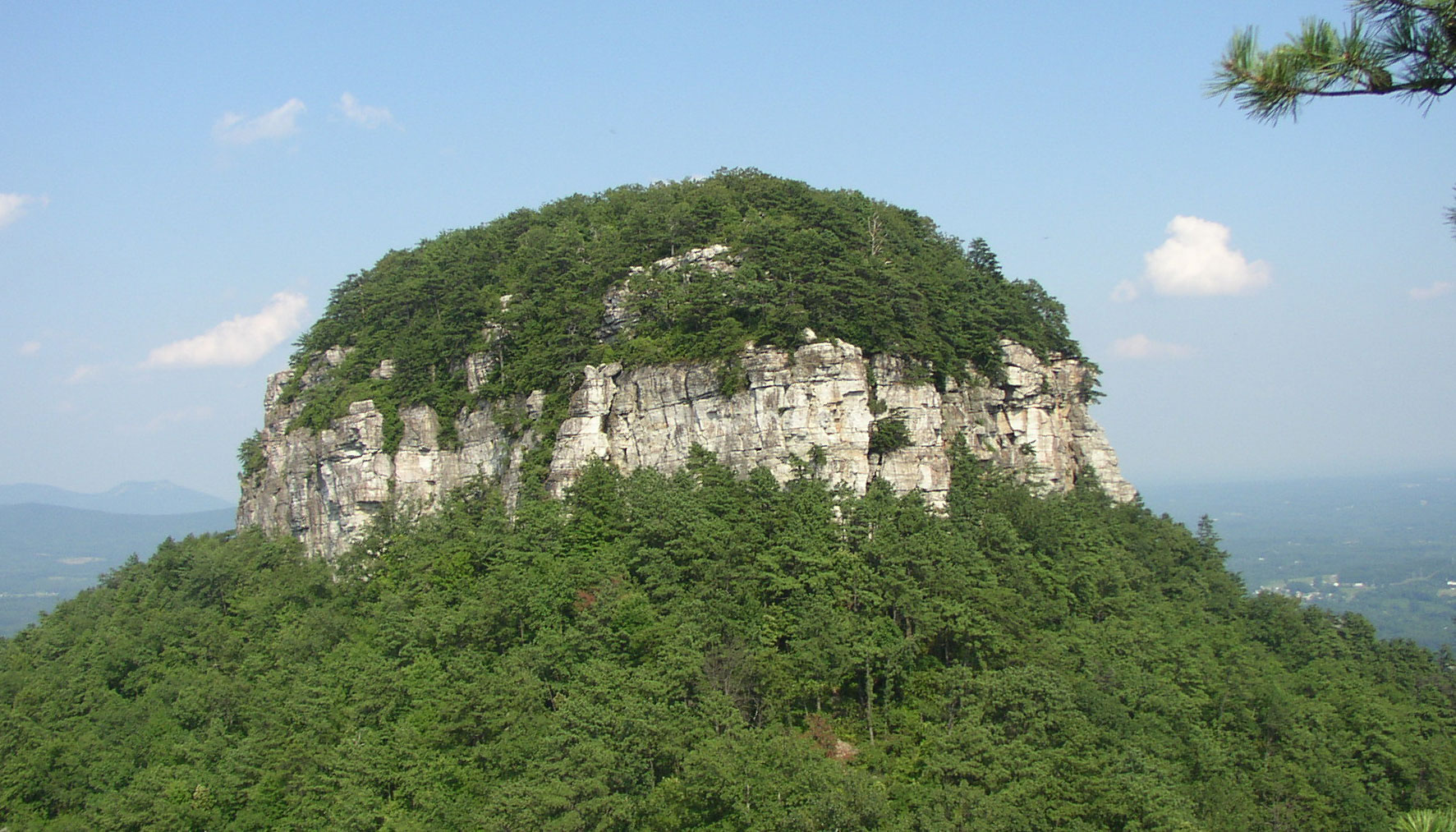
Quartzite (metamorphosed sandstone) cap on Pilot Mountain, North Carolina. Photo by AnDrew McKenzie (Wikimedia, Creative Commons Attribution-Share Alike 3.0 Unported license, image cropped).
The rifting that formed the Iapetus Ocean also created an irregular margin along the edge of Laurentia. The margin included a series of projections or promontories found in what is now Alabama, New York, and the St. Lawrence region of Quebec. It also formed embayments, which are found in what is now Tennessee, Pennsylvania, Newfoundland. The promontories received little or no sediment during the Precambrian, but the embayments accumulated thick piles of sediment from the eroding continent.
Not all of Rodinia's rifts broke completely across the continent. Instead, some of them formed rift basins within the continental crust. Rift basins occur when crustal blocks slide downward along faults (breaks in the rock) as the continental crust thins. These basins filled with sediment. Some of the sediment from Rodinia's rift basins is preserved in the rocks of Grandfather Mountain, North Carolina. Basaltic lava that welled up through cracks in the basin can also be seen near Bakersville in Mitchell County, western North Carolina.
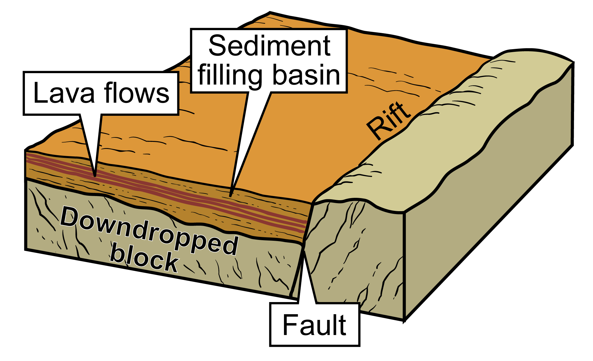
A typical rift basin. The fault is the break in the rock along which the downdropped block has slid, forming a depression known as a rift basin. Sediment begins to fill the basin as it erodes from the surrounding landscape. Magma in the form of lava flows may well up through cracks in the basin, creating layers of igneous rock (basalt). Image modified from original by Jim Houghton, first published in The Teacher-Friendly Guide to the Earth Science of the Southeastern US, 2nd ed., edited by Andrielle N. Swaby, Mark D. Lucas, and Robert M. Ross (published by the Paleontological Research Institution) (CC BY-NC-SA 4.0 license).
As the young Iapetus Ocean widened, global sea levels also rose, flooding much of Laurentia's interior with seawater. These relatively shallow epicontinental seas were sites of widespread deposition of carbonate sediment derived from the many organisms living there. These carbonate sediments formed limestones, which can be seen today in Kentucky and Tennessee. Sediments continued to erode from either side of the Grenville Mountains into the deeper Iapetus Ocean to the south (presen-day east) and the shallow inland sea to the north (present-day west).
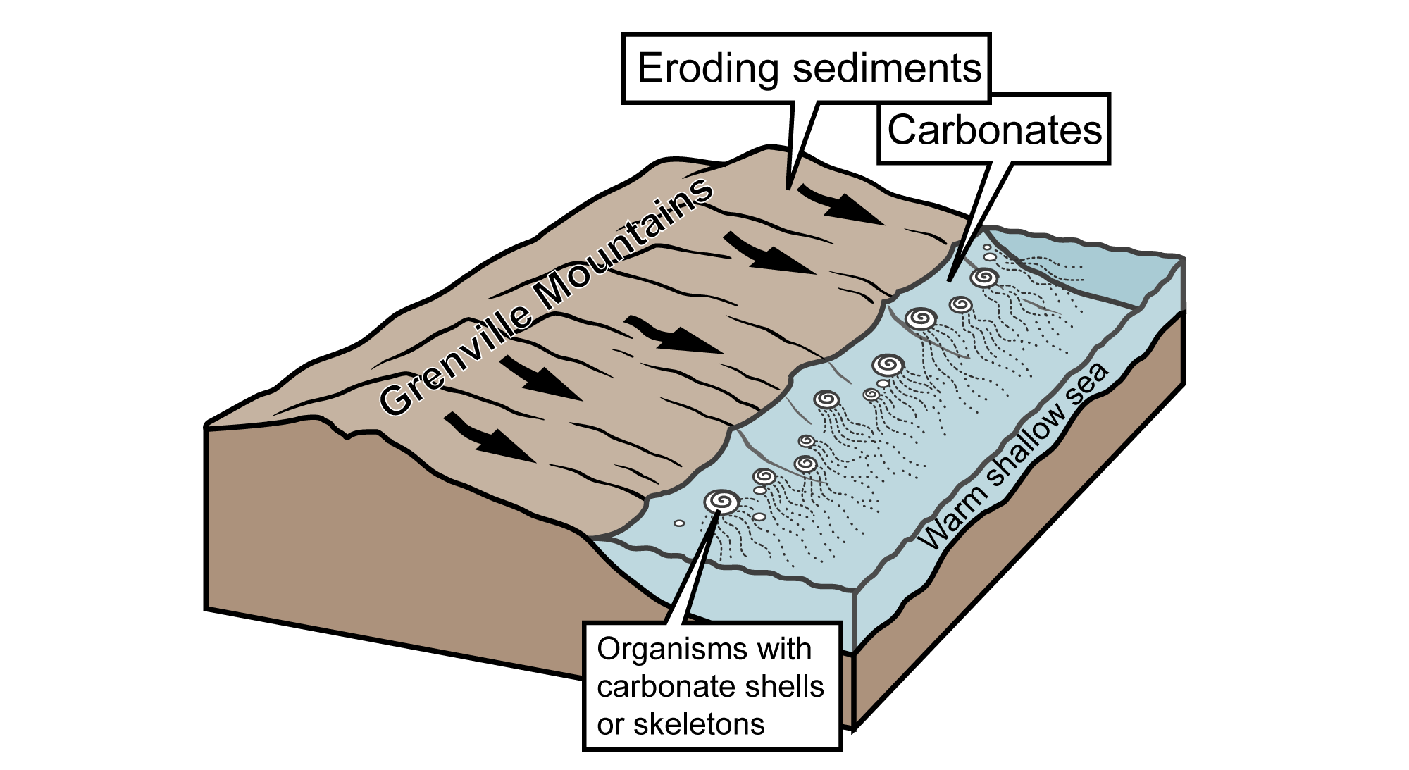
As the Grenville Mountains gradually eroded over millions of years, sediments were deposited on either side of the range and become interlayered with carbonate rocks that formed in shallow parts of shallow inland seas, as well as along North America's passive continental margin. Image modified from original by J. Houghton, first published in The Teacher-Friendly Guide to the Earth Science of the Southeastern US, 2nd ed., edited by Andrielle N. Swaby, Mark D. Lucas, and Robert M. Ross (published by the Paleontological Research Institution) (CC BY-NC-SA 4.0 license).
Cambrian and Ordovician (541 to 444 million years ago)
The Taconic Mountains
Around 500 million years ago, the Iapetus Ocean stopped widening and the continents began to move back toward each other. A subduction zone formed in the ocean floor. A subduction zone is a place where one tectonic plate moves under another tectonic plate. When two oceanic plates press together, friction between them generates enough heat and pressure to melt some of the crust. The molten rock rises through the crust and creates volcanoes along the edge of the overlying plate. The volcanoes frequently form in curved lines, and are therefore called island arcs. The Aleutian Islands, Philippine Islands, and Lesser Antilles are all modern examples of volcanic island arcs associated with subduction.
The Taconic volcanic island arc formed near a subduction zone between plates in the Iapetus Ocean. It apparently formed on or very close to one or more small pieces of continental crust.
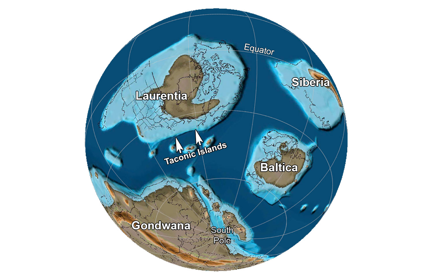
Earth 485 million years ago, at the beginning of the Ordovician Period. Laurentia is the name given to "proto-North America"; Baltica consists of modern northern European countries. Reconstruction created using basemap from the PALEOMAP PaleoAtlas for GPlates and the PaleoData Plotter Program, PALEOMAP Project by C. R. Scotese (2016); map annotations by Jonathan R. Hendricks for PRI's Earth@Home project (CC BY-NC-SA 4.0 license).
As the Iapetus Ocean continued to narrow, the Taconic island arc eventually collided with the margin of Laurentia, accreting to (essentially, adhering to) the continent. As continent and islands collided, the margin of the plate bearing Laurentia—which consisted of oceanic crust—was subducted beneath the plate bearing the Taconic island arc. This collision is recorded by a series of rocks called ophiolites. These rocks, which include deep-sea sediments overlying the crust, the oceanic crust itself, and rock from the upper mantle, were scraped off the descending edge of the Laurentian plate and added to the Laurentian continental crust.
As the collisions between the Taconic Island Arc and Laurentia continued, they caused the Taconic Orogeny, an episode of mountain building between around 490 and 460 million years ago. The pressure of these collisions was so great that large slabs of crust broke free and were pushed up and over the edge of the continent in a process called thrust faulting. This combination of folding, thrusting, uplift, and intrusion occurred along the entire margin of Laurentia.
The compression caused by the collisions also depressed (downwarped) the crust to the west of the Taconic Mountains, creating the Appalachian Basin. This basin, actually a connected set of basins that stretched from New York to Tennessee, formed in stages between the Ordovician and Carboniferous. It was flooded by a broad, shallow inland sea and filled with sediment eroded from the Taconic Mountains. Other inland basins also formed from the compressional forces of Taconic mountain building, including the Black Warrior Basin of northwest Alabama and northeast Mississippi.
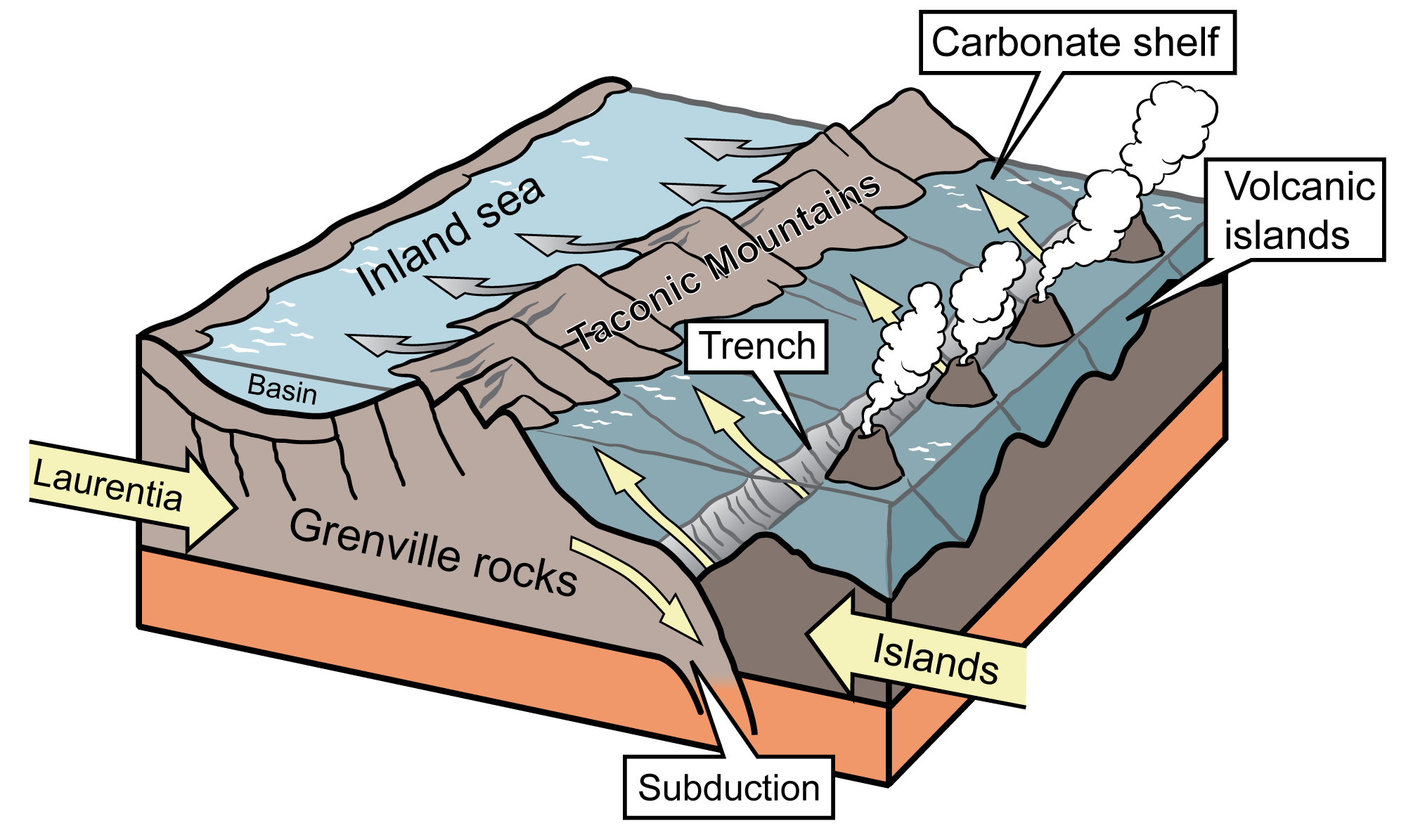
Volcanic islands formed where the plates were forced together as the Iapetus Ocean closed. The compression crumpled the crust to form the Taconic Mountains and a shallow inland sea farther to the west. Image modified from original by J. Houghton first published in The Teacher-Friendly Guide to the Earth Science of the Southeastern US, 2nd ed., edited by Andrielle N. Swaby, Mark D. Lucas, and Robert M. Ross (published by the Paleontological Research Institution) (CC BY-NC-SA 4.0 license).
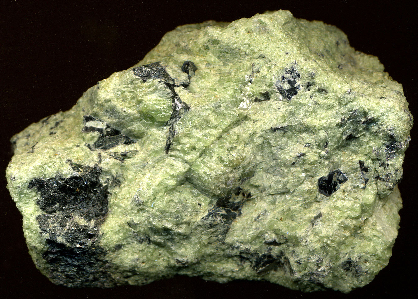
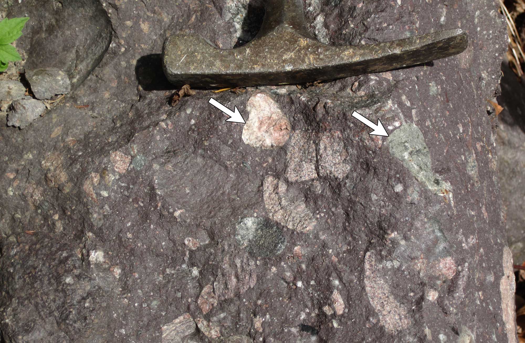
Day Book Dunite, Yancey County, North Carolina. Dunite is a type rock that can be found in ophiolite. The Day Book Dunite may be part of the ophiolite that accreted to Laurentia during the Taconic Orogeny. Information from and photo by James St. John (flickr, Creative Commons Attribution 2.0 Generic license).
Large chunks of rock like the Taconic Islands, which originate in one place and are eventually added to a continent, are called terranes (or sometimes "exotic" terranes to emphasize their distant origin). Addition (or accretion) of terranes is one of the major ways in which continents grow in size, as the terranes are pressed against the edge of the continent in a process sometimes known as "docking." After accretion, the boundaries between adjacent terranes are marked by major faults or fault zones. In the Southeast, the Taconic islands that collided with Laurentia are today part of the Piedmont terranes. In New England, they are called the Taconic Mountains.
The Taconic Orogeny ended by the late Ordovician. One more important tectonic event occurred in the late Ordovician. Rocks of the Carolina Terrane (Carolinia) were accreted to the southern margin of the Laurasian landmass (in today's terms, the eastern margin of North America, in the region of in the southern and central Appalachians). This happened perhaps as early as 455 million years ago. Carolinia had broken off of Gondwana, a large continent made up of land from present-day Africa, South America, India, Australia, Antarctica, and Florida . Two pieces of the Carolina Terrane—the Talladega Slate Belt and the Carolina Slate Belt—are noteworthy for containing fossils that indicate their origins far from North America.
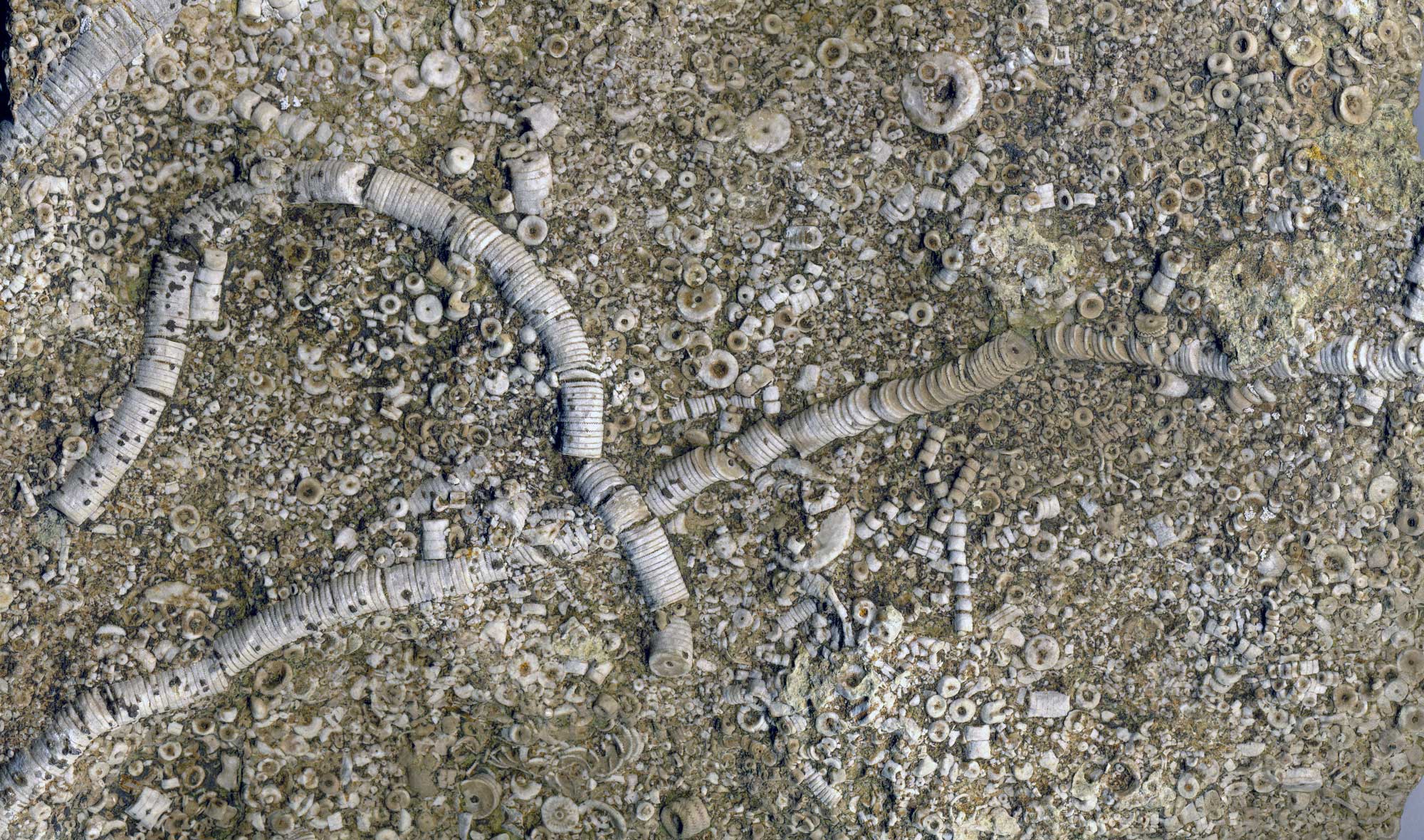
Outcrops and fossils thought to be from the region where Carolinia collided with Laurentia in the Paleozoic. Left: Outcrops in which late Ordovician to early Silurian tabulate corals were found in South Carolina. Right: Two fossil tabulate corals, late Ordovician to early Silurian, South Carolina. Figures 3a, 4a, and 4b from Landmeyer et al. (2019) PLoS ONE 14(10): e0224248 (Creative Commons CC0 1.0 Universal license, public domain dedication).
For many millions of years afterward, the Southeast experienced a quiet time during which erosion of sediments from the Taconic highlands and deposition of sediments in the inland sea were the main geological events. As sediment weathered from the western side of the Taconic Mountains, deltas spread along the shoreline. Deltas are wedge-shaped deposits formed when eroded sediment is transported from mountains, fanning out across lower elevations. Most of this sediment eroded from the western side of the Taconic Mountains was concentrated to the north, extending southward only as far as West Virginia and Virginia. Huge thicknesses of sedimentary rocks accumulated in and on the margins of the inland sea (the sea inland to the Taconic Mountains) in the Silurian.
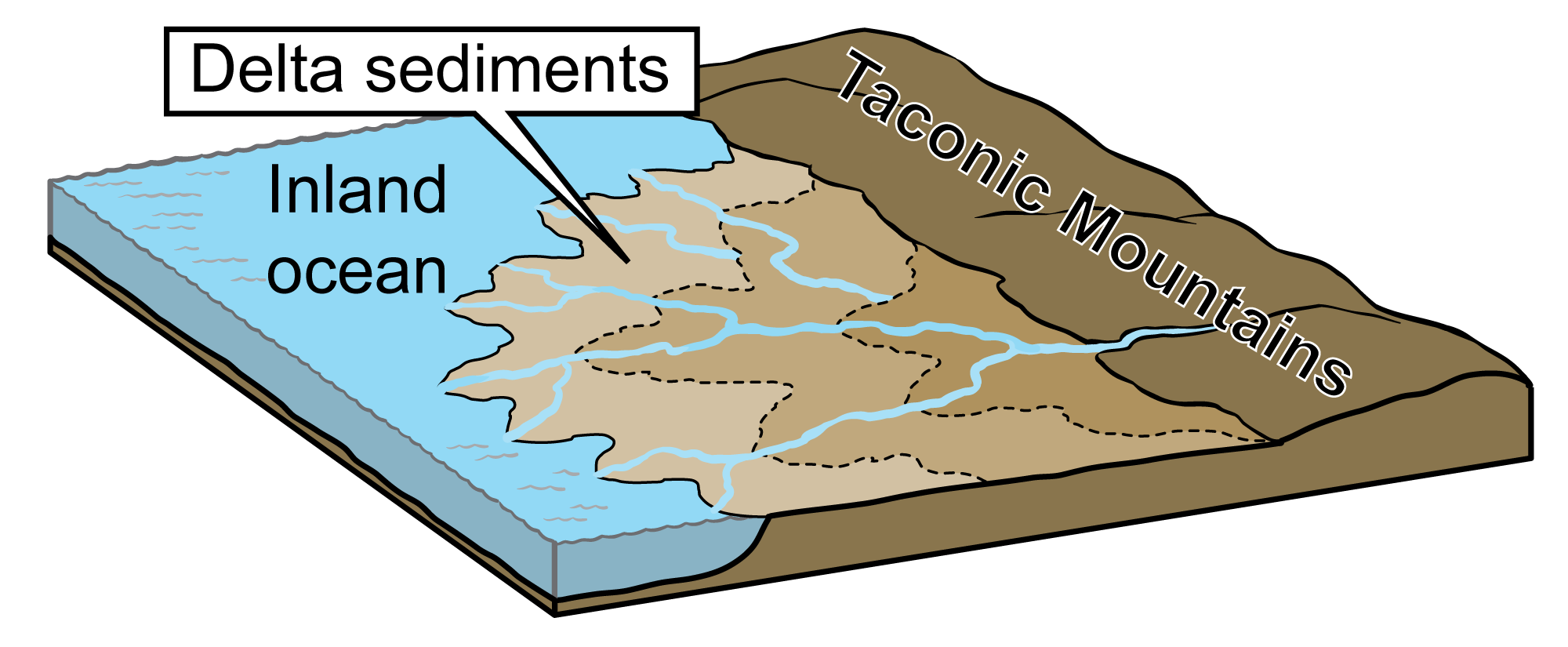
Delta deposits formed along the eroding Taconic Mountains into the inland sea. Image modified from original by J. Houghton first published in The Teacher-Friendly Guide to the Earth Science of the Southeastern US, 2nd ed., edited by Andrielle N. Swaby, Mark D. Lucas, and Robert M. Ross (published by the Paleontological Research Institution) (CC BY-NC-SA 4.0 license).
Silurian to Mississippian (444 to 323 million years ago)
The Acadian Mountains
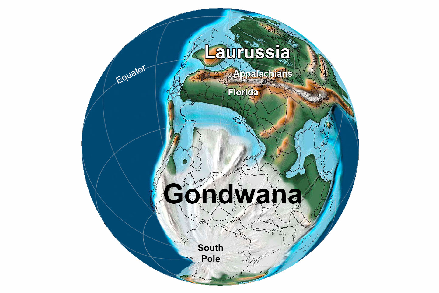
Beginning around 430 million years ago (in the mid-Silurian) and ending around 345 million years ago (in the early Mississippian), another series of continental collisions took place along Laurentia’s margin, resulting in the Acadian Orogeny. At the time of the Acadian Orogeny, the Southeast was located south of the equator. Africa, South America, India, Australia, Antarctica, and Florida were combined into the southern supercontinent of Gondwana. Most or all of the world's continental landmasses were gradually moving closer together. During this time interval, Laurentia also moved gradually closer to the present geographic position of North America.
The Acadian Orogeny involved several landmasses. In the north, Baltica (proto-Europe) collided with the eastern part of Laurentia (modern-day Greenland), creating the combined continent of Laurussia. Collisions further south on the margin of Laurentia involved two terranes that had broken off of Gondwana, the Avalon Terrane (Avalonia) and the Gander Terrane (Ganderia). Today, the Avalon and Gander terranes occur in the northern Appalachians, in the region of the northeastern United States and eastern Canada. To make the story even more complicated, these Gondwanan terranes were themselves the result of collisions among multiple smaller terranes. As with the Taconic Orogeny, the collisions that were part of the Acadian Orogeny squeezed, folded, and metamorphosed the rocks of Laurentia's eastern margin. Magma also intruded these rocks.
By the Mississippian period, the Inland Basin was still flooded with a warm inland sea in which abundant limestone was deposited.
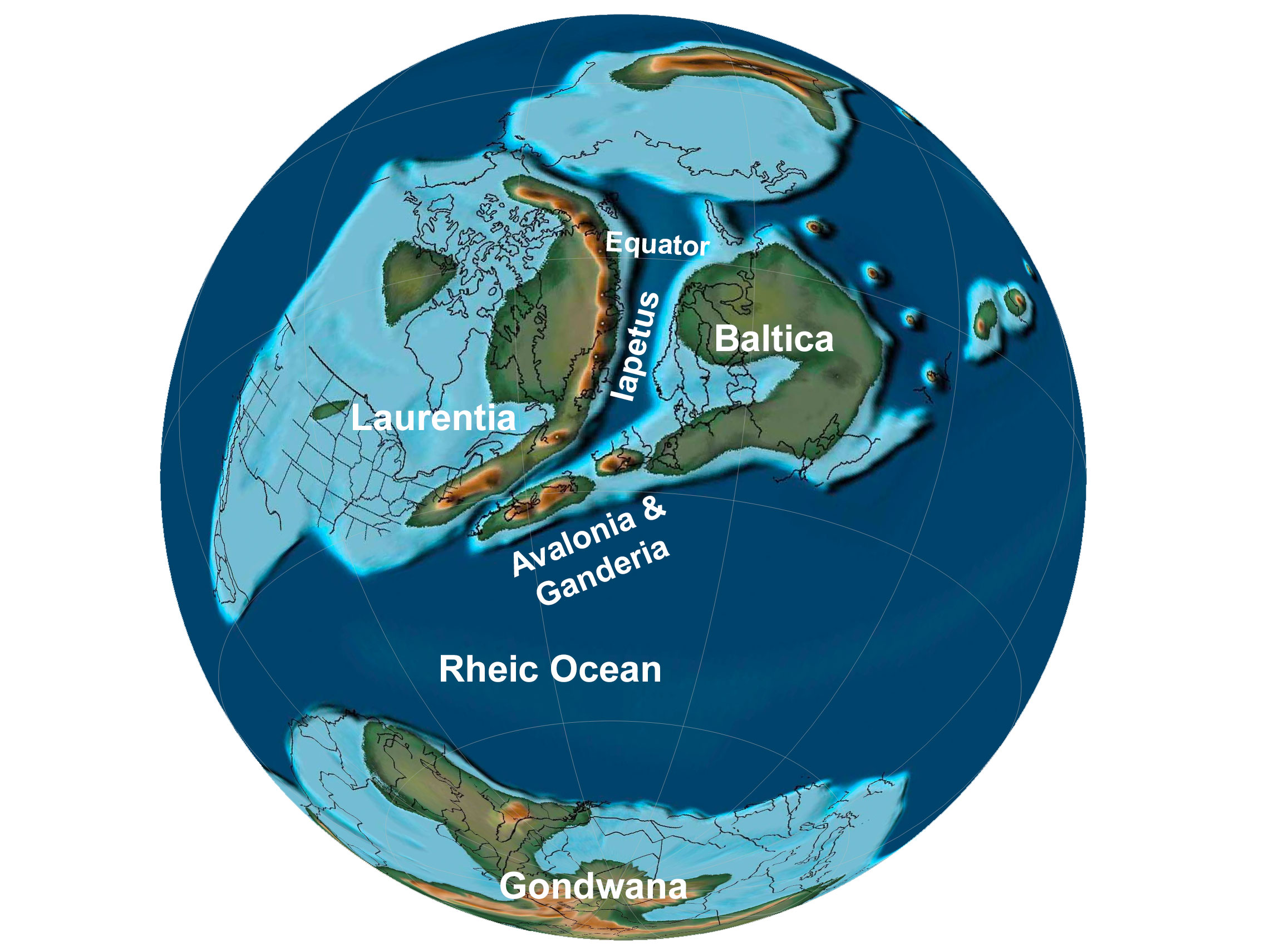
Earth 430 million years ago, during the middle of the Silurian period. The Iapetus Ocean was closing as Baltica, Avalonia, and Ganderia neared the margin of Laurentia . Reconstruction created using basemap from the PALEOMAP PaleoAtlas for GPlates and the PaleoData Plotter Program, PALEOMAP Project by C. R. Scotese (2016); map annotations by Elizabeth J. Hermsen for PRI's Earth@Home project (CC BY-NC-SA 4.0 license).
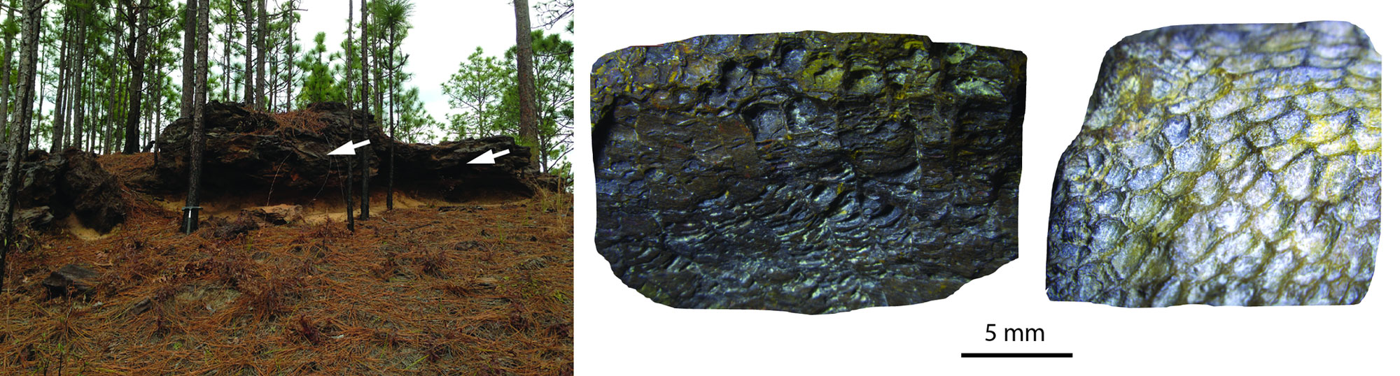
Crinoid stems and stem segments preserved in limestone from the lower Mississippian Fort Payne Formation, Lake Cumberland, south-central Kentucky. Width of image is about 23 cm (9.1 in). Information from and photo by James St. John (flickr, Creative Commons Attribution 2.0 Generic license, image resized).
Pennsylvanian to Permian (323 to 252 million years ago)
Pangaea and the Appalachians
Approximately 300 to 250 million years ago, through the Pennsylvanian and Permian periods, a final mountain-building event occurred as Gondwana collided with North America to form the supercontinent Pangaea. This mountain-building event is known as the Alleghanian Orogeny. The Alleghanian closed the Rhetic Ocean that separated Laurussia (the combined Laurentia-Baltic continent) from Gondwana. It is responsible for the basic structure of the Appalachian Mountains, creating the central and southern Appalachians. The resulting Appalachian Mountain chain extends from Alabama to Canada. At their highest, the Appalachian Mountains may have been as tall and rugged as the Himalayan Mountains of Asia are today.
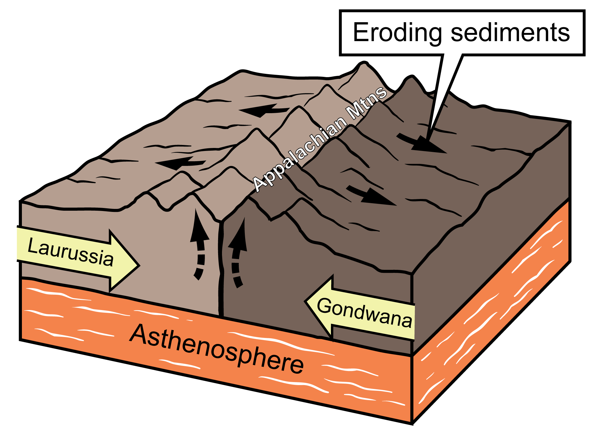
Diagram showing the collision between the margins of the Laurussian and Gondwanan continents that formed the Appalachian Mountains. Image modified from original by J. Houghton first published in The Teacher-Friendly Guide to the Earth Science of the Southeastern US, 2nd ed., edited by Andrielle N. Swaby, Mark D. Lucas, and Robert M. Ross (published by the Paleontological Research Institution) (CC BY-NC-SA 4.0 license).
The Alleghanian Orogeny caused the rocks along what is presently the eastern margin North America to compress. Slices of crust were thrust toward the interior of the continent along enormous faults such as the Brevard Fault Zone, which runs along the eastern edge of the Blue Ridge from Alabama to the North Carolina-Virginia border today. The Alleghanian Orogeny caused the crust of the affected region of Laurussia (present-day eastern North America) to shorten by almost 200 kilometers (120 miles). The orogeny also metamorphosed sediment deposited in the inland ocean earlier in the Paleozoic era as well as the rocks from the Taconic and Acadian orogenies that had been added to the margin of Laurentia in earlier time periods.
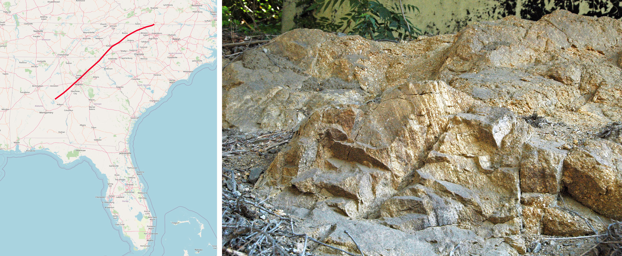
Brevard Fault Zone. Left: Map showing the location of the Brevard Fault Zone (red line). Map by SMotz3 (Wikimedia Commons, Creative Commons Attribution-Share Alike 4.0 International license, image cropped). Right: Paleozoic rocks in the Brevard Fault Zone that were deformed by tectonic activity associated with the Alleghanian Orogeny. Information from and photo by James St. John (flickr, Creative Commons Attribution 2.0 Generic license, image cropped and resized).
The South American portion of Gondwana also collided with the North America portion of Laurussia during the early Pennsylvanian, forming the Ouachita Mountains of Arkansas and Texas. These mountains originally extended into Mississippi, but are now buried beneath younger sediments in that region.
The geological basement of the modern Florida peninsula was the last major piece of present-day North America to be attached to the eastern portion of the continent. This basement is composed of two major pieces: the Florida-Bahama Block and the Suwannee Basin Block (also known as the Tallahassee-Suwanee Terrane). Both of these pieces were part of Gondwana when it collided with Laurussia in the late Paleozoic. These blocks are recognizable today as different from the rest of the continent due to the distinctive rocks and fossils they contain. We know about Florida’s ancient basement only from drill cores and other remote geophysical methods, as no surface rock in Florida is older than the Cenozoic.
Earth 300 million years ago, during the end of the Carboniferous Period (Pennsylvanian). Pangaea was completed when North America finally collided with Gondwana. Reconstruction created using basemap from the PALEOMAP PaleoAtlas for GPlates and the PaleoData Plotter Program, PALEOMAP Project by C. R. Scotese (2016); map annotations by Jonathan R. Hendricks & Elizabeth J. Hermsen for PRI's Earth@Home project (CC BY-NC-SA 4.0 license).
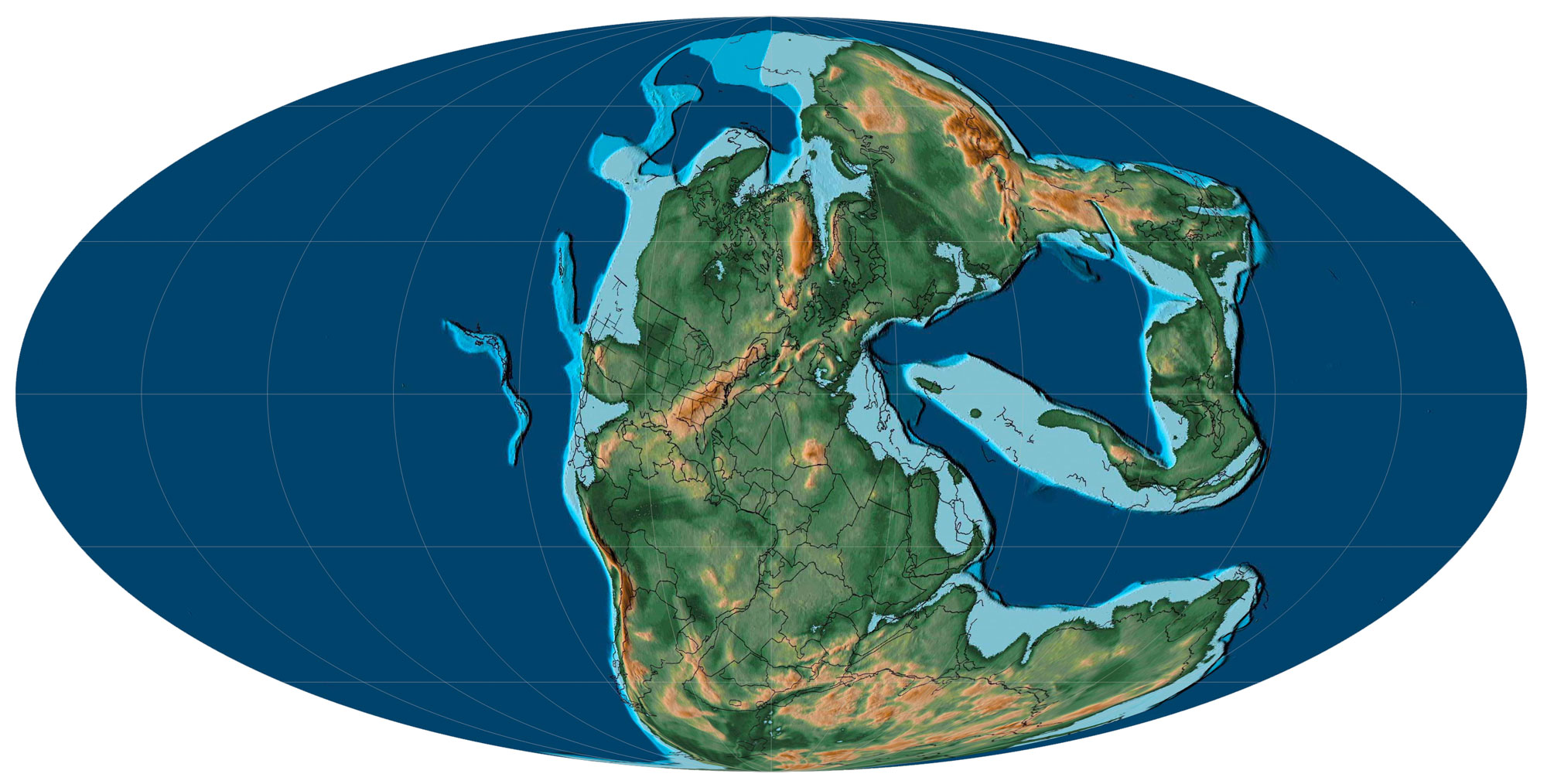
Earth 250 million years ago, near the Permian-Triassic boundary, showing Pangaea. In this Molleweide projection, most of the supercontinent can be seen. Reconstruction created using basemap from the PALEOMAP PaleoAtlas for GPlates and the PaleoData Plotter Program, PALEOMAP Project by C. R. Scotese (2016).
During the Pennsylvanian to Permian, sea levels began to fluctuate and ultimately fall. Regression of the sea was caused by a combination of glaciation at the South Pole and the forces of mountain building. Along the margins of the retreating sea, enormous coastal swamps formed. These swamps extended from modern Pennsylvania to Alabama and were dominated by strange trees related to modern clubmosses and horsetails. When the vegetation in these swamps died, it fell into stagnant, oxygen-poor water. The lack of oxygen in the water slowed decomposition, forming huge deposits of peat. Sediment covered these deposits, compressing and ultimately metamorphosing them into some of the largest coal beds in the world. The extensive coal beds in North America and western Europe give the Carboniferous period its name.
The burial of so much carbon lowered the amount of carbon dioxide (CO2) in the Earth's atmosphere, and the abundant plant life raised global oxygen levels. Global temperatures continued to fall, accelerating glaciation in the southern hemisphere and lowering sea level worldwide. Ultimately, the sea retreated completely from the Interior Basin (in modern times, the ancient basin located to the west of the Appalachian Mountains), which is why there is no marine sediment younger than Pennsylvanian in age across this area of North America.
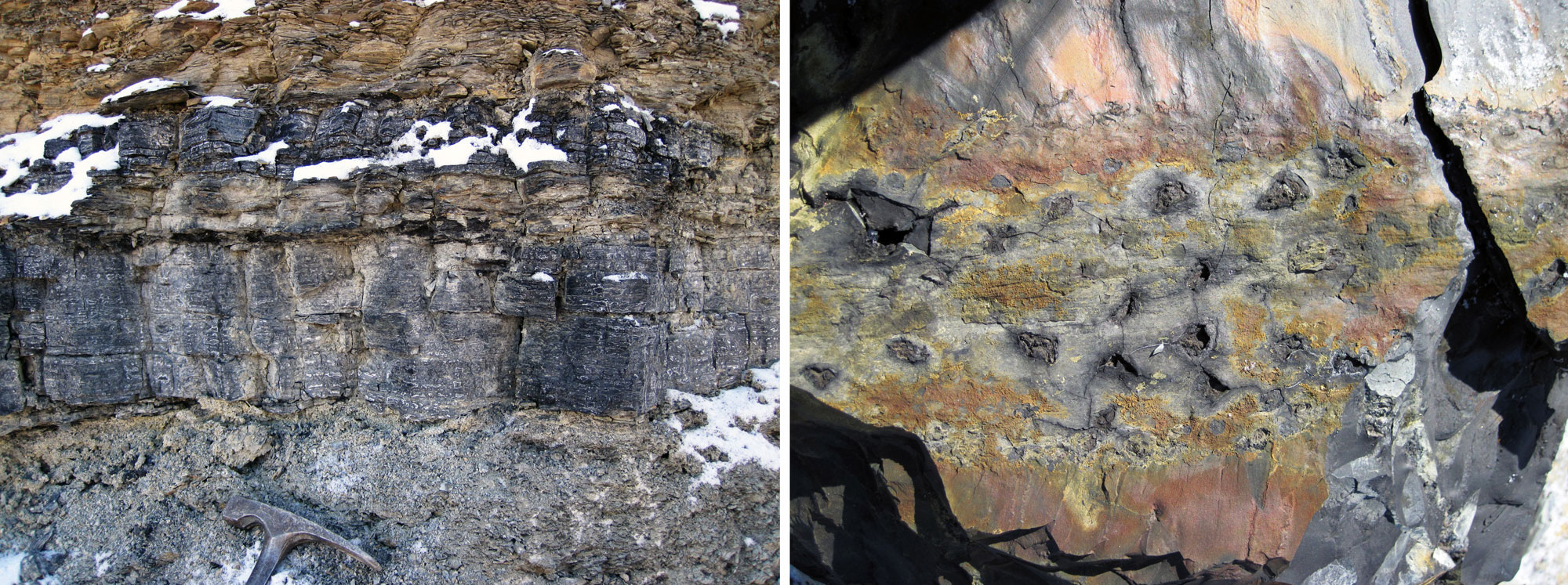
Bituminous coal deposits, middle Pennsylvanian Pikeville Formation, Breathitt County, Kentucky. Left: Thick coal layers. Information from and photo by James St. John (flickr, Creative Commons Attribution 2.0 Generic license, image cropped and resized). Right: Remains of Stigmaria, an organ that anchored Pennsylvanian-aged trees related to modern clubmosses. The pits in the coal are the sites of rootlets that were attached to a larger, branching rootlike structure known as a rhizomorph. Information from and photo by James St. John (flickr, Creative Commons Attribution 2.0 Generic license, image cropped and resized).
Triassic to Jurassic (252 to 145 million years ago)
Breakup of Pangaea
The supercontinent Pangaea lasted less than 100 million years before Earth’s dynamic crust began to break it apart. Rifts developed in the middle of the supercontinent. These rifts occurred along a series of cracks in the Earth's crust roughly parallel to the present eastern coastline of North America.
As rifts developed, blocks of crust slid down faults on the rift margins to form rift basins bounded by tall cliffs. Sediments accumulated in the rift basins, forming flat-lying sandstone and shale layers that alternated with ash deposits and lava flows produced by volcanoes in the rift zone. Eventually, the horizontal layers of rock in the rift basins faulted and tilted, exposing the edges of the sedimentary rock and cooled lava. In the eastern United States, the late Triassic and early Jurassic rocks that formed when Pangaea began to break apart are collectively called the Newark Supergroup. In the Southeast, the Newark Supergroup is exposed at the surface in Virginia and North Carolina.
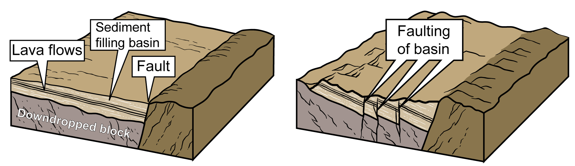
The formation of rift basins in the southeaster U.S. during the Mesozoic Era. Left: As rifting occurred, blocks of crust slid down faults to form a basin, which filled with sediment and lava flows. Right: Eventually, the entire basin was tilted and faulted. Images modified from original by J. Houghton, first published in The Teacher-Friendly Guide to the Earth Science of the Southeastern US, 2nd ed., edited by Andrielle N. Swaby, Mark D. Lucas, and Robert M. Ross (published by the Paleontological Research Institution) (CC BY-NC-SA 4.0 license).
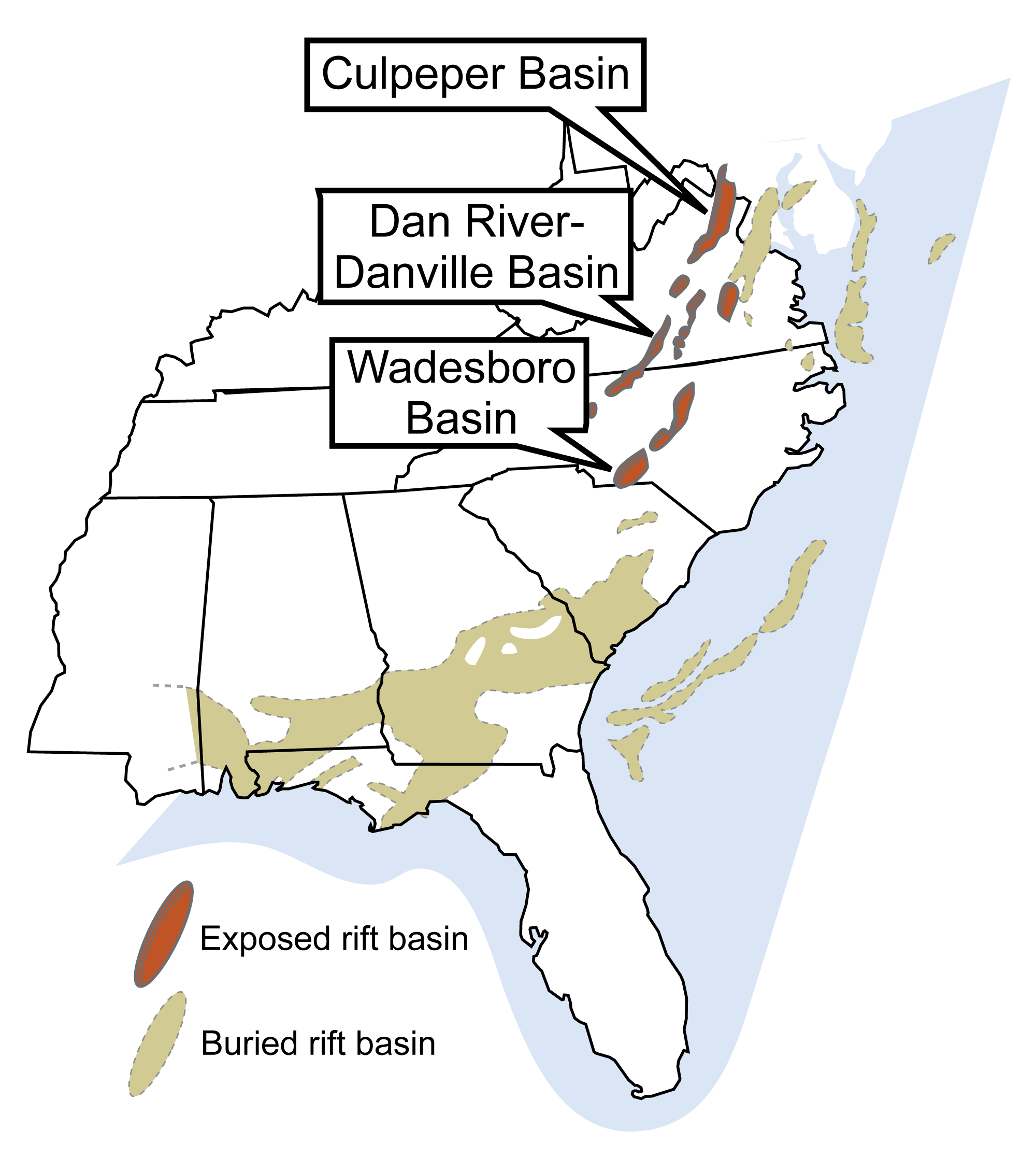
The Triassic and Jurassic rift basins of the Southeastern U.S. formed as eastern North America separated from Gondwana. Many basins are buried by younger sediment and are located on the continental shelf as well as on land. Image modified from original by Jim Houghton, first published in The Teacher-Friendly Guide to the Earth Science of the Southeastern US, 2nd ed., edited by Andrielle N. Swaby, Mark D. Lucas, and Robert M. Ross (published by the Paleontological Research Institution) (CC BY-NC-SA 4.0 license).
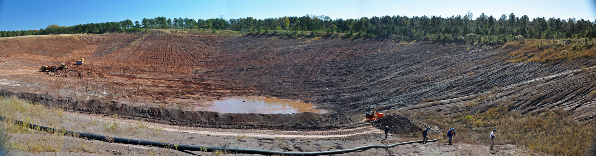
Upper Triassic rocks of the Newark Supergroup exposed in a quarry in North Carolina. Information from and photo by James St. John (flickr, Creative Commons Attribution 2.0 Generic license, image resized).
During the Jurassic, the final break between Laurasia (North America, Europe, and western Asia) and West Gondwana (South America and Africa) occurred, opening the Gulf of Mexico and the Central Atlantic Ocean.
The Central Atlantic Ocean began to widen as northwestern Africa separated from North America along what is now part of the Mid-Atlantic Ridge. (Note: The Central Atlantic as discussed here is considered part of the North Atlantic today.) As continental rifting transitioned into seafloor spreading, the east coast of North America no longer experienced the strong tectonic activity associated with the rifting of the plate margin. Eastern North America became a passive margin.
The Gulf of Mexico opened up as South America and North America separated. In the early stages of its formation, the Gulf of Mexico was the site of abundant salt formation, as seawater from the first shallow arms of the ocean evaporated. Eventually, this Jurassic salt was deeply buried beneath sediments carried into the Gulf by rivers. These salt deposits would later become important in trapping petroleum and natural gas beneath the modern Gulf.
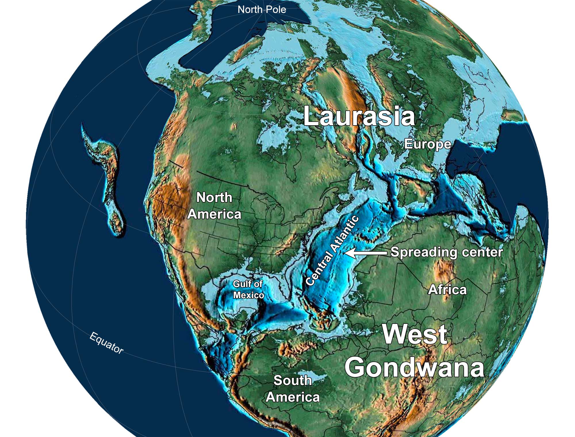
Earth 150 million years ago, near the end of the Jurassic Period. North America and Europe are part of Laurasia, and South America and Africa are part of Gondwana. Notice that North America has separated from Africa and there is a spreading center in the Central Atlantic Ocean. Reconstruction created using Paleomap (by C. Scotese) for GPlates. Reconstruction created using basemap from the PALEOMAP PaleoAtlas for GPlates and the PaleoData Plotter Program, PALEOMAP Project by C. R. Scotese (2016); map annotations by Jonathan R. Hendricks and Elizabeth J. Hermsen for PRI's Earth@Home project (CC BY-NC-SA 4.0 license).
Cretaceous to Neogene (145 to 2.6 million years ago)
Building the Coastal Plain
The Late Cretaceous period was marked by very high sea levels worldwide, in part due to the significant increase in plate tectonic activity that accompanied the breakup of Pangaea. When the continents began to move apart, continental rifts eventually transformed into oceanic crust. The seafloors spread, or widened, as the continents continued to move apart and new oceanic crust formed from magma that rose up through deep-sea ridges like the Mid-Atlantic Ridge. The displacement of ocean water due to heightened activity at these ridges during the Cretaceous contributed to a higher global sea level. Seafloor spreading eventually slowed and activity at the ridges subsided, allowing sea level to fall.
While the South and Central Atlantic oceans had opened by the end of the Cretaceous, the present-day northern hemisphere continents of North America and Eurasia (minus the Indian subcontinent) were still connected over the North Atlantic, forming the continent of Laurasia. North America and Europe would not truly separate until the Eocene, when a spreading center formed and opened the North Atlantic between Greenland and Europe.
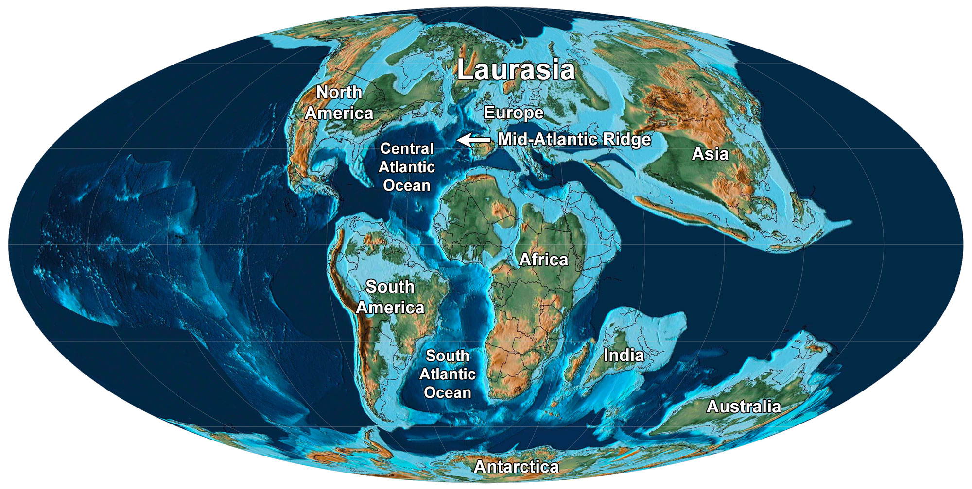
Earth 80 million years ago, during the Late Cretaceous Period, Molleweide projection. North America and Eurasia make up Laurasia, whereas the Gondwana continents have begun to drift apart. Reconstruction created using Paleomap (by C. Scotese) for GPlates. Reconstruction created using basemap from the PALEOMAP PaleoAtlas for GPlates and the PaleoData Plotter Program, PALEOMAP Project by C. R. Scotese (2016); map annotations by Elizabeth J. Hermsen for PRI's Earth@Home project (CC BY-NC-SA 4.0 license).
During the Cretaceous, the Paleogene, and the Neogene, the eastern margin of North America was still a passive continental margin. Rivers and streams transported sediment from the mountains to the coast, forming successive layers that fanned out across the gently sloping continental shelf and built up the Atlantic and Gulf Coastal plains. The Fall Line, a break between the harder inland rock and the softer sediments deposited on the coast, marks the boundary between the Coastal Plain and the Blue Ridge and Piedmont region.
The rifting and breakup of Pangaea left an irregular continental margin on eastern North America. It was marked by higher promontories jutting eastward into the Atlantic and lower embayments filled with ocean water cutting into the continental margin. The embayments became sites of deposition for thick piles of eroded sediments. Each embayment has a separate stratigraphic sequence. Geologists build knowledge of geologic history in the Coastal Plain by connecting these sequences with each other, correlating the different sedimentary layers through the characteristics of the fossils in each one.
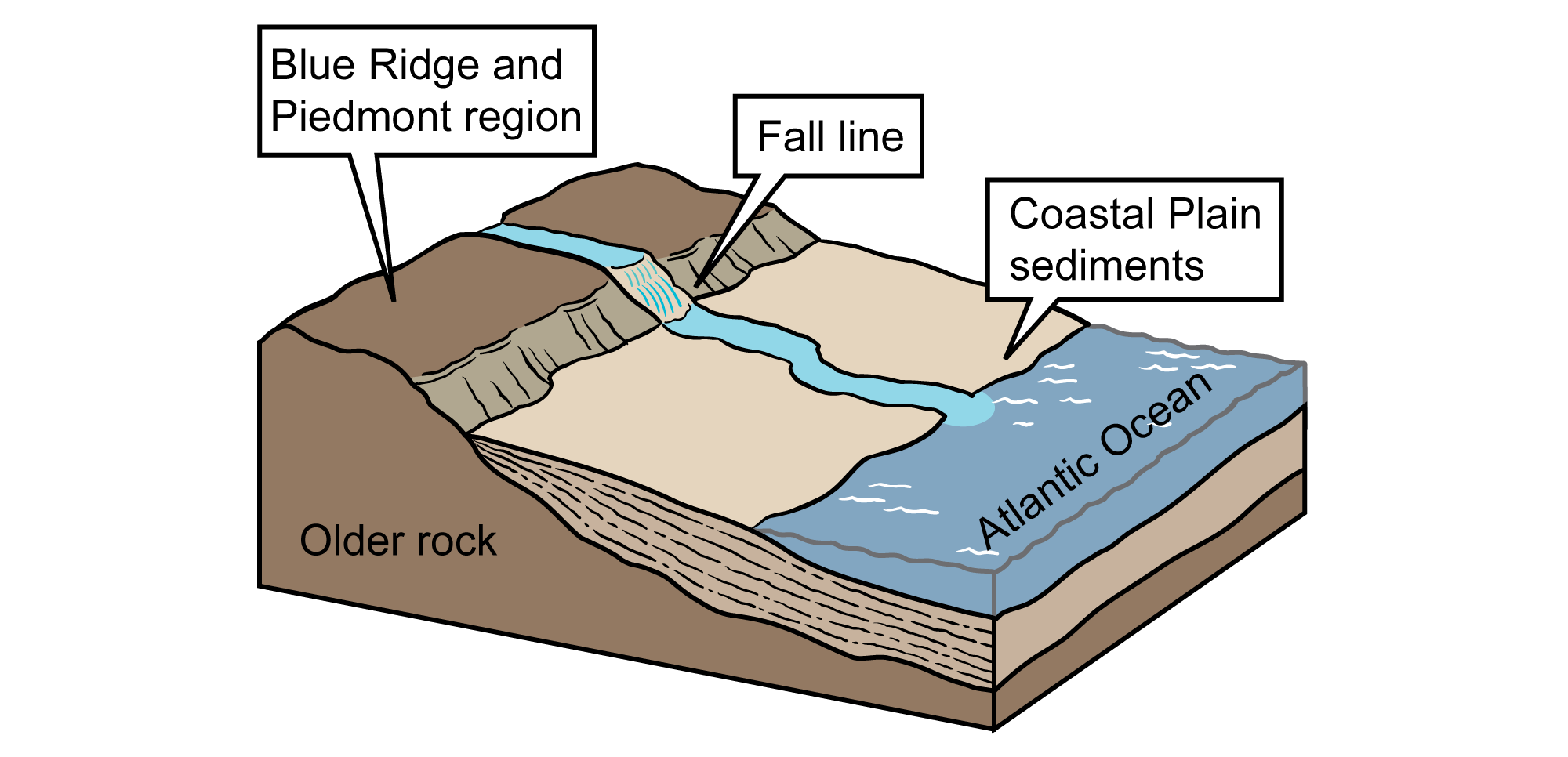
The Fall Line, between the Blue Ridge/Piedmont and Coastal Plain regions. Image modified from original by Jim Houghton, original for the Teacher-Friendly Guide to Earth Science series.
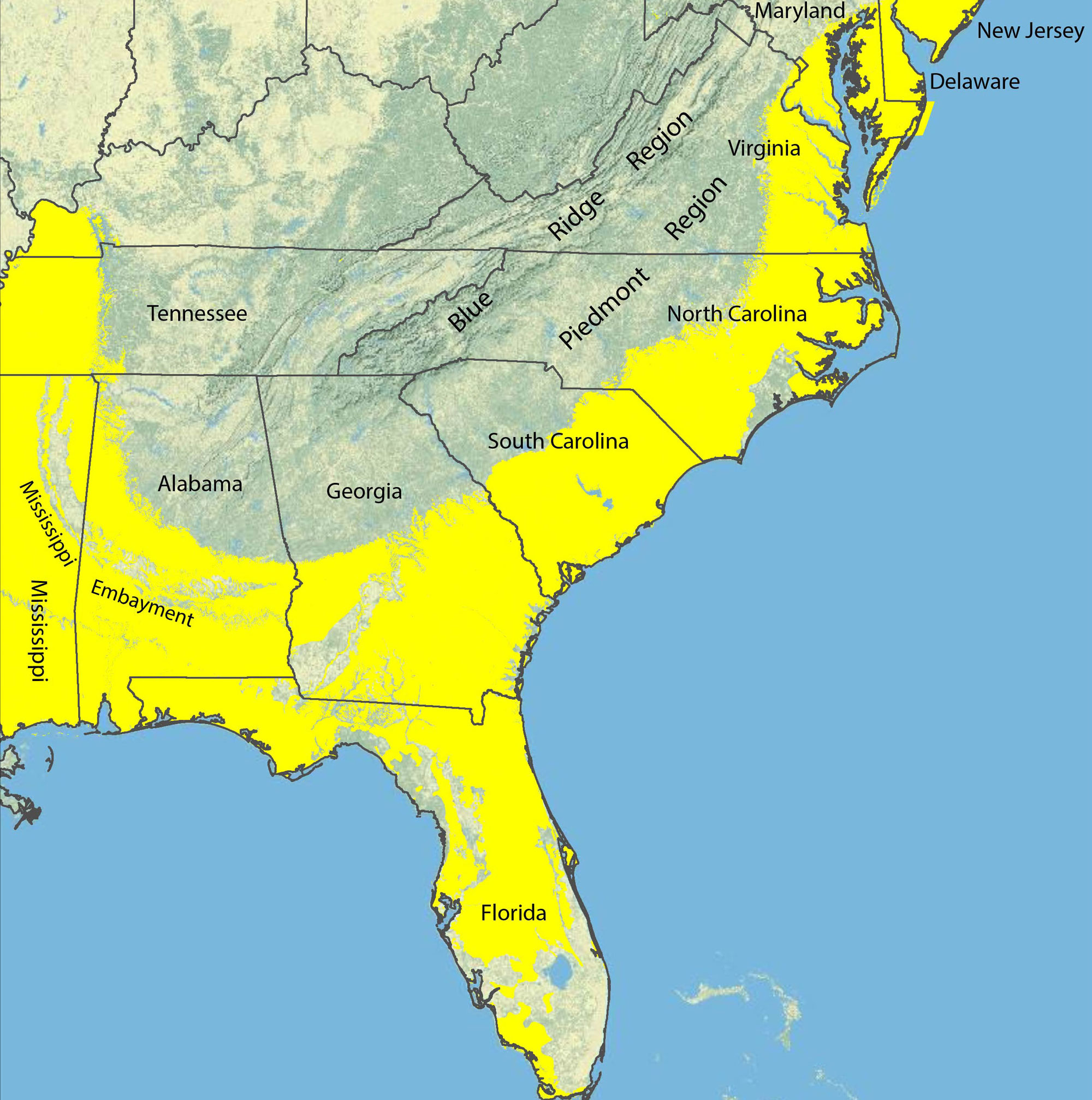
Map of the Coastal Plain in most of the southeastern US showing sedimentary deposits from the Late Cretaceous to Recent in yellow. The Fall Line roughly traces the the inland margin of these deposits. The Mississippi Embayment (discussed below) is on the left (western) side of the map. Map by the USGS (public domain).
Formation of the Mississippi Embayment
The Mississippi Embayment is a relatively low, flat area that separates the Appalachian and Ouachita mountain ranges today. It extends from the confluence of the Ohio and Mississippi Rivers in the north to the Gulf of Mexico in the south.
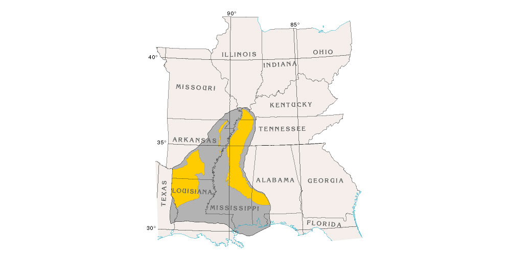
Beginning 95 million years ago, North America passed over a hot spot in the mantle. Magma rising beneath North America's continental crust uplifted a portion of the Ouachita-Appalachian Mountains, creating an arch. Since this arch was higher than the surrounding landscape, it was preferentially weathered.
After the continent passed over the hot spot, the crust making up the arch was significantly thinner due to erosion. As the crust making up the arch began to cool, it subsided and eventually formed a basin. The ocean flooded the area between the Interior Highlands—the highland region extending across Missouri, Arkansas, and Oklahoma—and the Appalachians, creating the Mississippi Embayment.

The Florida Platform
Florida's modern peninsula is the above-water portion of the much larger Florida Platform, a feature made mostly of accumulated limestone that is covered with a relatively thin layer of sand. The underwater Florida Escarpment is a drop-off that forms the edge of the Florida Platform, where water depth falls from about 90 m (300 ft) to 3000 m (10,000 ft).
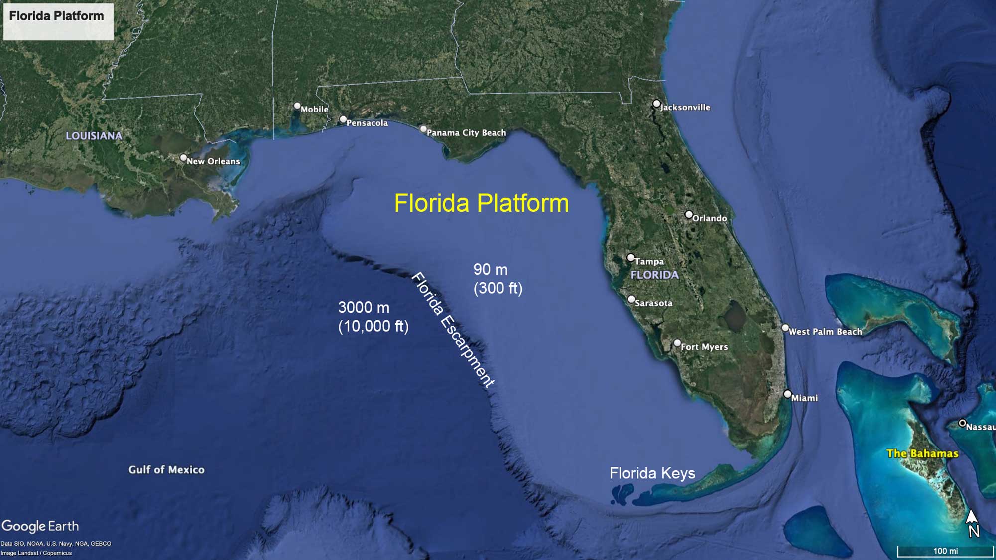
The extent of the Florida Platform and surrounding water depths. Map © Google Earth; labels added. Data from SIO, NOAA, U.S. Navy, NGA, GEBCO, Image Landsad / Copernicus.
The Florida Platform began forming as Pangaea broke up in the Mesozoic. One of the rift basins that developed between North America and Gondwana extended across the northern part of the Florida Platform, from what is now the northeastern corner of the Gulf of Mexico to the Atlantic coast of Georgia. This basin was called the Suwannee Channel.
From the Cretaceous to the Eocene, the Suwannee Channel separated the Appalachians from the growing carbonate bank of the Florida Platform to the south. The Suwannee Current that traveled through the channel from west to east diverted sediment that eroded from the Appalachians away from the Florida Platform and into the Atlantic Ocean. Thus, the Suwannee Current prevented sediment from covering Florida's developing carbonate bank, allowing a massive deposit of limestone to form.
In the mid-Eocene, the sediment-trapping function of the Suwannee Channel was taken over by the Gulf Trough, which was located slightly to the north. The Gulf Trough eventually filled, and sediment eroded from the Appalachians was no longer diverted away from Florida. Thus, the sediment began to accumulate on the Florida Platform.
Today, the main sites of carbonate deposition in the Southeast are the southern tip of Florida and in the Florida Keys, where reefs still grow thanks to warm temperatures and a low influx of siliciclastic sediment.
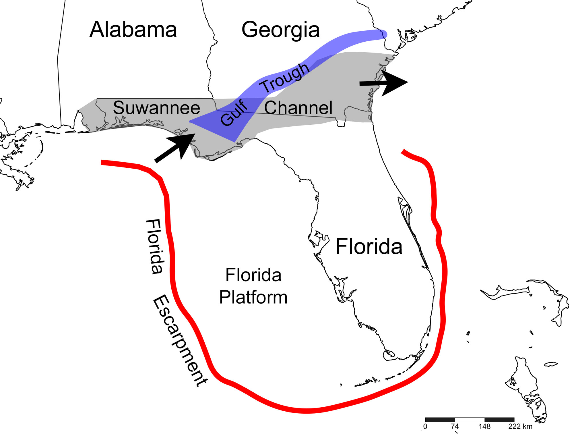
Map showing the approximate locations of the Suwannee Channel (Cretaceous to Eocene) and Gulf Trough (Eocene to Oligocene). The arrows indicate the approximate direction that the Suwannee Current would have flowed through the Suwannee Channel, diverting sediment away from the Florida Platform and toward the Atlantic. The red line shows the approximate extent of the Florida Escarpment. Map created by Elizabeth J. Hermsen for Earth@Home, based on fig. 1 in Williams and Kuniansky (2015) USGS Professional Paper 1807 and fig. 1 in Roberts-Ashby et al. (2015) USGS Open-File Report 2012-1024-L; base map from Simplemappr (Shorthouse 2010).
Quaternary (2.6 million years ago to present)
Mountains of Ice
The Quaternary period is divided into two epochs: the Pleistocene and Holocene. During the Pleistocene, ice sheets advanced south and retreated north several dozen times, reaching their last maximum extent 25,000–18,000 years ago. The Holocene epoch is the most recent (and current) period of retreat, and is referred to as an interglacial interval. The beginning of the Holocene is considered to be 11,700 years ago, or about 9700 BCE.
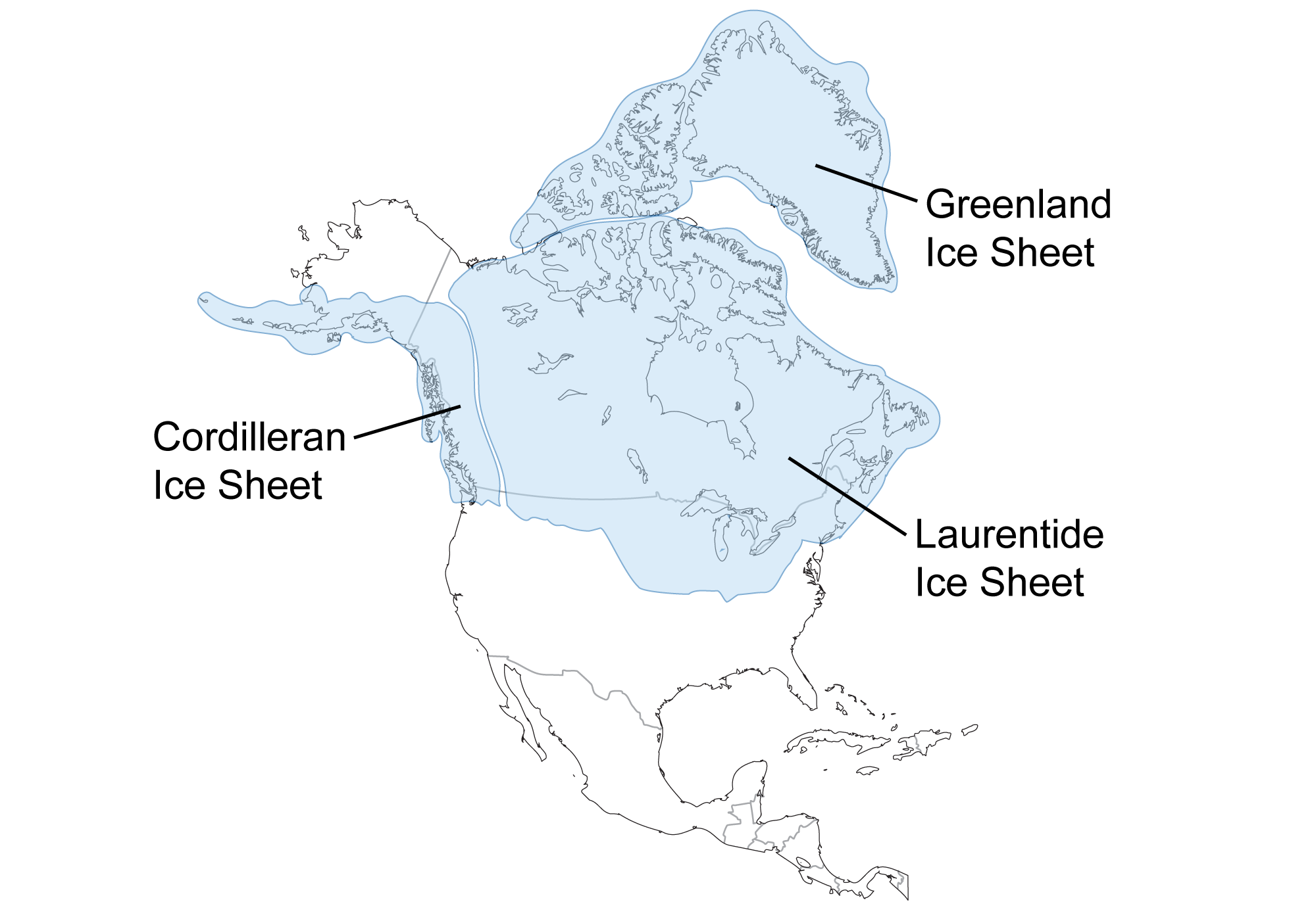
Extent of glaciation over North America during the last glacial maximum approximately 25,000 to 18,000 years ago. Image created by PRI staff for the Earth@Home project (CC BY-NC-SA 4.0 license).
The Pleistocene ice sheets did not extend into the Southeast. Here, the predominant effects of the ice age were the rise and fall of sea level, changes in drainage and deposition patterns, changes in weather, and changes in the distribution of plant and animal species. At the peak of the last glacial advance around 22,000 years ago, sea level was over 100 meters (330 feet) below its current level. Widely fluctuating sea levels drastically affected the erosion and deposition of sediment on the Coastal Plain, creating river terraces and steepening stream gradients that caused more rapid erosion of stream beds.
Fluctuating sea levels also created scarps (cliffs) where old shorelines once existed. Because sea level was lower during the glaciations of the Pleistocene than it is today, Pleistocene scarps are now submerged. However, older scarps from when sea level was higher can be seen today in some inland areas of the southeast. For example, scarps in the Carolinas represent higher coastlines that existed between 3 and 4 million years ago in the Neogene.
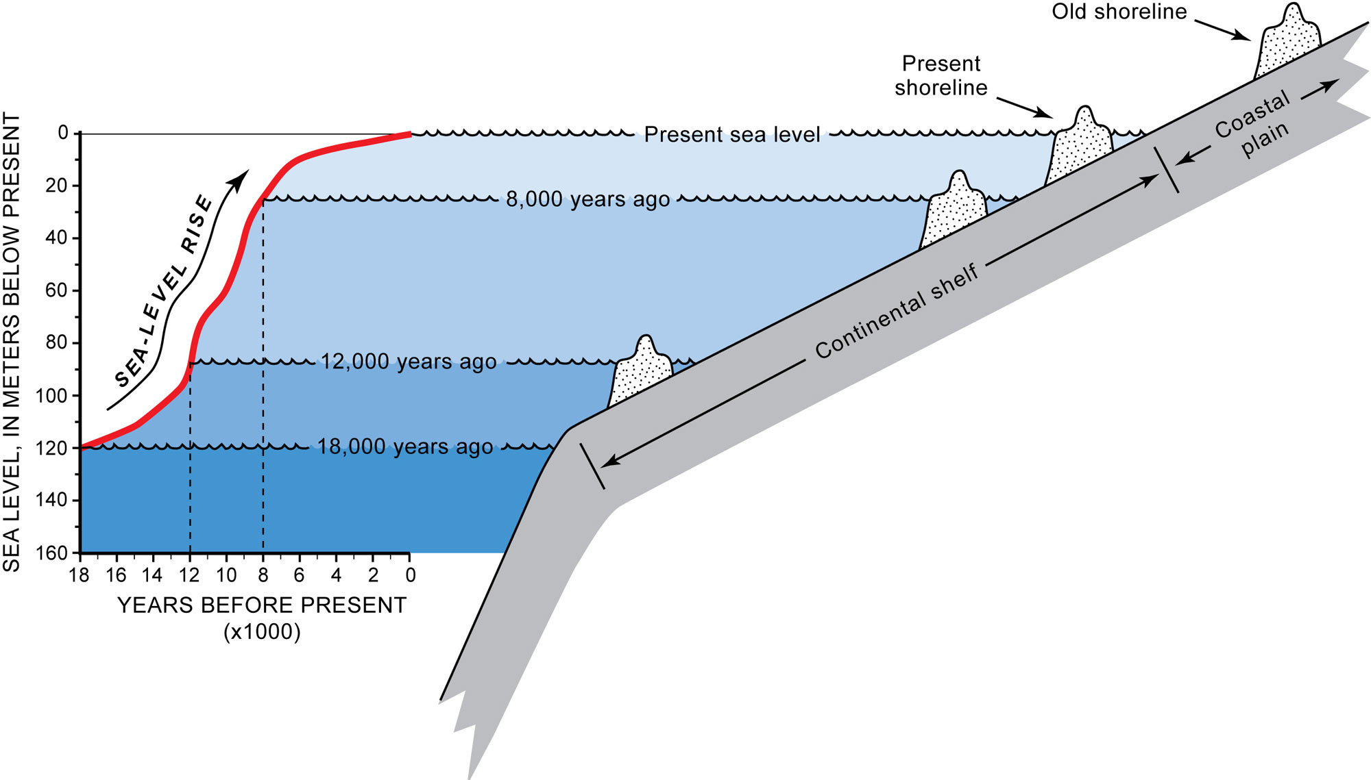
Sea level rise from about the Last Glacial Maximum and the recent. Note that at each ancient shoreline, a scarp forms. Because sea level was lower during Pleistocene glacial periods, the ancient coastlines from this time period are submerged. However, coastlines from times when sea level was higher than today, such as in the Neogene, can be found inland. Figure 1.5 from Schwab et al. (2009) USGS Open-File Report 2008-1206, caption adapted based on original.
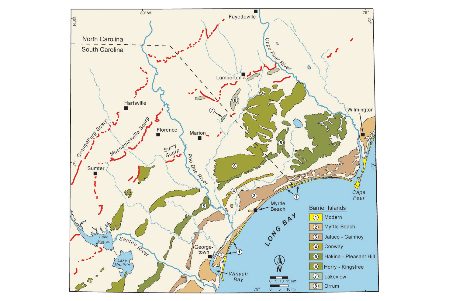
Scarps (red lines) representing Neogene coastlines dating from 4 to 3 million years old in the Carolinas. Figure 1.6 from Schwab et al. (2009) USGS Open-File Report 2008-1206, caption adapted based on original.
Of all the states in the Southeast, sea level changes most dramatically affected the shape and sedimentary deposits of Florida. When glaciation was at its maximum and sea levels were at their lowest during the Pleistocene, the above-water portion of the Florida peninsula was almost 480 kilometers (300 miles) across at its widest. Today, it is about 258 kilometers (160 miles) across.
The ice age continues today, but the ice sheets have retreated for now and Earth is in an interglacial stage. The current interglacial period has slowed both erosional and depositional processes in the Southeast. This, coupled with a higher, more stable sea level, has allowed coastal features such as barrier islands and lagoons to form, resulting in the landscape we know today. The pattern of glacial-interglacial cycling in the Quaternary indicates that the world will return to a glacial stage in the future unless the impacts of human-induced climate change radically shift these natural cycles.
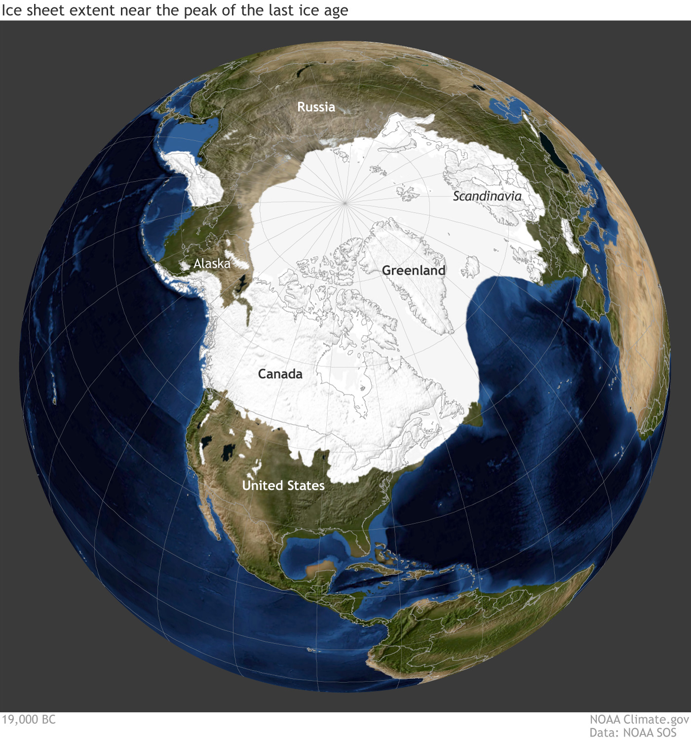
Earth during the last glacial maximum, around 20,000 years ago in the Pleistocene epoch. Much of North America was covered with a large sheet of glacial ice and the coastlines were different because sea level was lower. Reconstruction from climate.gov based on data from the University of Zurich Applied Sciences.
Resources
Earth@Home: Here on Earth: Introduction to Plate Tectonics: https://earthathome.org/hoe/plate-tectonics