

Page snapshot: Introduction to the geologic history of the southwestern US from the Precambrian to the Quaternary Period.
Topics covered on this page: The big picture; Precambrian; Hadean to Paleoproterozoic; Mesoproterozoic to Neoproterozoic; Paleozoic; Cambrian to Silurian; Devonian; Carboniferous to Permian; Mesozoic; Triassic; Jurassic; Cretaceous; Cenozoic; Paleogene; Neogene; Quaternary; Resources.
Credits: Most of the text of this page is derived from "Geologic history of the Southwestern US" by Lisa R. Fisher, Richard A. Kissel, and Warren D. Allmon, chapter 1 in The Teacher-Friendly Guide to the Geology of the Southwestern US, edited by Andrielle N. Swaby, Mark D. Lucas, and Robert M. Ross (published in 2016 by the Paleontological Research Institution; currently out of print). The book was adapted for the web by Elizabeth J. Hermsen and Jonathan R. Hendricks in 2022. Changes include formatting and revisions to the text and images. Credits for individual images are given in figure captions.
Updates: Page last updated May 22, 2022.
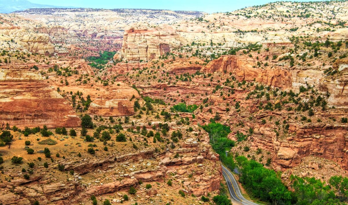
Image above: Grand Staircase-Escalante National Monument, Utah, 2006. Photo by Wolfgang Staudt (Wikimedia Commons, Creative Commons Attribution 2.0 Generic license, image cropped and resized).
The big picture
The geologic history of the southwestern United States spans more than two billion years. This history is unusually well exposed throughout the area’s extraordinary geological landscape, including spectacular mountains, canyons, and countless other striking features. The Southwest’s dynamic geologic history has resulted in the formation, preservation, and exposure of rocks from a wide variety of ages and sources. Rocks exposed in the Southwest reveal that a large continental mass—a supercontinent—was repeatedly assembled and disassembled over hundreds of millions of years. By around 600 million years ago, the core of what would eventually become most of North America was recognizable. Over the next several hundred million years this continent was mostly tectonically stable and flat, and was repeatedly flooded and exposed by rising and falling sea levels.
Around 300 million years ago, episodes of tectonic activity and volcanism added land to the continent along what would become the West Coast. Major mountain-building events (orogenies) began around 100 million years ago, and reached their peak around 66 million years ago, at the very end of the Mesozoic era. These orogenic episodes formed the modern Rocky Mountains, which have dominated the geology and landscape of western North America ever since.
At the same time that the Rockies were rising, globally high sea level caused an enormous shallow sea—the Western Interior Seaway—to form across what is today the Great Plains, from Texas to Alaska. This seaway disappeared in the early Cenozoic Era and was replaced by a changing landscape of forest and grasslands filled. Mammals replaced dinosaurs in most of the ecological niches for large terrestrial vertebrates. In the late Cenozoic, glaciers shaped the mountain landscape and the creatures that inhabited it.
The southwestern states are divided into four different physiographic provinces or regions: 1) the Colorado Plateau, 2) the Basin and Range, 3) the Rocky Mountains, and 4) the Great Plains. Each of these regions has a different geological history and thus varies in terms of rocks, fossils, topography, mineral resources, soils, and other geological features.
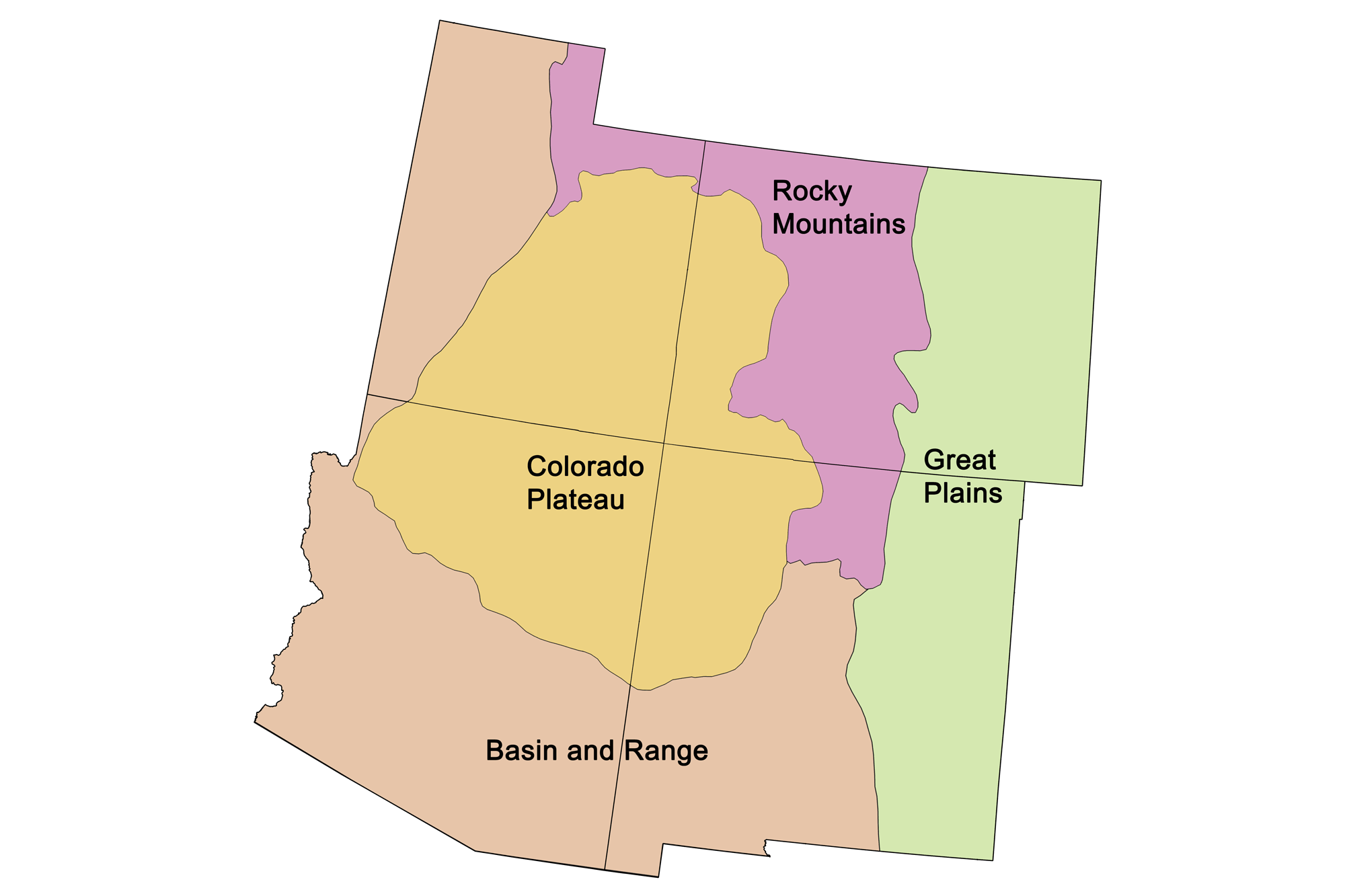
Physiographic provinces of the southwestern United States.
Precambrian (4.6 billion to 541 million years ago)
Hadean to Paleoproterozoic (4.6 to 1.6 billion years ago)
The Earth is estimated to be approximately 4.6 billion years old, an age obtained by dating meteorites. On the early Earth, continents formed and grew during pulses of magmatic activity, as bodies of molten rock deep in the Earth’s crust contributed to the formation of new crust. This crust makes up the cratons, or stable shields, of continental landmasses. The core of the North American continent is the Canadian Shield, which forms part of northern and eastern Canada (including the Canadian Arctic Archipelago) and a small part of the Great Lakes region in the northern United States. The oldest known rocks on Earth are 4.3-billion-year-old rocks found along the eastern shore of Hudson Bay in northern Quebec, Canada.
Most of the Southwest’s cratonic rocks are deeply buried. The oldest known rocks found at the surface are late Archean to early Proterozoic metamorphic rocks known as the Grouse Creek Block and the Farmington Canyon Complex in what is now northwestern Utah. These two sets of rocks were metamorphosed between 2.5 and 2.6 billion years ago, near the end of the Archean Era.
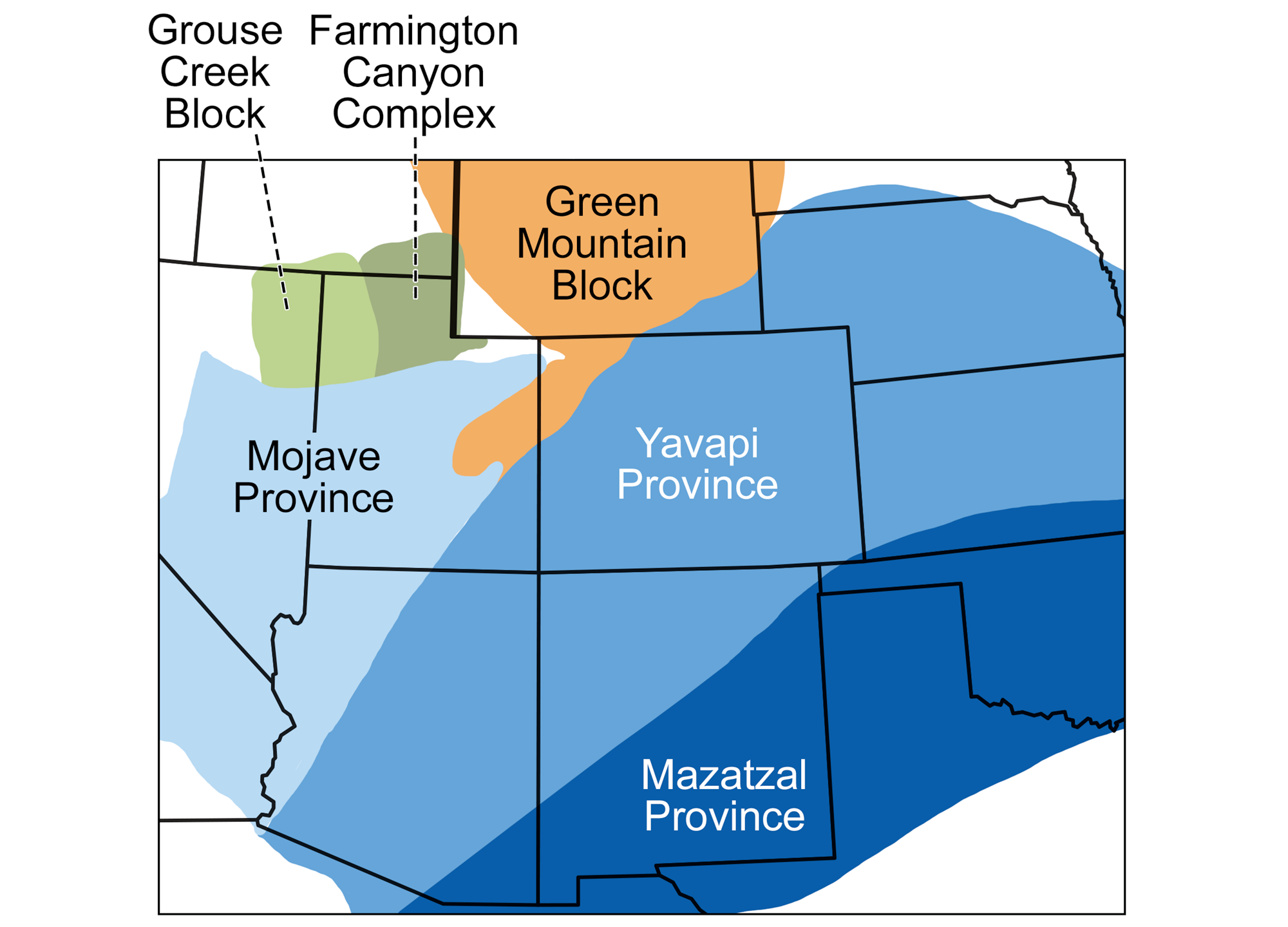
Cratonic elements of the southwestern United States. Map modified from an image by Wade Greenberg-Brand (adapted from an image by the USGS) originally published in The Teacher-Friendly Guide to the Earth Science of the Southwestern US.
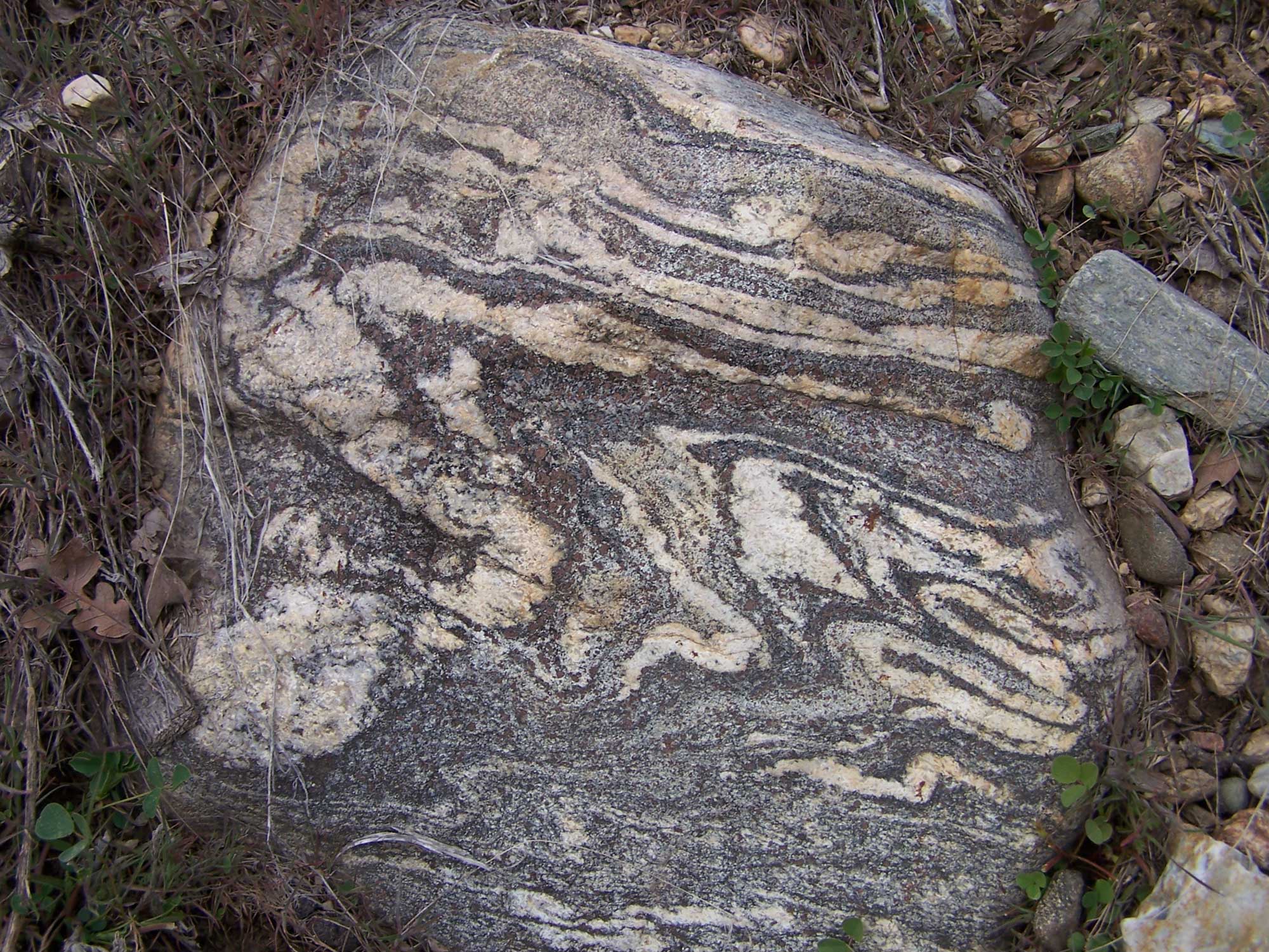
Precambrian garnet-containing gneiss, Farmington Canyon Formation. Photo by Bryant Olsen (flickr, Creative Commons Attribution-NonCommercial 2.0 Generic license, image resized).
The subsurface basement rock that underlies much of the Colorado Plateau is made up of cratonic elements, called provinces, that are about 1.8 to 1.6 billion years old. This basement rock is divided into three provinces: 1) the Mojave Province in western Arizona and Utah; 2) the Yavapai Province in Colorado, central Arizona, northwestern New Mexico, and southeastern Utah; and 3) the Mazatzal Province in southeastern Arizona and New Mexico. These provinces accreted to the edge of Laurentia (the ancient North American continent) in orogenic (mountain-building) events. The collision zones between the provinces are preserved as long belts of deformed metamorphic rock. Yavapai Province rocks are visible at the bottom of the Grand Canyon in northern Arizona.
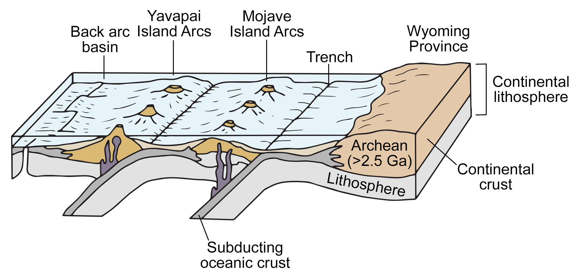
Plate tectonic model for the formation of crust by the addition of island arcs to the continent. These terranes (rock units formed by the island arcs) are some of the oldest rocks in the Grand Canyon. In this diagram, offshore island arcs (Mojave and Yavapai) are approaching the margin of Laurentia (the ancient North American continent). Modified from a diagram by Wade Greenberg-Brand (adapted from an image by Karlstrom et al. 2012, Geological Society of America Special Papers 489, pp. 7–24) originally published in The Teacher-Friendly Guide to the Earth Science of the Southwestern US.
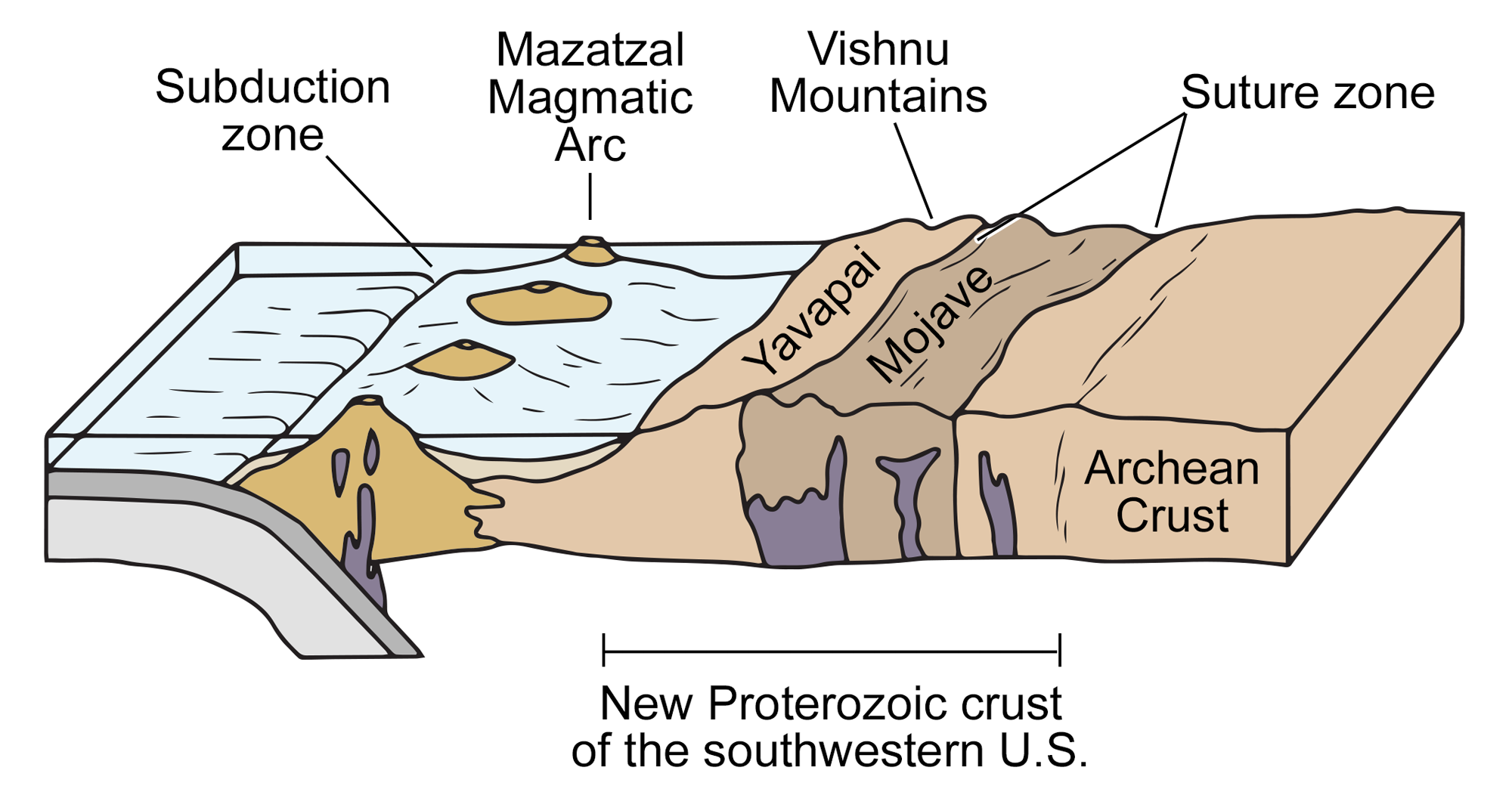
Plate tectonic model for the formation of crust by the addition of island arcs to the continent. These terranes (rock units formed by the island arcs) are some of the oldest rocks in the Grand Canyon. In this diagram, an offshore island arcs (Mazatzal) is approaching the margin of Laurentia (the ancient North American continent), to which the Mojave and Yavapai terranes have already accreted. Modified from a diagram by Wade Greenberg-Brand (adapted from an image by Karlstrom et al. 2012, Geological Society of America Special Papers 489, pp. 7–24) originally published in The Teacher-Friendly Guide to the Earth Science of the Southwestern US.
The Mesoproterozoic to Neoproterozoic (1.6 billion to 541 million years ago)
By the Mesoproterozoic Era, about 1.1 billion years ago, the supercontinent Rodinia had formed. Preserved remnants of the continental collisions that formed this supercontinent are found widely across modern North America, including the Pikes Peak Granite in Colorado. Other remnants are found outside the southwestern U.S. in the Llano province and El Paso region of western Texas, and farther to the east in the Grenville rocks of the Adirondack and Appalachian mountains.
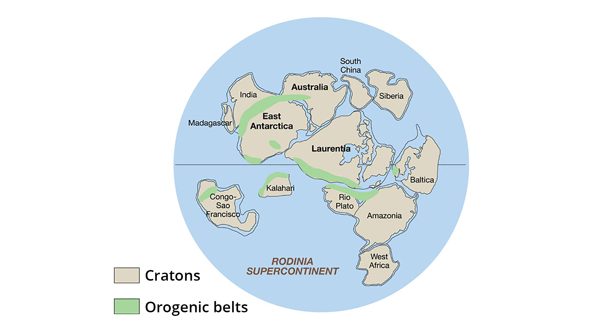
The supercontinent Rodinia, around 1.1 billion years ago. Laurentia represents proto-North America. Image adapted from original created by John Goodge for the United States Geological Survey (public domain).
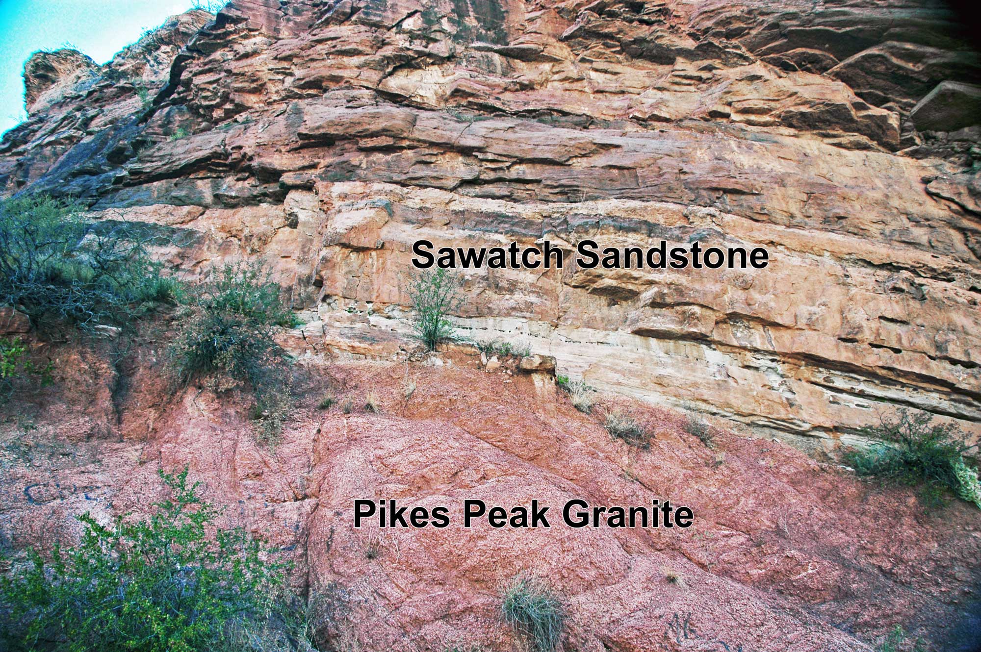
Mesoproterozoic Pikes Peak Granite underlaying the Cambrian Sawatch Sandstone, El Paso County, Colorado. An unconformity Photo by James St. John (flickr, Creative Commons Attribution 2.0 Generic license, image labeled and resized).
The breakup of Rodinia, beginning nearly 800 million years ago, was associated with the formation of rifts throughout North America. Igneous activity occurred in rifted zones and continued slowly and irregularly until about 600 million years ago. North America’s rifted edges formed passive margins, where sediments were deposited on continental shelves into the early Paleozoic era.
The rifted margin of western North America became a shallow continental shelf that extended from Canada through western Utah into southern California. Rivers brought sediment from the continent’s interior and deposited it on the shelf. In Arizona, these sediments form a thick sequence of sedimentary layers known as the Grand Canyon Supergroup, which constitutes one of the most complete middle to late Proterozoic geologic records in North America. These rocks record a long history—perhaps 200 million years—between the formation of continental crust by terrane collision and accretion to the more familiar events of the Cambrian period and later.
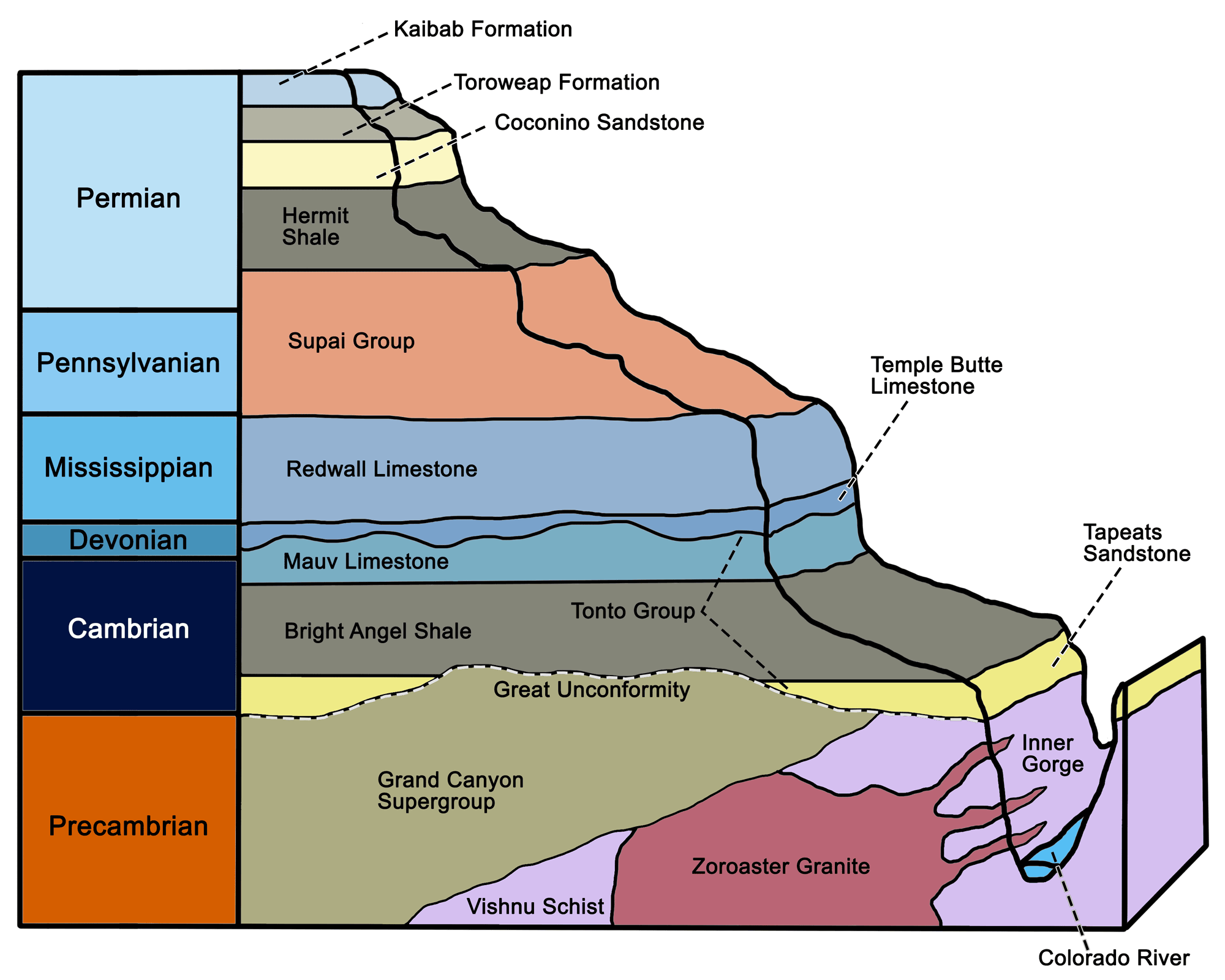
Major Proterozoic and Paleozoic stratigraphic units of the Grand Canyon and Colorado Plateau. Modified from a diagram by Wade Greenberg-Brand originally published in The Teacher-Friendly Guide to the Earth Science of the Southwestern US.
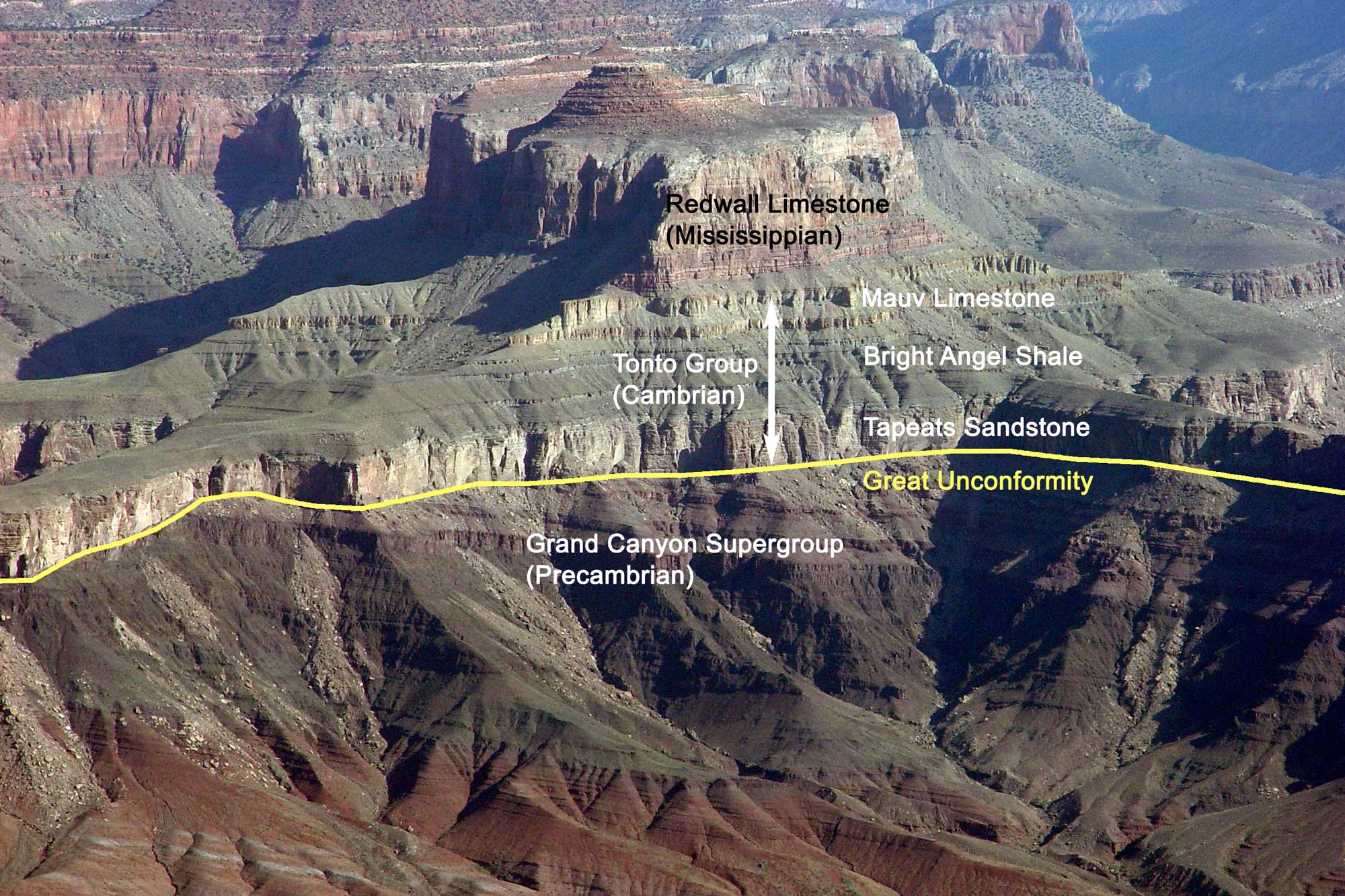
The Great Unconformity (marked by the line) in the Grand Canyon, Arizona, where the horizontal Tonto Group (Cambrian) overlies the tilted Grand Canyon Supergroup (Proterozoic). Image by Jonathan R. Hendricks for the Earth@Home project.
During the late Proterozoic, large areas of the continents were repeatedly covered with glaciers, including some that reached into low latitudes. Many geologists think that this interval may have included the most intense and widespread glacial development in Earth’s history. The term “Snowball Earth” is used to describe this proposed state, during which most of the Earth’s surface (pole-to-pole) was covered by glaciers. In the Southwest, geological evidence for this glacial expansion is represented by rocks formed from glacially derived sediments (tillites) found in western Utah.
Mineral Fork Formation tillite (glacial deposit), Neoproterozoic, Antelope Island, Utah. Photo by Bryant Olsen (flickr, Creative Commons Attribution-NonCommercial 2.0 Generic license, image resized).
Paleozoic (541 to 252 million years ago)
Cambrian to Silurian (541 to 419 million years ago)
The rifting of Rodinia produced a passive margin on the western edge of Laurentia. At the start of the Paleozoic, during the Cambrian, the area that now comprises the states of California, Oregon, Washington, and western Nevada did not exist as part of the North American continent. The continent’s western coastline was located at approximately the Utah-Nevada and Arizona-California state lines, where a broad continental shelf extended westward from the coast. The shore moved eastward over time as sea level rose, covering much of the western US under a shallow (epicontinental) sea. Sheets of sand and carbonate sediment were deposited on the continental shelf.
During the late Cambrian and early Ordovician, the entire shelf was covered by a huge carbonate platform, much like the region around today’s Bahama Islands. At other times, such as the late Ordovician, transgression paused or reversed (regression), and the sea deposited thin sheets of nearly pure quartz sand.
At the end of the Ordovician, global temperatures and sea level fell abruptly, probably due to glaciation caused by the movement of the large southern supercontinent Gondwana over the South Pole. As a result of these environmental changes, a major mass extinction of marine life took place. Sea level continued to rise and fall throughout the first half of the Paleozoic, depositing marine sediments during transgressions and allowing the exposed carbonate rocks to weather during regressions.
The globe about 485 million years ago, near the Cambrian-Ordovician boundary. Note that the south-central region of the U.S. is covered by a shallow sea. Reconstruction created using basemap from the PALEOMAP PaleoAtlas for GPlates and the PaleoData Plotter Program, PALEOMAP Project by C. R. Scotese (2016); map annotations by Jonathan R. Hendricks for PRI's Earth@Home project (CC BY-NC-SA 4.0 license).
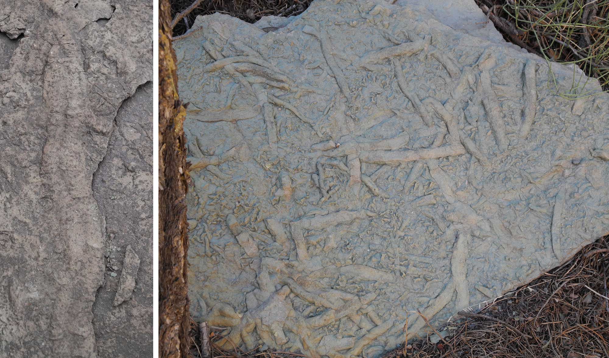
Trace fossils from Grand Canyon National Park, Arizona. Left: Cruziana, a type of trace fossil attributed to trilobites. Formation not identified, but probably Cambrian Tonto Group. (Length about 20 centimeters or 8 inches). Photo by Cassi Knight, Paleontology Guest Scientist (National Park Service, public domain). Right: Trace fossils (burrows and Cruziana) from the Cambrian Bright Angel Shale, Tonto Group. Photo by Cassi Knight, Paleontology Guest Scientist (National Park Service, public domain).
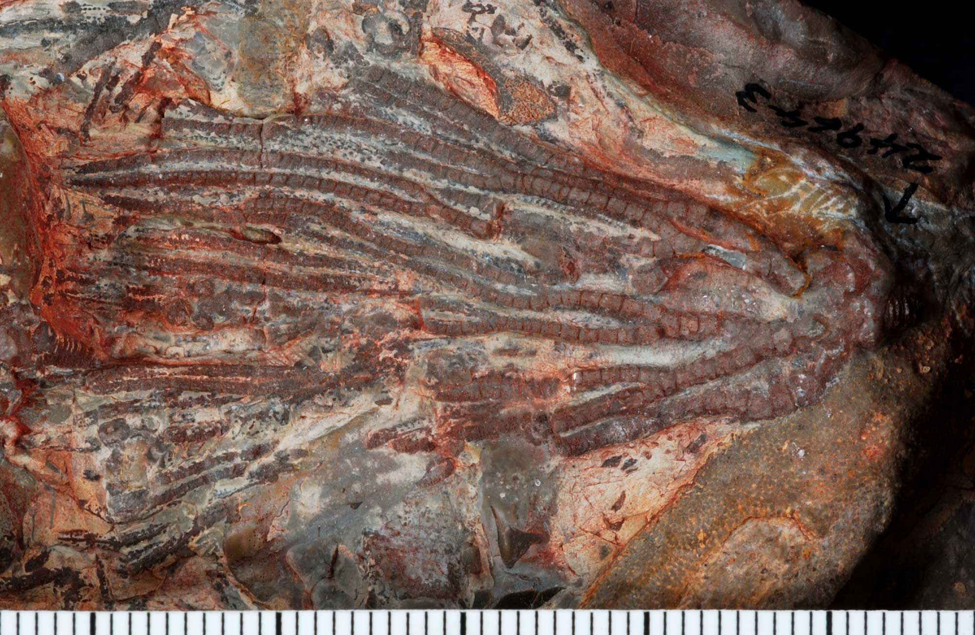
A crinoid (Pogocrinus antiquus) from the Ordovician Fillmore Limestone, Millard County, Utah. Photo of USNM PAL 249643 by Crinoid Type Image Project (Smithsonian National Museum of Natural History, public domain).
Devonian (419 to 359 million years ago)
In the late Devonian period (approximately 370 million years ago) a major geological change took place in the Southwest. A portion of the continental shelf adjacent to present-day Idaho and Nevada changed from a quiet passive margin to an active subduction zone, where oceanic crust plunged beneath the continent. Here, as oceanic crust descended deep into the upper mantle, the rock above the descending crust melted to form a line of volcanoes on the surface.
Subduction also led to accretion. Sediment, sedimentary rock, and even bits of the oceanic crust itself were scraped off the descending crustal plate and pushed onto the overlying plate. Just as a rug develops folds when pushed from the side, these rocks were wrinkled up into mountains. Volcanic islands carried along by the subducting plate also accreted to the edge of the continent. The landmass began to rotate, moving Laurentia (ancient North America) into a more modern orientation.
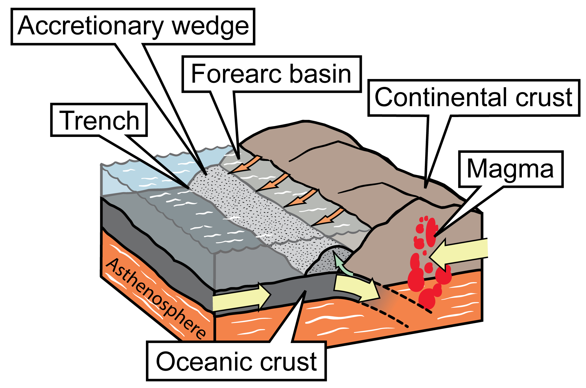
Simplified diagram of a convergent boundary at which continental crust and oceanic crust are colliding. The denser oceanic crust is subducted, or forced under, the more buoyant continental crust. The oceanic crust melts as it is subducted, and an accretionary wedge forms where the oceanic plate is scraped against the continental crust; in front of the wedge is a trench. Subduction of the oceanic crust produces magma, which wells up, causing volcanic activity. Image modified for Earth@Home from original by Jim Houghton, first published in The Teacher-Friendly Guide series (CC BY-NC-SA 4.0 license).
Carboniferous to Permian (359 to 252 million years ago)
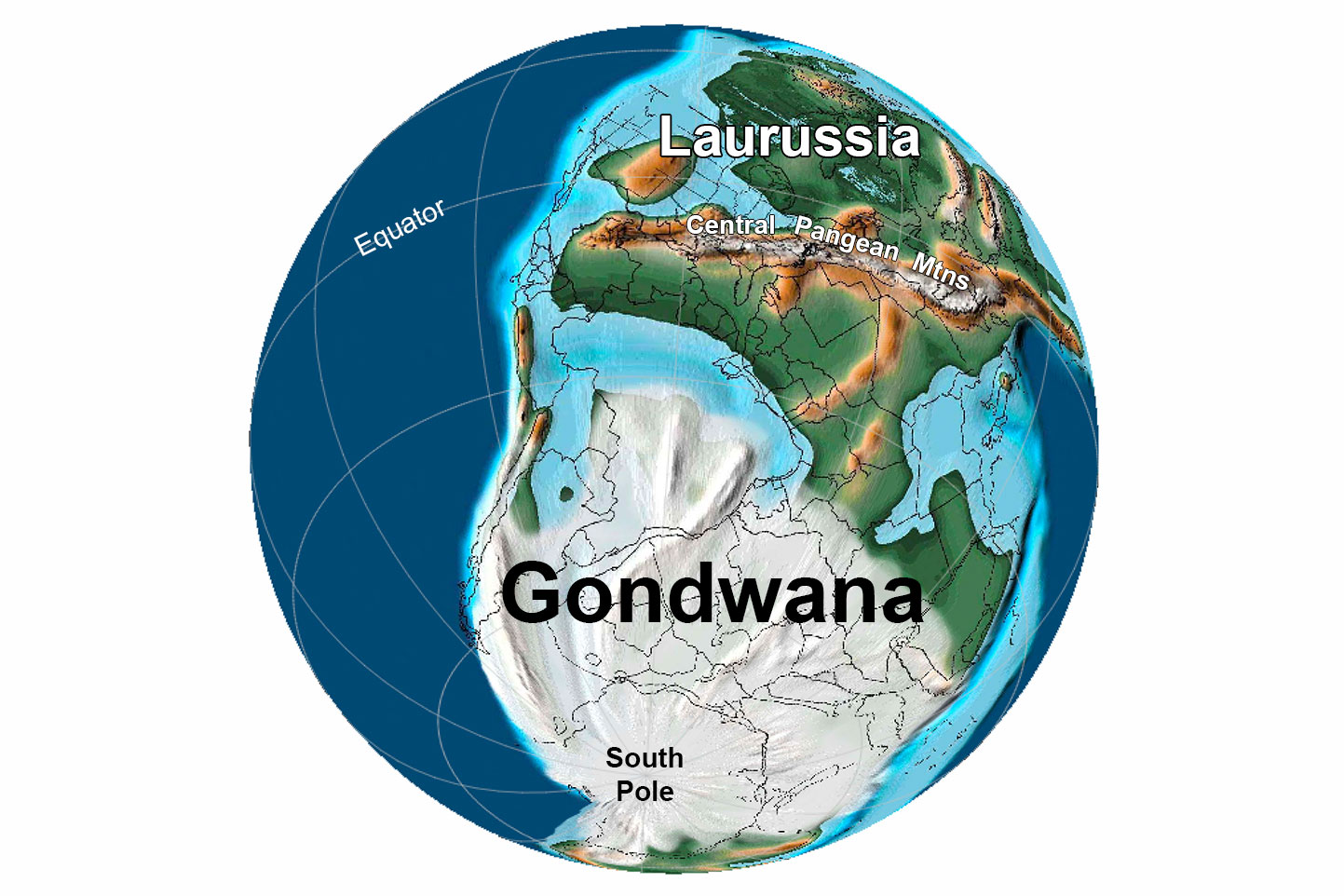
Sea level fell again during the Pennsylvanian and Permian, as continental collisions progressed to form the supercontinent Pangaea. As accretion continued over time, the coastline moved farther seaward, running through western Montana, eastern Idaho, central Utah, and western Arizona.
The climate at low latitudes on Pangaea was hot and dry, and iron-rich limestones, sandstones, and mudstones were oxidized. This process generated rocks with a distinctive and characteristic red color, appropriately called “red beds.” Permian red beds are very characteristic of the Southwest, particularly in the Colorado Plateau region, where they are the most widespread geologic feature exposed. Many of these red beds represent ancient dunes.
Meanwhile, the marine Permian Basin of southern New Mexico and west Texas was ringed by reefs—the Guadalupe Mountains of southern New Mexico and western Texas contain the largest and best-preserved Paleozoic reef in the world. Regression of the sea near the end of the Permian period spelled the end of the Southwest’s magnificent reefs.
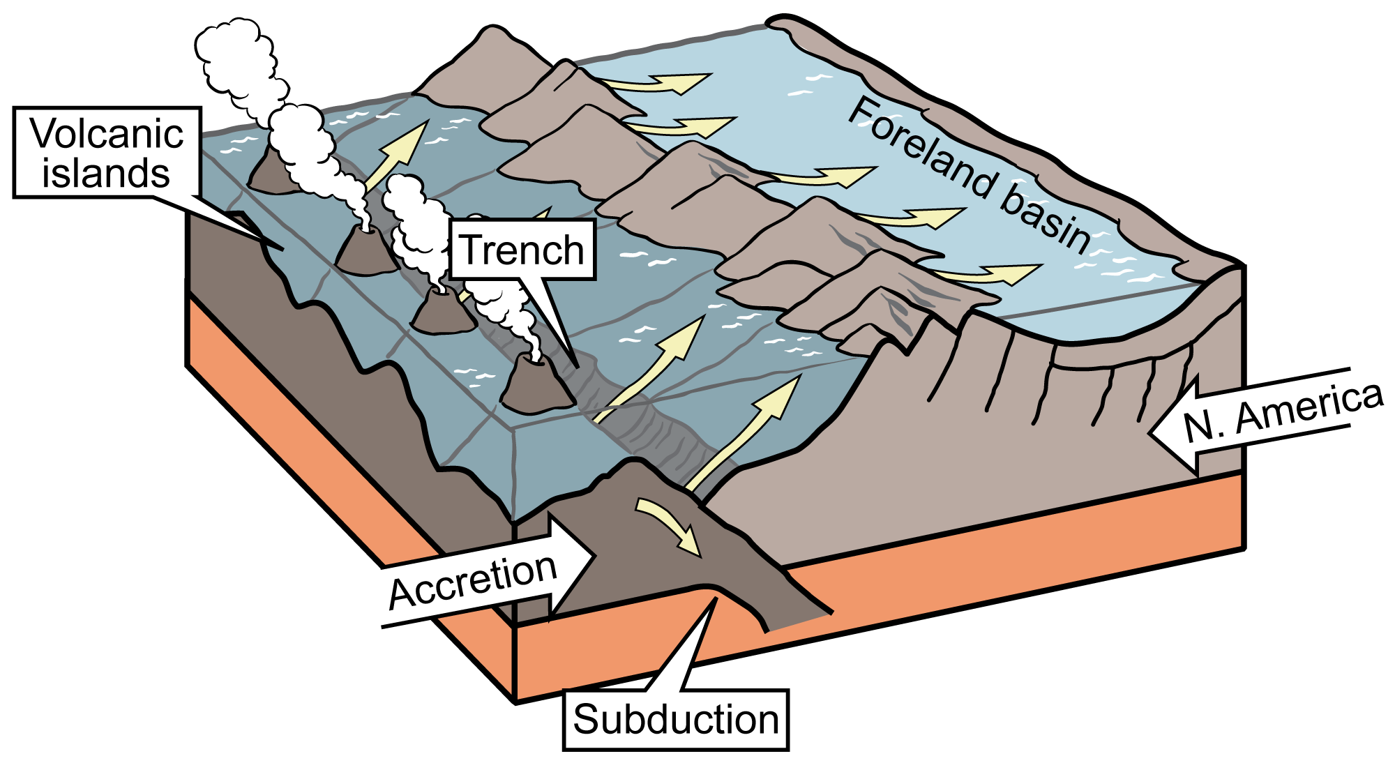
Formation of North America's foreland basin. Illustration by Jim Houghton, originally published in the Teacher Friendly Guide to Earth Science series, modified for Earth@Home.
Earth 300 million years ago, during the end of the Carboniferous Period (Pennsylvanian). The approximate location of the Interior Highlands region is circled in yellow. Reconstruction created using basemap from the PALEOMAP PaleoAtlas for GPlates and the PaleoData Plotter Program, PALEOMAP Project by C. R. Scotese (2016); map annotations by Jonathan R. Hendricks & Elizabeth J. Hermsen for PRI's Earth@Home project (CC BY-NC-SA 4.0 license).
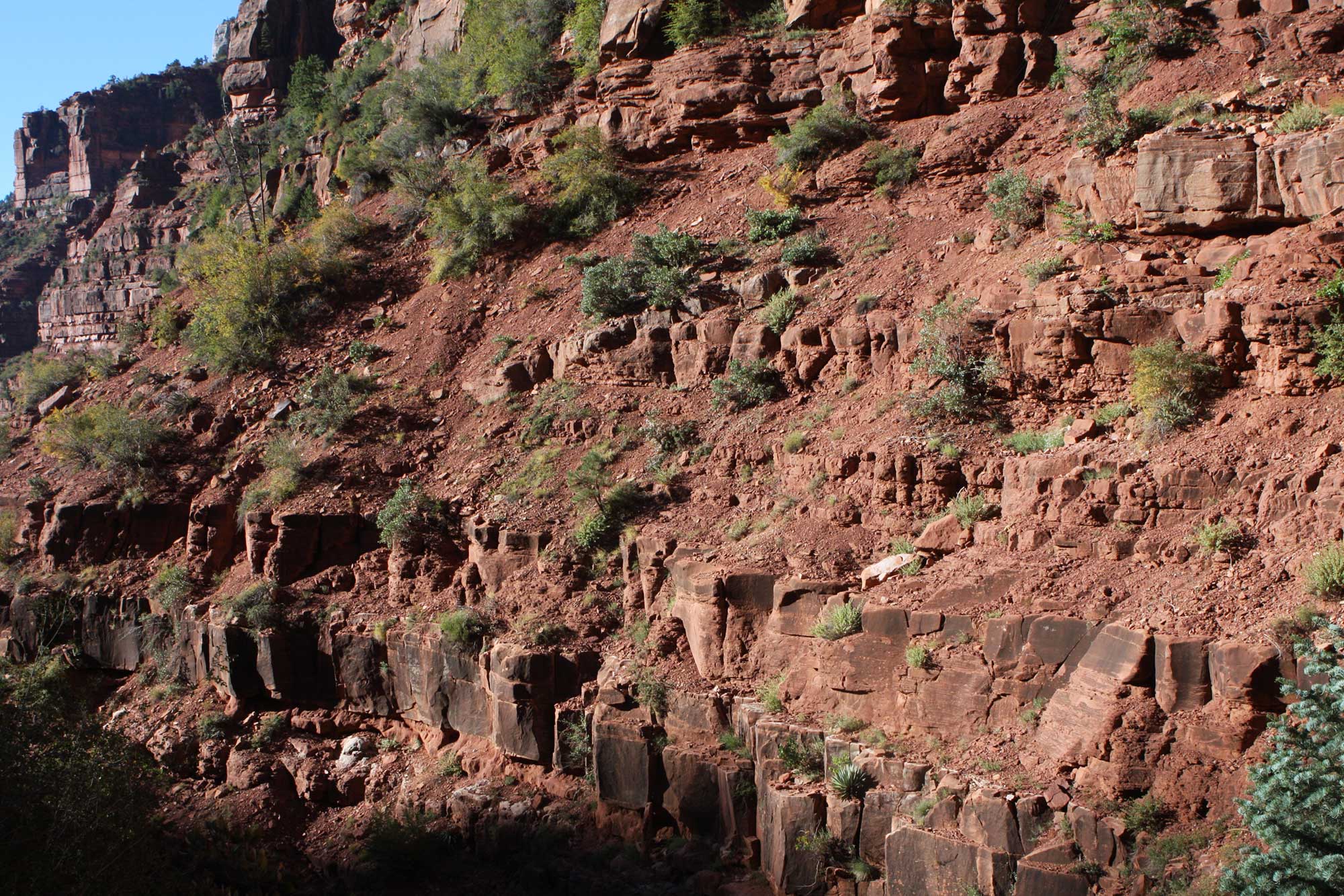
Red-colored rocks of the Hermit Shale (or Hermit Formation), Grand Canyon, Arizona, yield fossil plants. Photograph by brewbrooks (flickr, Creative Commons Attribution-ShareAlike 2.0 Generic license, image resized).
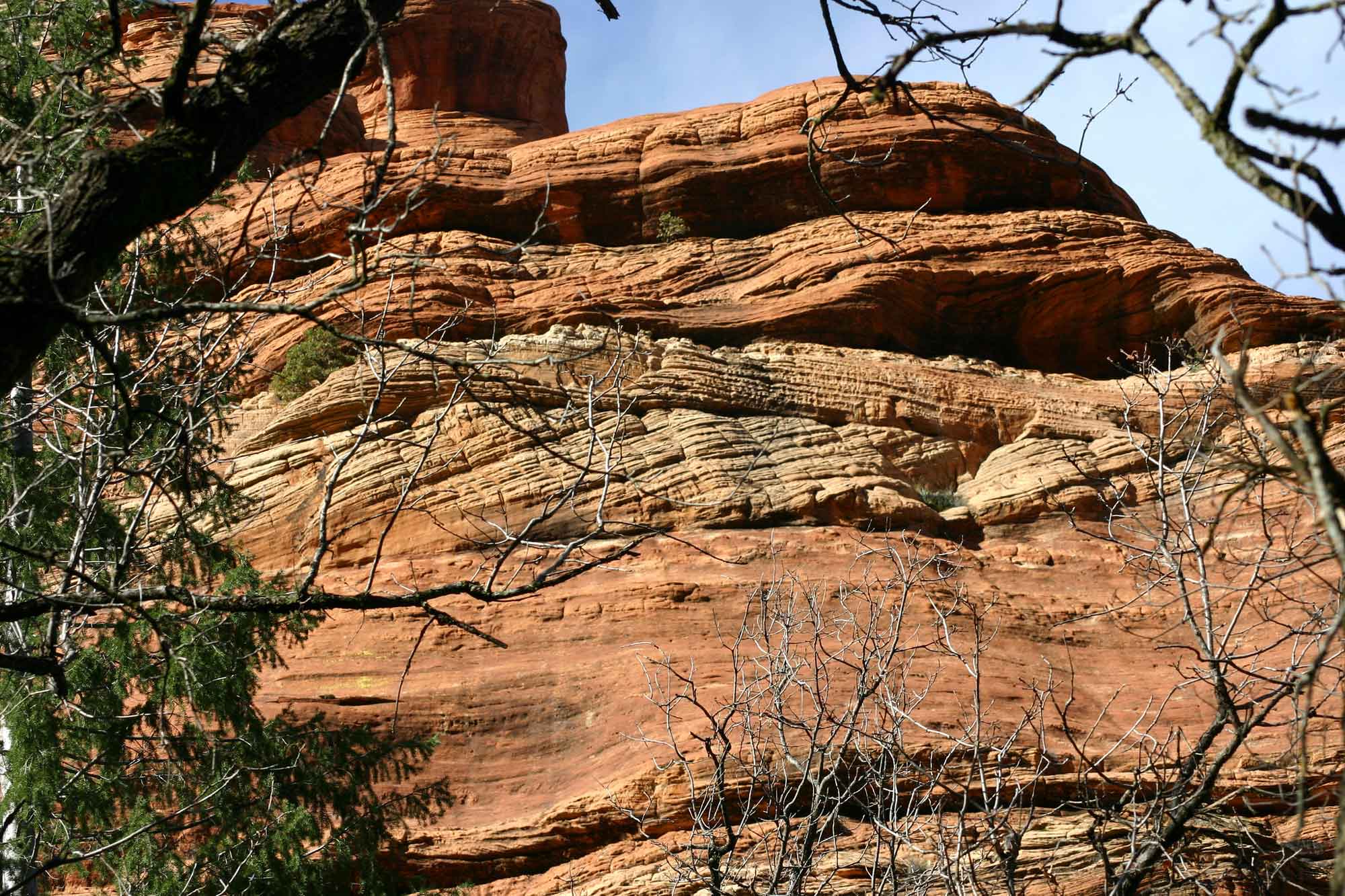
Cross-beds in the Coconino Sandstone at Sedona, Arizona. Photograph by Kevin Walsh (Flickr; Creative Commons Attribution 2.0 Generic license; image resized).
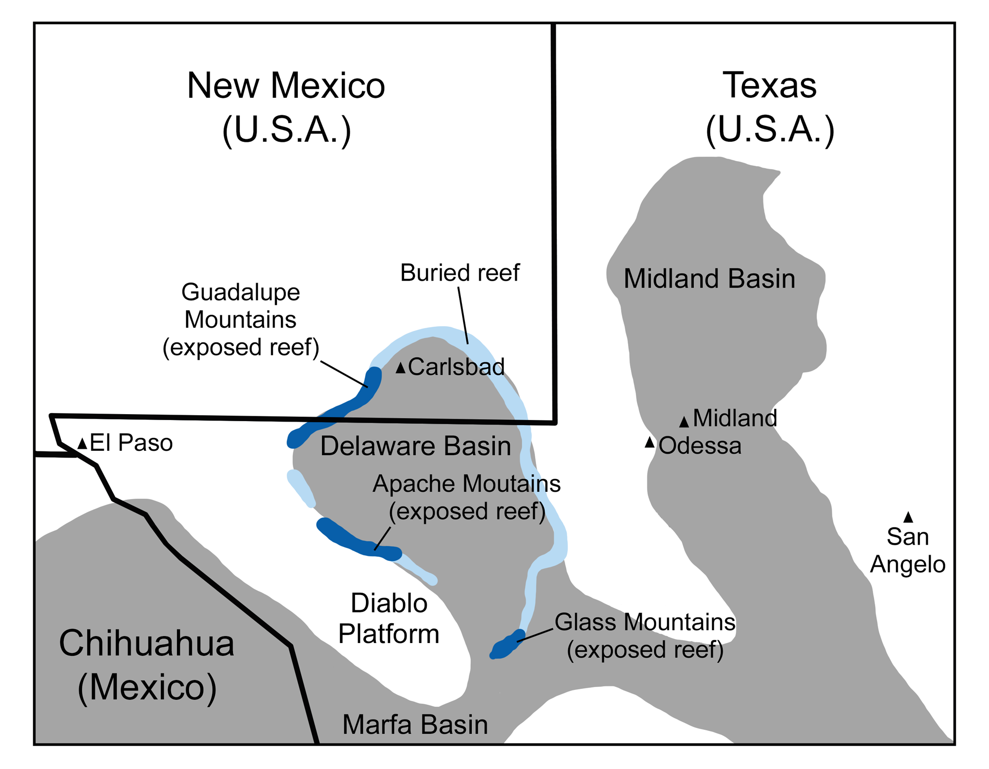
Permian reefs of New Mexico and Texas: Map showing the paleogeographic relationship of the reefs to the topographic lows and highs of the shallow sea that covered the Texas-New Mexico-Chihuahua region in the Permian. The reef occupied the rim of the Delaware Basin. Original map by Wade Greenberg-Brand, modified for the Earth@Home project.
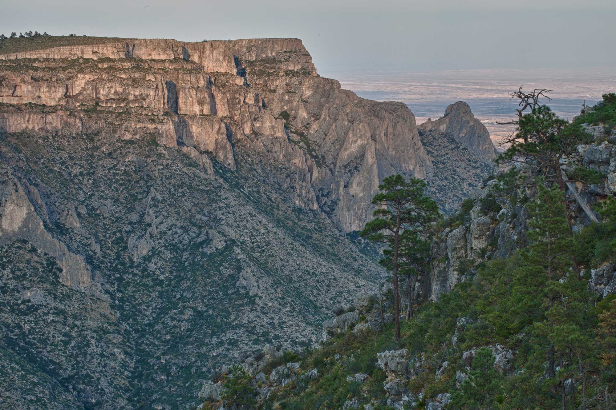
Lonesome Ridge Wilderness Study Area in the Guadalupe Mountains, southern New Mexico. The cliffs at the tops of the mountains in this area are part of the exposed Permian reef complex. Photo by Bob Wick, Bureau of Land Management California (BLM on flickr, Creative Commons Attribution 2.0 Generic license, image resized).
Mesozoic (252 to 66 million years ago)
The Mesozoic era is frequently known as the Age of the Dinosaurs, but many other life forms evolved and thrived during this time, including marine invertebrates, flowering plants, birds, and mammals. The Mesozoic was also a time of major geologic change during which great thicknesses of rocks were deposited across the southwestern U.S. The supercontinent Pangaea was in place by the end of the Permian period, and global sea level was probably at its lowest of any time during the past 600 million years. In the Southwest, the shoreline withdrew from central Utah to western Nevada.
Triassic (252 to 201 million years ago)
During the Triassic, Earth’s climate was much warmer than today, with an average global temperature of about 25°C. The Southwest was now largely dry land, and rocks from this period record complex and varied deposition in rivers and deserts. Subduction along the western margin of the Americas generated the Cordilleran volcanic arc, which was active throughout much of the Mesozoic.
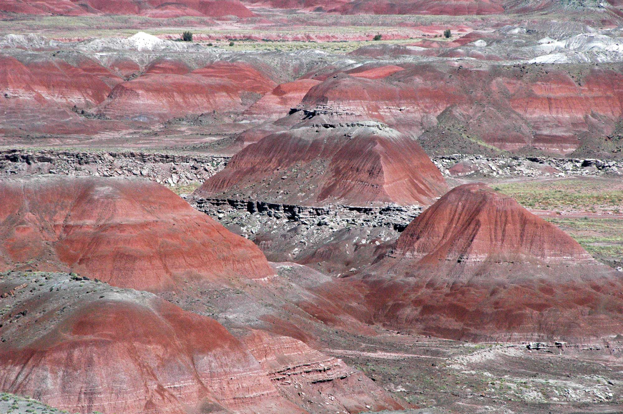
Triassic rocks of the Chinle Formation (particularly the Petrified Forest Member's Black Forest Beds) in the Painted Desert and Petrified Forest region record an influx of volcanic material from the Cordilleran arc, as well as sediment from adjacent highlands composed of sedimentary and plutonic rocks. Rocks from the Cordilleran arc are still present today in the Andes, Central America, the Cascades, and the Aleutians.
Badlands formed by erosion of rocks of the Triassic Petrified Forest Member, Chinle Formation, Arizona. Photo by James St. John (flickr, Creative Commons Attribution 2.0 Generic license, image resized).
Jurassic (201 to 145 million years ago)
Pangaea began to break up during the early Jurassic, and sea levels began to rise again. By the middle Jurassic, a shallow arm of the sea reached from Canada south through Montana and parts of Wyoming, Utah, and the Dakotas, depositing thin layers of limestone, mudstone, and sand. During the Jurassic, mudstone and sandstones were also deposited in lowland areas and river channels throughout the Rockies and Colorado Plateau; these formed the Morrison Formation, which is famous for its abundant dinosaur fossils.
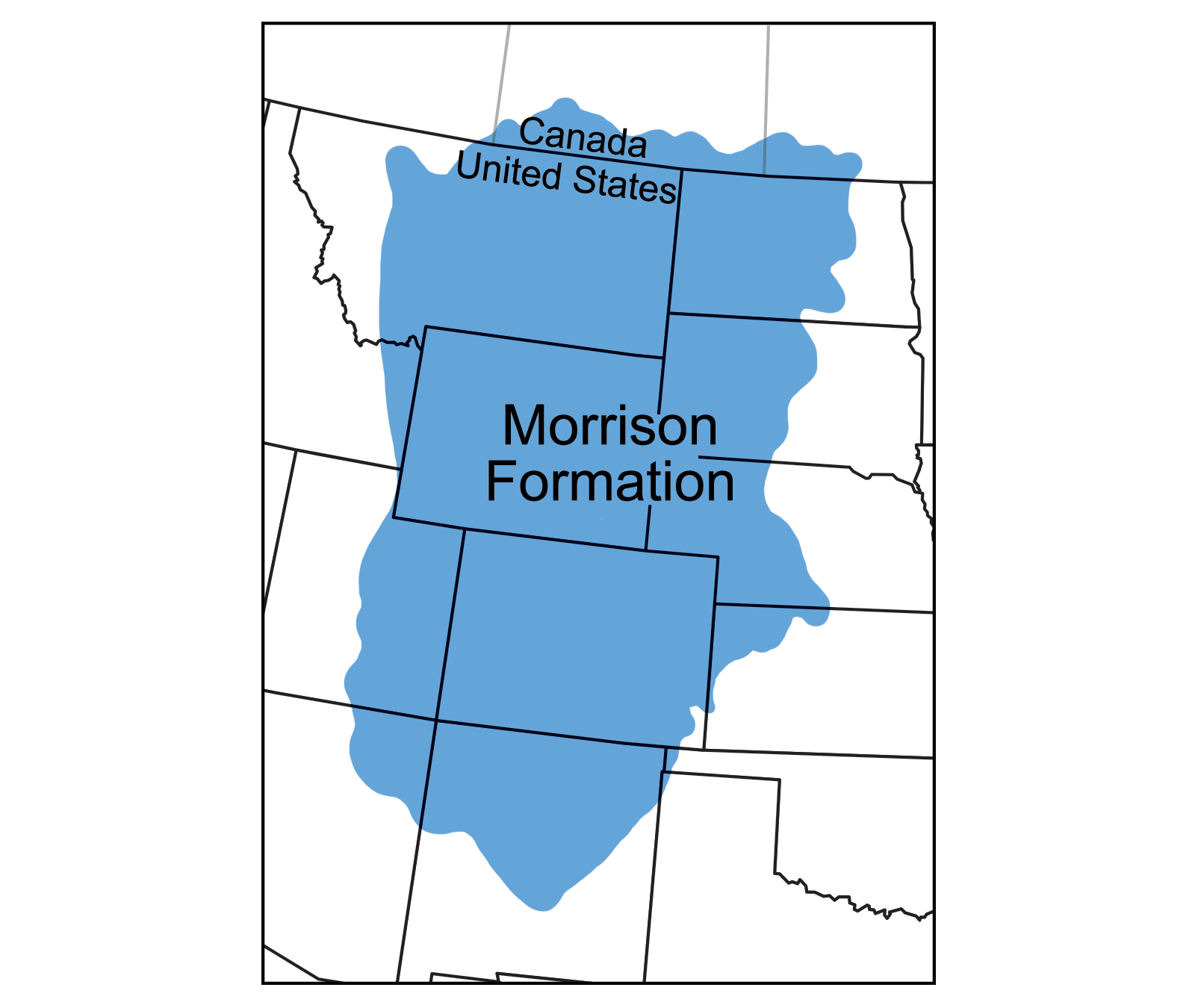
Geographic extent of the Jurassic Morrison Formation. Map modified from a map by Wade Greenberg-Brand, originally published in The Teacher-Friendly Guide to the Earth Science of the Southwestern US.
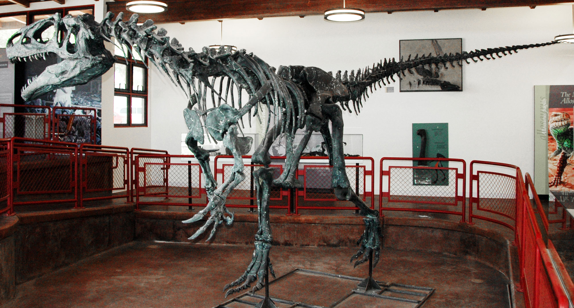
Allosaurus fragilis on display at the Cleveland-Lloyd Dinosaur Quarry, Utah. Photo by James St. John (flickr, Creative Commons Attribution 2.0 Generic license, image resized).
Cretaceous (145 to 66 million years ago)
The Farallon Plate
When the supercontinent of Pangaea came together in the late Paleozoic Era, most of the world's continents were combined into the single landmass of Pangaea. Because of this, most of the world's seawater was found in a single ocean called the Panthalassic Ocean. The Panthalassic Ocean was essentially the ancient Pacific Ocean.
By the early Jurassic period, much of the floor of the Panthalassic Ocean was made up of three large plates: the Izanagi plate in the northwest, the Farallon Plate in the northeast, and the Phoenix Plate in the south. The modern Pacific Plate first formed by seafloor spreading at the junction between these plates about 190 million years ago. Over time, the Pacific Plate continued to grow by seafloor spreading. Meanwhile, the Farallon Plate shrank in area as it was subducted beneath the western margin of Pangaea (the western margin of the present-day Americas).
The subduction of the Farallon plate played an important role in building mountains in North America during the Mesozoic and Cenozoic eras. Today, remnants of the Farallon Plate include the Juan de Fuca, Cocos, and Nazca plates that exist along the western margin of the Americas.
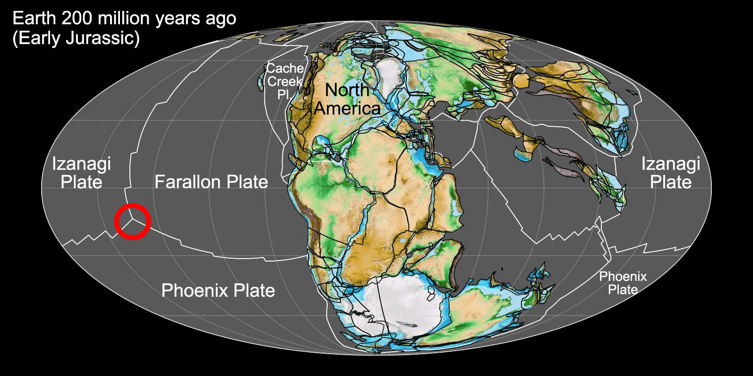
Earth 200 million years ago, showing Pangaea and the ancient Panthalassic Ocean (or the ancient Pacific). At this time, Earth's continents were combined into the supercontinent Pangaea. The floor of Panthalassa was largely made up of three plates, with the Farallon Plate bordering the western coast of ancient North America. The Pacific Plate, which makes up much of the floor of the modern Pacific ocean, originated at the junction between the Farallon, Izanagi, and Phoenix plates during the Jurassic Period (shown by the red circle on the map). Map by Fama Clamosa (Wikimedia Commons, Creative Commons Atribution-ShareAlike 4.0 International license, image cropped and labelled).
The Western Interior Seaway
During the Cretaceous, Pangaea entered its final stages of breakup. Far to the west, the Farallon plate had been subducting under western North America for tens of millions of years, causing a series of volcanic island complexes to collide with and become accreted to that margin of the continent. As oceanic crust was subducted beneath the continent, the Sierra Nevada of California was formed.
Several events led to the formation of the Western Interior Seaway, a sea extending from the Arctic Ocean to the Gulf of Mexico across the North American continent. The new Atlantic Ocean widened, and sea levels began to rise due to increased activity at oceanic spreading centers (mid-ocean ridges) that displaced seawater. The Farallon plate began to subduct at an unusually shallow angle, sliding farther inland beneath western North America before finally sinking into the asthenosphere. This downwarped the center of the continent and created a basin that allowed the waters of the Gulf of Mexico to meet with those in the north, forming the Western Interior Seaway. This shallow inland sea inundated a 1000-kilometer (620-mile) wide swath from Mexico to Alaska, separating North America into an Appalachian island to the east and a mountainous Cordilleran island to the west.
Erosion from these western mountains resulted in deposition of thick layers of sediment throughout the seaway. During the very latest stages of the Cretaceous period, around 70 million years ago, the Western Interior Seaway was displaced by slow uplift of the continent. The Farallon plate continued to collide with western North America, thrusting layers of rock up over each other and causing increasing volcanism to the west of the Western Interior Seaway.
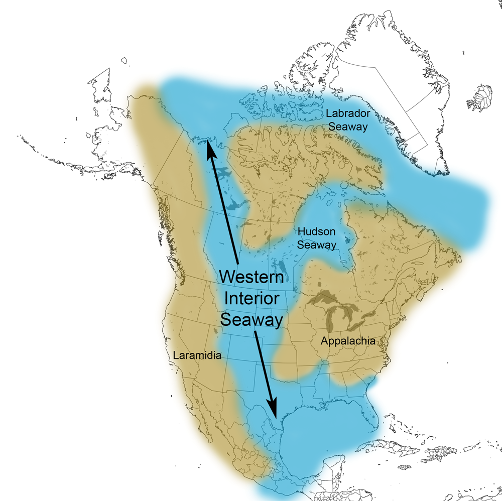
Extent of the Western Interior Seaway during the Cretaceous Period. Image from Cretaceous Atlas of Ancient Life: Western Interior Seaway (Creative Commons Attribution-NonCommercial-ShareAlike 4.0 International license).
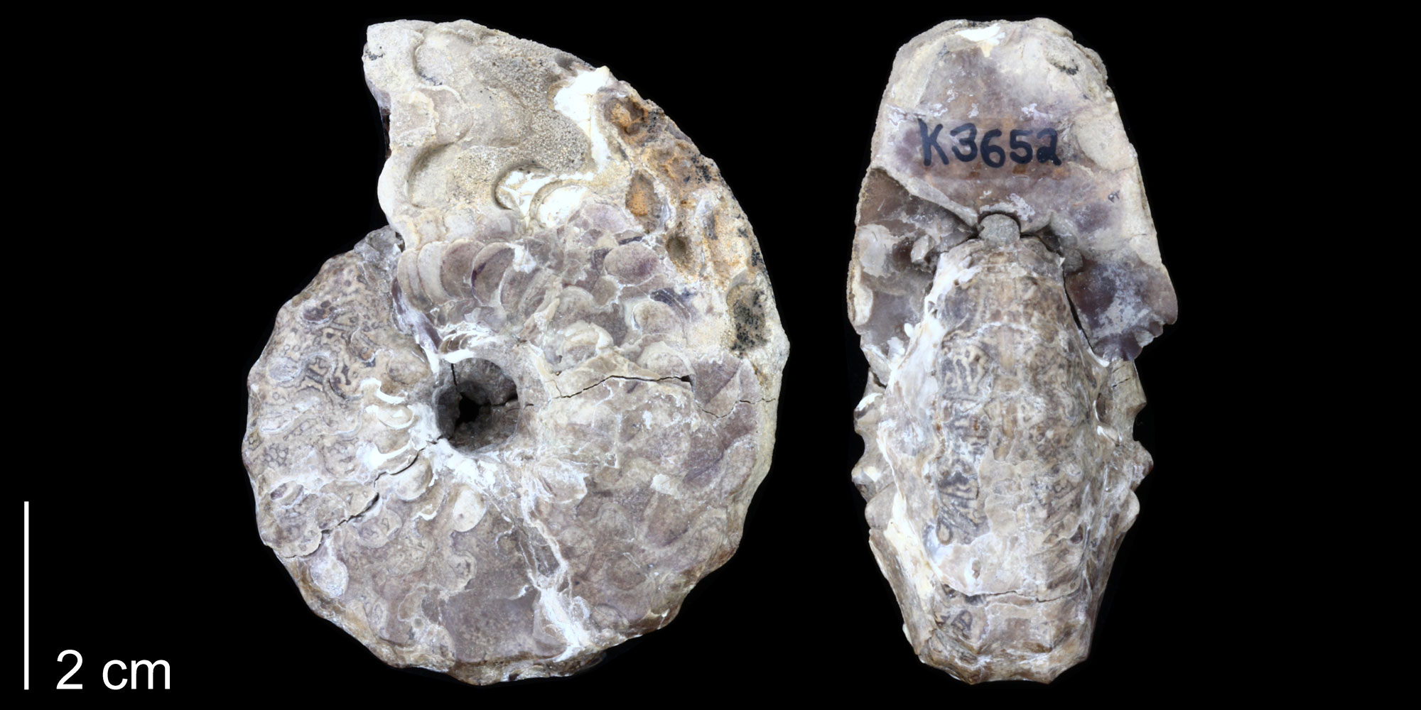
An ammonite (Spathites puercoensis), Late Cretaceous (likely Mancos Shale), Sandoval County, New Mexico. Photo of specimen PRI 70328 (Paleontological Research Institution, via Cretaceous Atlas of Ancient Life, Creative Commons Attribution-NonCommercial-ShareAlike 4.0 International license).
Uplift of the Rocky Mountains
The compressional forces of subduction faulted the crustal rocks of western North America and uplifted the Rocky Mountains in two major pulses. The Sevier Orogeny (100–72 million years ago) formed an extensive belt of and folds, also known as the “Overthrust Belt,” extending from the Sierra Nevada in California to the edge of the Colorado Plateau in western Utah.
The second event, the Laramide Orogeny, peaked around 68 to 65 million years ago when the angle of the subducting plate became shallower. This formed mountains farther inland than would normally be expected above a subduction zone, uplifting the Rocky Mountains in Wyoming, Colorado, and New Mexico.
These mountain ranges are bounded by thrust faults. Because the crust flexes or breaks under compression, several inland basins formed between the mountain ranges, and the eroding mountains shed thick layers of sediment into these basins, forming conglomerates, sandstones, and mudstones. The Colorado Plateau remained stable during this time of compression, and persisted during the subsequent episode of extension that followed from the Paleogene to the present day.
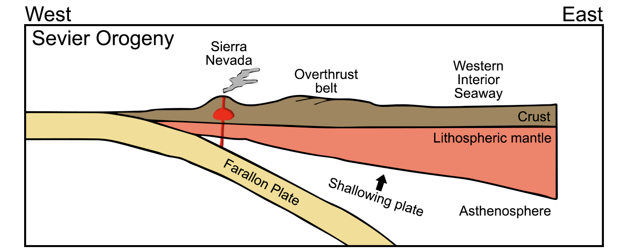
Diagram of the subduction of the Farallon plate during the Cretaceous Sevier Orogeny. The Wester Interior Seaway formed when the continental crust was downwarped in the central region of the North American continent. Diagram by Wade Greenberg-Brand, adapted from an image by the New Mexico Institute of Mining and Technology, originally published in the Teacher Friendly Guide to Earth Science series. Modified for Earth@Home.
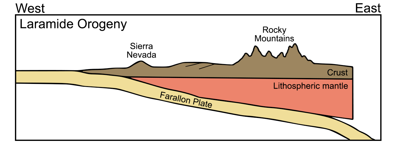
Diagram of the subduction of the Farallon plate during the Late Cretaceous to Paleogene Laramide Orogeny. During this orogeny, the Western Interior Seaway closed and the Rocky Mountains were uplifted. Diagram by Wade Greenberg-Brand, adapted from an image by the New Mexico Institute of Mining and Technology, originally published in the Teacher Friendly Guide to Earth Science series. Modified for Earth@Home.
The end-Cretaceous extinction
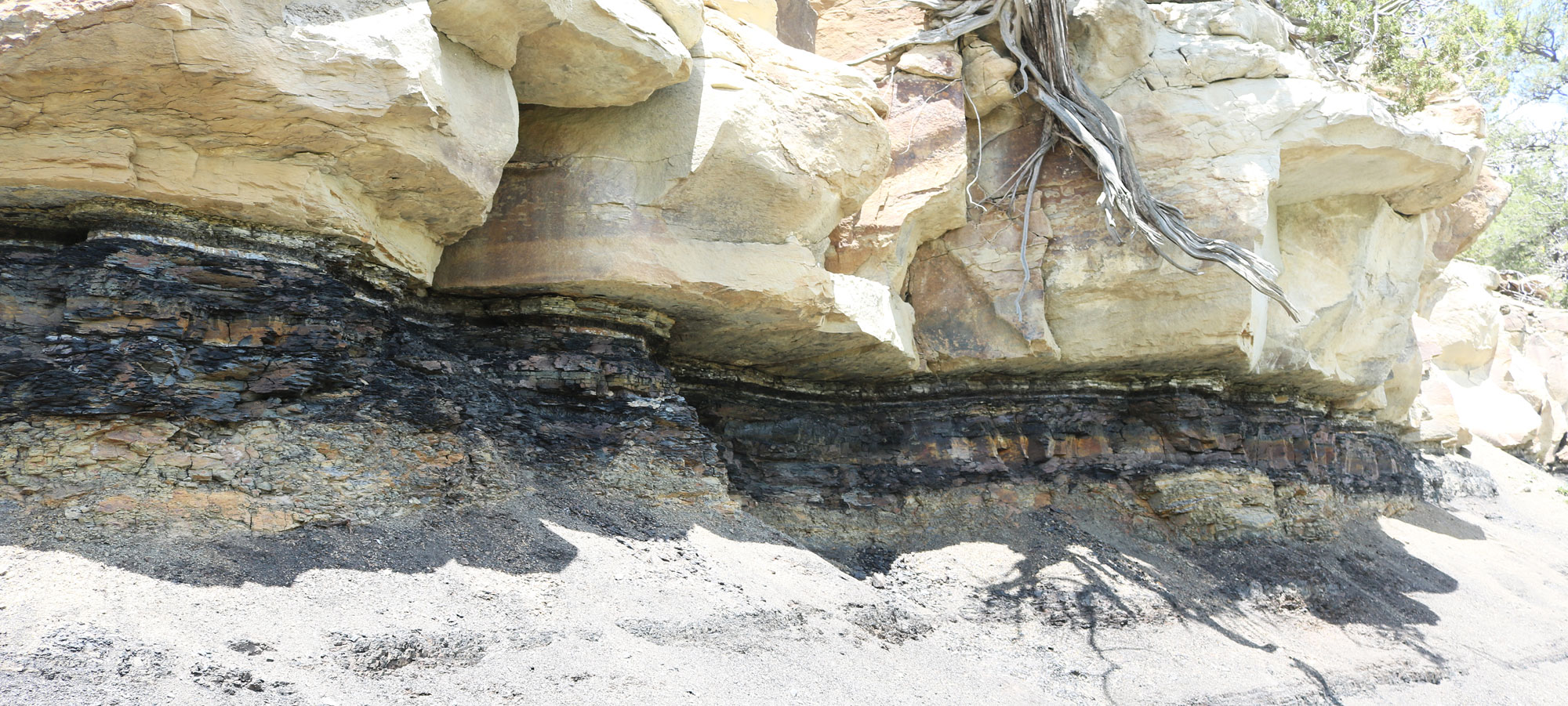
The Cretaceous-Paleogene (K-Pg) boundary (previously known as the Cretaceous-Tertiary or K-T boundary) marks one of the most significant physical and biological events in Earth history. The boundary marks the contact between the Mesozoic and Cenozoic eras at around 65 million years ago, representing a time during which a large proportion (perhaps 50–70%) of all species of animals and plants abruptly became extinct. The boundary itself is rarely preserved in the geologic record, due to incomplete sedimentation and widespread erosion. However, there are several southwestern localities, especially in northern New Mexico and southern Colorado, that preserve the K-Pg boundary layer.
The Cretaceous-Paleogene boundary at Trinidad Lake State Park, Las Animas County, Colorado. Photo by Jeffrey Beall (Wikimedia Commons, Creative Commons Attribution 4.0 International license, image resized).
Cenozoic (66 million years ago to present)
The Cenozoic era was an age of diversification and evolution of mammals, birds, insects, flowering plants, and coral reefs. Sea levels rose and fell, affecting the coastline, but the interior of North America remained relatively high. Sediment deposition, for the most part, occurred as fluvial and lake deposits. This was also a time of active volcanism in western North America. The Cenozoic geology of western North America is dominated by three large-scale processes: erosion, subduction and extension, and volcanic activity.
Paleogene (66 to 23 million years ago)
The Paleogene was a time of active volcanism around the world, and North America was no exception. Erosion of the mountains and highlands that had formed during the Mesozoic produced thick layers of conglomerates, sandstones, and mudstones across stream valleys, deltas, and lakes. Volcanic ash from nearby eruptions is commonly inter-layered with these sediments. Many of these sedimentary layers were deposited by rivers, or in alluvial fans coming from the mountain systems. Several such layers are now important aquifers, including the enormous Ogallala Aquifer which today supplies water for farming and communities on the Great Plains.
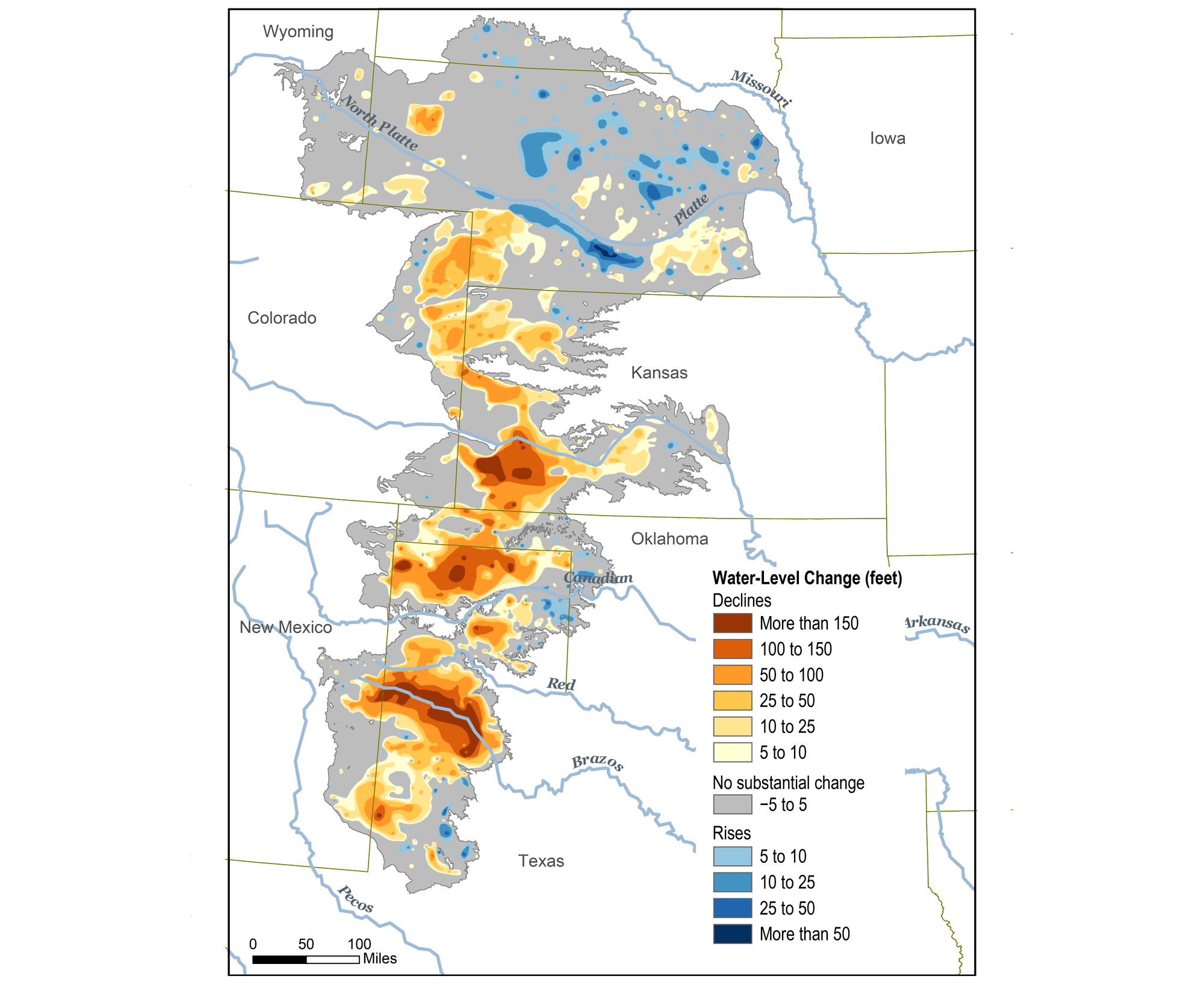
Original caption: "This map shows changes in Ogallala water levels from before the aquifer was tapped to 2015. Declining levels are red or orange, and rising levels are blue." Map from Climate.gov (NOAA).
Paleogene basins
Due to crustal deformation during the late Mesozoic and early Cenozoic, numerous basins formed inland lakes or depressions into which sediments were deposited. Some important basins, including the Denver and Raton basins in Colorado and the San Juan and Baca basins in New Mexico and Arizona, produce coal, oil, and gas, and other industrial minerals.
Perhaps the best-known basin, however, is the Green River Basin of western Wyoming and its equivalents, the Uinta Basin in northeastern Utah and the Piceance Basin in northwestern Colorado. Lakebed shales and mudstones found in all of these basins are famous for their abundant and well-preserved fossils.
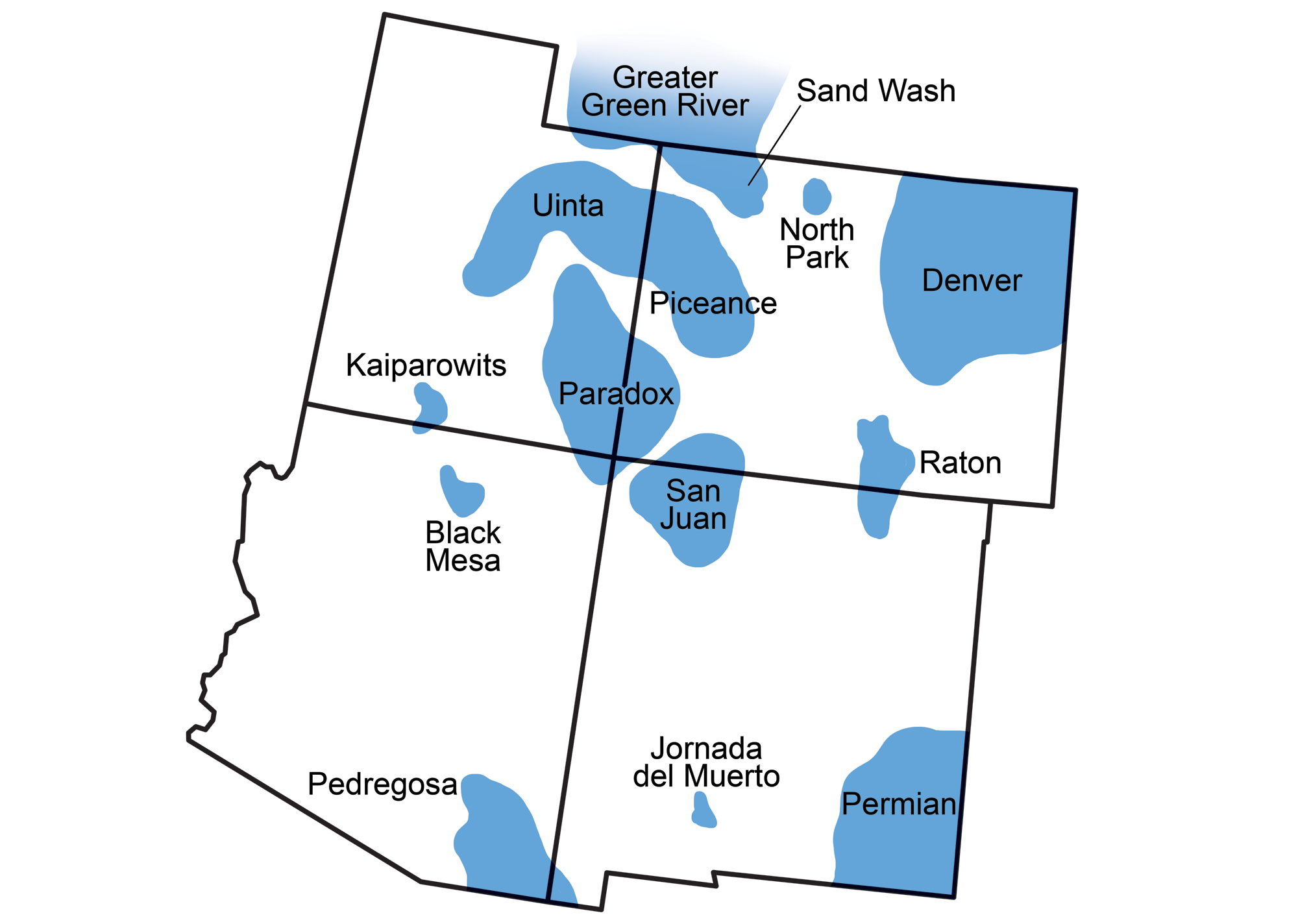
Sedimentary basins of the Southwest. Map modified from a map by Wade Greenberg-Brand originally published in The Teacher-Friendly Guide to the Earth Science of the Southwestern US.
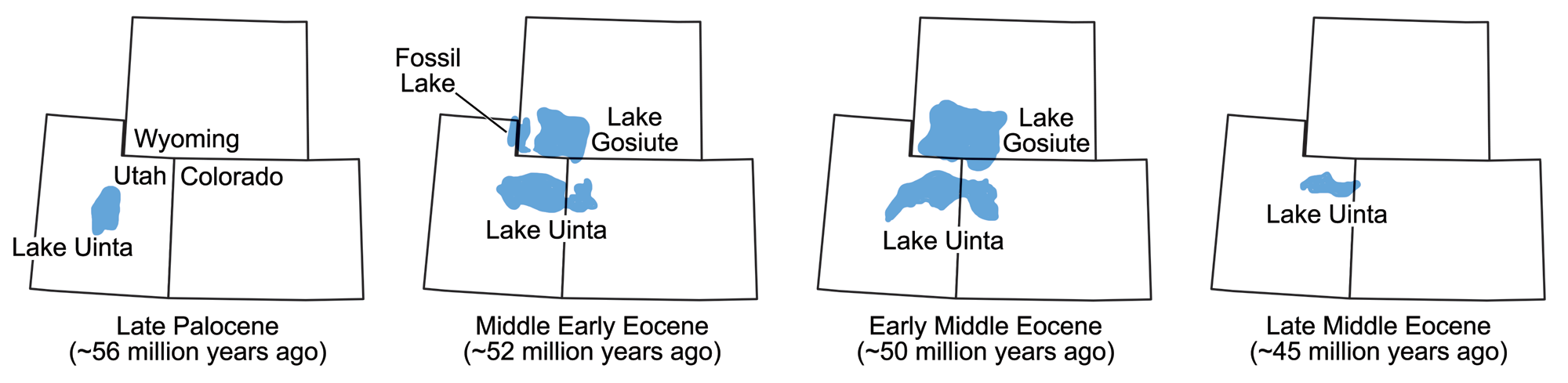
The size and location of various lakes in which the Green River Formation sediments were deposited during the Eocene epoch. Maps modified from maps by Wade Greenberg-Brand, originally published in The Teacher-Friendly Guide to the Earth Science of the Southwestern US, after figure 3 in L. Grande (2013) The Lost World of Fossil Lake.
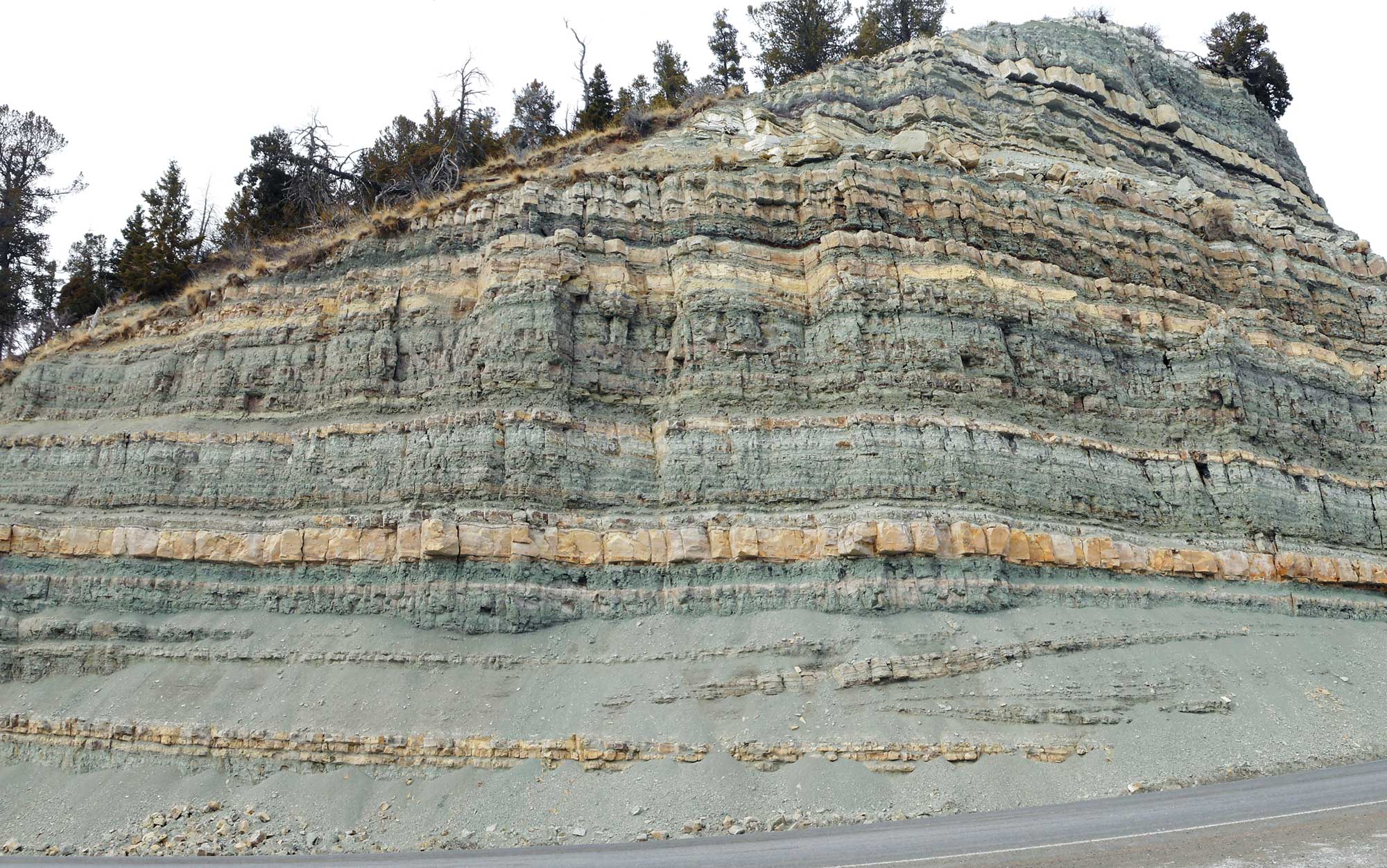
Roadcut exposing the Eocene Green River Formation, Duchesne County, Utah. Photo by Kenneth Carpenter (Wikimedia Commons, Creative Commons Attribution-ShareAlike 4.0 International license, image cropped and resized).
Paleogene volcanic fields
Between 40 and 30 million years ago, a transition from subduction and crustal compression to crustal extension began to occur. Due to the complex interplay of plate motions, the portion of the subducting plate beneath the southwestern U.S. overrode hot, upwelling mantle. Melting of the lower crust resulted in the intrusion of numerous granitic bodies and the formation of large volcanic fields during the late Eocene to early Miocene. The granite intrusions remain mostly buried beneath the surface, detectable only by magnetic surveys. Volcanic lava and ash flows, now deeply eroded, cover the countryside above the buried granite intrusions. Remains of ancient calderas, recording the collapse of now-eroded volcanoes, can be detected in the subsurface. These are found in the San Juan and Thirty-nine Mile volcanic fields in Colorado and the Marysvale in Utah.
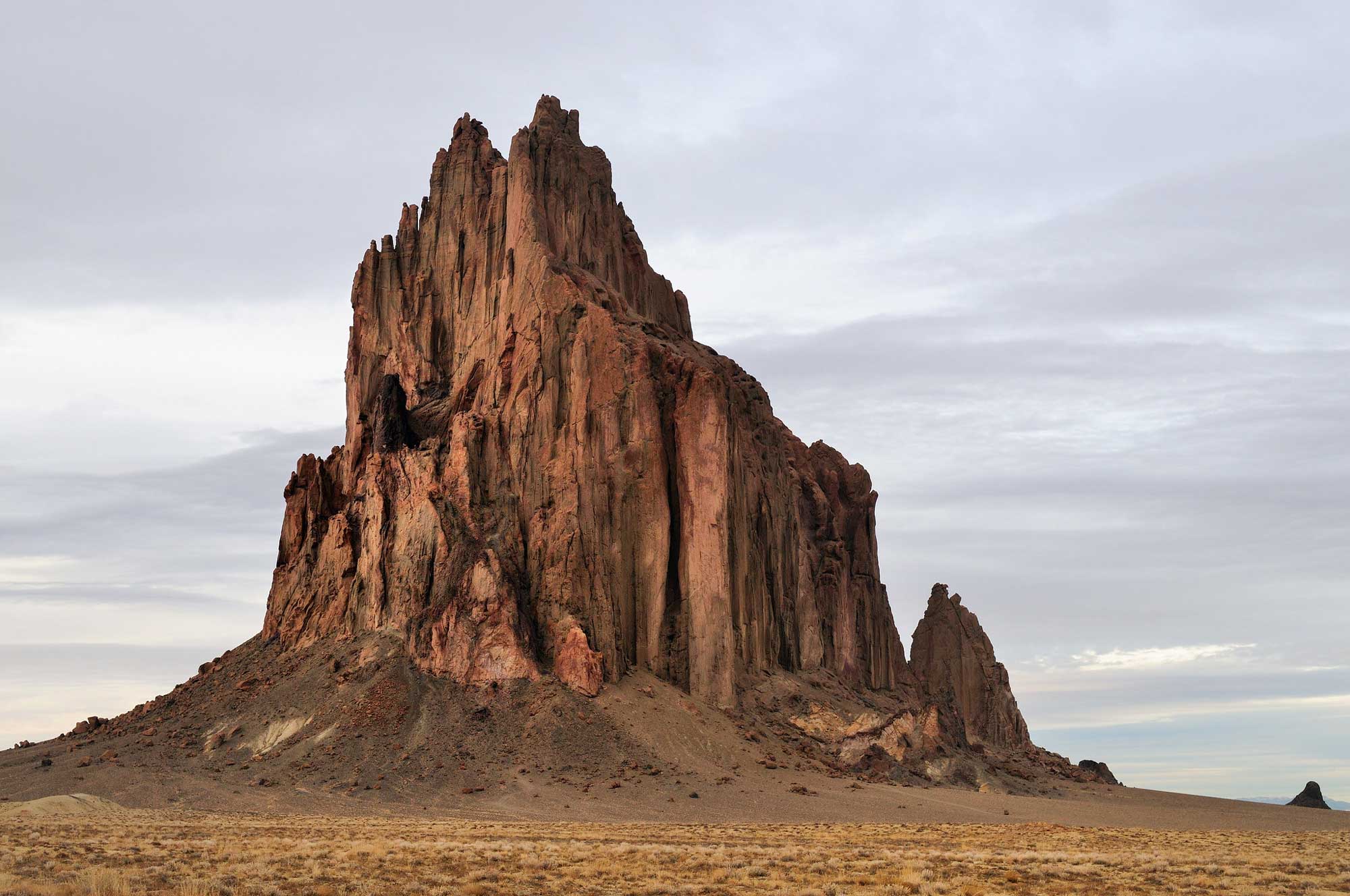
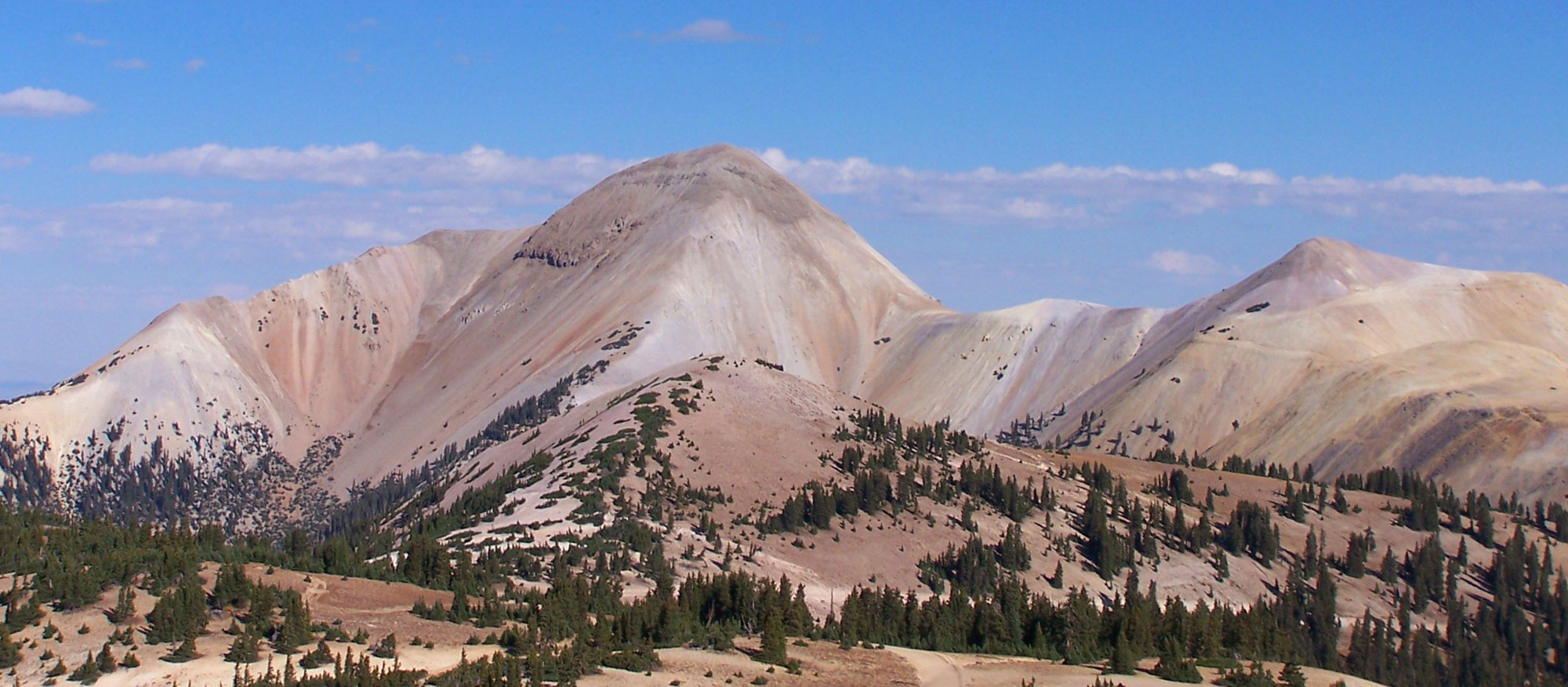
Shiprock, a volcanic monadnock in San Juan County, New Mexico, rises roughly 483 meters (1583 feet) above the desert plain. Shiprock is part of the San Juan volcanic field and dates to the Oligocene (about 27 million years ago). Photograph by "Cathy" (Flickr; Creative Commons Attribution-NonCommerical 2.0 Generic license).
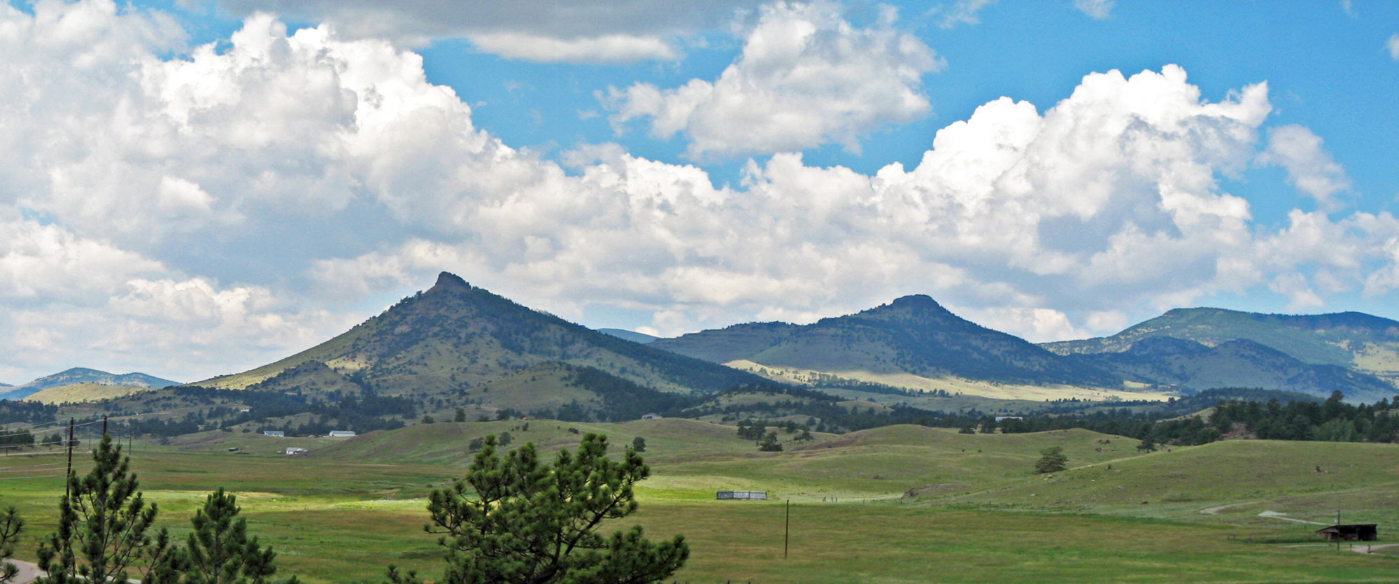
Peaks of the Eocene Guffey Volcanic Center, Park County, Colorado. Ash, lahars, and mudflows produced by volcanoes of the Guffey Volcanic Center, part of the Thirty-nine Mile Volcanic Field, are responsible for the preservation of fossils at the Florissant Fossils Beds. Photo by James St. John (flickr, Creative Commons Attribution 2.0 Generic license, image resized).
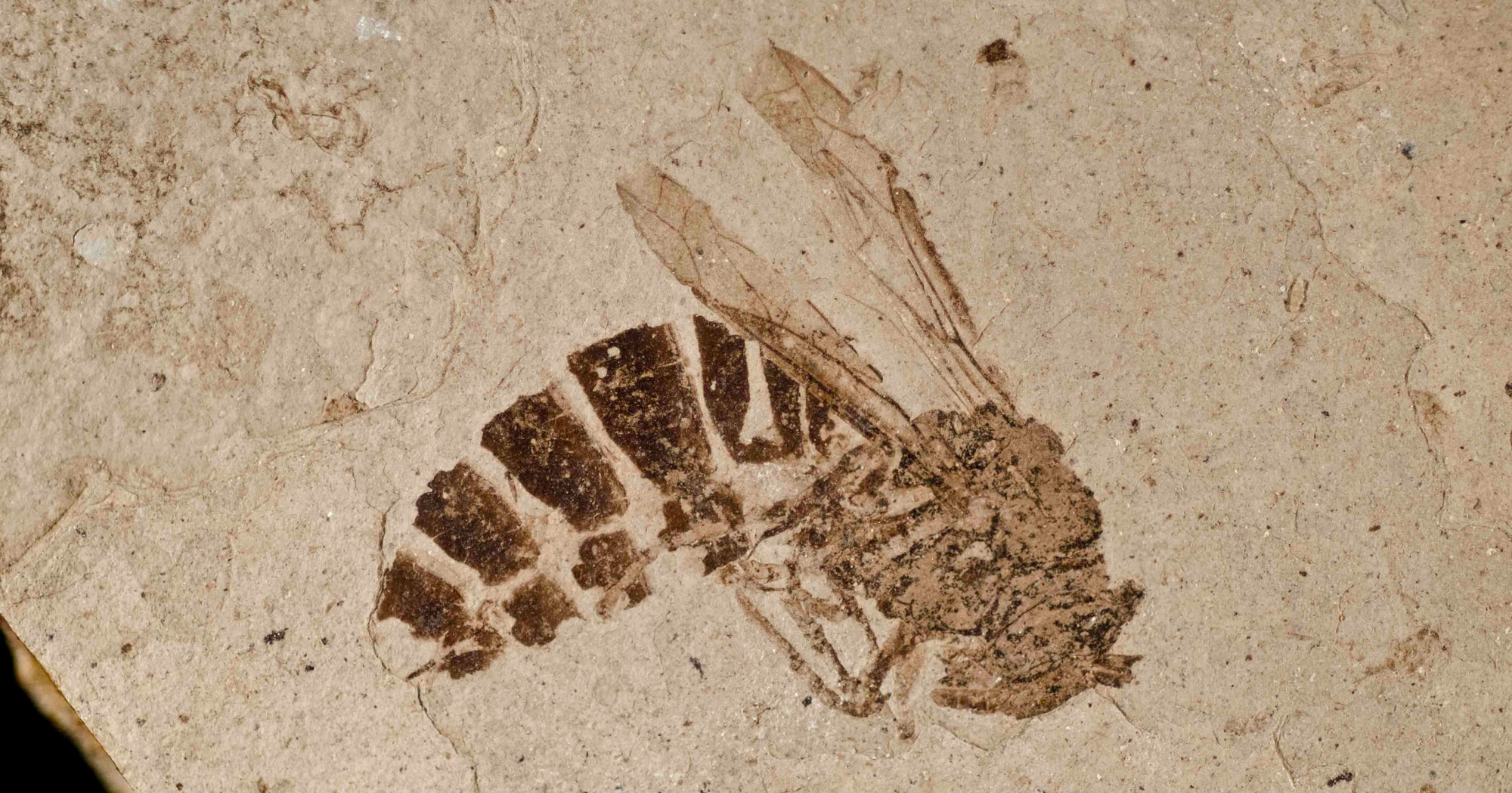
Fossil yellow jacket (Palaeovespa) the late Eocene Florissant Fossil Beds, Teller County, Colorado. Ash, lahars, and mudflows produced by volcanoes of the Guffey Volcanic Center (part of the Thirty-nine Mile Volcanic Field) are responsible for the preservation of fossils at the Florissant Fossils Beds. Photo by National Park Service/NPS (public domain).
Mt. Belknap, Marysvale Volcanic Field, Utah. Photo by Bryant Olsen (flickr, Creative Commons Attribution-NonCommercial 2.0 Generic license, image cropped and resized).
Neogene (23 to 2.6 million years ago)
By the Neogene, the Farallon plate lay shallowly under the North American plate for hundreds of kilometers eastward of the West Coast. Now situated more fully beneath what are now the south-central, southwestern, and northwest-central states, this extra layer of crust caused uplift and extension of the region, as the added thickness of buoyant rock (relative to the mantle) caused the entire area to rise isostatically. The Farallon plate was subjected to increasing temperatures as it subducted, causing it to expand. As heat dissipated to the overlying North American plate, that rock expanded as well. Finally, the high temperatures in the upper mantle caused the Farallon plate to melt, and the resulting magma was injected into the North American plate, destabilizing it. These processes, along with the complex crustal movements taking place along the San Andreas fault, caused the surface of the North American plate to pull apart and fault into the mountainous blocks of the huge Basin and Range province that stretches from Idaho, Nevada, and Utah into California, Arizona, New Mexico, and Texas.
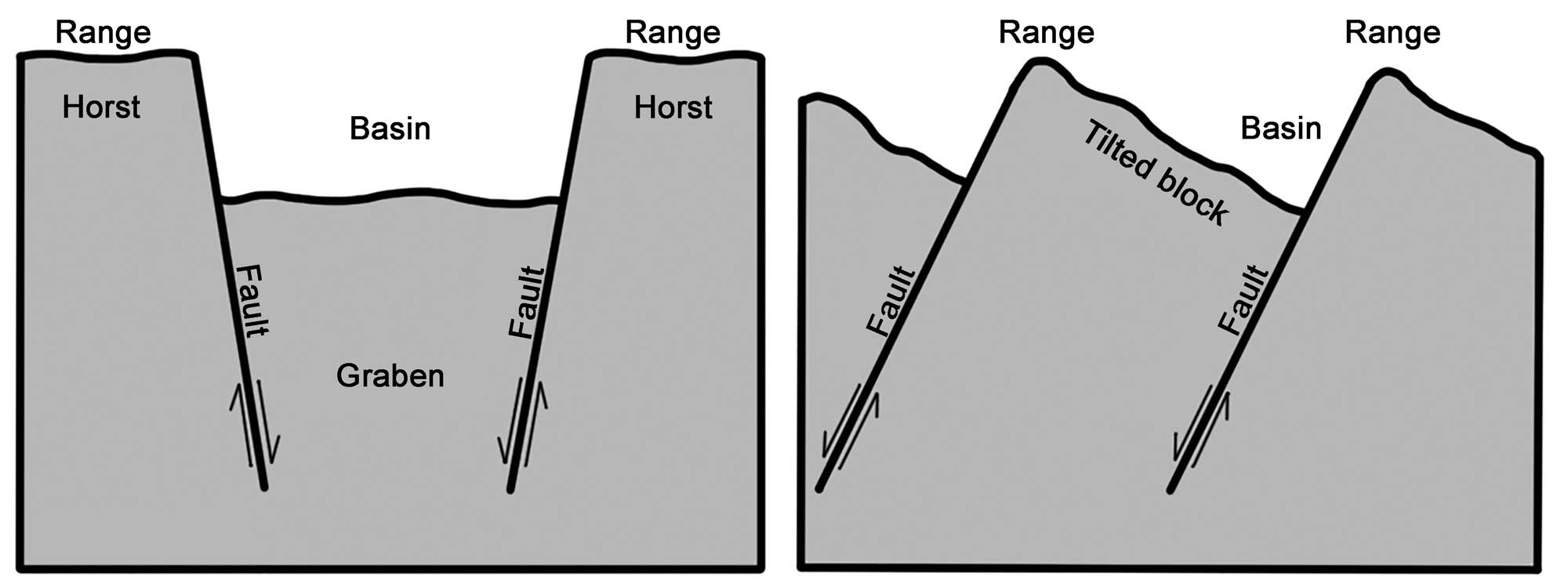
Alternating basins and ranges were formed during the past 17 million years by gradual movement along faults. Arrows indicate the relative movement of rocks on either side of a fault. Image modified from original by Wade Greenberg-Brand, in turn adapted from an image by the USGS (public domain).
In the late Miocene, around eight million years ago, epeirogenic uplift (resulting from upwelling mantle heat pushing the crust upwards) began. The uplift raised not just the mountains but also the base elevation of the entire region to its current level. This process raised the Rocky Mountains and Colorado Plateau to their current “mile-high” elevation, initiating the downcutting of the Grand Canyon in Arizona. The modern direction of the Colorado River’s flow toward the Gulf of California was established about six million years ago, at which time the river began to widen and deepen the canyon we know today.
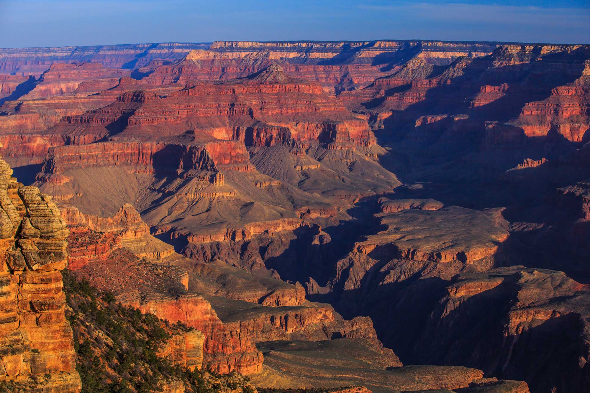
Grand Canyon, Arizona. Photo by Murray Foubister (Wikimedia Commons, Creative Commons Attribution-ShareAlike 2.0 Generic license, image resized).
Volcanic activity continued in the Southwest throughout the Neogene and extending in the Pleistocene. The Raton Volcanic Field in the Raton Basin formed about 9 million years ago (during the late Miocene) and erupted in several phases, ending about 30,000 years ago. Some well-known landmarks in the region were formed by the activity of this volcanic field, including the Capulin Volcano in northern New Mexico and Fishers Peak near Trinidad, Colorado.
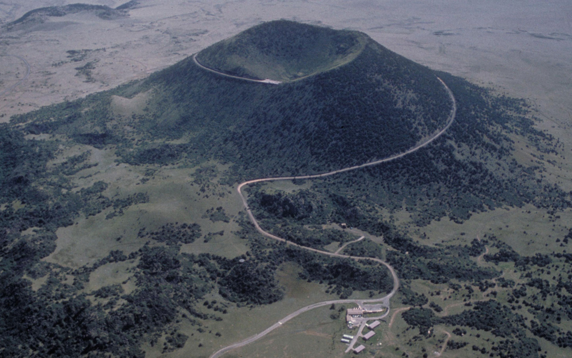
Capulin Volcano, a volcano that formed in the Southwest during the Pleistocene, about 60,000 years ago. Photo by National Park Service/NPS (public domain).
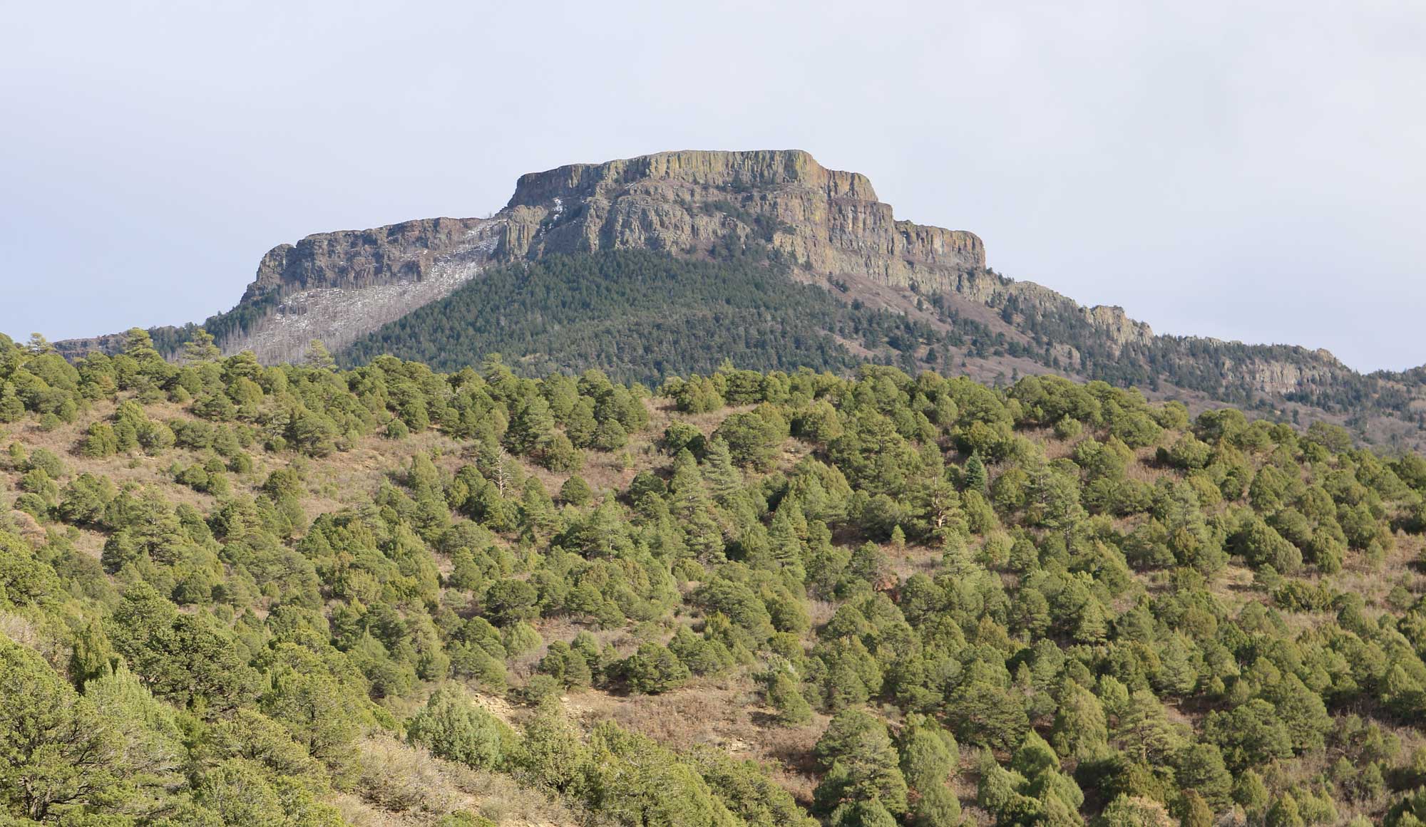
Fishers Peak, Las Animas County, Colorado. Photo by Jeffery Beall (Wikimedia Commons, Creative Commons Attribution 4.0 International license, image resized).
Quaternary (2.6 million to 12,000 years ago)
At the start of the Quaternary period, approximately 2.5 million years ago, continental ice sheets began to form in northernmost Canada. Throughout this period, the northern half of North America has been periodically covered by continental glaciers that originated in northern Canada. The Quaternary period is divided into two epochs: the Pleistocene and Holocene. During the Pleistocene, ice sheets advanced south and retreated north several dozen times, reaching their last maximum extent 25,000–18,000 years ago. The Holocene epoch is the most recent (and current) period of retreat, and is referred to as an interglacial interval. The beginning of the Holocene is considered to be 11,700 years ago, or about 9700 BCE.
The Pleistocene ice sheets did not extend into the Southwest. At their greatest extent in the western U.S., continental ice sheets reached into Washington, Idaho, Montana, and the Dakotas. However, local alpine glaciers covered the highest parts of the Rocky Mountains as far south as northern New Mexico. These glaciers carved U-shaped valleys with steep headwalls (cirques) and sharp drainage divides (arêtes). They also left unsorted deposits of glacial till in lateral moraines along the sides of valley walls, and in terminal and recessional moraines marking both the farthest extent of the ice and the places where the ice front paused during retreat. A small number of glaciers still occur in the Colorado Rockies today. These glaciers exist only because they have formed in sheltered areas where they are fed by drifting snow and avalanches and are protected from heat and sun that could fully melt them. As the climate warms, they are likely to eventually disappear.
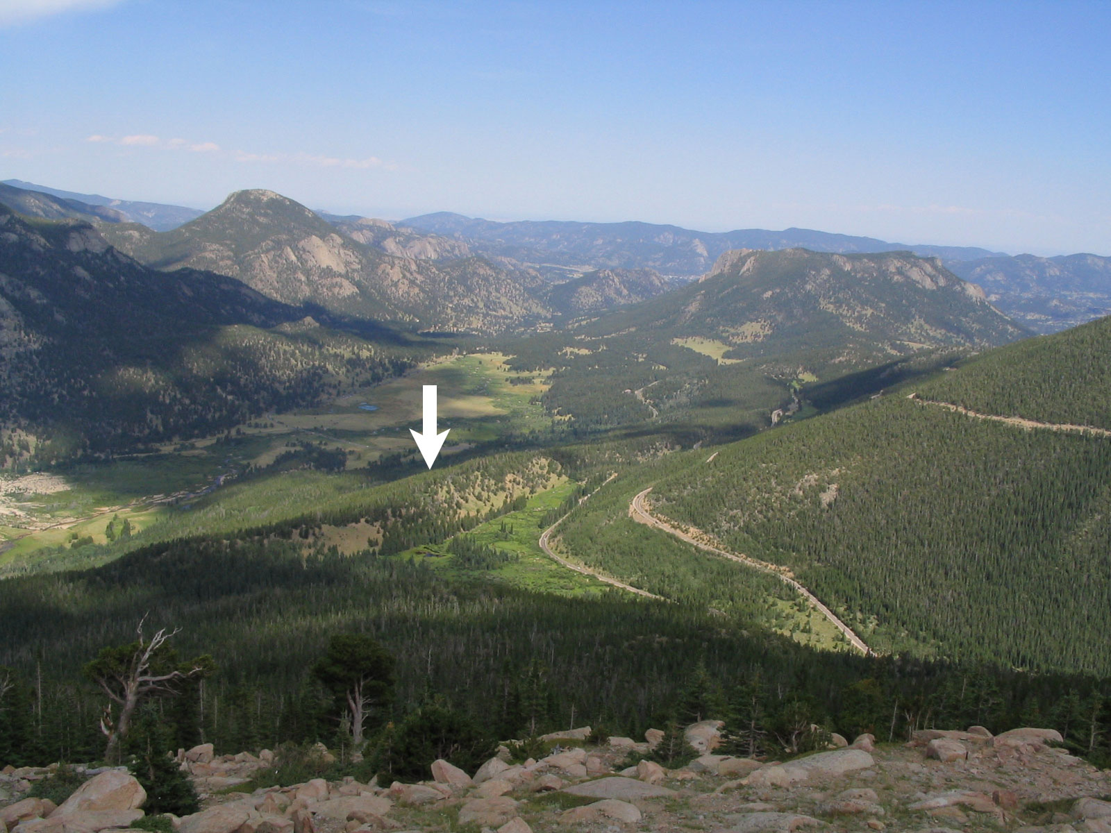
Lateral moraine forming a ridge (arrow), left by an alpine glacier at West Horseshoe Park, Rocky Mountain National Park, Colorado. Photo by Ken Lund (flickr, Creative Commons Attribution-ShareAlike 2.0 Generic license, image resized and labeled).
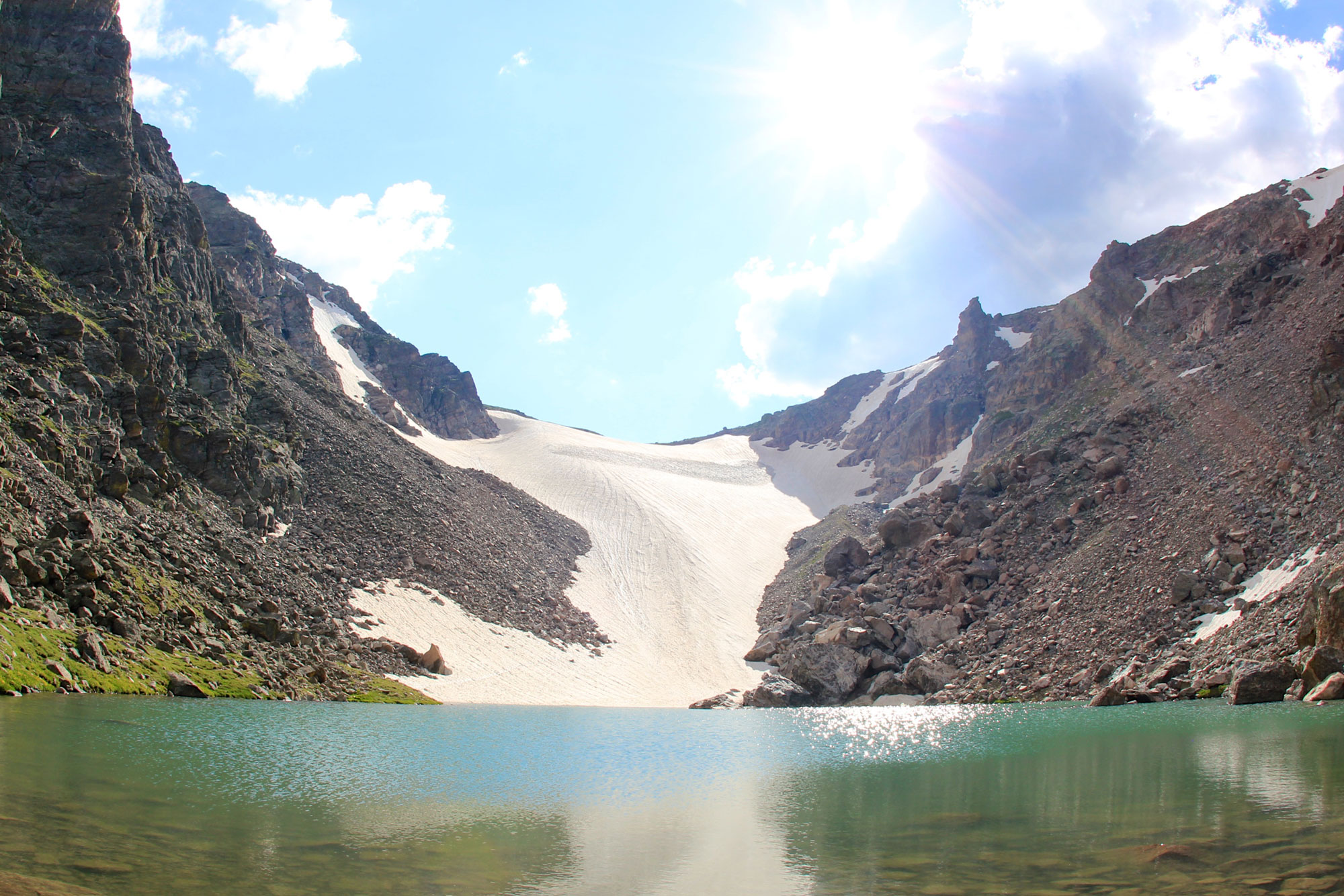
Andrews Glacier, Rocky Mountain National Park, Colorado. Photo by daveynin (flickr, Creative Commons Attribution 2.0 Generic license, image resized).
Glacial lakes formed in low areas between or in front of glaciers, and also during times between glacial advances. One such lake, Lake Bonneville in Utah, was the precursor of today’s Great Salt Lake.
The Quaternary period has been dominated by the advance and retreat of continental ice sheets and alpine glaciers; glacial periods alternate with warm interglacial periods. While the “ice age” continues today, the Earth is in an interglacial stage, since the ice sheets have retreated for now. The glacial-interglacial cycling of ice ages indicates that the world will return to a glacial stage in the future, unless the impacts of human-induced climate change radically shift these natural cycles.
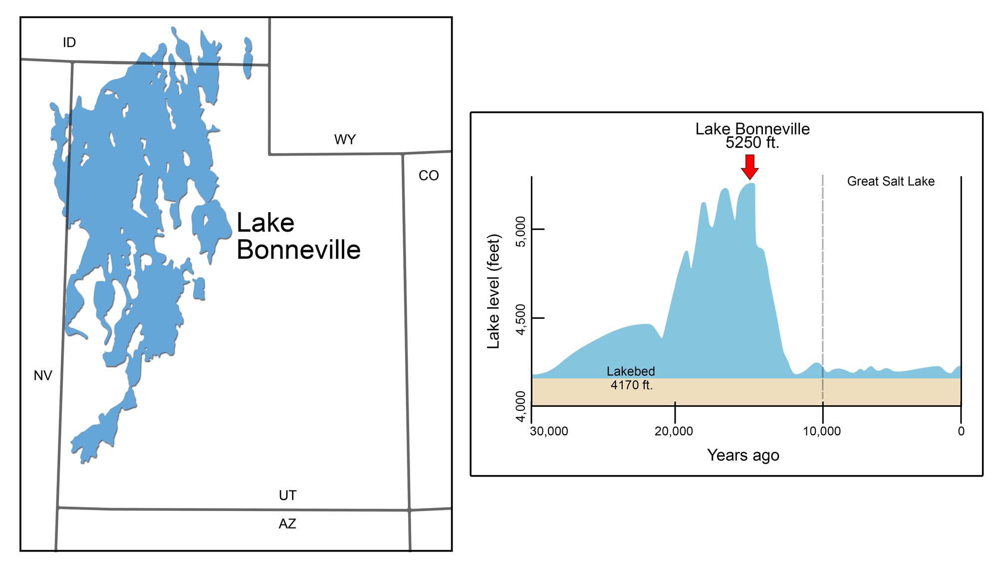
Pleistocene Lake Bonneville. Left: Lake Bonneville's maximal extent during the Pleistocene. Right: Graph of the lake's changing level over time. Modified from illustrations by Wade Greenberg-Brand originally published in The Teacher-Friendly Guide to the Earth Science of the Southwestern US.
Resources
Resources from the Paleontological Research Institution
Earth@Home: Here on Earth: Introduction to Plate Tectonics: https://earthathome.org/hoe/plate-tectonics
Earth@Home: Quick Guides and FAQ: How did the Grand Canyon Form?: https://earthathome.org/quick-faqs/how-did-the-grand-canyon-form/