

Page Snapshot: Introduction to Earth hazards in the western United States.
Contents
Topics covered on this page: Plate tectonics; Earthquakes; Tsunamis; Landslides; Volcanoes; Climate change; Resources.
Credits: Most of the text on this page comes from "Earth Hazards of the Western US" by Wendy E. Van Norden, Alexandra Moore, and Gary Lewis, chapter 10 in The Teacher-Friendly Guide to the Earth Science of the Western US, edited by Mark D. Lucas, Robert M. Ross, and Andrielle N. Swaby (published in 2014 by the Paleontological Research Institution). The book was adapted for the web by Elizabeth J. Hermsen and Jonathan R. Hendricks in 2021–2022. Changes include formatting and revisions to the text and images. Credits for individual images are given in figure captions.
Updates: Page last updated June 30, 2022.
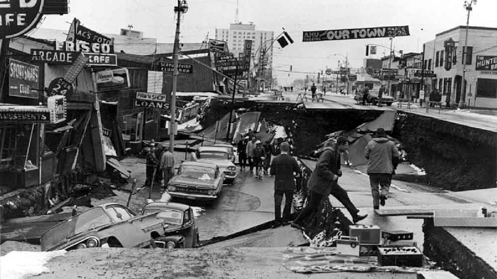
Image above: Downtown Anchorage, Alaska following the 1964 Alaska Earthquake. Photograph by the U.S. Army (Wikimedia Commons; public domain).

Introduction: Role of plate tectonics in the western U.S.
Natural hazards are events that result from natural processes and that have significant impacts on human beings. Extreme weather conditions or geologic activity can cause substantial short-term or long-term changes to our environment. These changes can influence crops, homes, infrastructure, and the atmosphere. The 4.6-billion-year-old Earth has experienced many of these natural changes, and it has always adjusted accordingly.
The Western United States is located at the junction of three tectonic plates: the Pacific, the Juan de Fuca, and the North American.
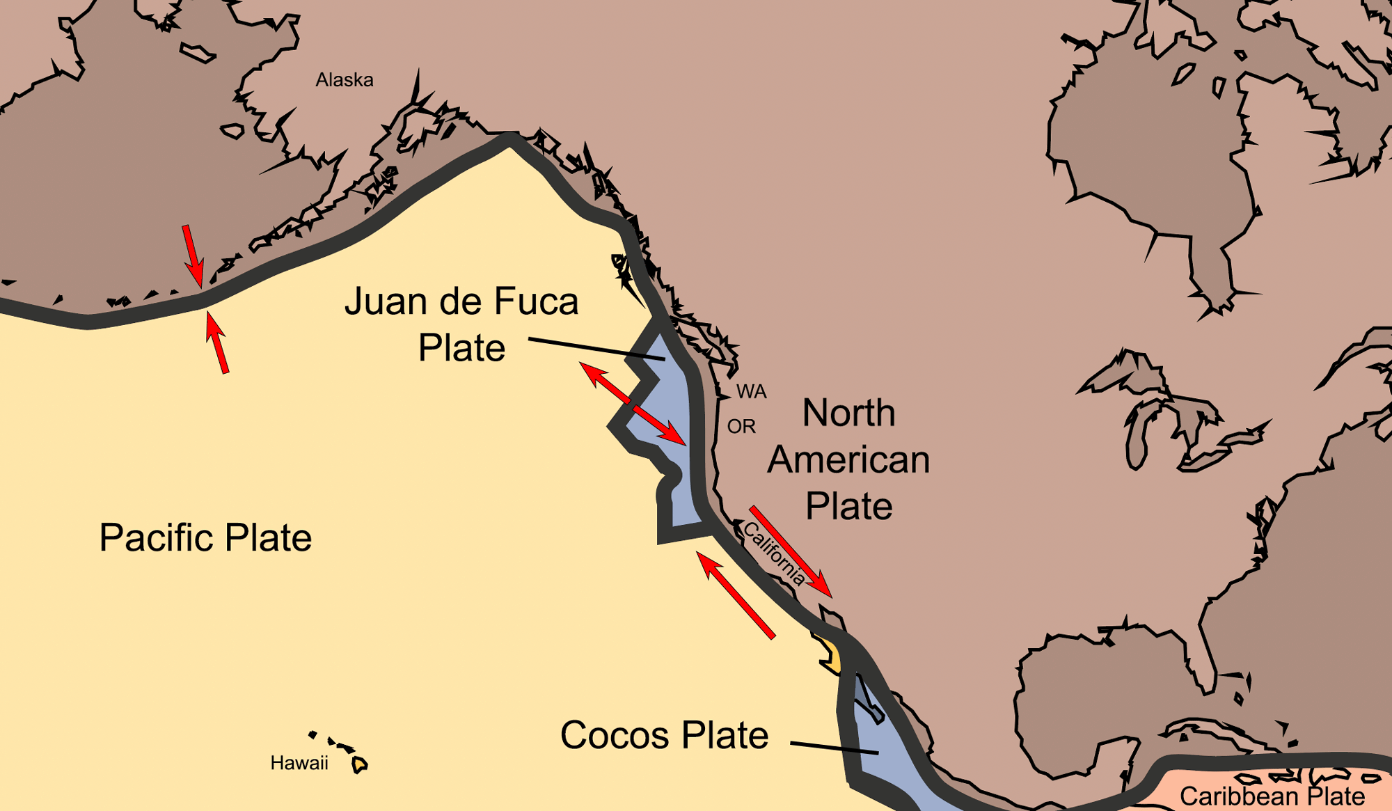
The tectonic plates that contribute to Earth hazards in the western United States include the Pacific Plate, Juan de Fuca Plate, and the North American Plate. Map by Jonathan R. Hendricks for the Earth@Home project derived from map by the USGS (Wikimedia Commons; public domain).
The movement of these plates, even though it occurs on the scale of millimeters per year, makes the Western U.S. a dynamic landscape. The dramatic result is a dizzying assortment of natural hazards such as earthquakes, tsunamis, landslides, and volcanoes. The Pacific plate is subducting under Alaska, creating the volcanoes of the Aleutian Islands. The Juan de Fuca plate is subducting under Washington, Oregon, and Northern California, creating the Cascade volcanoes, and the Pacific plate is grinding past the North American plate along the famous San Andreas Fault. At the same time, the Basin and Range province, which includes nearly the entire state of Nevada, is being stretched and faulted by plate movement. While the motion of all tectonic plates can cause earthquakes, the movement of a subducting plate can cause the world’s largest earthquakes and tsunamis. Tectonic activity lifts the landscape high above sea level, and because uplifted land is subject to the force of gravity, mass wasting processes such as landslides are the inevitable result. These events can be triggered by rain, earthquakes, and coastal or river erosion. The Western U.S. contains rugged landscapes and breathtaking vistas, but with that beauty comes a cost: there are more earthquakes, tsunamis, landslides, and volcanoes in the Western states than in all the other states combined.
All tectonic plates move relative to other plates, and the Pacific plate is moving at a rate of roughly 50 millimeters/year (2 inches/year) relative to the North American plate. Most, but not all, of this motion occurs along the San Andreas Fault. The Sierra Nevada, whose granite plutons were created by the subduction of an ancient plate known as the Farallon plate, are located on the North American plate, but they are being pulled along by the Pacific plate. The Juan de Fuca plate, which is all that remains of the Farallon, is moving toward North America at an average rate of 36 millimeters/year (1.4 inches/year), creating the Cascade Range’s volcanoes.
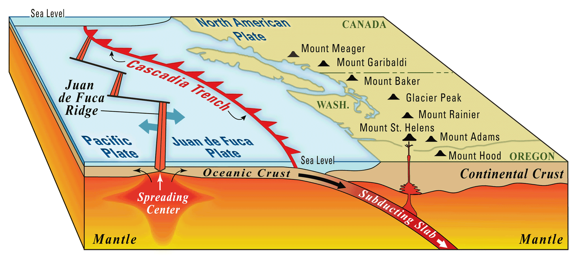
Original caption: "Block diagram showing subduction of the Juan de Fuca Plate beneath the North American Plate along the Cascadia Trench, which is the western edge of the Cascadia subduction zone. Oceanic crust forms by eruptions along the Juan de Fuca Ridge. As the Juan de Fuca Plate drifts eastward, it cools, becomes more dense, and eventually dives under the less dense North American Plate at the Cascadia Trench. Water released from the subducting slab causes the overlying mantle to partially melt, forming magma that sustains the Cascade Range of volcanoes (black triangles)." Image by the USGS (public domain).
As the Pacific plate continues to move northwest, it is causing the Basin and Range to pull apart. As a result, Nevada is full of sinking valleys and tilted mountains, and is growing wider in the process.
Convergent plate boundaries
Where two plates collide, the denser plate (usually oceanic) subducts under the lighter one (either a younger oceanic plate or a continental plate) and creates a subduction zone. Subduction zones produce the largest and deepest earthquakes in the world. The water in the subducting plate is carried deep into the mantle and causes the melting of the overlying mantle rock. The resulting magma is hot and buoyant, so it rises to the surface and creates volcanoes. In the Western U.S., the Aleutian Island Arc and the Cascade volcanoes provide surface evidence of convergent boundaries.
Divergent Boundaries
Divergent plate boundaries exist where tectonic plates are under tension—essentially being pulled apart. This tension leads to the upwelling of magma, which forces its way through the separating crust onto the surface. In oceanic settings, such as the Juan de Fuca Ridge, new oceanic crust is created, and shallow, minor earthquakes occur. In continental settings, such as the Basin and Range of Nevada, the result of the tension is faulting and shallow earthquakes.
As the faults pull apart and thin the crust, the decrease in overlying pressure can result in the formation of basaltic magma, which, in turn, can lead to the formation of small volcanoes called cinder cones. The faulting also creates the down-dropped basins and tilted mountain ranges of the Basin and Range.
Transform Boundaries
Transform boundaries exist where adjacent tectonic plates are moving alongside each other, causing a transform fault to develop. Most transform fault boundaries can be found in the ocean, where they connect divergent boundaries. One exception is the San Andreas Fault, which is mainly located on land. It separates the small divergent boundaries in Mexico (between the mainland and the Baja Peninsula) from the Juan de Fuca Ridge, and runs through continental crust for the majority of its length. The San Andreas Fault produces earthquakes when the plates slip, but it can also create ridges parallel to the fault, as well as mountains and valleys when the fault changes direction.
Earthquakes
Earthquakes occur when a critical amount of stress is applied to the crust. According to the elastic rebound theory, rocks can bend elastically up to a point, until they finally break. The rocks then snap apart, releasing energy in the form of seismic waves. The plane defined by the rupture is known as a fault, and the rock layers become offset along it.
"Elastic Rebound Theory" by Harmony Square (YouTube).
The most notable earthquakes that have impacted the western United States are listed below.
| Date | Location | Mw |
|---|---|---|
| March 28, 1964 | Prince William Sound, AK | M9.2 |
| January 26, 1700 | Cascadia subduction zone, OR, WA, CA | M9.0 |
| February 4, 1965 | Rat Islands, AK | M8.7 |
| March 9, 1957 | Andreanof Islands, AK | M8.6 |
| November 10, 1938 | Shumagin Islands, AK | M8.2 |
| April 1, 1946 | Unimak Island, AK | M8.1 |
| September 11, 1899 | Yakutat Bay, AK | M8.0 |
| November 3, 2002 | Denali Fault, AK | M7.9 |
| January 9, 1857 | Fort Tejon, CA | M7.9 |
| April 18, 1906 | San Francisco, CA | M7.8 |
| February 24, 1892 | Imperial Valley, CA | M7.2 |
| June 28, 1992 | Landers, CA | M7.3 |
| October 17, 1989 | Loma Prieta, CA | M6.9 |
| January 17, 1994 | Northridge, CA | M6.7 |
San Andreas Fault, California
Small earthquakes are common in the tectonically active western United States and usually don't cause damage. Large earthquakes, however, can have devastating impacts on buildings, infrastructure, and human life. One of the most famous earthquakes in the western U.S. occurred on April 18, 1906 at about 5:12 AM. The earthquake caused damage to San Francisco, but most of the destruction was caused by fires that were triggered by the earthquake.
Restored film of busy Market Street in San Francisco captured four days before the 1906 San Francisco Earthquake. "San Francisco 1906 (New Version) in Color [60fps, Remastered] w/added sound" by NASS (YouTube).
Restored film captured following the 1906 San Francisco Earthquake. "Rediscovered film takes a trip through San Francisco ruins" by PBS NewsHour (YouTube).
In the case of the 1906 San Francisco Earthquake, the rupturing occurred along a nearly 300 mile stretch of the famous San Andreas Fault. The San Andreas Fault, a 1304-kilometer (810-mile) long plate boundary, is not a single fault but a fault zone because it does not move all at once. Instead, great lengths of the fault rupture while other sections remain locked. Some sections do neither, but instead creep along without generating significant earthquakes.
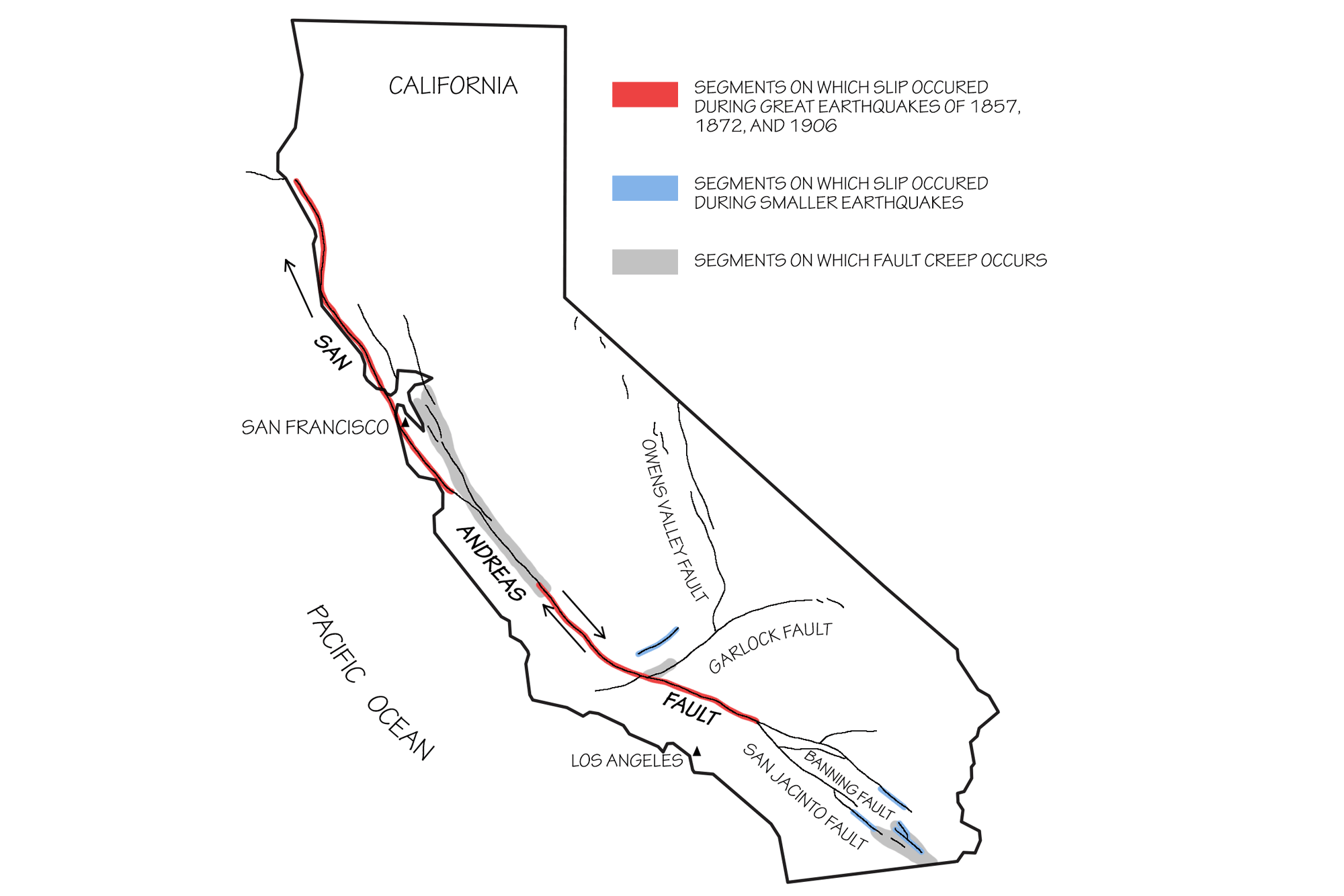
San Andreas Fault and associated seismic zones. Adapted from original image by the USGS (public domain).
An excellent place to see offset along the San Andreas Fault is at Point Reyes National Seashore, which is located just northwest of San Francisco, California. Point Reyes is on the Pacific plate, which is moving northwest relative to the North American Plate. The position of the San Andreas Fault is represented by Tomales Bay and the Olema Valley.
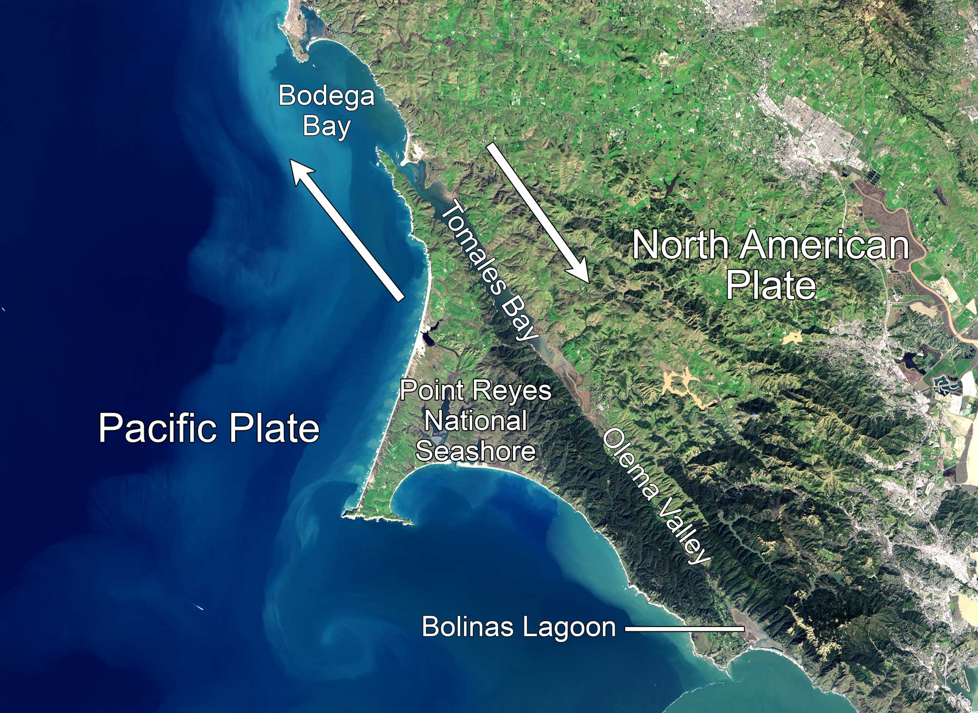
Aerial photo of the Central California coast in the area of Point Reyes and Bodega Bay, which are north of San Francisco. The San Andreas Fault is clearly visible; it runs through the Olema Valley and Tomales Bay, continuing northwest through Bodega Bay. Source: NASA Earth Observatory image by Jesse Allen (NASA Earth Observatory, used following NASA's image use policy, image cropped and labels added).
The Earthquake Trail at Point Reyes National Seashore, which begins at the Bear Valley Visitor Center, follows the trace of the 1906 San Francisco earthquake to a picket fence along the fault. The fence was once connected, but today it is separated by a 6-meter (20-foot) gap.
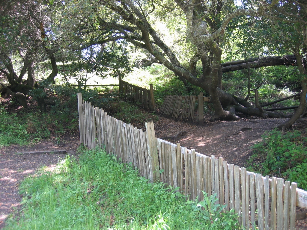
A fence near Point Reyes, California that was broken and displaced by the 1906 San Francisco Earthquake. The San Andreas Fault runs perpendicular between the two sections of fence. Image by Dave Schumaker (Flickr; Creative Commons Attribution-NonCommercial-NoDerivs 2.0 Generic license).
On October 17, 1989, a rupture along the San Andreas Fault resulted in the M6.9 Loma Prieta earthquake, which had an epicenter near Santa Cruz, California. Over 60 deaths and significant damage resulted from this earthquake, including the collapse of a portion of a double-deck freeway in Oakland.
"On Shaky Ground: The 1989 San Francisco Earthquake | Retro Report" by The New York Times (YouTube).
Southern California is particularly susceptible to a devastating earthquake, in part because it has been so long since a major or great quake has occurred. Over 150 years ago, the M7.9 Fort Tejon earthquake caused 360 kilometers (225 miles) of the San Andreas Fault to rupture. The southernmost section of the San Andreas has not ruptured in the last 300 years. In response to this growing hazard, geologists have created a “Great ShakeOut” earthquake scenario. This scenario models the effects of a M7.8 earthquake on a 300-kilometer (180-mile) rupture from Bombay Beach at the Salton Sea to Lake Hughes north of Los Angeles. Both the Fort Tejon segment and the southernmost segment of the San Andreas fault zone are considered at risk for a major earthquake at any time, and either one could generate an earthquake that would wreak havoc on the lives of the 23 million inhabitants of Southern California. Earthquake preparedness drills based on this scenario have been taking place in southern California since 2008, and they attract millions of participants every year.
Cascadia
Although Washington and Oregon have not experienced many major earthquakes in the recent past, they are located above the Cascadia subduction zone.
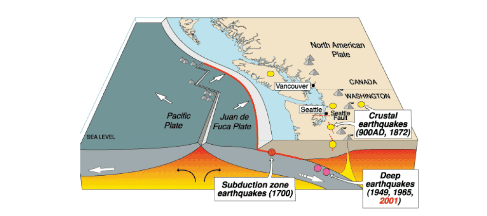
The Cascadia subduction zone and its related seismic occurrences. Image by the USGS (public domain).
Since the Cascadia subduction zone is as large as the subduction zone that created the 2004 Sumatra Earthquake and subsequent tsunami, it could potentially generate an M8.0 or higher earthquake. It did just that in the year 1700, when the tip of the overriding plate (North America), which had been buckling upward under the stress of the ongoing collision, flattened out when the plates suddenly slipped past one another. The resulting earthquake caused the submergence of coastal land and the drowning of cedar forests along 965 kilometers (600 miles) of California, Oregon, Washington, and southern British Columbia. Places formerly above sea level dropped down, pushing enormous waves all the way across the ocean, and creating a tsunami that struck Japan. Written records of the damage to Japan’s coastal villages allow us to pinpoint the day and time this earthquake occurred—the evening of January 26, 1700.
If the Cascadia subduction zone were to partially rupture today, it could create an M8.2 earthquake, and if it were to rupture along its entire length, it could generate an M9.0 earthquake. Geologists have recently forecast a 37% chance of an M8.2 or higher event within 50 years, and a 10–15% chance of an event of M9.0 or higher. Unlike Alaska, which had a population of only 763,000 in 2013, Washington and Oregon have a combined population of over 10 million people, most of whom live near the coast. Needless to say, Cascadia inhabitants would benefit greatly by preparing for a large earthquake and tsunami.
Alaska
Alaska has more earthquakes than all of the other states combined. California is second, with only about half as many as Alaska. The following table lists the number of earthquakes of M3.5 or greater from 1974 to 2003, according to the USGS Earthquake Hazards Program.
| State | No. Earthquakes |
|---|---|
| Alaska | 9020 |
| California | 1545 |
| Nevada | 513 |
| Hawaii | 200 |
| Washington | 60 |
| Oregon | 17 |
Number of M3+ earthquakes in each western state and Hawaii between 2010 and 2015. Data from the USGS Earthquake Hazards Program.
The largest earthquake in US history was the 1964 Alaskan Earthquake, which had an Mw of 9.2. The earthquake lasted over 4 minutes and the resulting tsunami caused over 130 deaths. Many buildings in Anchorage were destroyed (see photograph at the top of this page). The video below provides an overview of the causes and consequences of this devastating earthquake.
"1964 Quake: The Great Alaska Earthquake" by USGS (YouTube).
Tsunamis
The tallest wave ever recorded occurred in Lituya Bay, located along the Alaskan Panhandle. On the night of July 9, 1958, a M8.5 earthquake initiated a landslide. Thirty million cubic meters (forty million cubic yards) of rock plunged into the bay, creating a local tsunami that destroyed all trees and vegetation up to a height of 524 meters (1720 feet) above the bay.
"Surviving Most Extreme Mega Tsunami in Modern History - True Story" by The Infographics Show (YouTube).
'Mega Tsunami - Evidence of Destruction" by BBC Nature (YouTube).
The shape of a bay or harbor can accentuate the effects of a tsunami, funneling the wave’s energy inland—such was the case in Crescent City, California after the Great Alaskan Earthquake of 1964. The earthquake created a tsunami that arrived at Crescent City four hours later. Although the first three waves did only minor damage, the fourth wave, approximately 6 meters (20 feet) tall, inundated the town, killing 12 residents and injuring over 100, and destroying hundreds of buildings. Forty-seven years later, Crescent City was once again struck by a tsunami, this time from the 2011 M9.0 Tohoku-Oki Japan earthquake. Fortunately, there was only one death because at-risk areas of the city were evacuated before the arrival of the first wave.
"Crescent City Takes Tsunami Toll" by KSBW Action News 8 (YouTube).
The West Coast of North America is prone to tsunamis because of the seismically active “Ring of Fire” around the Pacific Ocean. The National Oceanic and Atmospheric Association’s (NOAA’s) Pacific Tsunami Warning Center has created a tsunami warning system based upon earthquake data and real-time tsunami detectors in the deep ocean. If a tsunami is generated at a distance, residents of coastal communities can be warned so that they can follow established tsunami evacuation routes to high ground.
If, however, a tsunami is generated just offshore, there is not enough time for a warning, as was the case for coastal Japan with the 2011 M9.0 earthquake and associated tsunami.
The Japan 2011 and Alaskan 1964 earthquakes are good examples of megathrust earthquakes that are likely to create tsunamis. As one tectonic plate tries to subduct below another, the two plates can become stuck together. The pressure from the subducting plate builds up and deforms the overlying plate by causing it to buckle.
"Tsunamis Generated by Megathrust Earthquakes" by IRIS Earthquake Science (YouTube).
When the subducting plate finally moves, the overlying plate snaps back, uplifting the ocean and creating a tsunami. Not only could this happen along the Aleutian Island Arc’s trench, it could happen again along the Cascadia subduction zone. The location of the trench, just offshore of northern California, Oregon, and Washington, is likely to give coastal residents little time for evacuation.
Landslides
The generic term “landslide” refers to a wide range of mass wasting events during which rock material moves downhill. The rugged topography of the Western U.S. makes landslides a common problem. Landslides are usually triggered by high rainfall, but they can also be triggered by earthquakes, erosion, deforestation, groundwater pumping, and volcanic eruptions. Not all mass wasting events are rapid—slow land movement, known as soil creep, usually does not cause loss of life, but it can still destroy roads and buildings.
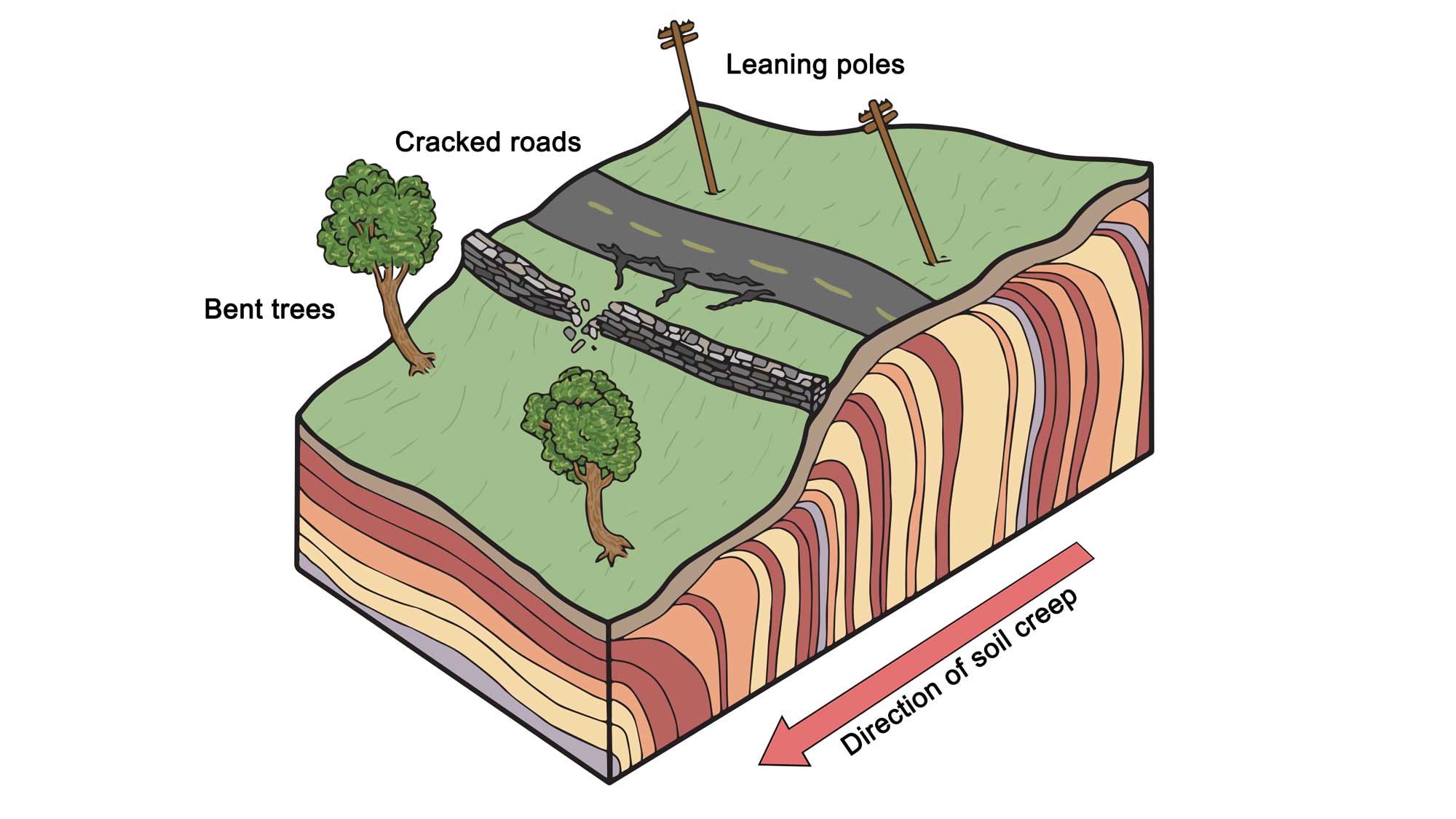
Some of the effects of soil creep on surface topography and structures. Note that subsurface colored layers are meant to depict movement, not stratigraphic layering of soil. Modifed from original by Wade Greenberg-Grand for the Earth@Home project.
Mud and debris flows are very fast landslides that are likely to kill anyone unfortunate enough to be caught in their path, as they can reach speeds that exceed 32 kph (20 mph).
The slowest kind of landslide is known as creep. When clay in the soil on a hillside absorbs water, it will expand, causing the soil to swell. As the clay dries and contracts, the particles settle slightly in the downhill direction. The process causes fences and telephone poles to lean downhill, while trees adjust by bending uphill (see image above).
The Arctic tundra of Alaska is experiencing an unusual form of creep called solifluction. During the summer, rain passes through the thawed upper layer of the soil but cannot penetrate the permafrost below. Instead, the water builds up against the impermeable permafrost. As a result, the water and soil move slowly downhill like thick porridge.
The Pacific Northwest is particularly prone to landslides because of its high levels of rainfall. The most damaging landslide in recent history was the March 22, 2014 Hazel mudslide in Oso, Washington. The Hazel landslide has been active for over 60 years, causing numerous smaller slides—the March 22 slide came from a high terrace made of a poorly cemented layer of glacial sand and gravel. After a period of extremely high rainfall, a section of the terrace collapsed into a fast-moving mudflow that engulfed 49 homes and took 41 lives. Incredibly, most of the homes were located across a river from the terrace, on a bluff nine meters (30 feet) above the river.
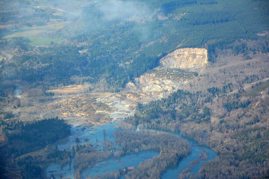
March 22, 2014 mudslide in Oso, Washington. Photograph by the Washington State Department of Transportation (Flickr; Creative Commons Attribution-NonCommercial-NoDerivs 2.0 Generic license).
The coastal erosion of hillsides often results in landslides. Portuguese Bend on California’s Palos Verdes Peninsula contains layers of rock that slope towards the ocean. Among these layers is bentonite, a very slippery clay layer. In the 1950s, houses were built on an area that soon started to slide once the city, in the process of road construction, had added material to the top of the slope. Although homeowners successfully sued the city for initiating the slide that destroyed their homes, they were also partially responsible since they added water to the slide by irrigating their lawns and using septic tanks. The land is still moving, and no houses can be built there.
Debris flows are a dangerous mixture of water, mud, rocks, trees, and other debris that move quickly down valleys. The flows can result from sudden rainstorms or snowmelt that creates flash floods. Areas that have experienced a recent wildfire are particularly vulnerable to debris flows, since there is no vegetation to hold the soil. El Niño climate conditions, which bring high precipitation, also increase the danger of debris flows.
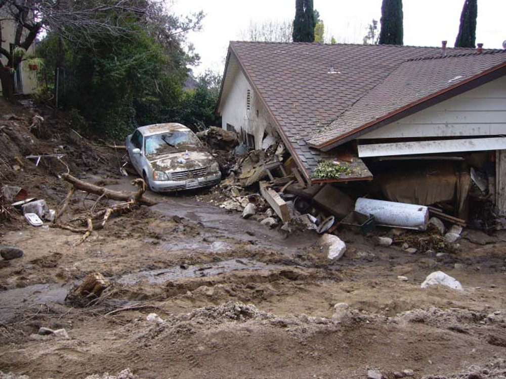
This debris fl ow occurred on February 6, 2010 in La Canada-Flintridge, California as a result of a flash flood generated in Mullally Canyon. Photograph by Susan Cannon, USGS (public domain).
In response to these dangerous slides, many communities have built debris basins across their canyons to protect houses downstream.
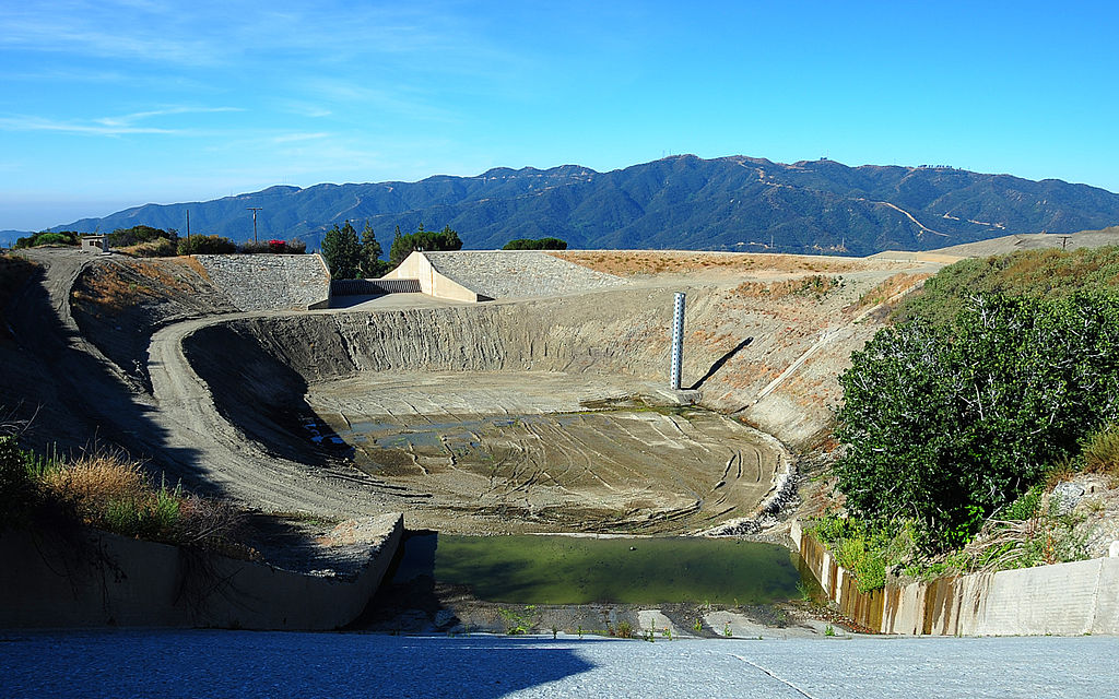
The Dunsmir Sediment (or, debris) Basin at La Cañada Flintridge, California. The debris basin in Los Angeles county is designed to capture the sediment, boulders, and other debris washed from the canyon during a storm. Photograph by FEMA (Wikimedia Commons; public domain).
The USGS and NOAA are in the process of instituting a flash flood and debris flow early-warning system.
One of the most dangerous kinds of debris flow is a lahar, which is composed of water and volcanic debris such as ash. An eruption is not necessary to trigger a lahar. A melting glacier, a debris dam being breached, or a crater lake’s walls collapsing can all send water and ash down the volcano at speeds up to 100 kph (60 mph). Mt. Rainier in Washington is considered the most dangerous volcano in the United States because of its proximity to high populations and its potential for lahars. The Puyallup River valley, directly downstream of the mountain, is built upon 500-year-old lahar deposits. The town of Orting is at the junction of two river valleys that descend from Mt. Rainer, making them capable of delivering a lahar. Since lahars are predicted to flow through the valley every 500 to 1000 years, the USGS has set up a lahar warning system to give people enough time to evacuate in the event of a lahar racing down the flanks of Mt. Rainier.
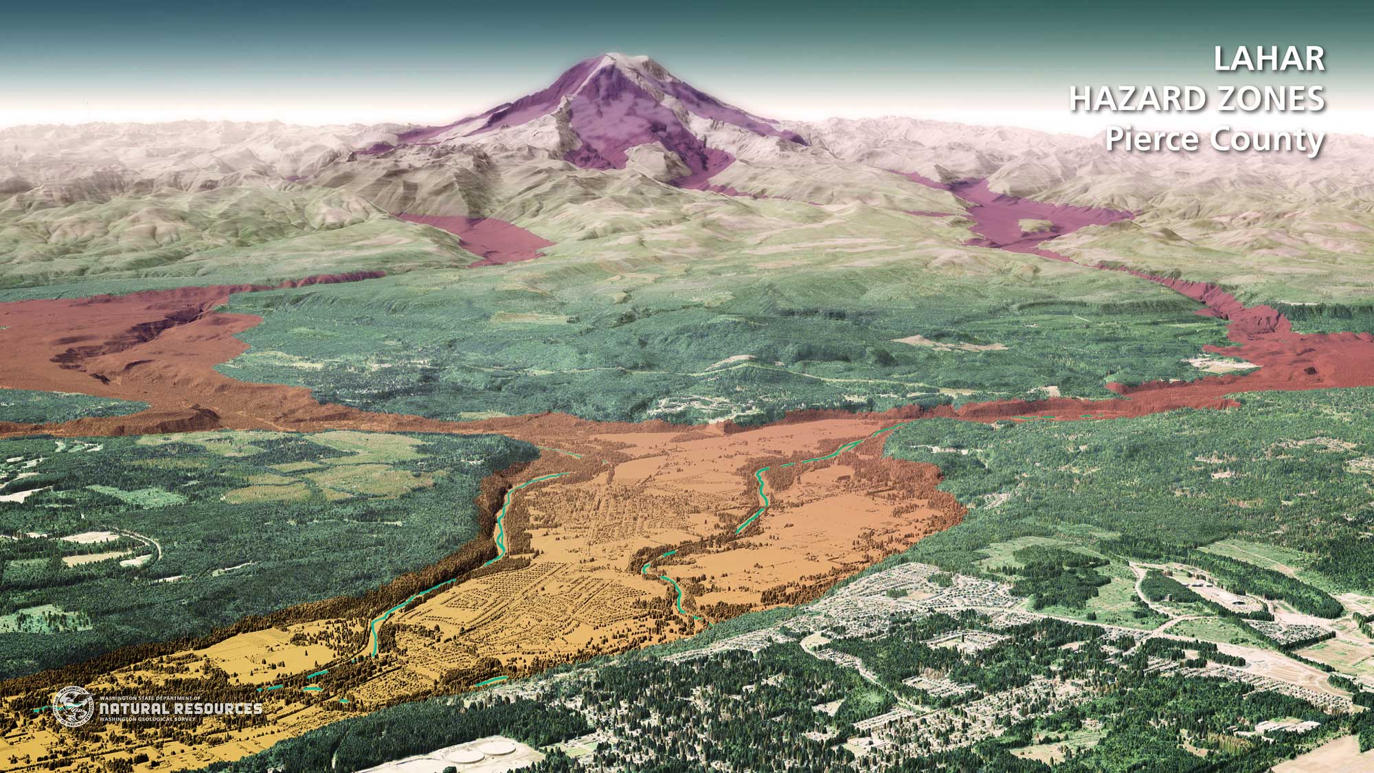
Lahar hazard zones in Piecre County, Washington. The community in the foreground is Orting. Image by the Washington DNR (Flickr; Creative Commons Attribution-ShareAlike 2.0 Generic license).
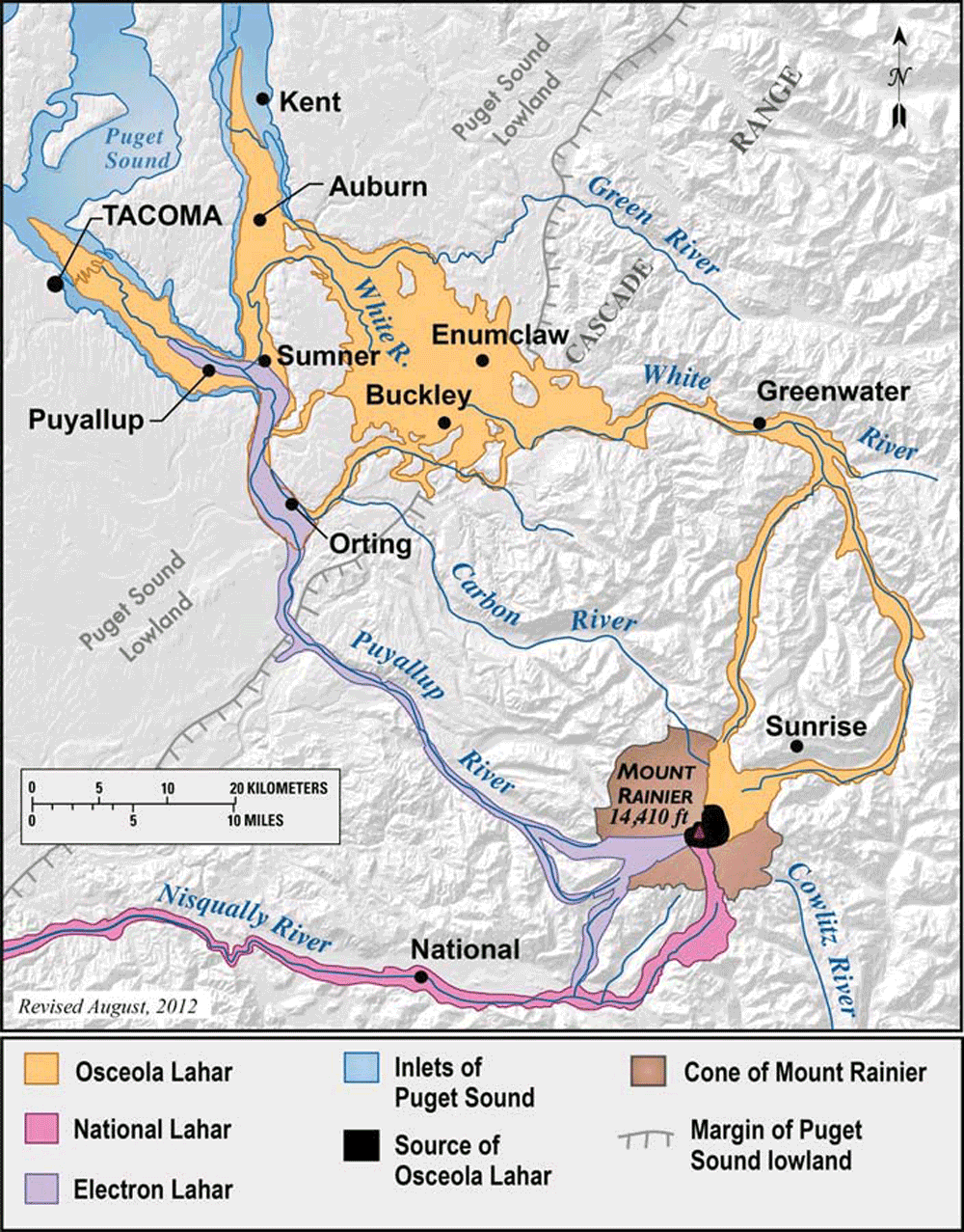
Lahar paths of Mt. Rainier. This map shows three major events that occurred in the last 10,000 years. Note how the lahars follow the river valleys. Map by the USGS (public domain).
Volcanoes
Located along the Pacific Ring of Fire, the Western U.S. contains many volcanoes. As can be seen in the table below, Alaska has the most volcanoes, most of which are found along the Aleutian Island Arc as a result of Pacific plate subduction.
| State | Number of volcanoes |
|---|---|
| Alaska | 97 |
| Oregon | 43 |
| California | 23 |
| Hawai‘i | 17 |
| Washington | 16 |
| Idaho | 10 |
| New Mexico | 10 |
| Arizona | 7 |
| Nevada | 5 |
| Utah | 5 |
| Colorado | 3 |
| New Hampshire | 2 |
| Virginia | 2 |
| Wyoming | 1 |
| Texas | 1 |
| South Dakota | 1 |
| Missouri | 1 |
| Mississippi | 1 |
The number of volcanoes in each U.S. state.
The USGS constantly monitors volcanoes in Alaska, California, Hawai‘i, Oregon, and Washington, as well as the Yellowstone area in Wyoming. Although the exact timing of a volcanic eruption is difficult to predict, there are many signs that a volcano is becoming active. Volcanologists on the watch for eruptions look for earthquake swarms, changes in the level of the land, changes in hydrothermal activity, and changes in the gases emitted by the suspect volcano. Because ash plumes can destroy jet engines in less than a minute, the USGS also issues warnings for aviation. Luckily, the most active volcanoes in the United States are either in Alaska, far from population centers, or in Hawai‘i, where shield volcanoes erupt without significant explosions or loss of life.
Cascade Range Volcanoes
California, Washington, and Oregon contain the Cascade Range’s volcanoes, which result from the subduction of the Juan de Fuca plate. All of the Cascade and Aleutian volcanoes are considered to be either active or dormant, which means they are capable of becoming active. Volcanic eruptions in the Cascades have been occurring for over 500,000 years, and have taken place at an average rate of two eruptions per century for the past 4000 years.
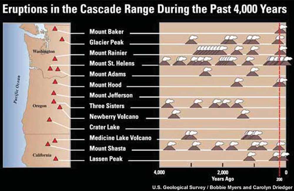
The eruptive history of the Cascade volcanoes over the past 4000 years. Image by the USGS (public domain).
Mt. Saint Helens, Washington
Mt. Saint Helens is the most active volcano in the Cascade Range. Its most spectacular eruption occurred on May 18, 1980, when an earthquake shook the side of the mountain, triggering the largest landslide ever recorded. An explosive blast issued from the side of the mountain, reaching speeds up to 480 kph (300 mph) as it flattened forests in its path. Avalanches of hot ash and pumice called pyroclastic flows sped quickly down the side of the volcano and spread for miles. The volcano’s rapidly melted glaciers created lahars that took out 27 bridges and 200 homes. Despite evacuations in the weeks leading up to the eruption, 57 people died during the explosion. It was the deadliest and most costly volcanic event in U.S. history. Mt. Saint Helens continues to be active, and it has built a lava dome inside its crater.
"Looking back at the Mount St. Helens eruption" by CBS Sunday Morning (YouTube).
Augustine Volcano, Alaska
Most volcanoes formed by subduction are stratovolcanoes, also known as composite volcanoes. Stratovolcanoes are built from the eruption of andesitic magma, which forms as the mantle above the subducting plate melts. This magma is viscous because of its high silica content, making it capable of trapping gasses and producing explosive eruptions. Stratovolcanoes eventually become layered with lava flows, pyroclastics, rock, and volcanic ash fragments ejected by an explosive eruption. They tend to be tall and cone-shaped, as can be seen in the picture of Augustine Volcano, located 300 kilometers (186 miles) southwest of Anchorage, Alaska.
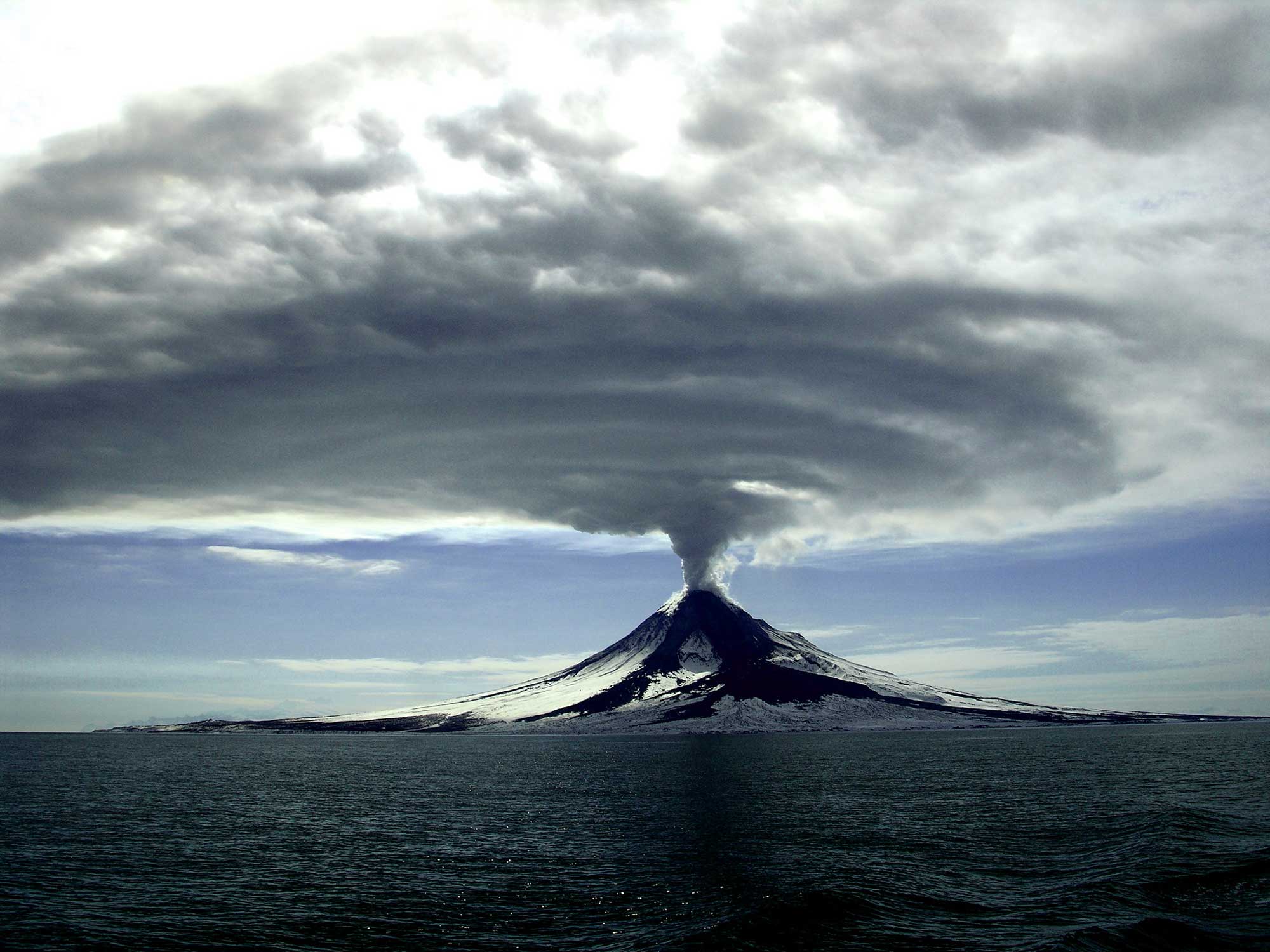
Eruption of Augustine Volcano in 2006. Photograph taken on March 27, 2006 by the USGS (Flickr; public domain).
When this volcano erupted in 1986, ash from an 11-kilometer (7-mile) high ash plume drifted over the Cook Inlet and grounded air traffic in Anchorage. Additional airline disruptions were caused by an eruption during 2006.
Katmai National Park, Alaska
Katmai National Park in Alaska is the site of the most powerful volcanic eruption in US history. In 1912, 13 cubic kilometers (3.1 cubic miles) of ash erupted from a vent on the side of Mt. Katmai. The ash completely filled a valley, which became known as the Valley of Ten Thousand Smokes for its many smoking fumaroles. The top of Mt. Katmai collapsed 1200 meters (3900 feet), creating an enormous caldera. After the explosive eruption, viscous rhyolitic lava pushed up from the vent, creating a volcanic dome, now known as Novarupta, which means “new volcano.”
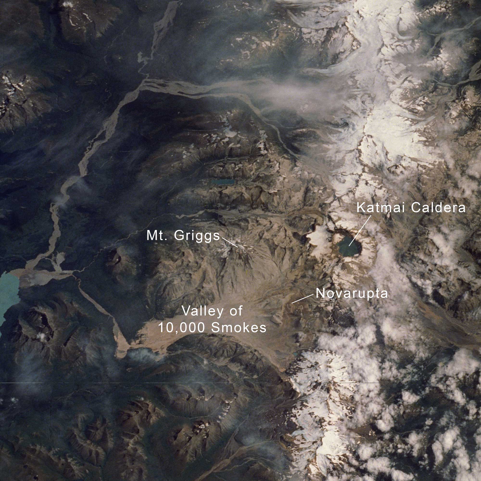
Katmai National Monument in Alaska. Photograph by NASA Johnson (Flickr; Creative Commons Attribution-NonCommercial 2.0 Generic license).
Long Valley Caldera, California
The Long Valley Caldera of California was the site of a colossal eruption 760,000 years ago.
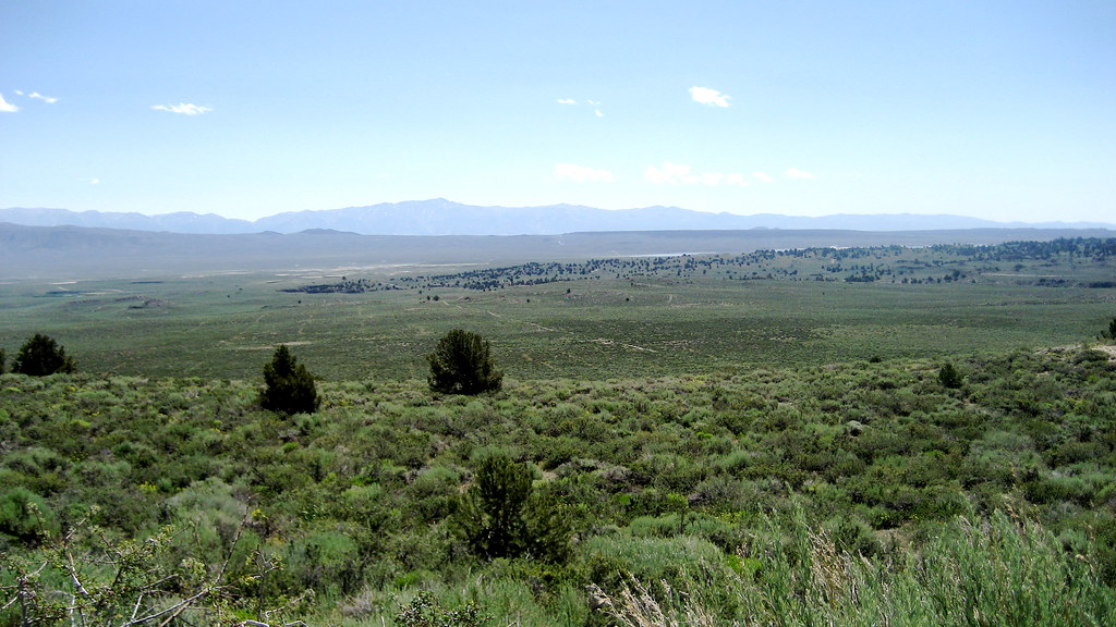
The Long Valley Caldera "as viewed from the edge of the resurgent dome" (original caption), California. Photograph by Jonathan Cook-Fisher (Flickr; Creative Commons Attribution-NonCommercial-NoDerivs 2.0 Generic license).
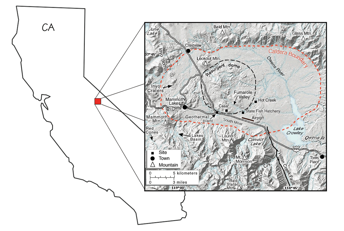
Extent and location of the Long Valley Caldera. Adapted from original image by the USGS (public domain).
The eruption created the Bishop Tuff ash layer (deposits of which cover an area nearly 2200 square kilometers [850 square miles] in size), and is estimated to have released 600 cubic kilometers (145 cubic miles) of ash, compared to the 1.2 cubic kilometers (0.3 cubic miles) of ash that was emitted by Mt. Saint Helens.
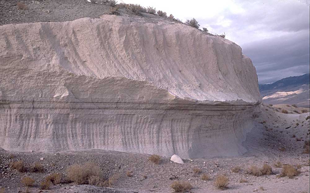
Exposure of the Bishop Tuff ash layer in eastern California. Original caption: "This outcrop is exposed in a rock quarry in Chalfant Valley about 25 km southwest of Long Valley Caldera. The two main units of the Bishop Tuff deposit are visible here: (1) the lower 5 m of the section consists of the pumice that fell to the ground (airfall pumice) downwind from the eruption; and (2) the upper 5-6 m of the section consists of the basal part of the pyroclastic flows that swept at hurricane speed away from the eruption. The thin dark "layers" just below the contact between the units are stains from an ancient groundwater table (manganese oxide stains)." Photograph by the USGS (Wikimedia Commons; public domain).
There is still no good explanation for the basaltic and rhyolitic magmas that underlie the area, since there is no associated hotspot or subducting plate. There are many related volcanic features in the area, including Mammoth Mountain (a ski resort that sits atop a lava dome complex), Panum Crater (a rhyolitic lava dome), and numerous hot springs such as Hot Creek, which is located on a resurgent dome in the center of the caldera.
Scoria Cone Landscapes: Mojave Desert and The Boring Lava Field
Scoria cones, also known as cinder cones, form as basaltic lava spews into the air and falls back onto the ejection site. The lava cools so quickly that volcanic gases become trapped in it as bubbles called vesicles. Scoria cones are small, steep, and short-lived. Scoria cone landscapes may appear ominous, but their effects are local, and they rarely cause a hazard to humans.
The Mojave Desert of southeastern California and southwestern Nevada is dotted with scoria cones and their associated basaltic lava flows. Amboy Crater and the Cima volcanic field of the Mojave National Preserve are excellent examples, among which the youngest scoria cone is only 10,000 years old.
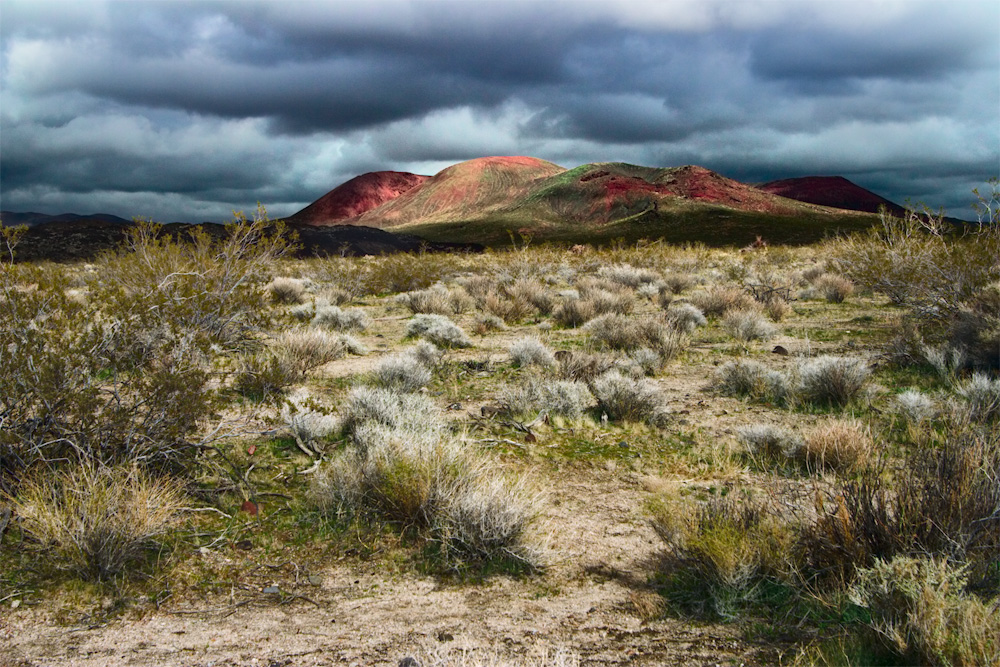
A cinder cone at Mojave National Preserve. Photograph by Rylee Isitt (Flickr; Creative Commons Attribution-ShareAlike 2.0 Generic license).
The Boring Lava Field, located near Portland, Oregon is an extinct lava field with 32 scoria cones.
Beacon Rock is part of the Boring Lava Field in Oregon. It is the central core of a cinder cone whose outer layers were stripped away 57,000 years ago by the Missoula Floods. Photograph by Eric Prado (Flickr; Creative Commons Attribution-NonCommercial 2.0 Generic license).
Climate change
The rapid release of carbon dioxide into the atmosphere from human activity is currently causing a global warming event. The seemingly slight increase in the average annual temperatures in the West has been accompanied by more frequent heat waves, shorter winters, and an increased likelihood of drought and wildfires. The contiguous Western states are currently experiencing severe drought throughout, with the worst effects occurring in California and parts of Nevada.
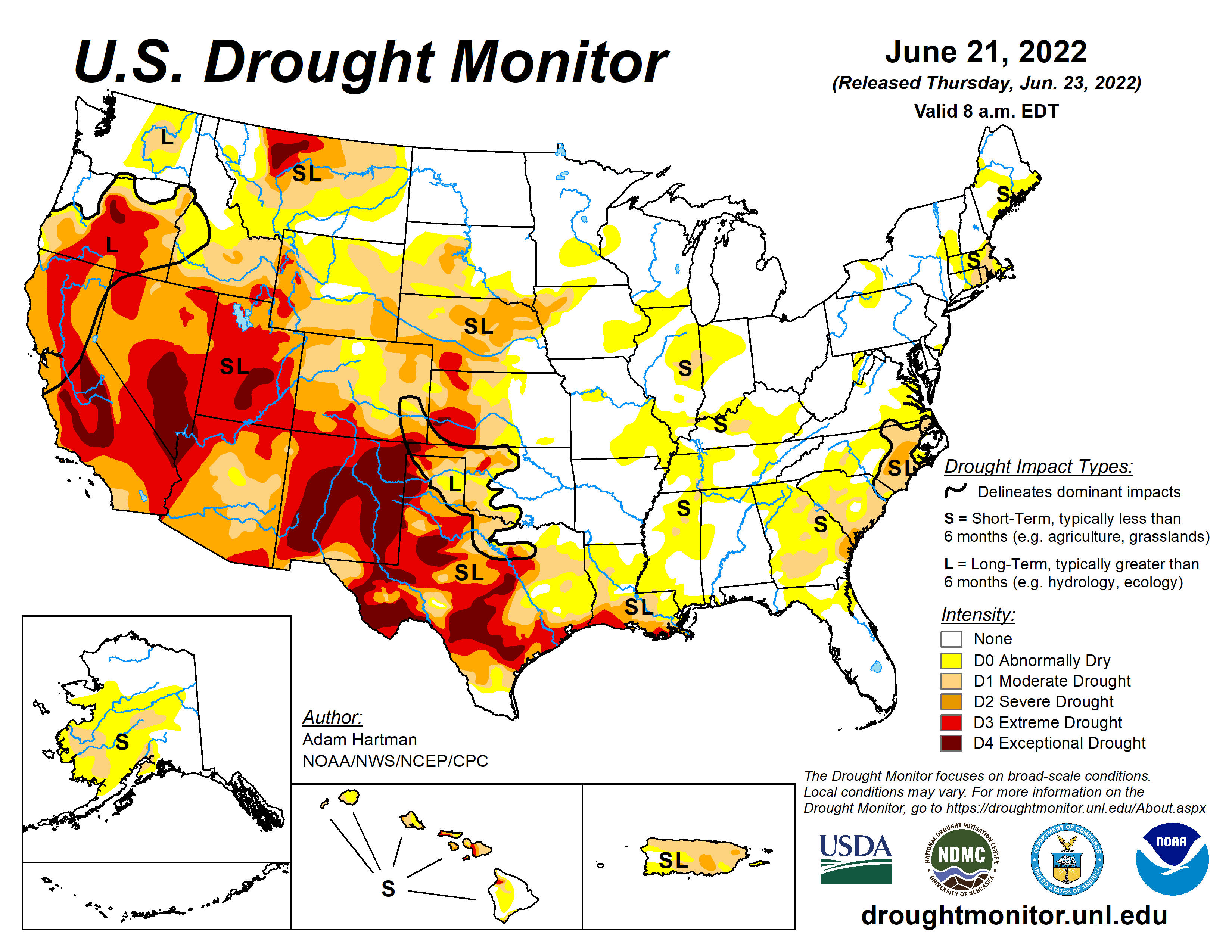
Drought conditions in the United States as of June 2022. Current drought conditions may be found here. The U.S. Drought Monitor is jointly produced by the National Drought Mitigation Center at the University of Nebraska-Lincoln, the United States Department of Agriculture, and the National Oceanic and Atmospheric Administration. Map courtesy of NDMC.
Wildfires
Increased dryness contributes to fire risk. In 2020, California experienced the most severe wildfire season in its history, with more than 4 billion acres burned. The fires caused more than $10 in property damage and resulted in severe air quality problems for millions of Californians.
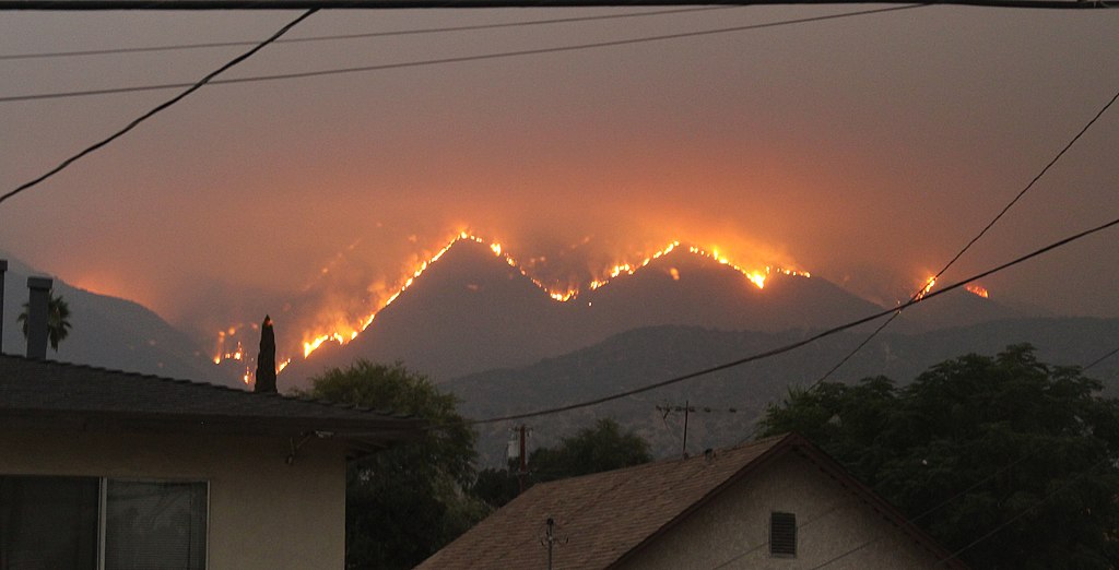
The Bobcat Fire near houses in Monrovia, California on September 10, 2020. Photograph by "Eddiem360" (Wikimedia Commons; Creative Commons Attribution-Share Alike 4.0 International license).
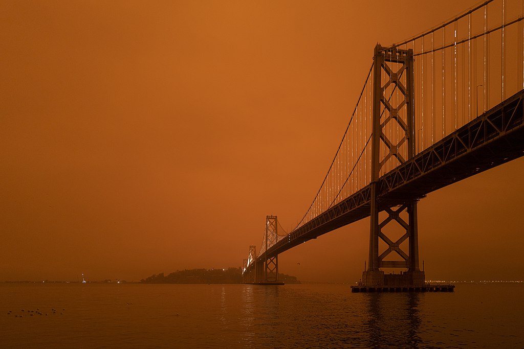
The Bay Bridge in San Francisco. The orange-colored sky is a result of smoke from nearby wildfires; photographed on September 9, 2020 at 9:55 AM. Photograph by Christopher Michael (Flickr; Creative Commons Attribution 2.0 Generic license).
Temperature
Besides wildfires, the warming climate is also resulting in the regular breaking of temperature records in the western United States. On July 9, 2021, the temperature at the Furnace Creek Visitor's Center in Death Valley, California reached 130°F (54.4°C), the highest temperature ever recorded on the surface of the Earth and 1/10 of a degree higher than the previous record set in August 2020 (learn more here). On April 8, 2022, Long Beach, California (near Los Angeles) reached a temperature of 101°F, 9 degrees higher than the previous record of 92°F set in 2014.
Increasing temperatures also allow for certain pests, such as ticks and mosquitoes, to live longer, thereby increasing the risk of contracting the diseases they carry. In addition, invasive insects that damage ecosystems, such as the spruce bark beetle in Alaska, will be better able to survive warmer winters, and will therefore increase and spread.
Water
Water supply is also a critical issue for the Western states. Much of the West obtains its water from precipitation, snowmelt, and runoff, which will dramatically decrease in quantity as temperature and aridity rise. The Arctic is warming nearly twice as fast as the rest of the planet—summer sea ice around Alaska has decreased by about 13% every decade since the 1970s. With melting ice comes an increase in sea level, and all of the Western states except Nevada have a considerable amount of oceanic coastline which will be affected by sea level rise.
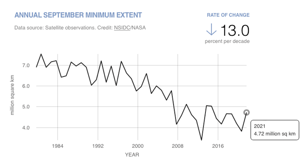
Extent of sea ice between 1979 and 2021. Image by NASA Scientific Visualization Studio (public domain).