


Page Snapshot: Introduction to glaciers of the western United States.
Contents
Topics covered on this page: Introduction; Brief history of glaciers in the west; Alpine glaciers in the western states; Glaciers and deserts; Continental glaciation in the western states; Glaciers and coastlines.
Credits: Most of the text of this page is derived from "Glaciers in the Western US" by Frank D. Granshaw, chapter 6 in The Teacher-Friendly Guide to the Earth Science of the Western US, edited by Mark D. Lucas, Robert M. Ross, and Andrielle N. Swaby (published in 2014 by the Paleontological Research Institution). This book were adapted for the web by Elizabeth J. Hermsen and Jonathan R. Hendricks in 2022. Changes include formatting and revisions to the text and images. Credits for individual images are given in figure captions.
Updates: Page last updated July 29, 2022.
Image above: Flowing glaciers converging in southeastern Alaska. Photograph by Jonathan R. Hendricks.
Introduction
The vast majority (nearly 97%) of the glaciers in the United States are found in the western states. Although the bulk of these are found in Alaska, small glaciers are found as far south as California and Nevada. These glaciers have a profound impact on the West’s scenery, geology, and water resources. Furthermore, ongoing research into how they have changed since the last major ice age is proving invaluable to our understanding of climate change.
Because of the large number of alpine glaciers in the western states, this area is one of the world’s “hotbeds” for glacier and climate research. Much of this work involves making regular inventories of existing glaciers and their characteristics to determine how they are impacted by global, regional, and local climate changes.
Equally important is determining the impact of the changing glaciers on seasonal streamflow. Glaciers act as water reservoirs where winter snowfall is released as meltwater during summer, when precipitation is low. This characteristic is particularly important to farms and fisheries in areas downslope from glaciated mountains like the Cascades or Sierra Nevada. In addition to investigating present-day glacier behavior, researchers use clues from the landscape to reconstruct ancient glaciers. This information, along with climate evidence from tree rings and lake sediments, provides a long view of climate change that has done much to improve our understanding of how climate systems work and what the future might have in store for us.
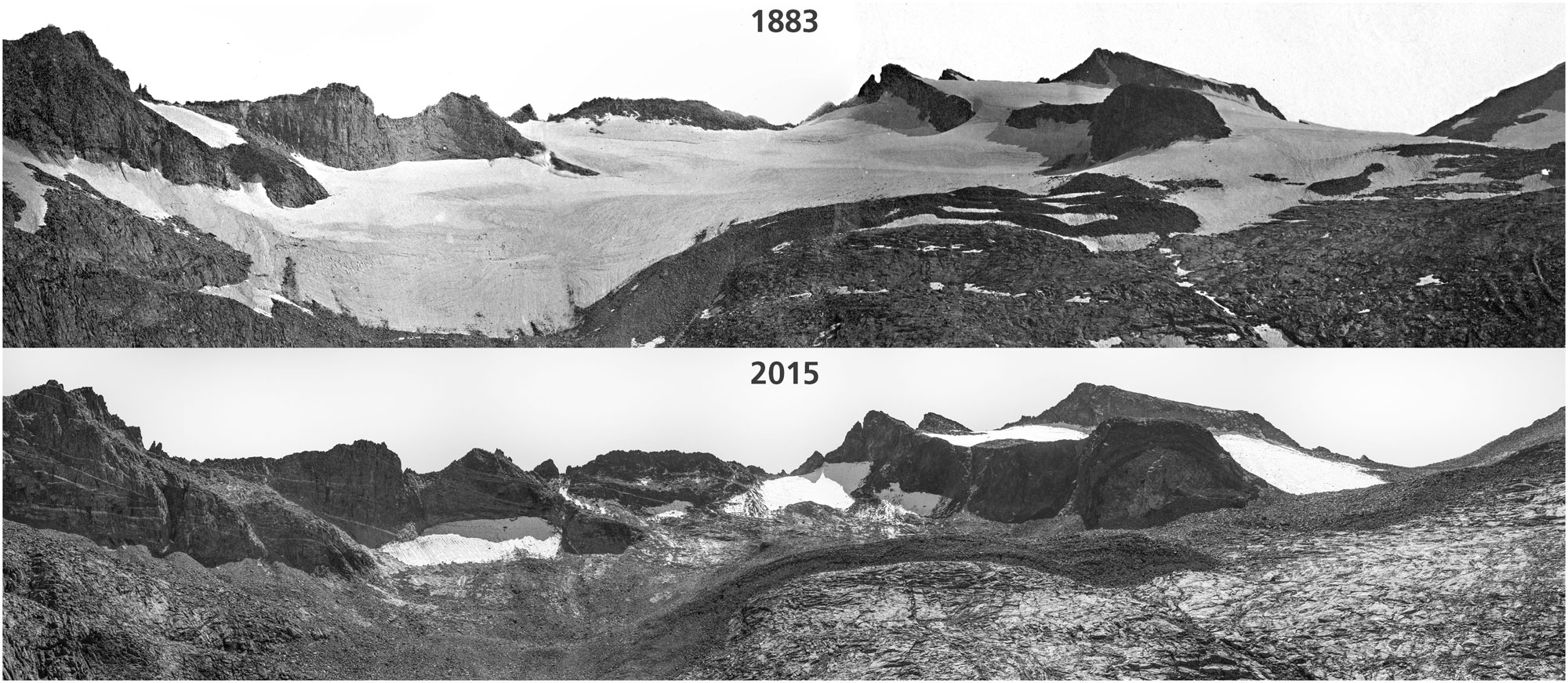
Lyell Glacier in 1883 compared to Lyell ice patch in 2015, Yosemite National Park, California. Photos by Israel Russell/USGS (1883) and Keenan Takahashi/NPS (2015). Source: NPS Climate Change Response on flickr (public domain).
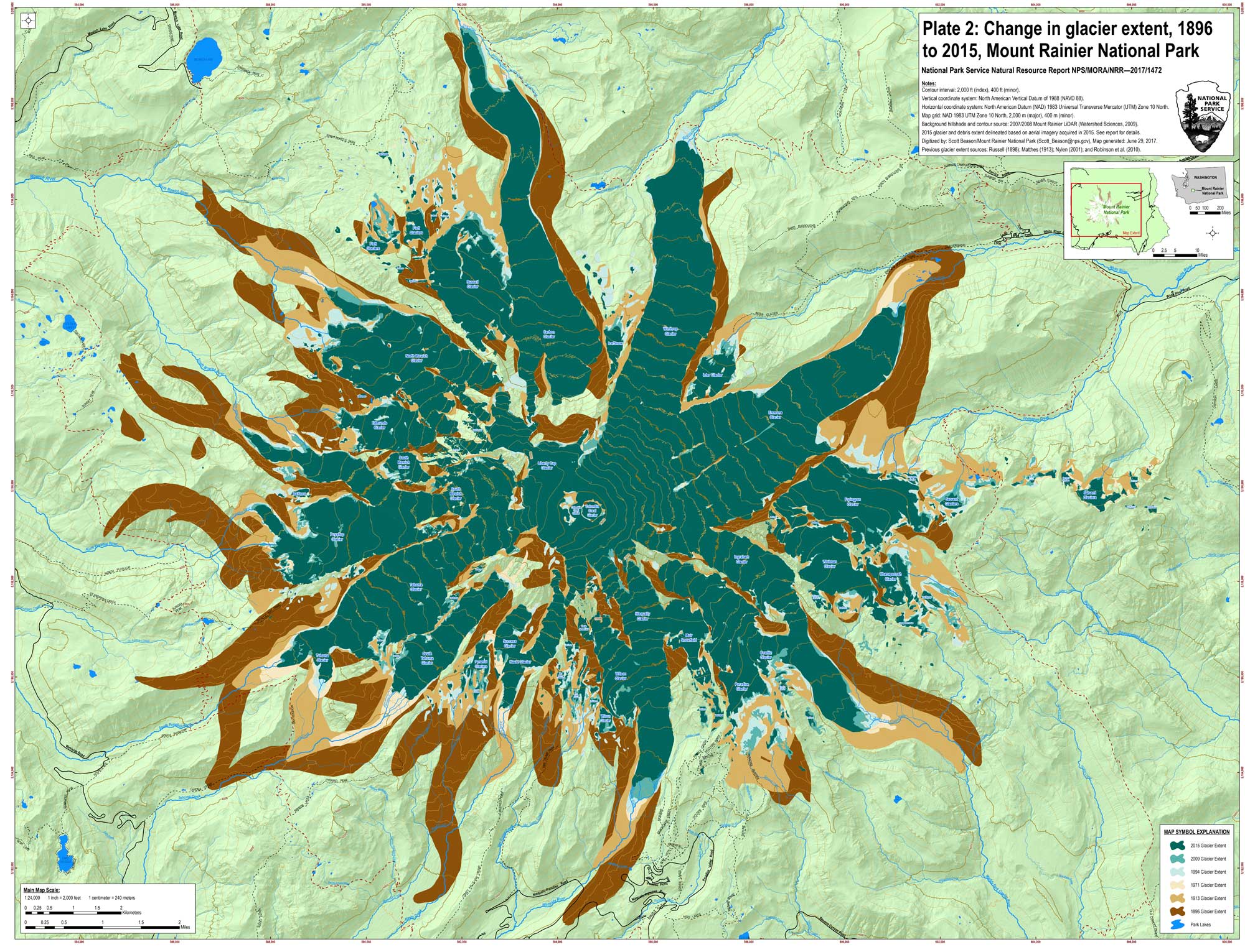
Extent of glaciers on the peak of Mount Rainier, Washington, at six points in time, from 1896 (dark brown) to 2015 (dark green). Map from Beason SR. 2017. Change in glacial extent at Mount Rainier National Park from 1896 to 2015. Natural Resource Report. NPS/MORA/NRR—2017/1472. National Park Service. Fort Collins, Colorado. (National Park Service Data Store).
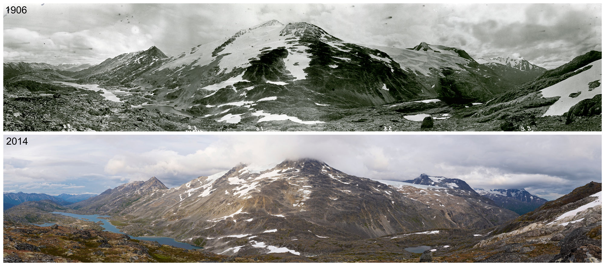
Chilkoot Pass on the Alaska-Canada border showing the retreat of glaciers. Top image is from 1906, bottom image is from 2014. Photos by George R. White-Fraser (International Boundary Commission, 1906) and Ronald D. Karpilo, Jr., and Sarah C. Venator (National Park Service, 2014). Source: NPS Climate Change Response on flickr (public domain).
Brief history of glaciers in the West
During the Pleistocene, continental glaciers covered much of Canada, Alaska, and the northern edge of the continental United States. Besides carving vast sections of the northern landscape and depositing huge quantities of sediment in low-lying areas, their impact was felt farther south as glacial outburst floods and winds laden with glacial loess reached deep into Washington and Oregon. Furthermore, in the colder climate of the Pleistocene, large ice caps mantled mountain ranges as far south as Central California, while large freshwater lakes flooded a number of present-day desert valleys in Nevada, California, and Oregon.
As the last Pleistocene ice age came to a close, both the Cordilleran Ice Sheet and the alpine ice caps to the south retreated, leaving behind rugged mountain ranges, deep glacial valleys and bays, and plains covered with thick deposits of glacial sediment. Equally important was the impact of glacial retreat on coastlines. As global ice diminished, sea level rose, radically altering the location and character of the Western coasts.
The time from the end of the Pleistocene to now is regarded as an interglacial period (a warm spell with diminished glaciers), but it has not been without its minor ice ages. The most recent of these, the Little Ice Age, began somewhere between 1300 and 1500 CE and ended by the late 19th century. Presently, the continental ice sheets and ice caps of the Pleistocene are gone, but some 150,000 alpine glaciers remain worldwide, and the impact of the ancient ice sheets and caps can be seen in nearly every region of the Western States.
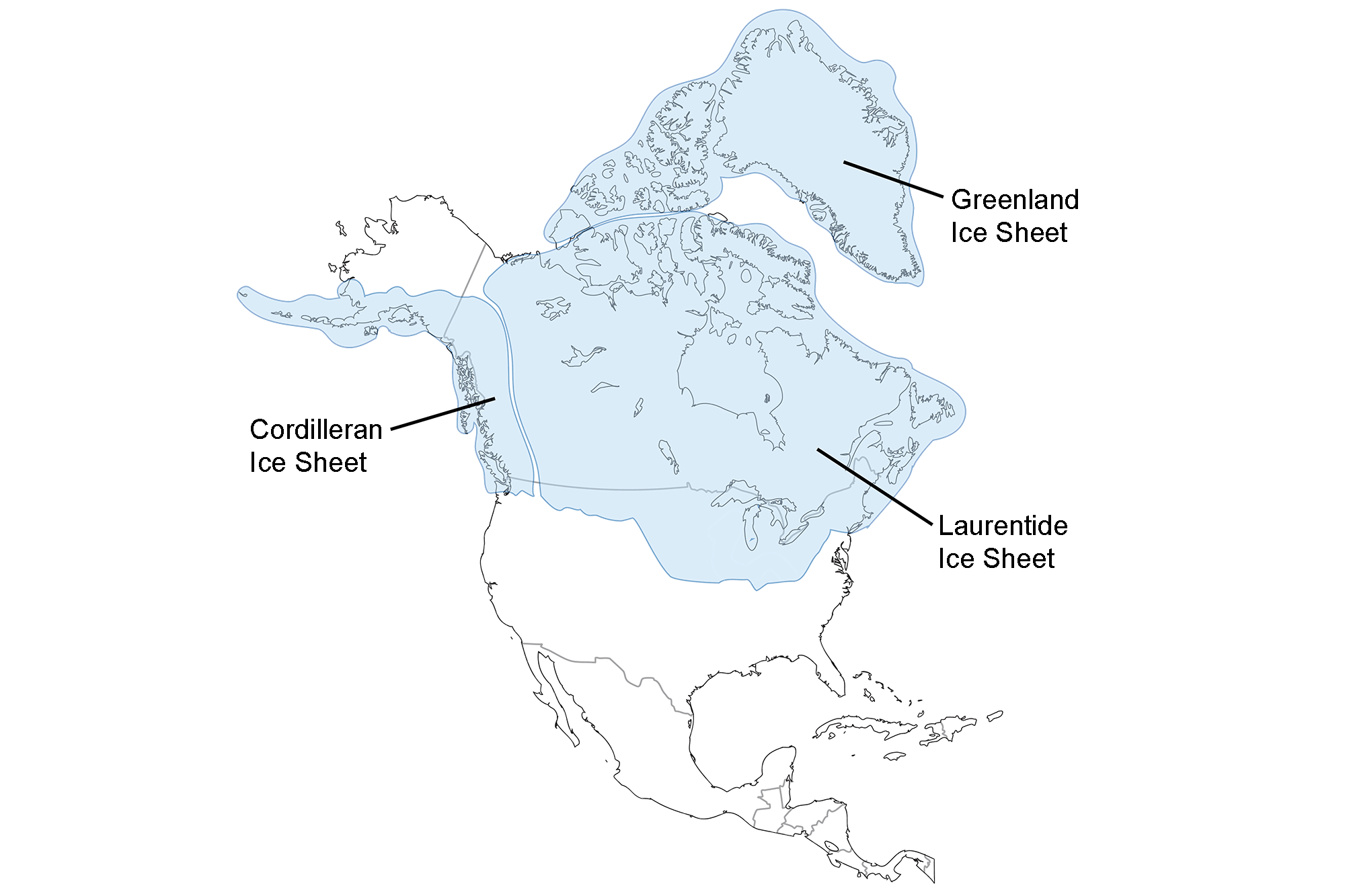
Extent of glaciation over North America at the Last Glacial Maximum. Image adapted from map by the USGS (public domain).
Alpine glaciers in the western states
During the late Pleistocene, alpine glaciers could be found in all regions of the Western States. In several cases, these glaciers coalesced into ice caps covering entire mountain ranges. In other instances, they merged with advancing continental ice sheets, eventually becoming indistinguishable as separate glaciers. These glaciers only to regained their distinctiveness as the ice sheets retreated.
Today, alpine glaciers are found largely in the mountains of Alaska and some of the higher ranges in Oregon, Washington, and California. Although the majority of the remaining glaciers tend to be small cirque glaciers or larger valley glaciers, a few large ice caps remain in southeastern Alaska. Modern glacier settings range from non-volcanic mountains like the Olympics and Sierra Nevada to active volcanic peaks found in the Cascade Range and the Aleutian Islands. As one moves farther south in the Western States, the glaciers tend to get smaller and higher. For instance, in southeastern Alaska, large outlet glaciers flow out of the massive Juneau Ice Field into the Pacific Ocean through a network of majestic fjords. In contrast, in the Sierra Nevada, a collection of small cirque glaciers perch precariously in mountains at well over 2700 meters (9000 feet) above sea level.
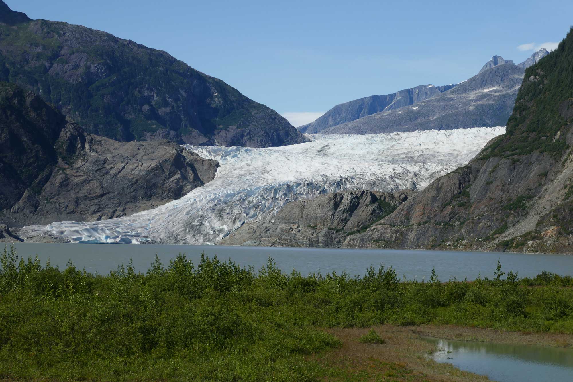
Mendenhall Glacier, flowing from the Juneau Ice Field. Photograph by Jonathan R. Hendricks.
One of the hallmarks of the alpine glaciers of the contiguous western States is the rugged mountain terrain they carve. As these glaciers retreat, they expose characteristic U-shaped valleys and reveal a diverse collection of peaks, bowls, and ridges scraped into bedrock. For instance, in the North Cascades of Washington and in the Wallowa Mountains of Oregon, glaciers have carved a series of horns, arêtes, and cirques.
Glaciers also impact landscapes as they melt and deposit sediment. Chains of lakes form as meltwater ponds behind lateral and terminal moraines. For example, Lake Wallowa in the Blue Mountains of northeastern Oregon formed when a large glacier emptied into a broad basin and produced a high moraine that surrounded the lower part of the glacier. As the glacier retreated, the depression behind the moraine filled with meltwater, forming the present-day lake.
In the Yosemite Valley of the Sierra Nevada, a network of small Pleistocene glaciers merged like streams flowing into a large river. As the glaciers retreated, they left behind a collection of smaller U-shaped valleys (known as hanging valleys) that drop abruptly into a much larger valley. This is the principal reason that such spectacular waterfalls are found in the Yosemite Valley.
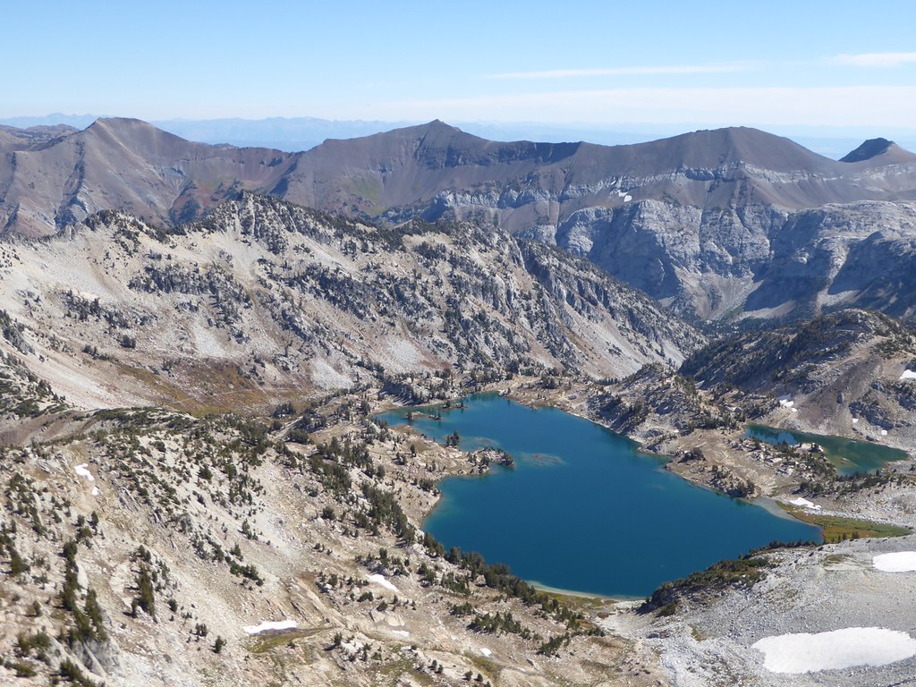
The glacially sculpted features of the Wallowa Mountains in Oregon. Image by George Kraus (Flickr; Creative Commons Attribution-NonCommercial-NoDerivs 2.0 Generic license).
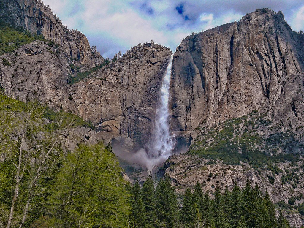
Upper Yosemite Falls in California plunges 440 meters (1420 feet) from a hanging valley into the Yosemite chasm. Photograph by Jim & Robin (Flickr; Creative Commons Attribution 2.0 Generic license).
Among the most dramatic glacial deposits found in the Western States are those produced by glacial outburst floods. These floods occur when a pocket of meltwater that has developed underneath a glacier suddenly breaks through the restraining ice. As the torrent rushes downhill, it picks up rock, sediment, vegetation, and any other debris it can carry, forming a fast-moving slurry that is a significant hazard for many mountain communities. With a number of glaciers in the Cascades and Alaska situated on steep, debris-covered volcanoes, glacial outburst floods are all too common.
Original caption: "Water burst from the terminus of a glacier on Mount Rainier August 8, 2019, creating new waterfalls and tumbling boulders downstream. The resulting damage closed a road and trail in the national park." Video by The News Tribute (via YouTube).
Glaciers and deserts
The arid climate of the Basin and Range and Columbia Plateau may seem like an unlikely place to study glaciers, but even these regions did not escape the influence of the last ice age. The cooler climate of the late Pleistocene glaciation allowed ice caps to mantle entire mountain ranges, while meltwater ponded in basins between these ranges to form numerous, large, shallow, pluvial lakes (inland lakes that do not drain to another body of water). The most famous of these is probably Bonneville, which covered much of Utah. However, pluvial lakes also covered large parts of Nevada and southern Oregon. One of the largest was Lake Lahontan in Nevada; the modern-day Pyramid Lake is one of the remnants of this Pleistocene lake.
As the climate warmed, the ice caps disappeared, leaving in their wake a multitude of cirques and U-shaped valleys. At the base of the mountains, moraines and deposits of till testify to the lower extent of the glaciers, while glacial drift deposits and dry waterfalls reflect the power of the meltwater streams issuing from them. The pluvial lakes are now gone, leaving behind salt flats and pockets of fine-grained lake sediment buried under the coarser desert sediment. In many of the West’s deserts, wave-cut benches that resemble bathtub rings are visible around the upper perimeter of the basins.
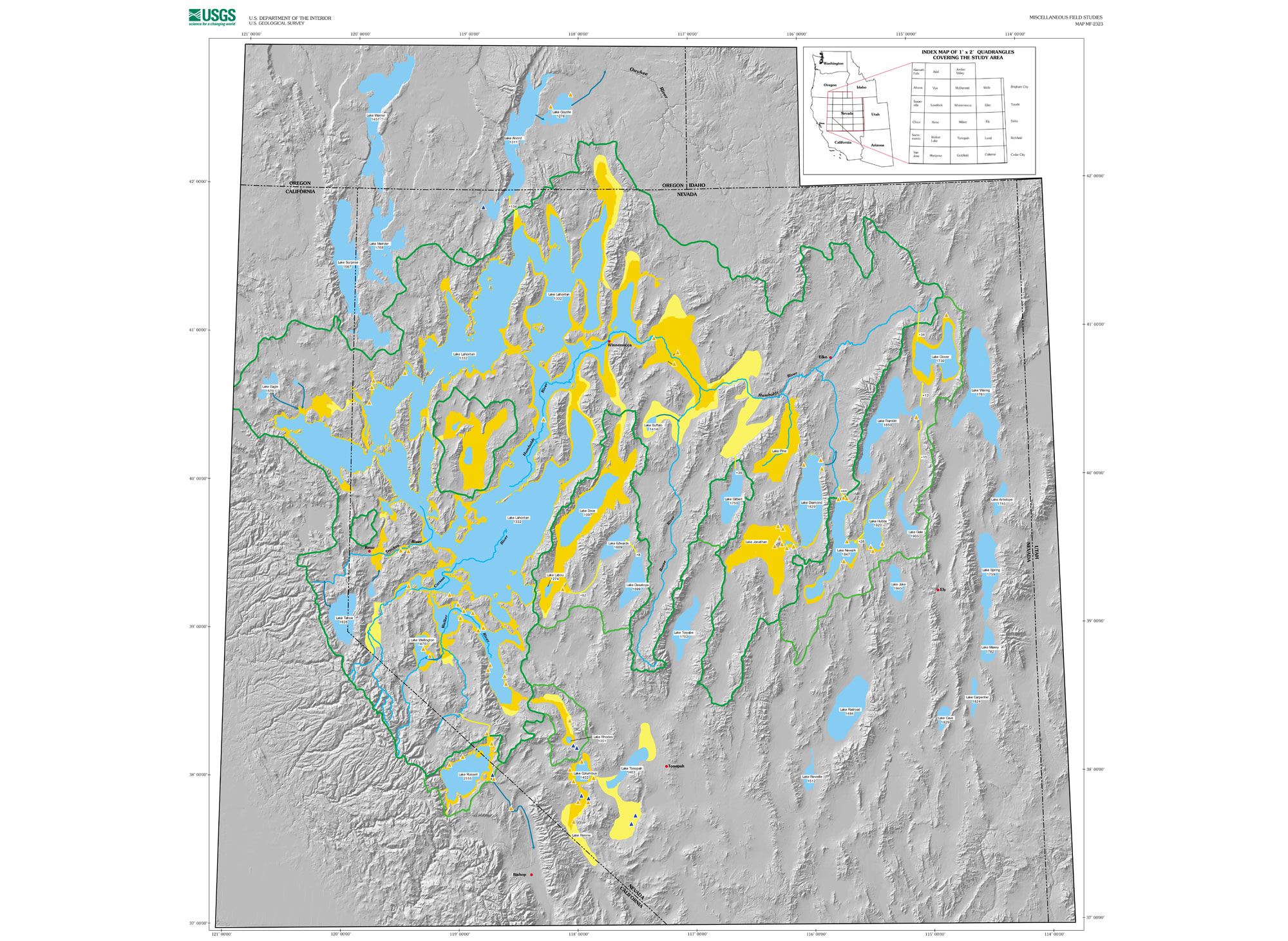
Map of Pleistocene lakes in Nevada, southern Oregon, and eastern California. Blue = late Pleistocene lakes; orange = maximum extent of lakes earlier in the Pleistocene; yellow = possible additional lake extent earlier in the Pleistocene. Map by Marith Reheis, 1999 (USGS).
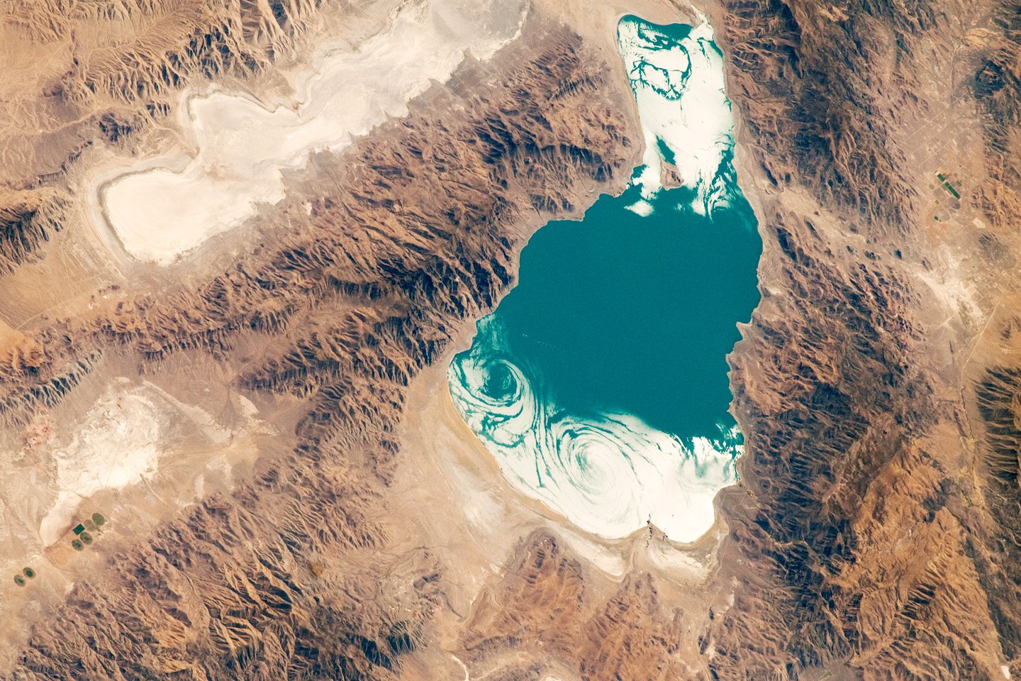
Pyramid Lake, Nevada, 2010. This lake was once part of the larger Pleistocene Lake Lahontan. Source: Astronaut photograph ISS025-E-5259, Expedition 25 Crew, NASA Earth Observatory (used in accordance with NASA's image use policy).
Continental glaciation in the western states
Continental glaciers are now only a geologic memory in the western states, yet the picture was much different during the Pleistocene. Nearly 20,000 years ago, the Cordilleran Ice Sheet covered nearly all of western Canada and parts of the United States. In Alaska, it covered only the southern half of the state, a result of weather patterns that drove snow-laden storms away from the state’s northern section. In northern Washington, outlet glaciers and ice lobes reached down through the Okanogan Highlands and Puget Sound before spilling out onto the lowlands of the Columbia Plateau and southern portions of the Sound. In the vicinity of the North Cascade and Olympic ranges, the outlet glaciers merged with the ice caps that had formed over the range.
One result of the Pleistocene glaciations were huge, U-shaped valleys in the Okanogan Highlands, North Cascades, and Olympics that were carved by outlet glaciers of the Cordilleran Ice Sheet. In Puget Sound, a large lobe, along with the meltwater draining it, sculpted a complex system of fjords while dumping masses of drift nearly 300 meters (1000 feet) thick. This flowing ice and water also sculpted hundreds of drumlins and bedrock hills into linear shapes that marked the flow direction of the ice.
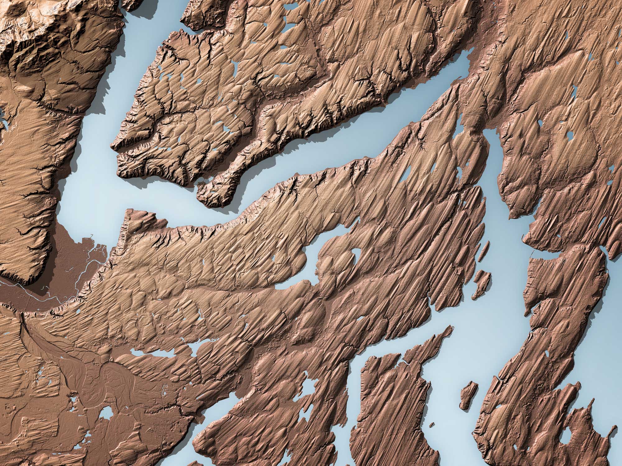
Reconstruction of the relief in a drumlin field, Hood Canal, Puget Lowland, Washington. Image by Daniel E. Coe, Washington Geological Survey (Washington DNR on flickr, Creative Commons Attribution-ShareAlike 2.0 Generic license, image resized).
Columbia Plateau
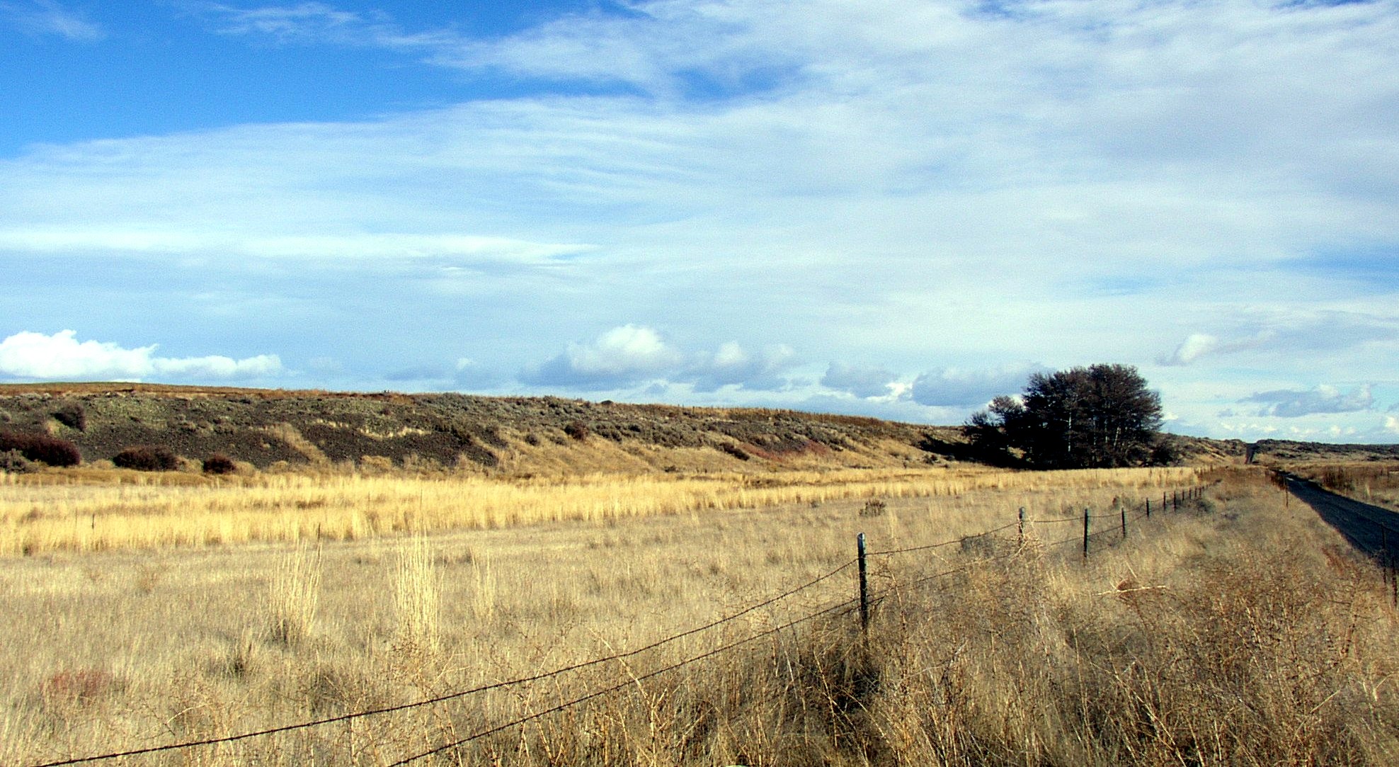
Farther to the east, in the Columbia Plateau, the deposits were sculpted into snake-like ridges called eskers. These are believed to be the result of streams flowing through tunnels at the bottom of the glacier that filled up with sediment. In the northern section of the plateau, house-sized boulders (erratics) left behind by the receding ice force farmers to creatively plow their fields. In other parts of the plateau, silt blown from the outwash plains (loess) was deposited well over a hundred miles south of the ice sheet terminus.
Another way the Cordilleran Ice Sheet shaped the Columbia Plateau was by numerous catastrophic floods emanating from the Pleistocene-age glacial Lake Missoula. These flows, sometimes called the Bretz Floods after the geologist who discovered them, would periodically race across the plateau, scouring bedrock and transporting massive amounts of sediment and rock to the Willamette Valley and beyond. The cause of the floods is commonly attributed to meltwater from ancient Lake Missoula, which was repeatedly dammed by glacial ice and then drained when the ice dam abruptly failed. These floods scoured the region known as the Channeled Scablands and cut through thick layers of loess that have previously been deposited in Idaho, Oregon, and Washington (a portion of these channeled loess deposits is known as the Palouse). During the Pleistocene, similar floods occurred in east and south-central Alaska and in the Sierra Nevada.
An esker (the long, low hill in the background of the image), Sims Corner Eskers and Kames National Natural Landmark, Washington. Photo by Williamborg (Wikimedia Commons, public domain).
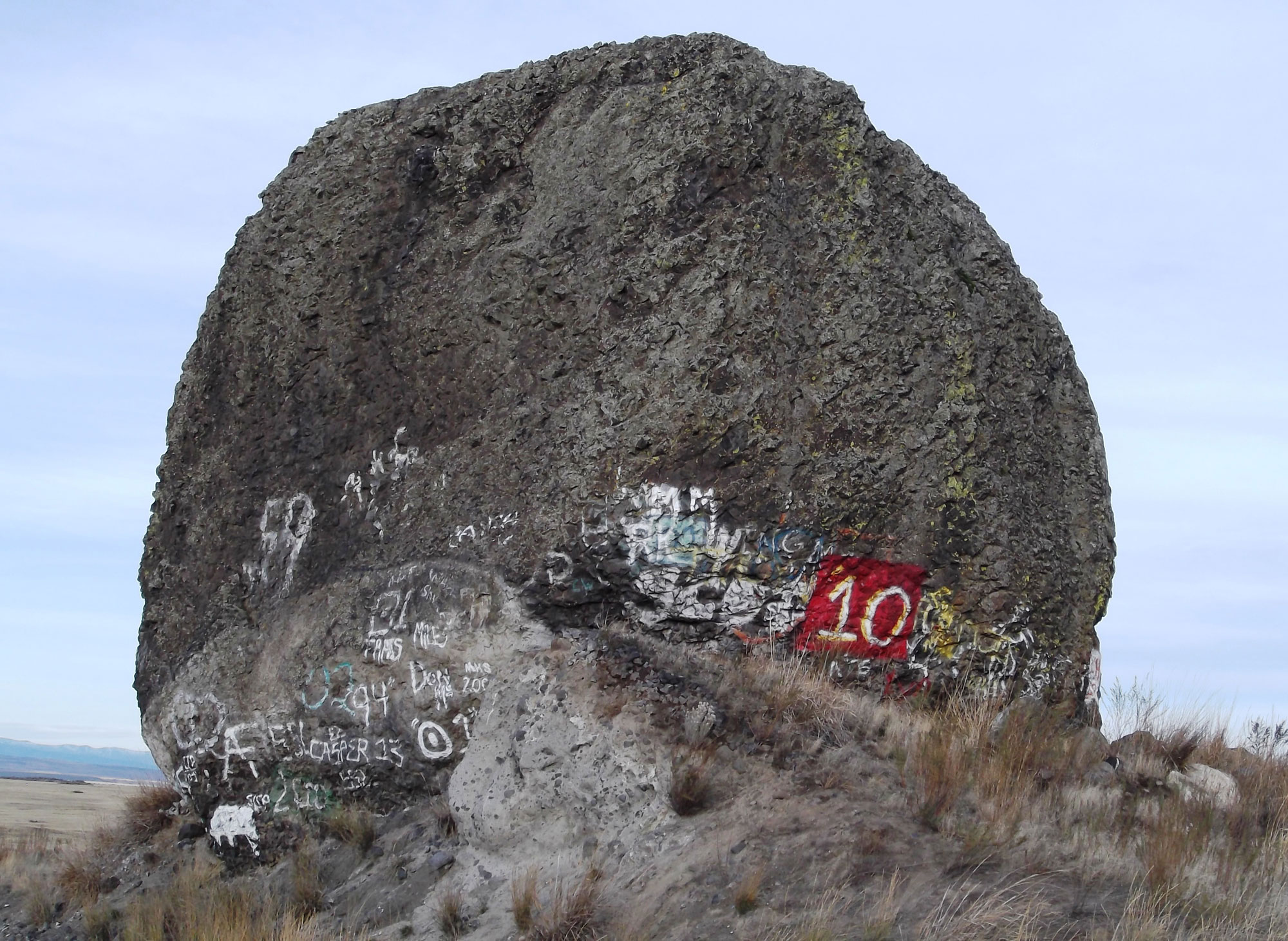
Yeager Rock, a large glacial erratic in central Washington. Photo by brewbooks (flickr, Creative Commons Attribution-ShareAlike2.0 Generic license, image cropped and resized).
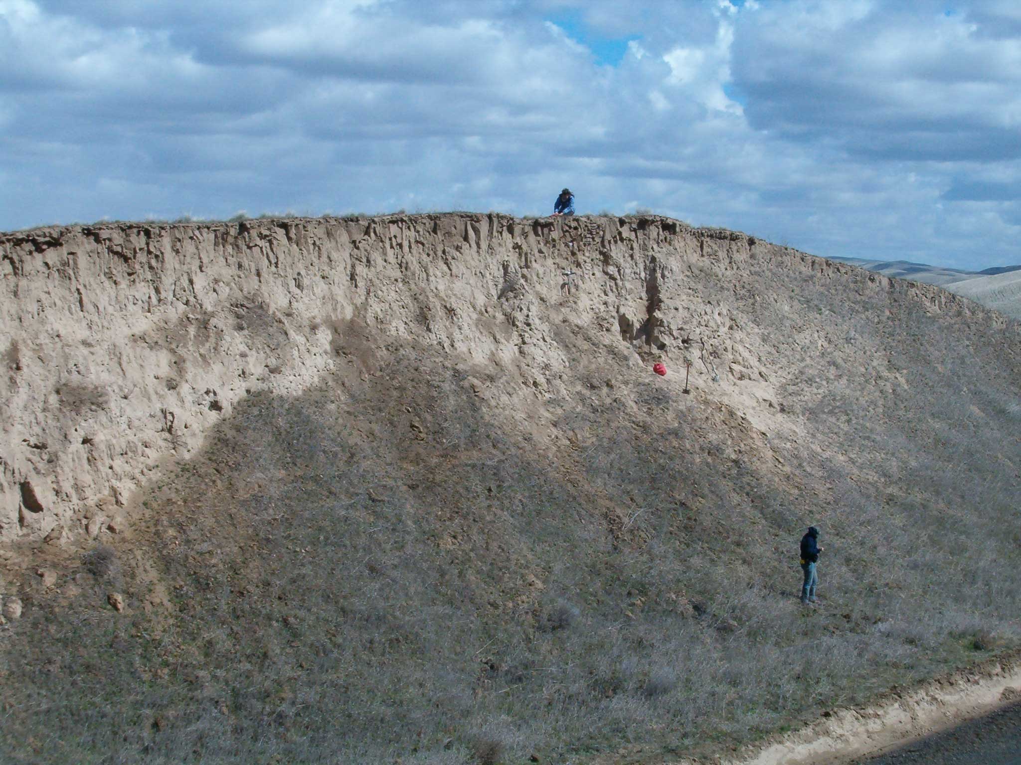
A 10-meter-thick Pleistocene (ca. 75,000 years old) loess deposit near Eureka Flat, southeastern Washington. Photo by Mark Sweeney, University of South Dakota (SERC, Creative Commons Attribution-NonCommercial-ShareAlike 3.0 Unported license).
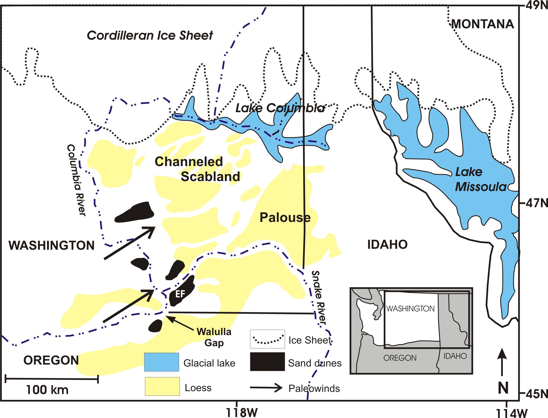
Original caption: "Depiction of the Channeled Scabland and Palouse region during the last glacial maximum. Old loess was scoured by floods to leave a braided network of loess islands. Floods sediments deposited in basins were reworked by the wind to form sand dunes (black) and loess (yellow). EF is the location of Eureka Flat." Map by Mark Sweeney, University of South Dakota (SERC, Creative Commons Attribution-NonCommercial-ShareAlike 3.0 Unported license).
Glaciers and coastlines
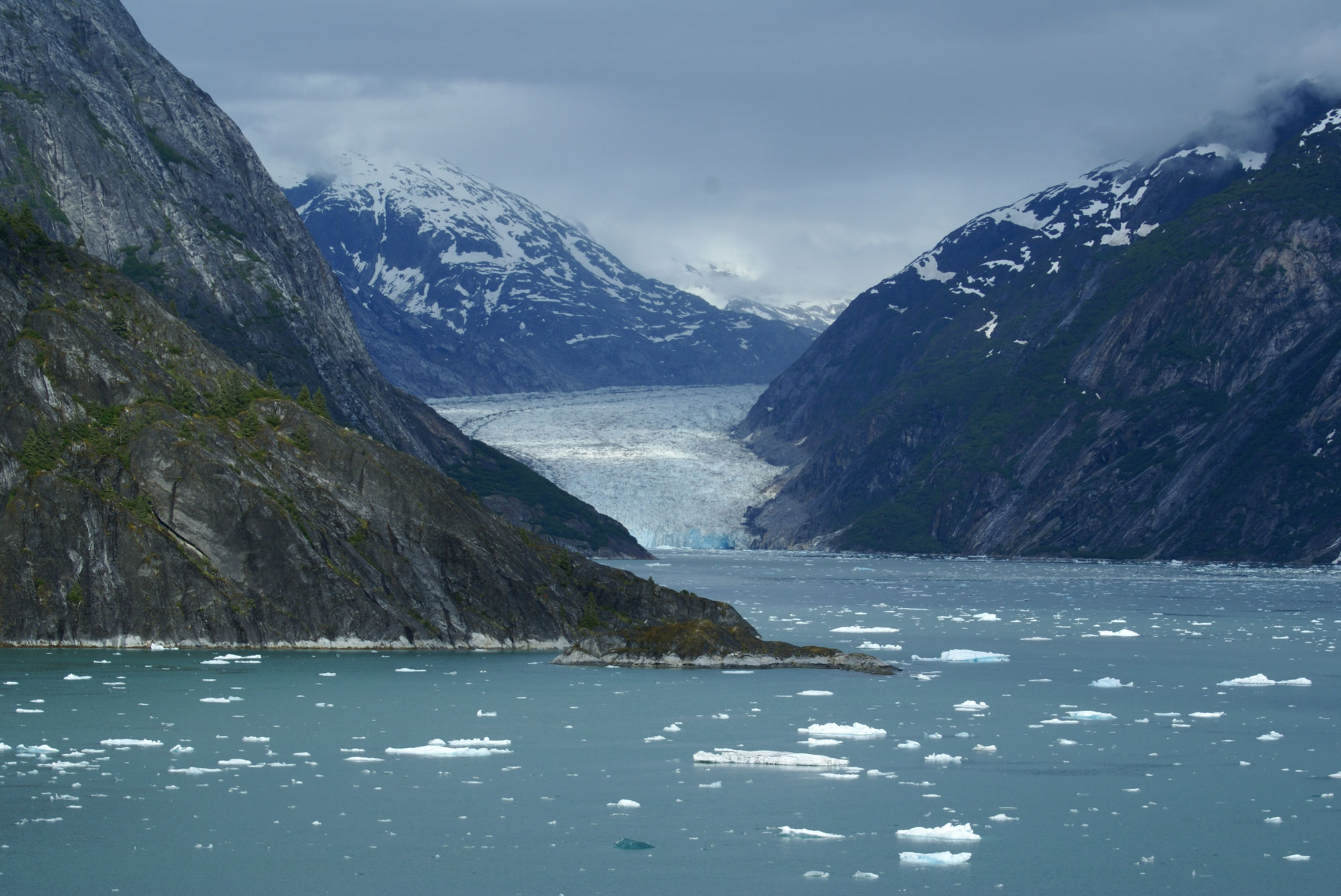
Glaciers have shaped the coastlines of the western states in three ways. In Alaska, where they reach to the sea, outlet glaciers carve intricate systems of fjords, creating exceedingly rugged coastlines. Since many of these glaciers flow into the ocean, they lose mass by calving. In this way, they create countless icebergs that deposit a chaotic mix of rock and sediment on the seafloor as they melt. Though these sediments are not readily visible in Alaska, they are common along the coast of Washington.
Dawes Glacier, Endicott Arm Fjord, Alaska, 2008. Photo by Richard Martin (flickr, Creative Commons Attribution 2.0 Generic license, image resized).
Hubbard Glacier, Alaska. Ice calves from the glacier into Disenchantment Bay. Photograph by Jonathan R. Hendricks.
Another way that glaciers have shaped the west coast is through the rise and fall of sea level. Approximately 20,000 years ago, the coast of Oregon, Washington, and California was 65 to 130 kilometers (40 to 80 miles) farther west than it is now, since sea level was nearly 90 meters (300 feet) lower. At that time, the coast was most likely a broad plain that gradually rose to the base of the present-day coastal mountain ranges. As the ice sheet retreated, increased meltwater flowed back into the sea. As the sea rose, the shoreline advanced eastward towards the mountain ranges, eventually resulting in a shoreline characterized by rocky headlands, small beaches, and large estuaries.
As present-day glaciers diminish in size and sea level continues to rise due to changes in global climate, several factors complicate our predictions of how the coastlines of the western states will change. Chief among these is the slow rise of the crust at the western edge of North America due to plate tectonics and subduction. Another significant influence is the continuing slow rebound of the northern half of North America, brought about by the disappearance of the great Pleistocene ice sheets. The degree to which these factors will offset rising sea levels is both a practical and theoretical concern, given the vast number of people living on or near the coastline of the western states.
Resources
Resources from the Paleontological Research Institution
Earth@Home: Here on Earth: Introduction to Glaciers: https://earthathome.org/hoe/glaciers/