

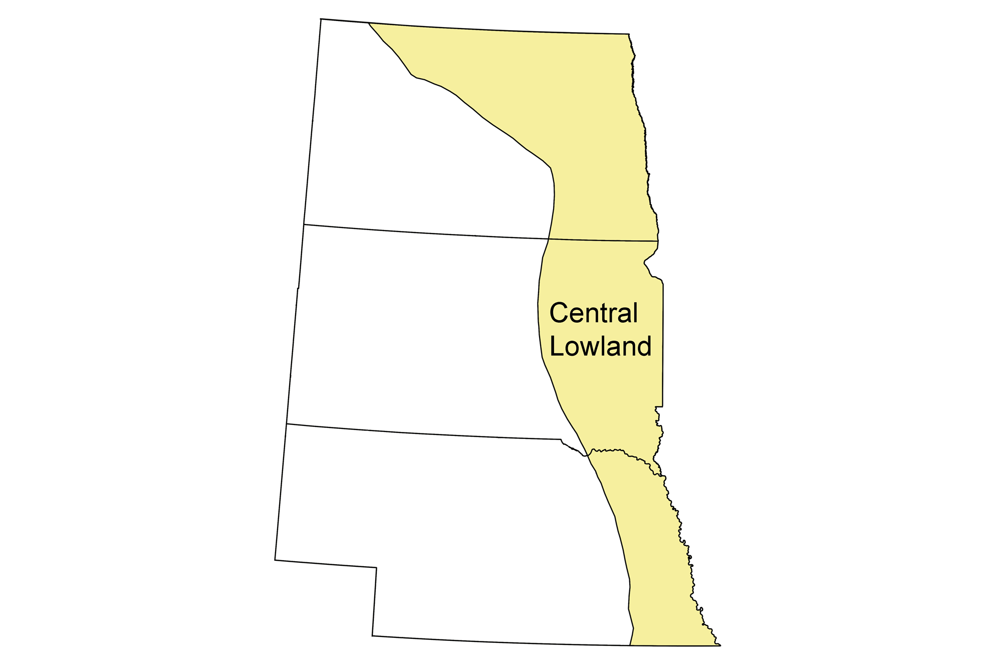
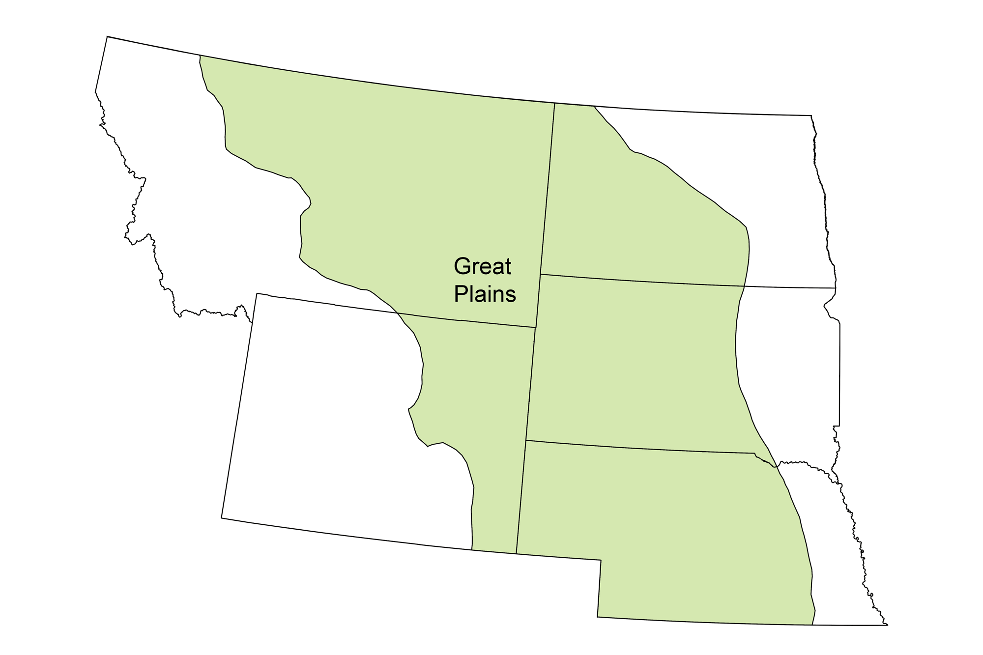
Snapshot: Overview of the mineral resources of the Central Lowland and Great Plains regions of the northwest central United States, including North Dakota, South Dakota, Nebraska, Montana, and Wyoming.
Topics covered on this page: Overview; Salts; Industrial Minerals; Metals; Black Hills; Resources.
Credits: Most of the text of this page is derived from "Mineral resources of the Northwest Central US" by Thom R. Fisher and Robert M. Ross, chapter 5 in The Teacher-Friendly Guide to the Earth Science of the Northwest Central US, edited by Mark D. Lucas, Robert M. Ross, and Andrielle N. Swaby (published in 2015 by the Paleontological Research Institution). The book was adapted for the web by Elizabeth J. Hermsen and Jonathan R. Hendricks in 2021–2022. Changes include formatting and revisions to the text and images. Credits for individual images are given in figure captions.
Updates: Page last updated October 19, 2022.
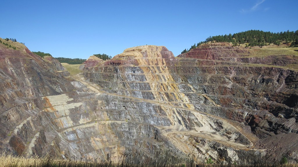
Image above: Modern appearance of the Homestake Mine Pit in Lead, South Dakota. Image by Larry Myhre (Flickr; Creative Commons Attribution-NonCommercial-ShareAlike 2.0 Generic license). Compare with historical image below.
Overview
The Great Plains and Central Lowland compose a topographically flat expanse that slopes gently eastward toward the mid-continent. Once partly glaciated, these regions are now characterized by rolling, grassy plains and farmland. The land is interrupted only by river and stream valleys and other erosional features formed during the Holocene, except for the Black Hills of Wyoming and South Dakota, and a few outlying Precambrian rocks that protrude through the Quaternary sedimentary cover. Geologically, the Black Hills are the easternmost outpost of the Rocky Mountains and account for considerable mineral wealth in the Great Plains region.
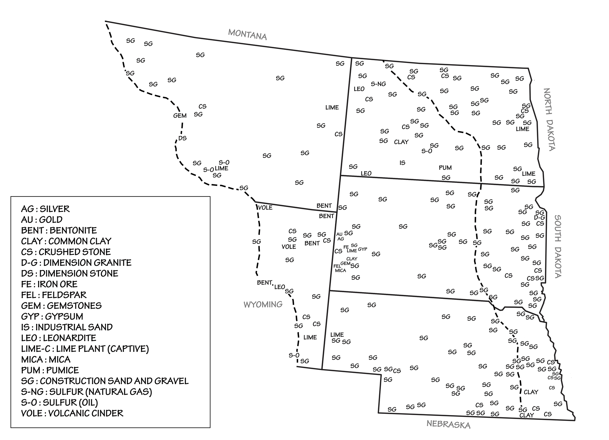
Principal mineral resources of the Great Plains and Central Lowland. Image by Wade Greenberg-Brand, adapted from USGS 2009 State Minerals Yearbook.
Salts
Beneath the surface cover of Neogene- and late Quaternary-aged sediments lies a series of sedimentary and structural basins formed during the Laramide Orogeny (about 70 to 40 million years ago) and earlier tectonic events preceding the Laramide.
Large halite deposits that formed nearly 400 million years ago in the warm, evaporating seas of the Devonian are found deep beneath the Williston Basin of North Dakota and Montana. These salt beds represent a massive resource of potash, a name used for a variety of salts containing potassium, with mined potash being primarily potassium chloride. The majority of potash is used as fertilizer, but an increasing amount is being used in a variety of other ways: for water softening, for snow melting, in a variety of industrial processes, as a medicine, and to produce potassium carbonate.
Several saline lakes on the northern and northwestern plains of North Dakota are “mined” for salts such as sodium sulfate (NaSO₄), often in the form of mirabilite (also known as “Glauber salts” in its processed form).
Sample of mirabilite from the Great Salt Lake, Utah. Photograph by Bryant Olsen (Flickr; Creative Commons Attribution-NonCommercial 2.0 Generic license).
This mineral is used in the manufacture of detergents, paper, and chemical processing, especially in the production of hydrochloric and sulfuric acids. The playa lakes that produce these salts were originally potholes created during the last glaciation of North Dakota.
Halite is mined in two ways. When deposited in thick beds, this salt can be excavated by mechanically carving and blasting it out. This method, called “room and pillar” mining, usually requires that pillars of salt be left at regular intervals to prevent the mine from collapsing.

n pillar and room mining, the mine is divided up into smaller areas called "panels." Groups of panels are separated from one another by extra-large (barrier) pillars that are designed to prevent total mine collapse in the event of the failure of one or more regular-sized (panel) pillars. Image by Wade Greenberg-Brand, adapted from image by "Swinsto101" (Wikimedia Commons; Creative Commons Attribution-ShareAlike 3.0 Unported license) and modified for the Earth@Home project.
Another method, called solution mining, involves drilling a well into a layer of salt. In some cases, the salt exists as part of a brine that can then be pumped to the surface, where the water is then removed, leaving the salt behind. In others, fresh water is pumped down to dissolve the salt, and the solution is brought back to the surface where the salt is removed.
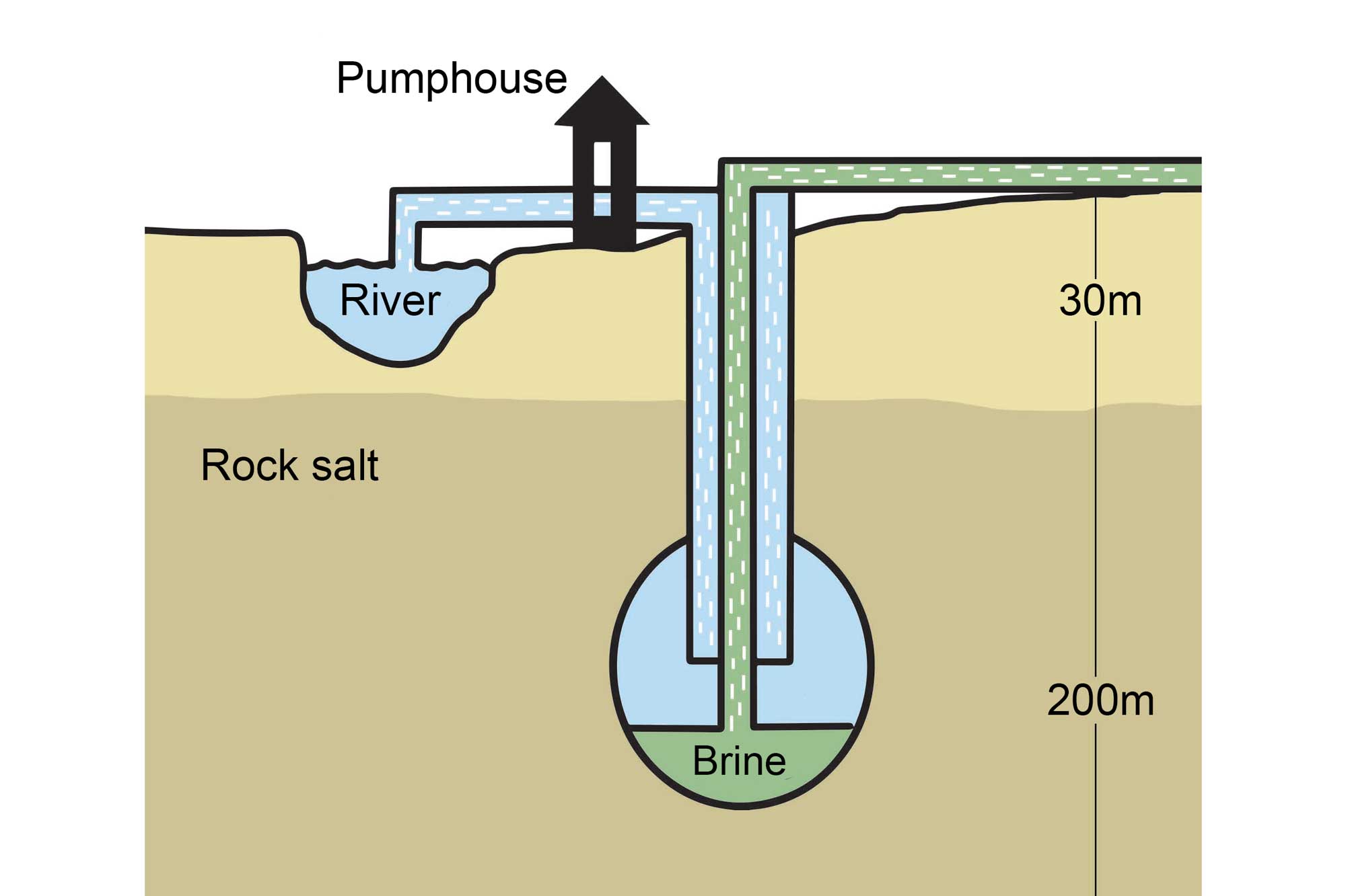
An example of solution mining that involves the pumping of fresh water through a borehole drilled into a subterranean salt deposit. Image by Wade Greenberg-Brand, adapted from image by the Salt Association and modified for the Earth@Home project.
Industrial and Other Minerals
The Great Plains region also produces numerous industrial minerals. These include sand and gravel, cement and lime, dimension stone, and leonardite, a mineral found in association with lignitic coals and used as a source of humic acid for agriculture and remediation of polluted water sources. Gravel, sand, and other construction materials are mined extensively throughout the Dakotas and Nebraska.
The gravels of the Great Plains’ streams and valleys, especially those of Montana, yield numerous gemstones. The origins of these stones, including one of Montana’s state gemstones, the Montana agate, lie in older igneous material worn down by Pleistocene glaciers and then redeposited as glacial sediments.
In addition, catlinite, a metamorphosed mudstone that is usually reddish in color and also known as “pipestone” or “pipe clay,” is found in the 1.7-billion-year-old Sioux Quartzite of southeastern South Dakota. This material has long been used by Native Americans and artists to make sacred pipes and sculptures.
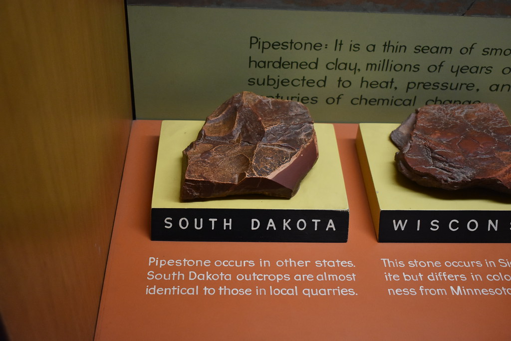
Sample of pipestone from South Dakota. Photograph by "JeromeG111" (Flickr; Creative Commons Attribution-NonCommercial-NoDerivs 2.0 Generic license).
Metals
Outcroppings of Proterozoic and Archean granites and metamorphic rocks in Wyoming’s Hartville Uplift are similar in nature to those found in the adjacent Laramie Mountains of the Southern Rockies, and are located on the divide that marks the northern end of the Denver Basin. Ores of tin (such as the simple oxide cassiterite, SnO₂), iron (as hematite), copper, silver, uranium, and gold were emplaced here through hydrothermal processes during the late Cretaceous to Paleogene periods.
Bipyramidal crystals of cassiterite (SnO2, tin oxide). Each crystal in the photo is approximately 30 millimeters (1.1 inches) across. Photograph by "Alchemist-hp" (Wikimedia Commons; Creative Commons Attribution-NonCommercial-NoDerivs 3.0 Unported license).
The Great Plains of Nebraska is home to the largest known deposit of the rare earth metal niobium, found near Elk Creek. Over 100 million tons of this heat-resistant element was emplaced here in a 545-million-year-old (late Precambrian) deposit of carbonatite (a type of a carbonate-rich igneous and volcanic rock), intruded into 1.8-billion-year-old metamorphic gneisses, schists, and granites. Niobium is often used in steel alloys, rocket engines,and the manufacture of superconducting materials, such as superconducting magnets for MRI scanners.
Economic deposits of uranium and vanadium are found in Paleocene and Eocene sediments of the southern Powder River Basin of Wyoming, and in the Oligocene rocks of northwest Nebraska at the Crow Butte mine. In 2013, extraction plants in Wyoming alone provided 81% of the nation’s total uranium production. The lignitic coals of North Dakota also contain significant uranium content, and economic quantities of uranium have been produced from these coals. Uranium is primarily used for nuclear power, while vanadium’s main use is in the production of specialty steel alloys.
Minerals of the Black Hills
The Black Hills of South Dakota and Wyoming represent an anomaly with respect to Great Plains physiography: they share their geologic history with the ranges of the Rocky Mountain region farther west, and thus are often considered to be the easternmost outpost of the Rockies. The Black Hills are an eroded, dome-shaped uplift that formed during the Laramide Orogeny, near the end of the Cretaceous or early Paleogene. Standing roughly 900 meters (3000 feet) above the rest of the Great Plains, they contain an exposed core of Archean and Proterozoic metamorphic, granitic, and pegmatitic rocks. The Archean rocks are approximately 2.5 to 2.7 billion years old, while the Proterozoic granites are roughly 1.7 billion years old. A sequence of sedimentary rocks, covering more than 400 million years of Earth’s history, is also exposed in these hills. Numerous mineral deposits occur in the Black Hills, the exploration and development of which led to the area’s settlement. In 1874, General George Armstrong Custer’s expedition discovered placer gold in Black Hills streams, just two years before the Battle of the Little Bighorn. Minerals containing gold, silver, molybdenum, tin, iron, copper, lead, uranium, vanadium, and rare earth elements are found in rocks ranging from Proterozoic through Quaternary in age.
Much of the gold produced in the Black Hills came from the Homestake Mine in Lead (pronounced “leed”), South Dakota, where it is found in late Cretaceous to Cenozoic veins that were intruded into early Proterozoic rocks during the Laramide Orogeny. Homestake was originally an underground mine that reached a depth of over 2400 meters (8000 feet), and it was once ranked as the deepest mine in the Western Hemisphere. Considered a “world-class” gold deposit, the mine was discovered in 1876 and sold in 1877 for the 2014 equivalent of $1.5 million dollars. It was later developed as an open pit operation.
The Homestake Mine, South Dakota, in 1900. Photochrom print by the Detroit Photographic Co., shared by "trialsanderrors" (Flickr; Creative Commons Attribution 2.0 Generic license). Compare with photograph at top of page.
Before its eventual closure in 2002, the Homestake Mine produced over 1.1 billion grams (40 million ounces) of gold—worth over $50 billion in today’s gold prices! Outside of the Homestake area, a number of Paleocene and Eocene-aged igneous intrusions occur in the northern Black Hills. These also carry gold, sometimes in commercial quantities.
On the northwestern edge of the Black Hills, deposits of thorium, a radioactive rare earth element, have been found in the Bear Lodge Mountains near the town of Sundance, Wyoming. These Eocene-aged deposits are intruded into Paleozoic and Mesozoic sedimentary rocks. Thorium is considered to be a “critical” rare earth element, meaning one in limited supply. It has potential applications in next-generation nuclear reactors that could be safer and more environmentally friendly than current uranium reactors.
The Black Hills are also well known for deposits of beryllium, lithium, tin, tungsten, and potassium-bearing minerals. These minerals are found in early Proterozoic pegmatites, some of which contain giant crystals of spodumene (lithium aluminum inosilicate).
Sample of spodumene from Hampshire Co., Massachusetts. 3D model by Harvard Library (Sketchfab).
Lithium is important to the manufacture of modern batteries, especially those used in computers, cell phones, and electric and hybrid vehicles.
Resources
Resources from the Paleontological Research Institution
Digital Atlas of Ancient Life: Minerals (collection of 3D models on Sketchfab): https://skfb.ly/6WxTo
Digital Encyclopedia of Earth Science: Minerals: https://earthathome.org/de/minerals/