

Page Snapshot: Introduction to Earth hazards in the midwestern United States.
Contents
Topics covered on this page: Earthquakes; Sinkholes; Radon; Floods; Weather hazards; Climate change; Resources.
Credits: Most of the text on this page comes from "Earth Hazards of the Midwestern US" by Nicole D. LaDue, chapter 10 in The Teacher Friendly Guide to the Earth Science of the Midwestern US, edited by Mark D. Lucas, Robert M. Ross, and Andrielle Swaby (published in 2014 by the Paleontological Research Institution). The book was adapted for the web by Elizabeth J. Hermsen and Jonathan R. Hendricks in 2022–2023. Changes include formatting and revisions to the text and images. Credits for individual images are given in figure captions.
Updates: Page last updated August 7, 2023.
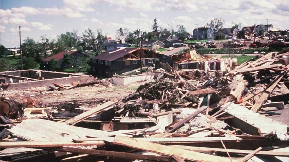
Image above: Near complete destruction of the town of Barneveld, Wisconsin resulted when an F5 tornado struck on June 8, 1984, resulting 9 deaths and 200 injuries.
Introduction
Natural hazards are events that result from natural processes and that have significant impacts on human beings. Extreme weather conditions or geologic activity can cause substantial short-term or long-term changes to our environment. These changes can influence crops, homes, infrastructure, and the atmosphere. The 4.6-billion-year-old Earth has experienced many of these natural changes, and it has always adjusted accordingly.
Most of the natural hazards in the Midwest are related to weather, geology, or some combination of the two. Examples of weather-related hazards include tornados (which cause a narrow path of extreme destruction) and long periods of unseasonably high temperature (which are a threat to crops and human health). Geologic hazards include events such as earthquakes, which can cause damage to housing, bridges, and roads. There is often little that can be done to prevent these natural events from occurring, but advanced planning can minimize their impact.
Earthquakes
While earthquakes usually bring California to mind, the New Madrid and Wabash seismic zones are responsible for earthquakes throughout the southern Midwest.
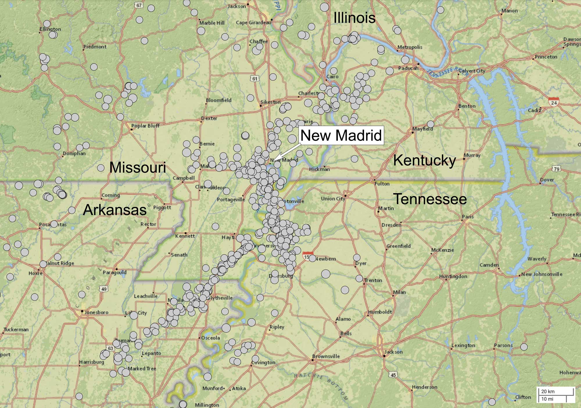
The epicenters of over 600 earthquakes of magnitude 2.5 or above recorded from the New Madrid seismic zone between the period of January 1, 1950 to February 22, 2022. Map created for the Earth@Home project using the USGS Earthquake Catalog (public domain).
The New Madrid seismic zone is in the Mississippi Valley, at the boundaries of Arkansas, Tennessee, Kentucky, Illinois, and Missouri. The Wabash Valley seismic zone extends northward along the boundary between Illinois and Indiana. These seismic zones are poorly understood because, unlike other seismic zones, there is nothing on the surface to help scientists understand the faults responsible for the seismic activity. For example, there is a thick layer of river-deposited sediments (called alluvium) that covers what is thought to be a strike slip fault. Microseismic earthquakes that are too small to be felt by humans happen every other day, but larger earthquakes are fairly rare. The bedrock that makes up most of the central US is colder, drier, and less fractured than rocks on the East or West Coast. As a result, the earthquakes here can release the same amount of energy as other earthquakes, but the shaking affects a much larger area because the seismic waves travel through denser, more solid bedrock.
Earthquake prediction is very difficult because most of the mechanisms that cause earthquakes are beneath the Earth’s surface. Scientists typically make use of historical records as well as limited surface monitoring to understand the probability of a seismic event occurring. Historical reports of earthquakes from 1811 to 1812 indicate a two-month period that included several major earthquakes thought to be greater than 7.0 in magnitude. Based on these historical reports, and the absence of a large magnitude earthquake in the past century, scientists expect that the New Madrid seismic zone is overdue for a large magnitude earthquake.
A new research study is likely to better explain the seismic activity of the Midwest. EarthScope is a large-scale project funded by the National Science Foundation to gather data about the lithosphere beneath the Earth’s surface. There are three large investigations of the seismic activity of this area. A network of 400 temporary seismometers has been installed, with a distance of approximately 70 kilometers (40 miles) between each seismometer. The volume of data collected by these seismometers will help geophysicists create three-dimensional models of the lithosphere. With these models, we will have a virtual picture of the seismic zones, and, hopefully, we will come to better understand the seismic hazards of the Midwest.
Karst and sinkholes
Sinkholes are usually caused by a geologic feature known as karst topography. Karst can form where the underlying bedrock is composed of material that can be slowly dissolved by water. Much of the Midwest has carbonate bedrock consisting of limestone, dolostone, and marble. These particular types of sedimentary rock contain significant amounts of carbonate (carbon atoms combined with multiple oxygen atoms). Water that mixes with carbon dioxide in the air and soil reacts to produce carbonic acid (H₂CO₃). This acid and the carbonate react, dissolving the rock. Although this takes a long time to occur, much of the bedrock in the Midwest is Paleozoic in age (between 541 million years and 252 million years old) (Figure 10.6).
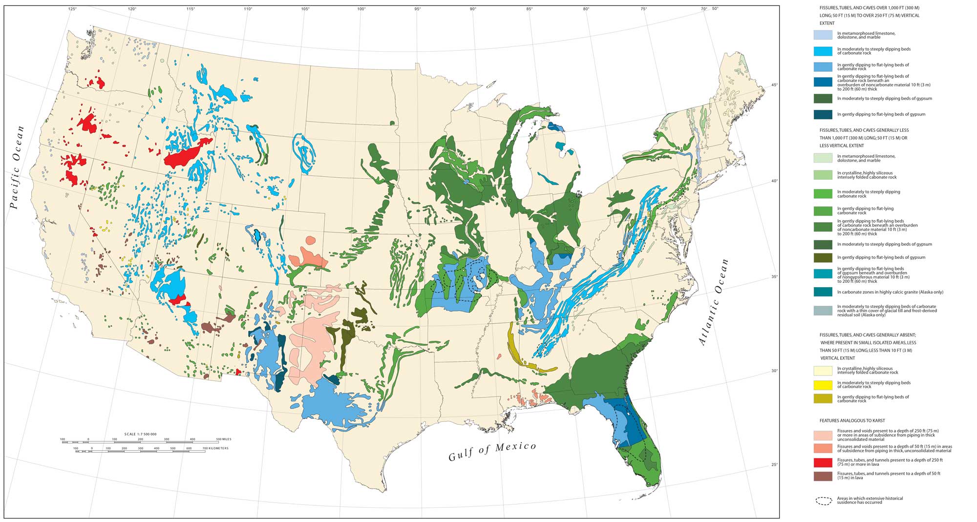
Karst topography in the continental United States. Image by USGS (public domain).
Eventually, caves and caverns form in the rock, and sinkholes form when caves near the surface collapse. The karst topography is noticeable in areas that contain many sinkholes and where the land surface is scattered with large, round depressions. There are a few conditions that increase the hazards associated with sinkholes.
The previously mentioned underground caves are often filled with groundwater. In regions where there is a rapidly growing population, a greater amount of water is extracted from the ground. Likewise, during periods of drought, the water table can drop considerably, leaving these caves filled with air instead of the water that would normally help to support the weight of the ground above. Without the support of the ground water, the surface can collapse. In some cases, increasing the weight on the surface by rapidly building large structures can also lead to sinkhole collapse. There are a few steps that can be taken to mitigate these issues. Geologists and environmental engineers can use ground-penetrating radar to identify the location of sinkholes. In some areas where sinkholes are very prevalent, engineers can fill the sinkholes with gravel, which will allow for water drainage while still supporting the surface.
Radon
Most of the Midwest has bedrock consisting of shale, sandstone, limestone, and dolostone, all of which can contain radon.
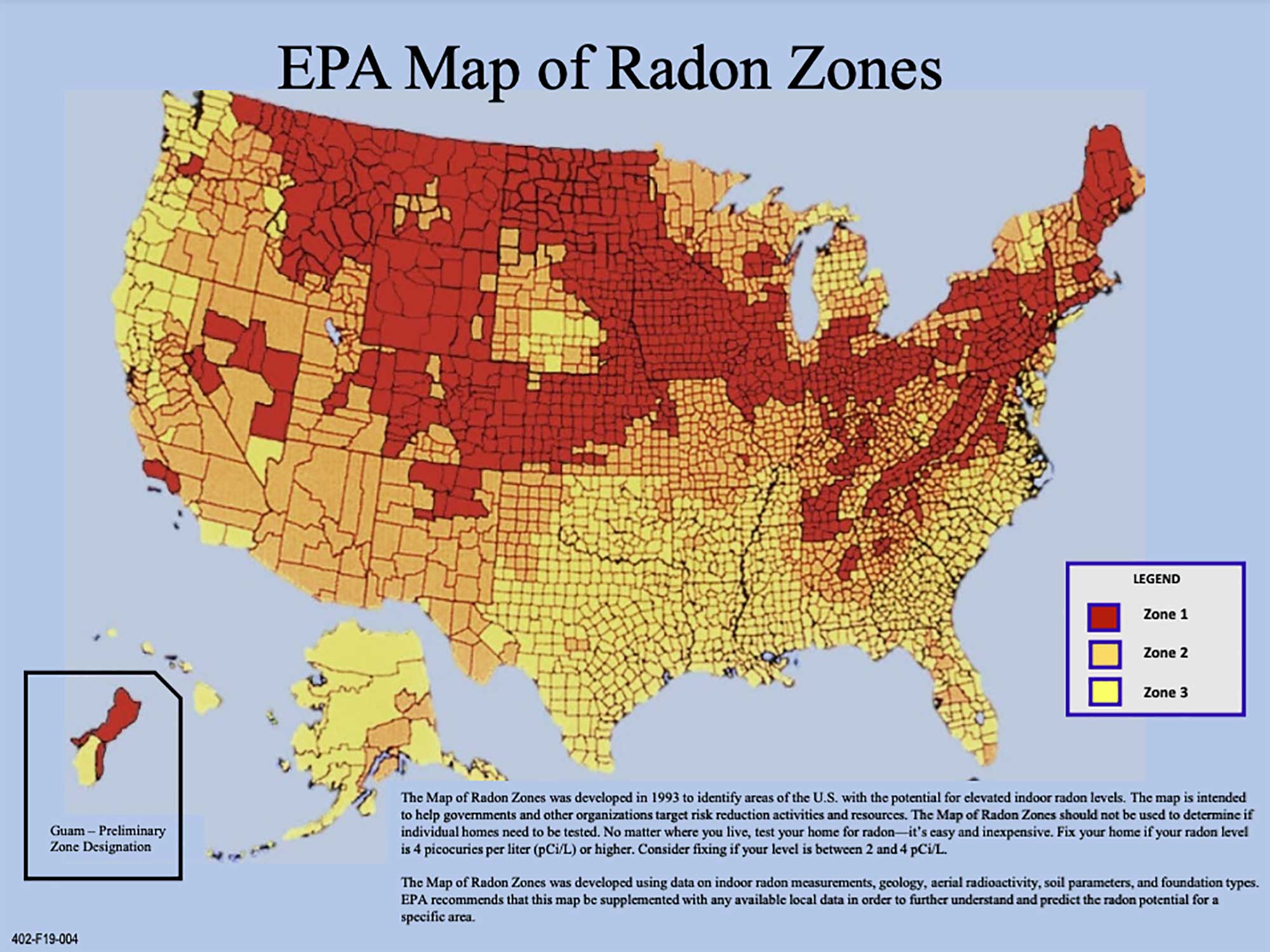
Map of radon zones in the United States (counties in red have the highest levels of radon). Image by the EPA (public domain).
Most of the northern Midwest has been substantially eroded from the glaciers of the Pleistocene. These glaciers left behind large deposits of gravel, sand, and clay as they receded and melted. The gravel, sand, and clay are often the eroded remnants of radon-containing bedrock, and the moist temperate climate of the Midwest provides an excellent environment for weathering of both the bedrock and the glacial sediments. As they weather, more rock is exposed, which, in turn, allows more radon to be released.
Floods
Flooding is a natural hazard resulting from the combination of geology and weather. The flat-lying bedrock of the Midwest and the large storm events create an ideal setting for flooding. Much of the southern and western boundaries of Midwestern states border the Mississippi and Ohio Rivers. Additionally, most of the waterways of the Midwestern states drain through the Upper Mississippi and Ohio River Basins (Figure 10.8).
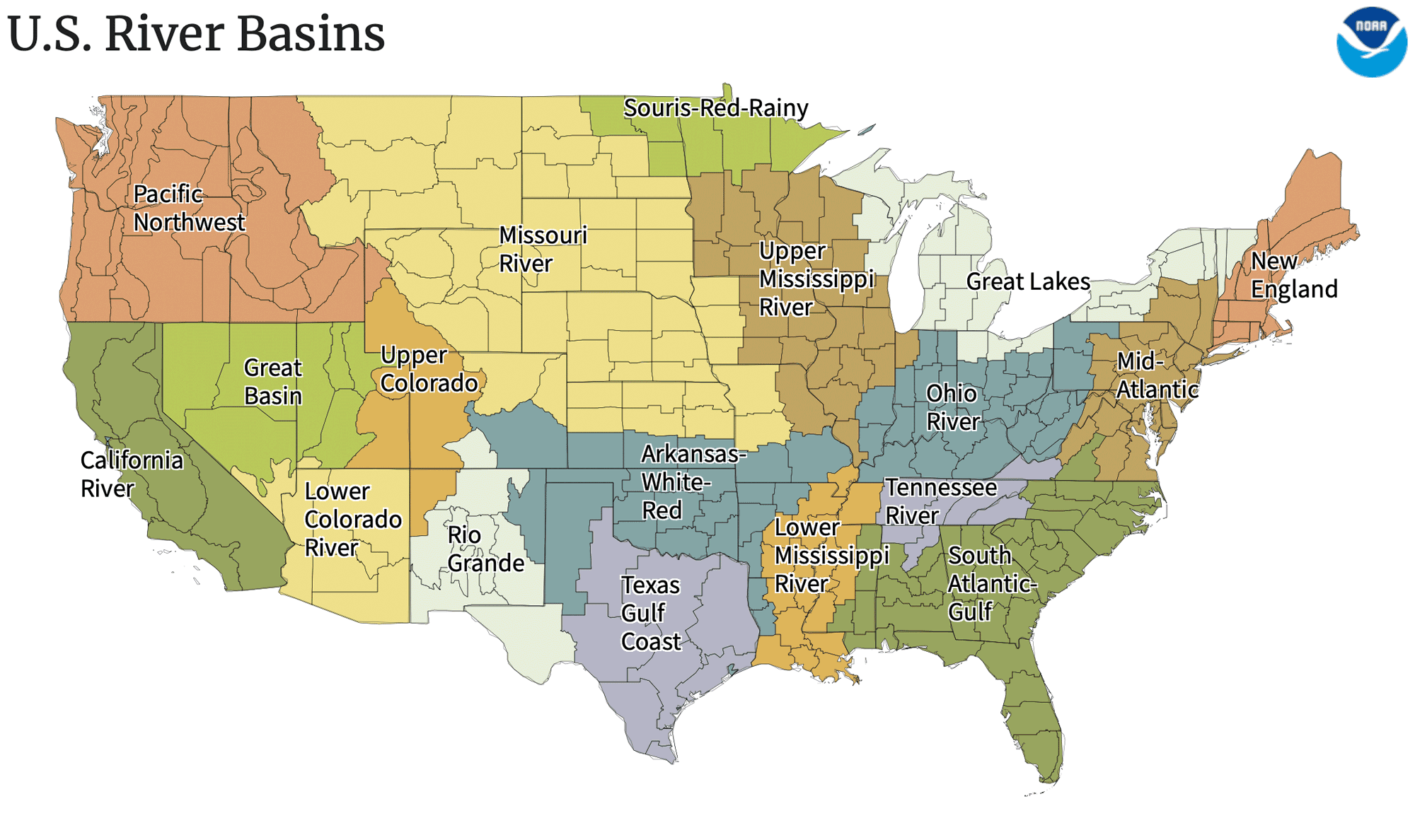
Major river basins of the continental United States. Map by NOAA (public domain).
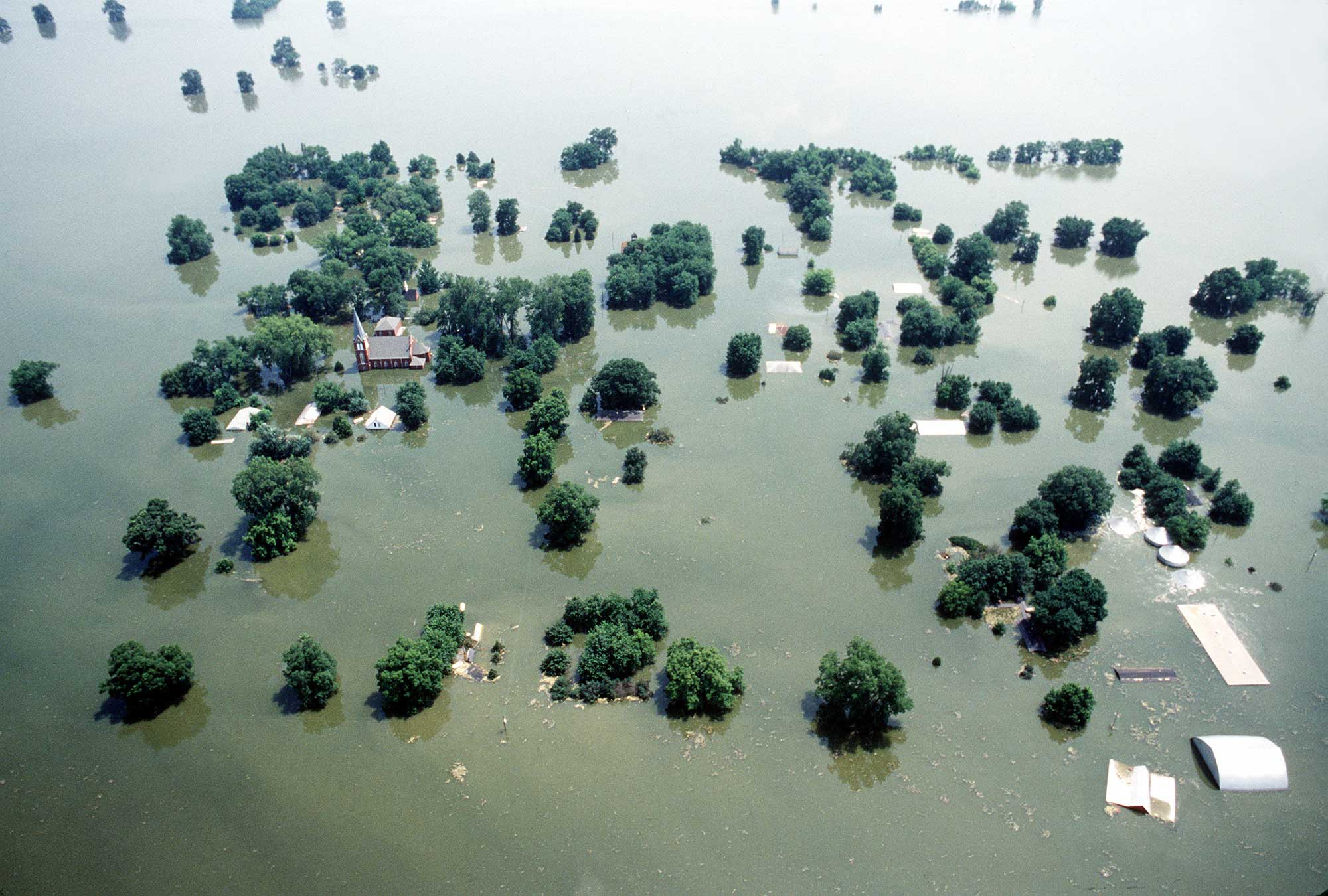
Kaskaskia, Illinois, during major flooding in 1993. Photo by SSgt Paul Griffin (Wikimedia Commons, public domain).
Weather hazards
While the Midwest is far from an ocean, it is near the Great Lakes; nevertheless, states in this area experience a considerable range of temperatures over the course of a year. The greatest temperature ranges are found during the winter: The average winter temperature of northern Minnesota is -13°C (8°F) while that of areas around the Ohio River is 2°C (35°F). Weather hazards can occur fairly frequently, such as several times a year, or relatively infrequently, such as once every century.
Storms
Several types of severe storms present challenges to people living in the Midwest. Summer brings severe thunderstorms associated with cold fronts. Fall and spring can bring ice storms. Winter brings the challenge of snow and, in some cases, blizzard conditions. Although rare, hurricanes moving north from the Gulf of Mexico can impact the weather in the Midwest as well. Severe thunderstorms are a common occurrence for people living in the Midwest because the conditions over the Great Plains are perfect for the development of severe weather. The flat, open fields are warmed by the summer sun, which sits high in the sky during this time of year. This results in large temperature differences when cold air masses move across the country.
Wind is very common in the Midwest, and the topography of the area plays an important role in wind formation, allowing for warm air to heat up over large expanses of flat cropland without hills or mountains to influence the direction of air movement. Therefore, the Midwest has the perfect ingredients for severe weather: flat topography and large temperature differences on a day-to-day basis.
While severe thunderstorms are a common occurrence in much of the Midwest, two less common storm hazards have the potential to cause serious property damage and endanger lives: derechos and tornados. Both storm events are associated with wind shear, which occurs when the wind speed or direction changes with increasing height in the atmosphere. Wind shear can happen when a cold front moves rapidly into an area with very warm air. There, the condensing water droplets mix with the cooler, drier air in the upper atmosphere to cause a downdraft. When these downdrafts are very powerful, they can cause a derecho, or a set of powerful straight-line winds that exceed 94 kilometers per hour (kph) (58 miles per hour [mph]) and can often approach 160 kph (100 mph). These powerful windstorms can travel over 400 kilometers (250 miles) and cause substantial wind damage, knocking down trees and causing widespread power outages. The lightning associated with these intense storms can cause both forest fires and house fires. Approximately one derecho every year or two will occur in much of the Midwest.
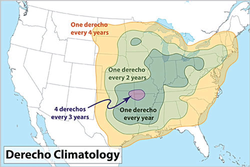
Derecho frequency in the continental U.S. Image from NOAA (public domain).
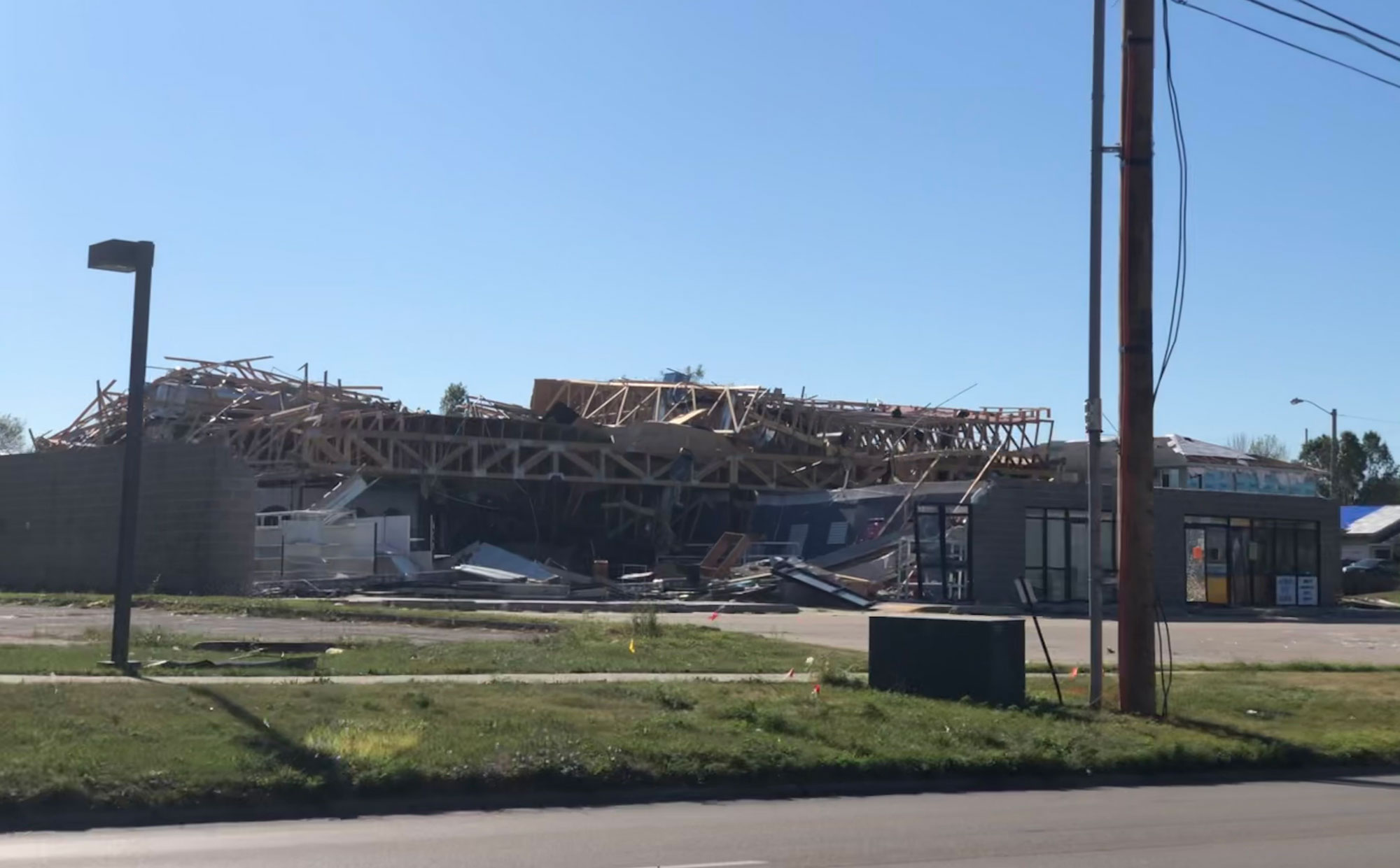
Photograph of Wiley Plaza, Cedar Rapids, Iowa, after it was damaged by a derecho in August 2020. Photo by Found-Verdict (Wikimedia Commons, Creative Commons Attribution-ShareAlike 4.0 International license, image cropped and resized).
They are less frequent in the upper Midwest states, which remain cooler throughout the summers. The differences between tornadoes and derechos are indicated in their names: the word derecho is the Spanish word for straight ahead, while the word tornado has its roots in the Spanish word tonar, which means to turn. Both types of storm events can be associated with the same major cold front boundary because they require similar ingredients to get started.
Hurricanes
Hurricanes do not form in the Midwest. However, if a hurricane is particularly strong, it can move far enough northward and inland to cause a significant rain event for areas in the Midwest. The impact on the Midwest is usually less serious than the property damage experienced along the southern and eastern seaboards of the United States. Natural hazards experienced during a hurricane are similar to those experienced during a severe thunderstorm that is accompanied by flooding.
Extreme Temperature
In 1995, a heat wave impacted the Midwest, leading to nearly 740 heat-related deaths in Chicago alone. In addition to causing widespread illness from dehydration and exposure to extreme heat, the high temperatures buckled road pavement and warped train rails.
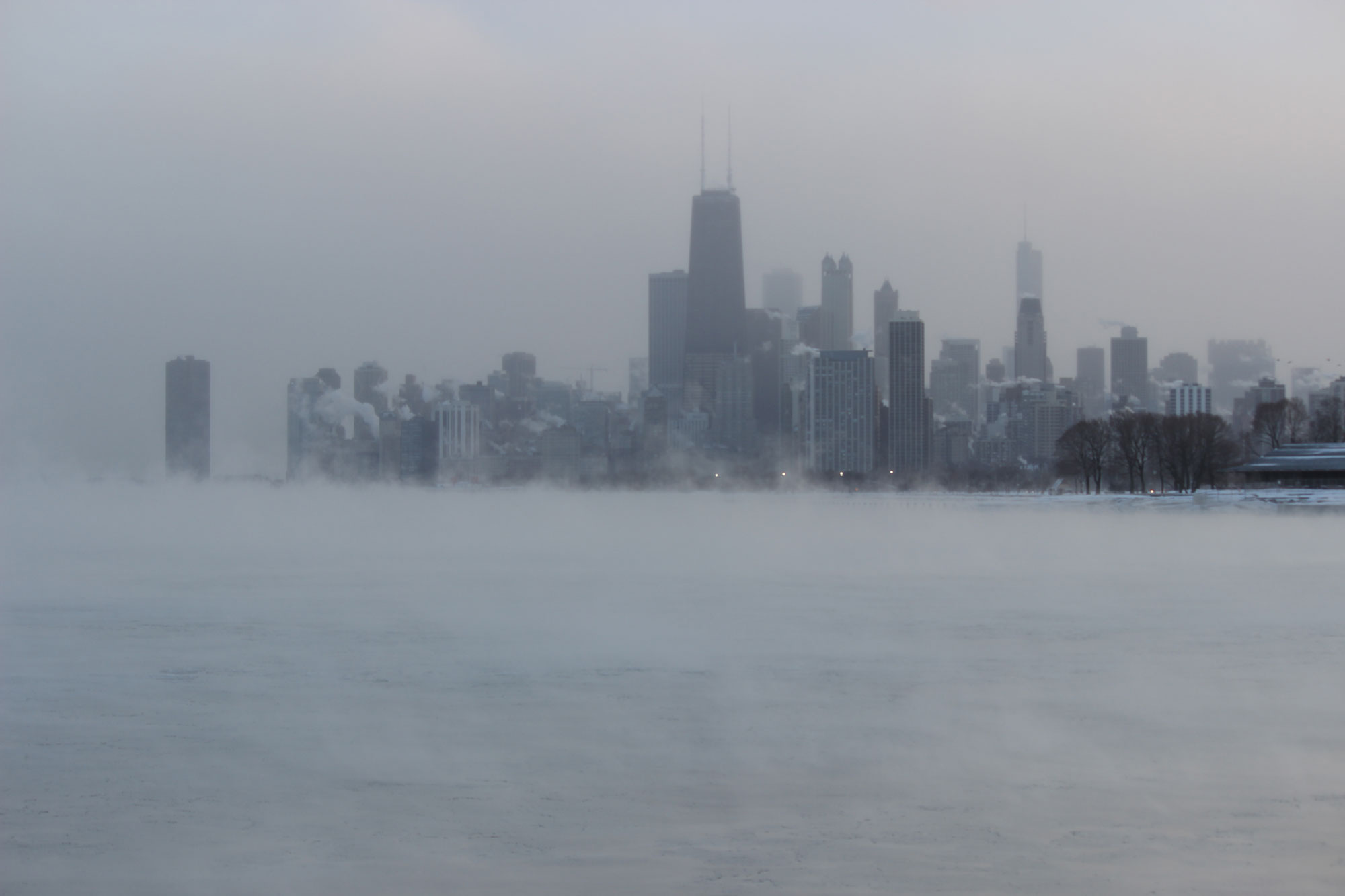
Recently, a different extreme temperature phenomenon has made the news: the polar vortex. As the name implies, a polar vortex is a regularly occurring area of low pressure that circulates in the highest levels of the upper atmosphere. Typically, the polar vortex hovers above Canada. However, a pocket of the counter-clockwise rotating low-pressure center can break off and shift southward at a lower altitude, covering the Midwest with frigid air. The jet stream then shifts to a more southward flow than usual, chilling the Midwest and even the southern states. A polar vortex can lock the jet stream in this new pattern for several days to more than a week. Extreme low temperatures can endanger livestock, and precautions should be taken regarding travel on roadways. Although the cold temperatures of a polar vortex can be uncomfortable and make traveling dangerous in the winter, the Midwest has not yet experienced any major economic or health-related impacts from this extreme weather event.
Satellite image showing the Great Lakes region of the United States and Canada during a polar vortex, January 27, 2019. The streaks of snow coming off the Great Lakes are "cloud streets" indicative of lake effect snow. Source: NASA Earth Observatory image by Josh Stevens (used following NASA's image use policy).
Chicago, Illinois, during a polar vortex in 2014. Photo by edward stojakovic (flickr, Creative Commons Attribution 2.0 Generic license, image resized).
Climate change
With the earlier definitions of weather and climate in mind, it is important to understand that most of the extreme climate change in Earth’s history occurred before humans existed. That being said, the rapid release of carbon dioxide into the atmosphere from human activity is causing a global warming event. The seemingly slight increase in the average annual temperatures in the Midwest has been accompanied by more frequent heat waves and shorter winters. In addition to the previously mentioned risks associated with heat waves, increasing temperatures allow for certain bugs, such as ticks and mosquitoes, to live longer, thereby increasing the risk of contracting the diseases they carry. Heat waves can also be associated with droughts that hurt crop production.
In contrast, scientists are predicting more severe rainfall events in the Midwest in the coming years. This has recently resulted in an increase in severe flooding, damage to infrastructure, and even death. While the coexistence of these two types of events may seem contradictory, it is indicative of an increase in extreme events overall. Ultimately, the Midwest, unlike the coastal US states, should be able to more easily endure the effects of climate change because of its considerable distance from an ocean that would be subjected to rising sea levels. Humans have designed and built air conditioning and heating systems for protection from extreme weather. The crops, fish, and livestock, upon which humans depend for food, however, live without these climate control systems, and will therefore experience the impacts of environmental changes more directly. Increasing temperatures and changes in rainfall patterns will alter the type of crops that can be successfully grown and harvested across the Midwest.
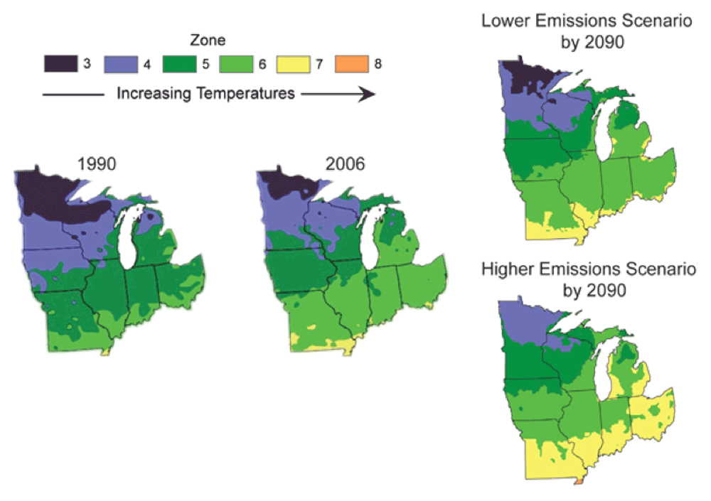
Shifts in USDA Hardiness Zones as a result of climate change. Image from the U.S. Global Change Research Program.
Models have predicted that the climate of Midwestern states, such as Michigan and Illinois, will be more similar to the current climate of Texas by the end of the 21st century.
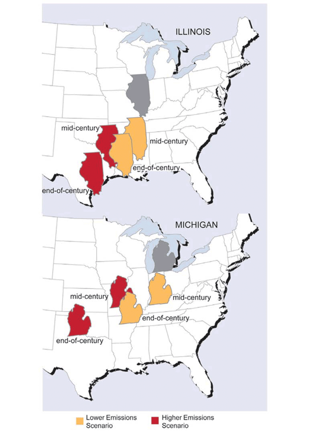
Prediction of the relative climates for Illinois and Michigan’s Lower Peninsula due to climate change. Image from the U.S. Global Change Research Program.
Another concern regarding hazards exacerbated by climate change in the Midwest is whether or not there has been or will be an increase in the number or the severity of storms, such as hurricanes and tornadoes. According to NASA, the present data is inconclusive in terms of whether the Atlantic Ocean hurricanes are already more severe, but there is a greater than 66% chance that global warming will cause more intense hurricanes in the 21st century. Since tornados are hard to predict, involve a complex mix of atmospheric conditions, and occur on a much smaller geographic scale than hurricanes do, it is difficult to determine if global warming is currently influencing the frequency or severity of tornado activity. Since climate is weather averaged over decades, it might take many years to determine that a change has occurred with respect to these two types of storms. Scientists are certain that the conditions necessary to form such storms are becoming more favorable due to global warming.