

Page snapshot: Introduction to glaciers of the northeastern United States.
Topics covered on this page: Introduction; From the Pleistocene to the present; Rebounding of the crust; Glacial scouring; Potholes; Alpine cirques; The Great Lakes; Champlain Sea; Glacial Lake Albany; Pleistocene glacial deposits; Drumlins and moraines in the Central Lowland and Inland Basin regions; Drumlins and moraines in the Exotic Terrane region; Cape Cod and off-shore islands; Kettle lakes; Eskers; Resources.
Credits: Most of the text on this page comes from the The Teacher-Friendly Guide to the Geology of the Northeastern U.S. by J. E. Ansley (published in 2000 by the Paleontological Research Institution, reprinted in 2016; currently out of print). The book was adapted for the web by Elizabeth J. Hermsen and Jonathan R. Hendricks in 2022. Changes include formatting and revisions to the text and images. Credits for individual images are given in figure captions.
Updates: Page last updated October 6, 2022.
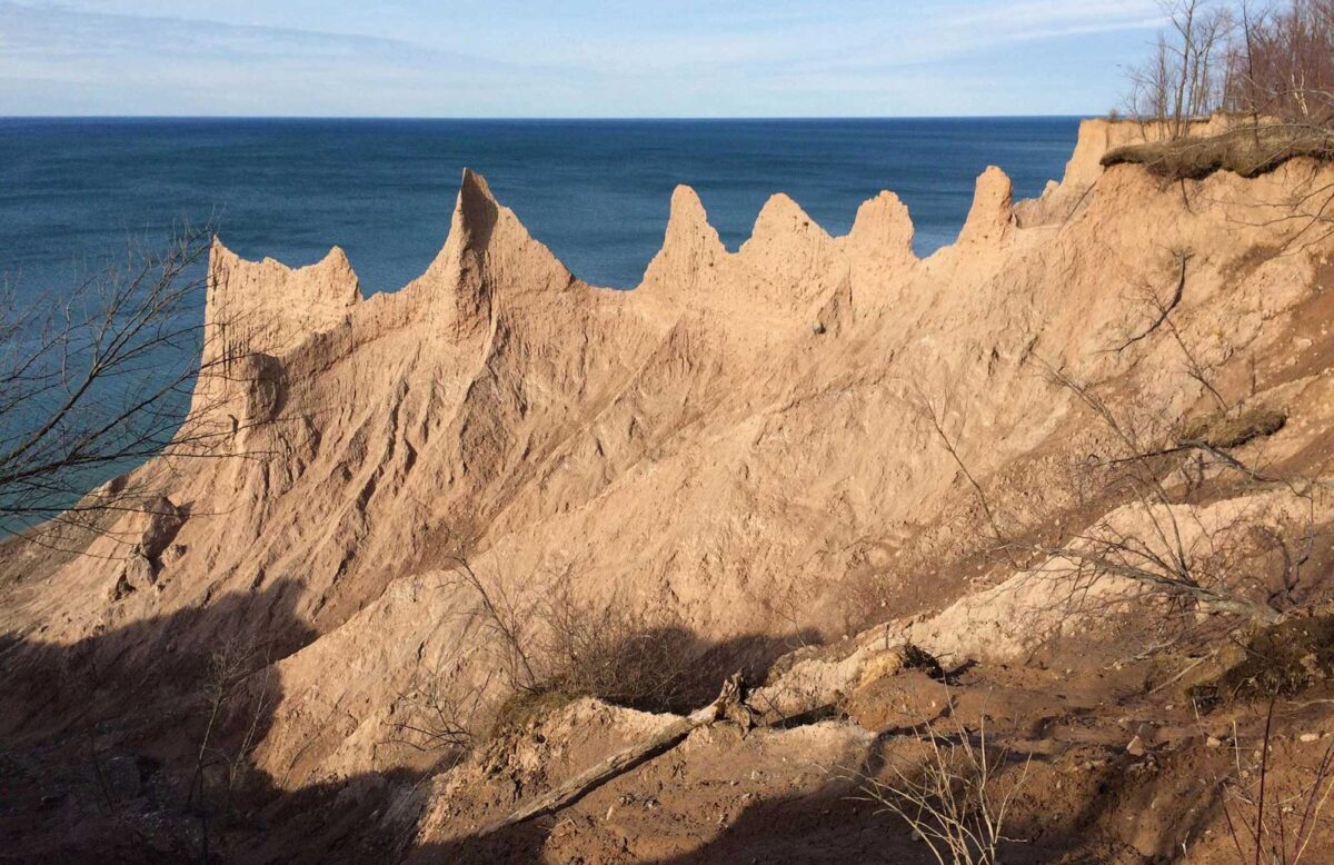
Image above: Eroded drumlin sediments on the south shore of lake Ontario, Chimney Bluffs State Park, New York. Photo by Andre Carrotflower (Wikimedia Commons, Creative Commons Attribution-ShareAlike 4.0 International license, image cropped and resized).
Introduction
The Quaternary period began 1.8 million years ago and was marked by a series of advances and retreats of successive enormous ice sheets that originated in the Hudson Bay area of Canada. The Quaternary period is divided into two epochs: the Pleistocene and Holocene. The Pleistocene is simply the equivalent of the Quaternary minus the most recent (and current) interglacial interval, the Holocene. Ice age conditions existed when the ice sheet advanced over the North American continent; interglacial or warming periods existed when the ice sheet retreated north. Advances of the ice sheet over the northern United States occurred several dozen times over the course of the Pleistocene epoch of the Quaternary.
Although not all of the Northeast was covered by the ice sheet, the entire region felt its effects. The region covered by the ice sheet was scoured and covered with glacial deposits; the region south of the ice sheet has its own distinctive landscape and features because it was next to the ice margin.
Extent of glaciation over North America at the Last Glacial Maximum. Image adapted from map by the USGS (public domain).
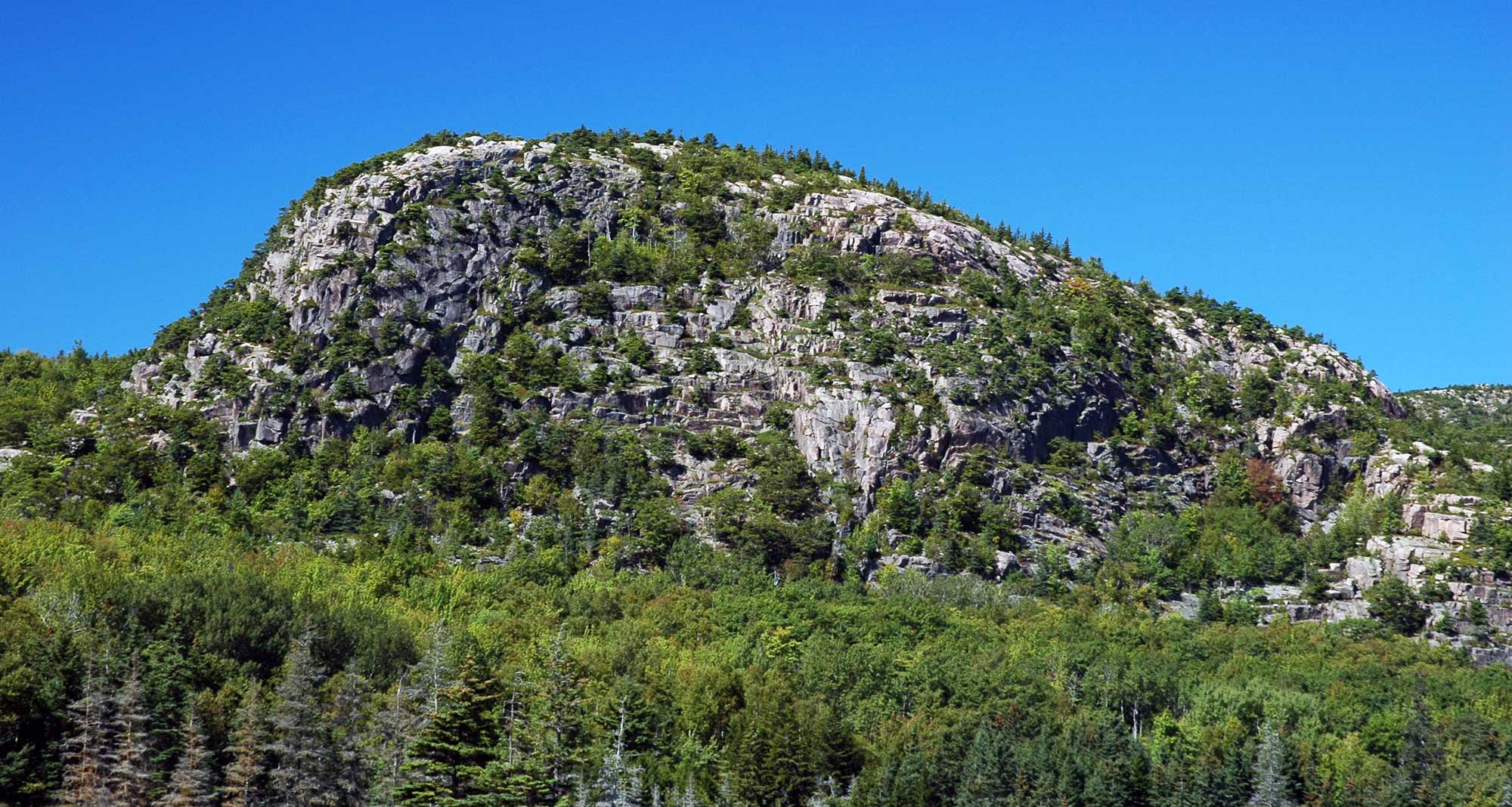
The Beehive, a glacially shaped rock formation (roche moutonnée), Acadia National Park, Maine. The granite that makes up the Beehive dates to near the Silurian-Devonian boundary. Photograph by James St. John (flickr, Creative Commons Attribution 2.0 Generic license, image cropped and resized).
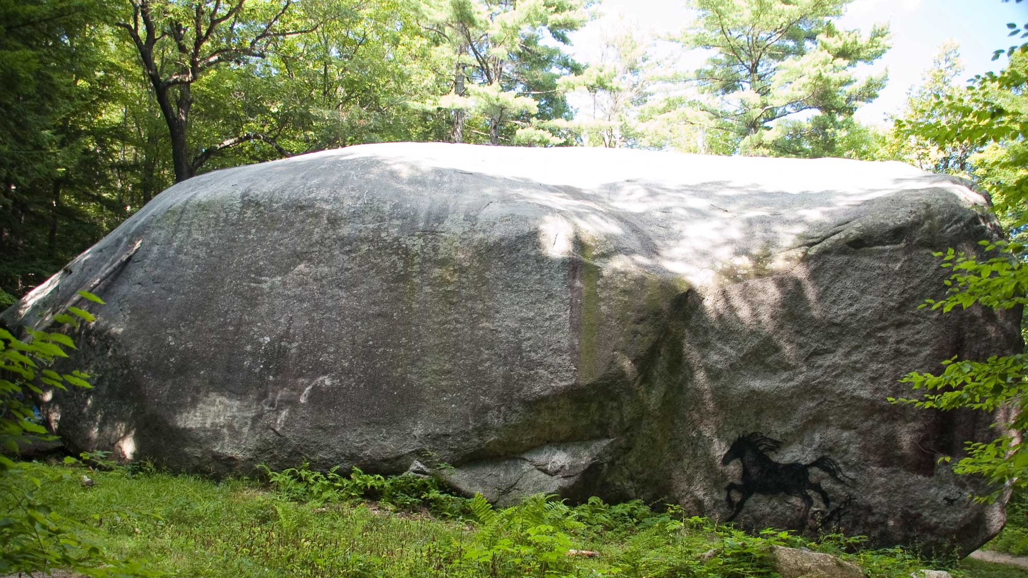
The Madison Boulder, a large glacial erratic, Wayside Geological Park, Madison, New Hampshire. Photograph by stannate (flickr, Creative Commons Attribution-ShareAlike 2.0 Generic license, image resized).
From the Pleistocene to the Present
Before the Pleistocene began, cooling climate triggered the start of a series of glacial advances. During the Pleistocene, there were several dozen intervals of glaciation separated by warmer interglacial intervals characterized by glacial retreat. In North America, these cycles are known as the pre-Illinoian (1.8 million–302,000 years ago, including glacial and interglacial stages), Illinoian glaciation (191,000–131,000 years ago), Sangamonian interglacial (131,000–85,000 years ago), and Wisconsinian glaciation (85,000–11,000 years ago).
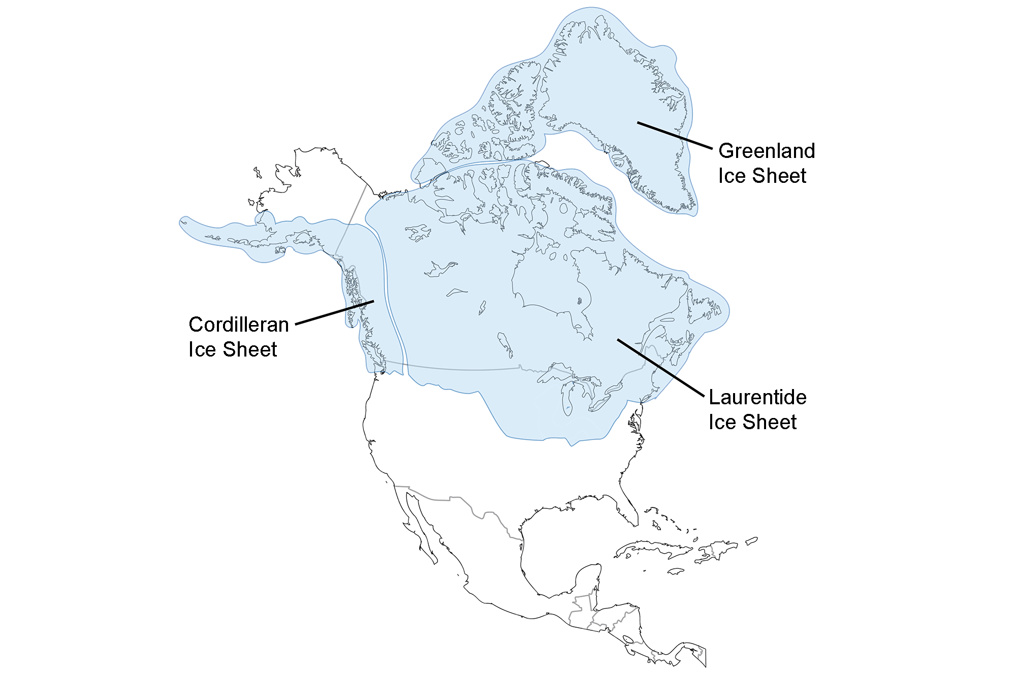
The most recent glacial period began 85,000 years ago. It affected the Northeast until about 10,000 years ago. Ice spread from a single dome located in northern Canada over the Hudson Bay and eventually covered much of the Northeast. Approximately 20,000 years ago, this ice sheet reached its maximum extent, reaching as far south as Long Island and northern New Jersey and Pennsylvania.
Marks left behind by the glaciers on the high peaks of the Adirondacks and New England mountains tell us that the glaciers covered the tallest peaks in the Northeast, reaching a thickness of between one and two kilometers (0.6 to 1.2 miles). Even during this time of glacial advance, however, the ice sheet was always melting at its fringes, shaping the landscape at the glacial front (known as the periglacial zone).
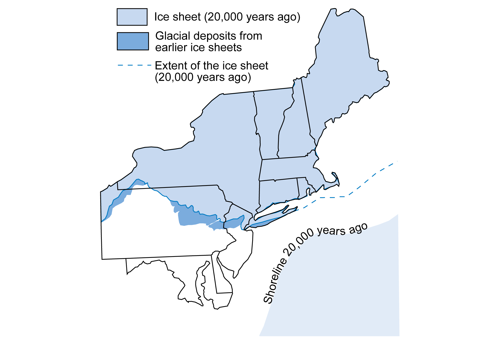
The approximate position of the ice sheet (light blue shading and blue line) about 20,000 years ago in the northeastern U.S. Medium blue areas are regions that were covered by earlier glacial deposits. Modified from figure 3.5 in The Teacher-Friendly Guide to the Geology of the Northeastern U.S. by J. E. Ansley (published in 2000 by the Paleontological Research Institution, reprinted in 2016).
Glacial striations on dolomite, Chittenden County, Vermont. Photo by James St. John (flickr, Creative Commons Attribution 2.0 Generic license, image resized).
By 18,000 years ago, the climate warmed, causing the the ice sheet to begin to retreat. During this time of glacial retreat, the ice sheet was not actually flowing backwards; the glacier continued to flow forward, but it was melting faster than it was advancing. Thus, while the ice sheet alternately moved forward and melted backward during its retreat, its overall movement was backward. Moraine deposits mark the extent of glacial advance in the Northeast.
As glaciers melted, sea level rose. By 14,000 years ago, sea level had risen so high that the ocean flooded the St. Lawrence River. The formation of the St. Lawrence Seaway cut off the glacial ice that covered much of Maine. Continued melting left the Northeast free from the ice sheet about 10,000 years ago.
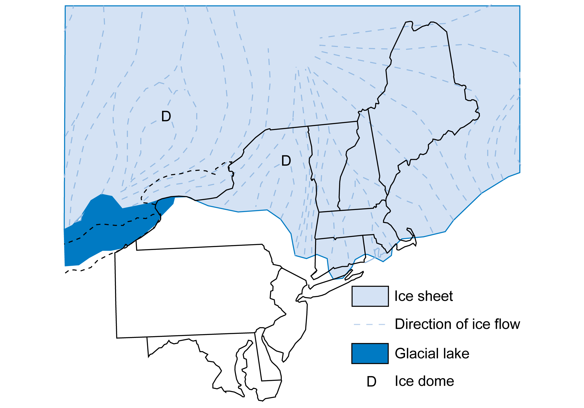
The northeastern U.S. 18,000 years ago. Dark blue areas are glacial lakes, and light blue areas are areas that were covered by the continental ice sheet. Ice domes are indicated by the letter "D." Modified from figure 3.6 in The Teacher-Friendly Guide to the Geology of the Northeastern U.S. by J. E. Ansley (published in 2000 by the Paleontological Research Institution, reprinted in 2016).
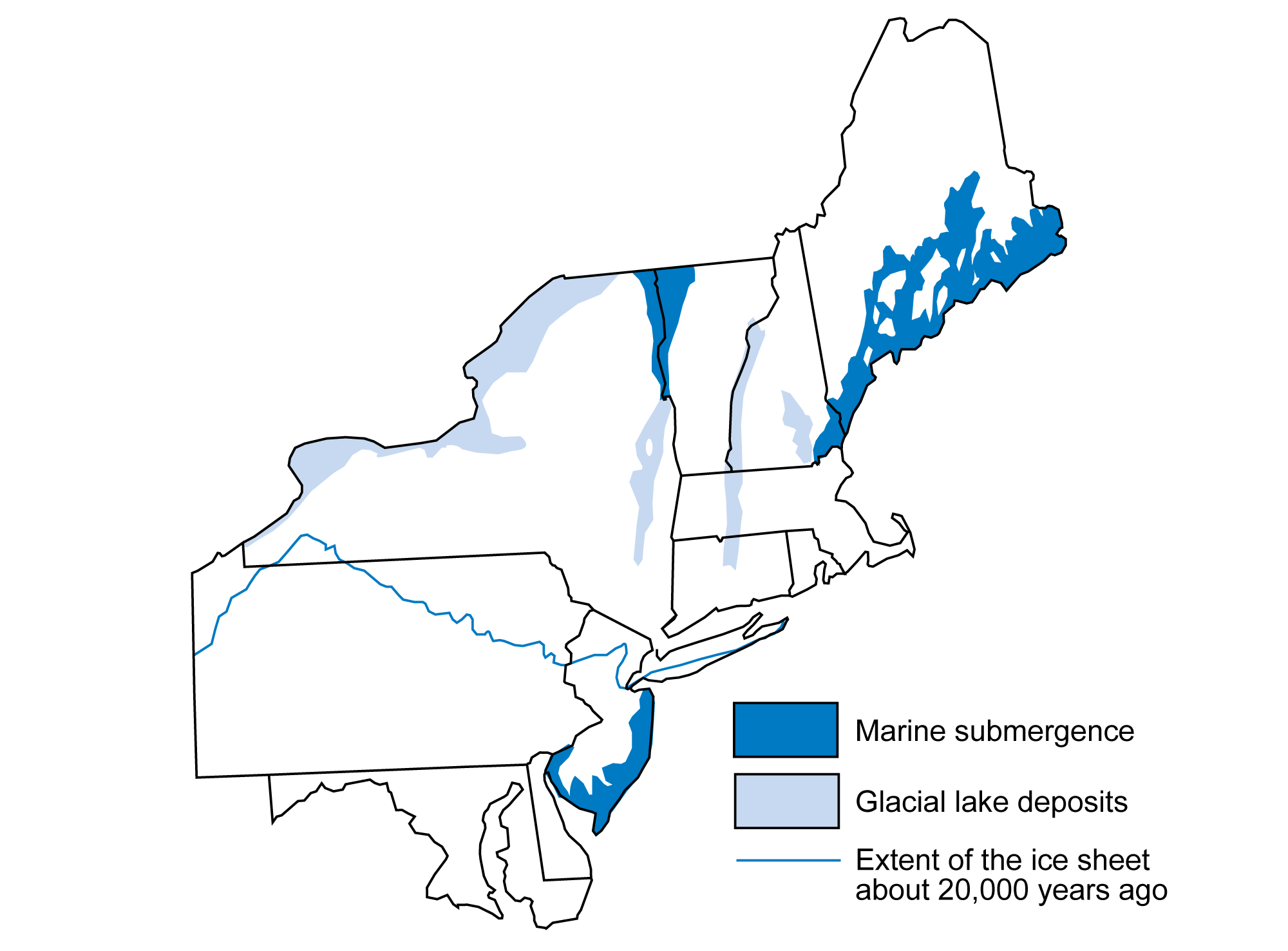
The northeastern U.S. 12,000 years ago. Dark blue areas are regions that were covered by seawater, and light blue areas are areas that were submerged beneath glacial lakes. The maximum position of the ice sheet about 20,000 years ago is marked by the blue line. Modified from figure 3.7 in The Teacher-Friendly Guide to the Geology of the Northeastern U.S. by J. E. Ansley (published in 2000 by the Paleontological Research Institution, reprinted in 2016).
Rebounding of the crust
The Pleistocene ice sheets could exceed two kilometers (1.2 miles) in thickness. The enormous weight of all of that ice over the continent depressed the crust into the asthenosphere (the uppermost part of the mantle), just as the weight of a person in a canoe causes the boat to ride lower in the water. When the person steps out of the canoe, the buoyancy of the canoe allows it to once again rise.
As the ice sheet retreated from the Northeast during the current interglacial period, the crust rebounded, and it continues to do so today. As the ice sheet began to retreat northwards, sea level rose faster than the crust was able to rebound from the weight of the glaciers. The result was a dramatic change in the shoreline of the Northeast, from one in which the continental shelf was exposed or covered by ice to one in which the shelf was under water.
During this period of retreat, the coast even more covered by sea water in some places than it is presently. The whole coast of Maine, for example, was flooded beyond its present shoreline, leaving a blanket of clay deposited by the ocean waters inland and along the present day coast. The clays are known as the Presumpscot Formation, filled with a variety of fossil marine organisms that are clear evidence of the marine submergence.
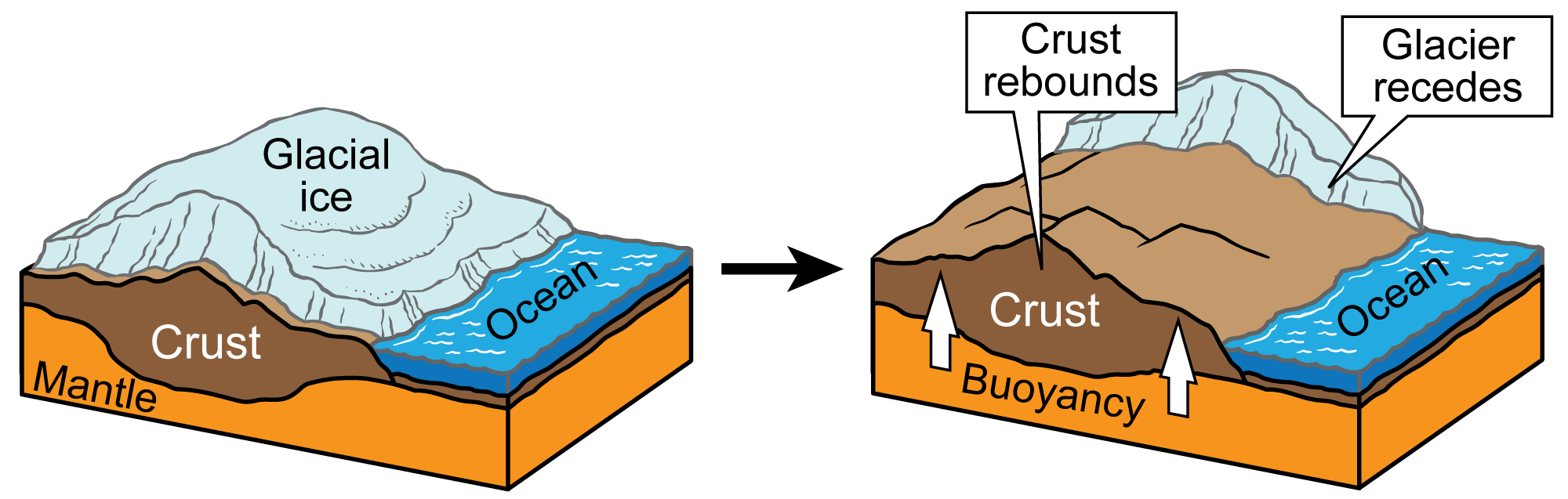
As dense glacial ice piles up, a glacier is formed. The ice begins to move under its own weight and pressure. Through isostacy, glaciers push the crust down, and, when they melt, the crust rebounds upward. Image by Jim Houghton; modified for the Earth@Home project.
Glacial scouring
Potholes
Glacial scouring, resulting from the scraping action of the glacial sediments, have formed two classic glacial features in the Northeast: potholes and lake basins. Archbald Pothole State Park near Scranton, Pennsylvania is one of the largest glacier-scoured potholes in the world, measuring approximately 13 meters wide and 12 meters deep. While not always caused by glacial runoff, smaller potholes are found throughout the once glaciated areas of the Northeast.
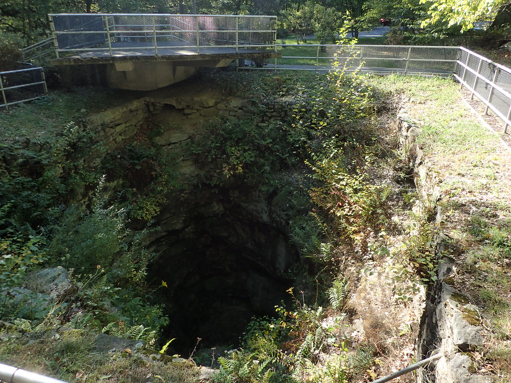
Archbald Pothole State Park, Pennsylvania. Photo by Robot Brainz (flickr, Creative Commons Attribution-NonCommercial-NoDerivs 2.0 Generic license).
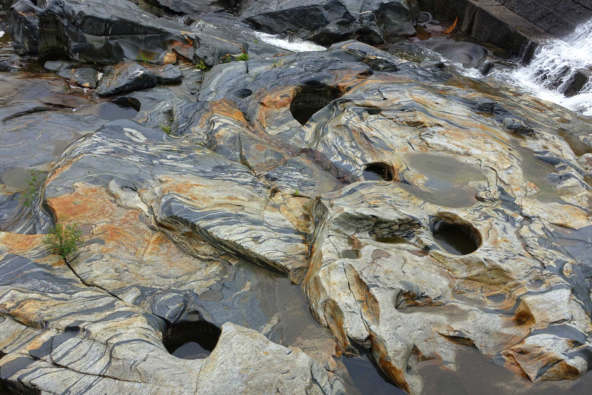
Glacial potholes in gneiss at Shelburne Falls, Massachusetts. Photo by Daderot (Wikimedia Commons, CC0 1.0 Universal/public domain dedication).
Alpine cirques
The most evident glacial scour features in the Exotic Terrane region are cirques, scoop-shape bowls where valley glaciers have originated at high altitudes. At Mt. Washington in New Hampshire, and Sugarloaf Mountain, Mt. Katahdin and other Baxter Park peaks in Maine, cirques are visible today. The intense erosion by the glaciers removed many meters of bedrock from the New England mountains.
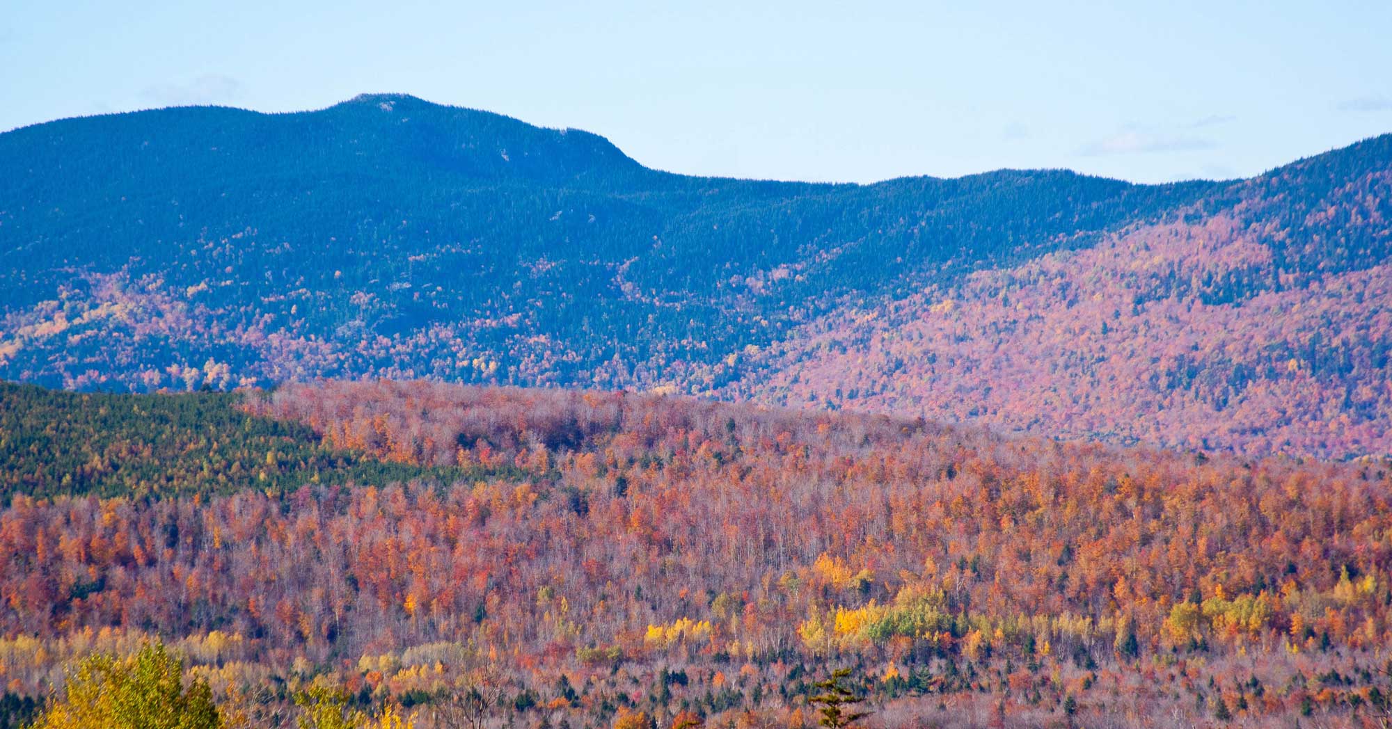
Sugarloaf Mountain, Maine. Photo by Paul VanDerWerf (flickr, Creative Commons Attribution 2.0 Generic license, image cropped and resized).
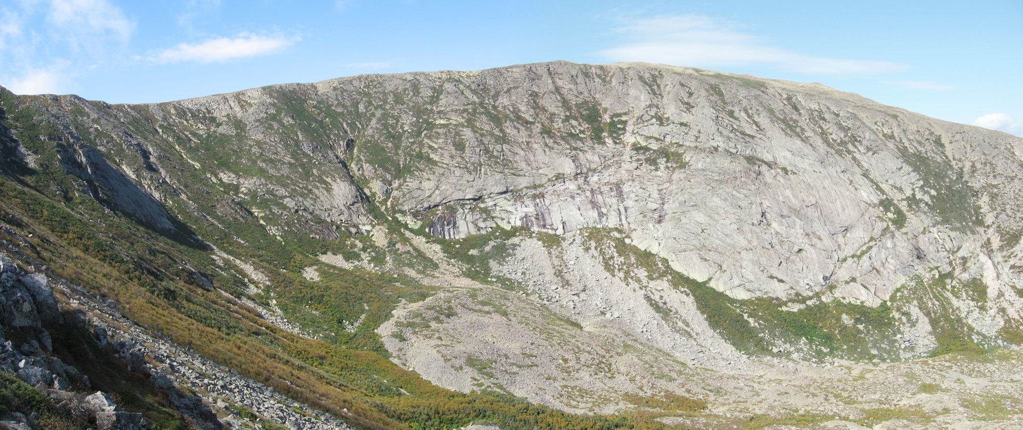
North Basin, a glacial cirque on Mt. Katahdin, Baxter State Park, Maine. Photo by Fredlyfish4 (Wikimedia Commons, Creative Commons Attribution-ShareAlike 4.0 International license, image resized).
The Great Lakes
A mere 20,000 years ago, the Great Lakes did not exist. At that time, the ice sheets extended well past where the lakes would now occur. The Great Lakes were actually river valleys that were scoured and deepened repeatedly by the numerous ice advances during the Quaternary period. As the glacier retreated and the basins filled with glacial runoff, the still-forming lakes drained southward, eventually into the Mississippi River.
The broad, deep basins of Lakes Ontario and Erie, former river valleys, were scooped out by tongues of ice as the glacier advanced over North America. When the glacier began its retreat, meltwater flooded lake basins. Lakes Ontario and Erie were both much larger than today. Glacial meltwater poured into these basins, and the ice blocked drainage that would eventually flow to the northeast via the St. Lawrence River. The Erie and Ontario Lowlands, as well as the once-flooded Mohawk River Valley south of the Adirondacks, are the remains of the much larger lakes. Flat, lowland topography and characteristic lake bottom sediments are found in the areas where the lakes once reached.
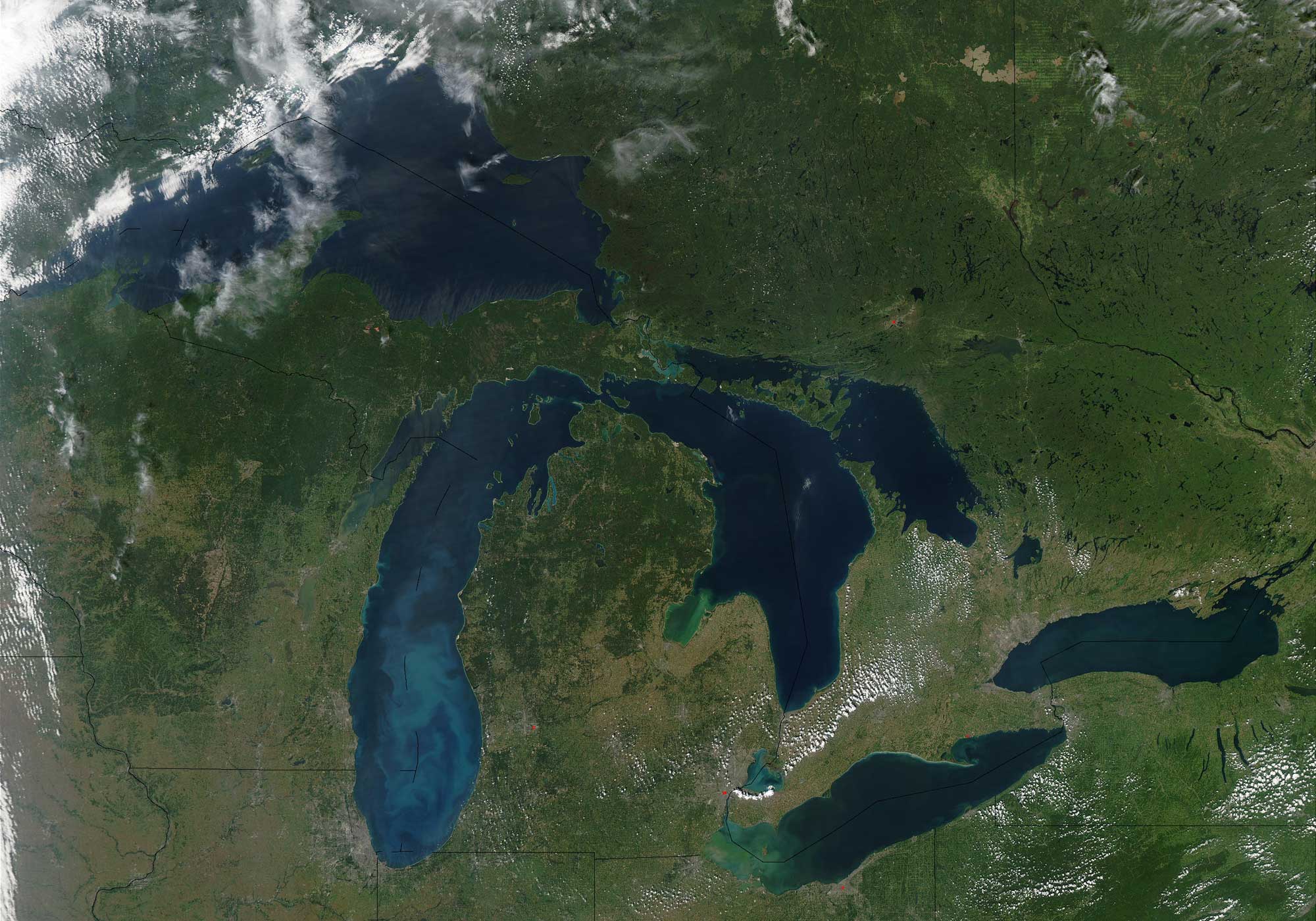
Satellite image of the Great Lakes region of North America. Photo by Jeff Schmaltz, MODIS Rapid Response Team, NASA/GSFC (NASA Visible Earth, used following NASA's image use policy).

Diagram showing the relative elevations and depths of the Great Lakes. Source: NOAA (NOAA Great Lakes Environmental Research Laboratory on flickr, Creative Commons Attribution-ShareAlike 2.0 Generic license).
The Finger Lakes
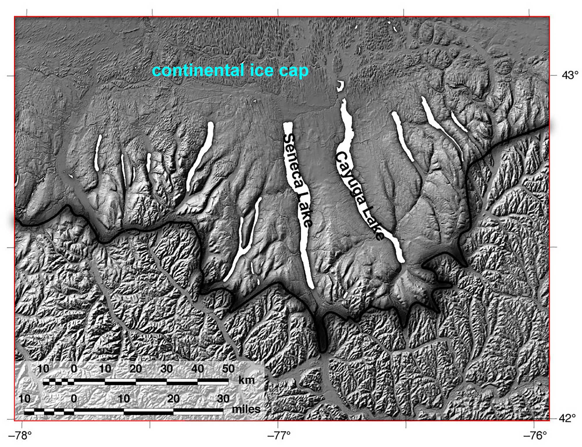
The Finger Lakes were pre-existing river valleys before the tongues of ice covered the area and widened and deepened the valleys. The stream valleys were dammed at their southern end by glacial till and flooded to form the Finger Lakes when the ice sheet retreated. Whereas streams only erode as far down as sea level, glaciers are able to erode more deeply. The bottoms of two of the Finger Lakes (Lakes Seneca and Cayuga) are actually below sea level.
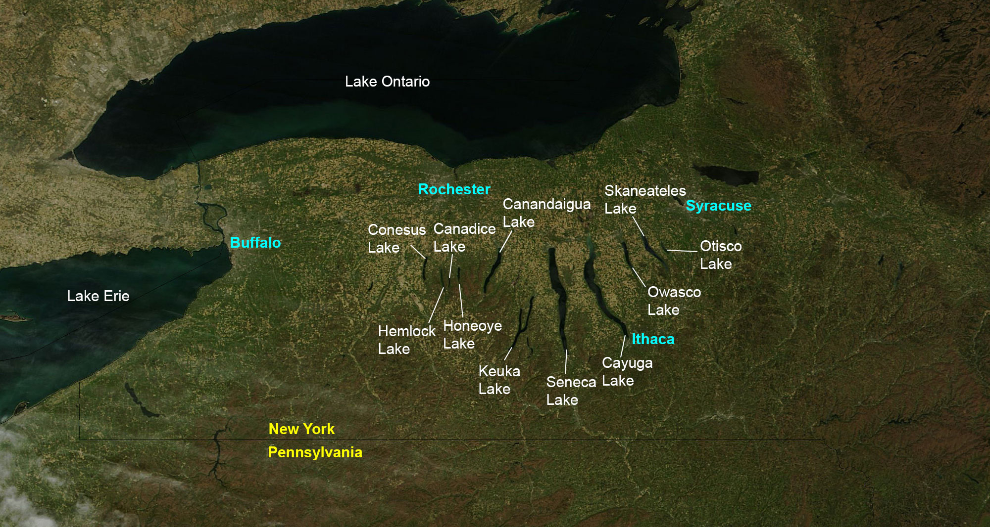
The Finger Lakes region of New York State. Image created by Jonathan R. Hendricks for PRI's Earth@Home project (CC BY-NC-SA 4.0 license). Base map from NASA Earth Observatory (public domain).
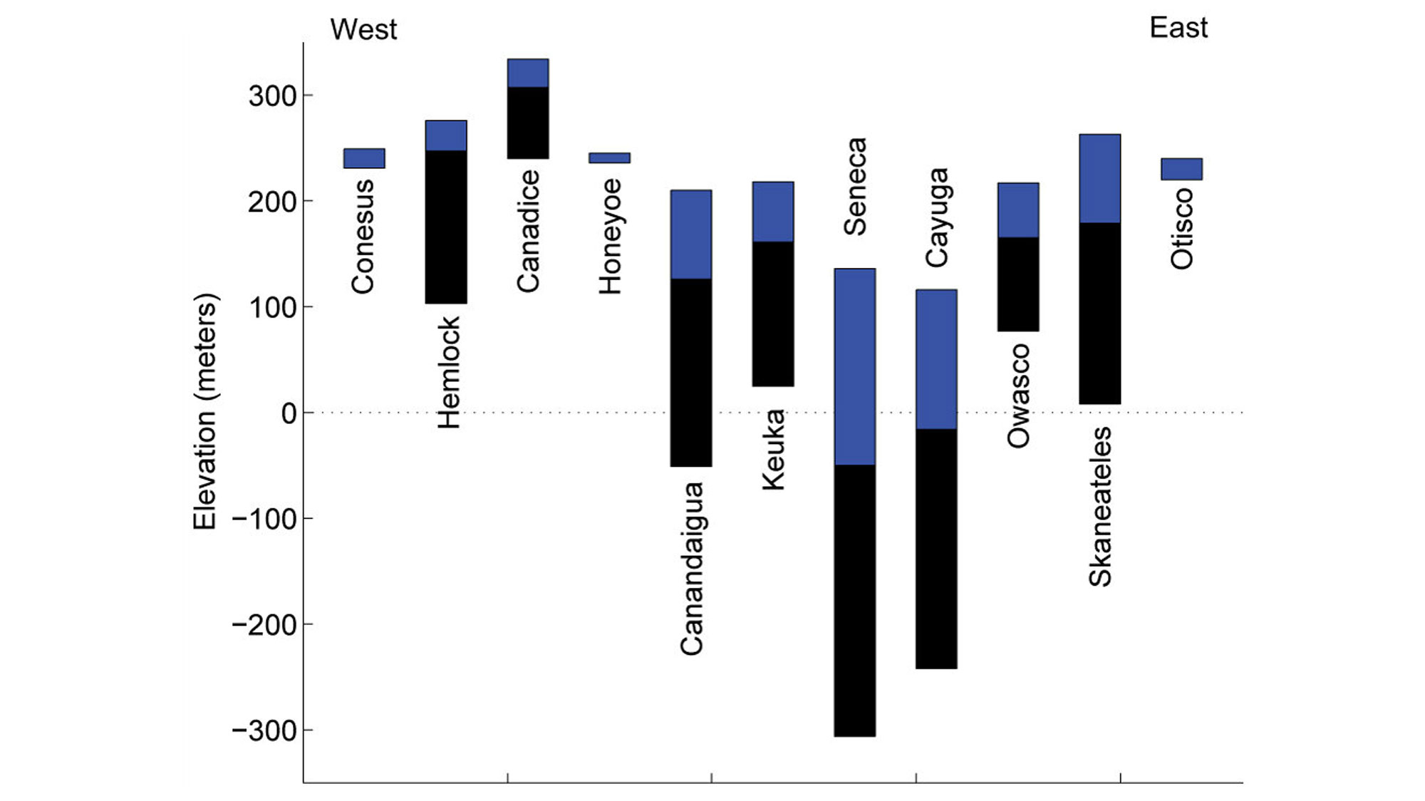
Current elevations and depths of the Finger Lakes. The blue areas represent current water depth; the black areas indicate the thickness of sediment to the maximum depth of erosion below each lake. Data are from Mullins et al. (1996). Image created by Dr. Matthew Pritchard (for educational use only) for the book Gorges History by Arthur Bloom (Fig. 5.1; published in 2018 by the Paleontological Research Institution). Copyright Paleontological Research Institution.
The Finger Lakes region is famous for its numerous gorges, which also resulted indirectly from the glaciers of the Laurentide ice sheet. After the glaciers began retreating, tributary streams began running into the Finger Lake Valleys. The erosive force of the glaciers, however, had considerably deepened these valleys. Thus, tributary streams were left hanging far above the lake surface, forming a series of waterfalls and cascades all along the Finger Lake Valleys. These stream valleys are called hanging valleys.
In a matter of only several thousand years, deep erosion by the tributary streams has moved many of the waterfalls hundreds of meters back away from the edge of the Finger Lake Valleys and created beautiful long, narrow gorges. It is possible, though not always easy, to document that some gorges were formed during one or more previous glacial advances and simply re-excavated and further eroded since the last glacial event; some gorges formed during previous glacial advances were buried by sediment (till) in the most recent glacial advance and have not been re-excavated.
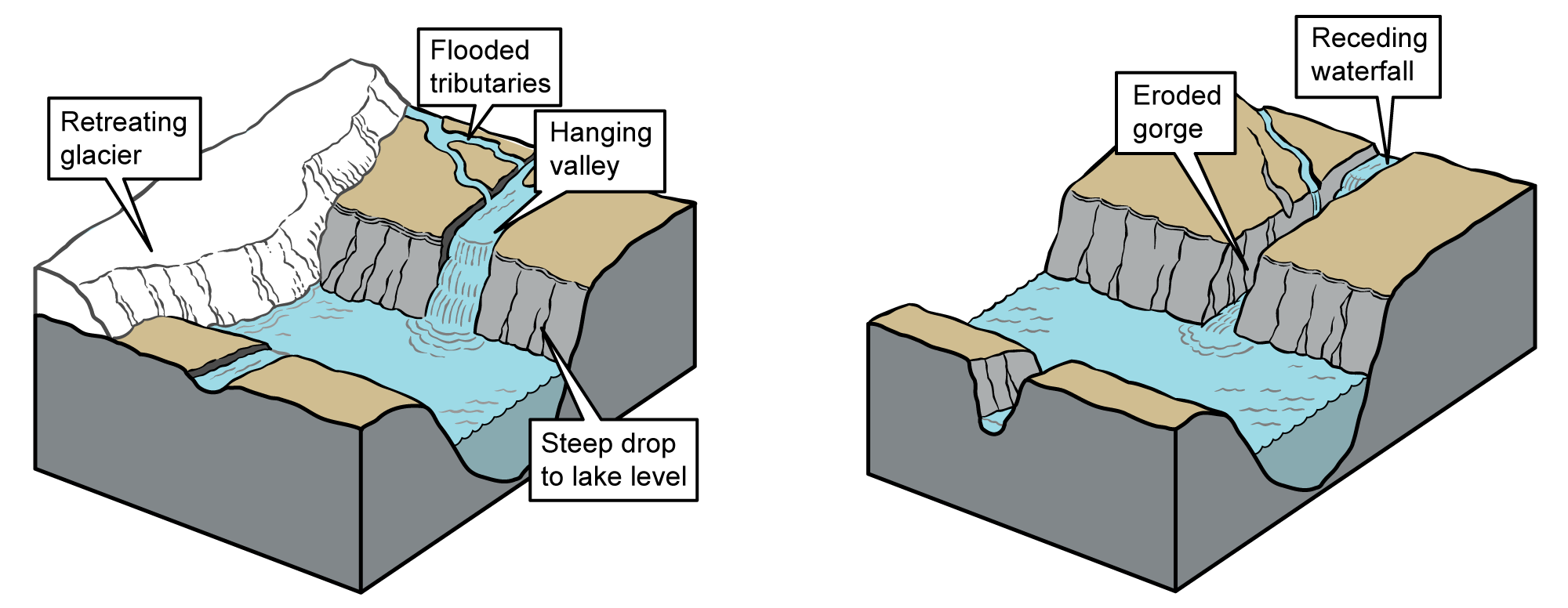
Left: Development of a hanging valley following glacial retreat. Right: Development of a post-glacial gorge as seen in the Finger Lakes region of central New York. Images modified from originals by J. Houghton first published in The Teacher-Friendly Guide to the Geology of the Northeastern U.S. by Jane Ansley (published by the Paleontological Research Institution) (CC BY-NC-SA 4.0 license).
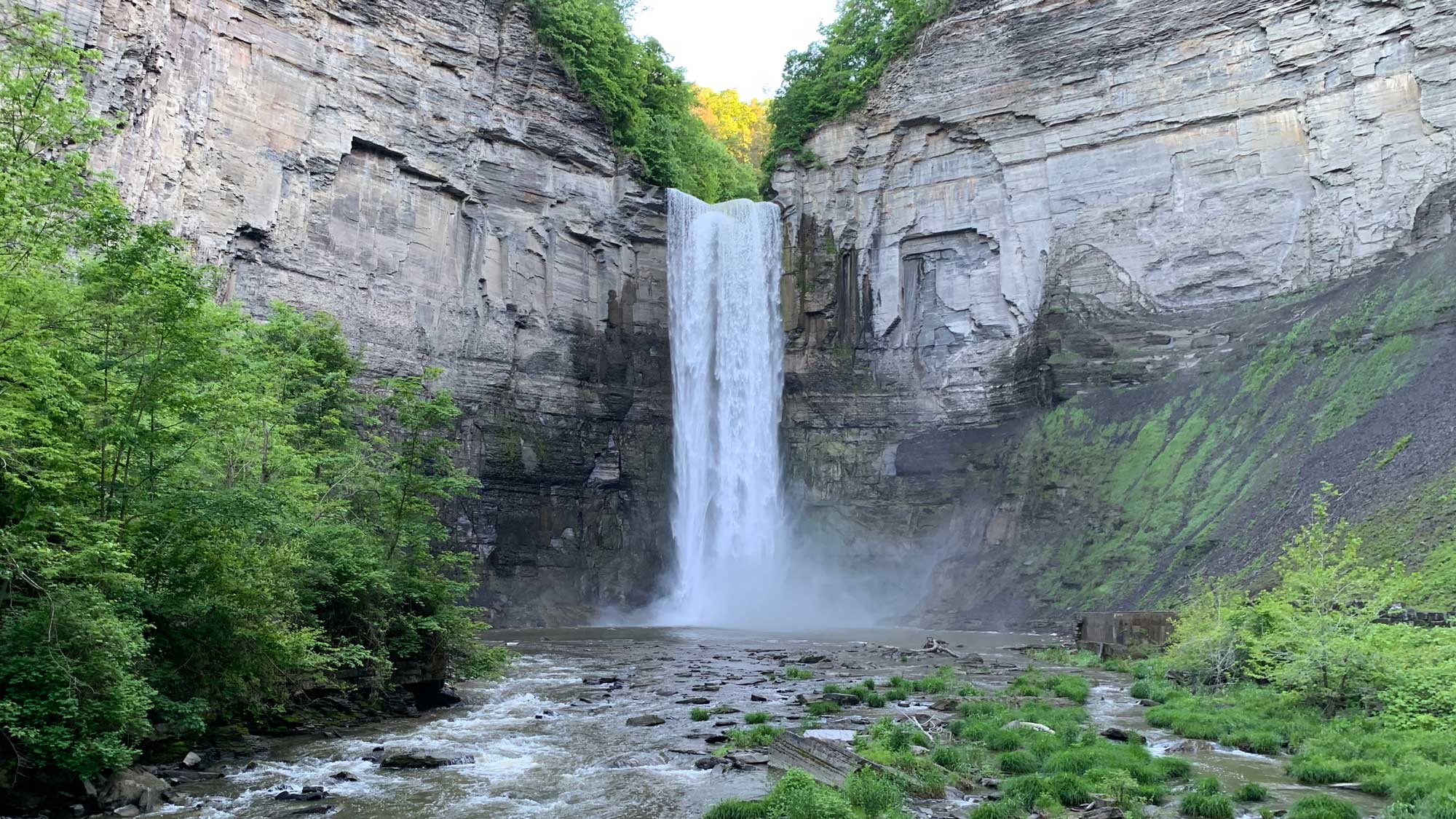
Taughhanock Falls. Photograph by Jonathan R. Hendricks for PRI's Earth@Home project (CC BY-NC-SA 4.0 license).
Champlain Sea
In the Appalachian and Piedmont region, the glaciers of the Laurentide ice sheet scoured and the meltwater flooded two major lake basins: Lake Champlain and the former glacial Lake Albany. The edge of Lake Champlain was 15 to 30 kilometers (9.3 to 18.6 miles) east of its present shoreline during most recent glacial interval. The shoreline once extended as far east as the Green Mountains, and in some areas even beyond.
The Champlain Lowlands, with their low elevation and minimal relief, show the extent of the glacial Lake Champlain. Fourteen thousand years ago, the receding ice sheet caused sea levels to rise. Because the Laurentide ice sheet was just retreating from New England, the crust was still depressed, because it had not yet had enough time to rebound. As a result, the St. Lawrence Seaway and Lake Champlain were flooded with encroaching ocean waters. Marine fossils from this time period have been found in the lakebed sediments, such as Vermont’s state fossil, the Charlotte Whale (a skeleton of a beluga whale).
Examination of the ancient shorelines left by the glacial Lake Champlain shows clear evidence for rebound of the land after the removal of the ice sheet. More than 150 meters of rebound is can be observed by looking at the once horizontal shorelines of glacial Lake Champlain.
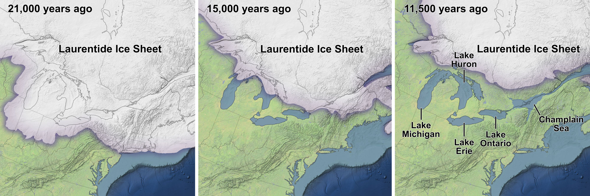
Illustration of the development of the Champlain Sea near the end of the last glacial interval. When the crust rebounded following retreat of the Laurentide Ice Sheet, the Champlain Sea retreated. Lake Champlain and the St. Lawrence River now occur where the Champlain Sea once existed. Illustrations from NASA Earth Observatory (used following NASA's image use policy).
Glacial Lake Albany
The Hudson River Valley, also deepened and broadened by the ice sheet advance, also flooded when the glaciers began to melt. Glacial Lake Albany was formed when the lowlands flooded, though the lake does not exist today. Evidence of the lake does exist, however. The glacially scoured, narrow and deep Hudson River is a fjord, similar to the fjords of the Netherlands. Ocean water extends up the river valley with the tides as far north as Poughkeepsie, New York.
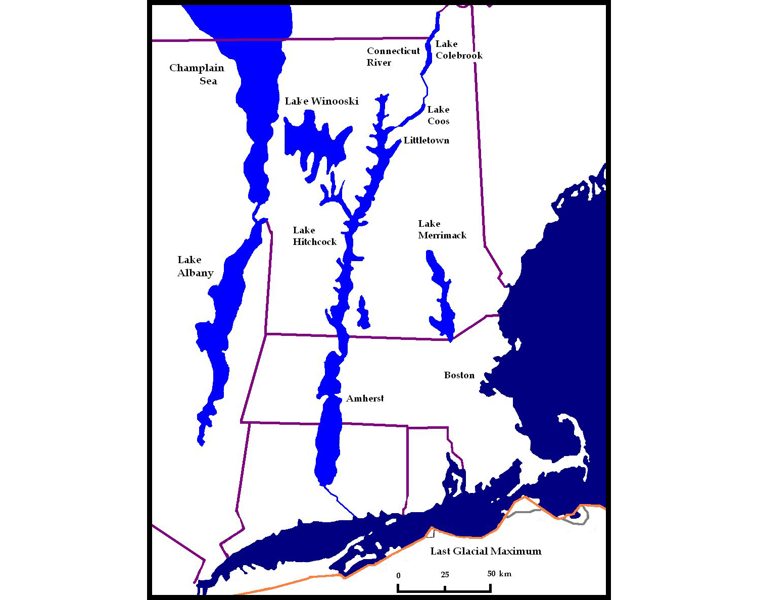
Map of the eastern New York and New England area during the last glacial maximum (southern end of ice sheet indicated by orange line) showing the southern part of the Champlain Sea and several glacial lakes. Illustration by Christ Light (Wikimedia Commons, Creative Commons Attribution-ShareAlike 4.0 International license, image modified).
Pleistocene glacial deposits
Moraines and drumlins
Central Lowland and Inland Basin regions
Moraine stretches across much of the Northeast, as far south as northern Pennsylvania and New Jersey. More than 10,000 drumlins are situated between Rochester and Syracuse in the Ontario Lowlands. The drumlins are an important clue in determining the direction of flow of the most recent advance of the ice sheet. The Ontario Lowland drumlins are all generally oriented north to south, providing solid evidence that the glaciers flowed south over the landscape.
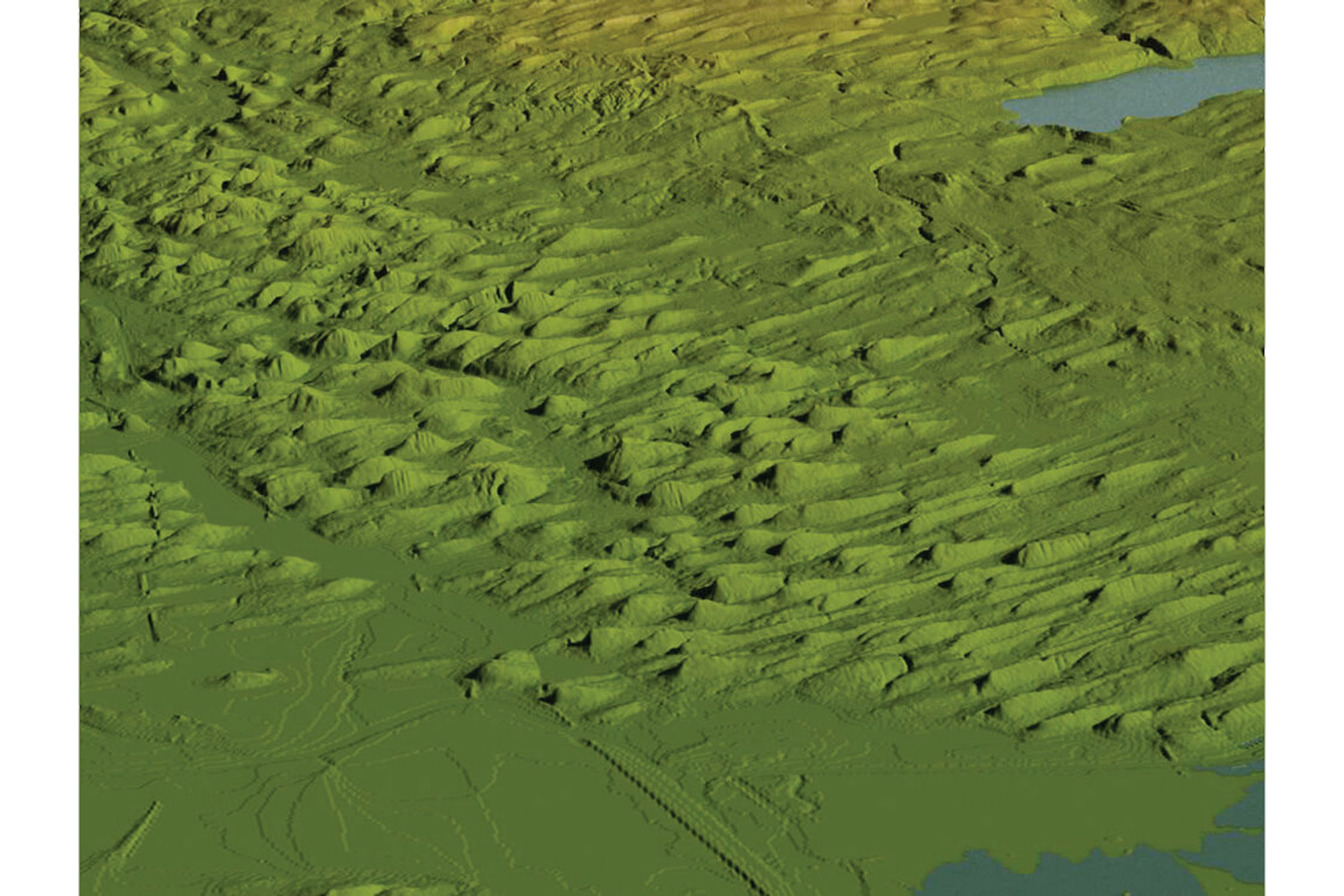
Digital elevation image of a drumlin field near Auburn, New York. Image by Rick Allmendinger (for educational use only); was published as fig. 4.9 in Gorges History: Landscapes and Geology of the Finger Lakes Region by Arthur Bloom.
Abundant drumlins and moraines occur south of the Finger Lakes in New York. The terminal moraines in the Central Lowland and Inland Basin regions include the Kent and Olean Moraines in Pennsylvania and the Valley Heads Moraine in New York. The Valley Heads Moraine is significant because it divides the St. Lawrence and Susquehanna drainage basins. Before the most recent ice age, many streams of the Inland Basin region (especially in New York and Pennsylvania) flowed south into the Susquehanna River. However, the Valley Heads Moraine blocked the flow of water to the south, damming the Finger Lakes and forcing streams to drain north into the St. Lawrence River Valley.
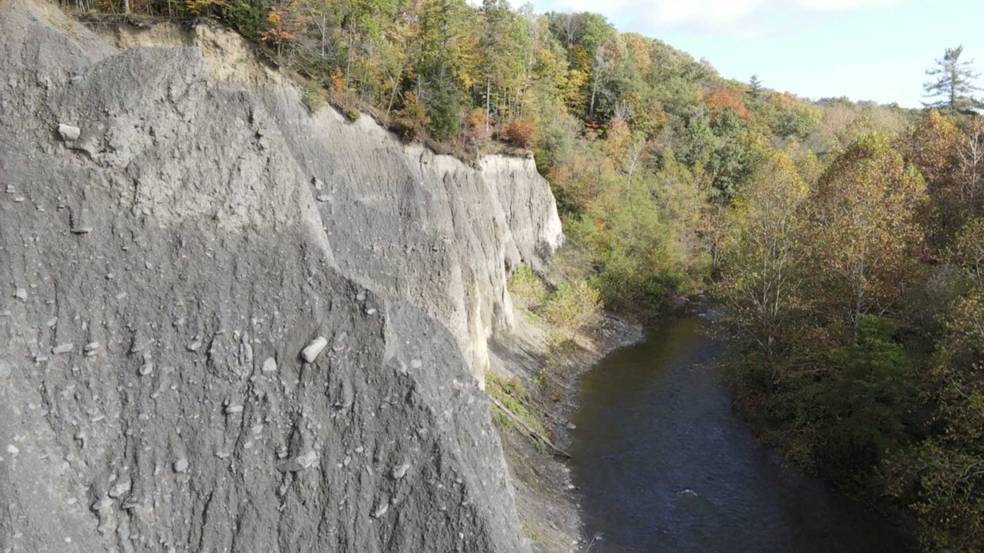
View of the modern Fall Creek stream bank that is eroded into glacial till at the Varna High Banks, near Varna, New York. Photograph by Alexandra Moore.
Extent of the Valley Heads moraine is indicated by the black line and represents maximum southern extent of the continental ice sheet during the most recent glaciation, approximately 17,000 years ago. Modified from Fig. 5.2 (created for educational use only by Rick Allmendinger) in the book Gorges History by Arthur Bloom (published in 2018 by the Paleontological Research Institution). Copyright Paleontological Research Institution.
Exotic Terrain region
On average, the moraines found in the Exotic Terrane region show approximately 30 meters (98 feet) of relief. Southeastern Maine in particular has hundreds of moraines formed where the ice sheet met the Atlantic Ocean. An enormous field of drumlins is found in southern New Hampshire and northern Massachusetts. Many of the islands in Boston Harbor include drumlins.
The Connecticut Valley became a lake when an end moraine dammed the valley and blocked drainage. When the moraine-dam was broken, the 257-kilometer (160-mile) long lake drained away. The lake bottom sediments dried up and blew around, forming thick dune deposits of blown sand. Eventually these wind-blown deposits became vegetated to form the floor of the valley.
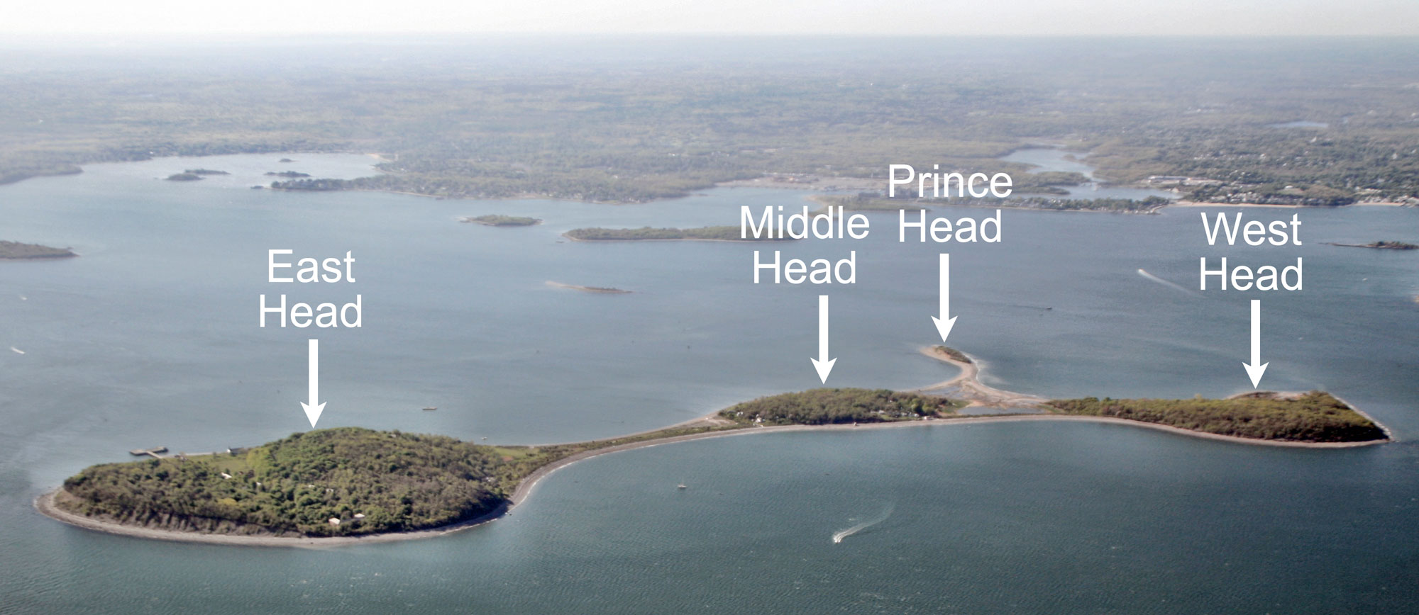
Peddocks Island in Boston Harbor is made up of headlands ("heads") connected by thin tombolos (strips of land). East Head is made up of two drumlins, while the other heads are each made up of one drumlin. Photo by Doc Searles (flickr, Creative Commons Attribution-ShareAlike 2.0 Generic license, image cropped, resized, and labeled).
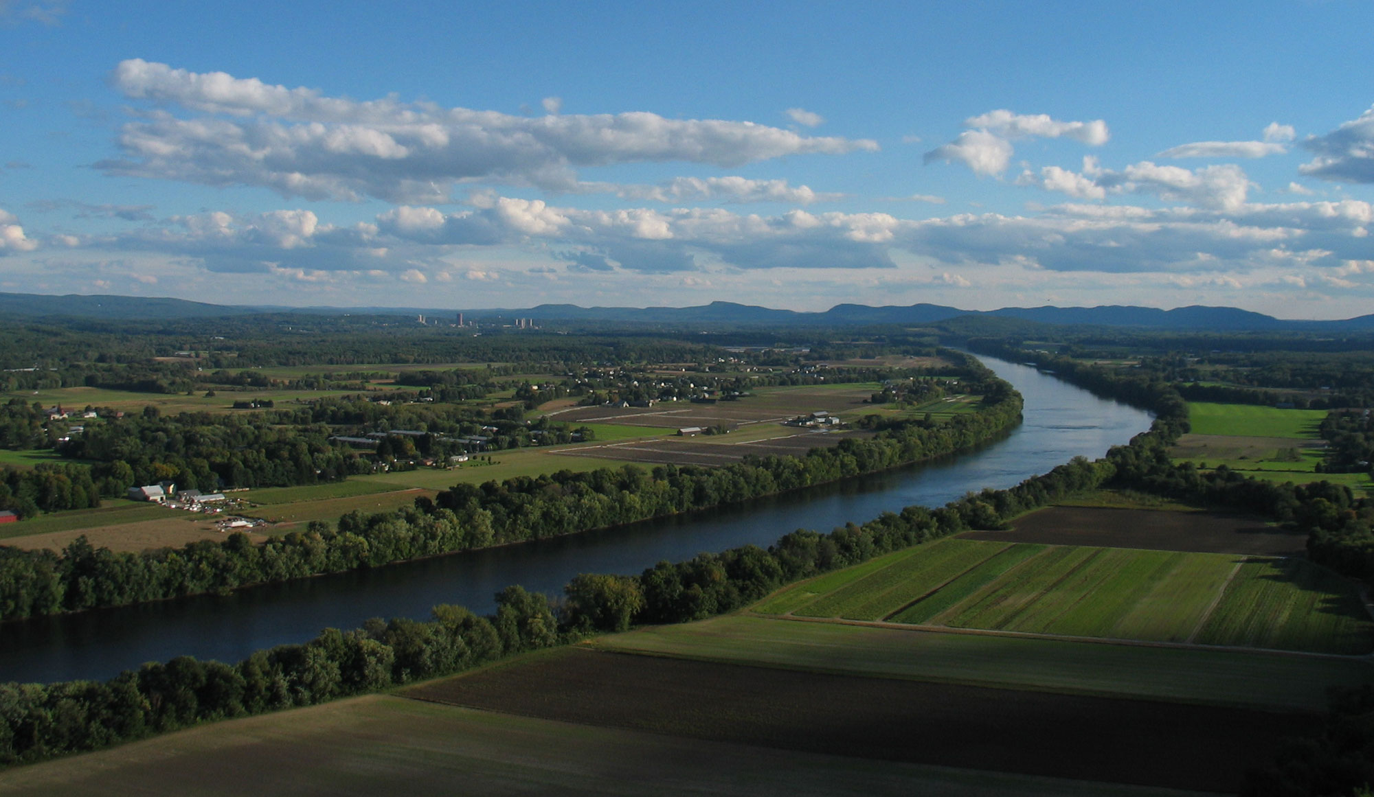
The Connecticut River Valley in Massachusetts. The mountains on the horizon are the Holyoke Mountains. Photo by BenFrantzDale (Wikimedia Commons, Creative Commons Attribution-ShareAlike 3.0 Unported license, image cropped and resized).
Cape Cod and off-shore islands
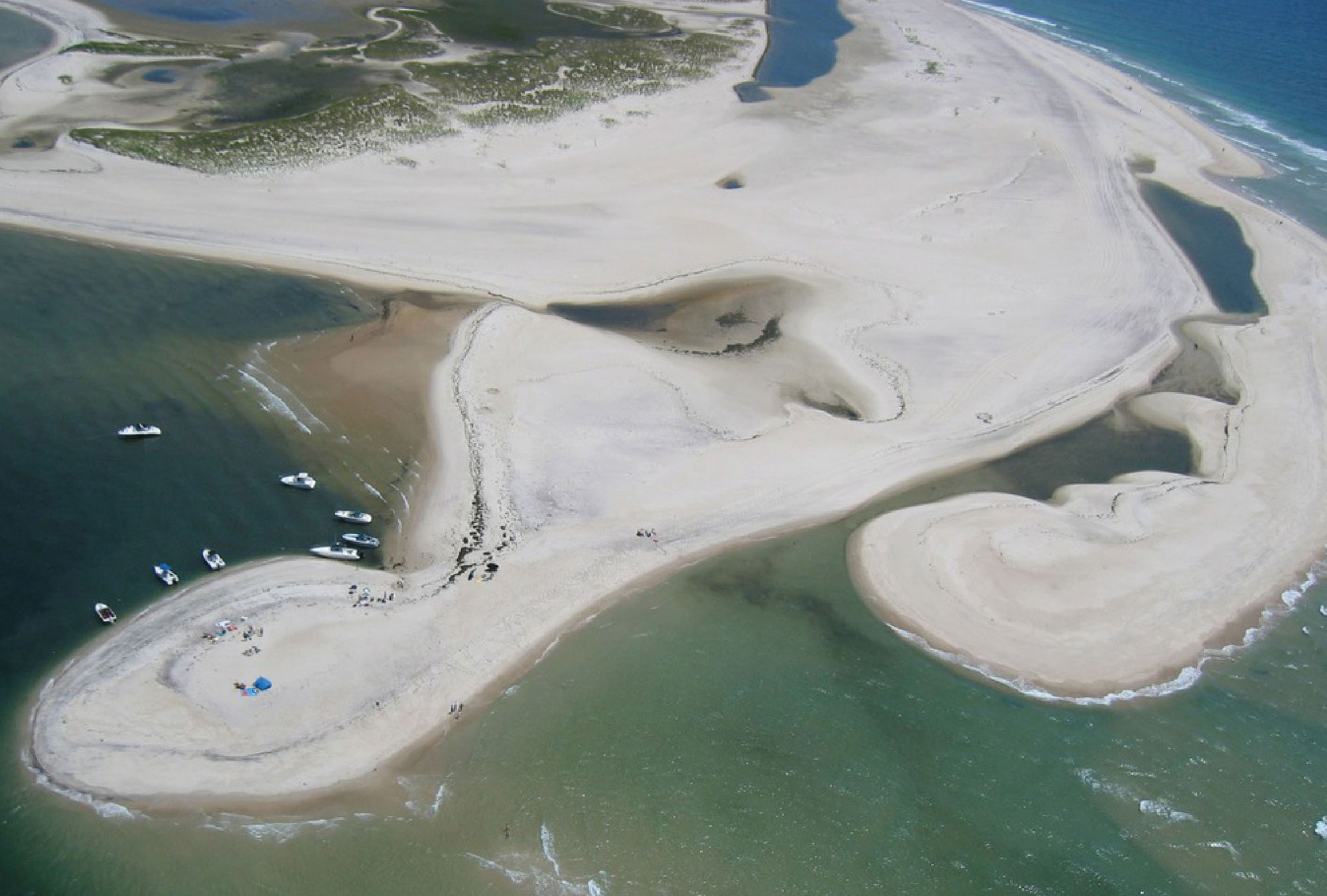
Long Island, Cape Cod, Martha’s Vineyard, Block Island, and other islands off the New England and New York coast are end moraines deposited during the most recent ice age that mark the maximum extent of the ice sheet 20,000 years ago. When the ice sheet paused in its advance over the Northeast, the melting ice deposited massive quantities of sand and gravel at its terminus.
The Ronkonkoma Moraine runs the length of Long Island and forms many of the smaller islands off the coast. The Harbor Hill Moraine stretches across northern Long Island and upwards to form the coast of Rhode Island and Cape Cod. There are no skyscrapers on Long Island because of the loose, unconsolidated glacial till that makes up the island. Till is not stable enough for very tall buildings. Not far away, however, tower the skyscrapers of Manhattan, such as the Empire State Building, built on the very resistant, metamorphosed Precambrian and Cambrian rocks of the Manhattan Prong.
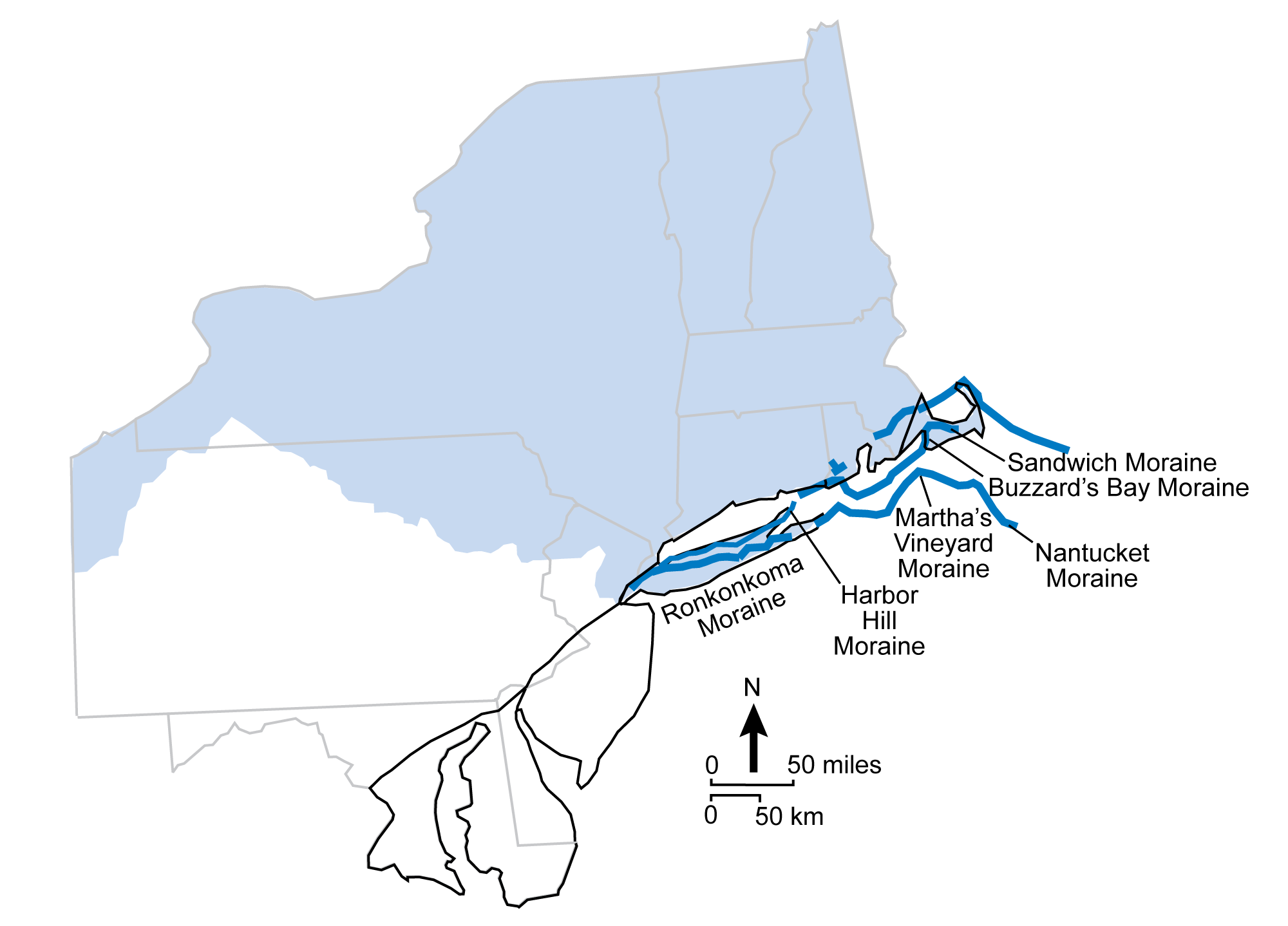
Terminal moraines of the Coastal Plain. The black line represents the boundary of the Coastal Plain region. The light blue shading represents the maximum extent of the most recent continental ice sheet. The dark blue lines are terminal moraines. Modified from figure 3.16 in The Teacher-Friendly Guide to the Geology of the Northeastern U.S. by J. E. Ansley (published in 2000 by the Paleontological Research Institution, reprinted in 2016).
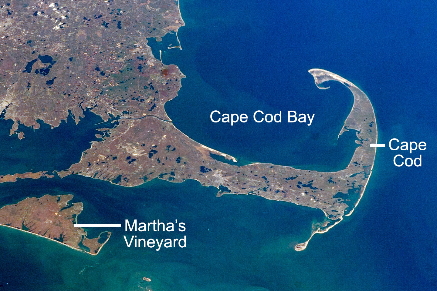
Satellite photo of Cape Cod, Massachusetts, and part fo Martha's Vineyard, November 7, 2007. These landforms are made up of moraines. Kettle lakes (discussed below) can be seen on Cape Cod and in mainland Massachusetts. Source: Astronaut photograph ISS016-E-10312, modified by NASA Earth Observatory (image used following NASA's image use policy).
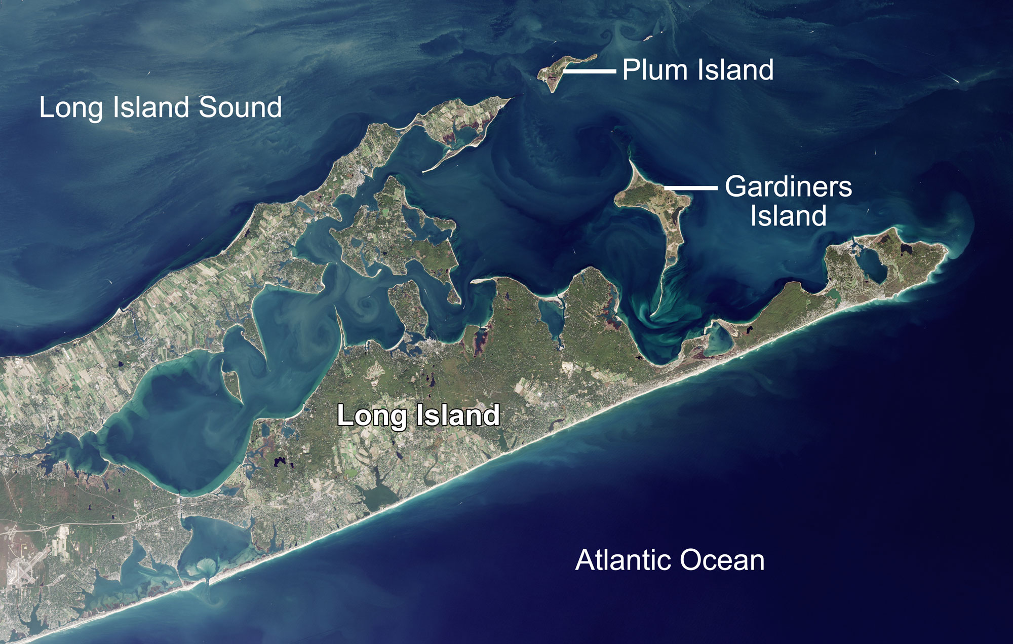
Satellite photo of the eastern tip of Long Island, New York, October 17, 2016. Long Island is largely made up the the Ronkonkoma and Harbor Hills moraines. Source: NASA Earth Observatory image by Jesse Allen (image used following NASA's image use policy).
Original caption: "Fire Island National Seashore, New York. Fire Island has deposits from the continental ice sheet (terminal moraines) that were reworked by wave action." Fire Island is located to the south of Long Island. Source: NPS photo (public domain).
Kettle lakes
Kettle lakes or the lakebed deposits of kettle lakes are common throughout the Northeast. Thoreau’s Walden Pond in Concord, Massachusetts, is actually a kettle pond, formed when a buried block of glacial ice melted and overlying sediments collapsed to form a depression that filled with lake water.
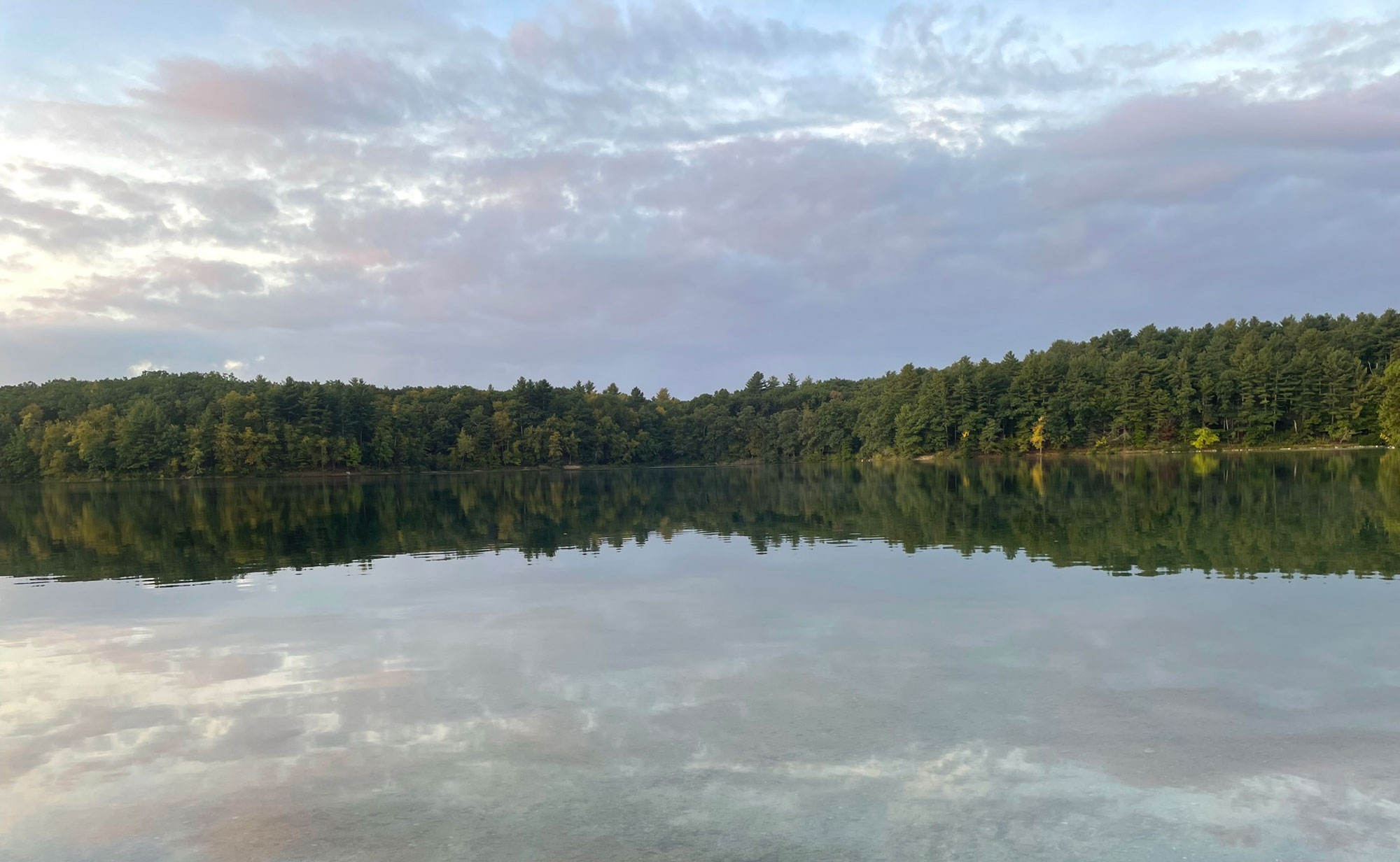
Walden Pond, Concord, Massachusetts. Photo by Radha Raman Gargeya (Wikimedia Commons, Creative Commons Attribution-Share Alike 4.0 International license, image cropped and resized).
Eskers
Eskers are common in the Exotic Terrane region, particularly in Maine. These features were deposited by streams of meltwater flowing under the glacier. Well-sorted sand and gravel were left behind as sinuous ridges, or eskers, when the ice sheet receded. The abundance of sand and gravel that forms eskers has made them an easy target for mining. Many eskers no longer exist because the sand and gravel has been removed and sold. As it turns out, Maine has the longest eskers in the world.
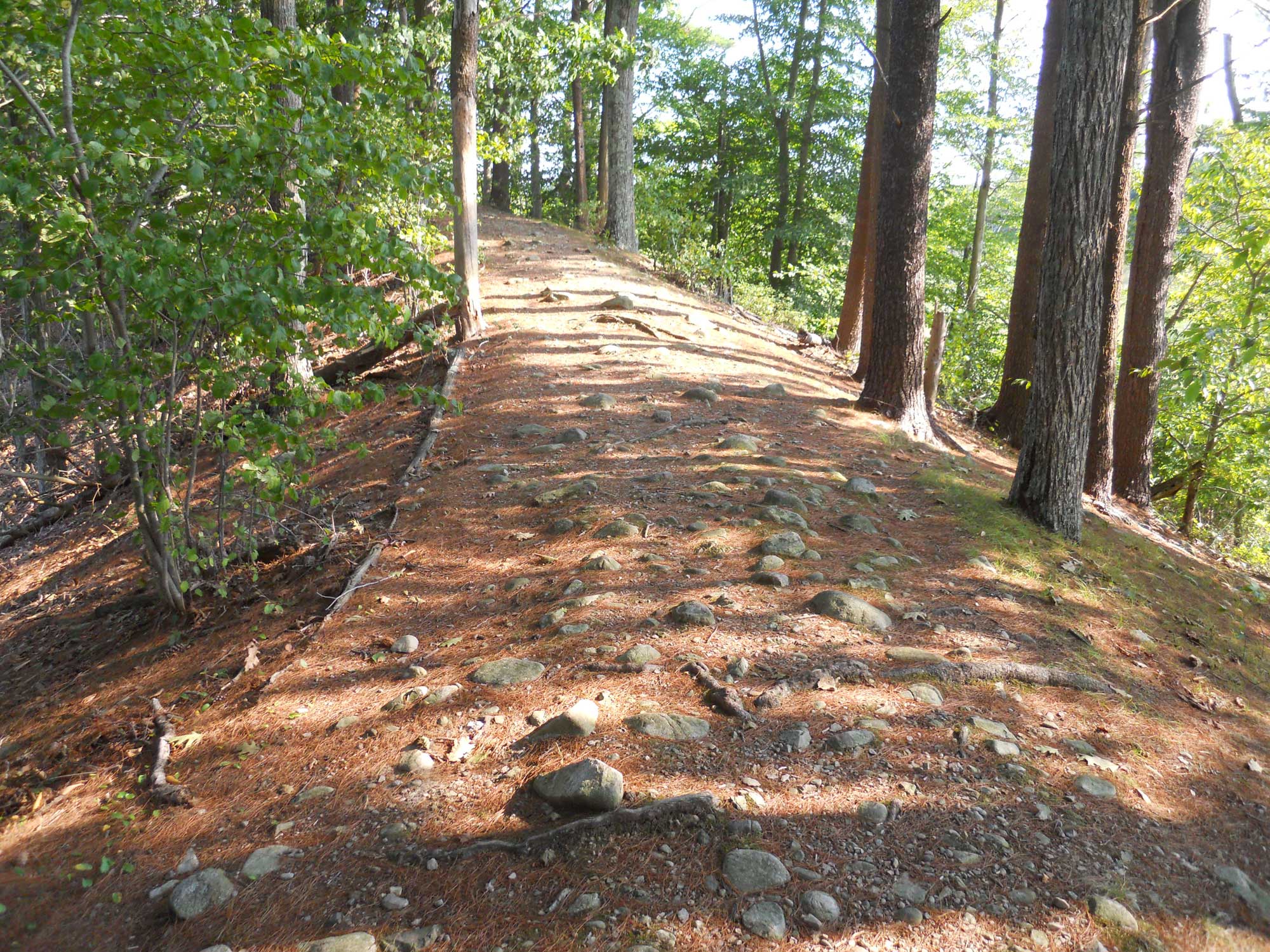
A trail along the top of an esker, Averill's Island, Massachusetts. Photo by Botteville (Wikimedia Commons, Creative Commons Attribution-Share Alike 3.0 Unported license, image resized).
Periglacial deposits
During the Pleistocene, most of New Jersey and Pennsylvania and all of Maryland were left ice-free. Much of this region not covered by the ice sheet was periglacial, showing characteristic features of permafrost. Evidence of Pleistocene permafrost, including solifluction (permafrost-area mudslides), patterned ground, and boulder fields, occurs throughout much of Pennsylvania and in western Maryland and central New Jersey.
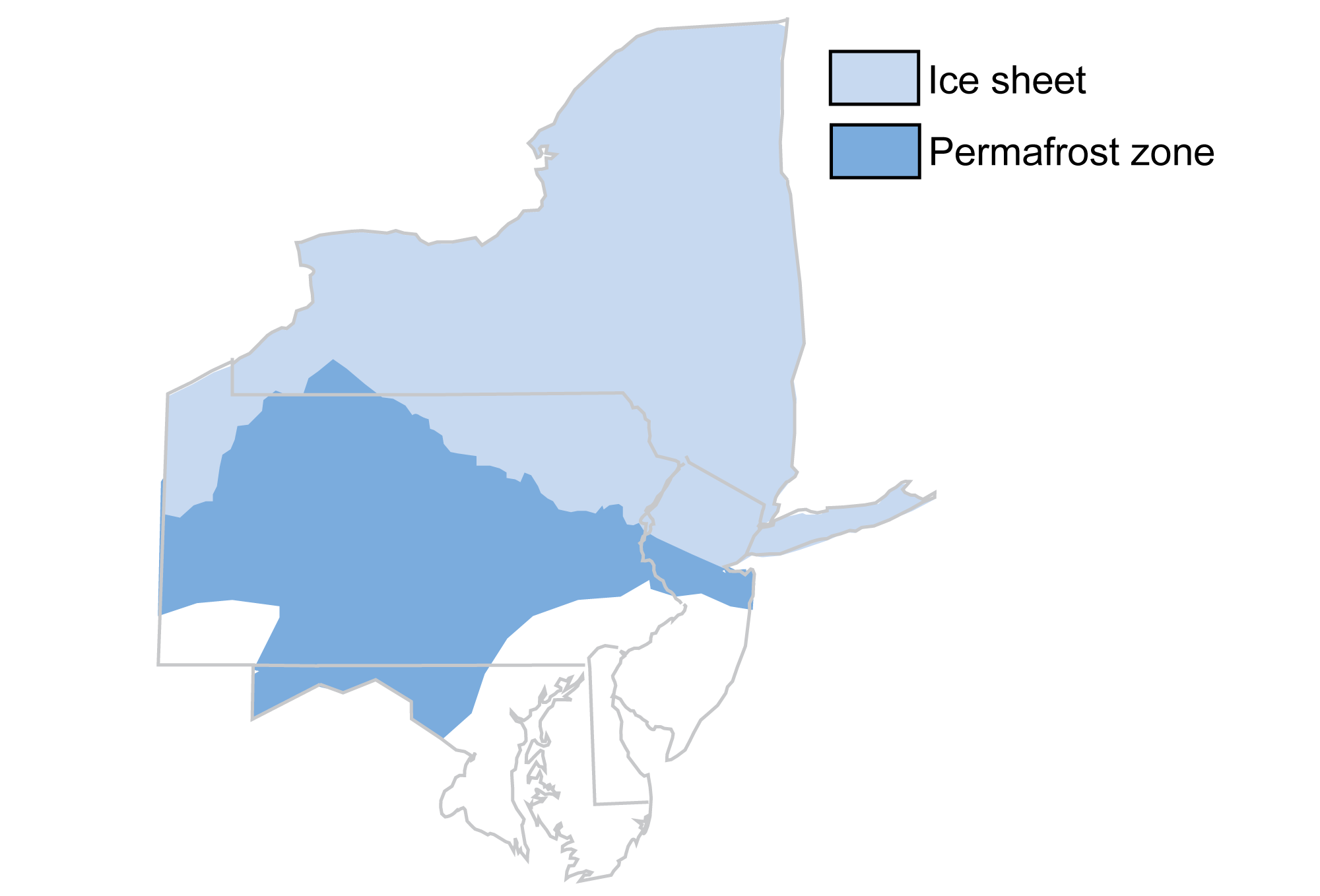
Map of a portion of the northeastern United States, showing glaciated (ice sheet) and periglacial (permafrost zone) regions. Maine, which is not depicted, was glaciated. Modified from figure 3.15 in The Teacher-Friendly Guide to the Geology of the Northeastern U.S. by J. E. Ansley (published in 2000 by the Paleontological Research Institution, reprinted in 2016).
The steep, mountainous topography in parts of the Northeast aided in speeding up physical weathering of the rocks in the periglacial region. Boulder fields, some deeper than 3 meters, formed when blocks of rock from nearby ridges were loosened by freezing and thawing water in fractures and cracks. The boulders tumbled downslope, creating fields of rocks. The majority of boulder fields occur in the formerly periglacial region of eastern Pennsylvania and western Maryland. Some of the best examples of boulder fields in Pennsylvania include Hickory Run in Carbon County, Blue Rocks in Berks County, Ringing Rocks in Bucks County, and Devils Race Course in Dauphin County.
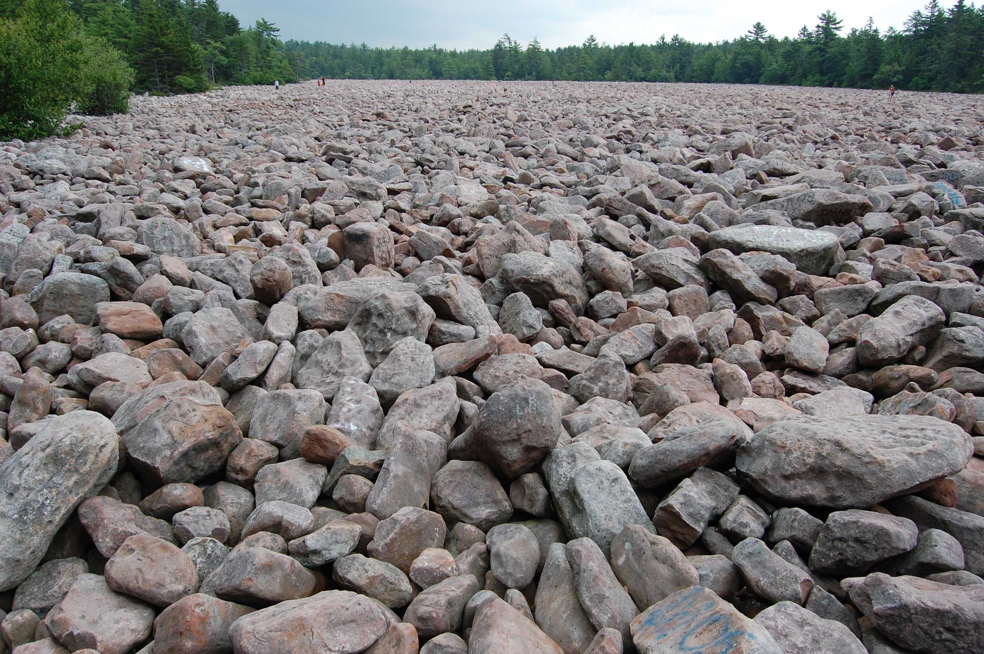
Boulder field at Hickory Run State Park, Carbon County, Pennsylvania. Photo by Mtruch (Wikimedia Commons, Creative Commons Attribution-ShareAlike 3.0 Unported license, image resized).
Other periglacial features found in the Pleistocene periglacial Northeast are less obvious, including evidence of patterned ground and solifluction. In regions where permafrost occurs, ice wedges form patterned ground, or ground with polygonal patterns. When the ice wedges melt, the wedges can fill with sediment. In parts of New Jersey and Pennsylvania, ice wedge casts created polygonal patterns in the ground. The polygons range from 3 to 30 meters (about 10 to 98 feet) in diameter. Solifluction occurs when sediments become increasingly heavy with water from thawing in the periglacial environment, finally causing them to flow rapidly downslope.
Pingo scars also occur in Pleistocene periglacial regions of the Northeast. A pingo is a mound made up of ice covered by a thin layer of soil. Pingos form when water collects above permafrost and freezes. When the ice in a pingo melts, the mound deflates, forming a depression, or pingo scar.
A pingo scar, Halfway Run Natural Area, Bald Eagle State Forest, Pennsylvania. Photo by Nicholas_T (flickr, Creative Commons Attribution 2.0 Generic license, image resized).
Resources
Resources from the Paleontological Research Institution
Books
Bloom, A. L. 2018. Gorges history: landscapes and geology of the Finger Lakes region. Paleontological Research Institution, Ithaca, New York, 214 pp.
Websites
Earth@Home: Earth Science of the Northeastern United States: Ithaca is Gorges: The glacial landscape of the Cayuga Lake Basin and Fall Creek: https://earthathome.org/hoe/ne/cayuga-trail-fall-creek/
Earth@Home: Here on Earth: Introduction to Glaciers: https://earthathome.org/hoe/glaciers/