

Page Snapshot: Introduction to Earth hazards in the Northwest Central United States, including Idaho, Montana, Wyoming, North Dakota, South Dakota, and Nebraska.
Contents
Topics covered on this page: Earthquakes; Volcanism; Landslides; Karst and sinkholes; Radon; Floods; Weather hazards; Climate change; Resources.
Credits: Most of the text on this page comes from "Earth Hazards of the Northwest Central US" by Libby Prueher and Andrielle N. Swaby, chapter 10 in The Teacher-Friendly Guide to the Earth Science of the Southwestern US, edited by Make D. Lucas, Robert M. Ross, and Andrielle N. Swaby (published in 2015 by the Paleontological Research Institution). The book was adapted for the web by Elizabeth J. Hermsen and Jonathan R. Hendricks in 2021–2022. Changes include formatting and revisions to the text and images. Credits for individual images are given in figure captions.
Updates: Page last updated October 28, 2022.
Image above: Damage to the north entrance of Yellowstone National Park during flooding in June 2022. Photograph by Yellowstone National Park (Wikimedia Commons; public domain).
Introduction
Natural hazards or earth hazards are events or processes that have significant impacts on human beings and the environment. Extreme weather conditions or geologic activity can cause substantial short-term or long-term changes to our environment. These changes can influence many aspects of the world around us, including crops, homes, infrastructure, and the atmosphere. The 4.6-billion-year-old Earth has experienced many naturally generated hazards, while other events are byproducts of human activities, created during mineral and energy extraction or in construction practices that modify the landscape.
The Northwest Central is subject to a variety of earth hazards. Weather hazards such as tornados, thunderstorms, and winter storms are particularly common in the Central Lowland and Great Plains, thanks to the unobstructed movement of air masses over areas of low topographic relief. The Rocky Mountains are susceptible to extreme winter weather such as heavy snow, blizzards, and high winds. Flooding can occur in areas of low elevation, including low-lying glacially sculpted terrain. Geological hazards, including avalanches, earthquakes, landslides, and rockfalls, are also common throughout the Northwest Central, especially in areas with rugged, mountainous terrain. The Columbia Plateau is susceptible to volcanic material produced by the Cascade Volcanoes to the west, and igneous activity associated with the Yellowstone hot spot has made its mark upon the surrounding land.
Earthquakes
The largest recorded earthquake in the Northwest Central occurred in 1959 at Hebgen Lake, Montana (M7.3), near Yellowstone National Park. Other notable earthquakes are listed in the table below.
| Date | Location | Mw |
|---|---|---|
| August 18, 1959 | Hebgen Lake, Montana | 7.3 |
| October 28, 1983 | Borah Peak, Idaho | 6.9 |
| June 28, 1925 | Clarkston Valley, Montana | 6.6 |
| October 19, 1935 | Helena, Montana | 6.3 |
| November 23, 1947 | Madison County, Montana | 6.3 |
| March 28, 1975 | Malad City, Idaho | 6.2 |
| July 12, 1944 | Sheep Mountain, Idaho | 6.1 |
| June 30, 1975 | Yellowstone National Park, Wyoming | 6.1 |
| May 16, 1909 | Dickinson, North Dakota | 5.5 |
| March 28, 1964 | Merriman, Nebraska | 5.1 |
The figure below shows the intensities felt in surrounding areas after the 1983 Earthquake at Borah Peak, Idaho, which is the largest earthquake known to have occurred in the state.
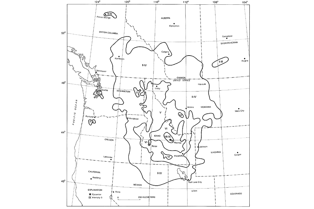
Intensity map of the 1983 Borah Peak earthquake. Image by USGS (public domain).
The Rocky Mountain and Columbia Plateau regions of the Northwest Central, including western Montana, northwestern Wyoming, and most of Idaho, compose one of the most seismically active areas in the United States, with as many as 3000 earthquakes occurring each year (although most are too small to feel).
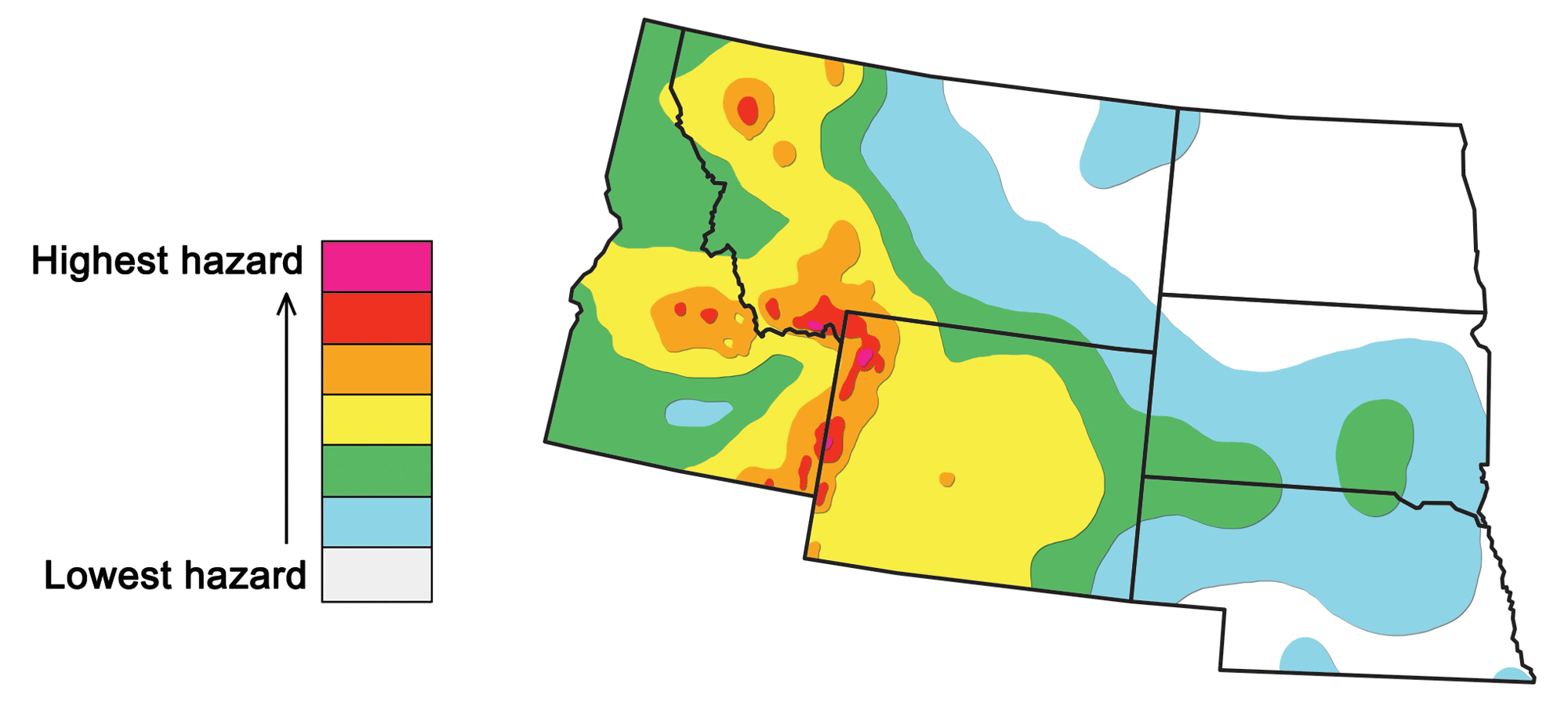
Seismic hazard map of the Northwest Central US, based on data in 2014. Adapted from image by USGS (public domain).
Most of these earthquakes are caused by a combination of two phenomena: the magmatic activity of the Yellowstone hot spot, and the (possibly related) tectonic activity of the Basin and Range region. The resulting crustal movements cause most earthquakes to be localized in particular areas, either around the Yellowstone area or along linear seismic belts or zones.
The Intermountain Seismic Belt is a major zone of earthquake activity that extends from the Flathead Lake region in the northwest corner of Montana, southward through Yellowstone Park, along the Idaho-Wyoming border, through Utah, and into southern Nevada.
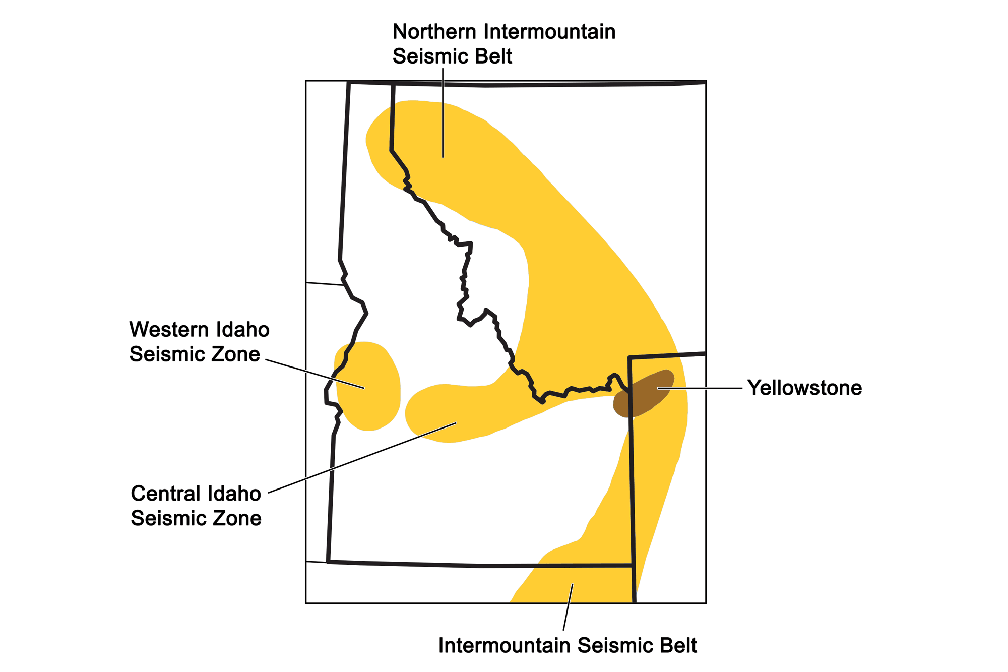
Major seismic belts and zones of the Northwest Central United States. Map by Wade Greenberg-Brand, adapted from image by Idaho Bureau of Homeland Security; modified for Earth@Home project.
A branch of the Intermountain Seismic Belt, called the Centennial Tectonic Belt or Central Idaho Seismic Zone, extends west from the northwest corner of Yellowstone National Park through southwestern Montana and into central Idaho.

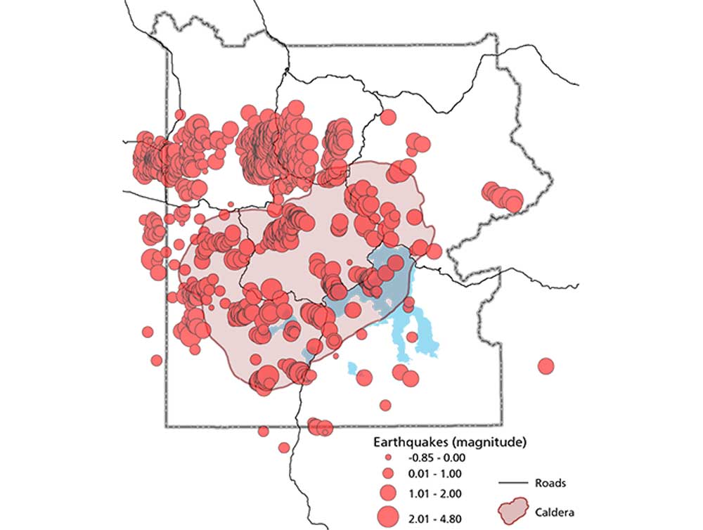
Earthquake occurrences (M2.5+) in the Central Idaho Seismic Zone and Western Idaho Seismic Zone between 2000 and 2020. Earthquake epicenters are shown as gray circles. The locations of Borah Peak and Hebgen Lake are marked by red dots. Map by Jonathan R. Hendricks for the Earth@Home project; earthquake data and map from the USGS Earthquake Catalog (public domain).
This zone includes at least eight major active faults, and was the site of the two most severe earthquakes in the Rocky Mountains: the Hebgen Lake and Borah Peak earthquakes. The M7.3 Hebgen Lake earthquake, which occurred near the Montana-Wyoming Border in 1959, caused a major landslide that resulted in 28 fatalities as well as damming a river and destroying roads and buildings.
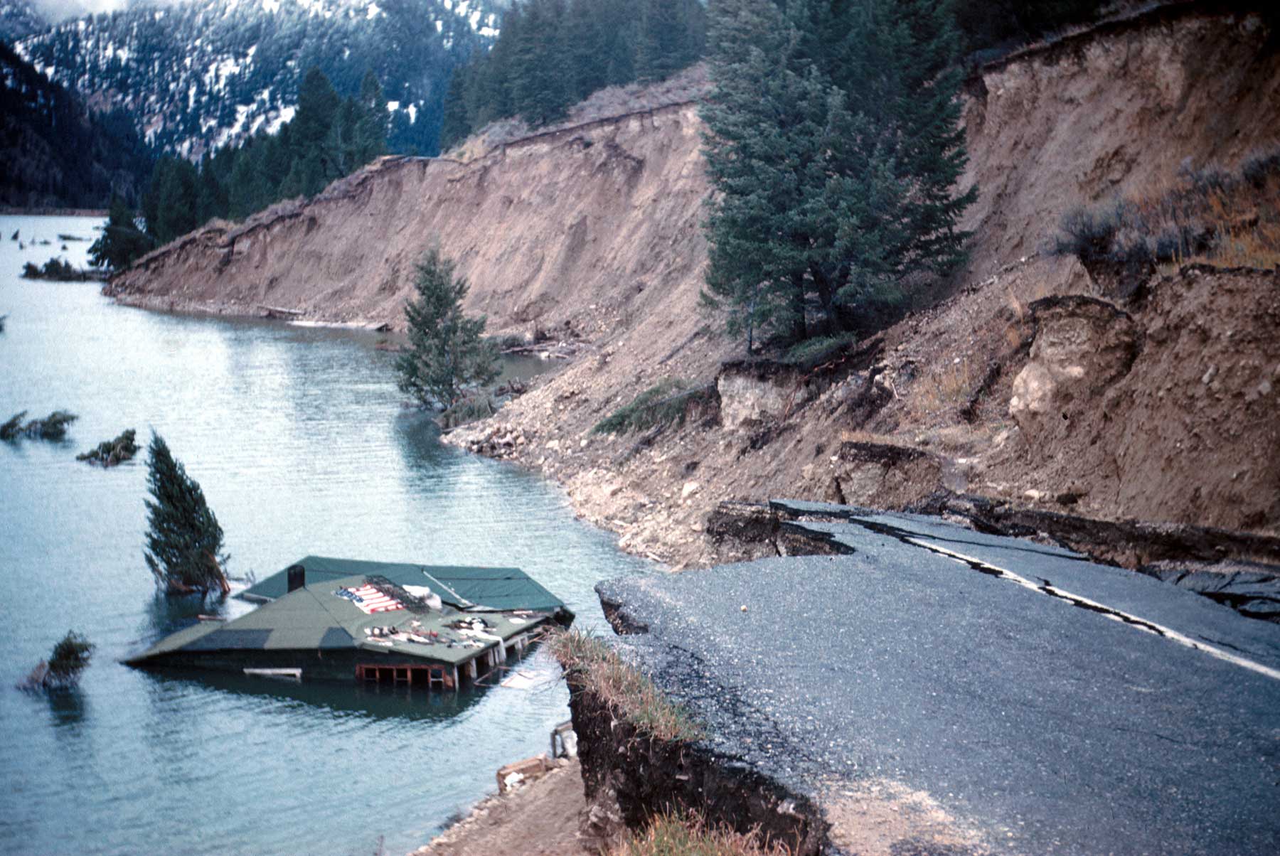
Earthquake damage to State Highway 287 and the Hilgard Lodge near Hebgen Lake, Montana. Photograph by USGS (public domain).
The M6.9 Borah Peak earthquake occurred in Idaho in 1983, and caused extreme surface faulting as well as $12.5 million worth of damage to infrastructure in the surrounding Challis-Mackay area. A 34-kilometer-long (21-mile-long) fault scarp formed along the slopes of the Lost River Range; in other areas, the ground was shattered into huge blocks up to 100 meters (330 feet) in width.
A geologically distinct region called the Western Idaho Seismic Zone lies between McCall and Boise. It is characterized by prominent north-south-trending basins and ranges that contrast strikingly with the surrounding area. A complex suture zone between accreted terranes and the ancient North American tectonic plate underlies the region and may influence the north-south orientation of the Zone’s faults. Major active faults in the Western Idaho Seismic Zone include the Squaw Creek fault and the Long Valley fault zone, which is notable for earthquake swarms. During a swarm, thousands of small shallow earthquakes occur over several weeks to months within a relatively small region.
The Lewis and Clark Zone is a megashear in the Earth’s crust, up to 48 kilometers (30 miles) wide, which runs some 386 kilometers (240 miles) through north Idaho and northwestern Montana. Geologic studies have shown that the North American plate has been sheared along this zone repeatedly over the past billion years, meaning that the rocks have been continuously fractured due to compressive stress. The most obvious manifestation of the zone is a set of parallel valleys that follow brittle fault zones across the grain of the northern Rocky Mountains from Helena and Missoula, Montana to Coeur d’Alene, Idaho. These valleys provided a natural transportation corridor through the mountains used in part by Lewis and Clark in 1806 and the Mullan Trail of the 1850s, and today by Interstate 90. Along the Lewis and Clark Zone in Idaho, many mining-related seismic events, called rockbursts, have occurred. Rockbursts are spontaneous, violent fractures of rock in deep mines. The sizable magnitudes of these events, their alignment with the direction of horizontal strain, and their location within the Lewis and Clark Zone suggest that tectonic stress release may be involved in causing them.
Earthquakes have many different effects on the rocks in which they occur, including breaking and movement along faults, uplift, and displacement. Earthquakes around Yellowstone National Park have altered the area’s extensive hydrothermal systems and may help to keep open the fractures and conduits that supply hot water to the surface. For example, both the 1959 Hebgen Lake and 1983 Borah Peak earthquakes caused measurable changes in the output of Old Faithful geyser and other hydrothermal features. Yellowstone is one of the most active seismic zones in the United States, and commonly experiences earthquake swarms.
Earthquakes in Yellowstone National Park, 2014. Approximately 2000 earthquakes occurred during the course of the year. Image by the National Park Service (public domain).
The largest swarm occurred in 1985, with more than 3000 earthquakes recorded on the northwest side of the park during a three-month period. Scientists believe these swarms are caused by shifting and changing pressures in the crust due to the migration of hydrothermal fluids, a common occurrence around volcanoes.
Volcanism
While there are no active volcanoes in the Northwest Central US today, past volcanism has left its mark on the area. Igneous activity continues today in and around Yellowstone National Park in northwestern Wyoming, which overlies a hot spot in the Earth’s mantle. During the Cenozoic, as the North American plate traveled over this mantle plume, the crust melted and produced a trail of volcanic rock that crosses southern Idaho, forming the Snake River Plain and ending at Yellowstone National Park. The trail of volcanic eruptions from the hot spot works its way east along this path. For example, the rocks at Craters of the Moon National Monument in southeastern Idaho formed during eight major eruptive periods between 15,000 and 2000 years ago. During this time, lava associated with the Yellowstone hot spot erupted from the Great Rift, a series of deep cracks that start near Craters of the Moon’s visitor center and stretch 84 kilometers (52 miles) to the southeast. Over the course of eruption, the lava field grew to cover 1600 square kilometers (618 square miles).
The recent geological history of volcanism at Yellowstone has led the area to be classified as a supervolcano—a volcano capable of producing more than 1000 cubic kilometers (240 cubic miles) of ejecta. Supervolcanoes can occur when magma rises under the crust from a hot spot, but is unable to break through. Eventually, the crust ruptures when it can no longer contain the built-up pressure. Although the Yellowstone area contains no active volcanoes today, the Yellowstone hot spot was the source of several prehistoric supereruptions: the Huckleberry Ridge, 2.1 million years ago, which produced 2450 cubic kilometers (588 cubic miles) of ejecta; the Mesa Falls flow, 1.3 million years ago, which produced 280 cubic kilometers (67 cubic miles) of ejecta; and the Lava Creek flow, 630,000 years ago, which produced 1000 cubic kilometers (240 cubic miles) of ejected material.
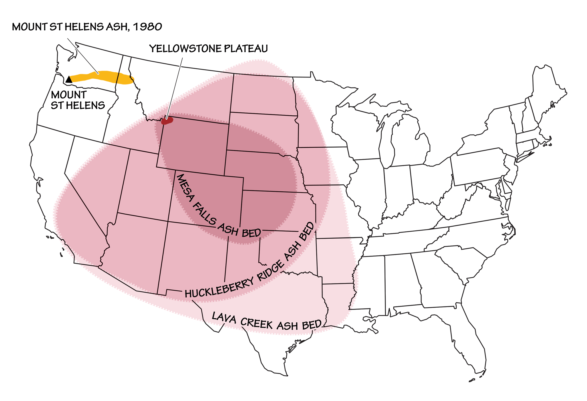
The extent of the three most recent ashfalls from Yellowstone supervolcano eruptions, as compared to the eruption of Mount St. Helens in 1980. Image by Wade Greenberg-Brand, adapted from image by USGS.
The Mount St. Helens eruption in 1980, by contrast, produced only 0.19 cubic kilometers (0.046 cubic miles) of ejecta. While there is concern about another supereruption occurring at Yellowstone, the probability of an explosive eruption within the next few thousand years is very low.
Landslides
The term “landslide” refers to a wide range of mass wasting events that result in rock, soil, or fill moving downhill under the influence of gravity.
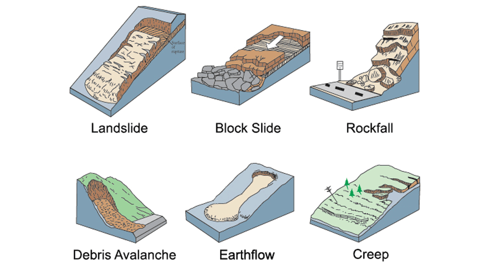
Common types of landslides. Modified from original image by USGS (public domain).
These events occur when friction between the earth material (i.e., rock and soil) and the slope is overcome, allowing the earth material to fail and move downslope. Landslides may be triggered by high rainfall, earthquakes, erosion, deforestation, groundwater pumping, or volcanic eruptions. They may occur rapidly, such as in some mud and debris flows, or they can be as slow as soil creep: slow land movement that usually does not cause loss of life, but can still destroy roads and buildings. In mountainous areas, avalanches, landslides, and rockfalls can be dangerous, moving downslope and then crossing roads and moving into areas that contain homes and other buildings. In the Rocky Mountains, every year at least one road will be temporarily closed as the result of an avalanche, earth movement, or rockfall event. Mass wasting events can also dam streams and rivers, creating lakes. If such dams fail, a flood will result somewhere downstream.
Landslides are common in mountainous regions of the Northwest Central thanks to a combination of steep terrain, poorly consolidated sediments, and tectonic activity.
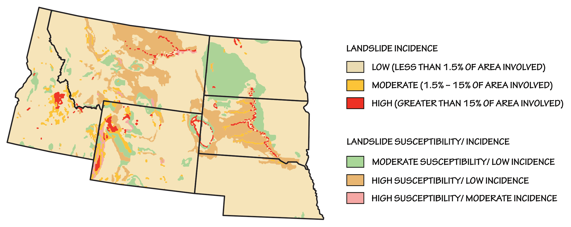
Landslide incidence and risk in the Northwest Central. Adapted from image by USGS (public domain).
They often occur in high glacial valleys with little vegetative cover. In the winter, many of the same mountainous areas that are prone to landslides during the year are subject to avalanches—rapid flows of snow, ice, and rock. Avalanches occur when the strength of the snow is overcome, or when a weak layer in the snow fails. These snow failures can result from storms, warming weather, sunny slopes, earthquakes, and people moving over the snow. Thousands of avalanches occur every winter in the mountains of Idaho, Montana, and Wyoming.
In Montana, landslides are among the state’s most common geologic hazards. The largest landslide in Montana history, triggered by the Hebgen Lake Earthquake of August 1959, carried 80 million tons of mud, rock, and debris down Sheep Mountain at an estimated 160 kilometers per hour (100 miles per hour).
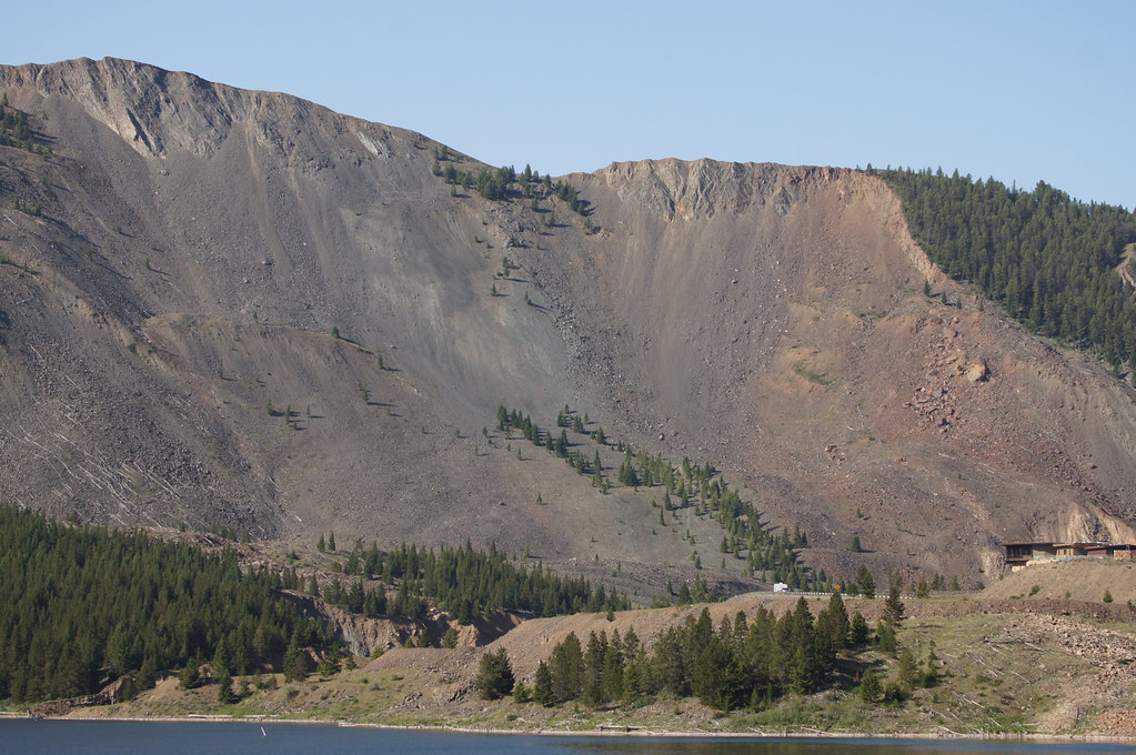
Damage from the Hebgen Lake Landslide is still visible today in Madison Valley, Montana. Photograph by "Tjflex2" (Flickr; Creative Commons Attribution-NonCommercial-NoDerivs 2.0 Generic license).
The slide killed 28 people and buried sections of Montana Highway 287 beneath almost 122 meters (400 feet) of rock, as well as formed a major dam across the Madison River.
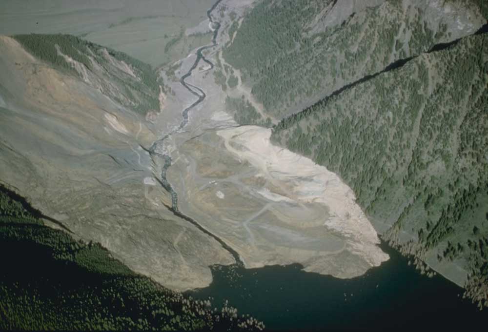
The landslide dam that led to the formation of Quake Lake (also known as Earthquake Lake). Today, the lake is 58 meters (190 feet) deep and 10 kilometers (6 miles) long. Photograph by USGS (public domain).
Landslides are also common occurrences in the mountains of Wyoming. In 1925, more than 38 million cubic meters (50 million cubic yards) of waterlogged soil was dislodged from a mountainside, crossed the Gros Ventre River, and moved 90 meters (300 feet) up the other side of the valley. The landslide blocked the river, creating Lower Slide Lake. Two years later, the dam failed, and the subsequent flash flood killed six people and destroyed a nearby town.
In Idaho, a variety of geological features combine to increase the likelihood of slope failure. Throughout the Snake River Plain and Columbia Plateau, basalt is interbedded with unconsolidated sediments, fractured metamorphic rocks, and loose volcanic material along deep canyons. Rocks fractured by folding and faulting are common, and ice-age floods deposited loose gravel and sand as well as undercut slopes. All these factors contribute to slope instability, and tremors from earthquakes associated with Idaho’s several fault lines often produce landslides throughout the state. Intense storms and heavy winter rains, generated by moisture carried eastward from the Pacific Ocean, can also waterlog soils and lead to mudflows or debris flows.
Mudflows or earthflows are fluid, surging flows of debris that have been fully or partially liquefied by the addition of water. They can be triggered by heavy rainfall, snowmelt or high levels of ground water flowing through cracked bedrock. High groundwater pressures and soil liquefaction due to nearby roadwork are thought to have generated the 1998 mudflow in Bonners Ferry, Idaho, in which 306,000 cubic meters (400,000 cubic yards) of earth materials flowed across Highway 95 and a Union Pacific railway track, burying more than a million dollars’ worth of equipment.
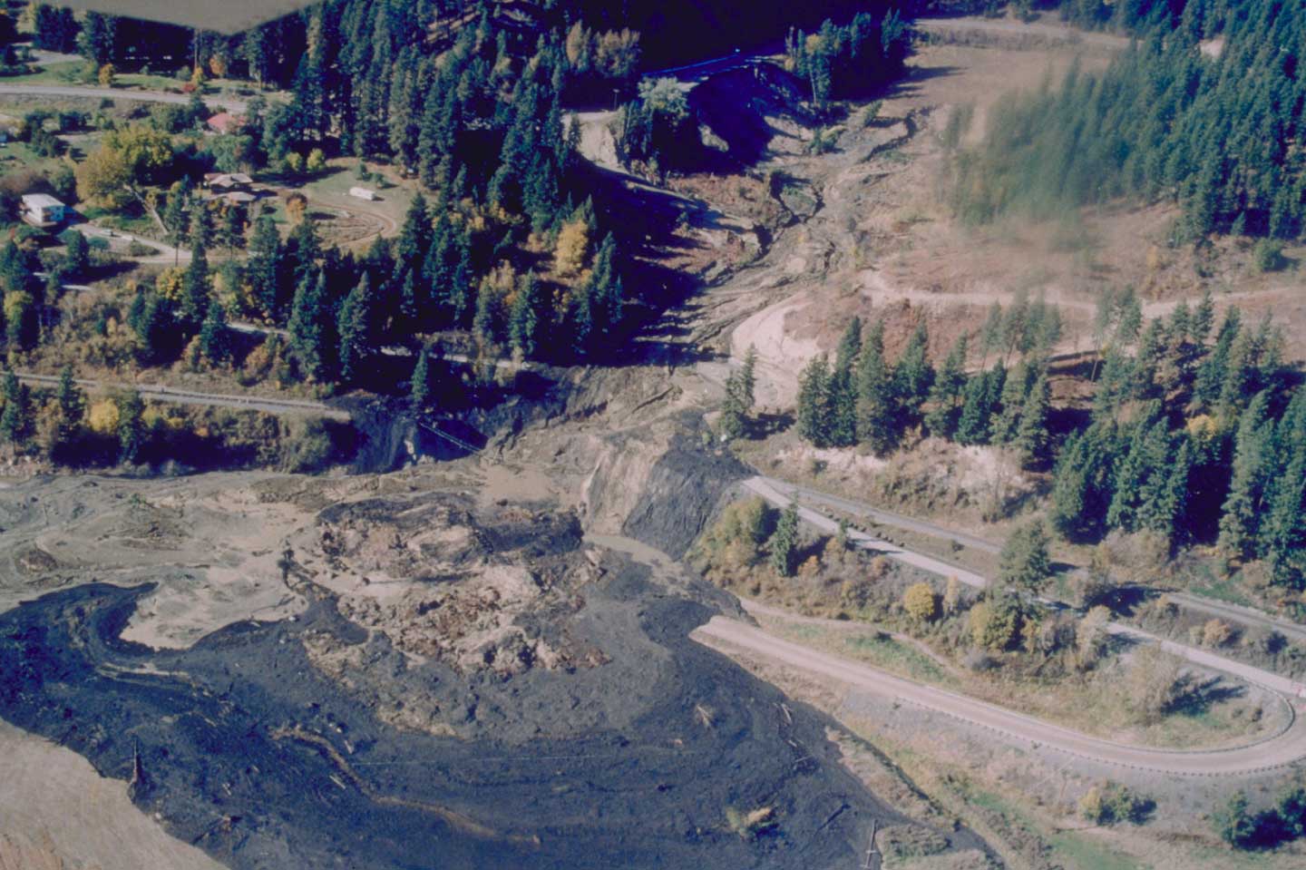
Mudflow in Bonners Ferry, Idaho. Photograph by D. Krammer, NOAA/NGDC (public domain).
Debris flows are a dangerous mixture of water, mud, rocks, trees, and other debris that moves quickly down valleys. The flows can result from sudden rainstorms or snowmelt that creates flash floods. In Glacier National Park, Montana, debris flows regularly occur where rock fragments like talus have built up on steep slopes and cliff faces. These debris flows can travel hundreds of meters (feet), and regularly impact trails and roads within the park.
Slumps and creep are common problems in parts of the Northwest Central with a wetter climate and/or the presence of unstable slopes, such as North Dakota’s Red River Valley, the Fort Randall Reservoir in South Dakota, and the Niobrara River in Nebraska. These areas contain expansive soils generated from clay-rich shales. Certain clay minerals can absorb water and swell up to twice their original volume―an amount of expansion that can exert enough force to cause damage, such as cracked foundations, floors, and basement walls. An estimated $9 billion of damage to infrastructure built on expansive clays occurs each year in the United States. In addition, when the clay dries and contracts, the particles settle slightly in the downhill direction. This process can cause soil creep, a slow movement of land that causes fences and telephone poles to lean downhill, while trees adjust by bending uphill.
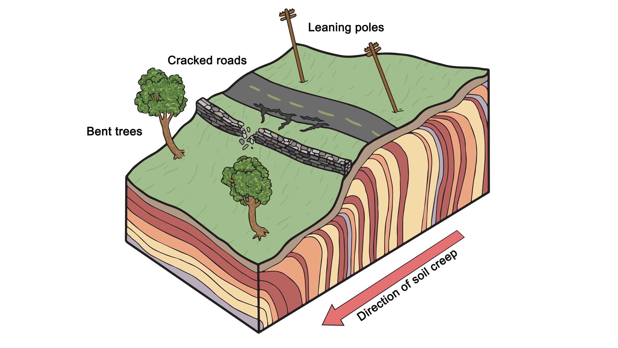
Some influences of soil creep on surface topography. Image by Wade Greenberg-Brand; modified for the Earth@Home project.
Human development can exacerbate this process when homes are built along river bluffs, disturbing vegetation that would otherwise stabilize the slope and adding water to the land in the form of yard irrigation or septic systems.
Slumping occurs when expansive minerals are present on steeper slopes, and involves the downward movement of a larger block of material along a surface that fails when the weight of the saturated soils can no longer be supported. Thanks to rain and heavy spring snowmelt runoff, slumps are a significant problem in some areas of North Dakota. In 2011 alone, this type of mass wasting caused more than $3 million of damage to roads and trails in Theodore Roosevelt National Park. Slumping is common near roads and highways throughout the state, thanks to the presence of steeper hills, roadcuts, and construction.
While expansive soils can be found all over the US, nearly every state in the Northwest Central has bedrock units or soil layers that are possible sources, with central Montana, North Dakota’s Red River Valley, and South Dakota’s Cretaceous shales being the most susceptible.
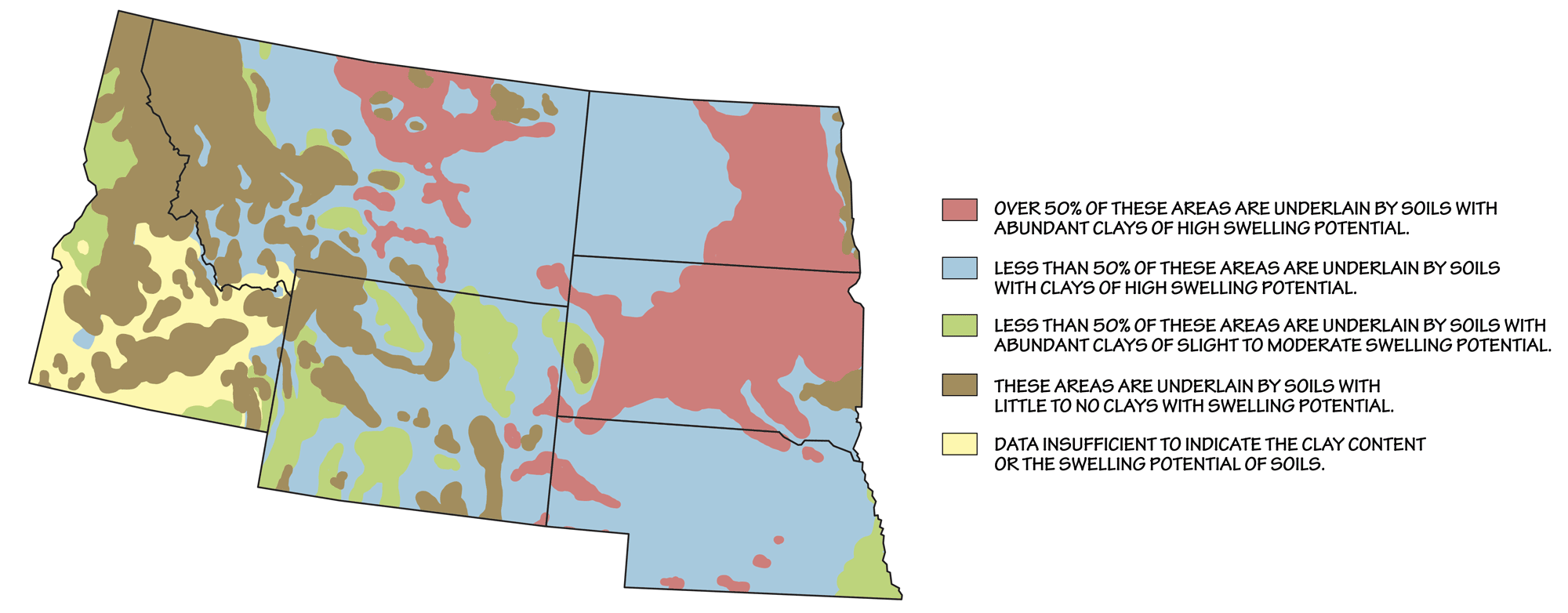
Approximate distribution of expansive soils in the Northwest Central US. This map is based on the distribution of types of bedrock, which are the origin of soils produced in place. (Where substantial fractions of the soil have been transported by wind, water, or ice, the map will not be as accurate.) Map by Wade Greenberg-Brand, adapted from image by USGS.
Significant or repeated changes in moisture, which can occur in concert with other geologic hazards such as earthquakes, floods, or landslides, greatly increase the hazard potential of expansive soils. The key to reducing this hazard is to keep the Damage to life and property from mass wasting events can be reduced by avoiding landslide hazard areas or by restricting access to known landslide zones. Hazard reduction is possible by avoiding construction on steep slopes or by stabilizing the slopes. There are two main ways to accomplish stabilization: 1) preventing water from entering the landslide zone through runoff, flooding, or irrigation and 2) stabilizing the slope by placing natural or manmade materials at the toe (bottom) of the landslide zone or by removing mass from the top of the slope.
Karst and sinkholes
Karst topography forms in areas where the underlying bedrock is composed of material that can be slowly dissolved by water. Examples of this type of sedimentary rock include carbonate rocks such as limestone, halite, gypsum, dolomite, and anhydrite. Carbonate rocks may develop karst and other dissolution features because of circulating groundwater that has been made slightly acidic through the presence of dissolved carbon dioxide (which creates carbonic acid that reacts with the rock, dissolving it). Sinkholes and caverns can form, creating potential hazards (i.e., the land surface could subside or collapse into the underground openings). This may principally occur in areas where cavities filled with water are emptied through groundwater withdrawal or other natural processes, resulting in the cavities being filled with air and reducing support for the overlying rock. Karst is not overly prevalent in the Northwest Central, but it is found in abundance throughout the Black Hills of South Dakota, and is scattered throughout several other states.
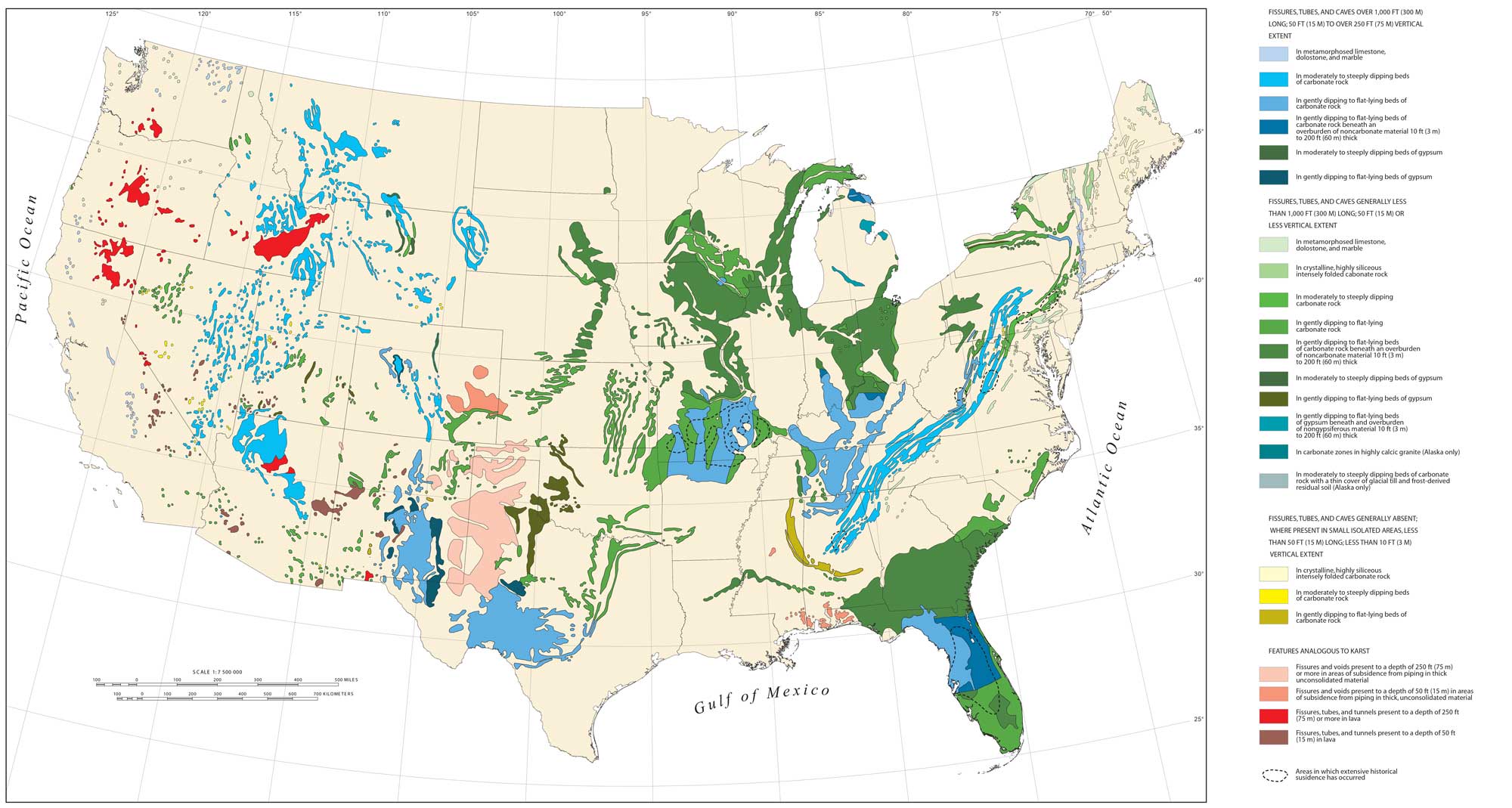
Areas of karst in the continental US associated with carbonate and evaporate rocks. Adapted from image by Tobin and Weary, USGS (public domain).
The Black Hills are surrounded and underlain by thick layers of Mississippian to Jurassic anhydrite and gypsum, which contain abundant karst features due to dissolution from groundwater and rain. Sinkholes are commonplace, ranging in size from small holes of a few meters (feet) across to large pits as wide as 140 meters (460 feet). The presence of other easily dissolved carbonate layers, laid down in Paleozoic and Mesozoic inland seas, has led to a variety of caves and small sinkholes found throughout the Northwest Central US. For example, the Little Belt Mountains in central Montana are underlain by a thick layer of limestone (the Madison Limestone) laid down in the Mississippian. The Belt Meteor Crater southeast of Great Falls, Montana is a sinkhole in the Madison Limestone, rather than an impact site.
The Belt Meteor Crater southeast of Great Falls, Montana, is a sinkhole in the Madison Limestone measuring 10 meters (35 feet) deep and 30 meters (100 feet) across. Video: "Scenes from the Belt Meteor Crater" by Rod Benson (YouTube).
In Idaho, volcanic pseudokarst dominates the Snake River Plain. This type of topography is not technically karst—instead of forming through the dissolution on carbonate bedrock, these fissures, sinkholes, and caves were created by the extrusion of liquid lava. While sinkholes in volcanic pseudokarst are rare, they tend to be related to the collapse of old lava tubes. Because karst terrain is very porous and fractures easily, groundwater pollution can be a serious problem. Contaminants that might otherwise be filtered through the sedimentary rock are quickly transported into aquifers by runoff. The hazards of pollution are increased by rampant industrial, agricultural, and residential development over karst features.
Radon
Radon concentrations are generally high throughout the Northwest Central U.S.
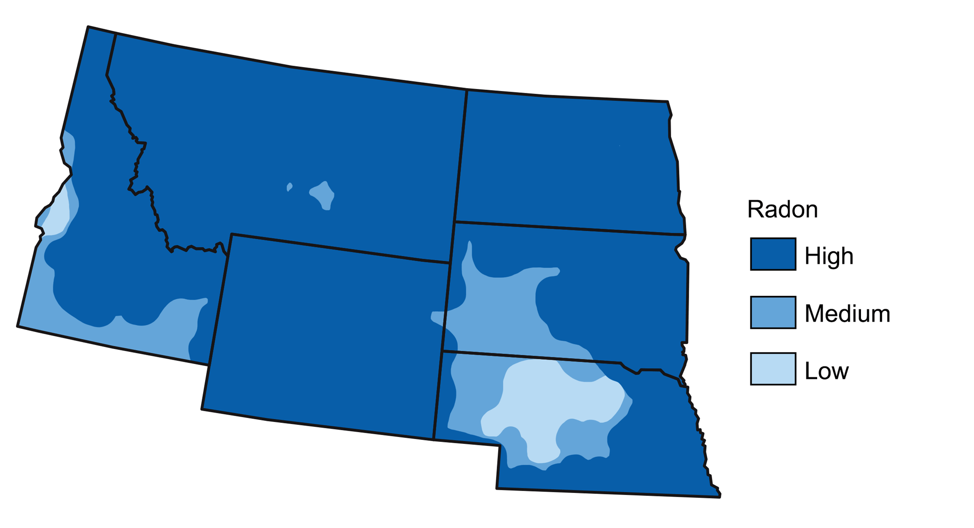
Radon risk levels at the surface in the Northwest Central United States. Image by Wade Greenberg-Brand, adapted from image by EPA (public domain).
Uranium is relatively concentrated in the granites and metamorphic rocks of the Rocky Mountains, Black Hills, and Basin and Range, as well as in the sediments eroded from these areas. Uranium is also concentrated in some Paleogene sandstones and coal deposits. Taken together, these areas account for a broad part of the Northwest Central.
There are, however, areas that are moderate or low in radon—the Sandhills of northwest Nebraska have the lowest radon concentrations in the Northwest Central. This area is composed of windblown sediment that was separated from the clay and heavier minerals that contain relatively high amounts of uranium. In the Columbia Plateau, radon associated with basalt bedrock is also lower in concentration than that found in the mountains farther north.
Floods
Major floods in the Northwest Central generally occur along the Missouri River or its tributaries, and these events are more frequent in spring and fall after periods of heavy or sustained rains when stream levels rise rapidly.
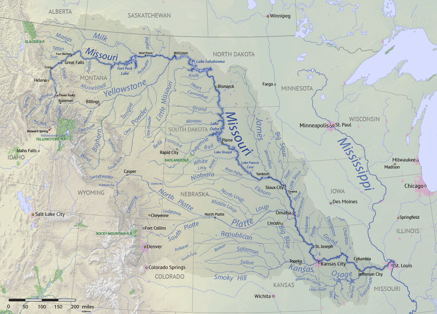
The Missouri River watershed. Image by "Shannon1" (Wikimedia Commons; Creative Commons Attribution-Share Alike 4.0 International license).
Flooding in the Northwest Central generally occurs through flash floods, periods of long-term rainfall, spring snowmelt, or some combination of these factors. While flash floods tend to impact a smaller area than do long-term rainfall and snowmelt, they can be especially dangerous because they arise so suddenly. Famous flash floods include the Republican River Flood of 1935 in Nebraska, when 46–61 centimeters (18–24 inches) of rain fell on May 30th that year; the Cheyenne Flood of 1985, when 18 centimeters (7 inches) of rain fell in three hours on August 1st in Cheyenne, Wyoming; and the Black Hills Flood of 1972 on Rapid Creek in Rapid City, North Dakota, when 38 centimeters (15 inches) of rain—approximately one million metric tons overall—fell over six hours from June 9–10, 1972. The Black Hills Flood is considered to be one of the most significant floods in US history: a surge caused a breach in the Canyon Lake Dam, releasing water into Rapid City and killing 238 people, destroying 1335 homes, and causing over $900 million (adjusted) in damage.
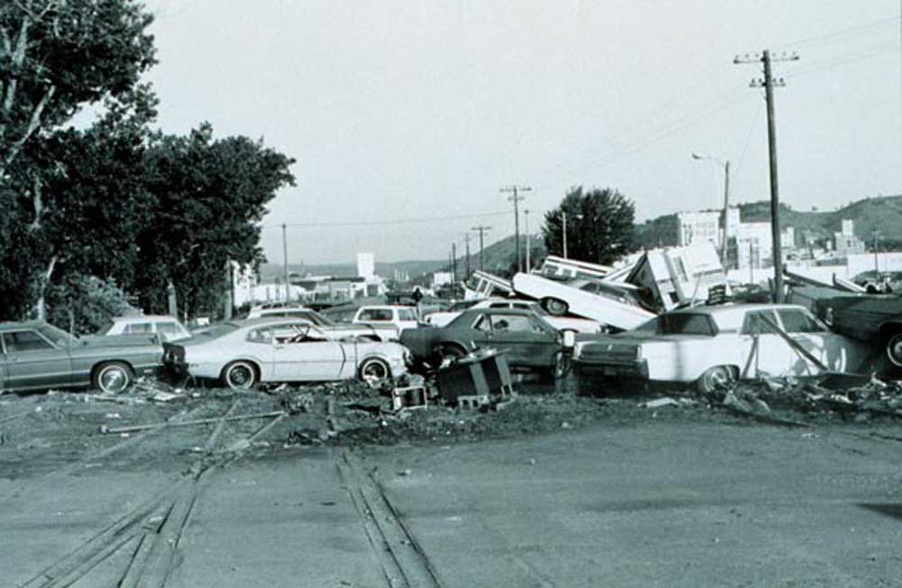
A pile of cars swept away by the 1972 Black Hills Flood. This event destroyed over 5000 vehicles. Photograph by NOAA (public domain).
There are numerous recorded instances of flooding on the Missouri River due to long-term rainfall, contributing to subsequent flooding downstream in St. Louis and into the Mississippi. The Great Flood of 1993, when floodwaters traveled down the Missouri River from South Dakota and Nebraska into Iowa, Kansas, and Missouri, flooded over 4 million hectares (11 million acres) and caused at least 50 deaths and over $24 billion (adjusted) in damage. The 2011 Missouri River Flood, caused by high winter snowfall in Montana and Wyoming followed by large spring rainfall on the plains of Montana, inundated roads and buildings and threatened towns and cities along the river from Montana to Missouri.
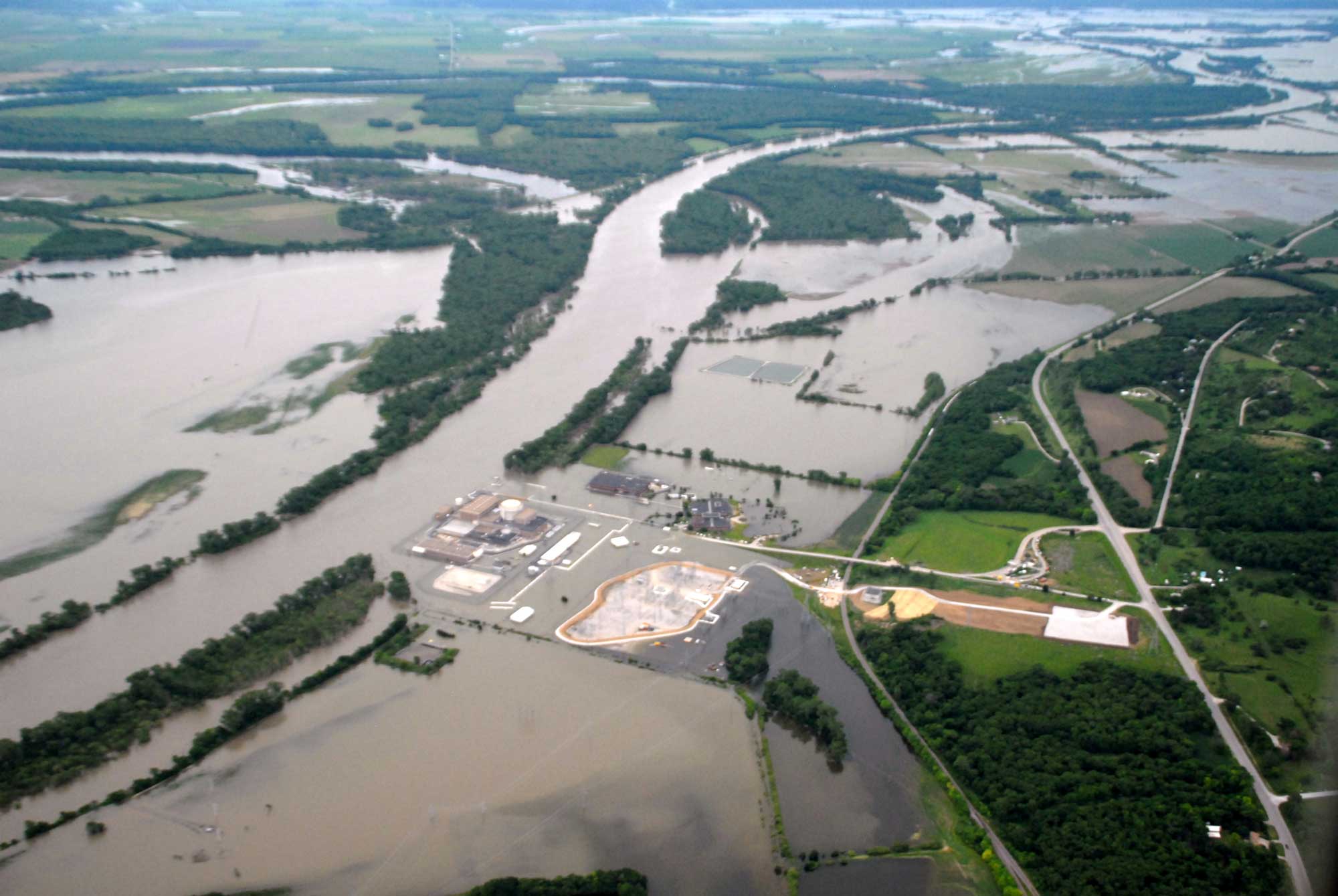
The Fort Calhoun Nuclear Reactor and surrounding areas of Nebraska were inundated by floodwater during the 2011 Missouri River Flood. Photograph by US Army Corps of Engineers (public domain).
The Great Flood of 1881 in South Dakota and Nebraska (notably including Omaha) was caused by ice jams along the Missouri River, and the April 1997 Red River Flood of Grand Forks, North Dakota was due to abundant snowfall combined with heavy rain during the previous fall.
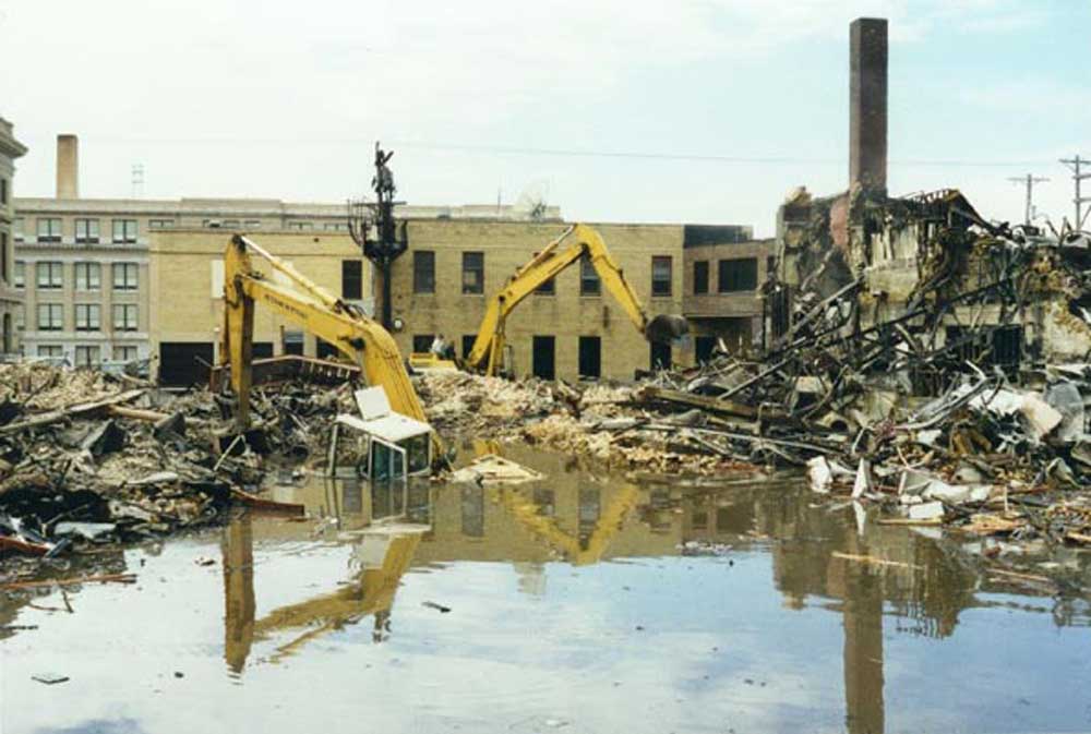
Wreckage in Grand Forks, North Dakota, after the 1997 Red River Flood. Image by USGS (public domain).
Devils Lake in North Dakota is known for dramatic annual changes in water level depending on local precipitation, and has gained a net increase of about 40 meters (130 feet) in water depth since 1940. The lake has quadrupled in size over the last two decades, growing from 18,000 hectares (44,000 acres) in 1994 to about 82,000 hectares (202,000 acres) today.
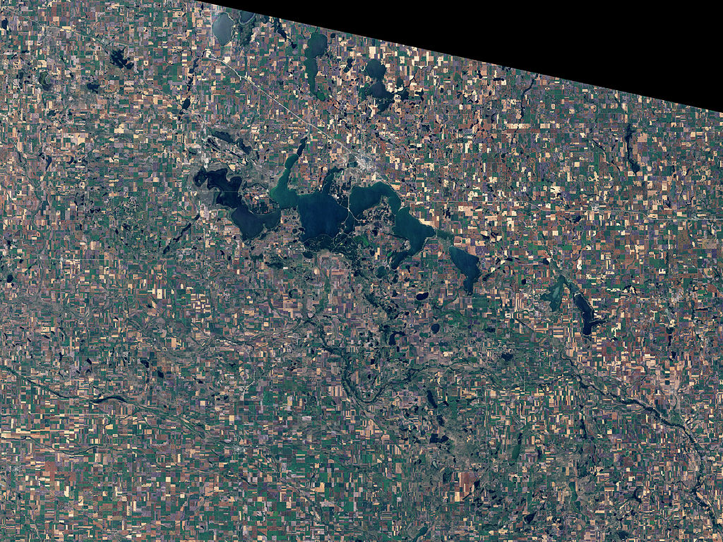
Devils Lake, North Dakota in 1984. Image by NASA (Wikimedia Commons; public domain).
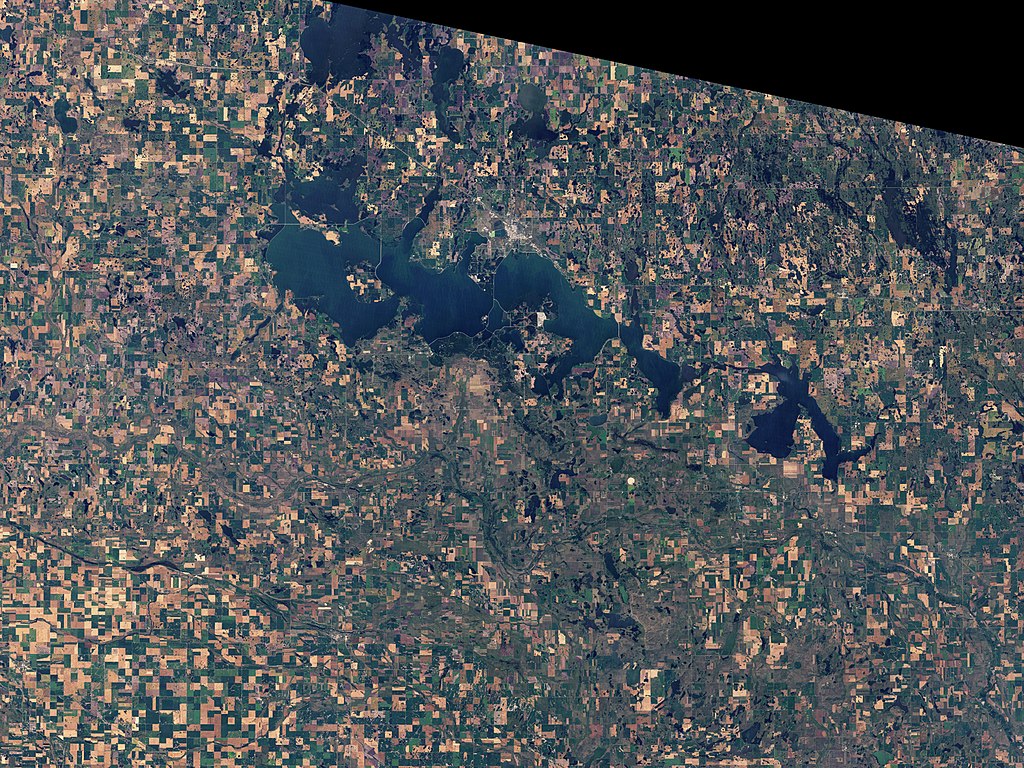
Devils Lake, North Dakota in 2009. Image by NASA (Wikimedia Commons; public domain).
Devils Lake is a closed drainage basin with no natural outlets, and water can therefore leave its confines only through evaporation, ground infiltration, or overflow. During one period of especially rapid increase, rainfall between 1993 and 1999 caused the lake’s water level to rise about 20 meters (66 feet), flooding 28,000 hectares (70,000 acres) of farmland, displacing 300 homes, and costing about $450 million to mitigate the flooding. There has been substantial controversy about the ecological impacts of proposed mechanisms to create an outlet that would offset further lake rise, partially focused on where to divert the water and the consequences of potentially moving invasive species into other basins. Flooding from the lake today continues to affect agriculture and infrastructure in the surrounding area.
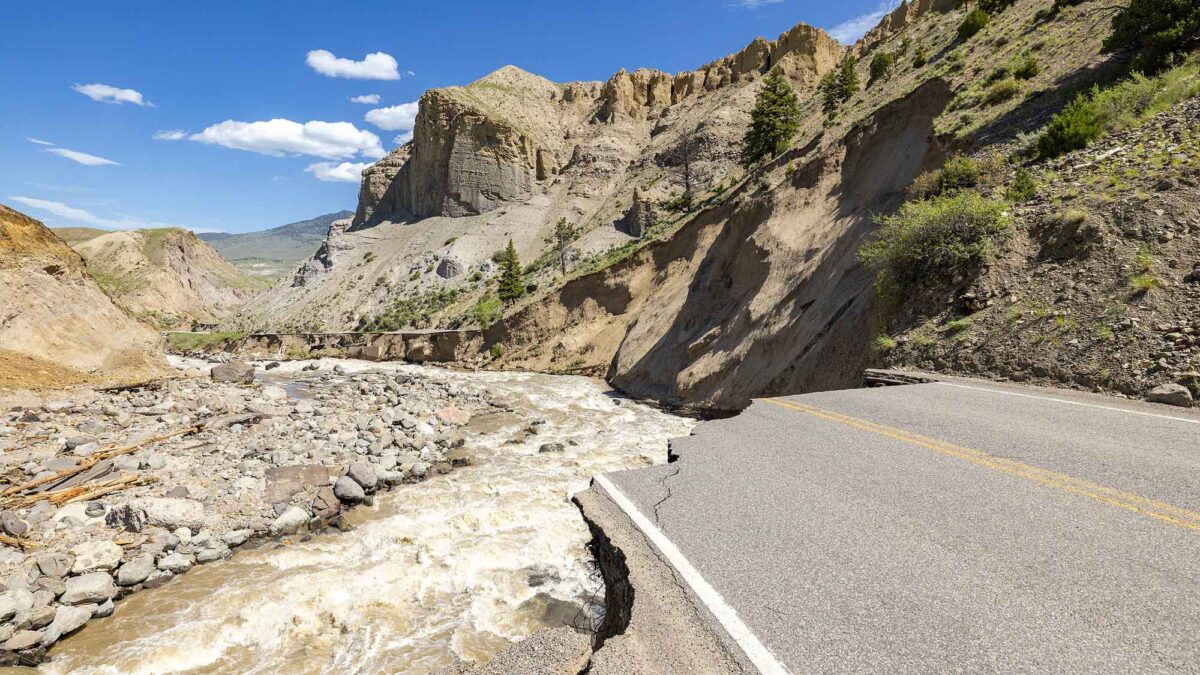
Recent flooding on the Yellowstone River in June 2022 caused significant damage near Yellowstone National Park, forcing the park to close all of its entrances and evacuation of all of its guests.
"What Really Happened During the Yellowstone Park Flood?" by Practical Engineering (YouTube).
Weather hazards
Storms, Tornadoes, and Derechos
Several types of severe storms present challenges to people living in the Northwest Central. Summer brings severe thunderstorms associated with cold fronts. Fall and spring can bring ice storms, while winter brings snow and, in some cases, blizzard conditions. In October 2013, for example, a major blizzard affected the Northwest Central and much of the Midwest, dumping up to 1.5 meters (5 feet) of snow across the Great Plains. The snow affected 5000 ranches in South Dakota, scattering and killing herds of cattle and sheep, as well as disabling power for more than 20,000 homes and trapping people inside their cars. The storm system’s winds blew up to 112 kilometers per hour (kph) (70 miles per hour [mph]), generating 22 separate tornados as well as severe thunderstorms and ice storms.
Rainstorms arise where colder air from higher latitudes abruptly meets warmer air. Severe thunderstorms are a common occurrence for people living in the Northwest Central because the conditions over the Great Plains are perfect for the development of severe weather. The flat, open fields are warmed by the summer sun, which sits high in the sky during this time of year. This results in large temperature differences when cold air masses move across the country. At the boundary between warmer and cooler air, buoyant warm air rises, and then cools because air pressure decreases with increasing height in the atmosphere. As the air cools, it becomes saturated with water vapor, condensation occurs, and clouds begin to form. Because liquid water droplets in the clouds must be very small to remain suspended in the air, a significant amount of condensation causes small water droplets to come together, eventually becoming too large to remain suspended. Sufficient moisture and energy can lead to dramatic rainstorms. Because warm air has a lower pressure relative to cold air, and the movement of air from areas of high pressure to areas of low pressure generates wind, the significant difference in air pressure associated with these boundaries and rainstorms also generates strong winds. Flat regions, such as the Great Plains, allow winds to move unimpeded by topography, and are often subject to severe thunderstorms.
While severe thunderstorms are common in some parts of the Northwest Central, two less common storm hazards have the potential to cause serious property damage and endanger lives: derechos and tornados. Both of these storm events are associated with wind shear, which occurs when the wind’s speed or direction changes with increasing height in the atmosphere. Wind shear can happen when a cold front moves rapidly into an area with very warm air. There, the condensing water droplets mix with the cooler, drier air in the upper atmosphere to cause a downdraft. When these downdrafts are very powerful, they can cause a derecho, or a set of powerful straight-line winds that exceed 94 kph (58 mph) and can often approach 160 kph (100 mph). These powerful windstorms can travel over 400 kilometers (250 miles) and cause substantial wind damage, knocking down trees and causing widespread power outages. The lightning associated with these intense storms can cause both forest fires and house fires. Approximately one derecho every two years or so will occur in easternmost South Dakota and Nebraska, and they appear with decreasing frequency as one travels westward.
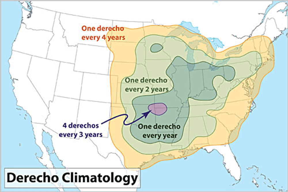
Derecho frequency in the continental United States. Map by NOAA (public domain).
“Tornado Alley” is the nickname for an area, extending from Texas to Minnesota, that experiences a high number of exceptionally strong tornados due to its flatter topography and high incidence of severe thunderstorms. Both Nebraska and South Dakota reside within Tornado Alley, leading to more tornados in this part of the Northwest Central.
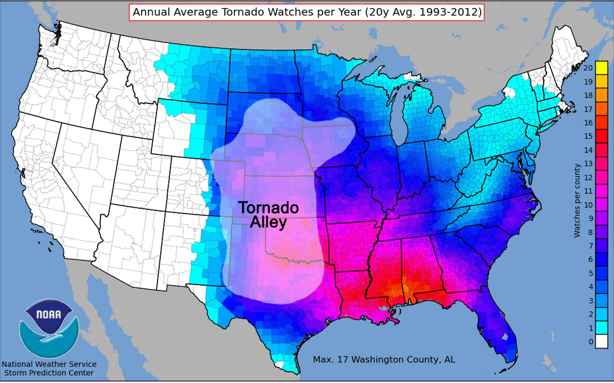
Twenty-year average yearly tornado watches in each county of the United States between 1993 and 2012. Tornado Alley is identified. Map by NOAA (public domain) modified for the Earth@Home project.
From 1991 to 2010, for example, an annual average of 57 and 36 tornados occurred in Nebraska and South Dakota, respectively.
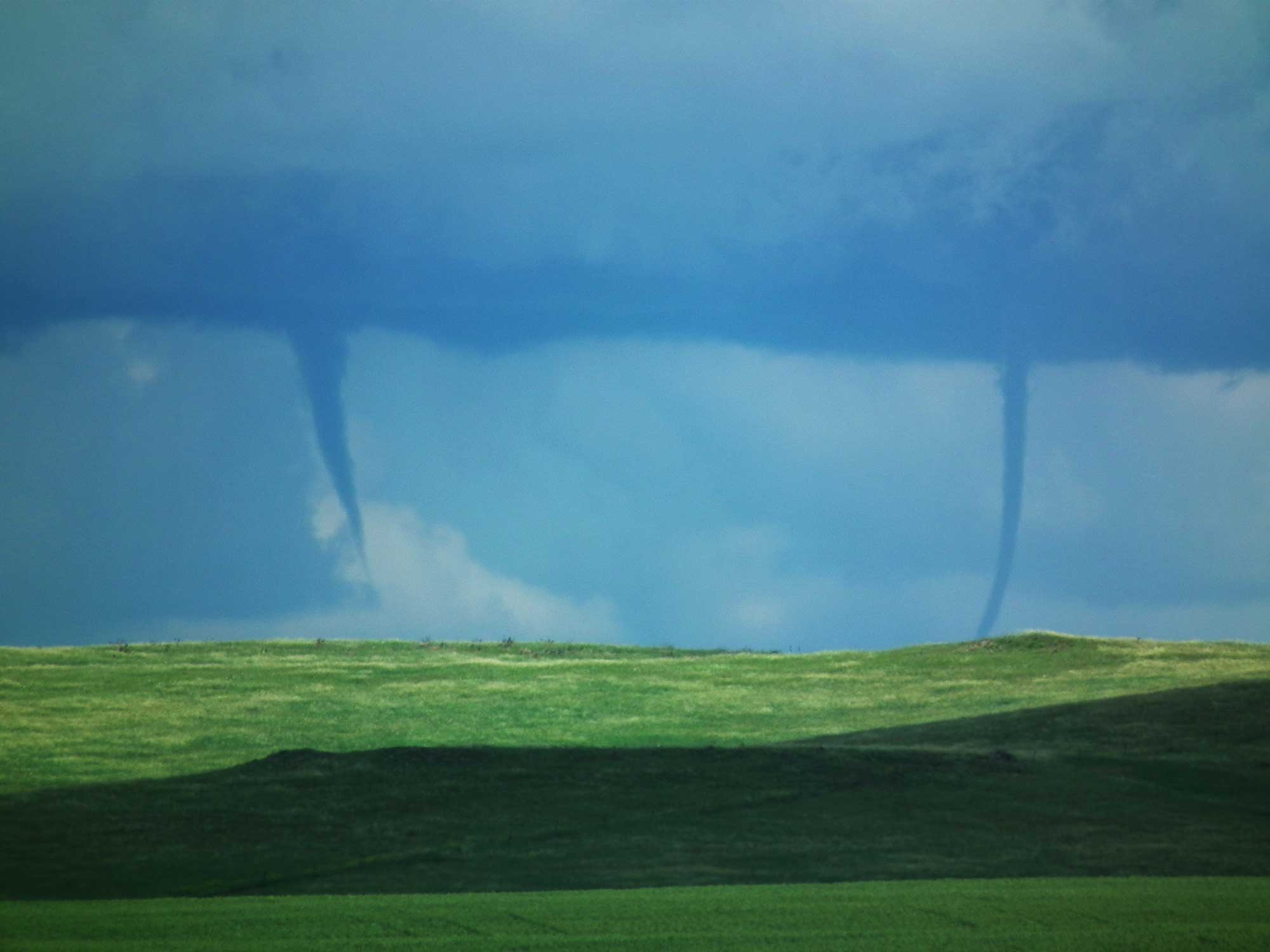
Two tornados touch down simultaneously in a South Dakota field between the towns of Enning and White Owl. Photograph by Dan Udager, USDA NRCS (public domain).
To the west and north of Tornado Alley, fewer tornado strikes occur, with an annual average of 32, 12, 10, and 5 striking North Dakota, Wyoming, Montana, and Idaho, respectively. The boundaries of Tornado Alley vary in application, depending on whether the frequency, intensity, or number of events per location are used to determine the area’s borders.
Extreme Temperature and Drought
During the first half of 2012, North America experienced a heat wave that set thousands of temperature records, particularly in the Midwest and Northwest Central and parts of central Canada.
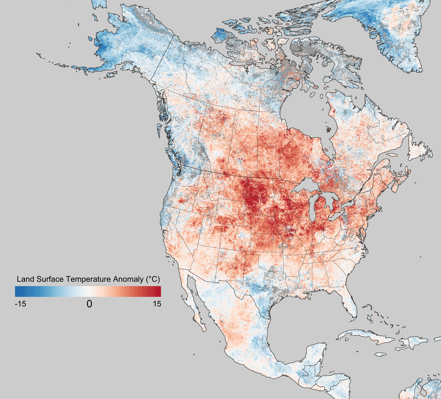
Land surface temperature anomalies in March 2011. Red areas represent above average temperatures and blue areas represent below average temperatures. Image by NASA (public domain).
Within the Northwest Central, the Great Plains region experienced some of the most anomalous temperatures in the country. The event was attributed to persistent low-level winds blowing warm air from the Gulf of Mexico toward Canada. Like other climate events, the heat wave could not be directly attributed to global warming, but climate change is thought to have increased the event’s severity by 5 to 10%. The heat wave was also associated with the start of a serious drought in the central United States.
While high temperatures can be directly dangerous, a larger scale hazard arises when these temperatures are coupled with a lack of precipitation in an extended drought period. Most famously, high temperature and drought in the 1930s, combined with deep plowing that removed moisture-trapping grasses, led to the Dust Bowl―dust storms that carried vast clouds of black dust across the Midwest and central US, greatly damaging both the ecology and agriculture across that portion of the country.
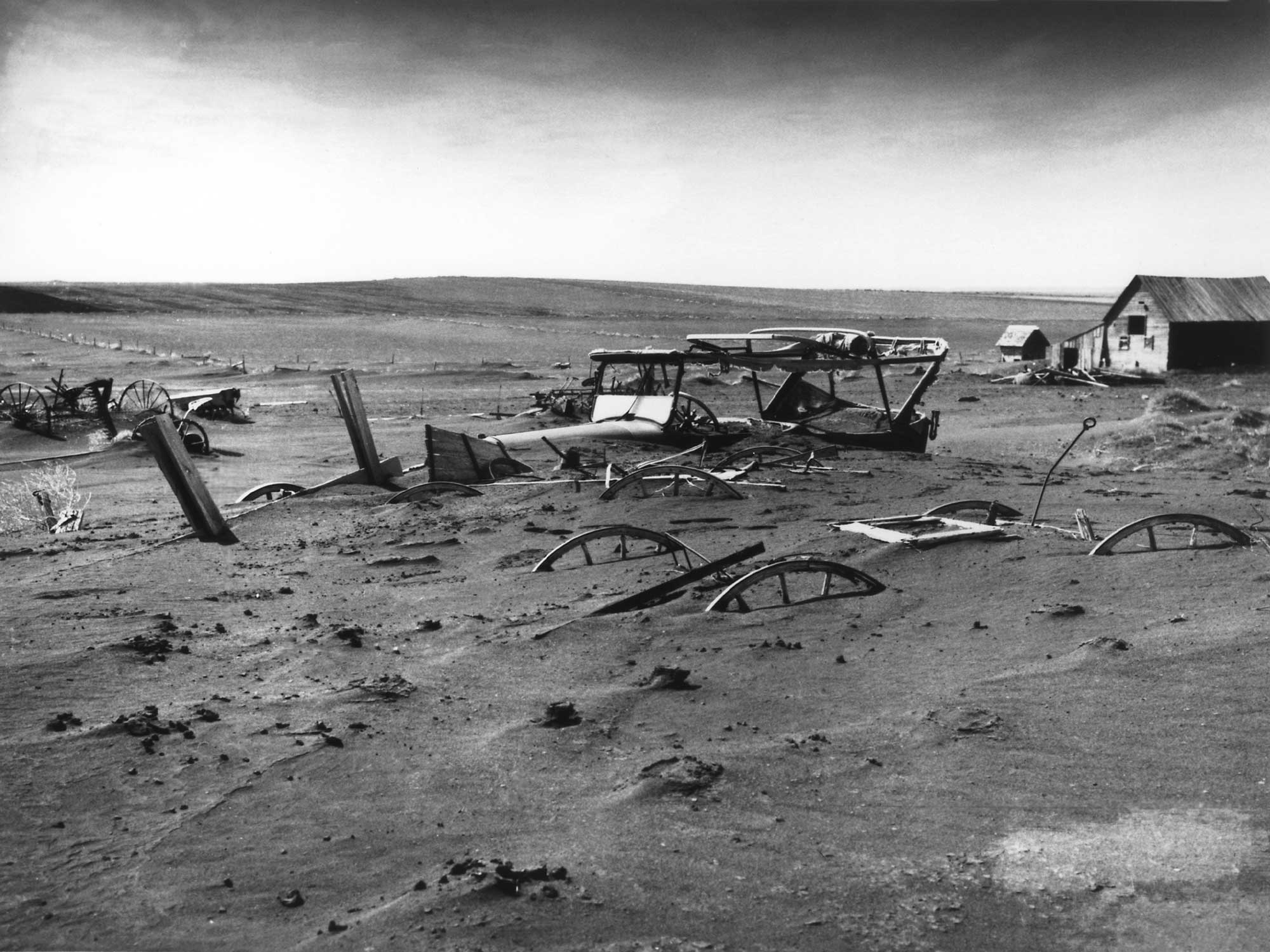
A car and other farm equipment lies buried following a dust storm near Dallas, South Dakota in 1936. Image from the USDA (public domain).
Although the Dust Bowl was most intense in the panhandles of Texas and Oklahoma, the event impacted agriculture throughout the Great Plains, including Nebraska and South Dakota. Dust storms destroyed topsoil, buried equipment and houses, and contributed to the incidence of lung disease.
Recently, a different extreme temperature phenomenon has made the news: the polar vortex. As the name implies, a polar vortex is a regularly occurring area of low pressure that circulates in the highest levels of the upper atmosphere. Typically, the polar vortex hovers above Canada. However, a pocket of the counterclockwise rotating, low-pressure center can break off and shift southward at a lower altitude, covering the northern United States with frigid air. The jet stream then shifts to a more southward flow than usual, and its chill can even reach the southern states. A polar vortex can lock the jet stream in this new pattern for several days to more than a week. In early January 2014, the polar vortex dipped low over the upper United States, bringing with it some of the coldest temperatures seen in over 20 years. Temperatures in North Dakota plummeted to −30°C (−23°F), with wind chills of up to −51°C (−60°F). The lowest temperature in the US― −34°C (−30°F)―was recorded near Poplar, Montana. Although the cold temperatures of a polar vortex can be uncomfortable and make traveling dangerous in the winter, the Northwest Central has not yet experienced any major economic or health-related impacts from this type of extreme weather event.
Climate change
It is important to understand that most of the extreme climate change in Earth’s history occurred before humans existed. That being said, the rapid release of carbon dioxide into the atmosphere from human activity is currently causing a global warming event. The seemingly slight increase in the average annual temperatures in the Northwest Central over the past 25 years has been accompanied by more frequent heat waves, shorter winters, and an increased likelihood of drought and wildfires.
Although wildfires can occur during any season, summer fires are the most common, since increased dryness contributes to fire risk. In June 2012, the Fontenelle wildfire in Wyoming’s Bridger-Teton National Forest consumed 25,990 hectares (57,324 acres) of forest after sparks from a downed power line ignited dry, dead timber. In August 2013, a lightning strike ignited the Bear Creek wildfire in Idaho, which burned more than 40,440 hectares (100,000 acres), threatened two popular ski resorts, and required the efforts of more than 1200 firefighters to combat the blaze. The 2012 fire season was among the worst on record in Wyoming, with more than 1300 fires burning about 240,000 hectares (600,000 acres) across the state, thanks to extremely dry conditions and swaths of dead trees killed by pine beetles.
Unfortunately, the Rocky Mountains’ rugged terrain can make fires even more difficult to extinguish. Water supply is also a critical issue for the Northwest Central States. Here, most water is obtained from precipitation, snowmelt, and runoff, which will dramatically decrease in quantity as temperature and aridity rise. In addition, Nebraska obtains much of its agricultural and drinking water from the Ogalalla aquifer, an underground layer of water-bearing permeable rock. Part of the High Plains aquifer system, this underground reservoir supplies vast quantities of groundwater to Nebraska as well as Texas, Oklahoma, and Kansas. As drought intensifies and temperature rises, the amount of water drawn from the aquifer (especially for agricultural irrigation) has increased, while the rate at which the aquifer recharges has decreased. The aquifer’s average water level has dropped by about 4 meters (13 feet) since 1950, and in some areas of heavy use, the decrease is as high as 76 meters (250 feet).
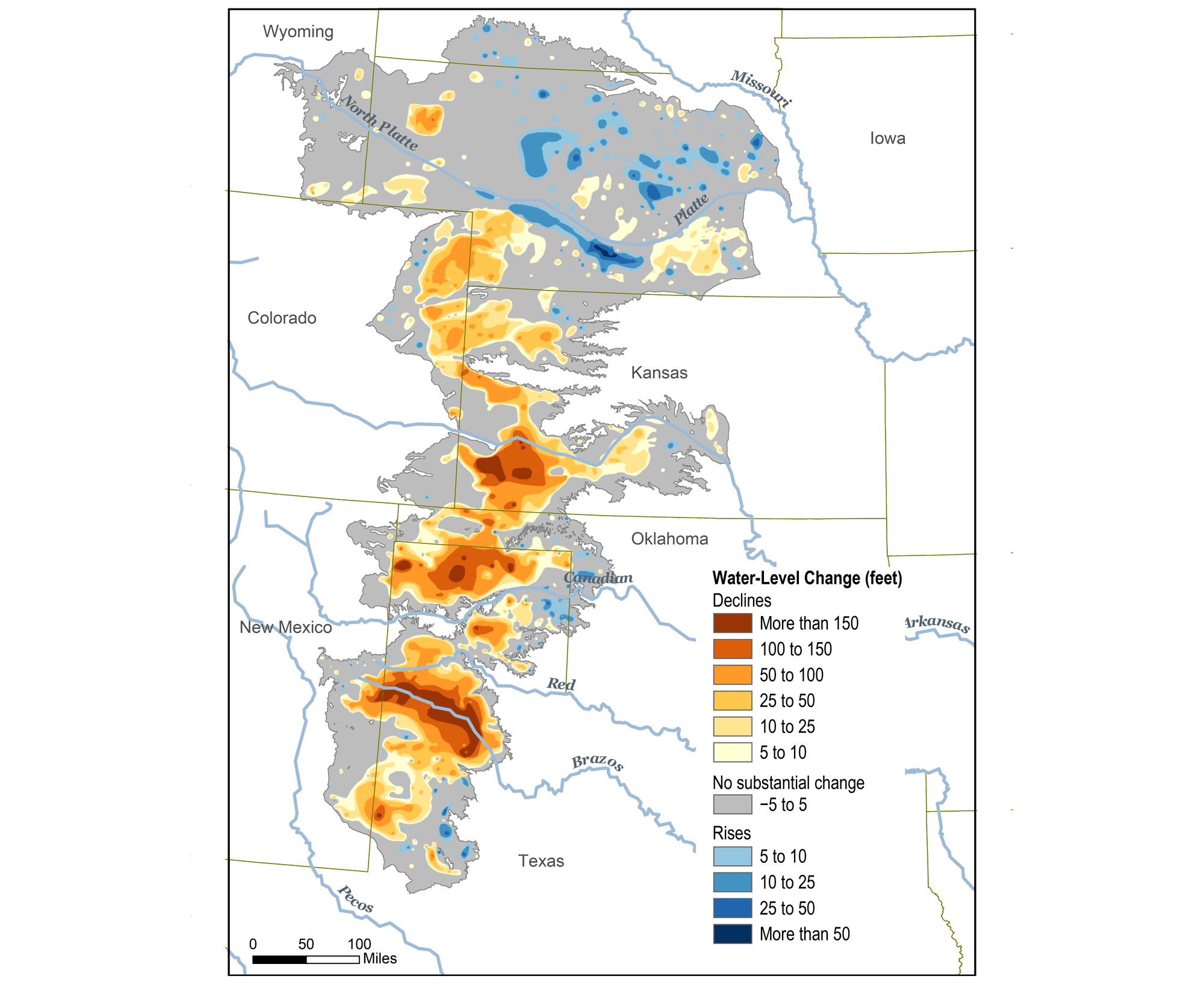
Original caption: "This map shows changes in Ogallala water levels from before the aquifer was tapped to 2015. Declining levels are red or orange, and rising levels are blue." Map from Climate.gov (NOAA).
However, the aquifer only replenishes at a rate no greater than 150 millimeters (6 inches) per year. While the portion of the aquifer beneath Nebraska has yet to be adversely affected, some estimates indicate that at its current rate of use, the entire Ogalalla aquifer could be depleted by as early as 2028, threatening human lives, our food supply, and the entire Great Plains ecosystem.
Another concern regarding hazards exacerbated by climate change in the Northwest Central is whether or not there has been or will be an increase in the number or severity of storms, including thunderstorms and tornados. According to NASA, the present data is inconclusive in terms of whether major storms are already more severe, but there is a greater than 66% chance that global warming will cause more intense storms in the 21st century. Since climate is a measure of weather averaged over decades, it might take many years to determine that a change has occurred with respect to these types of storms. Scientists are certain, however, that the conditions necessary to form such storms are becoming more favorable due to global warming.