

Page snapshot: Glaciers in the south-central United States, including evidence for glaciers and landscapes influenced by glaciers.
Topics covered on this page: Introduction; Glacial erratics; The Loess Hills; The coastline and glaciers; Resources.
Credits: Most of the text of this page is derived from "Glaciers in the South-central US" by Alex F. Wall and Robert M. Ross, chapter 6 in The Teacher-Friendly Guide to the Earth Science of the South Central US, edited by Mark D. Lucas, Robert M. Ross, and Andrielle N. Swaby (published in 2015 by the Paleontological Research Institution; currently out of print). The book was adapted for the web by Elizabeth J. Hermsen and Jonathan R. Hendricks in 2022. Changes include formatting and revisions to the text and images. Credits for individual images are given in figure captions.
Updates: Page last updated July 29, 2022.
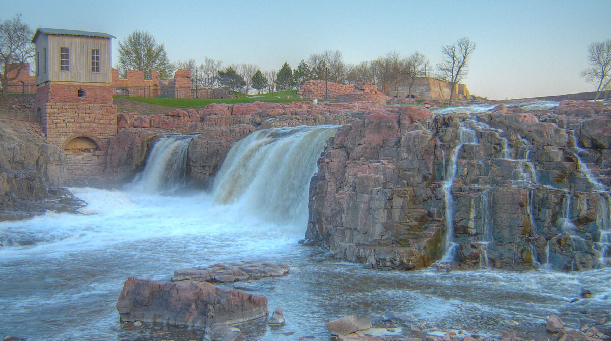
Image above: The falls at Falls Park on the Big Sioux River in Sioux Falls, South Dakota, flow over Sioux quartzite. Chunks of this quartzite was transported by glaciers and dropped in Kansas, where it forms striking fields of glacial erratics. Photo by Jerry (flickr, Creative Commons Attribution-ShareAlike 2.0 Generic license, image cropped and resized).
Introduction
Most people may not picture the South Central as an area that once contained glaciers, but the northern parts—northern Kansas and Missouri—were reached by the most extreme glacial advances of the late Pleistocene. Weathering and deposition indirectly associated with glaciation have occurred in other parts of this area. During the Quaternary period, which began just 2.6 million years ago and extends to the present, ice at times extended southward from the Hudson Bay area and over the northern United States. When the ice finally retreated, it deposited the rock and dirt it had been carrying, influencing the landscape long after the ice was gone.
Even during the most extreme intervals of Pleistocene glaciation, the Laurentide Ice Sheet (the northern hemisphere ice sheet) barely reached as far south as northern Missouri and Kansas. Glaciers that reached Kansas and Missouri flowed from centers of accumulation far to the north (in what is now Canada), and glacial growth southward through the Midwest was more a result of lateral flow than of direct precipitation from falling snow.
Glaciers that extended far enough to reach Kansas and Missouri only occurred during glaciations in the pre-Illinoian period, about 1.8 million to 302,000 years ago. There were perhaps five pre-Illinoian glaciations in Missouri, representing glaciations as recently as a few hundred thousand years ago, and two in Kansas, the most recent being about 600,000 years ago.
Although the remainder of the south-central U.S. was never covered by ice sheets, much of the area felt their effects. The area south of the ice sheet developed its own distinctive landscape and features due to its proximity to the ice margin. This unglaciated but still affected area is called a periglacial zone.
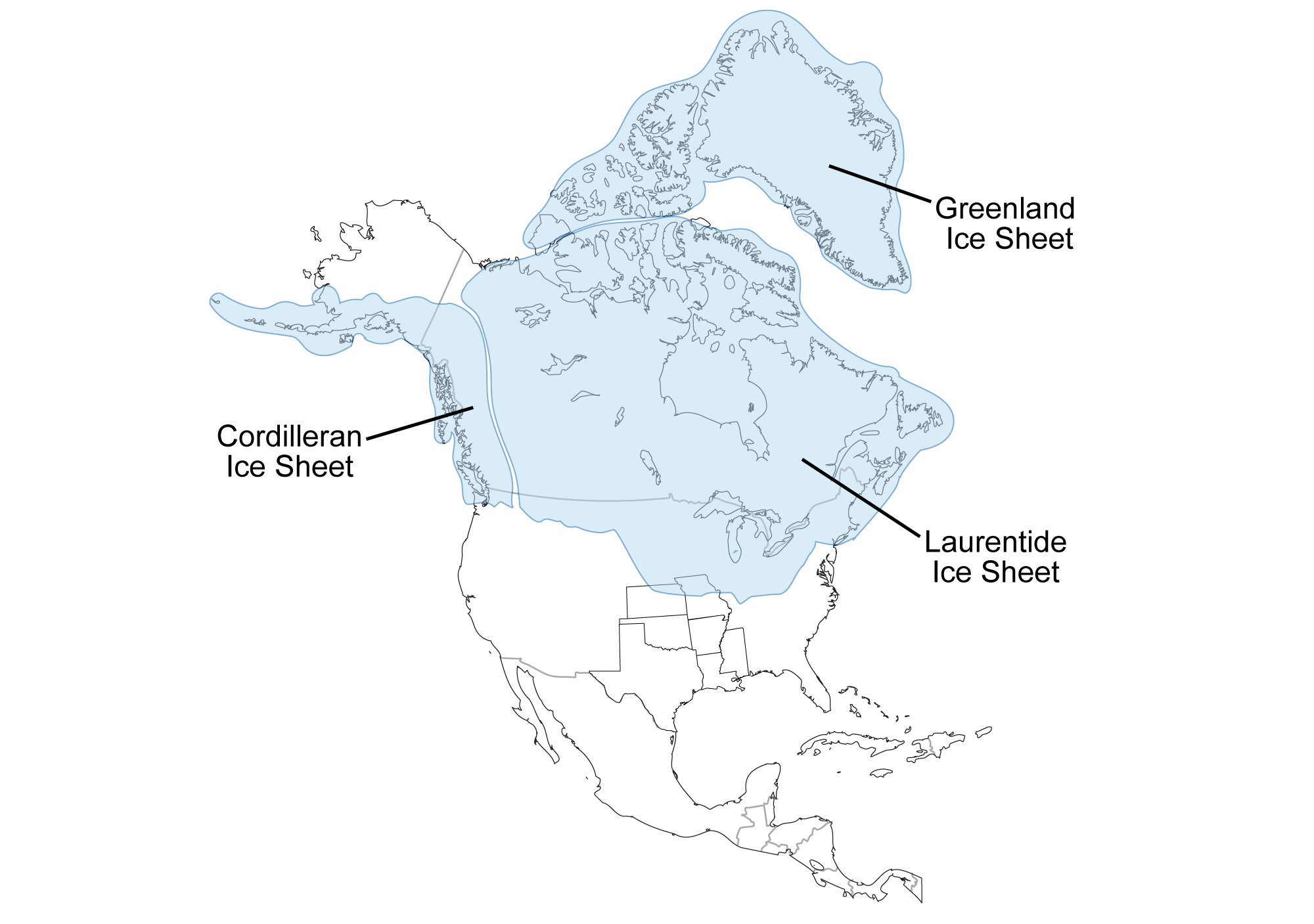
Southernmost extent of glaciation over North America, at a time when glaciers covered parts of northern Kansas and Missouri. Map by Wade Greenberg-Brand, adapted from an image by the Illinois Geological Survey, originally published in The Teacher-Friendly Guide to the Earth Science of the South Central US, modified for Earth@Home.
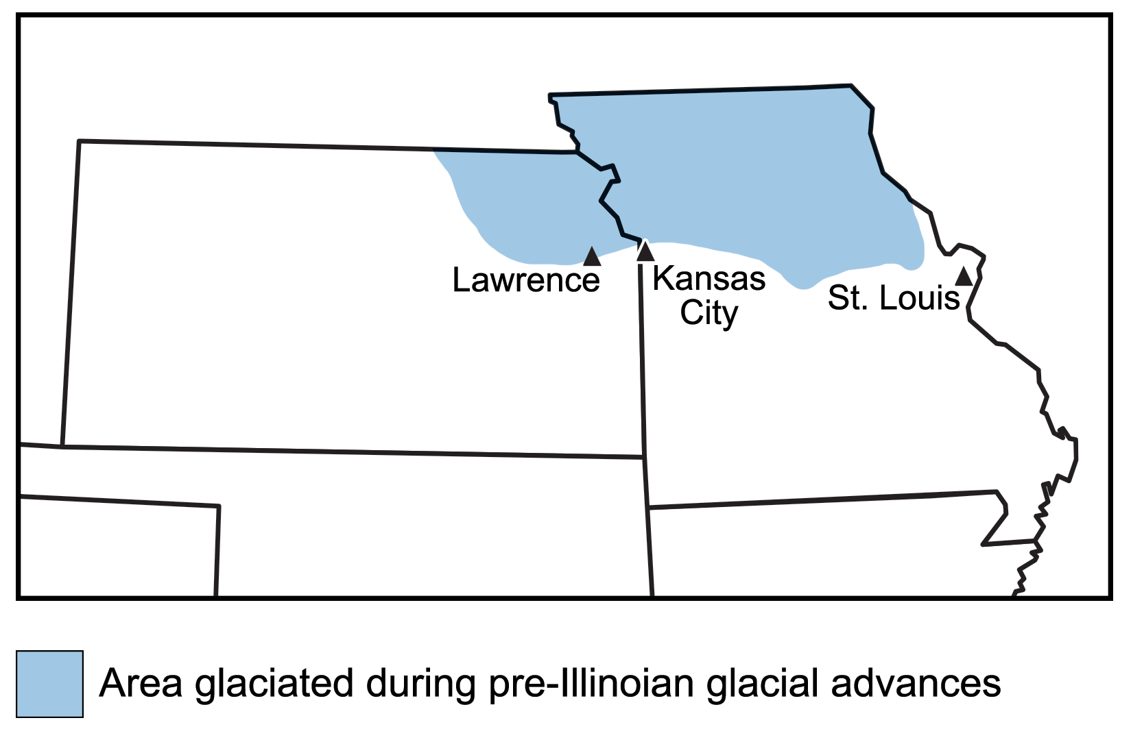
The distribution of glacial debris in Kansas and Missouri, marking the southernmost extent of glacial advance into the south-central U.S. Map by Wade Greenberg-Brand, adapted from an image by the Kansas Geological Survey, originally published in The Teacher-Friendly Guide to the Earth Science of the South Central US, modified for Earth@Home.
Glacial erratics
Glacial drift, including large numbers of rocks from outcrops that occur farther north (called glacial erratics), is the primary evidence that remains of glaciers in the south-central U.S. Larger glacial landforms that probably existed have since eroded away.
Among the most distinctive glacial erratics found in the south-central U.S. are quartzite boulders known as the Sioux quartzite. The Sioux quartzite outcrops in Iowa, Minnesota, and South Dakota. Chunks of Sioux quartzite were dragged by glaciers from the area of Sioux Falls, South Dakota, and dropped in glaciated areas of the south-central U.S. Perhaps because quartzite is so resistant to erosion, boulder fields of this rock can be especially prominent.
Sioux quartzite in Blue Mounds State Park, Minnesota, one of the states where it outcrops. Photo by Awickert/Andrew Wickert (Wikimedia Commons, Creative Commons Attribution-ShareAlike 3.0 Unported license, image cropped and resized).
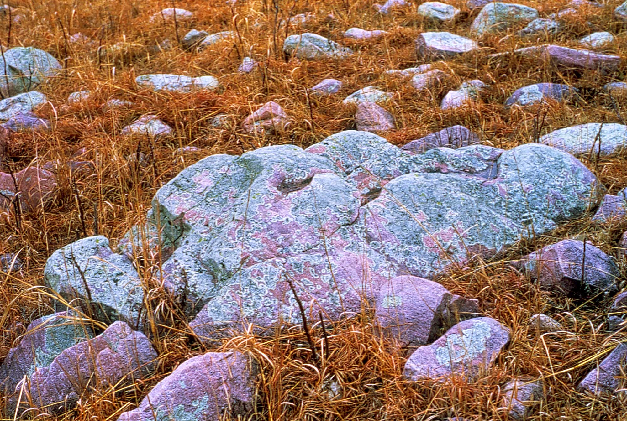
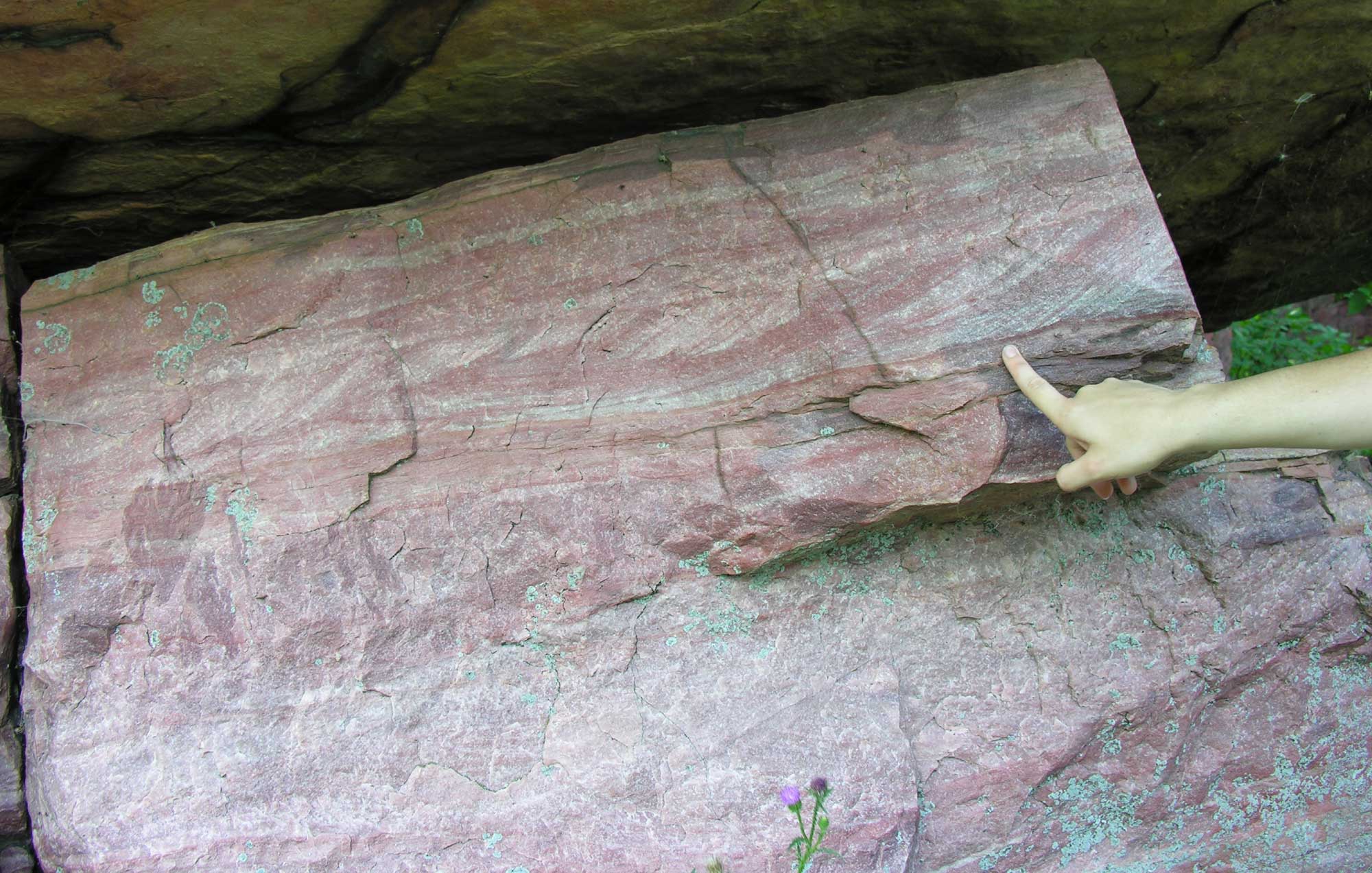
Sioux quartzite erratic boulders (boulders transported and dropped by glaciers), Wabaunsee County, Kansas. Photo by John Charlton, Kansas Geological Survey/KGS (used for non-commercial educational purposes following KGS terms of use).
The Loess Hills
The Loess Hills of extreme western Iowa, extending into northwesternmost Missouri, are named after a glacial deposit formed of windblown rock flour: loess. This type of glacial feature is found in significant quantities in only a few places on Earth. These hills form narrow, 320-kilometer (200-mile) long, north-south bands immediately east of the Missouri and Mississippi River floodplains, with thinner deposits across Kansas and central Missouri.
They loess hills were formed during several glacial/interglacial cycles when glaciers ground down the bedrock. Later, as the ice retreated, meltwater deposited the fine sediments in expansive mudflats. When the mudflats dried, strong westerly winds blew the sand into great dunes, and the finest material (silt and clay) was carried even farther in massive dust clouds. The dunes were eventually stabilized by vegetation and matured into hills, but their loose material is still easily eroded and carved. Slumping, mudslides, and undercutting caused by wind and water have produced steep slopes and a landscape of narrow ridges.
Much of the soil throughout the eastern south-central states is composed, in part, of sediment blown from huge mudflats on the banks of the ancient Missouri River, which was a major channel for floods of glacial meltwater. In and around the south-central U.S., loess deposits occur along the bluffs of the Missouri and Mississippi rivers, where they may form hills several hundred meters high. Often, exposed loess will form steep faces of fine silt. The loess can become the base of rich soils and is part of the basis for the “corn belt,” an intensively agricultural area spanning much of the Midwest and extending into the Dakotas, Nebraska, Kansas, and Missouri.
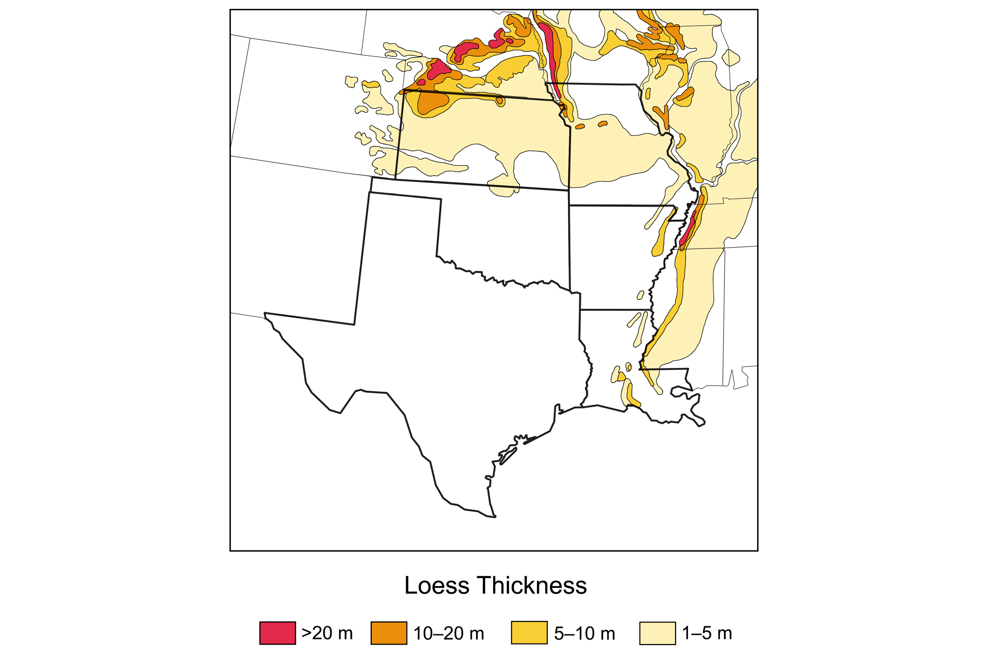
Thickness of loess deposits in the south-central U.S. Map by Wade Greenberg-Brand, adapted from an image by the Kansas Geological Survey, originally published in The Teacher-Friendly Guide to the Earth Science of the South Central US, modified for Earth@Home.
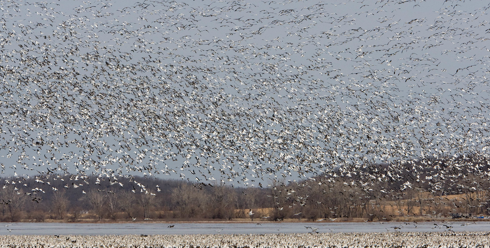
Bluffs and snow geese at Loess Bluffs National Wildlife Refuge, northwestern Missouri. The refuge is on a section of the Missouri River within the Loess Hills. Photo by Brent Fulton (flickr, Creative Commons Attribution-NonCommercial-NoDerivs 2.0 Generic license).
The coastline and glaciers
It may seem surprising that the very southernmost part of the south-central U.S., along the coastline, would be among the areas most influenced by glaciers. The reason is not related to the action of the flowing glaciers themselves, but rather the amount of water stored in glaciers globally. During glacial advances, so much water—ultimately evaporated from the surface of the ocean—is trapped in glaciers that sea level can drop by over 100 meters (330 feet). Thus, as recently as 20,000 years ago, what are now bays and river mouths along the coast of Texas and Louisiana were dry land many kilometers from the shore, as was much of the continental shelf that rims the coastline.
During each interglacial period, as sea level rose, the nature of the coastline was influenced by the erosion that had taken place in the previous glacial period, particularly in river valleys. For example, the Mississippi River cut more deeply into the land and transported more sediment during intervals of lower sea level, and, conversely, slightly higher floodplains from previous interglacial periods can be observed along the edge of the existing Holocene floodplain.
The Missouri and Mississippi rivers were conduits for some of the melting of the continental ice sheets; this meltwater contained glacially eroded sediments that contributed greatly to the Mississippi’s broad floodplains and delta. As sea level rose to near current levels, it took time for sediments to accumulate just offshore and for the system of barrier islands, lagoons, bays, and estuaries that we know today to develop. The evolution of the coastline and associated changes over the past ten thousand years influenced the history of ecosystems and human settlement of the area.
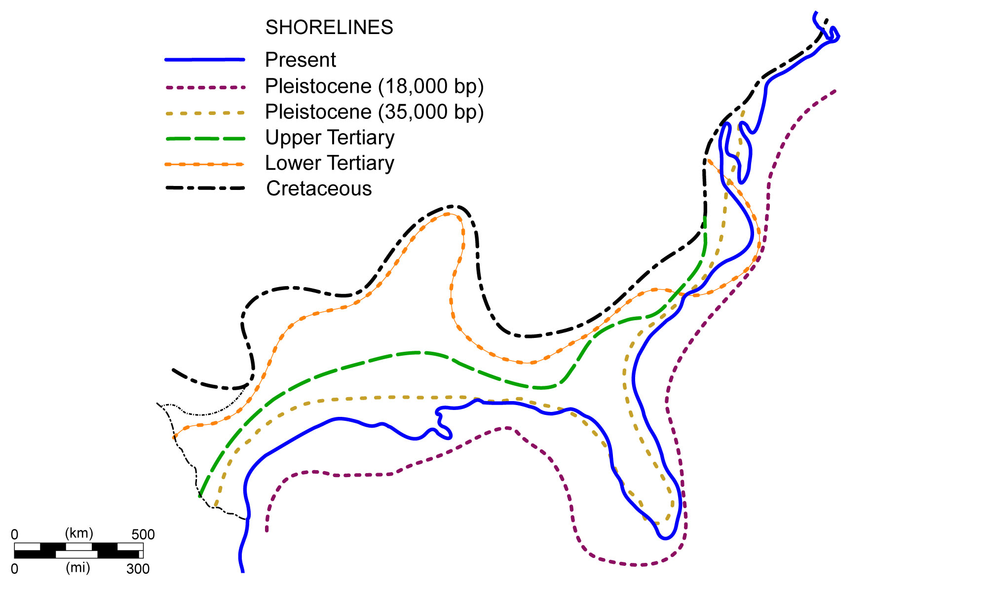
Shoreline positions along the Coastal Plain during the past 70 million years. Image modified from original by NOAA (Wikimedia Commons; public domain).
Resources
Resources from the Paleontological Research Institution
Earth@Home: Here on Earth: Introduction to Glaciers: https://earthathome.org/hoe/glaciers/