

Spotlight: Overview of the rocks of the Basin and Range region in western Texas.
Topics covered on this page: Overview; Precambrian; Paleozoic; Mesozoic; Cenozoic; Resources.
Credits: Most of the text of this page is derived from "Rocks of the South Central US" by Richard A. Kissel, Alex F. Wall, and Andrielle N. Swaby, chapter 2 in The Teacher-Friendly Guide to the Earth Science of the South Central US, edited by Mark D. Lucas, Robert M. Ross, and Andrielle N. Swaby (published in 2015 by the Paleontological Research Institution). The book was adapted for the web by Elizabeth J. Hermsen and Jonathan R. Hendricks in 2021–2022. Changes include formatting and revisions to the text and images. Credits for individual images are given in figure captions.
Updates: Page last updated January 24, 2022.
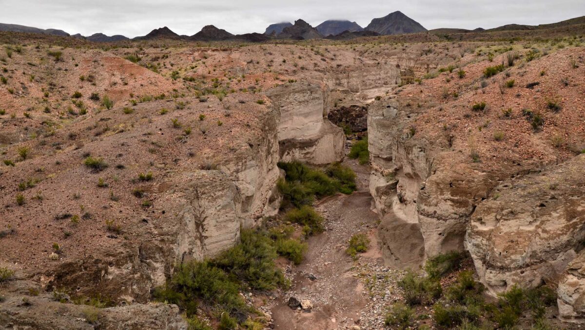
Image above: Image above: Tuff Canyon at Big Bend National Park, Texas. Photograph by Tony Fernandez (Flickr; Creative Commons Attribution-NonCommercial 2.0 Generic license).
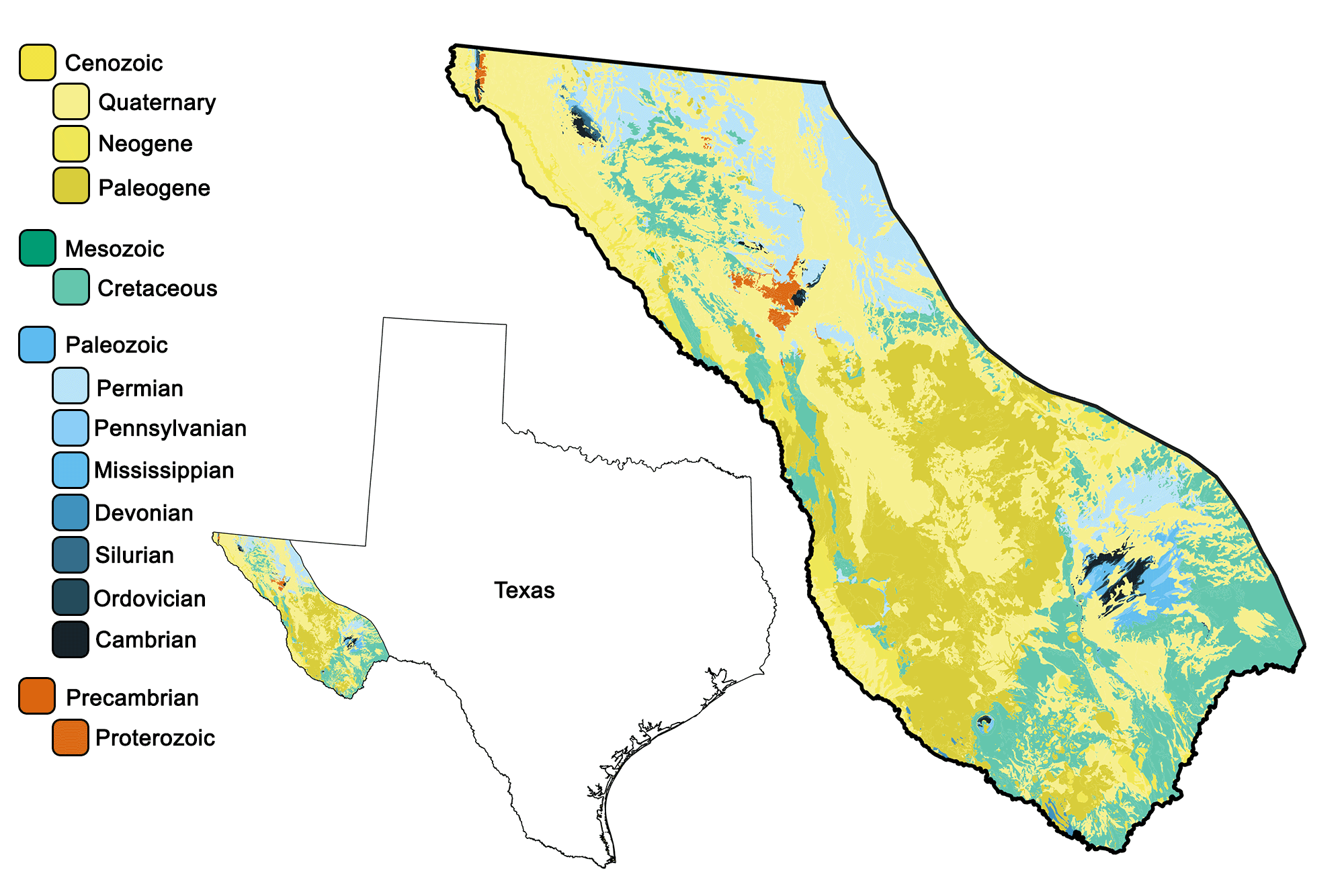
Geologic map of the Basin and Range region of the South-Central United States showing maximum ages of mappable units. Image by Jonathan R. Hendricks for the Earth@Home project developed using QGIS and USGS data (public domain) from Fenneman and Johnson (1946) and Horton et al. (2017).
Overview
The Basin and Range is a huge physiographic region that extends from southeastern Oregon to west central Mexico. Only a tiny portion of it is found within the South-Central United States, in far western Texas. Even so, the Basin and Range may be the South Central’s most geologically complex region—in this tiny area of Texas, rocks can be found from nearly all periods of the Phanerozoic.
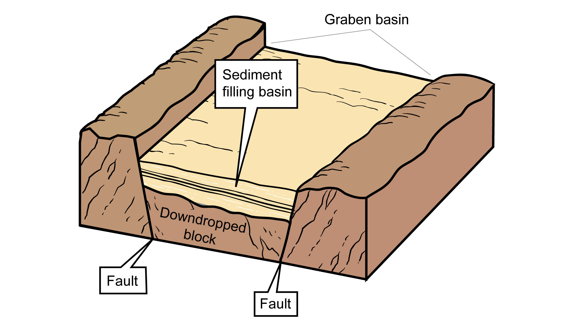
This is largely because the region’s most recent geologic activity involved crustal extension that has exposed many deeper, older layers. During the Paleogene, magma upwelling from the mantle weakened the lithosphere, lowering its density. This stimulated uplift, stretching the bedrock in an east-west direction. The crust along the Basin and Range stretched, thinned, and faulted into some 400 separate mountain blocks. Movement along the faults led to a series of elongated peaks and down-dropped valleys, also called horst and graben landscapes. In a manner similar to books toppling when removing a bookend from a shelf, the blocks slid against each other as they filled the increased space.
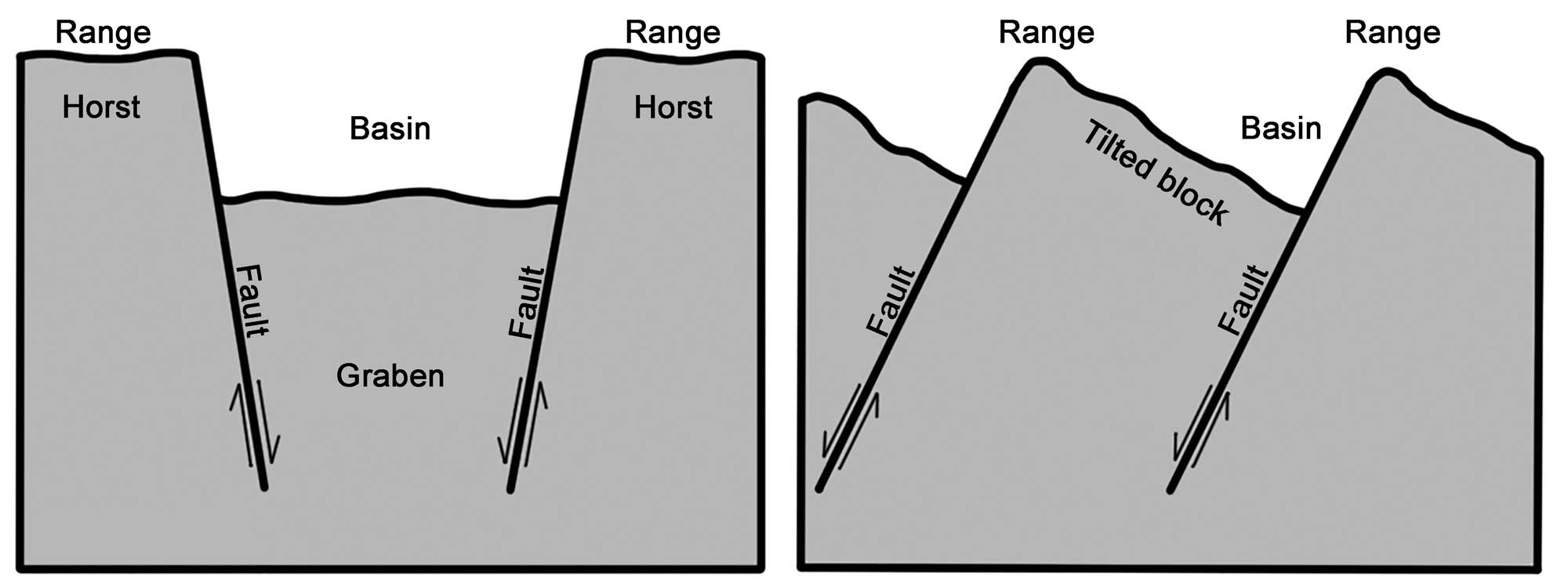
Alternating basins and ranges were formed during the past 17 million years by gradual movement along faults. Arrows indicate the relative movement of rocks on either side of a fault. Image modified from original by Wade Greenberg-Brand, in turn adapted from an image by the USGS (public domain).
Precambrian
The oldest rocks in the Basin and Range region, and in all of Texas, are part of the Franklin Mountains near El Paso.
The faulted rocks of Sneeds Cory, a popular rock-climbing route in the Franklin Mountains, are an excellent example of Precambrian layers that were tilted and fractured during the formation of the Basin and Range. "Sneeds Cory in 8K" by 8K Klips (YouTube).
The coast of the ancient continent is represented by marble, the metamorphic product of limestone deposited 1.3 billion years ago. Multiple lava flows and magmatic intrusions break up overlying quartzite that makes up the bulk of the area’s Precambrian rock.
Rocks that are 1.1 billion years of age are also found farther west near Van Horn, where Precambrian rock formed in somewhat deeper water. This rock has been more dramatically altered, with limestones and shales transformed into phyllite, schist, and quartzite. Just to the northwest, the Sierra Diablo Mountains contain billion-year-old, iron-rich red beds, along with a 950-million-year-old volcanic deposit.
Paleozoic
Paleozoic rocks are well-represented in the Basin and Range. The Marathon Uplift near Marathon, Texas was created by the same forces that formed the Llano Uplift in the Great Plains, and it exposes a long sequence of sedimentary rocks. These begin in the Cambrian with a relatively thin package of shales, limestones, and sandstones that extend through to the Mississippian—only 950 meters (3100 feet) of rock were deposited over a period of 170 million years. However, sedimentation rates dramatically increased by the start of the Pennsylvanian, depositing more than 4200 meters (13,800 feet) of material by the beginning of the Permian, 60 million years later.
The Permian rocks of the Basin and Range are primarily marine, formed in the foreland basins created by the Ouachita Orogeny to the east. The northeastern part of the Marathon Uplift, and the series of mountain ranges between El Paso and Pecos, include many Permian rocks—for example, the Guadalupe Mountains contain the massive limestone remains of a Permian barrier reef.
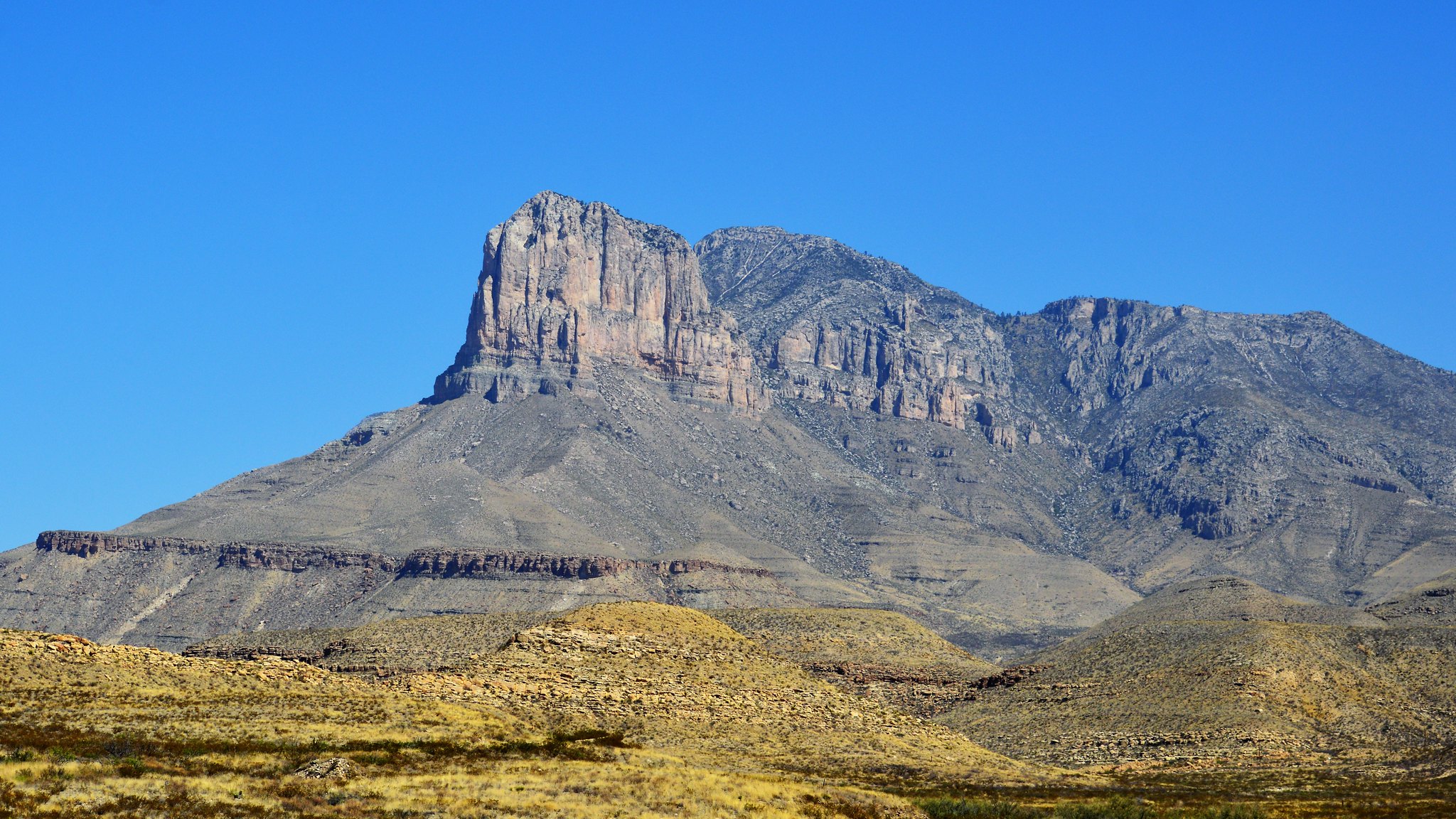
El Capitan, the southern end of the Guadalupe escarpment, is an ancient limestone reef. It rises to an elevation of 2458 meters (8064 feet). Photograph by Diann Bayes (Flickr; Creative Commons Attribution-NonCommercial-NoDerivs 2.0 Generic license).
Mesozoic
As the Permian came to a close, a retreating sea left salt deposits west of Pine Springs, and the region became terrestrial. During the Cretaceous, much of the Basin and Range was again flooded by the Western Interior Seaway. The remnants of limestones deposited at the seaway’s bottom form the capstones of many of western Texas’ characteristic mesas.
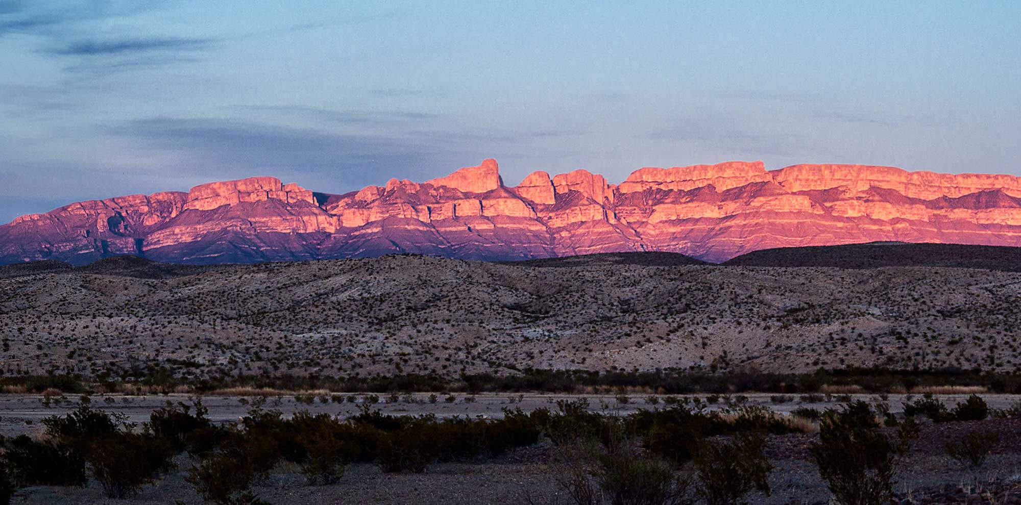
Many mesas and cliffs in Big Bend National Park, for example here at the Sierra del Carmen, are capped by Cretaceous limestones. Photograph by Gary Nored (Flickr; Creative Commons Attribution-NonCommercial 2.0 Generic license; image cropped and resized).
Cenozoic
The Paleogene saw magma well up from the mantle from about 50 to 45 million years ago, intruding into the existent rock layers. By about 35 million years ago, upwelling intensified and the mantle began to uplift the crust, effectively tearing it and causing it to fracture and fault at the surface. This process formed the Basin and Range’s current rugged landscape, created numerous igneous intrusions, and it also fed the region’s volcanoes. Basalt flows and gabbro sills added to earlier andesite plutons to create thousands of feet of igneous rock. (A pluton is a large body of igneous rock that formed under the Earth’s surface through the slow crystallization of magma. The term comes from the name of Pluto, Roman god of the underworld.)
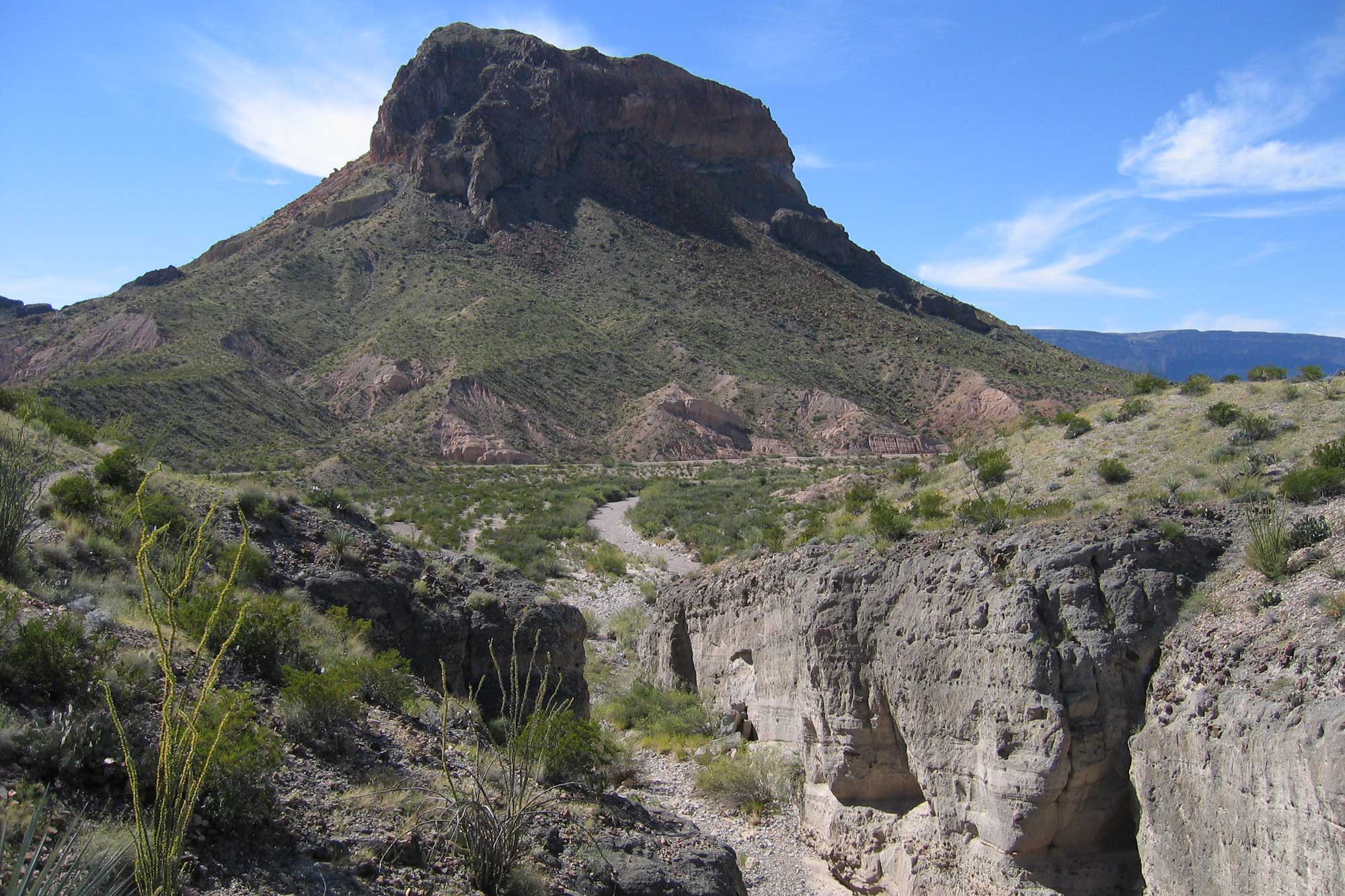
Igneous landscapes of Big Bend National Park. Tuff Canyon is composed of welded pyroclastic flows that occurred during the Paleogene. Cerro Castellan, in the background, is made up of a dense lava low underlain by tuff and basalt. Photograph by "12-Foot Hedgehog Productions" (Flickr; Creative Commons Attribution-NonCommercial-ShareAlike 2.0 Generic license; image cropped and resized).
While limited extensional forces continued to act on the Basin and Range up until 10 million years ago, the dominant activity in the region since the beginning of the Neogene has been erosion. The region’s valleys are being filled with sediment from the surrounding mountains and mesas, creating thick deposits in northwest-southeast trending bands.
Basin fill in the Basin and Range. Image modified from original by Jim Houghton.
Resources
Resources from the Paleontological Research Institution
Digital Encyclopedia of Earth Science: Minerals: https://earthathome.org/de/minerals/
Earth@Home: Here on Earth: Rocks: https://earthathome.org/hoe/rocks/
Earth@Home Virtual Collection: Rocks: https://earthathome.org/vc/rocks/ (Virtual rock collection featuring 3D models of rock specimens sorted by type.)