

Spotlight: Overview of the rocks of the Great Plains region of the South-Central United States, including Texas, Oklahoma, and Kansas.
Topics covered on this page: Overview; Precambrian; Paleozoic; Mesozoic; Cenozoic; Resources.
Credits: Most of the text of this page is derived from "Rocks of the South Central US" by Richard A. Kissel, Alex F. Wall, and Andrielle N. Swaby, chapter 2 in The Teacher-Friendly Guide to the Earth Science of the South Central US, edited by Mark D. Lucas, Robert M. Ross, and Andrielle N. Swaby (published in 2015 by the Paleontological Research Institution). The book was adapted for the web by Elizabeth J. Hermsen and Jonathan R. Hendricks in 2021–2022. Changes include formatting and revisions to the text and images. Credits for individual images are given in figure captions.
Updates: Page last updated January 24, 2022.
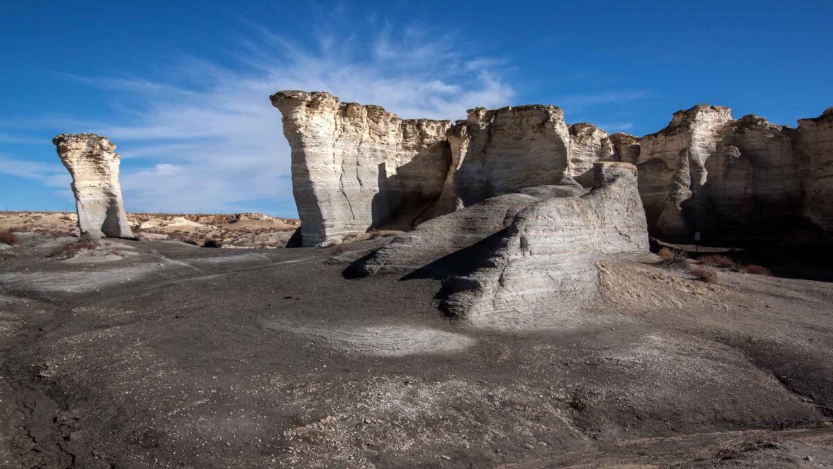
Image above: Image above: Outcroppings of the Cretaceous Niobrara Formation at Monument Rocks in western Kansas. Photograph by Vincent Parsons (Flickr; Creative Commons Attribution-NonCommercial 2.0 Generic license; image cropped and resized).
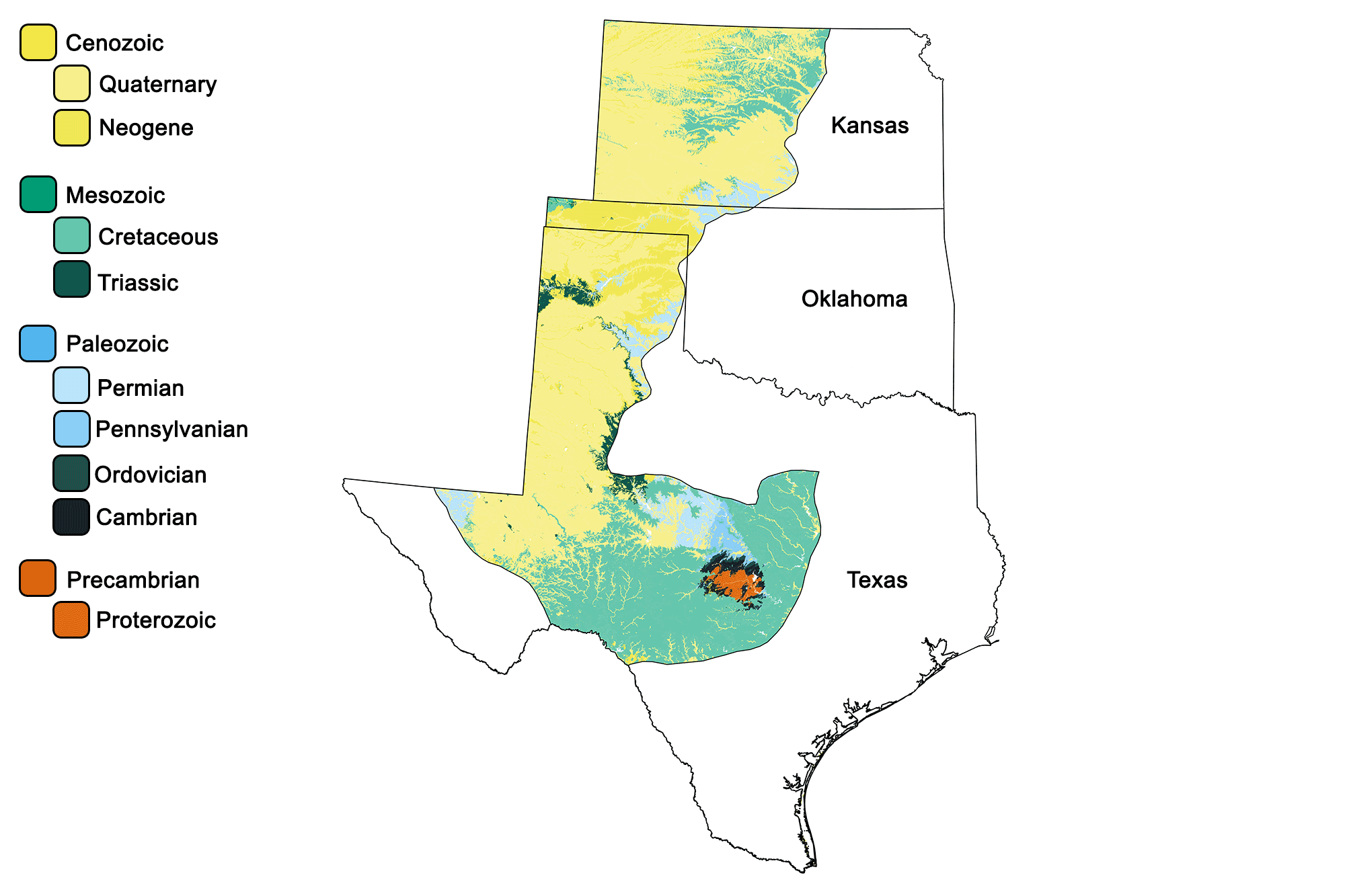
Geologic map of the Great Plains region of the South-Central United States showing maximum ages of mappable units. Image by Jonathan R. Hendricks for the Earth@Home project developed using QGIS and USGS data (public domain) from Fenneman and Johnson (1946) and Horton et al. (2017).
Overview
The Great Plains region is defined by the Rocky Mountains to the west and the Central Lowland to the east, with the Balcones Fault in Texas creating the divide between the Great Plains and the Coastal Plain in the southeast. The region’s geologic history is chiefly one of sedimentary deposition driven first by marine environments and, more recently, by terrestrial deposition from the erosion of the Rocky Mountains to the west.
Precambrian
The oldest rocks in the Great Plains can be found in the Llano Uplift of central Texas. This area contains an uplifted batholith of distinctive pink Precambrian granite (called the Town Mountain granite), and is famous for its large formations such as Enchanted Rock, the largest isolated outcrop of pink granite in the United States.
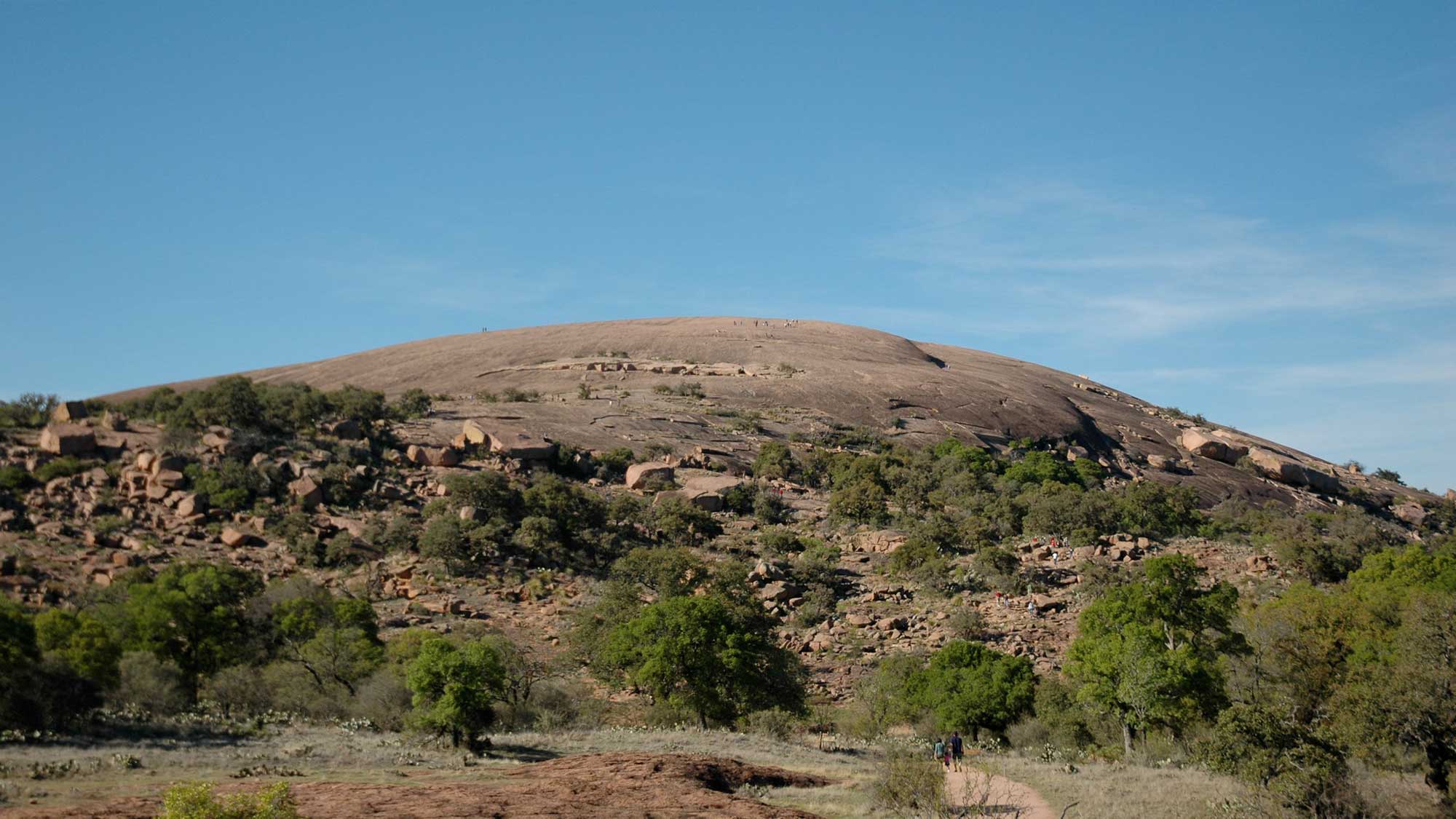
Enchanted Rock stretches across 260 hectares (640 acres) and rises approximately 130 meters (425 feet) above the surrounding landscape. Photograph by Carlos Lowry (Flickr; Creative Commons Attribution-NonCommercial 2.0 Generic license).
This granite formed 1.1 billion years ago during the Grenville Orogeny, when it intruded into the surrounding Precambrian Packsaddle schist and Valley Springs gneiss. The Llano Uplift also includes the only known deposits of llanite (named for Llano County), a type of rhyolite containing large phenocrysts of feldspar and blue quartz.
Interactive 3D model of a sample of llanite. Original caption: "This sample might be called a melarhyolite because it’s quite dark. However, even though the groundmass is dark, it still contains fairly large concentrations of pink potassium feldspar crystals as well as relatively uncommon, and quite beautiful blue quartz. This rock is called a llanite, and it was collected from the famous dike of llanite that outcrops near Llano, Texas." Model by Weber State University, Department of Earth & Environmental Sciences (Sketchfab).
The Town Mountain granite, exposed through the erosion of surrounding rock, is heavily exfoliated. Although granite is under tremendous pressure when it forms deep underground, it is at equilibrium with the surrounding rock because the pressure on it is equal in every direction. However, once it is exposed at the surface, the absence of significant downward pressure allows it to expand upward. This expansion causes joints, or cracks, to form parallel to the surface, producing slabs that resemble the curved layers of an onion.
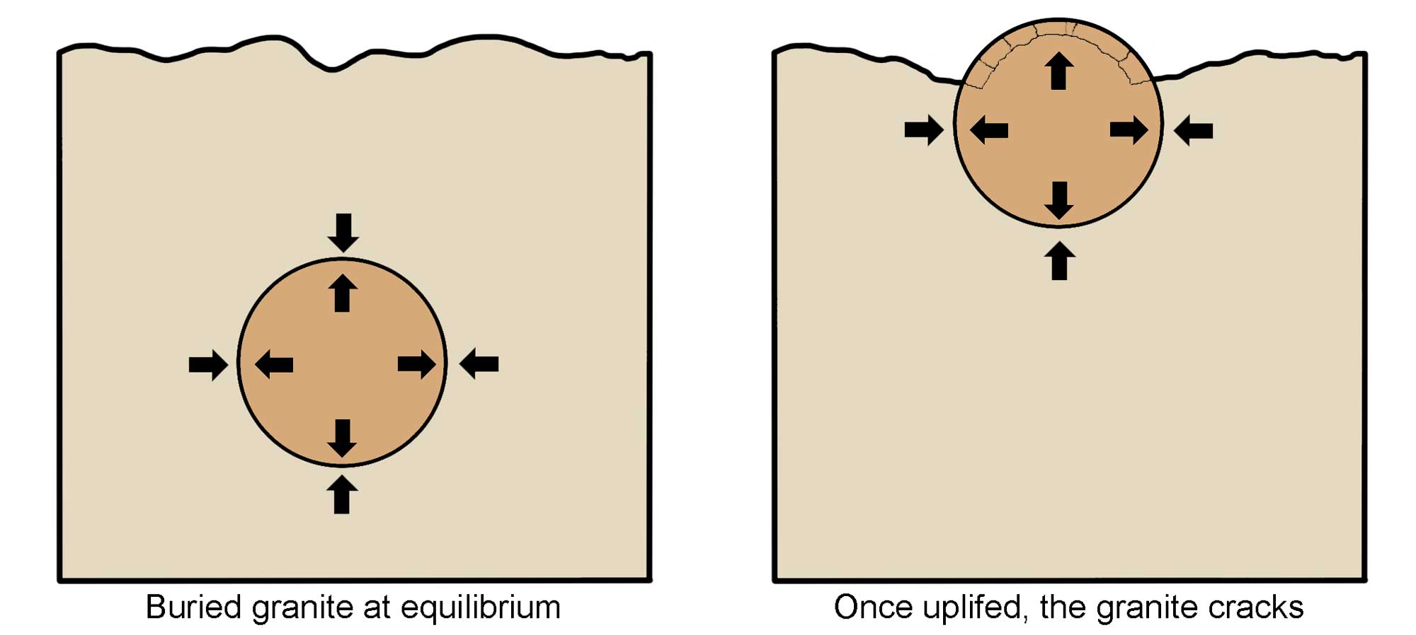
Diagram showing how the process of exfoliation works as a result of uplift and release of pressure. Image modified from original by Wendy Van Norden for the Earth@Home project.
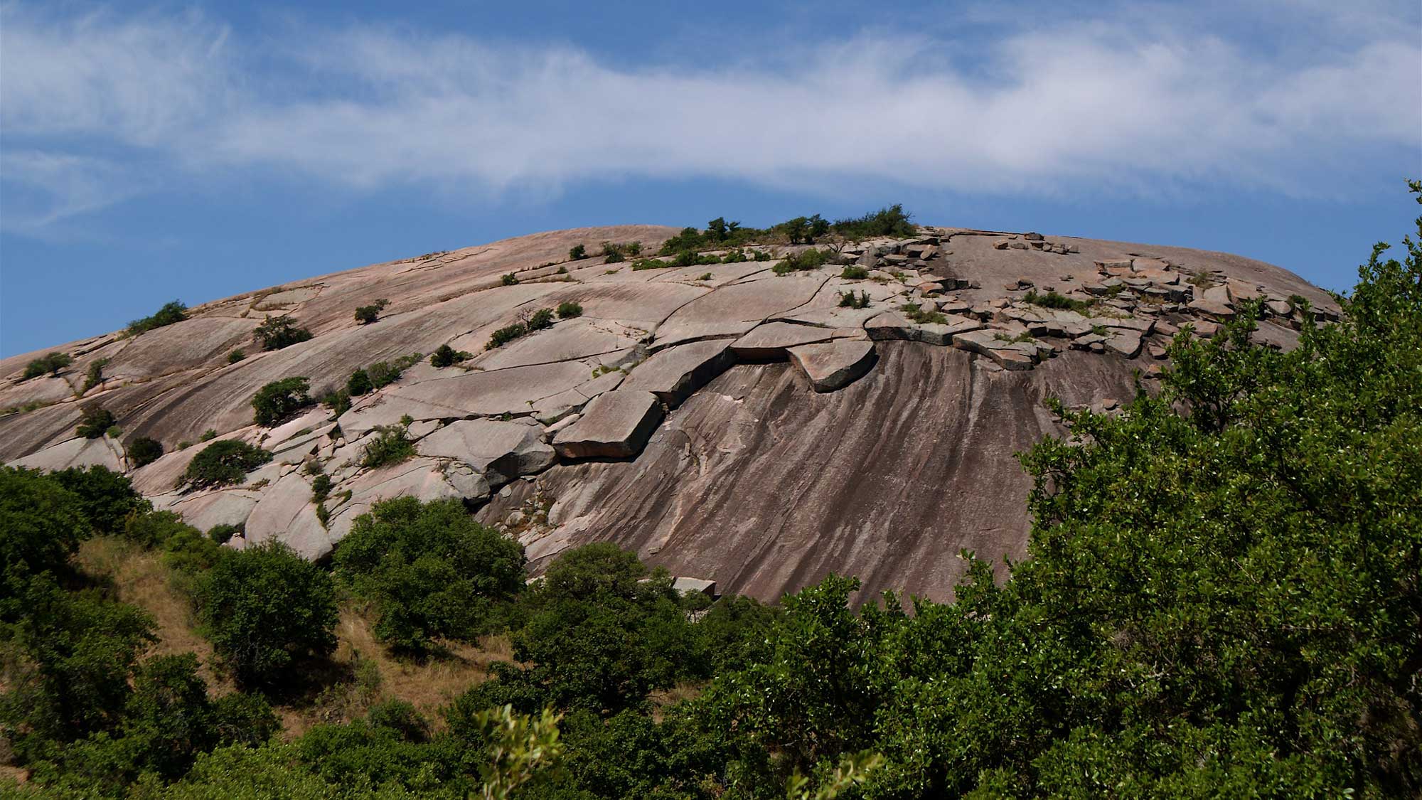
Exfoliation joints on a granite dome in Enchanted Rock State Natural Area. Photograph by J.B. Hill (Flickr; Creative Commons Attribution 2.0 generic license; image cropped and resized).
Paleozoic
Throughout much of the Paleozoic era until the early stages of the Carboniferous, the Great Plains region was submerged in a shallow sea. Shales, limestones, dolostones, and sandstones dominate the Paleozoic strata of Kansas, Oklahoma, and Texas, although they are now buried by younger Cenozoic sediments.
Mesozoic
In the Jurassic, the sea level regressed and the region became exposed. During this time, sandstones and shales were deposited in Texas by a large river system.
In the Cretaceous, the Great Plains were covered again as a shallow sea extended northward from the Gulf of Mexico across North America, and 1500- to 3000-meter-thick (5000- to 10,000-foot-thick) deposits of shale and limestone were formed. Cretaceous sediments are exposed within the Smoky Hills of Kansas—an area known for its sandstone, limestone, and chalk.
The Dakota Sandstone is the oldest Cretaceous rock in the Great Plains, having formed around 95 million years ago. It is exposed at Mushroom Rock State Park in north-central Kansas, where hoodoos capped by sandstone concretions stand out from the landscape. A hoodoo forms when weathering erodes a softer material out from underneath a mass of harder capstone, leading to “mushroom” formations.
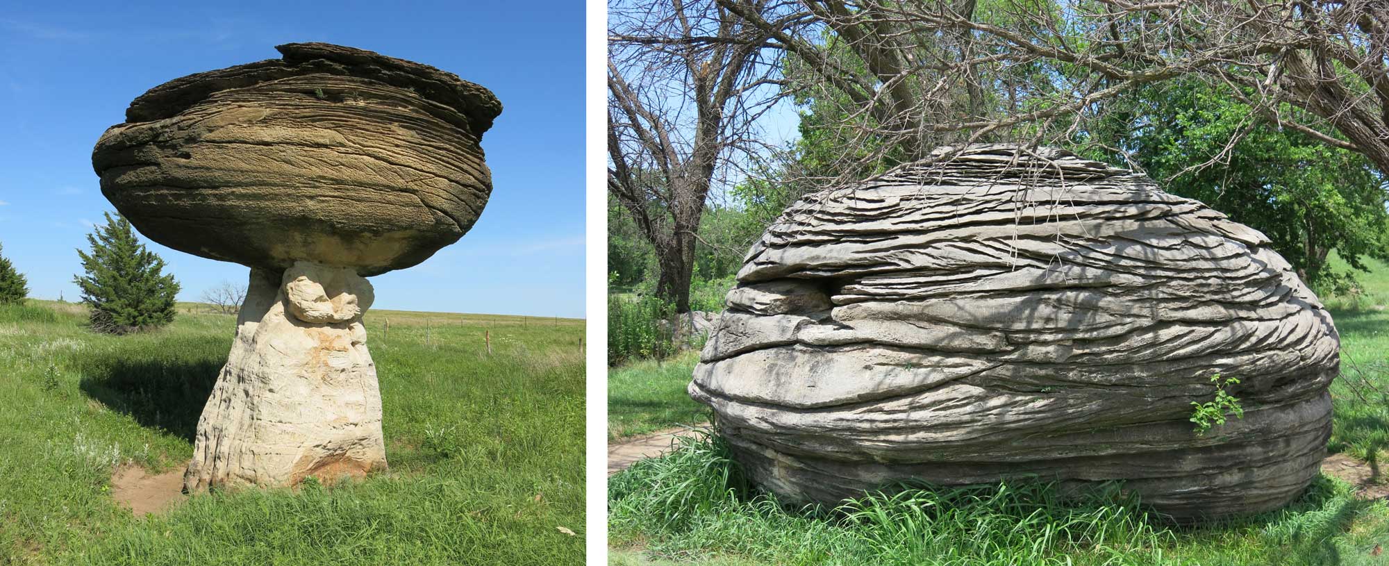
Left: This hoodoo in Mushroom Rock State Park is made up of a concretion of erosion-resistant, Cretaceous-aged Dakota Sandstone atop a pillar of softer sedimentary rock. Right: The soft pillar that once supported this hoodoo has been eroded away. Photographs contributed by Anton Oleinik for the Earth@Home project.
The Niobrara Chalk, laid down around 85 million years ago, formed from the carbonate shells of tiny marine microorganisms and is extremely rich in fossils. Found within the chalk is an extensive record of fossil vertebrates—from fish and birds to flying and swimming reptiles—that provides an incredible glimpse into the Western Interior Seaway of the Cretaceous period. The Niobrara Chalk is also known for its pillar- and spire-shaped outcrops.
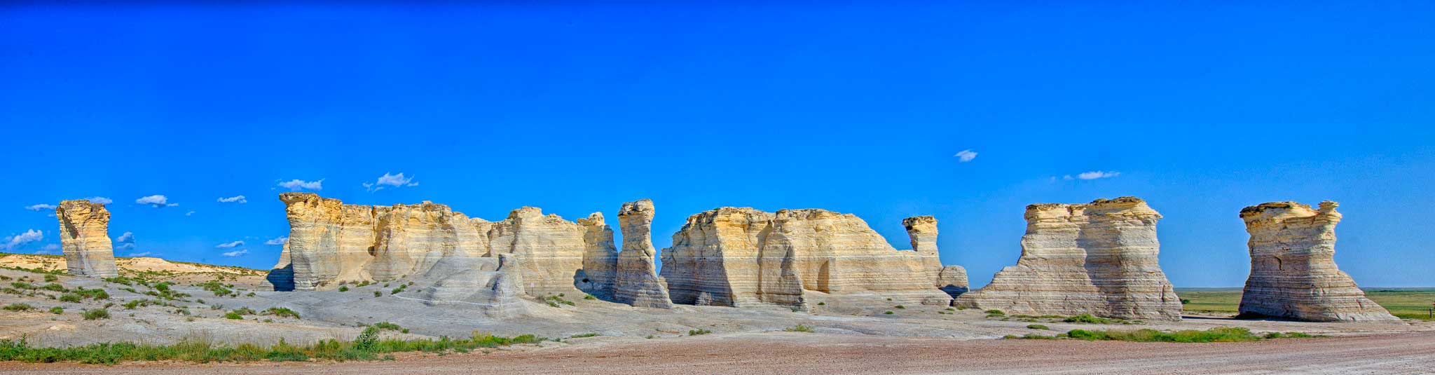
The Monument Rocks, an outcropping of the Niobrara Chalk in western Kansas. Photograph by Patrick Emerson (Flickr; Creative Commons Attribution-NoDerivs 2.0 Generic license).
Cenozoic
With the rise of the Rocky Mountains to the west, erosion and Cenozoic-era volcanism produced sediment that was transported and deposited throughout the Great Plains. Gravel, sand, and mud dominate the region’s surface, with progressively younger sediment located farther from the mountain chain. This mass of eroded material eventually filled stream valleys and covered hills, creating a massive, gently sloping plain that was in place by five million years ago. The western third of Kansas and the panhandle of Oklahoma are capped by the Ogallala Formation, a unit of unconsolidated sands, gravels, and clays that eroded from the Rockies. The Ogalalla Formation is extremely porous, and as a result it acts as an important aquifer for much of the Great Plains.
Resources
Resources from the Paleontological Research Institution
Digital Encyclopedia of Earth Science: Minerals: https://earthathome.org/de/minerals/
Earth@Home: Here on Earth: Rocks: https://earthathome.org/hoe/rocks/
Earth@Home Virtual Collection: Rocks: https://earthathome.org/vc/rocks/ (Virtual rock collection featuring 3D models of rock specimens sorted by type.)