

Page snapshot: Introduction to energy in the Inland Basin region of the southeastern United States, including fossil fuels, renewable energy, and nuclear power.
Topics covered on this page: Oil and gas; Appalachian Basin; Other oil- and gas- producing basins; Natural asphalt; Coal; Hydroelectricity; Wind energy; Nuclear power; Resources.
Credits: Most of the text of this page is derived from "Energy in the Southeastern US" by Carlyn S. Buckler, Peter L. Nester, Stephen F Greb, and Robert J. Moye, chapter 6 in The Teacher-Friendly Guide to the Earth Science of the Southeastern U.S., 2nd ed., edited by Andrielle N. Swaby, Mark D. Lucas, and Robert M. Ross (published in 2016 by the Paleontological Research Institution; currently out of print). The book was adapted for the web by Elizabeth J. Hermsen and Jonathan R. Hendricks in 2021–2022. Changes include formatting and revisions to the text and images. Credits for individual images are given in figure captions.
Updates: Page last updated October 12, 2022.
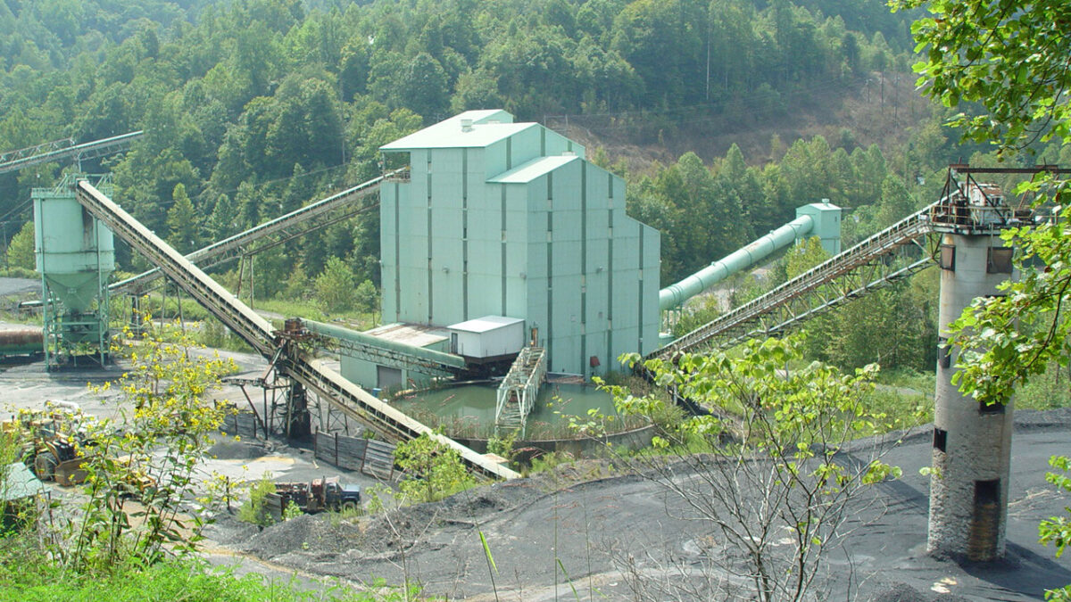
Image above: A disused coal washer, Clay County, Kentucky. Photo by Jfacew (Wikimedia Commons, Creative Commons Attribution-ShareAlike 3.0 Unported license, image cropped).
Overview
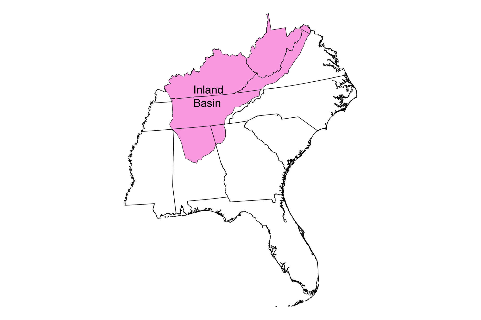
The Inland Basin is a renowned source of fossil fuels: its ancient environments and geological history were ideal for the formation and preservation of widespread deposits of coal, oil, and natural gas. Appalachian Basin coal, along with oil and natural gas, fueled the industrial growth of the Eastern Seaboard and westward expansion. The coal-bearing region of the Appalachian Basin extends 1300 kilometers (800 miles) from northern Pennsylvania to Alabama, and covers an area of 186,000 square kilometers (72,000 square miles) in parts of nine states. The Inland Basin also has modest hydroelectric power generated by a wet climate and topographic relief. Solar energy and biofuel production are growing industries, but remain small.
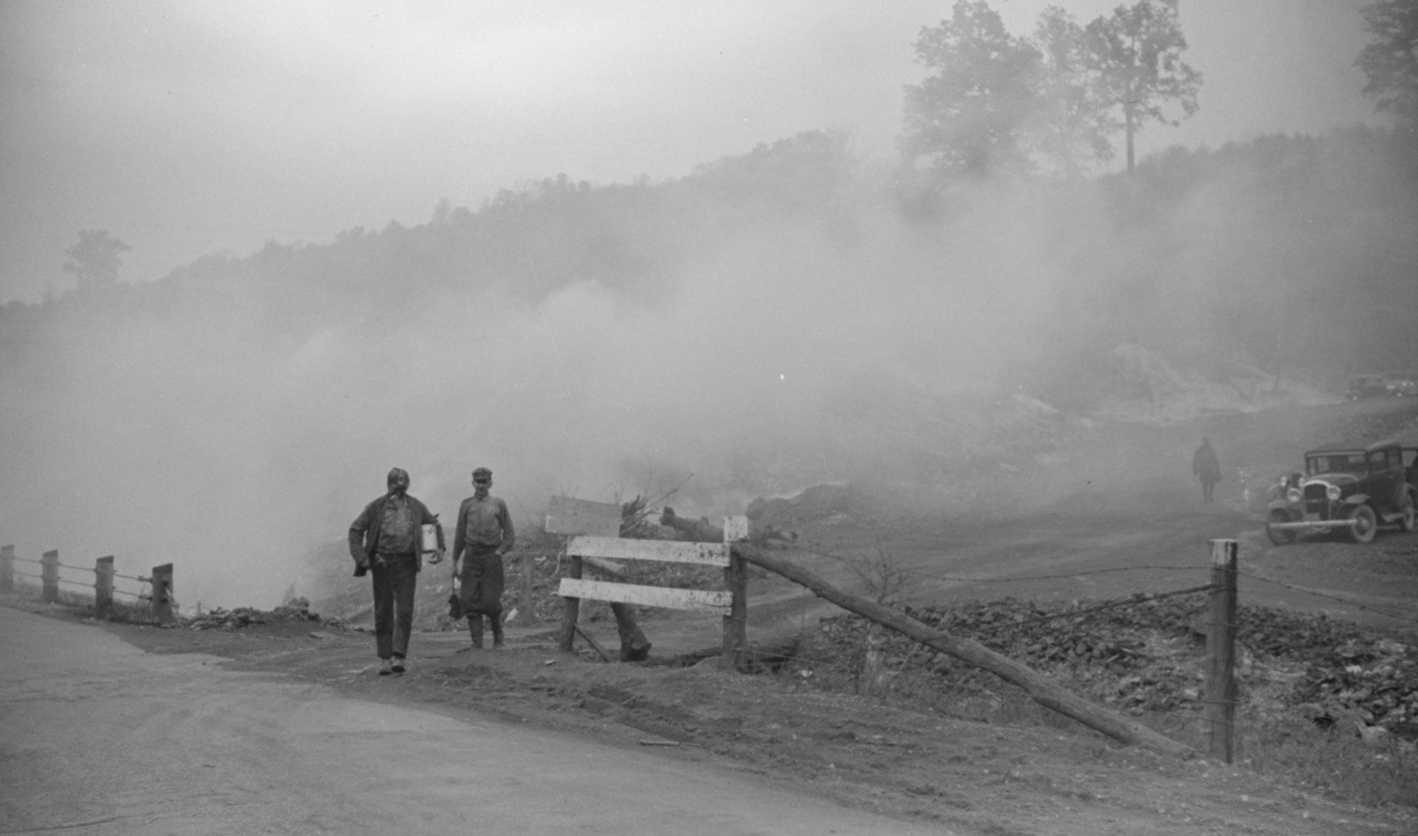
Title: "Coal miners coming from work. Slag heaps burning nearby. Maidsville, West Virginia." Photo by Marion Post Wolcott, 1938 (National Farm Security Administration-Office of War Information Photograph Collection, Library of Congress, no known restrictions.)
Oil and gas
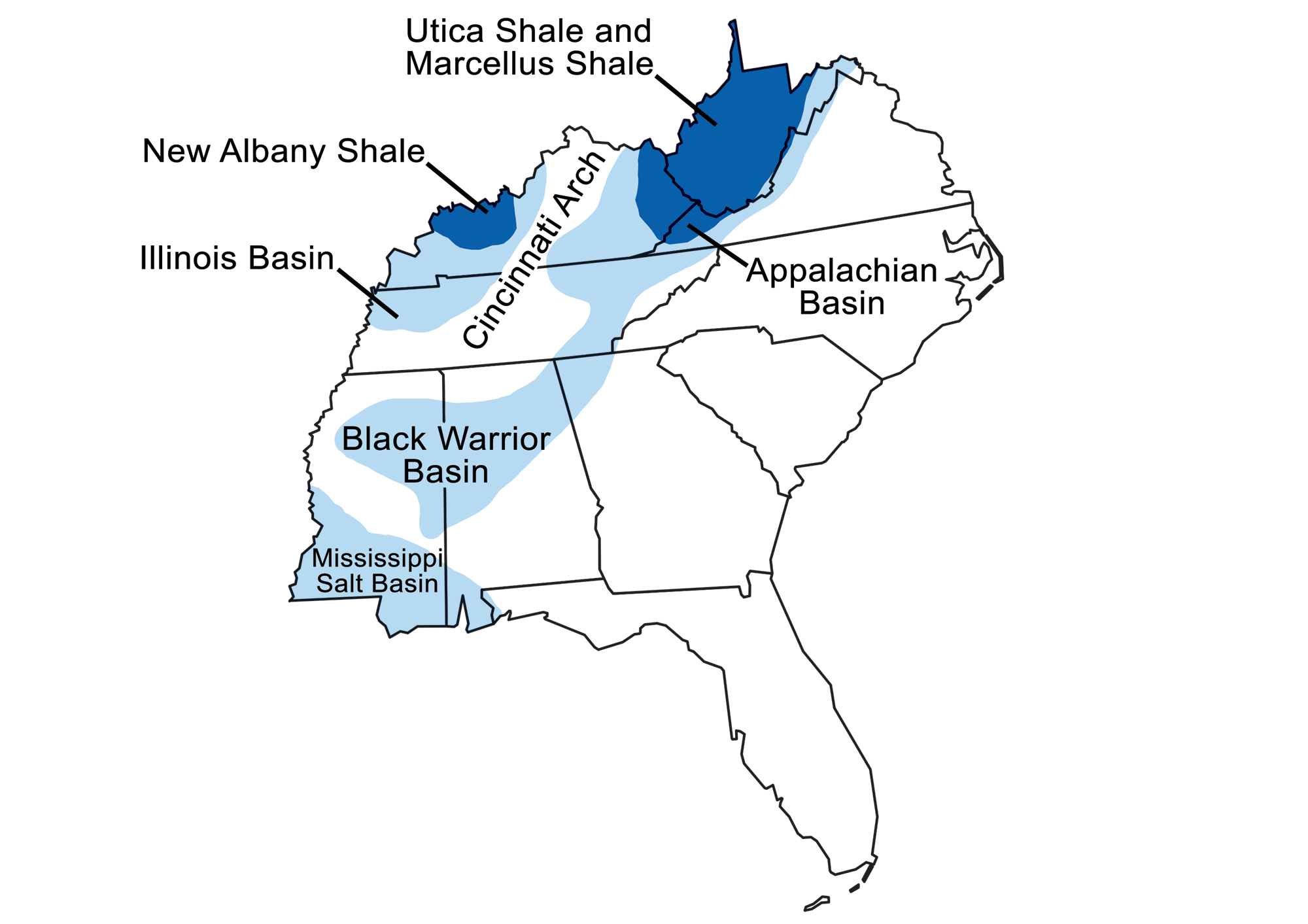
Sedimentary basins containing significant fossil fuel accumulations in the Southeastern US. Modified from original by Wade Greenberg-Brand for the Earth@Home project.
Appalachian Basin
The Appalachian Basin is a sedimentary basin formed in the Paleozoic during the Taconic and Acadian orogenies. During the formation of the ancestral Appalachian Mountains, the crust was buckled and downwarped repeatedly to form the basin, which is deepest beneath the Appalachian Plateau. The sedimentary rocks of the Appalachian Plateau are not tightly folded like the Valley and Ridge (an adjoining physiographic region). They have broad, gentle folds as well as faults, both of which trap oil and gas.
Energy resources have been extracted from rock layers of Ordovician through Pennsylvanian age. Famous rock units acting as reservoirs include the Oriskany Sandstone, which extends from New York into Virginia, and the Greenbrier Limestone (the "Big Lime") and its equivalents, which extend throughout West Virginia, eastern Kentucky and Tennessee, and parts of Alabama, Georgia, and Virginia.
Not all reservoirs are extensive. More isolated reservoirs are found in the Mississippian-aged Fort Payne Formation in eastern Tennessee. These reservoirs occur in permeable carbonate mounds (called bioherms) that were formed in shallow seas. The mounds were buried by mud, which formed a shale caprock that acts as a trap for oil that migrated into the mounds.
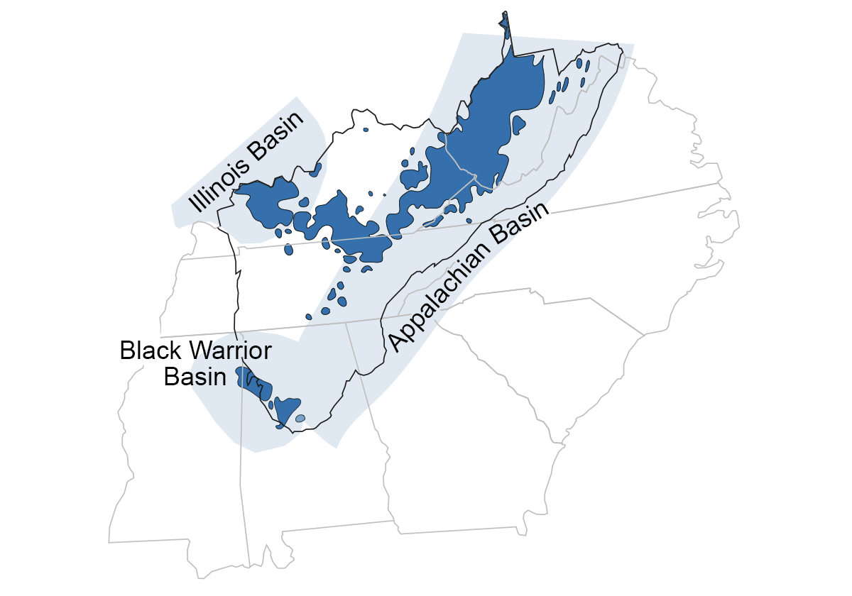
Clusters of oil and gas fields in the Inland Basin of the Southeast. Modified from the original by Jim Houghton for the Earth@Home project.
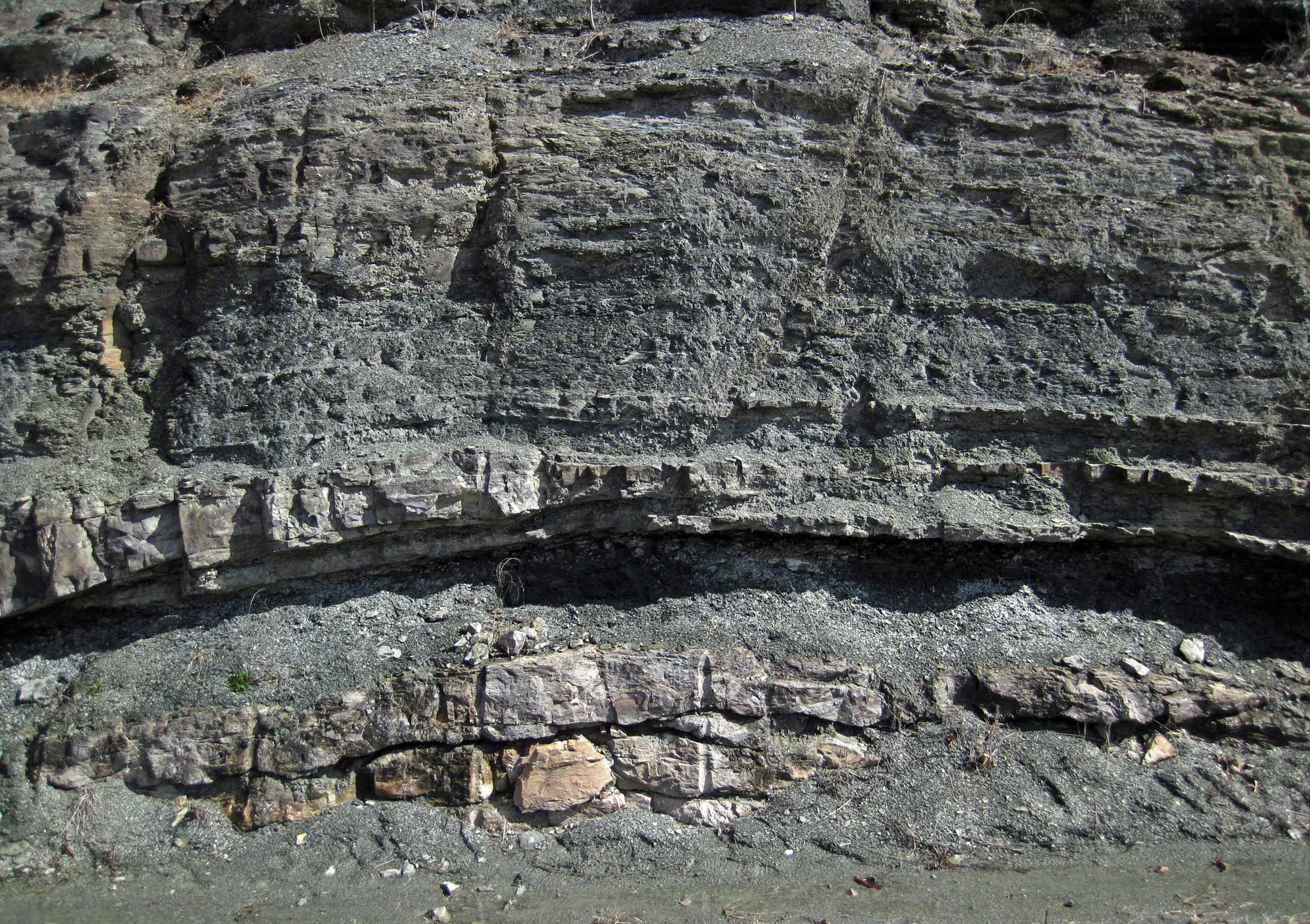
Bioherm (bottom); the layers on top of the bioherm are curved, reflecting the mounded shape of the structure. Lower Carboniferous (Mississippian) Fort Payne Formation, Kentucky. Photo by and information from James St. John (flickr, Creative Commons Attribution 2.0 Generic license, image resized).
History of oil production
The Appalachian Basin was the site of much early oil exploration. Thomas Jefferson visited springs venting natural gas on a stream called Burning Springs, a tributary of the Little Kanawha River in West Virginia, as early as 1781. He wrote an article describing the brilliant flame that could be produced by thrusting a lighted candle into the escaping gas.
In the early and mid-1800s, drillers searching for salt in the Appalachians sometimes struck oil by accident. In 1819, Martin Beatty of Abingdon, Virginia, encountered oil while drilling for salt on the South Fork of the Cumberland River in Kentucky, near the Tennessee state line. Another salt prospect well near Burkesville, Kentucky, struck pressurized oil in March 1829. Called the "Great American Oil Well," the gusher flowed into the nearby Cumberland River and the oil was carried over 64 kilometers (40 miles) downstream. The floating oil ignited and burned for three weeks, halting riverboat traffic. Overall, the well is estimated to have produced 50,000 barrels of oil, most of which was sold as lamp oil or medicine.
In 1859, the Rathbone brothers struck oil in a well drilled along Burning Springs in West Virginia; based on this discovery, they drilled another well the following year, producing 1200 barrels of oil a day. Petroleum production spread rapidly throughout the Appalachian Basin in the 1860s, reaching its peak by 1900, the culmination of the first major US oil boom.
Early oil wells, like the Rathbone brothers' well, were dug using a spring pole device. In this video, a presenter explains how this labor-intensive method of creating an oil well works. "Drilling Deeper: Spring Pole Drilling Rig," Oil Museum of Canada National Historic Site, via YouTube.
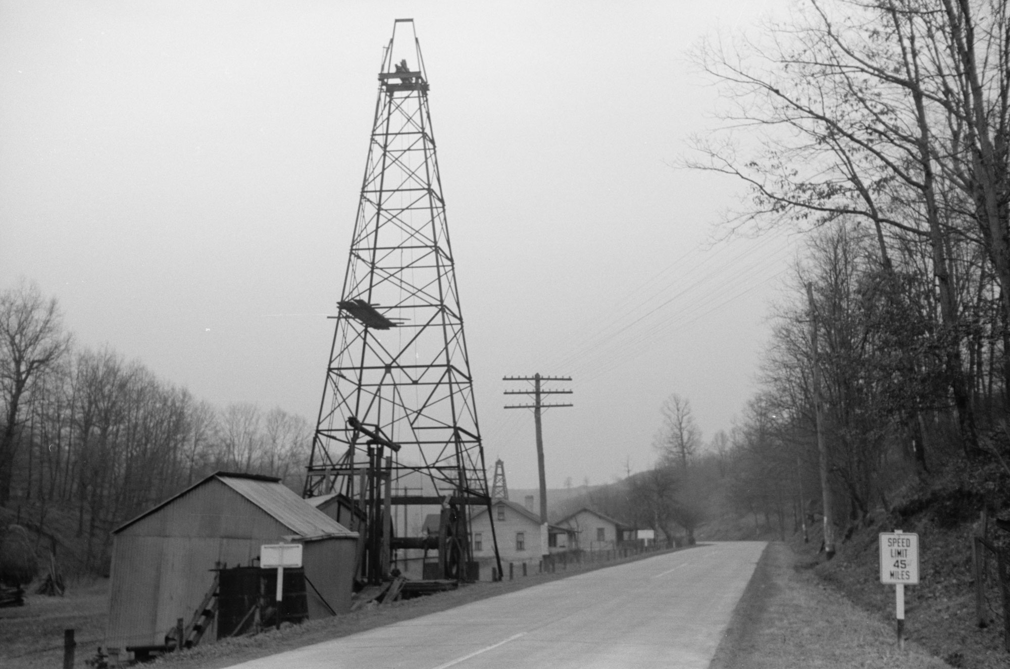
Original caption: "Oil well on Highway U.S. 50, Ritchie County, West Virginia." Photograph from 1940. Photo by Arthur Rothstein (National Farm Security Administration-Office of War Information Photograph Collection, Library of Congress, no known restrictions.)
Devonian shales
Large amounts of gas have also been produced from thick Devonian-aged black shales, deposited in oxygen-poor inland seas where organic material was preserved at the sea bed. With time, pressure, and heat, organic material in the shale was changed into petroleum and gas. Devonian-aged shales are the major source rock for most of the Inland Basin’s younger petroleum reservoirs, and they are also a major gas reservoir. Because the shales are not permeable, gas production occurs where the rocks are naturally fractured, or where it is induced by hydraulic fracturing. The middle
Devonian Marcellus shale, which underlies part of West Virginia, is the most famous Southeastern unit that has been fracked. Most of the Marcellus shale, however, underlies Pennsylvania, where natural gas extraction has increased dramatically since 2008.
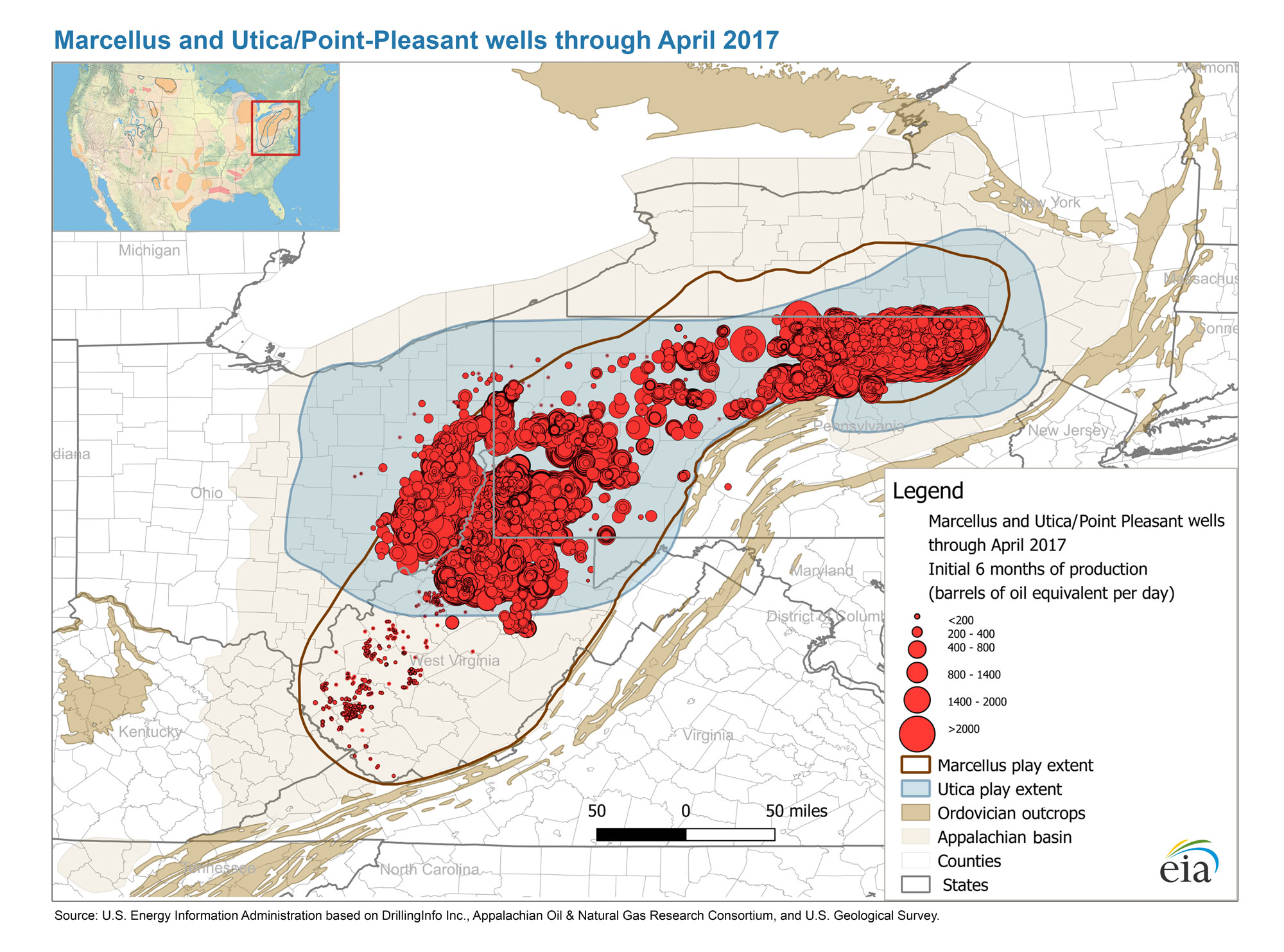
Petroleum production in the Devonian Marcellus and Utica/Point Pleasant shales as of April 2017. Map from the US Energy Information Administration.
Illinois Basin
The Illinois Basin, deepest in south-central Illinois, continues into western Kentucky and extreme north-central Tennessee. Similarly to the Appalachian Basin, oil and gas have been produced from Ordovician through Pennsylvanian-aged strata. The reservoirs are primarily structural and stratigraphic traps in Mississippian and Pennsylvanian sandstones that formed in a wide range of fluvial, coastal, and shallow marine environments. Some of these shallow-sea sandstones are very porous, making them effective reservoir rocks.
Many of the Illinois Basin's Mississippian limestones, which were deposited in shallow tropical seas, are also reservoirs. Some of these limestone layers are made of spherical grains called oolites that form along coastlines as concentric precipitated layers of calcium carbonate. These oolitic limestones are extensive and similar in age to the "Big Lime" of the Appalachian Basin.
Black Warrior Basin
The Black Warrior basin occupies northwestern Alabama and northeastern Mississippi. The first petroleum discovery in the region was made in 1909, when natural gas was struck in the Pennsylvanian-aged rocks of northwestern Alabama. Most traps in this basin are formed by folds and faults, and contain both oil and natural gas. Less oil is produced in this basin than in parts of the Appalachian Basin or the Illinois Basin to the north.
Other regions
Oil and gas are also produced in the "Cumberland Saddle," a sag along the Cincinnati Arch separating the Illinois and Appalachian Basins. In the Saddle, Cambrian and Ordovician rock units—tens of thousands of meters (yards) deep within the basins—are exposed at the surface. Substantial petroleum has been produced from limestones and dolomites of the Cambrian-Ordovician Knox Group in Tennessee and south-central Kentucky. Much of the petroleum from the Knox reservoirs was trapped in ancient sinkholes and caves along an unconformity, which marks a surface of erosion and weathering where the carbonates were exposed during a drop in sea level before being buried by the next marine transgression.
Natural asphalt
Natural asphalt or bitumen is present in rocks throughout the Inland Basin. In the Southeast, the most extensive deposits are found in Kentucky and Alabama. Natural asphalt was first discovered in Lawrence County, Alabama, in 1840. Alabama reserves contain at least 700 million tons of material, including around 100 million tons of petroleum, with limited production from 1927 to the present. Kentucky reserves contain at least 500 million tons.
Coal
Erosion of sediment from the Appalachian Mountains, which were formed by the assembly of Pangaea in the late Paleozoic, created vast coastlines and deltas in the Inland Basin. Widespread deposits of coal are associated with these areas. The main period of coal formation is known as the Carboniferous because of the abundant carbon (coal) found in rocks of this age. In the United States, the interval of time represented by the Carboniferous is divided into the Mississippian (major limestone and minor coal deposits) and Pennsylvanian (major coal deposits) periods.
Coal is plentiful in the Inland Basin thanks to local environmental conditions during the Mississippian and Pennsylvanian. Tropical climate, fluctuating sea levels, and basin subsidence (sinking) resulted in the cyclic growth and burial of vast peat swamps, some of which may have been among the largest tropical peat swamps of all time. The sea advanced and retreated hundreds of times, shifting the shoreline back and forth across the region and leaving hundreds of coal beds preserved when and where conditions were right for burial of peat.
Time, deep burial, and metamorphism transformed the peat layers into high grade anthracite and bituminous coal beds. Anthracite coals from Mississippian-aged peat swamps are preserved in the Valley Coalfields of Virginia, but none are presently mined.
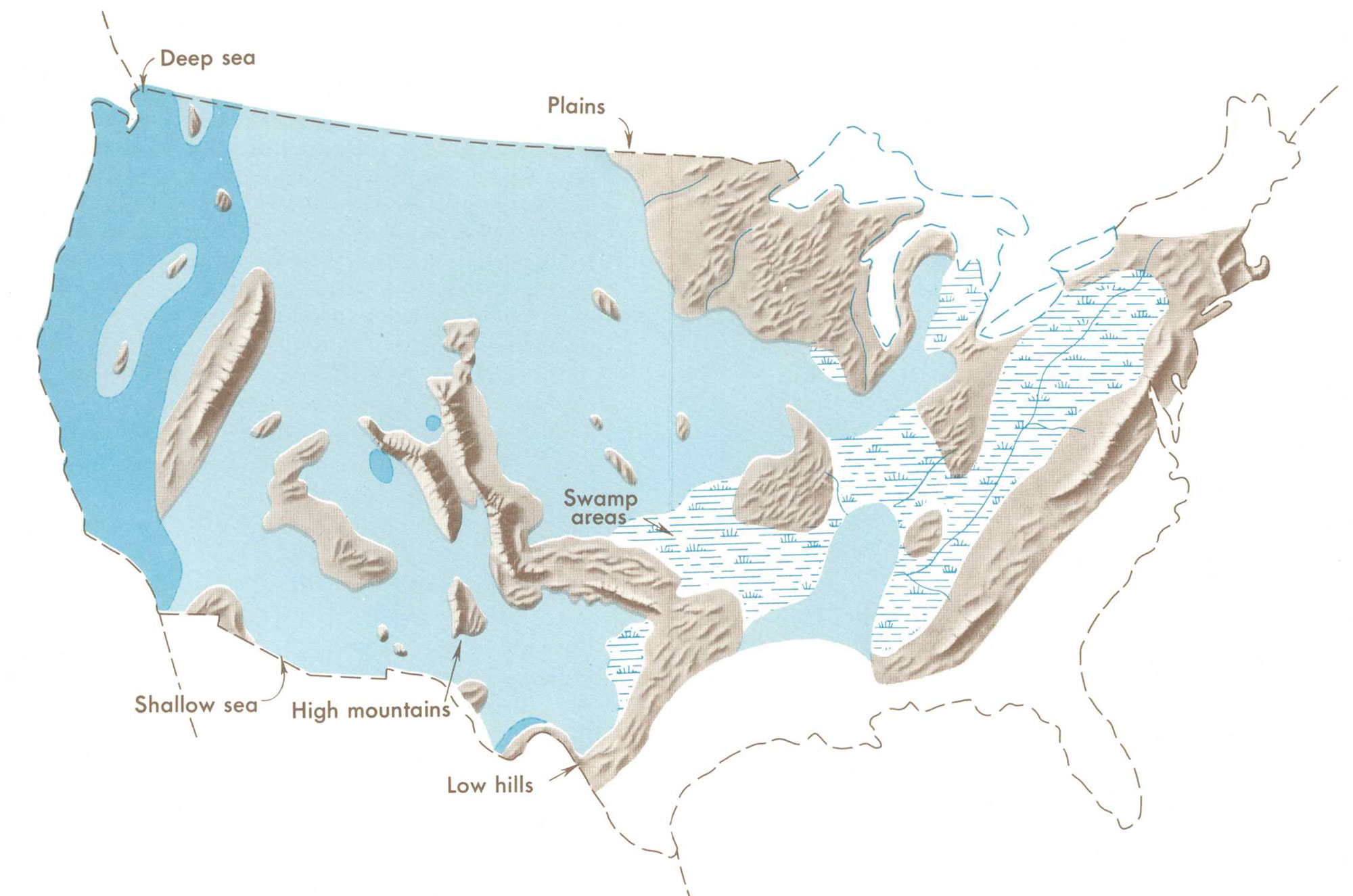
Distribution of Pennsylvanian swamps and highland areas relative to the outline of the modern United States. Map from Our changing continent, USGS Monograph, published 1969.
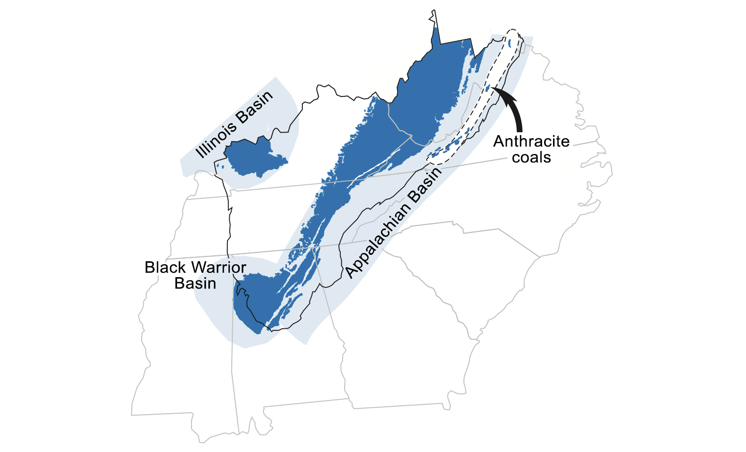
Bituminous and anthracite coal deposits of the Inland Basin region of the Southeast. Anthracite coals are found within the dashed circle in Virginia and West Virginia. Modified from original by Jim Houghton for the Earth@Home project.
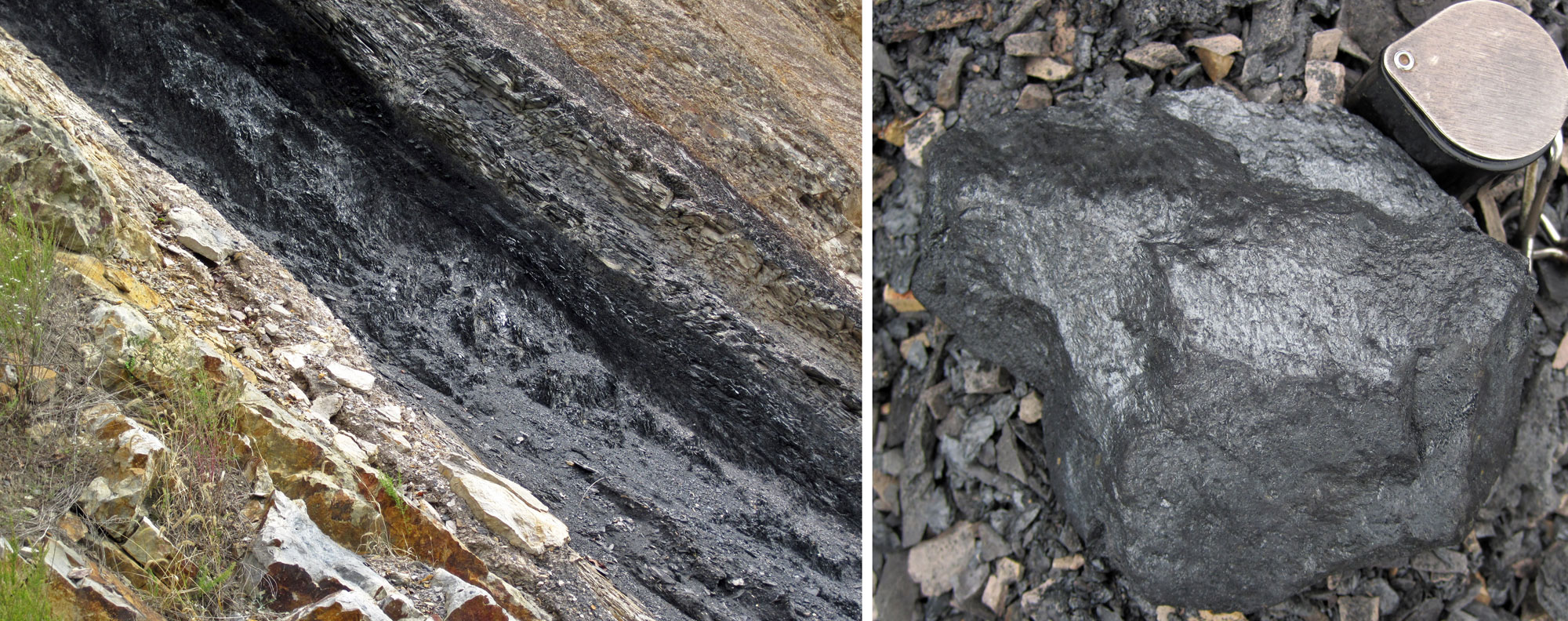
Mississippian Langhorne Coal, a semi-anthracite coal, Valley Coalfield Virginia. Left: Coal layer exposed in a roadcut. Photo by and caption based on James St. John (flickr, Creative Commons Attribution 2.0 Generic license, image cropped and resized). Right: Chunk of coal with hand lens for scale. Photo by and caption based on James St. John (flickr, Creative Commons Attribution 2.0 Generic license, image cropped and resized).
Coals deposited during the Pennsylvanian period occur in repeated successions of sedimentary rock layers known as cyclothems, which resulted from repetitive sea level changes caused by the formation and melting of continental glaciers on the supercontinent Gondwana from about 330 to 260 million years ago. Coal beds are preserved on the eastern margin of the elongate Appalachian Basin (including the Black Warrior Basin of Alabama), and in the Illinois Basin, which extends southward into western Kentucky. Vast, Pennsylvanian-aged coal deposits are present from West Virginia and western Virginia, across eastern Kentucky and Tennessee, and into northern Alabama. Lesser amounts of coal occur in Permian-aged strata in West Virginia.
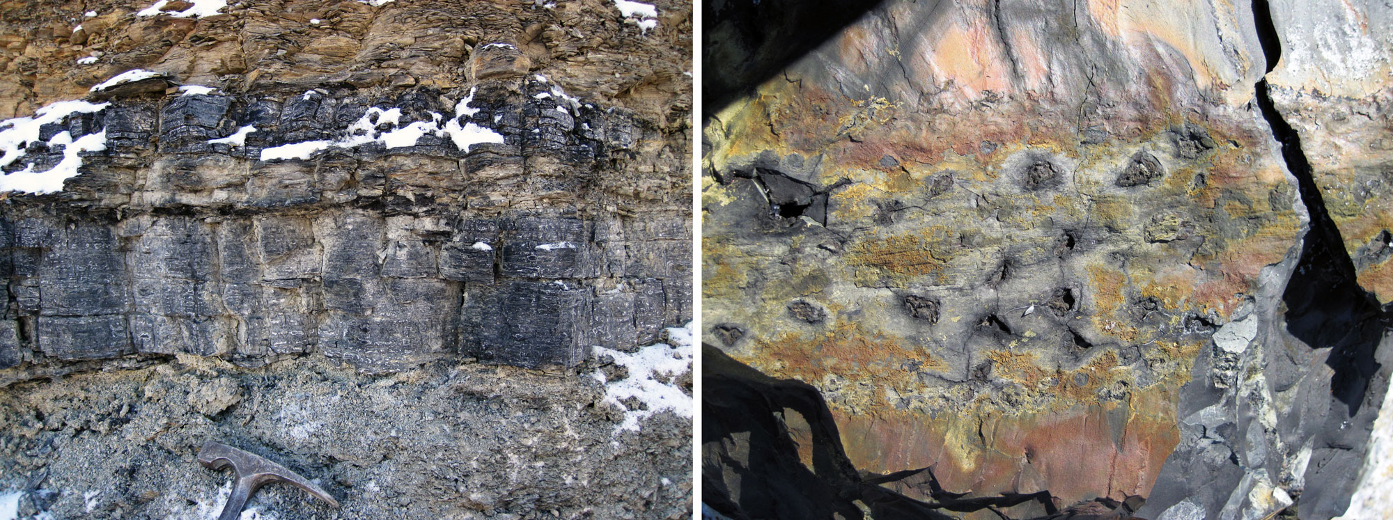
Bituminous coal deposits, middle Pennsylvanian Pikeville Formation, Breathitt County, Kentucky. Left: Thick coal layers. Information from and photo by James St. John (flickr, Creative Commons Attribution 2.0 Generic license, image cropped and resized). Right: Remains of Stigmaria, an organ that anchored Pennsylvanian-aged trees related to modern clubmosses. The pits in the coal are the sites of rootlets that were attached to a larger, branching rootlike structure known as a rhizomorph. Information from and photo by James St. John (flickr, Creative Commons Attribution 2.0 Generic license, image cropped and resized).
History of coal production
Coal in the Inland Basin was first reported along a tributary of the Kanawha River, West Virginia, in 1742. Initially, only small amounts of coal were used for heating by local blacksmiths or by settlers living near coal outcrops. In 1810, people in Wheeling, West Virginia, began using locally mined coal to heat their cabins.
The first steamboat on the Ohio River in 1811 burned coal from West Virginia, and coal began to replace charcoal as a fuel for the Kanawha River salt furnaces by 1817. In 1820, the first commercial mine opened in Kentucky. West Virginia produced about 300,000 tons of coal in 1840, of which two-thirds was used in the Kanawha salt furnaces. Factories and homes in Wheeling consumed most of the remainder. Production continued to expand until the outbreak of the Civil War, when coal production became a matter of military strategy. After the war, the Appalachian Basin coal industry began a rapid and sustained growth that paralleled the industrialization of the United States.
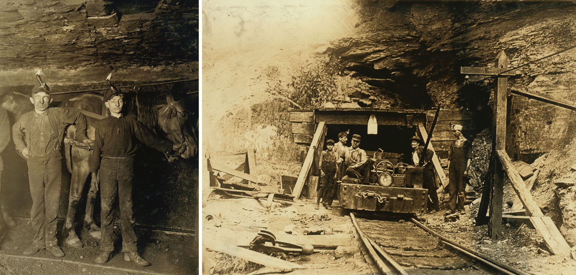
Left: Boys working in a coal mine, West Virginia, 1908. Photo by Lewis Wickes Hine (National Child Labor Committee Collection, Library of Congress, no known restrictions on publication). Right: Coal mine entrance, West Virginia, 1908. Photo by Lewis Wickes Hine (National Child Labor Committee Collection, Library of Congress, no known restrictions on publication).
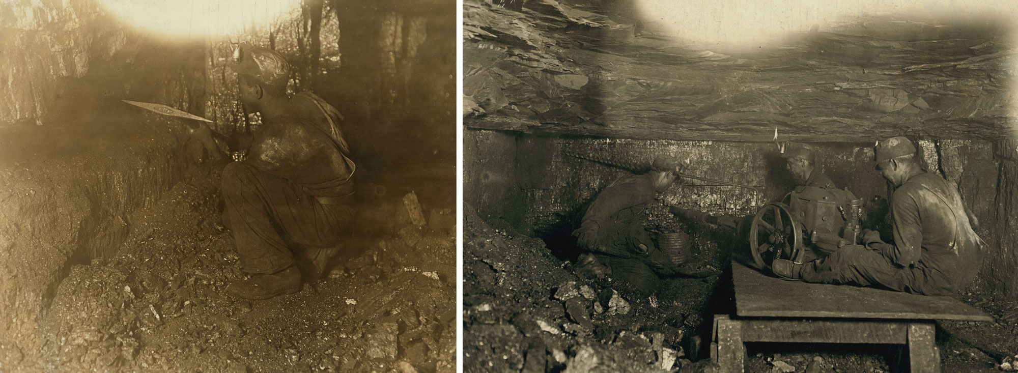
Left: Picking coal, Brown Mine, West Virginia, 1908. Photo by Lewis Wickes Hine (National Child Labor Committee Collection, Library of Congress, no known restrictions on publication). Right: Digging coal, Brown Mine, West Virginia, 1908. Photo by Lewis Wickes Hine (National Child Labor Committee Collection, Library of Congress, no known restrictions on publication).
Coal production today
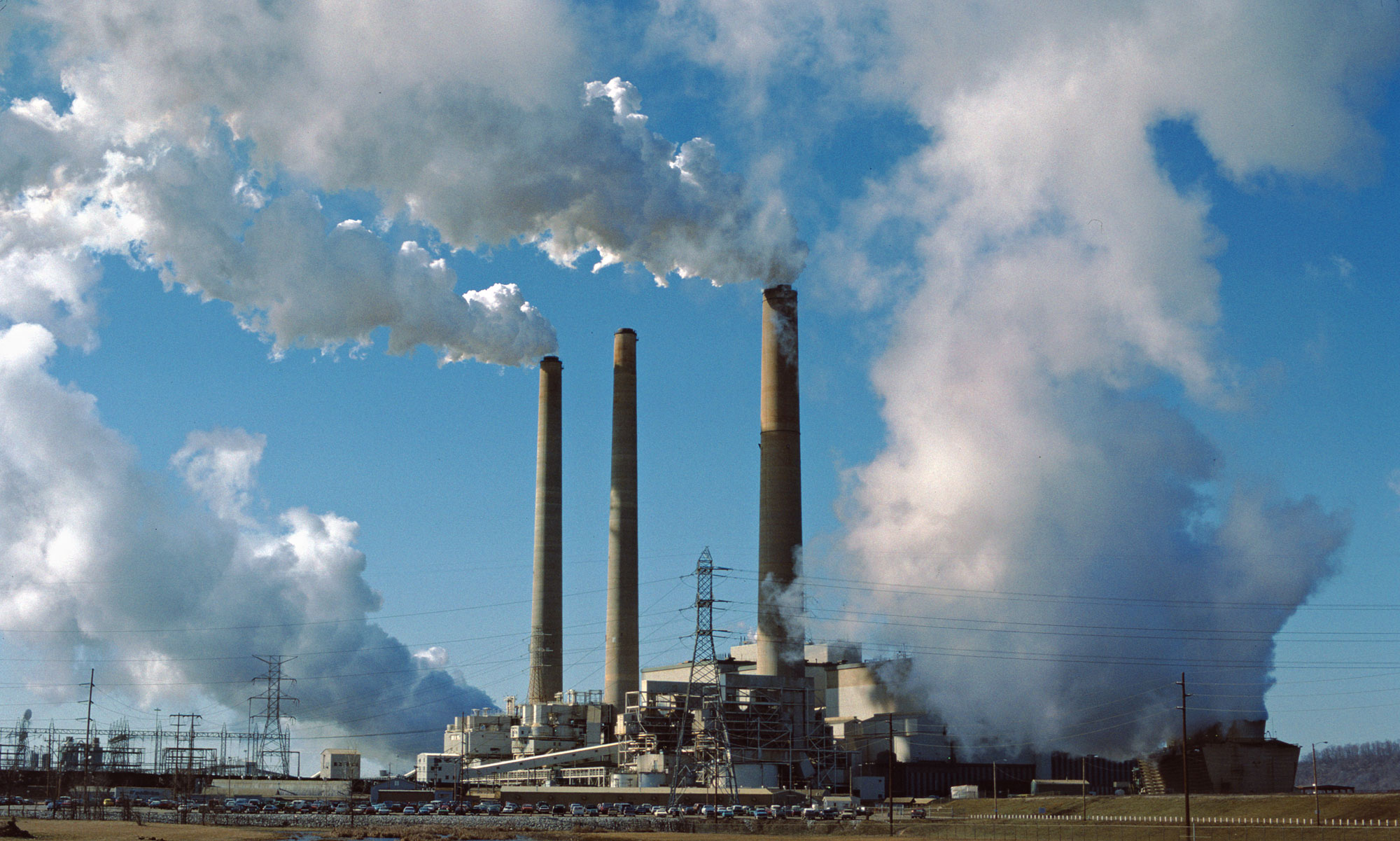
Coal is a major source of power in the Southeastern US, with power plants mostly using coal mined within the area. Kentucky and West Virginia are major centers for coal production and processing in the US. West Virginia provides coal to most of the Northeastern US, producing well over 100 million tons of coal per year.
The mining of Pennsylvanian coal is a major industry in Kentucky, Tennessee, Virginia, and West Virginia. More than 60 sites have been or are currently being mined in the southeast part of the Appalachian Basin and southern part of the Illinois Basin in western Kentucky. In 2013, West Virginia and Kentucky produced the second and third most coal in the country, accounting for 12% and 8%, respectively, of the national production.
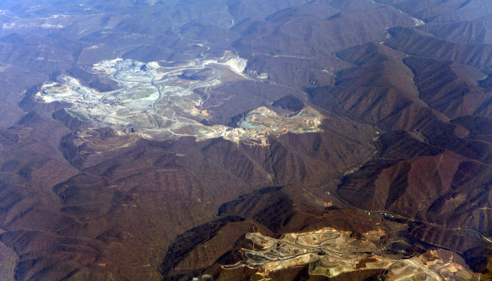
Well over half of the coal produced in the US in the last 180 years has come from deposits in the Appalachian Basin. Since the 1960s, coal in the Appalachians has been extracted using mountaintop removal mining, a method that involves blasting away the summit of a mountain to expose underlying coal seams. West Virginia and Kentucky each use approximately 1100 tons of explosives per day to facilitate this mining method.
In Alabama, coalbed methane is sometimes extracted in advance of underground coal mining. The Black Warrior Basin in northern Alabama and the Southwest Virginia Coalfield have hundreds of coalbed methane wells currently in operation. Virginia is the fifth leading state in coalbed methane production.
LG&E Mill Creek Generating Station, a coal-fired power plant in Louisville, Kentucky. Photo by William Alden (flickr, Creative Commons Attribution-ShareAlike 2.0 Generic license, image cropped and resized).
Mountaintop removal mining for coal in Kentucky, 2012. Photo by Doc Searls (flickr, Creative Commons Attribution 2.0 Generic license, image resized).
Hydroelectricity
The Appalachian Mountains to the east of the Inland Basin, combined with the Cumberland Plateau running through the region, facilitate hydroelectric power. Major hydropower plants dot rivers and lakes from the James River in West Virginia along the Cumberland River running through Kentucky and Tennessee to the Coosa River in Alabama. A substantial fraction of hydroelectric power in the Inland Basin comes from dams built by the Tennessee Valley Authority.
The Tennessee Valley Authority (TVA) was founded in 1933 by the US government to provide a wide range of services to promote economic development, including electricity generation, in the Tennessee Valley, which was hit especially hard by the Great Depression. The area covered the southern part of the Inland Basin—Tennessee and parts of states immediately north, south, and east. Numerous dams were built for hydroelectric plants, in the 1930s for economic development and in the 1940s for Word War II. Today, TVA remains a large public power utility, with 1/3 of its power from coal, 1/3 from nuclear, 1/10 from hydroelectric, and 1/10 from natural gas. It is beginning to add other sources of renewable energy, such as solar arrays and biofuels.
Alabama ranks fifth in the nation for renewable electricity generation, and is also one of the largest hydroelectric producers east of the Rocky Mountains. Southern Company, the largest electricity producer in the US, operates 34 hydropower facilities in Alabama and Georgia with a total of 2730 MW produced.
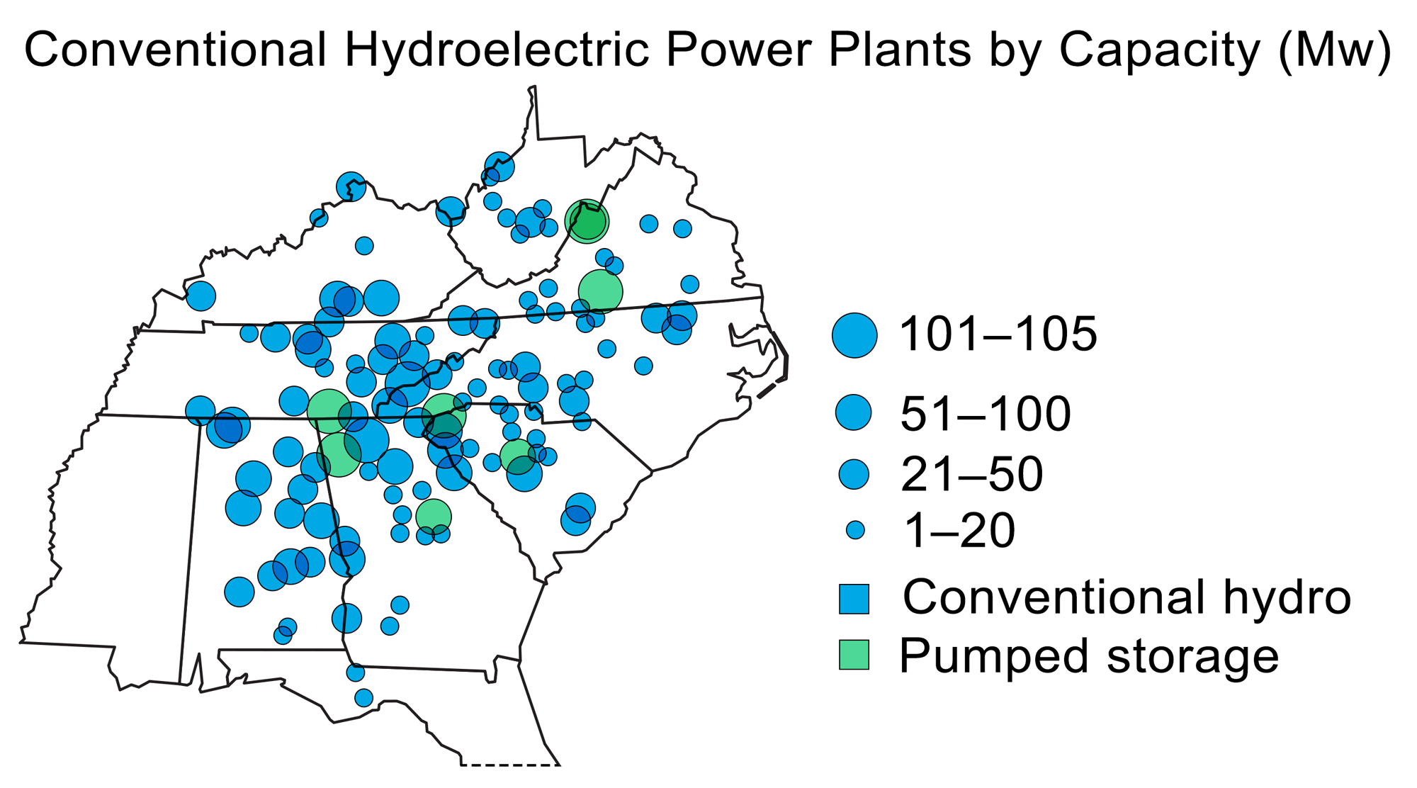
Hydroelectric power plants in the Southeastern US. Modified from the original by Wade Greenberg-Brand (adapted from image by US Energy Information Administration) for Earth@Home project.
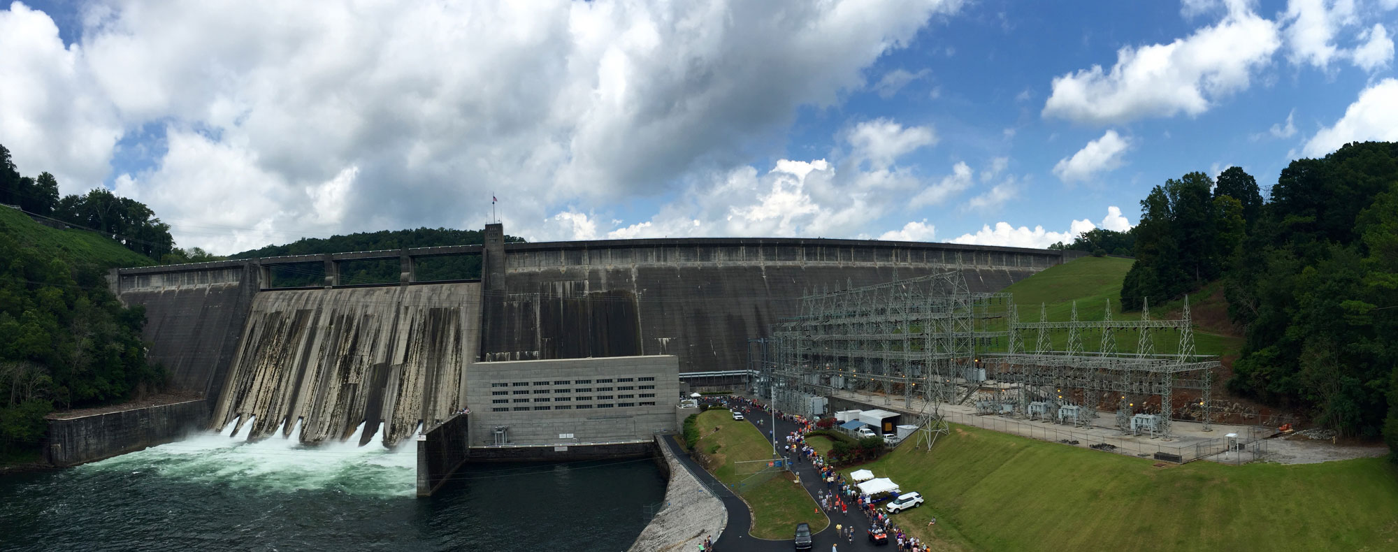
Norris Dam, a dam on the Clinch River in Tennessee, was built from 1933 to 1936 by the Tennessee Valley Authority. This photo was taken in 2016. Photo by the Tennessee Valley Authority (flickr, Creative Commons Attribution 2.0 Generic license, image resized).
Wind energy
The Southeast has one of the lowest wind resource potentials in the US, and has not been extensively developed for wind power. The primary exception is the spine of the Appalachians, which is oriented perpendicular to the prevailing winds and thus receives much higher average wind speeds; however, building large wind farms in tightly confined mountainous areas is logistically challenging.
West Virginia is the only state in the Southeast with significant existing wind energy production—in 2015, the state ranked about 25th in the US, with five plants producing a total of 615.3 MW of power. Tennessee has a single 2.1 MW wind farm.
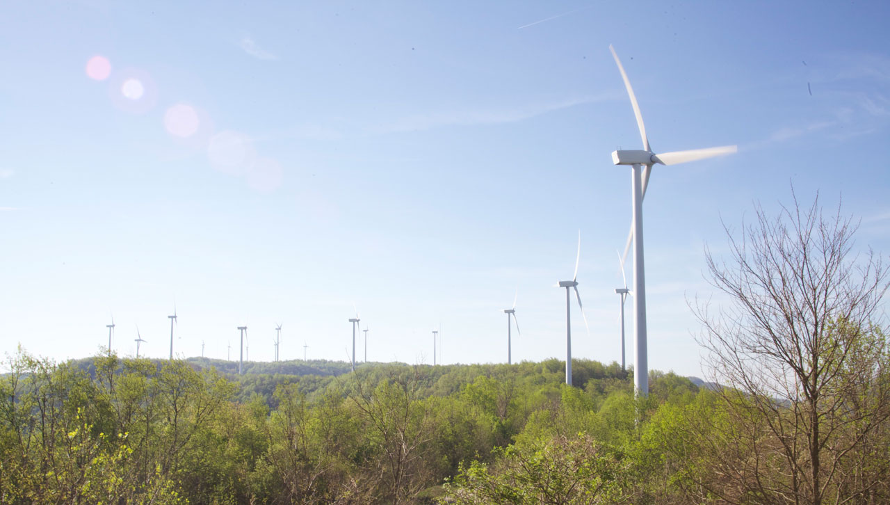
Buffalo Mountain Wind Farm, Tennessee, 2014. Photo by the Tennessee Valley Authority (flickr, Creative Commons Attribution 2.0 Generic license, image resized).
Nuclear power
Three nuclear power plants are located in the Inland Basin, two in Tennessee and one in Alabama. All three—the Watts Bar Nuclear Plant (1123 MW, Tennessee), the Sequoyah plant (2277 MW, Tennessee), and the Browns Ferry Nuclear Plant (3310 MW, Alabama)—are located along the Tennessee River.
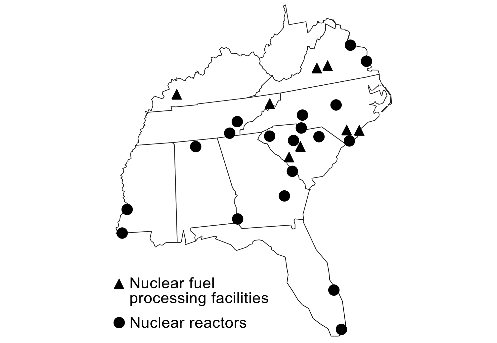
Production of nuclear power and locations of nuclear fuel processing facilities in the southeastern states. Modified from original by Wade Greenberg-Brand (adapted from images by the US Energy Information Administration and Kenny Moore via Wikimedia Commons) for the Earth@Home project.
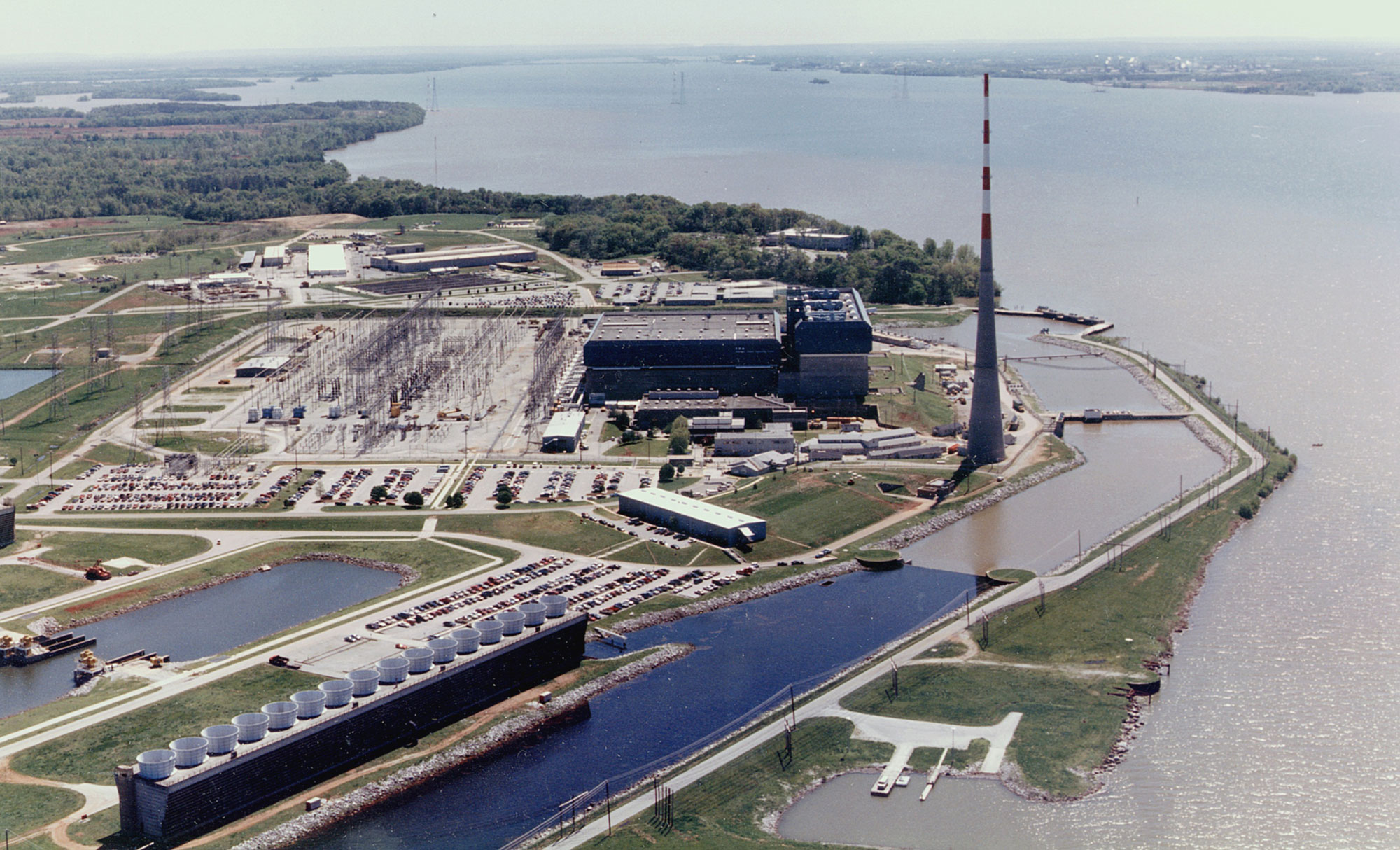
Browns Ferry Nuclear Plant, Alabama. Photo by the Nuclear Regulatory Commission (Wikimedia Commons, public domain).
Resources
Resources from the Paleontological Research Institution
Books
Duggan-Haas, D., R. M. Ross, and W. D. Allmon. 2013. The science beneath the surface: A very short guide to the Marcellus Shale. Paleontological Research Institution Special Publication 43, Ithaca, NY, 252 pp. PDF: https://www.priweb.org/science-education-programs-and-resources/the-marcellus-shale-the-science-beneath-the-surface
Websites
Earth@Home: Earth Science of the Midwestern U.S. (energy in the Inland Basin region of Illinois, Indiana, and Ohio): https://earthathome.org/hoe/mw/energy
Earth@Home: Earth Science of the Northeastern U.S. (energy in the Inland Basin region of Maryland, New York, Pennsylvania, and Vermont): https://earthathome.org/hoe/ne/energy/