

Page Snapshot: Introduction to Earth hazards in the southwestern United States.
Contents
Topics covered on this page: Landslides; Earthquakes; Karst and Sinkholes; Asbestos; Radon; Floods; Weather hazards; Climate change; Resources.
Credits: Most of the text on this page comes from "Earth Hazards of the Southwestern US" by Sue Luke P. McCann and Andrielle N. Swaby, chapter 9 in The Teacher-Friendly Guide to the Earth Science of the Southwestern US, edited by Andrielle N. Swaby, Make D. Lucas, and Robert M. Ross (published in 2016 by the Paleontological Research Institution). The book was adapted for the web by Elizabeth J. Hermsen and Jonathan R. Hendricks in 2021–2022. Changes include formatting and revisions to the text and images. Credits for individual images are given in figure captions.
Updates: Page last updated April 14, 2022.
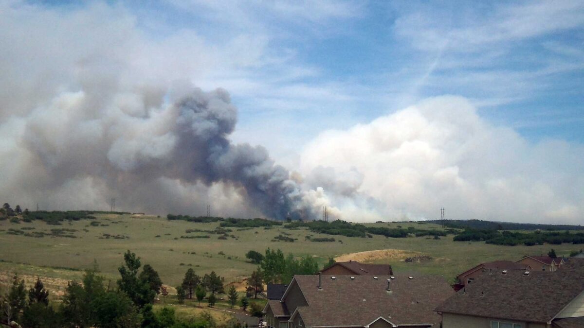
Image above: Smoke rising from the 2013 Black Forest Fire in Colorado. This fire destroyed over 500 homes and two people lost their lives; over 14,000 acres were burned. Photograph by State Farm (Flickr; Creative Commons Attribution 2.0 Generic license; image cropped and resized).
Introduction
Natural hazards or earth hazards are events or processes that have significant impacts on human beings and the environment. Extreme weather conditions or geologic activity can cause substantial short-term or long-term changes to our environment. These changes can influence many aspects of the world around us, including crops, homes, infrastructure, and the atmosphere. The 4.6-billion-year-old Earth has experienced many naturally generated hazards, while other events are byproducts of human activities, created during mineral and energy extraction or in construction practices that modify the landscape.
The Southwest, like any other part of the U.S., has numerous hazards—based largely on its geography—that directly infringe upon people’s property and safety. Dangerously hot weather and drought are commonplace in the Southwest’s arid environment. Weather hazards such as tornados, thunderstorms, and winter storms frequently occur over the Great Plains, thanks to the unobstructed movement of air masses over areas of low topographic relief. The Rocky Mountains are susceptible to extreme winter weather such as heavy snow, blizzards, and high winds. Flooding can occur in areas of low elevation and along large rivers. Geological hazards, including avalanches, earthquakes, landslides, and rockfalls, also occur throughout the Southwest, especially in areas with rugged, mountainous terrain.
Landslides
Landslides are common in mountainous parts of the Southwest thanks to a combination of steep terrain, poorly consolidated sediments, and melting snowpack that leads to soil saturation.
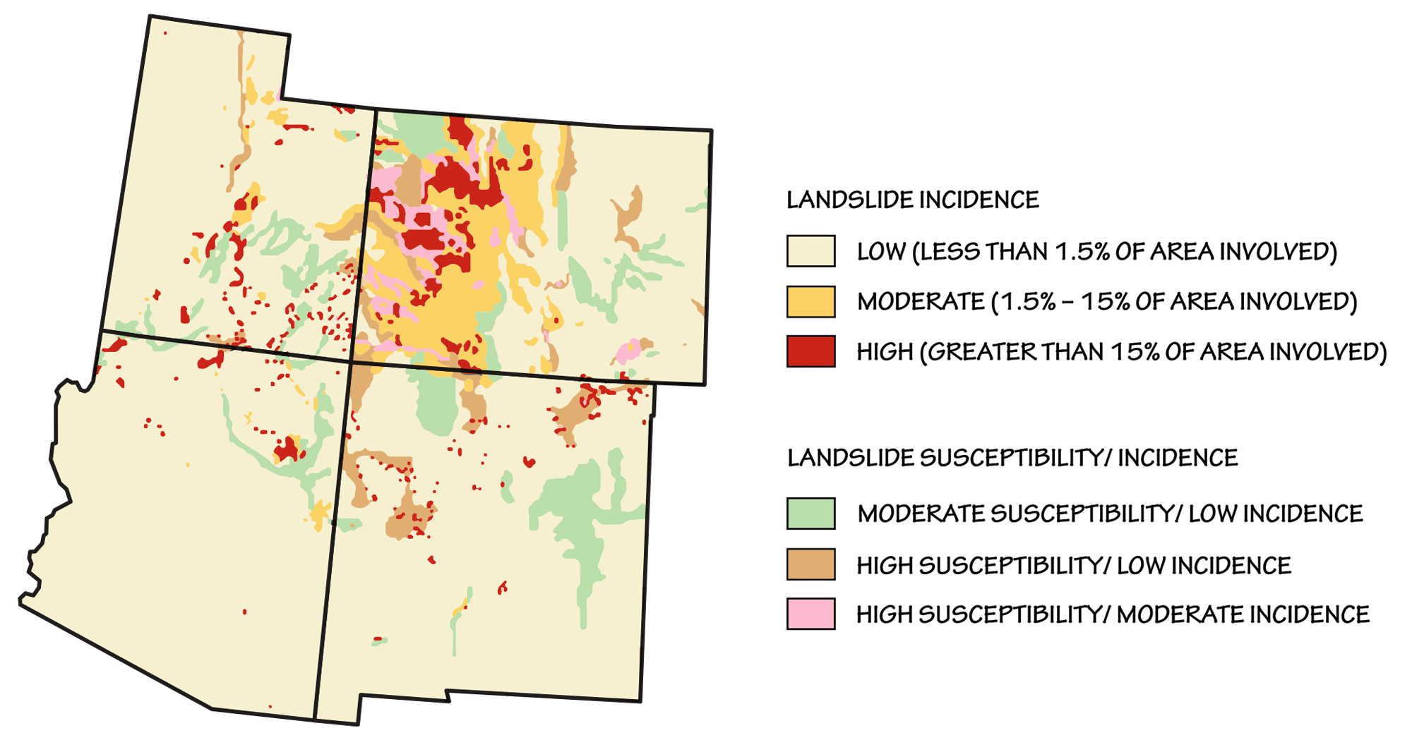
Landslide incidence and risk in the southwestern United States. Adapted from image by the USGS (public domain).
They often occur in high valleys with little vegetative cover. In years that are particularly wet or rainy, landslide incidence increases as unstable soils on saturated slopes break free of the rock. Some very fast landslides can reach speeds exceeding 32 kilometers per hour (20 miles per hour). Although many slides in the Rockies are small, or take place in remote and inaccessible locations, people and property are impacted each year by these events.
In the winter, many of the same mountainous areas that are prone to landslides during the year are subject to avalanches—rapid flows of snow, ice, and rock. Avalanches occur when the strength of the snow is overcome, or when a weak layer in the snow fails. These snow failures can result from storms, warming weather, sunny slopes, earthquakes, and people moving over the snow. Hundreds of avalanches occur every winter in the mountains of Colorado and Utah. Utah has seen some of the largest landslides in US history. In April 1983, a massive landslide dammed the Spanish Fork River, destroying roads and flooding the town of Thistle with more than 80 million cubic meters of water that backed up behind the naturally formed dam.
"Thistle Slide" by abc4utah (YouTube).
This dam eventually created a lake 60 meters (200 feet) deep and 5 kilometers (3 miles) long. Thistle was almost completely destroyed, and the nearby railroad and highways had to be rebuilt on higher ground. While these transportation routes were closed, communities in eastern and southeastern Utah were completely cut off from the rest of the state for up to eight months. Direct and indirect costs of the Thistle landslide have been estimated to be as high as $950 million (adjusted for inflation); the state of Utah and the United States Geological Survey have categorized this landslide as the costliest in the nation.
More recently, in April 2013, a massive landslide at Utah’s Bingham Canyon Mine (also known as the Kennecott Copper Mine) displaced almost 70 million cubic meters (2.5 billion cubic feet) of dirt and rock from the side of the pit. This was the largest nonvolcanic landslide in the history of North America; luckily, thanks to an early warning system, no injuries occurred.
"80. Manefay Landslide 2013 Largest in History" at Bingham Canyon Mine by "Bingham Canyon and Copper King Mine" (YouTube).
Massive landslides in Utah aren’t just restricted to recent history, either. In 2014, scientists in Dixie National Park discovered the remnants of the largest known landslide anywhere on earth. This major prehistoric slide occurred 21 million years ago and stretched over 2700 meters (1700 miles)—an area the size of Rhode Island. Geologists studying the site have concluded that it originated when a volcanic field collapsed, and took place over an extremely short period of time, during which the friction of moving blocks pulverized and even melted the surrounding rocks.
Mudflows or earthflows are fluid, surging flows of debris that have been fully or partially liquefied by the addition of water. They can be triggered by heavy rainfall, snowmelt, or high levels of ground water flowing through cracked bedrock. Higher temperatures, thick melting snowpack, and an increase in spring rainstorms are thought to have generated the 2014 mudflow in Mesa County, Colorado, in which a slide five kilometers (three miles) long and 1.2 kilometers (¾ of a mile) wide claimed the lives of three men as well as triggered a small earthquake.
"Raw: Aerials Show Colorado Mudslide" by the Associated Press (YouTube).
The Grand Mesa area, where the slide occurred, is prone to landslides due to a soft underlying layer of claystone that erodes easily from runoff and snowmelt.
Debris flows are a dangerous mixture of water, mud, rocks, trees, and other debris that moves quickly down valleys. The flows can result from sudden rainstorms or snowmelt that creates flash floods. In Chalk Cliffs, Colorado, one or more small debris flows occur every year after periods of intense rainfall. Though less hazardous than debris flows that occur in populated areas, these deposits have blocked roads and diverted streams.
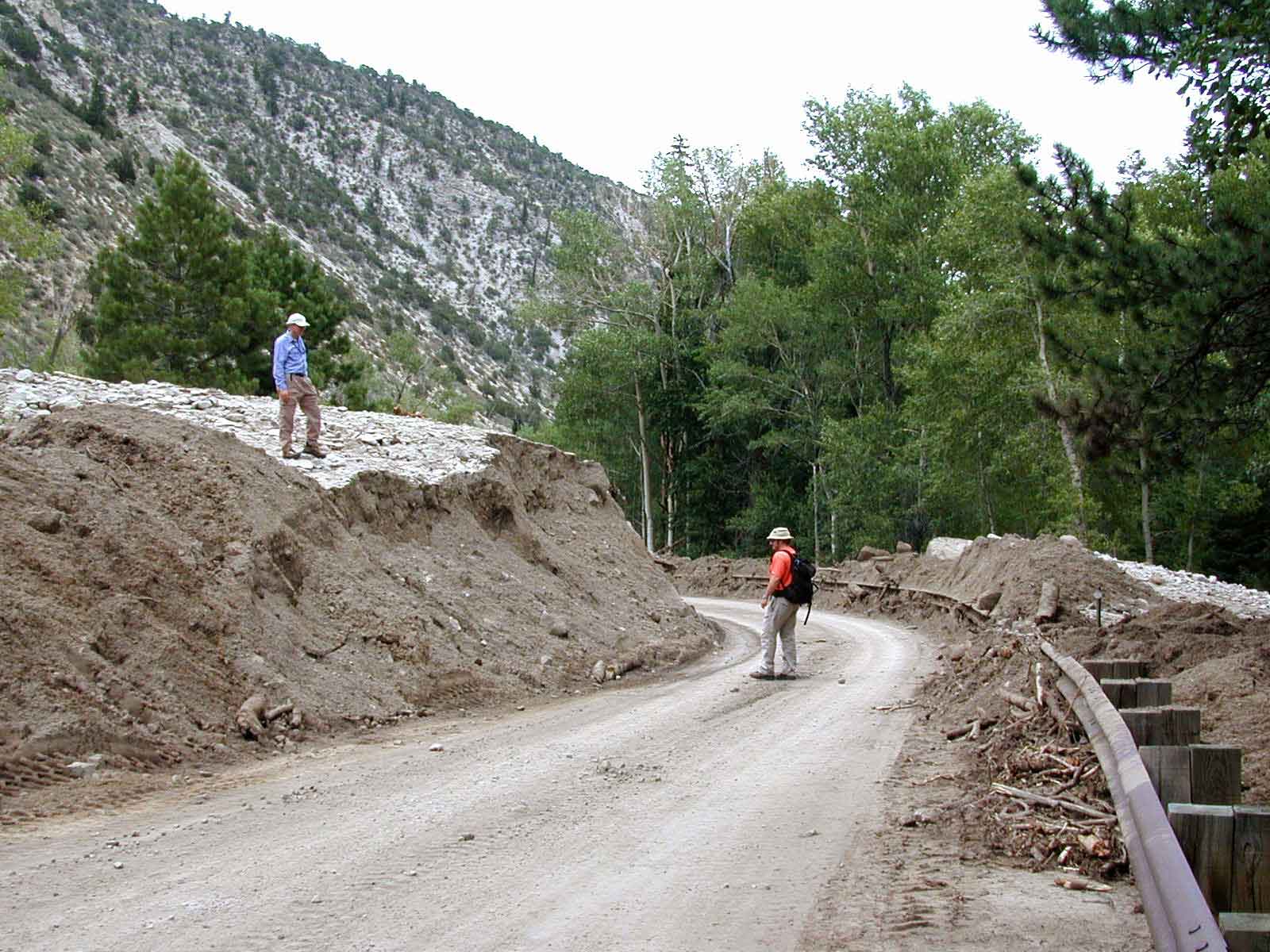
Remnants of a 2002 debris flow near Buena Vista, Colorado, which blocked Chaffee County Road 306 in 11 places and trapped several motorists. Photograph by USGS (public domain).
Debris flows can also occur in otherwise stable landscapes after the occurrence of large wildfires, which can destabilize the ground due to the removal of vegetation and desiccation of the soil. Heavy rainfall following the fire can then cause the burned slopes to fail. The Sandia and Manzano Mountain areas in central New Mexico have been studied extensively regarding their susceptibility to post-wildfire debris flows.
In the Rocky Mountains, where the bedrock contains many discontinuities (folded bedding planes, faults, joints, and cleavage) resulting from several episodes of mountain building (the Antler, Laramide, and Sevier orogenies), rock slides and rockfalls are common, especially along transportation routes running through the mountains. US Highway 6 in Colorado, State Route 9 (the Zion-Mount Carmel Highway) in Utah, and I-70 in west-central Colorado are often impacted by rockfalls, leading to frequent road closures. In 2020 a viral tweet from the San Miguel County, Colorado's sheriff's department alerted travelers to a "Large boulder the size of a small boulder" blocking a portion of Highway 145.
"The lady who wrote the 'large boulder the size of a small boulder' tweet reads her favorite replies" by 9NEWS (YouTube).
Stretches of highway can remain closed for periods of several months. Rockfalls can also have fatal consequences in populated areas where buildings have been constructed in high-hazard zones.
"Massive boulders in Utah hit home, killing two" by CNN (YouTube).
Not all mass wasting events are rapid—slow land movement, known as soil creep, is generally not hazardous, but can impact structures over a long period of time. Slumps and creep are common problems in parts of the Southwest with a wetter climate and/or the presence of unstable slopes, especially in the Great Plains and on the Colorado Plateau. Many areas in the Southwest contain expansive soils generated from clay-rich parent materials, especially volcanic ash or debris. Certain clay minerals can absorb water and swell up to twice their original volume. The pressures exerted through expansion of the minerals in the soil can easily exceed 22 metric tons per square meter (5 tons per square foot)—a force capable of causing significant damage to highways and buildings. An estimated $9 billion of damage to infrastructure built on expansive clays occurs each year in the United States, making swelling soils one of the costliest hazards. In addition, when the clay dries and contracts, the particles settle slightly in the downhill direction. This process can result in soil creep, a slow movement of land that causes fences and telephone poles to lean downhill, while trees adjust by bending uphill.
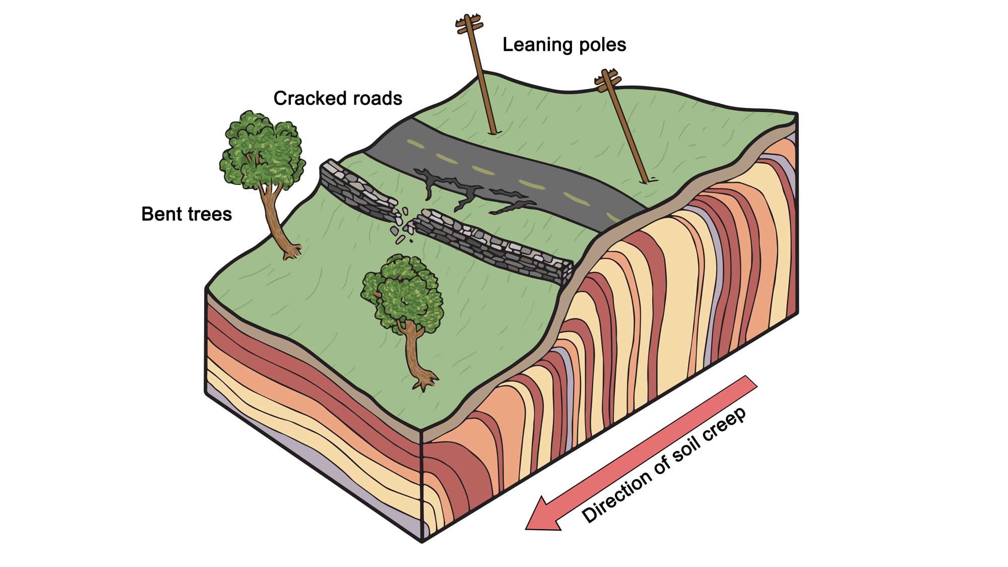
Some of the effects of soil creep on surface topography and structures. Note that subsurface colored layers are meant to depict movement, not stratigraphic layering of soil. Modifed from original by Wade Greenberg-Grand for the Earth@Home project.
Human development can exacerbate this process when homes are built along steep embankments, disturbing vegetation that would otherwise stabilize the slope or adding water to the land in the form of yard irrigation or septic systems.
Expansive soils can be found all over the U.S., and every state in the Southwest has bedrock units or soil layers that are possible sources.
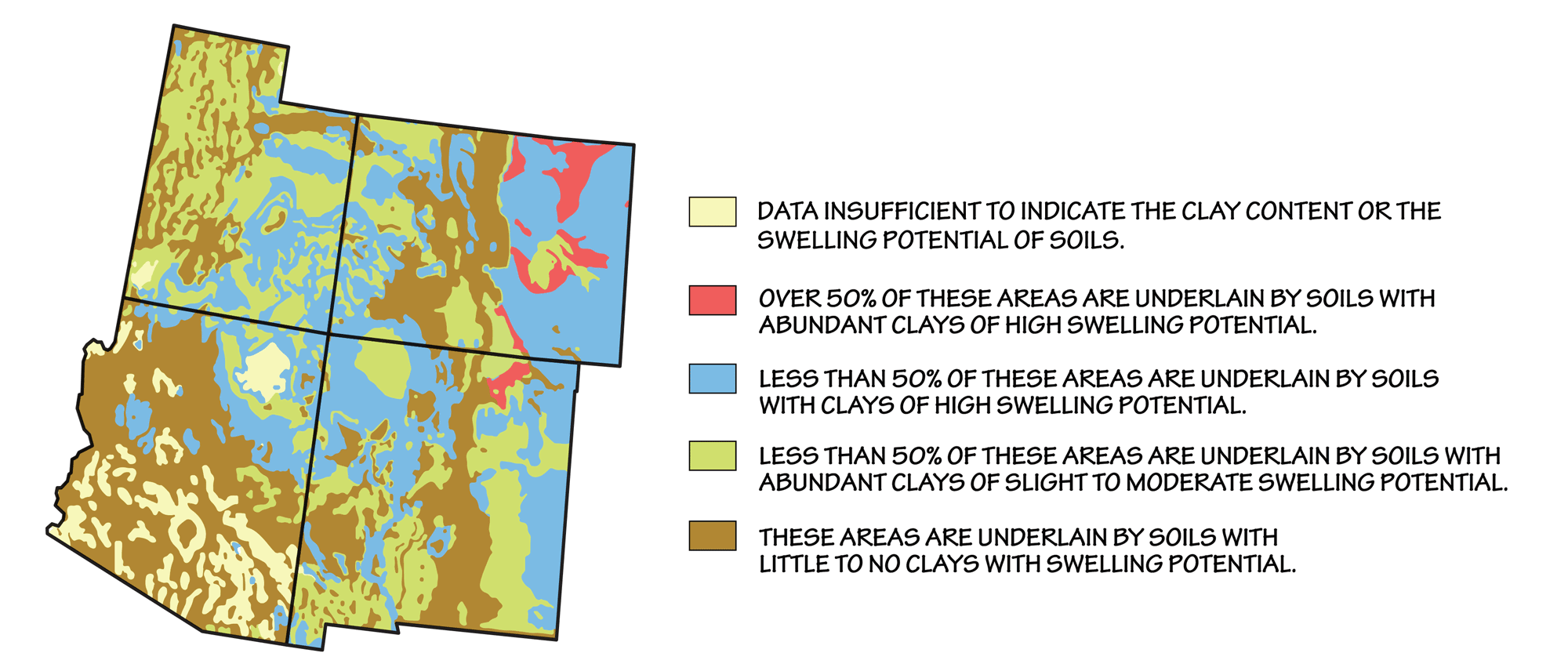
Approximate distribution of expansive soils in the Southwestern U.S. This map is based on the distribution of types of bedrock, which are the origin of soils produced in place. (Where substantial fractions of the soil have been transported by wind, water, or ice, the map will not be as accurate.) Map by Wade Greenberg-Brand, adapted from map by the USGS (public domain).
Clay minerals that expand and contract when hydrated and dehydrated due to their layered molecular structure are generically referred to as smectite; soils that tend to form deep cracks during drought are often indicative of the presence of smectite. The Colorado Plateau and Great Plains regions have the highest risk of damage caused by swelling soil. Here, clays are typically composed of montmorillinite or bentonite, which have a very high shrink/swell potential. In the Basin and Range, the clay-rich beds of the Pantano Formation are prone to expansion, as are old alluvial fan surfaces along river terraces.
Significant or repeated changes in moisture, which can occur from human use or in concert with other geologic hazards such as earthquakes, floods, or landslides, greatly increase the hazard potential of expansive soils. Because precipitation is infrequent in much of the Southwest, low-moisture soils also have a high potential for hydrocompaction, where dry silt and clay particles lose their cohesion upon wetting. This process causes the soil to collapse, settling lower. If hydrocompaction occurs over deeper layers that have been severely dried due to prolonged drought or receding groundwater levels, the settling topsoil may fall into and expose giant underground fissures, called desiccation cracks.
"Understanding Earth Fissures: A Man-Made Geohazard" by geosociety (YouTube).
These fissures can be up to a meter (3 feet) wide, 3 meters (9 feet) deep, and as much as 300 meters (1000 feet) long.
Earthquakes
Earthquakes occur less frequently in the southwestern U.S. than they do in some other regions, but modest-sized earthquakes nonetheless represent potential hazards for the Southwestern states. Notable earthquakes that have occurred just outside the Southwestern states, such as the 1887 Sonoran earthquake (M7.4) and the 1940 Imperial Valley earthquake (M7.1), have also caused extensive shaking and property damage, especially in Arizona.
Notable earthquakes of the southwestern United States
| Date | Location | Magnitude (Mw) |
|---|---|---|
| 1934 (March 12) | Kosmo, UT | 6.6 |
| 1882 (November 8) | Denver, CO | 6.6 |
| 1906 (November 15) | Socoito, NM | 6.5 |
| 2020 (March 18) | Salt Lake City, UT | 5.7 |
| 1959 (July 21) | AZ-UT border | 5.6 |
| 1992 (September 2) | Springdale, UT | 5.6 |
| 1967 (August 9) | Denver, CO | 5.3 |
| 2011 (August 22) | Trinidad, CO | 5.3 |
| 2014 (June 29) | NM-AZ border | 5.2 |
| 1966 (January 23) | Dulce, NM | 5.1 |
A 5.7 magnitude earthquake rattled Salt Lake City on March 18, 2020, causing some damage to buildings, but no loss of life.
"Team Coverage: 5.7 earthquake hits Utah" by FOX 13 News Utah (YouTube).
Large earthquakes are relatively uncommon in the Southwestern US, due to the area’s distance from current plate boundaries—the Southwest is located in the center of a tectonic plate rather than at an active plate margin. All earthquakes that occur in the Southwestern US are therefore referred to as “intraplate” earthquakes, and they are largely related to faults that localize earthquakes in particular areas, along linear seismic belts or zones. Many of the largest earthquakes in the Southwest, especially those in the Rocky Mountains, stem from activity along the Intermountain Seismic Belt.
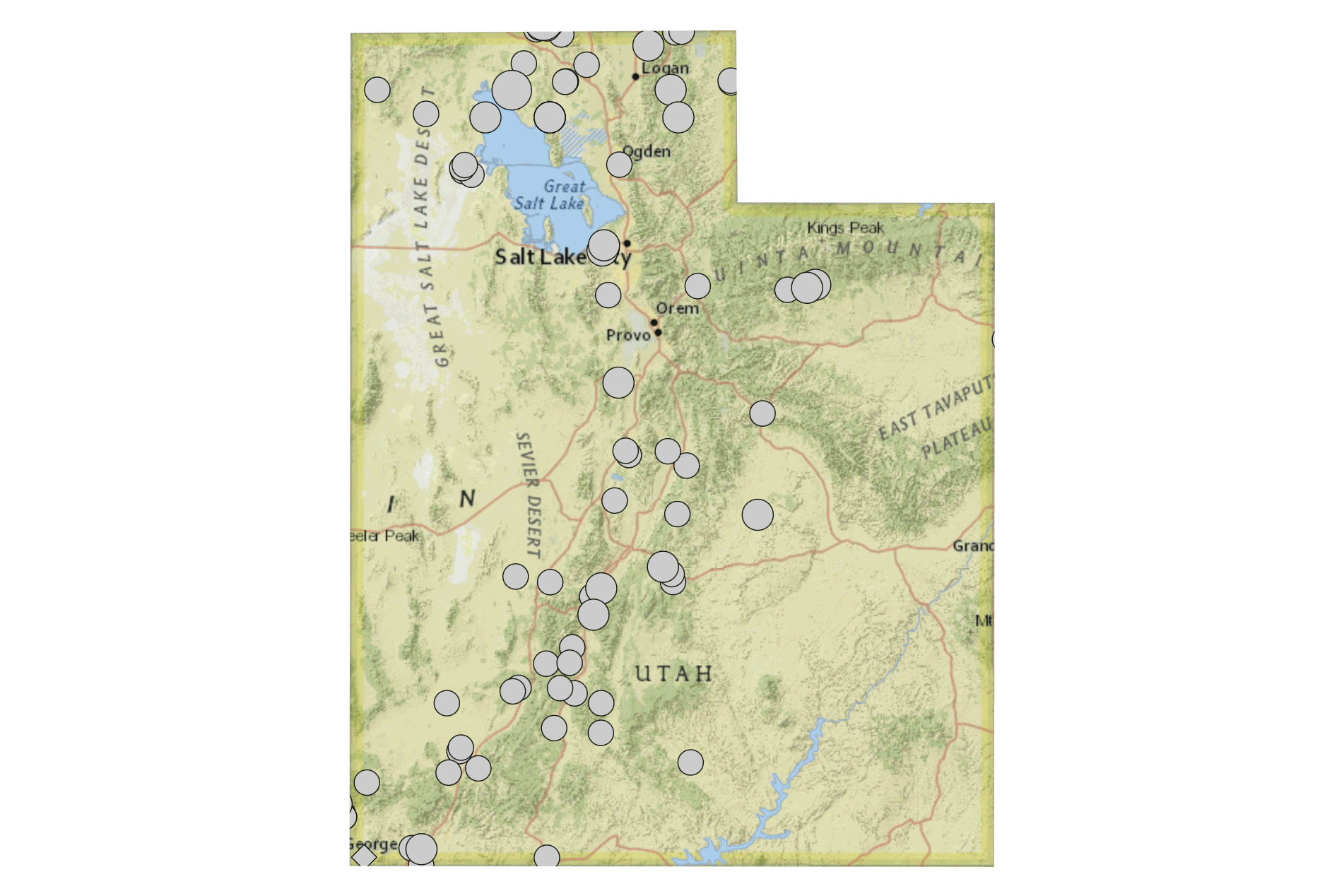
Epicenters of earthquakes in Utah with magnitudes greater than 4.0. All have occurred in or near the Intermountain Seismic Belt. Image by Jonathan R. Hendricks using the USGS Earthquake Catalog (public domain).
This linear zone of earthquake activity extends 1290 kilometers (800 miles) from northwestern Montana southward along the Idaho-Wyoming border, through Utah, and into southern Nevada. Many active fault lines occur along this belt; the largest and most active is the Wasatch Fault, which marks the eastern edge of Basin and Range extension.
Geologic studies indicate that the Wasatch Fault has experienced 19 or more surface-faulting earthquakes in the last 600 years. Some of these prehistoric earthquakes displaced the land surface by as much as 3 meters (10 feet) in a 30- to 65-kilometer (20- to 40-mile) radius, while others formed fault scarps over 6 meters (20 feet) high. Because the Wasatch Front is such a desirable place to live—about 80% of Utah’s population resides along this mountain range, known for its spectacular views—the area is designated as having the greatest earthquake risk in the interior western U.S. Scientists estimate that the Wasatch Range has a 1-in-7 chance of being hit by a M7.0 earthquake sometime in the next 50 years.
The Northern Arizona Seismic Belt is an offshoot of the Intermountain Seismic Belt that extends south into Arizona along the Colorado Plateau. Faults in this zone are Quaternary in age, and are thought in part to have formed due to stress between the Basin and Range and edge of the Colorado Plateau. Swarms of tiny earthquakes occur along these fault lines in Arizona every year, most too small to be felt. Major quakes can and do occur, though, and geologists are keeping a close eye on the Anderson Mesa Fault near Flagstaff, which could conceivably produce an earthquake between M5.0 and M6.5. Earthquakes can also occur through human causes, or “induced seismicity.” These events are specifically linked to the high-pressure injection of wastewater from oil and gas extraction operations into the ground. The pressure of the water increases the likelihood that a rupture might occur along an otherwise locked fault. In early 2016, the U.S. Geological Survey released a list of states considered to be at the highest risk for manmade earthquakes. Colorado and New Mexico rank fourth and fifth respectively due to the presence of the Raton Basin, an important source of coalbed methane and natural gas.
Karst and sinkholes
Karst topography forms in areas where the underlying bedrock is composed of material that can be slowly dissolved by water. Many parts of the Southwest are underlain by karst and soluble carbonate bedrock, especially Arizona’s Colorado Plateau and New Mexico’s Basin and Range.
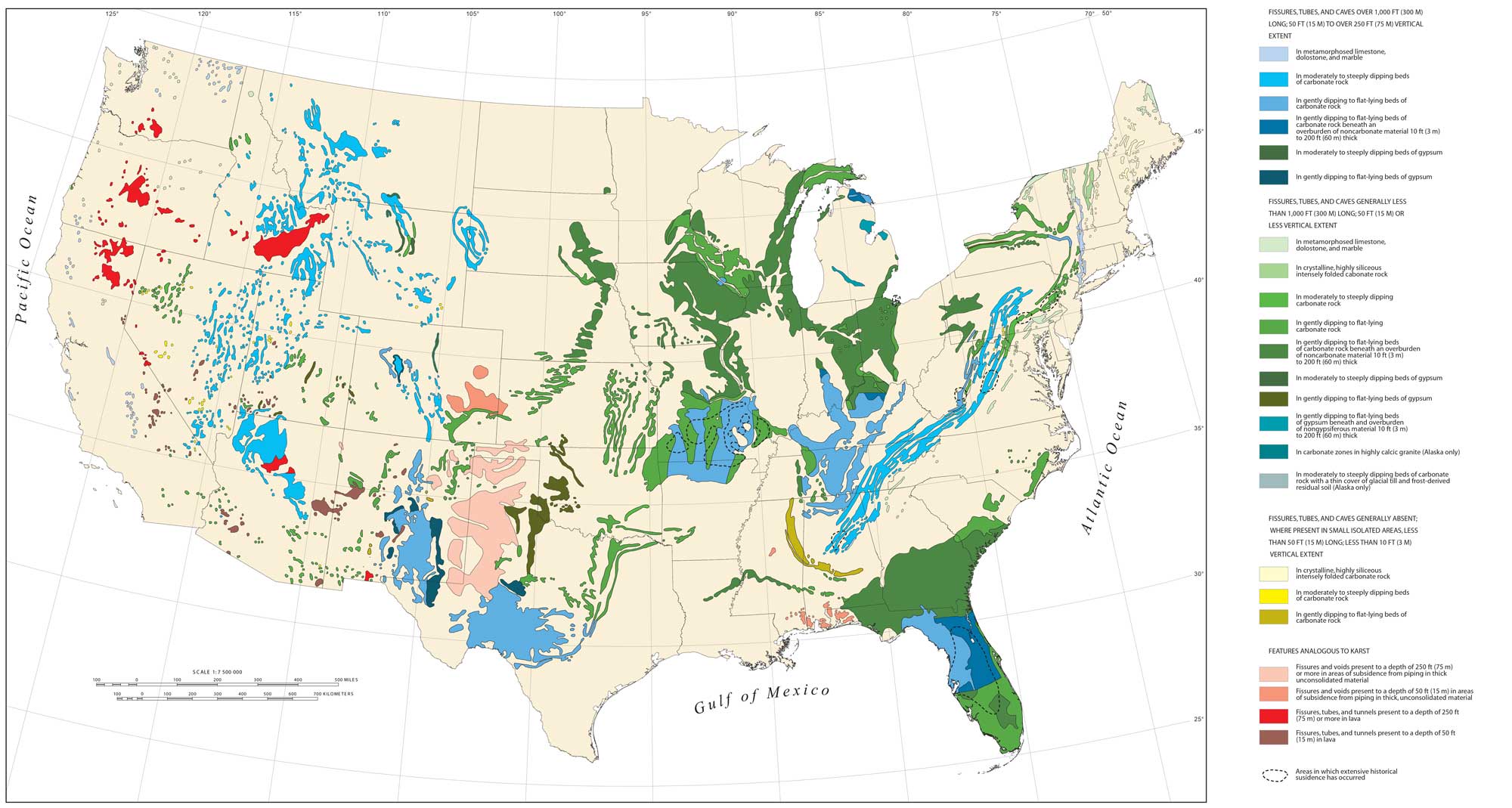
Areas of karst in the continental United States that are associated with carbonate and evaporate rocks. Image by Tobin and Weary (USGS; public domain).
The Colorado Plateau of northern Arizona contains extensive surface limestone and subsurface gypsum/salt deposits. As these beds dissolve beneath the surface through the movement of groundwater, sinkholes form through the collapse of overlying layers. Karst features such as open caverns also commonly form at the surface. The mountains of southeastern Arizona also contain limestone layers that have dissolved to form caverns such as Colossal Cave near Tuscon—these features are less extensive than those on the Plateau and collapse at the surface is uncommon. In New Mexico, karst is concentrated in the northern Sacramento Mountains and the Guadalupe Mountains, where a large number of impressive caverns (including Carlsbad Cavern) have formed in Permian reef limestone.
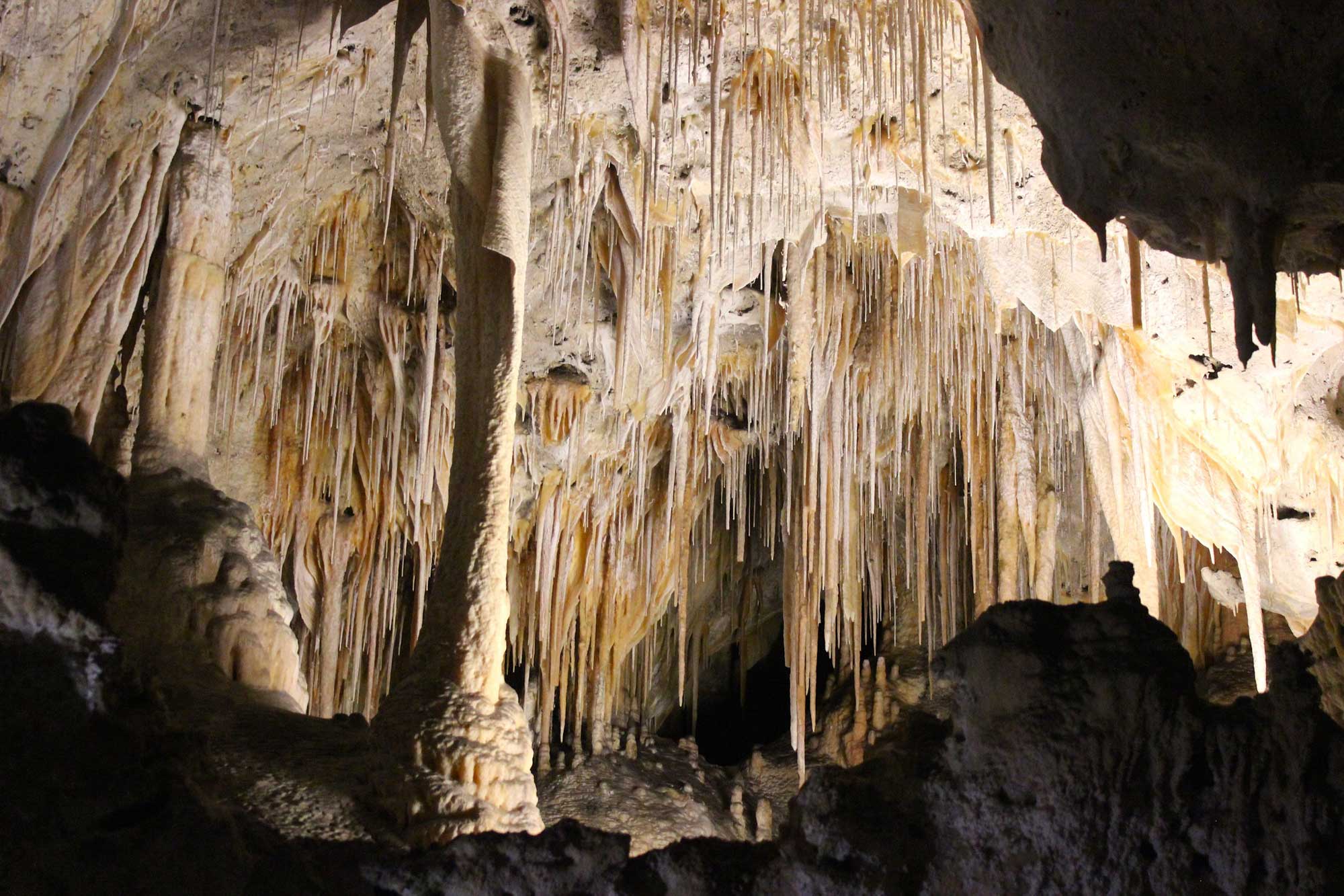
Delicate limestone speleothems decorate Carlsbad Caverns, New Mexico, in an array of spectacular formations. Photograph by "Jessica D" (Flickr; Creative Commons Attribution-NonCommercial-ShareAlike 2.0 Generic license).
Although karst collapse is less prevalent in New Mexico than in many other parts of the United States, it is still an environmental issue of concern. In Colorado, the highest karst and sinkhole hazards are located in the Roaring Fork and Eagle river valleys, where hundreds to thousands of meters (yards) of subsidence has already occurred via subsurface dissolution and deformation of evaporite rocks. Colorado’s sinkholes also form in arid and easily eroded soils, creating a landform known as “pseudokarst.”
Sinkholes are funnel-shaped depressions in the land surface formed by the dissolution of near-surface rocks or by the collapse of underground channels and caverns.
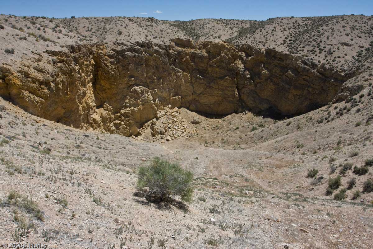
Hole-in-the-ground sinkhole, Millard County, Utah. Photograph by Shaan Hurley (Flickr; Creative Commons Attribution 2.0 Generic license; image resized).
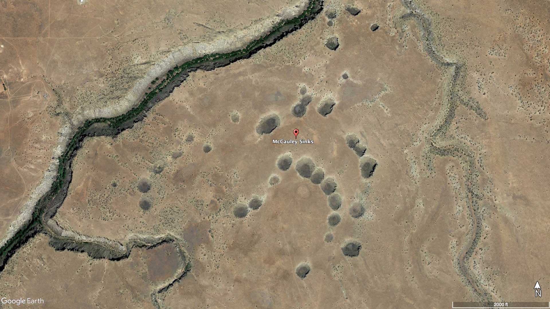
Satellite image of the McCAuley Sinks, a series of aligned sinkholes in the Permian Kaibab Formation near Winslow, Arizona. Image by Google Earth.
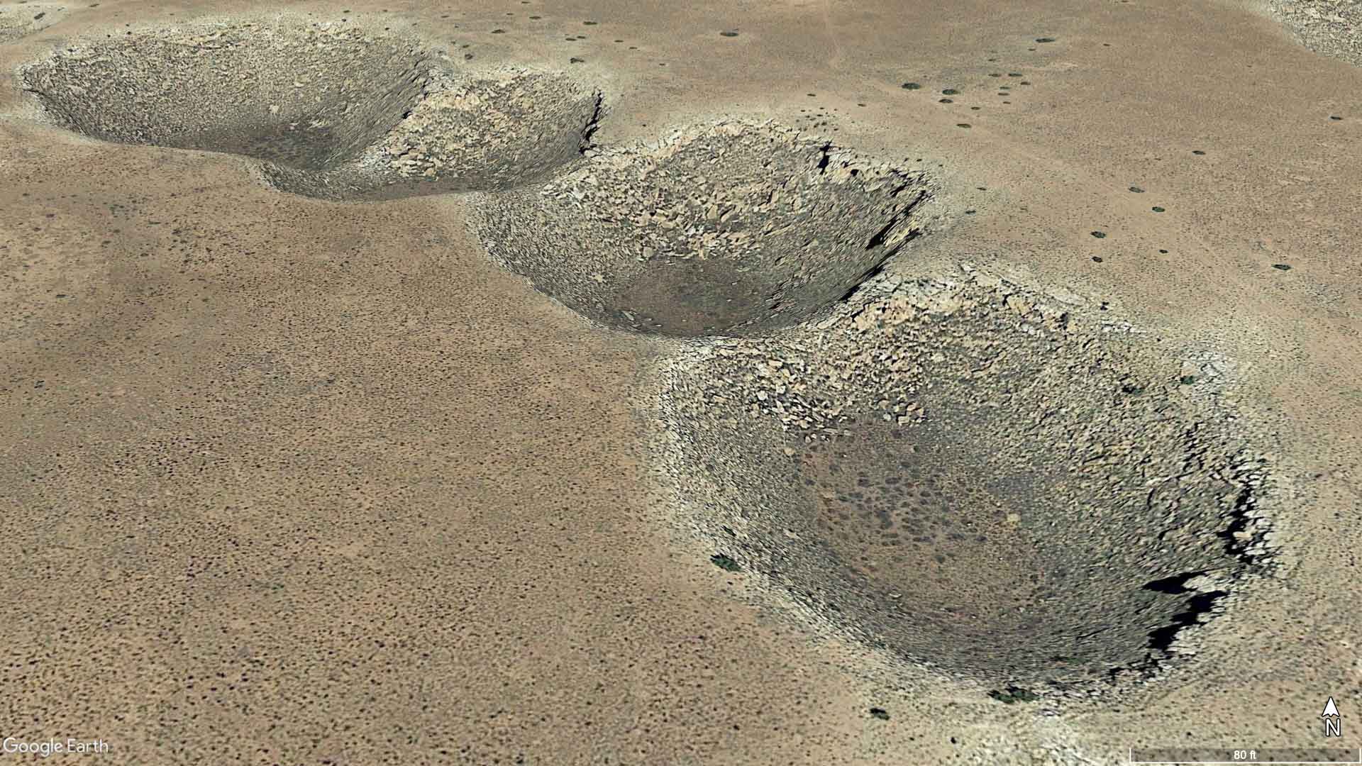
Close-up satellite image of the McCAuley Sinks, a series of aligned sinkholes in the Permian Kaibab Formation near Winslow, Arizona. Image by Google Earth.
Sinkholes can form by several different mechanisms, but all require dissolution of rock beneath the surface. Manmade sinkholes can also occur through the collapse of mine shafts and tunnels, or the removal of groundwater and oil. Sinkhole formation commonly damages roads, buildings, and utilities, and it is a problem in all four Southwestern states. A sinkhole near Carlsbad, New Mexico is endangering the town of Carlsbad, New Mexico; work is underway to address the threat.
"Could this sinkhole threaten entire town?" (Carlsbad, New Mexico) by CNN (YouTube).
Asbestos
While many people worry about the asbestos insulation hazards found in older buildings, few consider the hazards associated with the minerals’ natural occurrence. Natural asbestos sources can be found throughout the Southwest, and it has been mined in both Utah and Arizona, though these mines are no longer in operation thanks to recent limitations placed on the minerals’ use. Remediation attempts on abandoned mines include blocking off access to contaminated areas and burying contaminated soil that has been found near surface water sources.
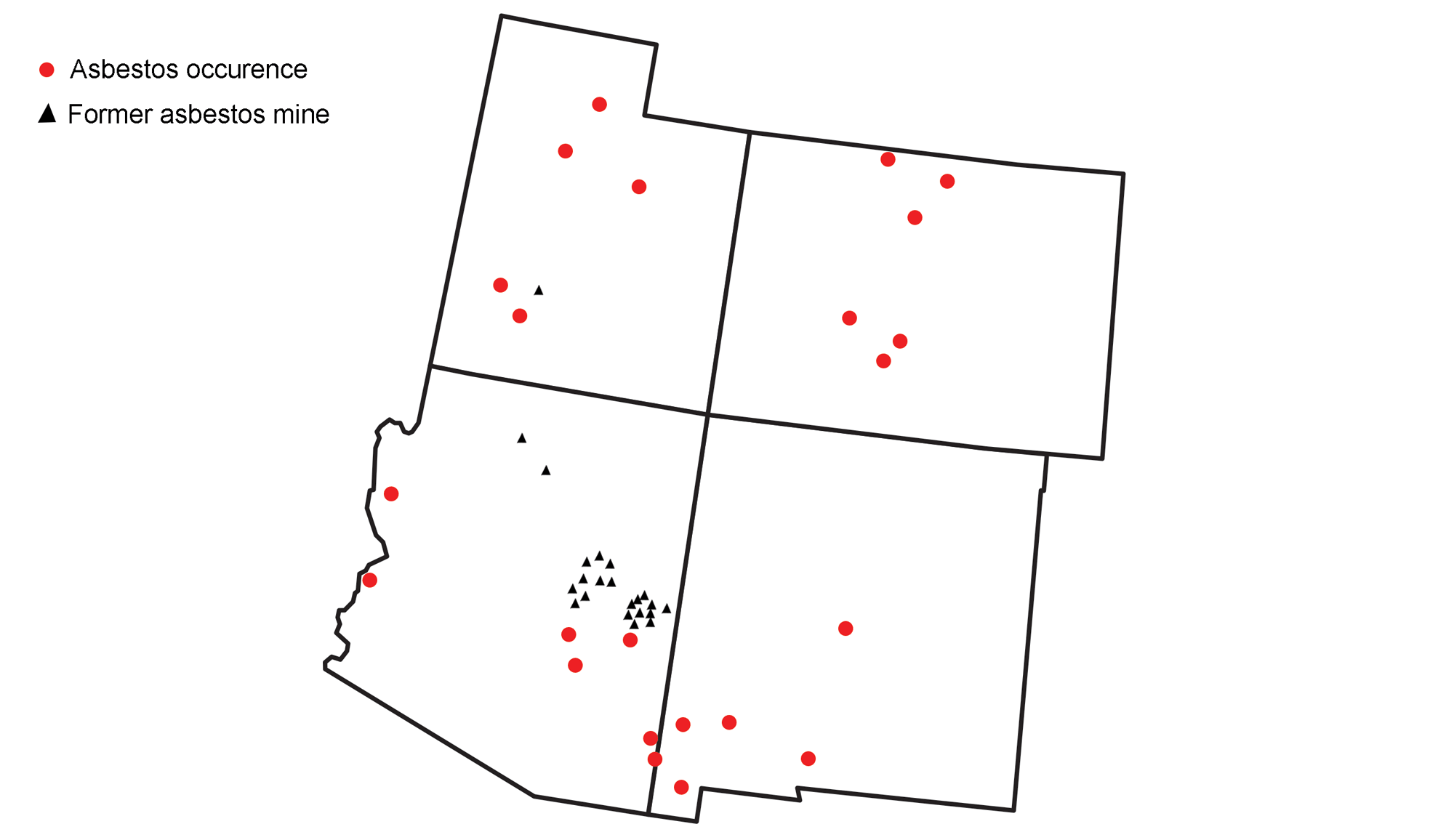
Presence of significant asbestos sources and former mines in the southwestern United States. Image by Wade Greenberg-Brand, adapted from image by USGS (public domain) and modified for the Earth@Home project.
Radon
Although radon is more or less universally present, high levels of radon are associated with areas containing uranium-rich bedrock. Most rocks have a small amount of uranium, but certain rocks tend to have higher concentrations of the radioactive element, such as light-colored volcanic rocks, granites, dark shales, sedimentary rocks with phosphates, and metamorphic rocks. Radon concentrations are generally high in the Southwest’s mountainous areas, as uranium is relatively concentrated in the granites, black shales, and metamorphic rocks of the Rocky Mountains.
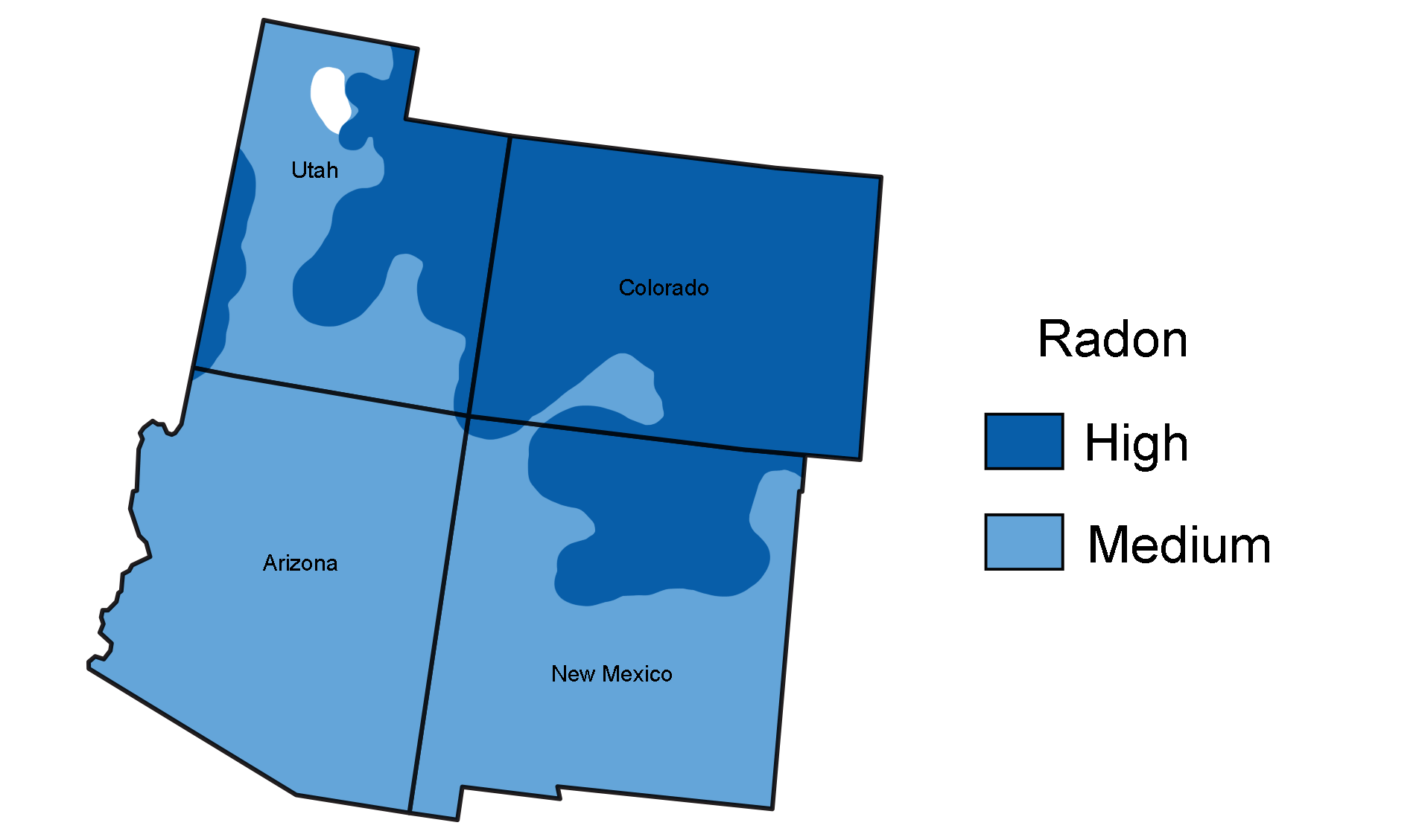
Radon risk levels at the surface in the southwestern United States. Map by Wade Greenberg-Brand, adapted from image by the EPA (public domain) and modified for the Earth@Home project.
The sediments eroded from those areas also carry a high radon hazard potential, leading to moderate radon presence throughout the Southwest.
Floods
Although the Southwest has an overall arid climate, there are several large rivers that flow through the area, including the Colorado River and Rio Grande. Many of the Southwest’s largest floods have occurred along the Colorado River and its tributaries.
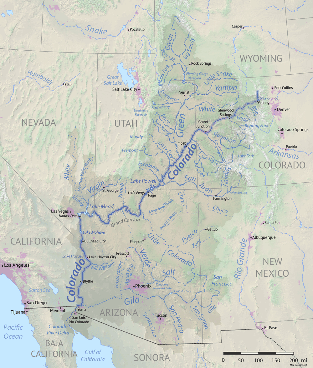
The Colorado River and its tributaries. Image by "Shanon1" (Wikimedia Commons; Creative Commons Attribution-ShareAlike 4.0 International license; image resized).
Along floodplains, the soil is fertile thanks to nutrients deposited by the rivers, and nearby water allows for easy irrigation. These factors encourage development on flood-prone areas throughout the Southwest. In the Great Plains, a large proportion of farmland—a significant industry in the Southwest—is located on floodplains along rivers that flow through the region.
In the Southwest, arid air travelling from the western mountains draws in moisture from the south where there are no mountains to block the moisture, a phenomenon known as a monsoon climate. Warm, moist air has a concentration of energy that may be released in sudden, violent thunderstorms, generating downpours that lead to flash floods. Monsoon floods occur in every Southwestern state, and can reach heights of 9 meters (30 feet) or more, moving rocks and trees, sweeping away vehicles, and destroying buildings.
"Hatch [New Mexico] Still Recovering From 2006 Flood" by KVIA.com (YouTube).
Flash floods in the Southwest also tend to be especially deadly and destructive due to the area’s many canyons, which funnel water to great speeds and depths. In September 2015, extreme rainfall generated by Pacific Hurricane Linda flooded Keyhole Canyon in Zion National Park, Utah. In only 15 minutes, the Virgin River’s flow increased from 1.5 cubic meters (55 cubic feet) per second to 74.5 cubic meters (2630 cubic feet) per second. Seven hikers were swept away and killed. Near Hildale, Utah, rainfall from the same event caused major flash floods that swept away vehicles, killing 13 people, as well as destroying water lines, bridges, and power infrastructure for the town.
"'Everything is Gone': Flash Flood Devastate Utah-Arizona Border Towns | NBC Nightly News" by NBC News (YouTube).
Floods can occur at any time, but major floods are more frequent in spring and fall after periods of heavy or sustained rains when stream levels rise rapidly. For example, rapid runoff from distant storms in the Rocky Mountains has had devastating effects, both in the mountains and where streams spread over broad areas of more open land. These floods have damaged structures, property, and put lives in peril. For example, in September 2013, torrential rains over Colorado’s Front Range resulted in catastrophic flooding along the South Platte River and related tributaries. Up to 510 millimeters (20 inches) of rain fell over a three-day period; water levels of the river reached as high as 2.7 meters (8.8 feet) above flood level and affected 17 counties.
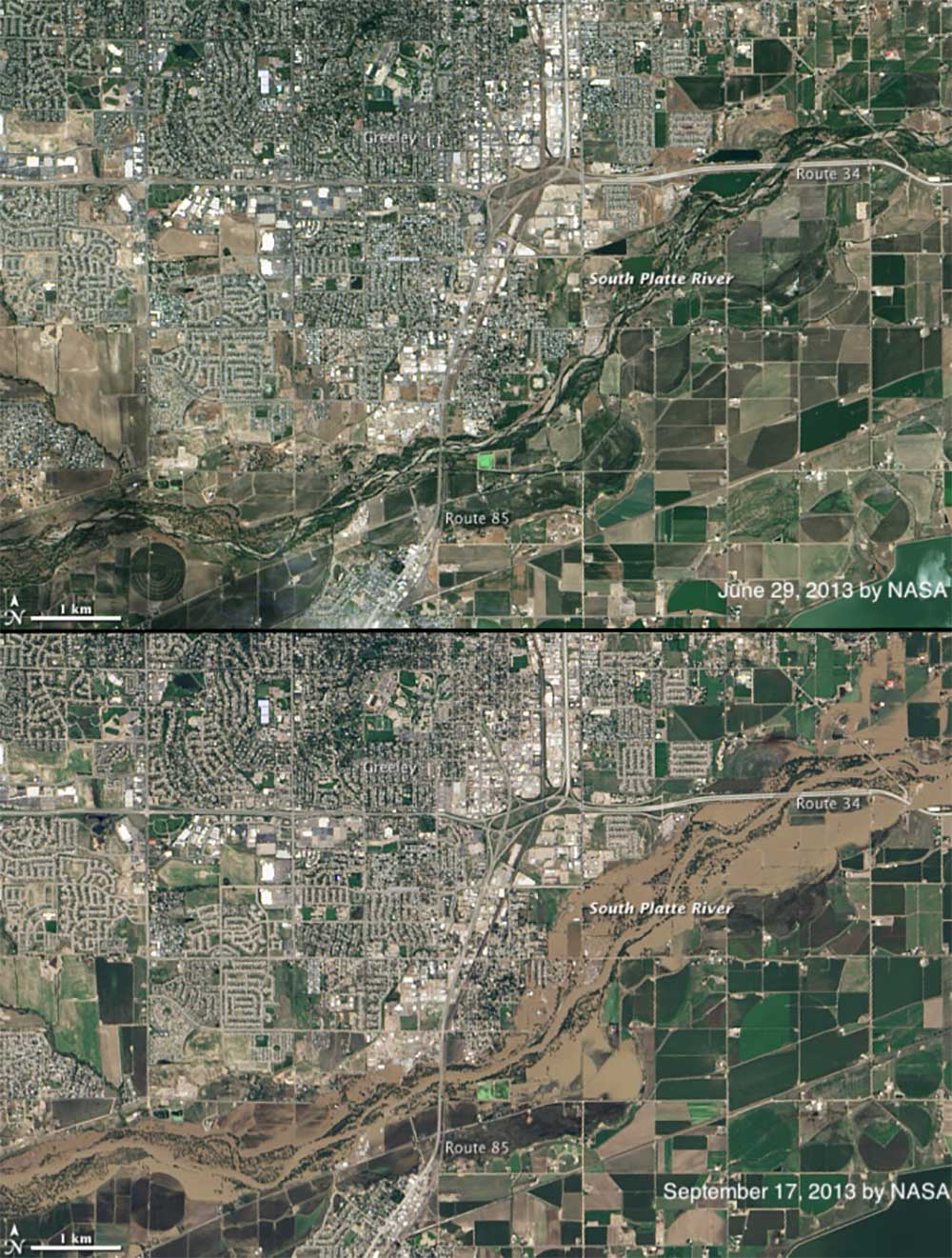
Before (top) and after (bottom) images of the South Platte River flood near Greely, Colorado, in September 2013. Images by NASA (public domain).
Weather hazards
Weather is the measure of short-term atmospheric conditions such as temperature, wind speed, and humidity. The Southwest is an active location for atmospheric events such as thunderstorms and tornados. It also experiences a variety of other weather hazards, including high temperatures and drought.
Storms and tornados
Several types of severe storms present challenges to people living in the Southwest. Summer brings severe thunderstorms associated with cold fronts. Fall and spring can bring ice storms, while winter brings snow and, in some cases, blizzard conditions. In March 2016, for example, a major blizzard dumped 60 centimeters (2 feet) of snow on the Denver metropolitan area and Colorado’s Front Range, knocking out power, shutting down the Denver International Airport, and closing schools. A second event in April 2016—dubbed Winter Storm Vexo—inundated the Southwest with more heavy snowfall, from 1.3 meters (51 inches) in Pinecliffe, Colorado to 28 centimeters (11 inches) near Questa, New Mexico and 18 centimeters (7 inches) in Bellemont, Arizona.
Rainstorms occur where colder air from higher latitudes abruptly meets warmer air. Severe thunderstorms are a common occurrence for people living in the eastern Southwest because the conditions over the Great Plains are perfect for the development of severe weather. The region’s flat, open fields are warmed by the summer sun, which sits high in the sky during this time of year. This results in large temperature differences when cold air masses move across the country, leading to rainstorms.
“Tornado Alley” is the nickname for an area, extending from Texas to Minnesota, that experiences a high number of exceptionally strong tornados due to its flatter topography and high incidence of severe thunderstorms. The Great Plains of Colorado and New Mexico are part of Tornado Alley, leading to more tornados in this part of the Southwest. From 1991 to 2010, for example, an annual average of 53 and 11 tornados occurred in Colorado and New Mexico, respectively.
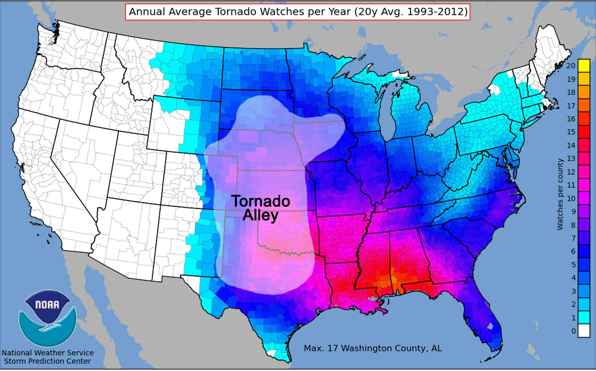
Average yearly tornado watches in each county of the United States between 1993 and 2012. Tornado Alley is identified. Map by NOAA (public domain) modified for the Earth@Home project.
To the west, fewer tornado strikes occur, with an annual average of five and three striking Arizona and Utah, respectively. The boundaries of Tornado Alley vary in application, depending on whether the frequency, intensity, or number of events per location are used to determine its borders.
Dust storms
In arid climates, even under non-drought conditions, dust storms are a hazard. Dust storms occur when winds hold dust aloft, sometimes briefly over a local area, and sometimes over broad regions for days. They can be hazardous to health and, because they drastically reduce visibility, dangerous to motor vehicle and airline traffic.
Among the most spectacular dust storms are those known as haboobs (or monsoonal dust storms), which occur when strong thunderstorm downdrafts blow loose sediments up from the desert, sending dust up to over 1000 meters (3300 feet) into the sky. Large haboobs can be as much as 100 kilometers (62 miles) across, and travel at speeds of 50 to 100 kilometers per hour (about 30 to 60 miles per hour) for over an hour. These storms occur in the summer, across southernmost New Mexico and Arizona, as well as in California and Texas.
"What is a Haboob" by WeatherNation (YouTube).
In addition to the inhalation of silt and clay dust, other health hazards associated with dust storms include fungi, bacteria, pollutants, and heavy metals. These materials can irritate the lungs and trigger asthma attacks, allergic reactions, and other illnesses. One fungus, Coccidioides, causes "valley fever," which causes cold- and flu-like symptoms and sometimes rashes. Though most recover without treatment, it can have serious consequences and even lead to death for some people with weak immune systems.
Extreme Temperature and Drought
Extreme temperatures can create dangerous conditions for people and may lead to property damage. Summer temperatures in the arid Southwest can reach dangerously high levels, and temperatures around or above 38°C (100°F) are not uncommon. High heat can lead to a series of health complications if not properly dealt with—heat exhaustion, heat stroke, and dehydration can all result from exposure to extreme temperatures. Since the human body can only survive a few days (typically three) in the desert without water, a stranded and unlucky hiker or camper can easily die of dehydration if a suitable water supply cannot be reached in time. Heat waves are periods of excessively hot weather that may also accompany high humidity. Temperatures of just 3°C (6°F) to 6°C (11°F) above normal are enough to reclassify a warm period as a heat wave. Under these conditions, the mechanism of sweating does little to cool people down because the humidity prevents sweat from evaporating and cooling off the skin. Heat waves have different impacts on rural and urban settings. In rural settings, agriculture and livestock can be greatly affected. Heat stress recommendations are issued to help farmers protect their animals, particularly pigs and poultry, which, unlike cattle, do not have sweat glands.
The impacts of heat waves on urban settings include a combination of the natural conditions of excessive heat and the social conditions of living in a densely populated space. Cities contain a considerable amount of pavement, which absorbs and gives off more heat than vegetation-covered land does. Air conditioning units that cool down the inside of buildings produce heat that is released outside. Pollution from cars and industry also serve to elevate the outdoor temperatures in cities. This phenomenon, in which cities experience higher temperatures than surrounding rural communities do, is known as the heat island effect.
Other social conditions can increase the hazards associated with heat waves in urban areas. People who are in poor health, live in apartment buildings with no air conditioning, or are unable to leave their houses are at greatest risk of death during heat waves. 2020 was the hottest year on record in Phoenix, Arizona, which had 53 days that reached temperatures of 110°F or higher. The video below describes how Phoenix is trying to manage this extreme heat.
"How America's Hottest City is Innovating to Survive | Weathered" by PBS Terra (YouTube).
While high temperatures can be directly dangerous, a larger scale hazard arises when these temperatures are coupled with lack of precipitation in an extended drought period. The Southwest has experienced both short-term and even decade-long periods of drought. Unlike other hazards, drought sets in slowly and takes time to be recognized. Agricultural areas can be seriously affected by a lack of rainfall and insufficient water supplies. Even higher-altitude forests show signs of stress since the combination of heat and long-term lack of precipitation deprives the land of one of its key resources. Lack of precipitation does not simply mean a lack of rain—it also means less seasonal snowfall in the mountains. Relatively little mountain snow in the winter translates into a lack of water for crop irrigation and household use in desert portions of the Southwest. Change in the flow rate of the Colorado River, which originates in the Rocky Mountains, serves as an excellent diagnostic for the effects of drought. This river is crucial for the irrigation of crops, and it feeds manmade reservoirs such as Lake Powell that supply drinking water to much of the region. An additional concern is that record low water levels in Lake Powell may affect the ability of the Glen Canyon Dam near Page, Arizona to produce hydroelectric power.
Many significant droughts have occurred in the southwestern states—one notable instance of catastrophic drought in the Southwest was the Dust Bowl of the 1930s. Severe drought led to a drying of much of the topsoil, which was crucial to the agriculture of the area. High winds stripped the land of this topsoil, making crop growth impossible. This, in turn, led to the collapse of the farming industry, which was one of the main factors contributing to the Great Depression.
Compiled tree-ring records over the past several thousand years shows that there have been past “megadroughts” that have been worse, and lasted longer, than recent ones. Models suggest that the likelihood of such droughts is expected to increase due to the effects and continuing patterns of climate change. Recent research using both models and data suggests that the climate of the Southwestern US has become and will remain drier, as subtropical dry zones move north. Careful planning for seasonal drought, as well as extended drought, is the most effective way to reduce the chance of storage depletion in the Southwest. Conservation must be implemented as a series of progressive steps to be taken as water becomes scarcer. Out of necessity, the Southwest actually implements some of the most effective water management strategies in the United States. Still, no amount of planning can eliminate the long-term threat of drought, especially in an area dominated by deserts and under threat of the influence of changing climate.
Climate change
It is important to understand that most of the extreme climate change in Earth’s history occurred before humans existed. That being said, the rapid release of carbon dioxide into the atmosphere from human activity is currently causing a global warming event. The seemingly slight increase in the average annual temperatures in the Southwest over the past 25 years has been accompanied by more frequent heat waves, shorter winters, and an increased likelihood of drought and wildfires.
Although wildfires can occur during any season, summer fires are the most common, since increased dryness contributes to fire risk. Today these most often start due to human activities, such as a poorly extinguished campfire, but they can also occur by natural ignition from lightning. Hundreds of square kilometers (miles) of forest have been lost to wildfires despite our best efforts to prevent, control, and extinguish them. Rural towns and summer homes, along with the people who inhabit them, can be suddenly caught in the blaze. Not only do these fires spread quickly, but human attempts to extinguish the blaze are hindered by the lack of available water to fight the fire.
Water supply is also a critical issue for the Southwestern states. Here, most water is obtained from precipitation, snowmelt, and runoff, which will dramatically decrease in quantity as temperature and aridity rise. In addition, parts of Colorado and New Mexico obtain agricultural and drinking water from the Ogalalla aquifer, an underground layer of water-bearing permeable rock. Part of the High Plains aquifer system, this underground reservoir supplies vast quantities of groundwater to the Great Plains. As drought intensifies and temperature rises, the amount of water drawn from the aquifer (especially for agricultural irrigation) has increased, while the rate at which the aquifer recharges has decreased. The aquifer’s average water level has dropped by about 4 meters (13 feet) since 1950, and in some areas of heavy use, the decrease is as high as 76 meters (250 feet).
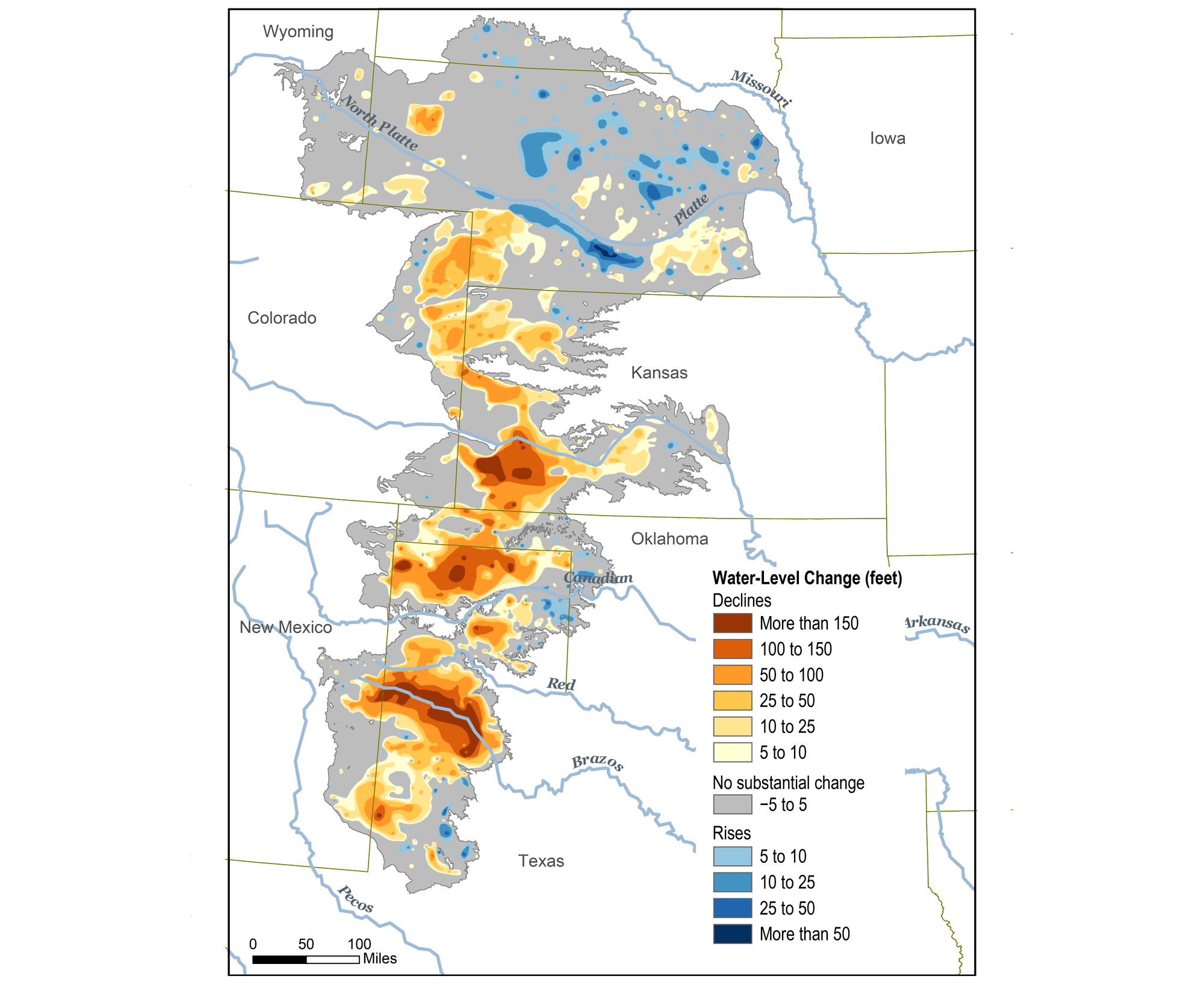
Original caption: "This map shows changes in Ogallala water levels from before the aquifer was tapped to 2015. Declining levels are red or orange, and rising levels are blue." Map from Climate.gov (NOAA).
However, the aquifer only replenishes at a rate no greater than 150 millimeters (6 inches) per year. Some estimates indicate that at its current rate of use, the entire Ogalalla aquifer could be depleted by as early as 2028, threatening human lives, our food supply, and the entire Great Plains ecosystem.
In rural desert and semi-desert areas that are not served by well-planned regional or municipal systems, most people are dependent upon streams and wells. Streams often run dry, especially in the summer. The water table (the level of underground water) then migrates deeper, forcing people to extend wells deeper into the ground. Unfortunately, this is only a temporary solution.
In most of these areas, water is being withdrawn much more quickly than it is naturally replenished. Another hazard arising from excessive pumping of groundwater in the Southwest is land subsidence and subsidence-related earth fissures. In sum, lack of water reserves can lead to a cycle of economic disasters as well as the displacement of populations and businesses. The preservation and storing of water in large aquifers (water banking) for future use is an important technique to help adapt to drought.
Increasing temperatures also allow certain pests, such as ticks and mosquitoes, to live longer, thereby increasing the risk of contracting the diseases they carry. In addition, organisms that damage ecosystems, such as the bark beetle, are better able to survive warmer winters, thrive, and multiply. In recent decades, bark beetles are estimated to have affected more than twice the forest area burnt by wildfires in New Mexico and Arizona.
Another concern regarding hazards exacerbated by climate change in the Southwest is whether or not there has been or will be an increase in the number or severity of storms, such as hurricanes and tornados. According to NASA, the present data is inconclusive in terms of whether hurricanes are already more severe, but there is a greater than 66% chance that global warming will cause more intense hurricanes in the 21st century. Since climate is a measure of weather averaged over decades, it might take many years to determine that a change has occurred with respect to these types of storms. Scientists are certain that the conditions necessary to form such storms are becoming more favorable due to global warming.