

Spotlight: Overview of the rocks of the Basin and Range region of the southwestern United States, including New Mexico, Arizona, and Utah.
Topics covered on this page: Overview; Precambrian; Paleozoic; Mesozoic; Cenozoic; Resources.
Credits: Most of the text of this page is derived from "Rocks of the Southwestern US" by Lisa R. Fisher and Richard A. Kissel, chapter 2 in The Teacher-Friendly Guide to the Earth Science of the Southwestern US (published in 2016 by The Paleontological Research Institution. The book was adapted for Earth@Home web by Elizabeth J. Hermsen and Jonathan R. Hendricks in 2022. Changes include formatting and revisions to the text and images. Credits for individual images are given in figure captions.
Updates: Page last updated March 10, 2022.
Image above: Mt. Belknap, Marysvale Volcanic Field, Utah. Photo by Bryant Olsen (flickr, Creative Commons Attribution-NonCommercial 2.0 Generic license, image cropped and resized).
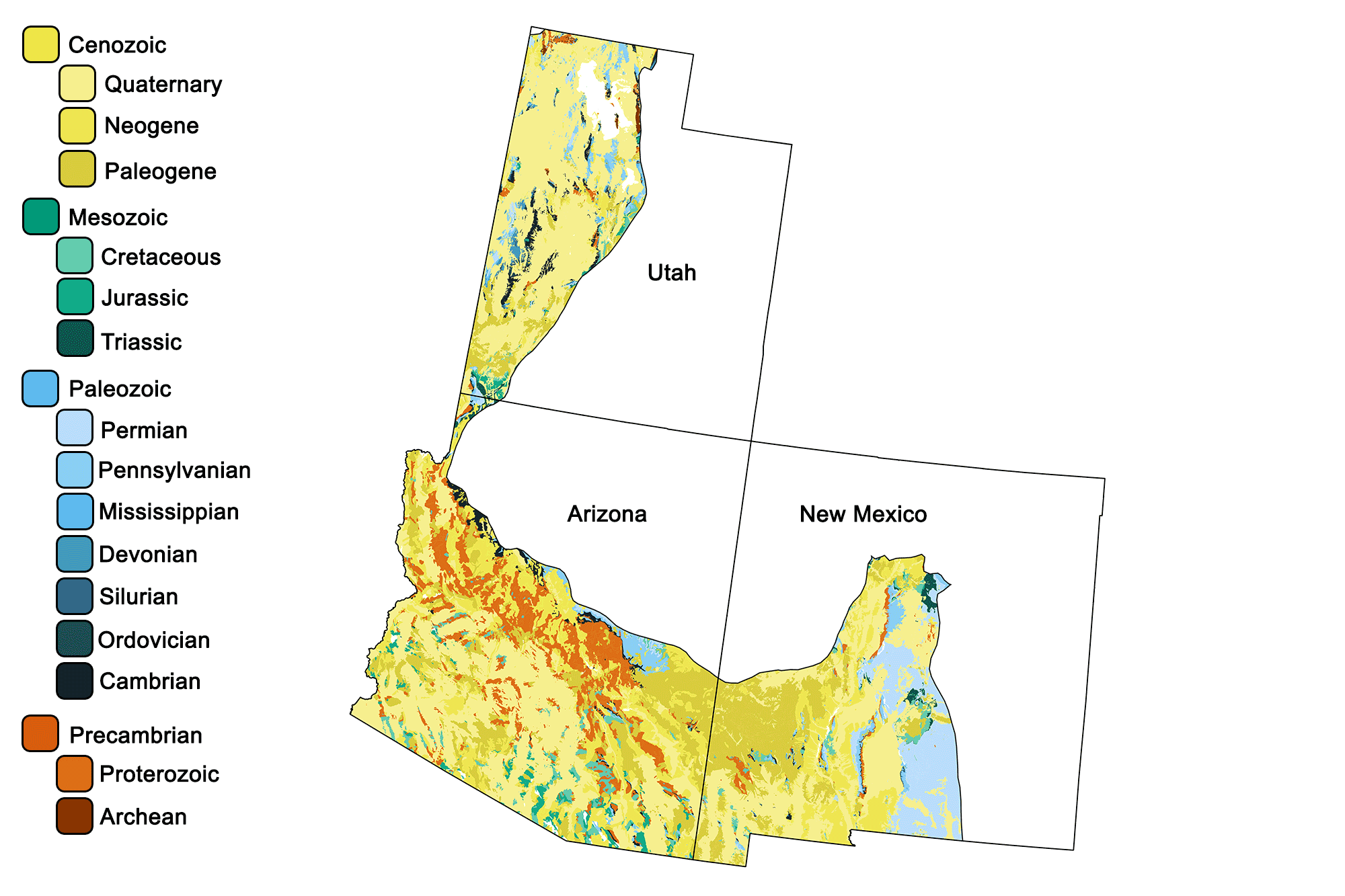
Geologic map of the Basin and Range region of the southwestern United States showing maximum ages of mappable units. Image by Jonathan R. Hendricks for the Earth@Home project developed using QGIS and USGS data (public domain) from Fenneman and Johnson (1946)and Horton et al. (2017).
Overview
A portion of the Basin and Range—a huge physiographic region that extends from southeastern Oregon to west-central Mexico—extends into the Southwest, covering most of western Utah, much of Arizona, and large areas of New Mexico. While the formation of the Basin and Range is a recent event that began only 30 million years ago, the bedrock that makes up the region’s upthrust ranges and down-dropped basins is very old. Here, rocks can be found from nearly all periods of the Phanerozoic. This is largely because the region’s most recent geologic activity involved crustal extension that has exposed many deeper, older layers.
During the Paleogene, magma upwelling from the mantle weakened the lithosphere, lowering its density. This stimulated uplift, stretching the bedrock in an east-west direction. The crust along the Basin and Range stretched, thinned, and faulted into some 400 separate mountain blocks. Movement along the faults led to a series of elongated peaks and down-dropped valleys, also called horst and graben landscapes. In a manner similar to books toppling when a bookend is removed from a shelf, the blocks slid against each other as they filled the increased space.
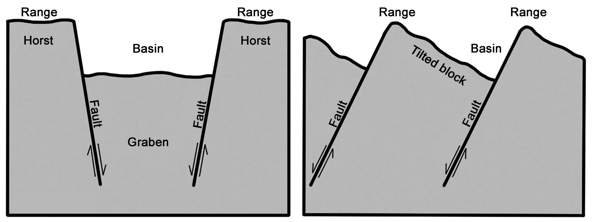
Alternating basins and ranges were formed during the past 17 million years by gradual movement along faults. Arrows indicate the relative movement of rocks on either side of a fault. Image modified from original by Wade Greenberg-Brand, in turn adapted from an image by the USGS (public domain).
Precambrian
The Basin and Range is characterized by mostly north-south oriented linear mountain ranges of Precambrian, Paleozoic, and Mesozoic-aged rocks. Since the region’s formation, the bedrock of the basins has been covered by young deposits, including loose sediment washed down from the mountains and evaporite deposits left behind in dried-out lakes. The ranges, however, expose far older materials.
The region is underlain by Precambrian basement—granitic gneisses and metamorphosed volcanic and sedimentary rocks ranging from 2.5 to 1 billion years in age. The oldest rocks in the Southwest underlie the northern part of Utah, as well as southwestern Utah and northwestern Arizona. Exposures of these rocks are rare, occuring in the cores of uplifted ranges.
Most of the Precambrian rocks exposed in the Basin and Range are related to the Grand Canyon Supergroup, produced approximately 1.2 to 1.1 billion years ago during formation of the supercontinent Rodinia. The mildly metamorphosed conglomerate, sandstone, shale, and dolomite layers of the Grand Canyon Supergroup are exposed in the Cricket Mountains of west-central Utah. In addition, ancient tillites (glacial deposits) found in Utah represent major glaciation events that occurred during the Proterozoic.
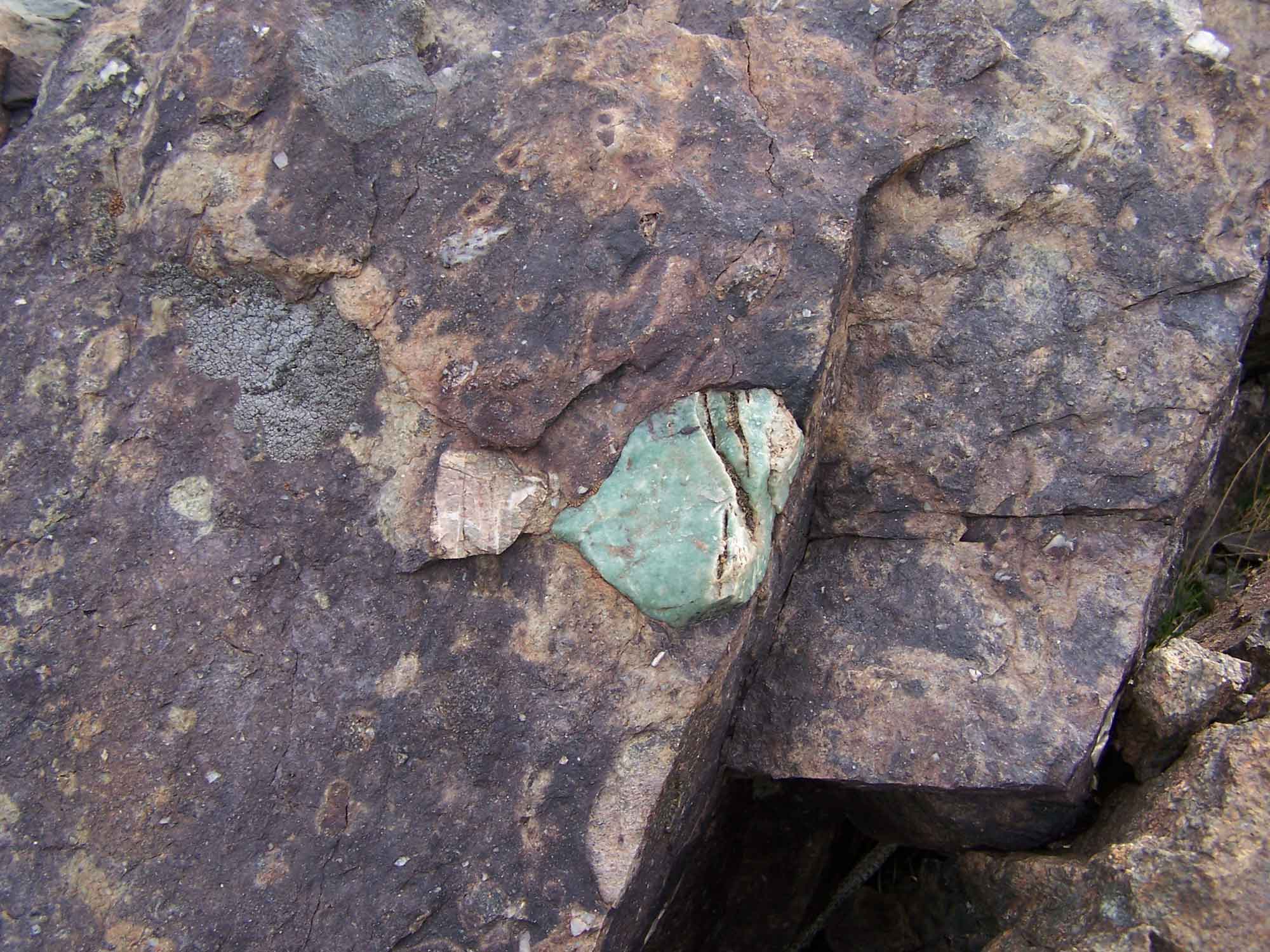
A piece of the Mineral Fork Tillite from Antelope Island, Utah. This rock is thought to have been deposited during the “Snowball Earth” Proterozoic glacial period, and is composed of glacial alluvium as well as embedded aventurine quartz. Photograph by Bryant Olsen (Flickr; Creative Commons Attribution-NonCommerical 2.0 Generic license; image resized).
Paleozoic
The Basin and Range’s Paleozoic rocks—a succession of sandstones, limestones, and shales—were deposited on the western shore of North America from the Cambrian to the Mississippian. These rocks, like those in the Colorado Plateau, record a story of rising seas and shallow marine environments. Early Ordovician limestones of the El Paso Formation extend from southern Arizona and New Mexico into western Texas; Utah hosts similar limestones, sandstones, and dolomites, with occasional conglomerates formed when tidal currents ripped up newly deposited carbonate layers.
This was followed during the Pennsylvanian through the Permian by a transition to shallow and evaporating seas, which deposited sandstones, mudstones, limestones, and phosphate-rich rocks. Thick Pennsylvanian sedimentary sequences are present in the Oquirrh Mountains west of Salt Lake City, and in the Sacramento, Robledo, Caballo, and San Andres mountain ranges along the Rio Grande Rift. After the Permian, as receding seas left the continent high and dry, subaerial weathering caused karstic topography to develop in the exposed carbonate rocks.
Massive reefs became ideal structures for the formation of caves thanks to their permeability and soluble nature, allowing groundwater to infiltrate, dissolve, and carry away the calcium carbonate material. The Guadalupe Mountains of southeastern New Mexico expose an enormous Paleozoic reef, the Capitan Reef, which was revealed to the elements during the Permian. Carlsbad Caverns, also in the same area, is a massive limestone cave that developed in the region’s carbonate bedrock after the mountains were uplifted.
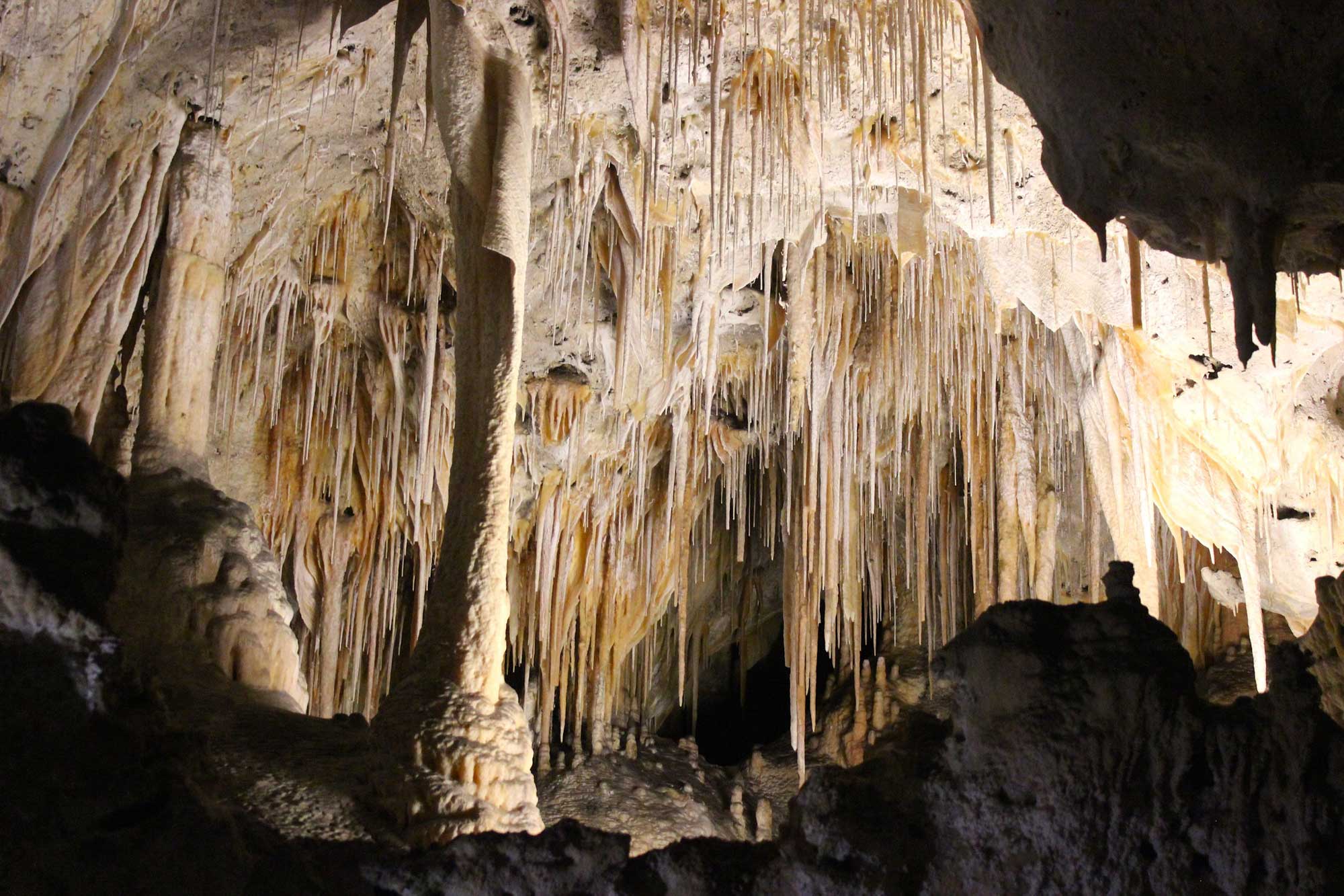
Delicate limestone speleothems decorate Carlsbad Caverns, New Mexico, in an array of spectacular formations. Photograph by "Jessica D" (Flickr; Creative Commons Attribution-NonCommercial-ShareAlike 2.0 Generic license).
Mesozoic
Mesozoic rocks in the Basin and Range are represented by the red beds, sandstones, mudstones, and limestones of the Moenkopi Formation and the Navajo Sandstone, which formed as sea level dropped relative to the land. These Paleozoic and Mesozoic sediments form the cores of the region’s mountain ranges; they were thrusted during the Sevier Orogeny, then involved in the Basin and Range style of extension during the Paleogene. Valleys and basins formed by this extensional faulting were filled with younger rocks from the Cretaceous and the Cenozoic.
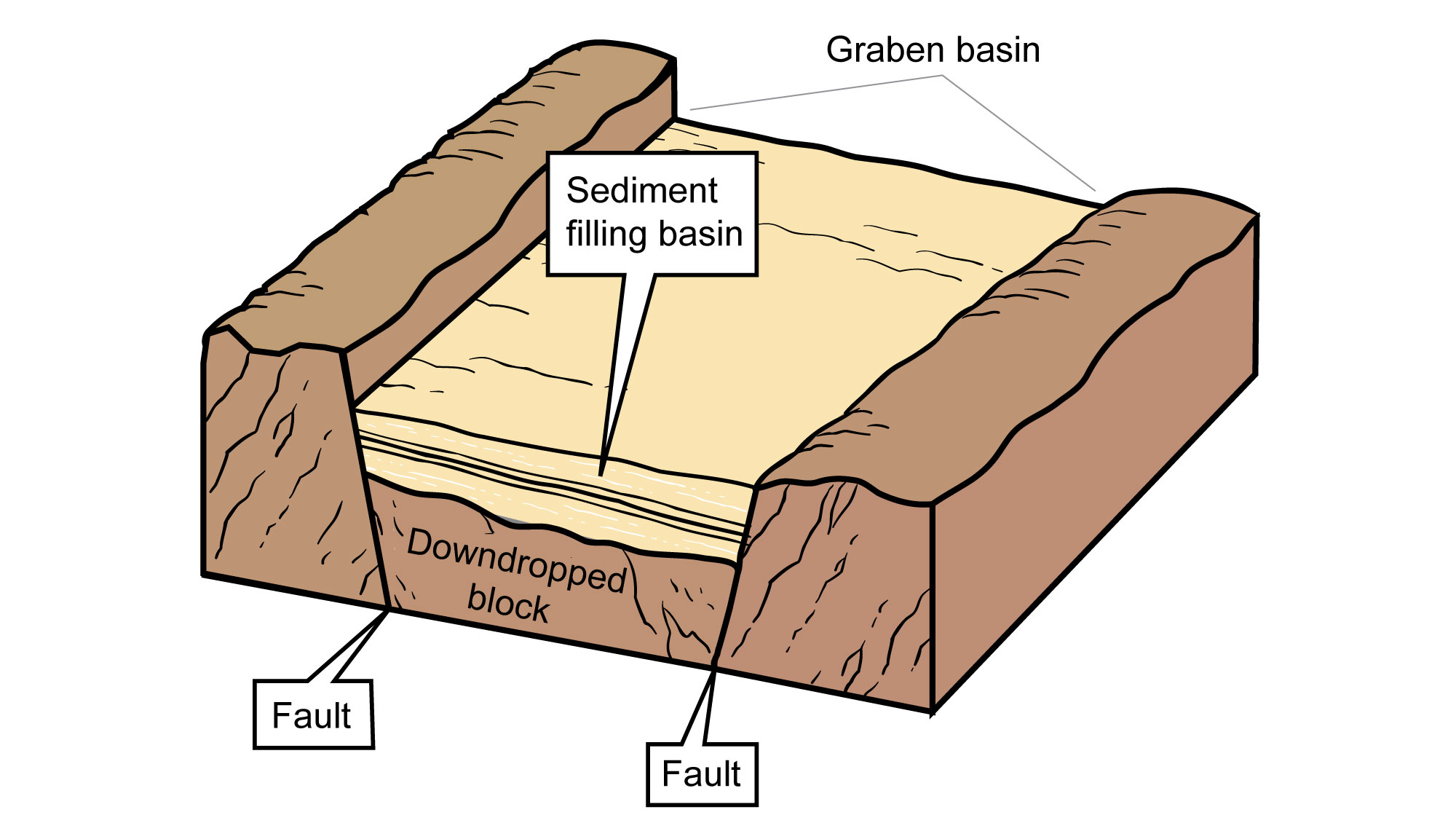
Basin fill in the Basin and Range. Image modified from original by Jim Houghton.
These rocks are mainly conglomerates, sand-stones, and mudstones originating from erosion of the nearby uplifts. Neogene sediments from glacial lakes, modern streams, and volcanic activity are also common.
Cenozoic
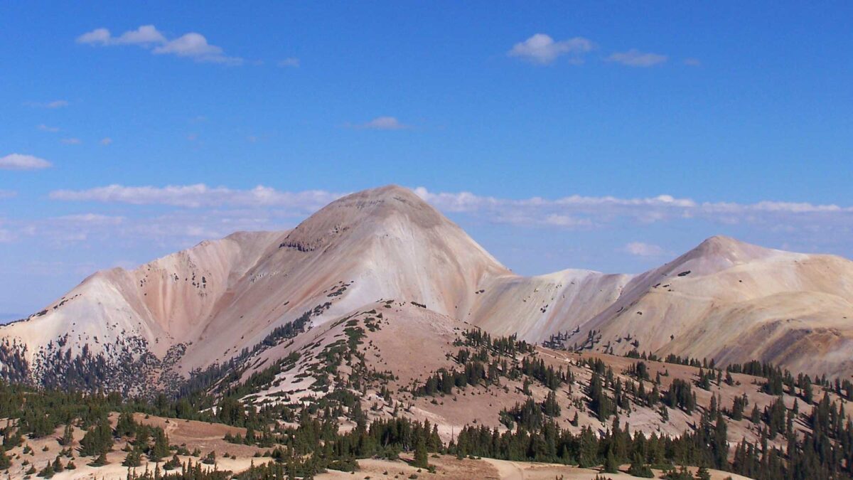
During the Cenozoic, the Southwest experienced significant active volcanism and plutonism. The Paleogene saw magma well up from the mantle from approximately 50 to 45 million years ago, intruding into the existing rock layers. By approximately 35 million years ago, upwelling intensified and the mantle began to uplift the crust, effectively tearing it and causing it to fracture and fault at the surface. This process formed a rugged landscape, created numerous igneous intrusions, and fed the region’s volcanoes. The partial melting of deeper crust produced large volumes of magma that was both emplaced in the crust and erupted on the surface (for example, plutonic granite and volcanic rhyolite). Many of these rocks host mineral deposits, ranging from precious metals to uranium to industrial materials such as perlite. Most of the Southwest’s larger volcanic fields can be found within the Basin and Range, especially around the region’s border with the Colorado Plateau.
The Marysvale Volcanic Field in western Utah is one of the largest volcanic fields in the western United States. During the Oligocene and Miocene, it and the neighboring Pioche Belt erupted large volumes of silicic magma, basalt, and ash, producing a variety of volcanic features that included cinder cones, lava domes, and calderas. The Boot Heel Volcanic Field, covering an area of more than 24,000 square kilometers (9300 square miles) across New Mexico, Arizona, and Mexico, includes nine calderas, extrusive flows (rhyolite, basalt, andesite, and tuff), and intrusive granite.
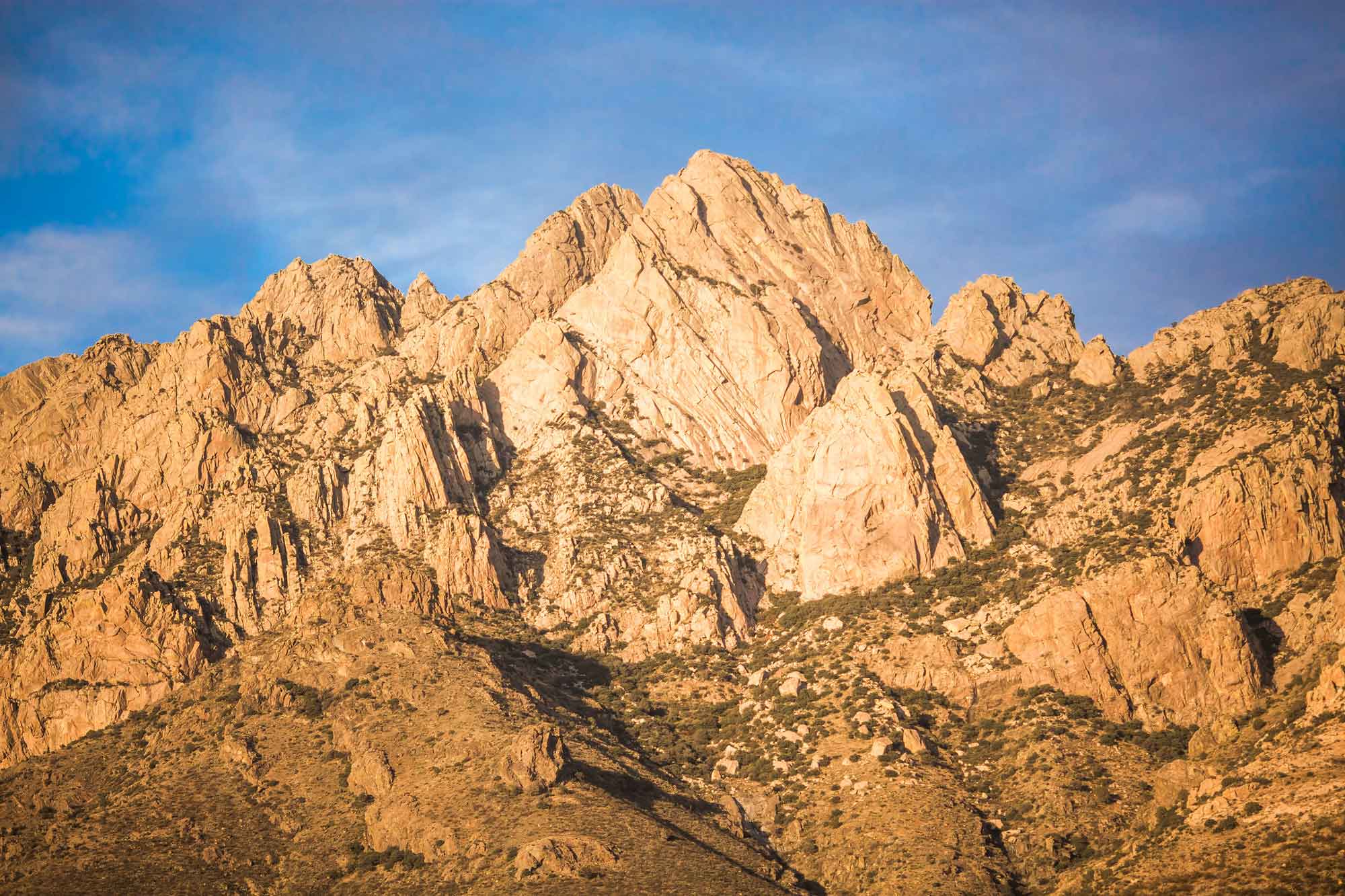
The Organ Mountains, an exposure of granite and rhyolite in New Mexico’s Boot Heel Volcanic Field. Photograph by Thomas Hawk (Flickr; Creative Commons Attribution-NonCommercial 2.0 Generic license; image resized).
The San Francisco Volcanic Field in Arizona contains the San Francisco Peaks—the eroded remnants of an enormous stratovolcano—and cinder cones such as the Sunset Crater, a 340-meter-high (1120-foot-high) cone of basaltic andesite that last erupted only 1000 years ago. Other Cenozoic volcanic fields in the Basin and Range include the Ajo (Arizona), the Black Rock Desert (Utah), and the Mogollon-Datil (New Mexico). Igneous rocks in the Basin and Range may also appear outside of volcanic fields, such as the exposures of jointed basalt found in Utah’s geologically complex Traverse Range.
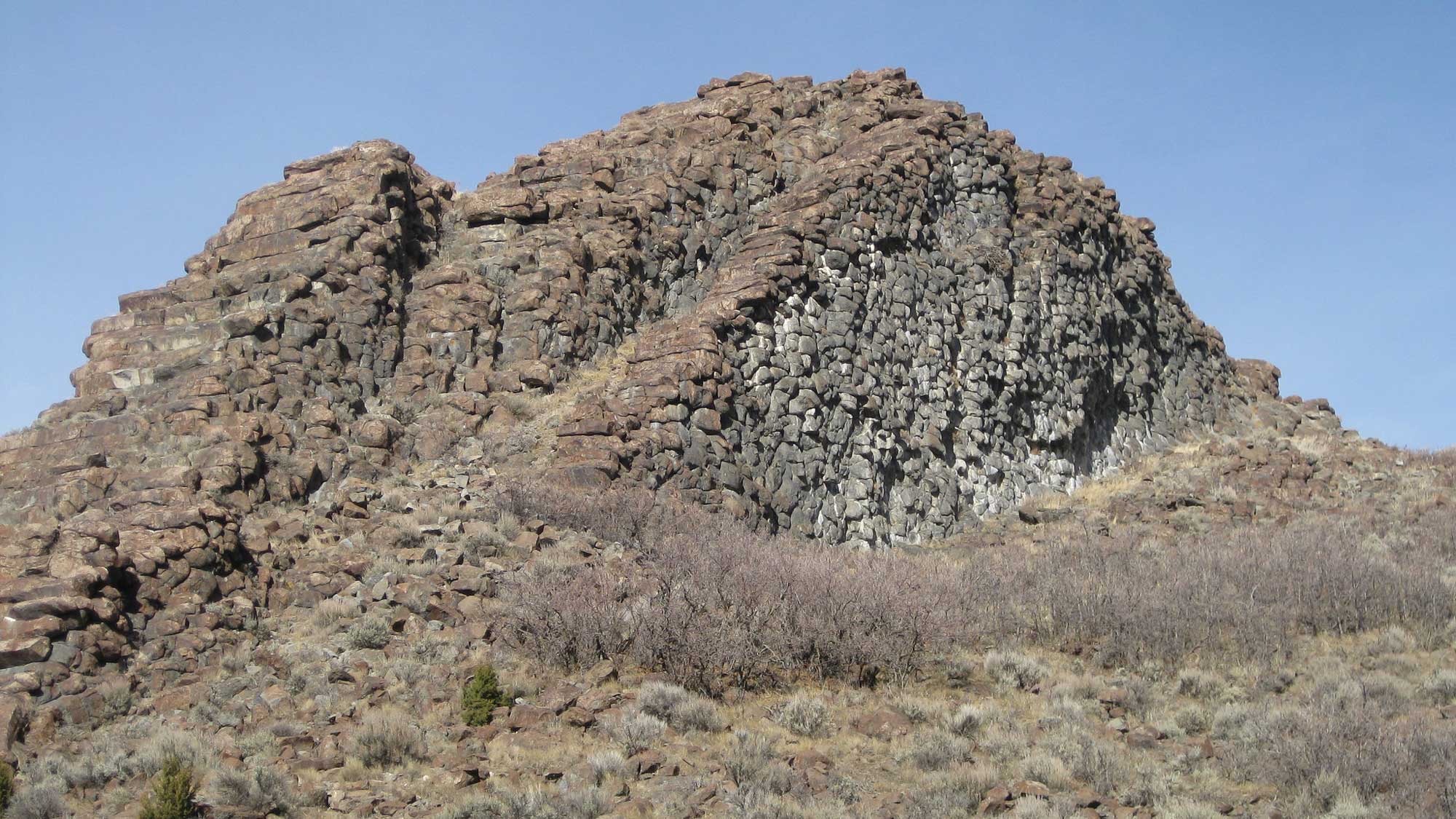
Step Mountain, in the Traverse Range, Utah, is composed of overturned basalt that exhibits columnar jointing. Photograph by Tristan Higbee (Flickr; Creative Commons Attribution 2.0 Generic license; image cropped and resized).
While limited extensional forces continued to act on the Basin and Range up until 10 million years ago, the dominant activity in the region since the beginning of the Neogene has been erosion. The region’s valleys are being filled with sediment from the surrounding mountains and mesas, creating thick deposits in northwest-southeast trending bands. Quaternary deposits in the Basin and Range are primarily composed of glacial outwash from rivers, streams, and glacial lakes. These sediments were derived from alpine glaciers in the Rocky Mountains, and were also produced by the Cordilleran Ice Sheet during the ice age. Windblown sand and dust, both Pleistocene and modern, are also common components of the region’s Quaternary deposits.
Resources
Resources from the Paleontological Research Institution
Digital Encyclopedia of Earth Science: Minerals.
Earth@Home: Introduction to Rocks.
Earth@Home: Geologic Time Scale.
Earth@Home: Geologic Maps.
Earth@Home Virtual Collection: Rocks (Virtual rock collection featuring 3D models of rock specimens sorted by type.)