

Credits
Most of the content in this chapter is derived from the climate chapters of the Teacher-Friendly Guide series for different regions of the U.S.; these chapters were written by Ingrid H.H. Zabel, Judith T. Parrish, and Don Haas, and edited by Andrielle N. Swaby, Mark D. Lucas, and Robert M. Ross (published by the Paleontological Research Institution.) The climate chapter content was adapted for the web by Elizabeth J. Hermsen, Jonathan R. Hendricks, and Ingrid H. H. Zabel in 2021 and 2022. Changes include formatting and revisions to the text and images. Credits for individual images are given in figure captions. Other content comes from "Chapter 6: U.S. Regional Climates, Present and Future" by Ingrid H. H. Zabel and Benjamin Brown-Steiner in The Teacher-Friendly Guide to Climate Change (PRI, 2017).
Chapter Contents:
- South-Central United States
- Southeast United States
- Southwest United States
- West United States, including Alaska
- Hawaii
- Northwest-Central United States
- Midwest United States
- Northeast United States
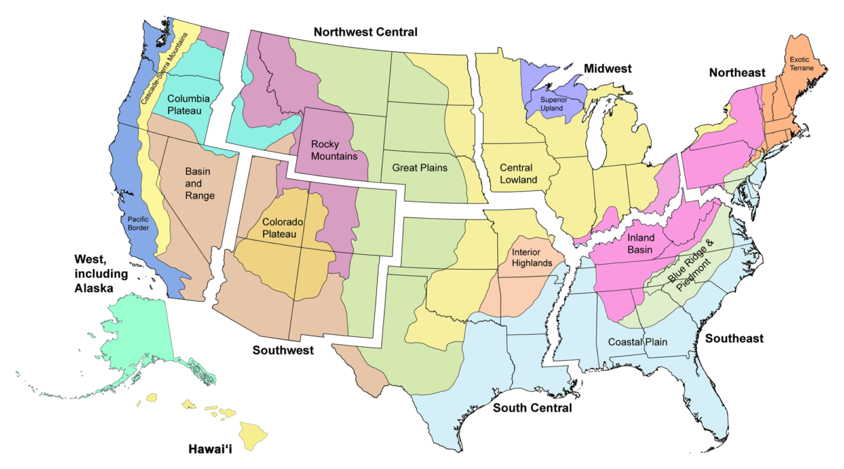
Image above: Major physiographic provinces of the contiguous United States. Note that the provinces each span multiple states and, in some cases, multiple regions. Map by Jonathan R. Hendricks.
The sections in this chapter are part of Here on Earth: Regional Guides to Earth Science for the United States. Each section provides an overview of the past, present, and projected future climate of the U.S. regions defined in Here on Earth and shown on the map above. Climate, of course, does not follow state boundaries, so the climate characteristics of the regions in this chapter can overlap with those of neighboring regions.
Climate is a description of the average temperature, range of temperatures, humidity, precipitation (rainfall and snowfall), and other atmospheric and hydrospheric conditions a region experiences over a period of many years. These factors interact with and are influenced by other parts of the Earth system, including geology, geography, insolation, currents, and living things.
Because it is founded on statistics, climate can be a difficult concept to grasp, yet concrete examples can be illuminating. Terms like "desert," "rain forest," and "tundra" describe climates, and we have gained a general understanding of their meaning. Climate can also encompass the cyclical variations a region experiences; a region with a small temperature variation between winter and summer—San Francisco, for example—has a different climate from one that has a large variation, such as Buffalo, New York. Scientists have settled on 30 years as the shortest amount of time over which climate can be defined, but it can of course also define time periods that are millions of years long.
You cannot go outside and observe climate. Weather, on the other hand, can be observed instantly. What is the temperature right now? Is it raining? Weather varies with the time of day, the season, multi-year cycles, etc., while climate encompasses those variations. Our choice of clothing in the morning is based on the weather, while the wardrobe in our closet is a reflection of climate. Due to its great variety of environments, from the boreal areas of Alaska to the subtropics of Hawai‘i and Florida, residents of the United States generally have a diverse wardrobe. The most variable climates are in the interior areas and mountains of the western contiguous U.S. These areas can vary from frigid in the winter to scorching in the summer. By contrast, coastal climates have more moderate seasonal variations.
Each of these regional climates—from the equatorial wetlands of Florida to the arid deserts of Arizona—is impacted by the changing global climate, but these impacts are and will not be uniform. Coastal communities are being affected by rising sea levels and increased storm surges, while desert communities may be facing longer and more frequent droughts and heat waves. Ski resorts in the Rocky Mountains may have to adapt to less snowfall and smaller snowpacks, while communities in the Northeast are experiencing more heavy rainfalls.