

Spotlight: Overview of the rocks of the Central Lowland region of the midwestern United States, including Minnesota, Wisconsin, Michigan, Iowa, Illinois, Indiana, and Ohio.
Topics covered on this page: Precambrian; Paleozoic; Mesozoic; Resources.
Credits: Most of the text of this page is derived from "Rocks of the Midwestern US" by Richard A. Kissel and Alex F. Wall, chapter 2 in The Teacher-Friendly Guide to the Earth Science of the Midwestern US (published in 2014 by The Paleontological Research Institution and edited by Mark D. Lucas, Robert M. Ross, and Andrielle N. Swaby). The book was adapted for Earth@Home web by Elizabeth J. Hermsen and Jonathan R. Hendricks in 2022. Changes include formatting and revisions to the text and images. Credits for individual images are given in figure captions.
Updates: Page last updated January 3, 2022.
Image above: Mostly Silurian-aged dolostone cobbles on the beach at Northport, Wisconsin. The cobbles were formed by glaciers during the Pleistocene. Photograph by Jonathan R. Hendricks.
Geologic map of the Central Lowland region of the midwestern United States showing maximum ages of mappable units. Image by Jonathan R. Hendricks for the Earth@Home project developed using QGIS and USGS data (public domain) from Fenneman and Johnson (1946)and Horton et al. (2017).
Precambrian rocks
While most of the Central Lowland’s bedrock is Paleozoic in age, and some is Mesozoic, there are extensive exposures of Precambrian rock in Minnesota and Wisconsin. One noteworthy exposure of Precambrian rock occurs at Baraboo, Wisconsin. It is as much as 1.6 billion years old and consists of rhyolite and pink to purple quartzite. At just 40 kilometers (25 miles) long and 16 kilometers (10 miles) wide, it is not an extensive range, yet, as it is more than a billion years older than any other rock in the region, it is extremely significant. Based on the ripple marks that persist in many of the quartzite layers, it has been determined that this rock was deposited during the Proterozoic eons on the shores of an ancient sea. It now stands out above the flatter and much younger landscape around it.
The Baraboo Quartzite is the remains of a 1.6-billion-year-old shoreline that, in its incredibly long history, has been tilted nearly vertical. Photograph by James St. John (Flickr; Creative Commons Attribution 2.0 Generic license).
Paleozoic rocks
Most of the bedrock in the Central Lowland is sedimentary and was formed during the Paleozoic. These rocks were primarily formed in shallow seas that covered great portions of North America at different times during its history.
Cambrian age sandstones and shales are exposed around the Mississippi River Valley through the Driftless Area, or Paleozoic Plateau, near where the borders of Iowa, Illinois, Minnesota, and Wisconsin converge, and they extend in a band northeast across central Wisconsin to Michigan’s Upper Peninsula. These rocks are often fossiliferous, but they are covered by glacial material in many areas. Since the sea level was quite high at this time, and most of the Midwest was underwater, much of the rock formed is fine-grained.
Exposure of Cambrian-aged Jordan Sandstone near Stillwater, Minnesota. Photograph by James St. John (Flickr; Creative Commons Attribution 2.0 Generic license).
By the Ordovician, reef ecosystems had become more extensive, forming expanses of limestone, dolostone, and limey (i.e., calcium carbonate-rich) shales. Occasional bentonite deposits may be found in Minnesota and Iowa, the result of volcanic ash blown from other parts of the continent. In the western part of the region, the Ordovician deposits overlie, and may be found generally southward of, the Cambrian deposits mentioned above. Ordovician rocks are also found around the southern part of Indiana and Ohio’s shared border. While the rocks here are similar in composition, the sediment came primarily from the Taconic Mountains to the northeast.
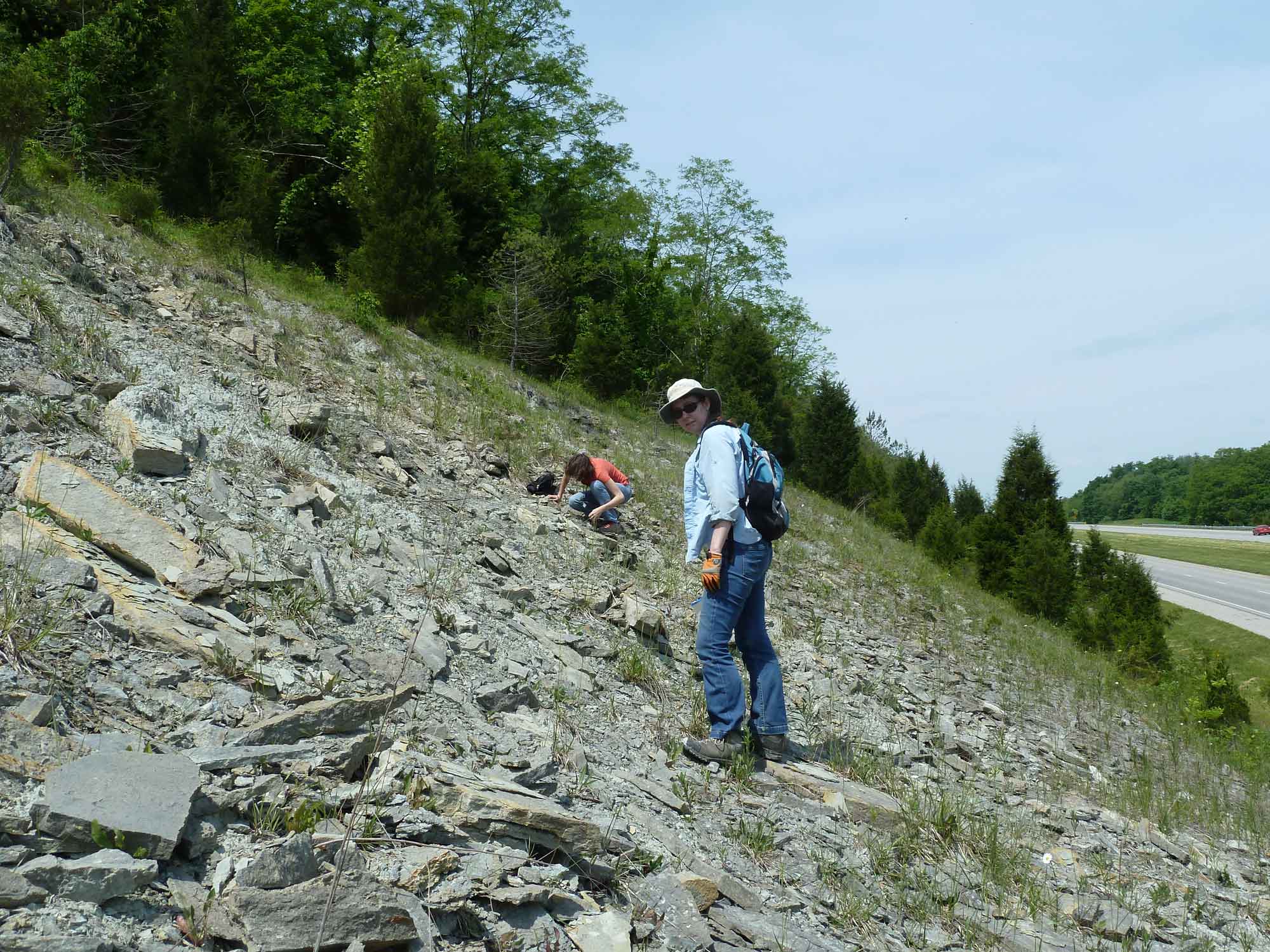
Paleontologists explore fossiliferous outcrops of Ordovician-aged limestone in southwestern Ohio. Photograph by Jonathan R. Hendricks.
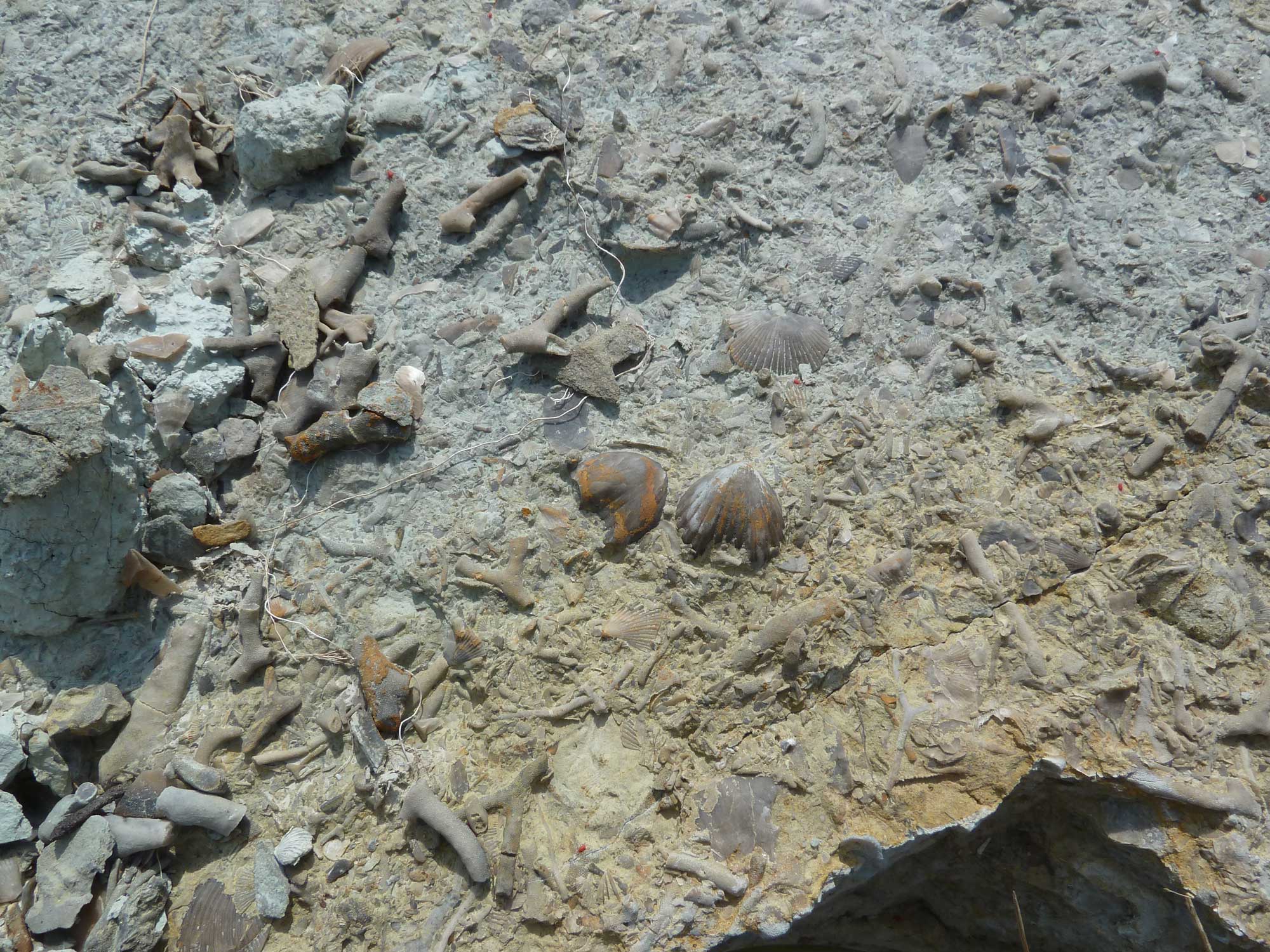
Fossil brachiopods and bryozoans in Ordovician-aged limestone from southwestern Ohio. Photograph by Jonathan R. Hendricks.
Similar processes continued through the Silurian and helped form many of the dominant ridges around the northwest of Lake Michigan, an arc through Lake Huron, and, most famously, the foundation of Niagara Falls in the east. The top of the escarpment is a hard dolostone, which protects the softer shales beneath it from erosion. This resistant capstone helps define the shapes of the basins of the Great Lakes, but these rock formations are also found beneath the surface in parts of Illinois, Michigan, and Ohio.
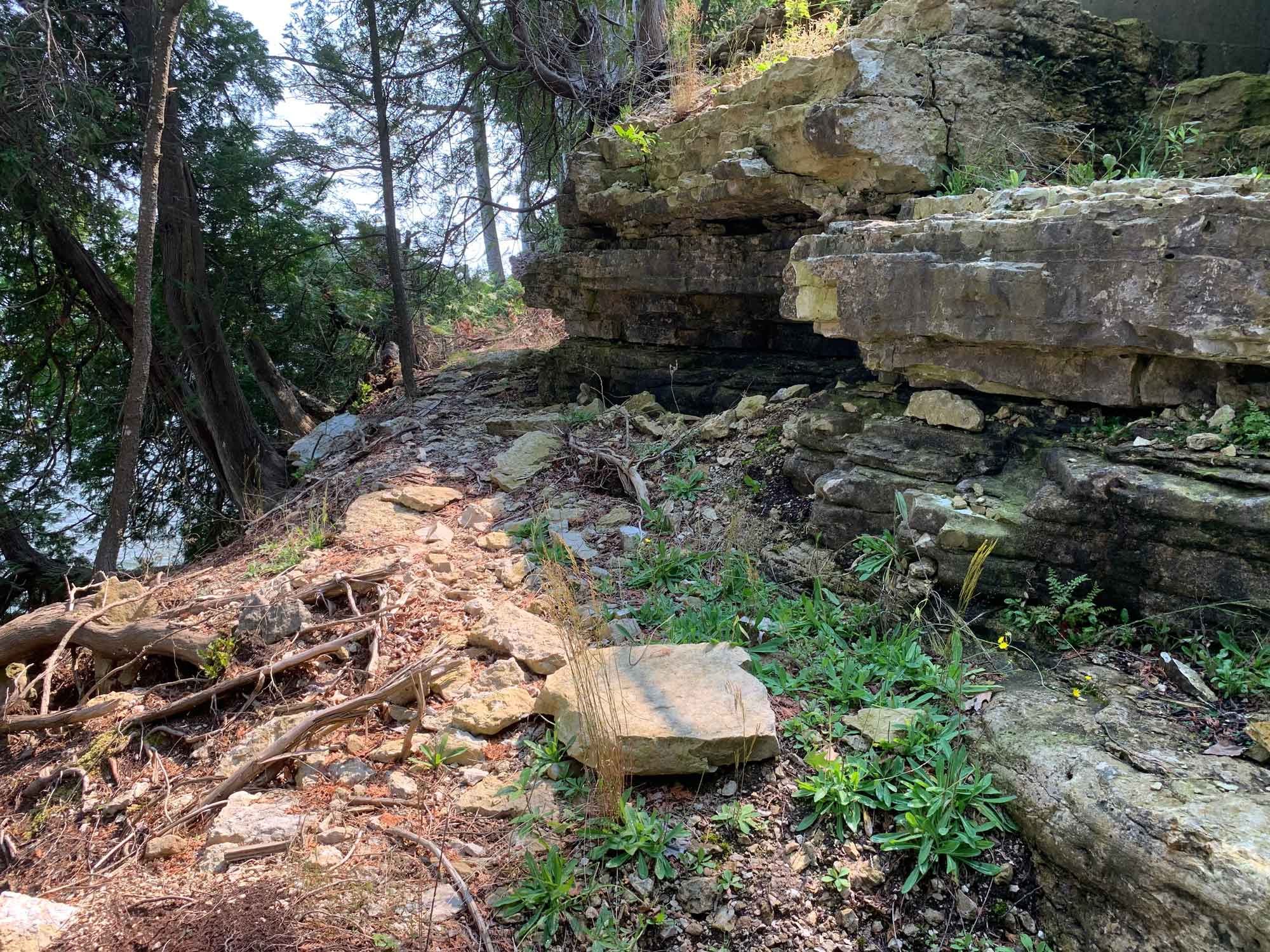
Silurian-aged dolostone bedrock on the shore of Green Bay, near Ellison Bay, Wisconsin. Photograph by Jonathan R. Hendricks.
In the east, Ohio and Indiana were sediment-starved as tens of millions of years of weathering made the Taconic Mountains low and mature, allowing reefs to cover the area and produce thick beds of limestone. West of Indiana, limestones were also deposited extensively, and often subsequently converted to dolostone. Relatively deep basins in Michigan were surrounded by reefs that reduced circulation. This resulted in increased salinity in the basin, leading to the deposition of salt and gypsum on the basin floor. Evaporation in shallow basins in Michigan and northern Ohio caused a similar process to occur, evidenced by the salt and gypsum deposits also present there.
The Devonian saw the formation of the Acadian Mountains in the east, which provided a new source of sediment to Ohio, Indiana, and Michigan. Because of this, rocks found in these states that date from this time are mostly shales and mudstones. Limestone and dolostone dominate the swath of Devonian rock in eastern Iowa, spilling over into Minnesota, Illinois, and Wisconsin.
Changes in sea level during the Mississippian and Pennsylvanian periods turned much of the Midwest into dry land at various times. Sequences of familiar marine rocks began to give way to sediments deposited near shore, in extensive deltas, and in freshwater settings. Sandstones and mudstones dominate the bedrock from these periods, as well as coal formed from vast volumes of vegetation from the swampy forests covering the region. For most of the Central Lowland, the rock record stops here—if much rock formed afterward, it was subsequently eroded away.
Mesozoic
In western Minnesota and Iowa, following a 240-million-year gap, rocks of the Cretaceous period are found. The oldest of these are sandstones deposited by rivers running towards the Western Interior Seaway. As time went on, the shores of the seaway moved eastward, laying down muddier sediment and finally limey shales, which sometimes contain marine fossils. Two isolated outcrops in Illinois contain sandstone and mudstone deposited by rivers flowing into an arm of the ancient Gulf of Mexico, called the Mississippi Embayment. One of these outcrops is in the Central Lowland, near Quincy, Illinois, while the other is at the southern tip of the state and is part of the Inland Basin.
Resources
Resources from the Paleontological Research Institution
Digital Encyclopedia of Earth Science: Minerals.
Earth@Home: Introduction to Rocks.
Earth@Home: Geologic time scale.
Earth@Home: Geologic maps.
Earth@Home Virtual Collection: Rocks (Virtual rock collection featuring 3D models of rock specimens sorted by type.)