

Spotlight: Overview of the rocks of the Superior Upland region of the midwestern United States, including Minnesota, Wisconsin, and Michigan.
Topics covered on this page: Overview; Resources.
Credits: Most of the text of this page is derived from "Rocks of the Midwestern US" by Richard A. Kissel and Alex F. Wall, chapter 2 in The Teacher-Friendly Guide to the Earth Science of the Midwestern US (published in 2014 by The Paleontological Research Institution and edited by Mark D. Lucas, Robert M. Ross, and Andrielle N. Swaby). The book was adapted for Earth@Home web by Elizabeth J. Hermsen and Jonathan R. Hendricks in 2022. Changes include formatting and revisions to the text and images. Credits for individual images are given in figure captions.
Updates: Page last updated December 12, 2022.
Image above: Proterozoic-aged Copper Harbor Conglomerate in the Porcupine Mountains of Michigan. Photograph by Curtis Abert (Flickr; Creative Commons Attribution 2.0 Generic license; image cropped and resized).
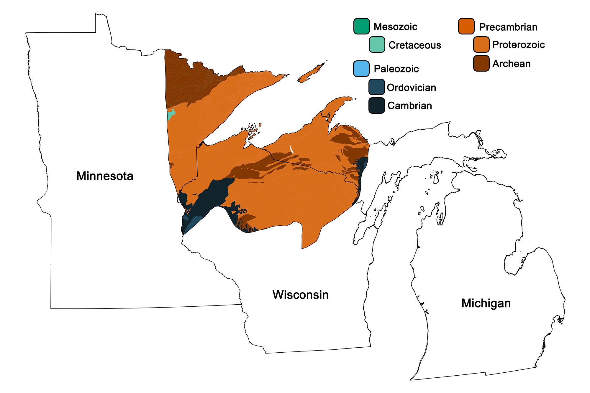
Geologic map of the Superior Upland region of the midwestern United States showing maximum ages of mappable units. Image by Jonathan R. Hendricks for the Earth@Home project developed using QGIS and USGS data (public domain) from Fenneman and Johnson (1946)and Horton et al. (2017).
Overview
The Superior Upland is the midwestern portion of the Canadian Shield, which extends from Minnesota to Nunavut and Greenland to New York. The shield as a whole represents the first portion of the North American continent to have emerged above sea level.
The Canadian Shield is the exposed portion of a larger craton. A craton can be thought of as the heart of a continent—it is typically the oldest, thickest, and most stable part of the bedrock. It is also usually far from the margins of tectonic plates, where new rock is formed and old destroyed. This very mature rock has usually been metamorphosed at some point during its history, making it very hard. The Canadian Shield is extremely old, hard rock was resistant to the weathering of repeated glacial advances, compared to the softer sedimentary strata to the south in the Central Lowland region, and this resulted in a higher, more rugged geographic upland.
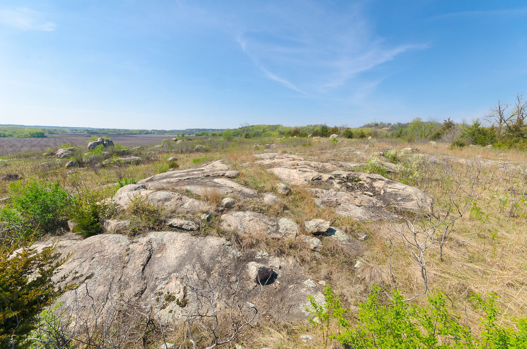
The oldest rock in the region, and indeed the United States, is the Morton Gneiss.
Outcropping of Morton Gneiss in Renville County, Minnesota. Photograph by Joshua Mayer (Flickr; Creative Commons Attribution-ShareAlike 2.0 Generic license).
The Morton Gneiss was initially formed 3.6 billion years ago, during the Archean Eon. For hundreds of millions of years, magma welled up from the mantle, creating the foundation of granite below the surface, a rock composed mainly of quartz, mica, and feldspar. These minerals have densities that are lower than both those of oceanic crust and the average density of the mantle, allowing this lighter rock to essentially float on the upper portion of the lithosphere. The lithosphere, in turn, is pushed around on the asthenosphere, which effectively acts as a conveyor belt.
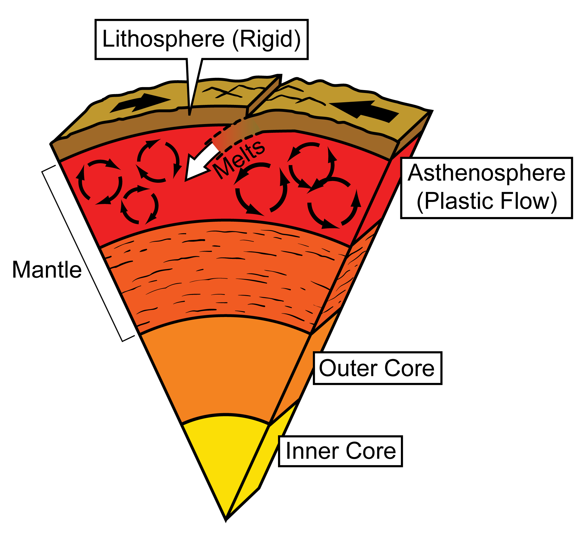
The layers of the Earth include the rigid crust of the lithosphere, which is constantly moving over the plastically flowing asthenosphere. Modified from original image by Jim Houghton.
Over its exceedingly long history, the Morton Gneiss was metamorphosed, resulting in alternating bands that are distinctive of gneiss.
Close-up view of a sample of Morton Gneiss, showing distinctive banding. Photograph by James St. John (Flickr; Creative Commons Attribution 2.0 Generic license).
Upwelling continued for hundreds of millions of years, injecting more and more magma into the region, which helped to metamorphose existing granite into gneiss. This magma would then cool to form yet more granite. This cycle continued until at least 2.7 billion years ago, though subsequent erosion could have erased rocks that are younger still. The result is a sequence of metamorphic and igneous rocks spanning nearly a billion years, remnants of which are found in northeastern Minnesota, northern Wisconsin, and parts of Michigan’s Upper Peninsula.
One of the chief causes of the metamorphosis of the ancient granites of the Superior Upland was the collision of the Superior Province with the Minnesota River Valley terrane around 2.7 billion years ago. This triggered a period of intense mountain building, called an orogeny, as the two small continents pressed on each other, causing their rock to buckle, which forced some of the rock up as mountains and some down to be subjected to even greater pressure and heat.
The Superior Province collides with the Minnesota River Valley (MRV) terrane, crumpling the margins of both continents. Modified from original image by Jim Houghton.
After a 200-million-year gap, the rock record picks up in the Proterozoic with 2.4-billion-year-old quartz sandstones and dolostones, which were deposited in a shallow marine environment. In some cases, these sedimentary rocks preserve ripple marks and stromatolites. Ancient glacial sediments are also found in the Superior Upland, evidence of the Huronian glaciation, which is thought to be the first-ever ice age on Earth. Following a gap of about 100 million years from 2.2 to 2.1 billion years ago, the sandstones reappeared and extended to 1.9 billion years ago.
Beginning about 2 billion years ago, thick and increasingly widespread banded iron formations also appear in the Superior Upland. As with much of the Canadian Shield, most of this rock has been metamorphosed to some degree: sandstones have become quartzite, dolomites have become marble, and banded iron formations have been deformed and folded. The Penokean Orogeny, from 1.9 to 1.8 billion years ago, transformed the area into a primarily erosional environment, so few rocks are preserved from this time. The tectonic activity did, however, force some magma up near the surface where it cooled into the granite found in northeastern Wisconsin and the Upper Peninsula.
About 1.1 billion years ago, a major event in the history of the Superior Upland took place when the North American continent began to split apart along the Midcontinental Rift. It is thought that a hot spot in the mantle caused a great upwelling of magma, centered near where Lake Superior is today. Over the course of 20 million years, the pressure from below caused the crust to spread in all directions, eventually thinning the Canadian Shield considerably.
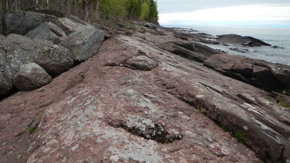
The rift eventually failed, but it left its mark on the region. Huge volumes of lava burst through to the surface, forming deposits of basalt. Magma of the same composition cooled underground to form gabbro. The tectonic activity also broke up many of these new rocks, producing large amounts of sediment that were preserved as sandstones and conglomerates. An age of 1.1 billion years is old even for a rock, yet this is currently the youngest exposed bedrock in the Superior Upland. On the southern and western shores of Lake Superior, one can see volcanic sequences, sandstones, and the Copper Harbor Conglomerate, evidence of the processes occurring during rifting.
The geology around Lake Superior is perhaps the most complex in the Midwest. A variety of sedimentary, igneous, and metamorphic rocks representing more than a billion years of history are found within a few kilometers of each other. Modified from original image by the USGS (public domain).
The Copper Harbor Conglomerate, Porcupine Mountains, Michigan. Photograph by Curtis Abert (Flickr; Creative Commons Attribution 2.0 Generic license).
While the rocks produced by the Midcontinental Rift are only found at the surface around Lake Superior, now-buried legs of the failed rift extend north into Canada, southeast nearly to Lake Erie, and southwest all the way to Kansas.
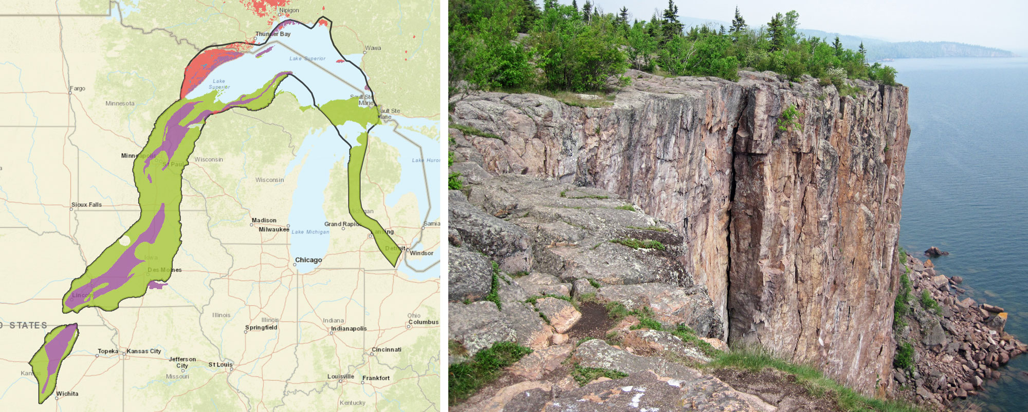
The Midcontinent Rift System. Left: Map showing the boundary of the Midcontinent Rift (black line) and the rocks types in it. Green = sedimentary rock; blue = metamorphic rock; purple = volcanic rock; pink = intrusive igneous rock. Map from USGS "Mineral Deposits of the Midcontinent Rift System" (U.S. government work/no other use policy found). Right: Palisade rhyolite (an extrusive igneous or volcanic rock), about 1.1 billion years old, shore of Lake Superior, northeastern Minnesota. Photo by James St. John (flickr, Creative Commons Attribution 2.0 Generic license, image cropped and resized).
Resources
Resources from the Paleontological Research Institution
Digital Encyclopedia of Earth Science: Minerals.
Earth@Home: Introduction to Rocks.
Earth@Home: Geologic time scale.
Earth@Home: Geologic maps.
Earth@Home Virtual Collection: Rocks (Virtual rock collection featuring 3D models of rock specimens sorted by type.)