

Snapshot: Metallic and non-metallic mineral resources in the Blue Ridge and Piedmont region of the southeastern U.S. Coverage also includes selected non-mineral resources the are commercially mined or quarried (for example, building stone).
Topics covered on this page: Introduction; Metallic mineral resources; Non-metallic mineral resources; Resources (references and further reading about minerals).
Credits: Most of the text of this page is derived from "Mineral resources of the Southeastern US" by Robert J. Moye, Stephen F. Greb, and Jane A. Picconi, chapter 5 in The Teacher-Friendly Guide to the Earth Science of the Southeastern U.S., 2nd ed., edited by Andrielle N. Swaby, Mark D. Lucas, and Robert M. Ross (published in 2016 by the Paleontological Research Institution; currently out of print). The book was adapted for the web by Elizabeth J. Hermsen and Jonathan R. Hendricks in 2021–2022. Changes include formatting and revisions to the text and images. Credits for individual images are given in figure captions.
Updates: Page last updated February 25, 2022.
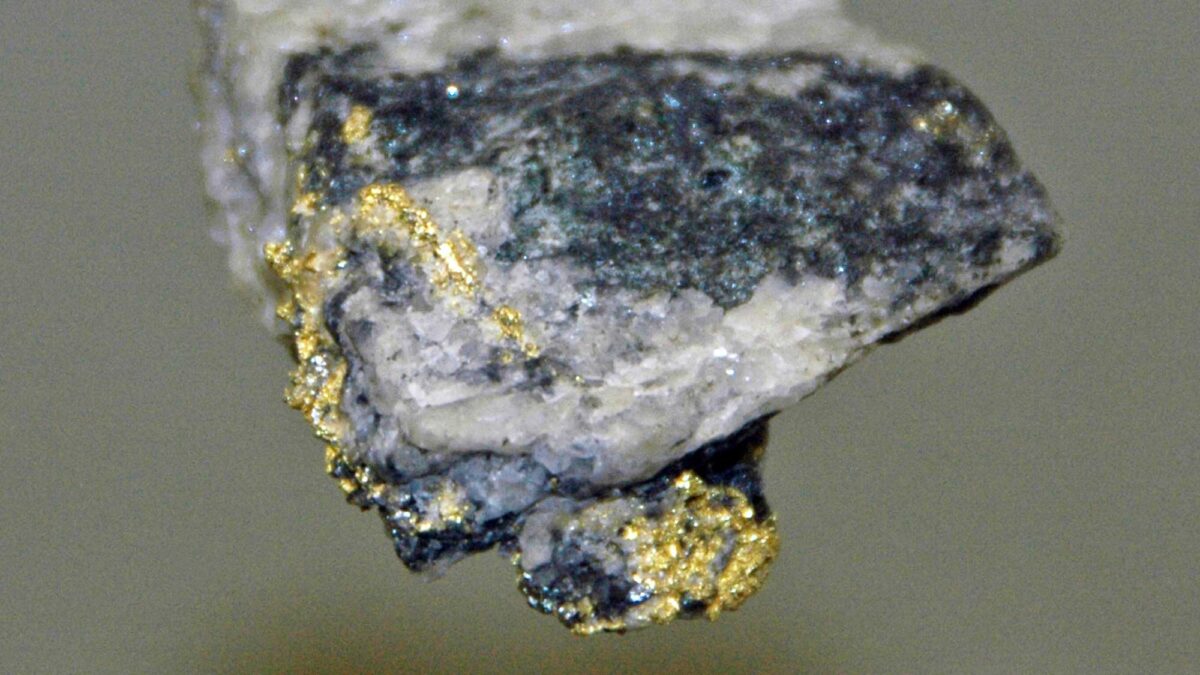
Image above: Rock sample from Georgia's Dahlonega Mining District showing gold veins. Photograph by James St. John (Flickr; Creative Commons Attribution 2.0 Generic license).
Introduction
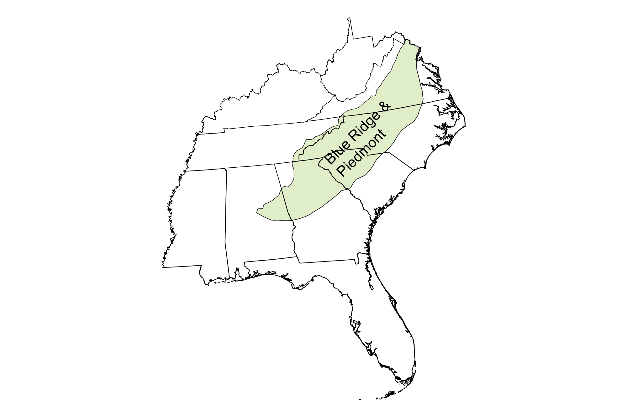
The Blue Ridge and Piedmont contains many distinct types of mineral deposits, which formed by different geologic processes throughout the Southeast's geologic history. Over the last billion years, these processes and their associated geologic environments have operated to produce the abundance and diversity of mineral deposits found in the region today.
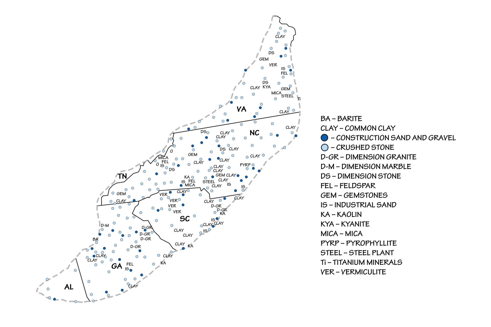
Principal mineral resources of the Blue Ridge and Piedmont regions of the southeastern United States.
Metallic mineral resources
Oxides
Titanium and iron oxide deposits, associated with igneous intrusions that occurred during the Grenville Orogeny, can be found scattered throughout the Grenville rocks that stretch from Virginia to Georgia. These rocks formed one billion years ago as the supercontinent Rodinia formed and ocean floor sediment was pushed onto ancient North America. The tectonic processes that formed the Grenville rock and mineral deposits are often obscured by strong metamorphism and deformation.
Titanium oxides
The titanium oxide minerals rutile and ilmenite were mined in the Roseland District of central Virginia (western Amherst and Nelson counties) between 1900 and 1971. This area once supplied a large percentage of the rutile consumed in the United States, used largely as a white pigment and an ingredient in refractory ceramics.
A crystal of rutile from Graves Mountain, Georgia. Length of specimen is approximately 6 cm. Model by Museum of Mineralogy and Petrography, UAIC (Sketchfab).
During the milling process, significant tonnages of the phosphate mineral apatite were also recovered, from which phosphorous chemicals were produced. From 1931 to 1971, the American Cyanamid Company operated a plant at Piney River, which refined the titanium ore and produced titanium dioxide for paint pigment. After the plant closed, its waste disposal sites remained behind. Today, the 20-hectare (50-acre) area is classified as a Superfund site. A Superfund site is a heavily polluted location, designated by the government to receive a long-term clean-up response in order to remove environmental hazards and contamination. This designation was given to the area surrounding the plant due to the leaching of highly acidic iron sulfate, which has degraded the Piney River's water quality, destroyed vegetation, and contaminated local groundwater. More than 200,000 fish died between 1977 and 1981 as a result of runoff from the plant's waste piles; today, about 200 people live within one mile of the site.
Iron oxides
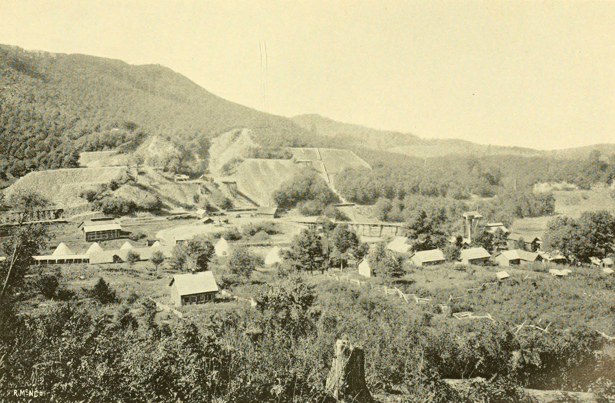
Small but rich magnetite (iron oxide) deposits at Cranberry, North Carolina occur in a 40-kilometer-long (24-mile-long) area associated with a large intrusion of gabbro, a dark-colored igneous rock. Around 1.5 million tons of high-purity magnetite was produced in this area of North Carolina from 1882 to 1930.
A banded iron formation extends for almost 137 kilometers (85 miles) through the Avalon rocks in North and South Carolina. Hydrothermal in origin, the iron was originally deposited in sediments on the ancient seafloor. These deposits were first mined just before 1760, and supplied iron for the weapons of the Continental Army during the American Revolution. The same banded iron formations were also a major source of iron for the weapons of the Confederate armies during the Civil War, including shot, cannonballs, and armor plates for naval ironclads. Production declined after the war and ended around 1900.
Cranberry Iron Mine, North Carolina, image from a book published in 1896. Photo from North Carolina Board of Agriculture (1896) North Carolina and its Resources. M. I. & J. C. Stewart, Winston. Accessed via the Internet Archive.
Manganese oxides
Manganese oxide deposits are locally present in the Blue Ridge and Piedmont's Precambrian rift basin sediment, especially in the Ashe Formation near the North Carolina-Virginia border. These include the deposits at Bald Knob, North Carolina, which are composed of manganese oxides, carbonates, and silicates. The formation of these manganese deposits is similar to that of the sulfide deposits described below, but here they took place at lower temperatures.
Sulfides
Sulfides, including iron, zinc, lead, and copper sulfides (galena, sphalerite, chalcopyrite, and pyrite), make up the majority of ore minerals in the Southeast's Precambrian rift basins, which formed during the breakup of Rodinia.
These sulfide minerals were largely deposited by hydrothermal processes. Seawater circulating through thick sequences of sediments, some of which were volcanic in origin, was heated by geothermal energy from subsurface magma. These hydrothermal fluids dissolved base metals, sulfur, and other elements from the sediments through which they migrated. Because the mineral-laden solutions were hot, they rose upward to the surface of the rift basins. As the hydrothermal fluids cooled at the surface, minerals precipitated from the solutions to form blankets of sulfides (including iron, copper, and zinc sulfides) within the rift basin sediments.
During the Taconic and Acadian orogenies, these deposits were folded to form thick lenses, and recrystallized into coarse crystals that are easily extracted. Numerous small sulfide deposits are present from southwest Virginia to northeast Georgia. The region's largest deposits are those found in the Gossan Lead District in the Ashe Formation of Virginia, with 28 kilometers (17 miles) of iron sulfide deposits, and the Ducktown District in Tennessee's Ocoee Basin, which contains nine separate sulfide bodies totaling almost 200 million tons of ore.
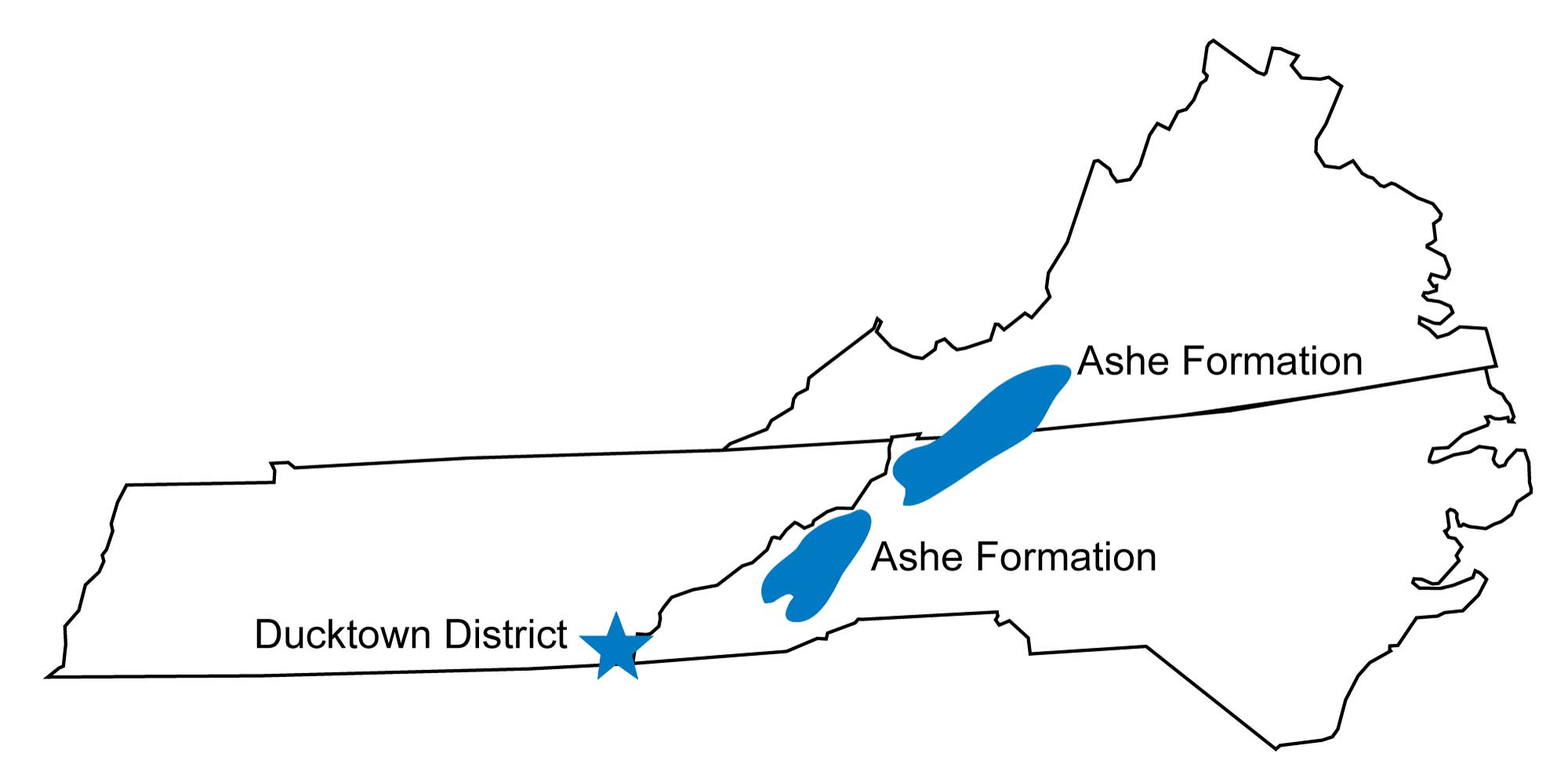
Map of showing the locations of the Gossan and Ducktown sulfide districts in Tennessee, Virginia, and North Carolina. Image modified from original by Jim Houghton.
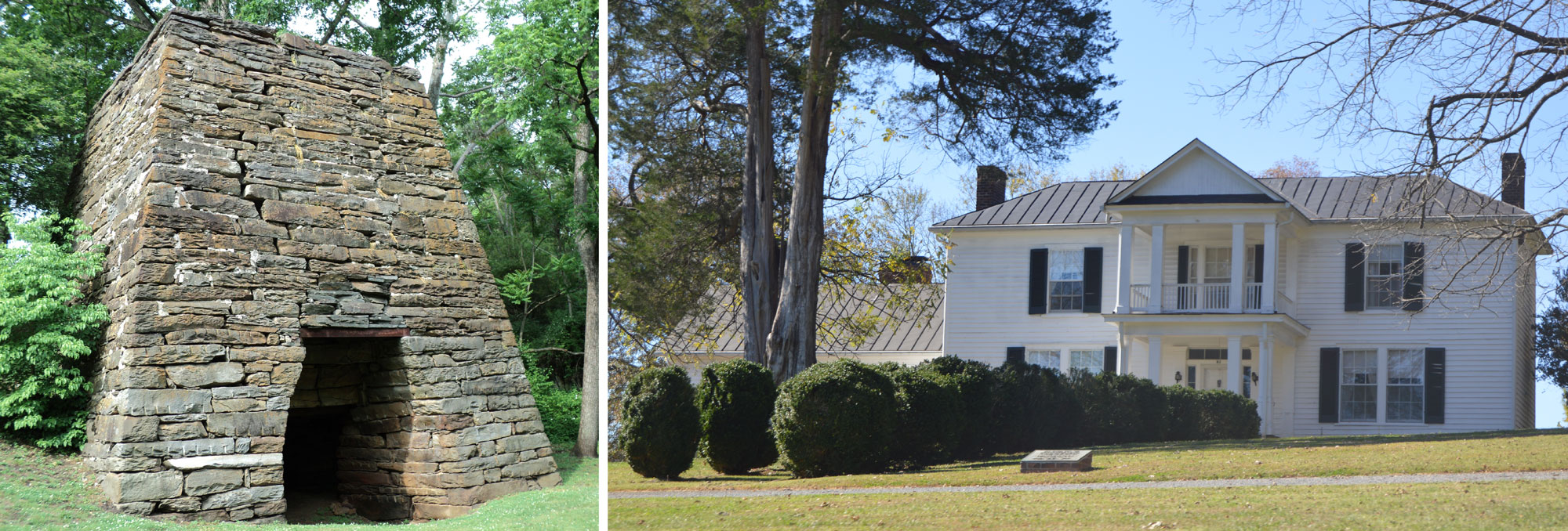
Structures associated with the former Washington Iron Works, located in Franklin County, Virginia. Left: Washington iron furnace, dating to ca. 1770. Photo by MarmadukePercy (Wikimedia Commons, Creative Common Attribution-ShareAlike 3.0 Unported license, image cropped and resized). Right: The Farm, which was the ironmaster's house, was built in 1818 and remodeled in 1850. Photo by Nyttend (Wikimedia Commons, public domain).
The Ducktown District was first worked in the early 1840s, initially for iron and later for gold formed by surface weathering of the sulfide ore bodies. The district also produced zinc and silver. Rich secondary copper ores were discovered below the gossans and mined from 1847 to 1879. Initially, the rich ore was piled on huge stacks of cordwood and set to burn for several weeks to oxidize the sulfur. The roasted ore was then placed in smelters fired by charcoal to recover the copper metal.
The entire valley was stripped of trees to fuel the roasters and smelters, consuming over 600 hectares (1500 acres) of mature timber each year by 1876. By 1878, 122 square kilometers (47 square miles) of forest had been consumed in and around the valley. Sulfur gases released by roasting and smelting fell with rain as sulfuric acid, killing virtually all remaining vegetation in the valley. High rainfall resulted in extensive erosion and gullying, producing terrain similar to a desert.
Mining of the primary sulfide ore bodies underground began in 1890, and continued until the end of the district's mining in 1987. Cleaner smelting technologies and extensive reclamation and planting efforts from the 1970s through the 1990s restored vegetation in much of the valley, an effort that continues to the present.
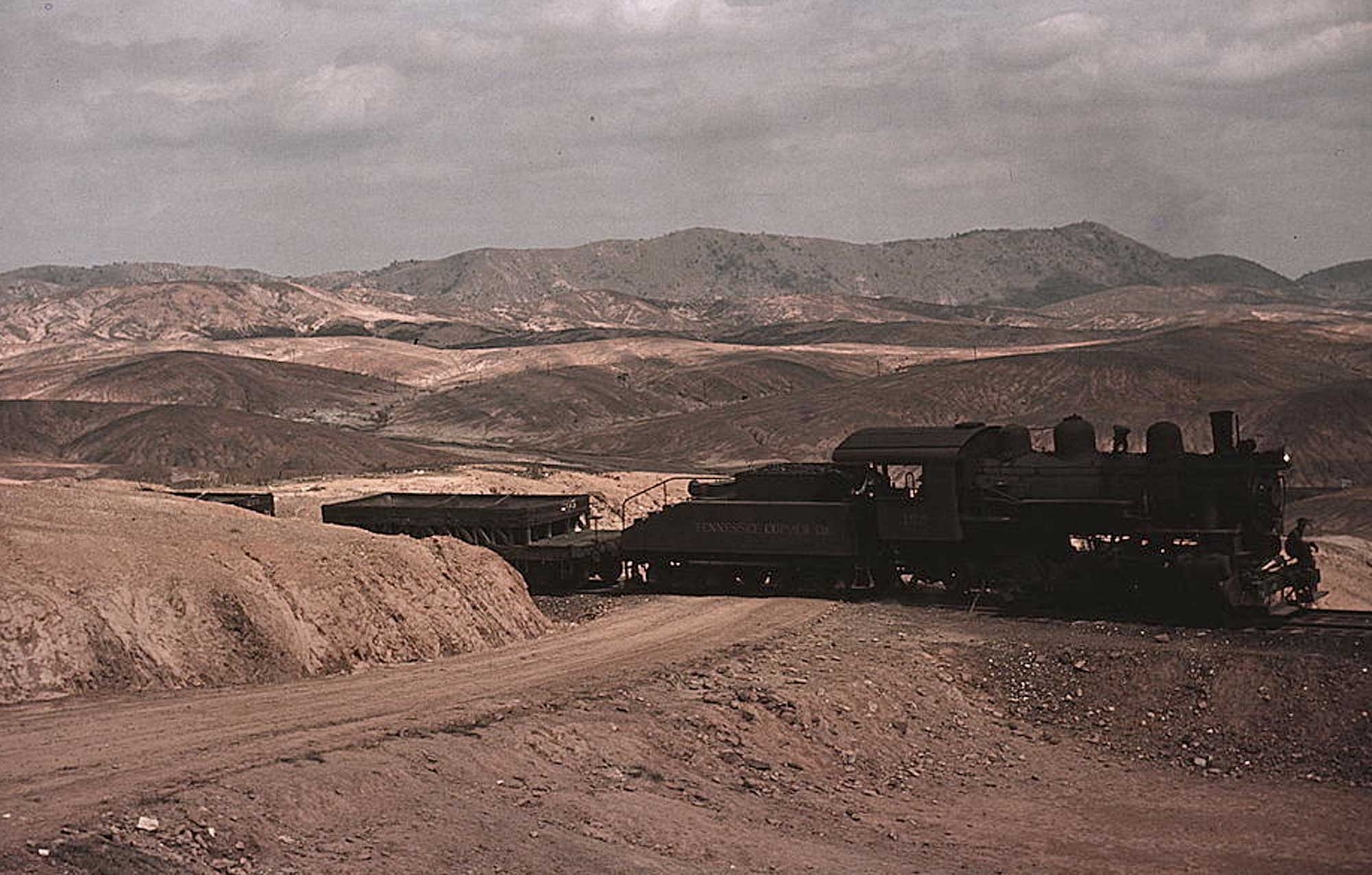
A train brings copper ore out of the mines in Ducktown, Tennessee in 1939. The absence of vegetation is a result of the fumes from nearby burning of sulfide ores. Photograph by United States Farm Security Administration (Wikipedia Commons; public domain).
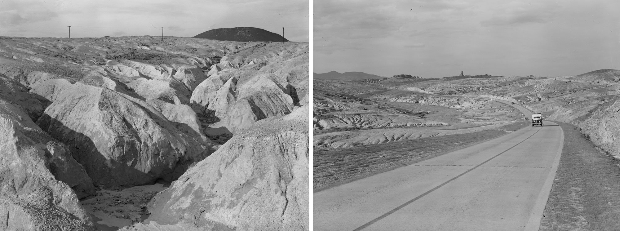
Additional images of environmental damage and erosion near Ducktown, Tennessee, in 1939. Photos by Marion Post Wolcott, U.S. Farm Security Administration/Office of War Information Black-and-White Negatives Collection, Library of Congress, no known copyright restrictions). Link to photo on the left. Link to photo on the right.
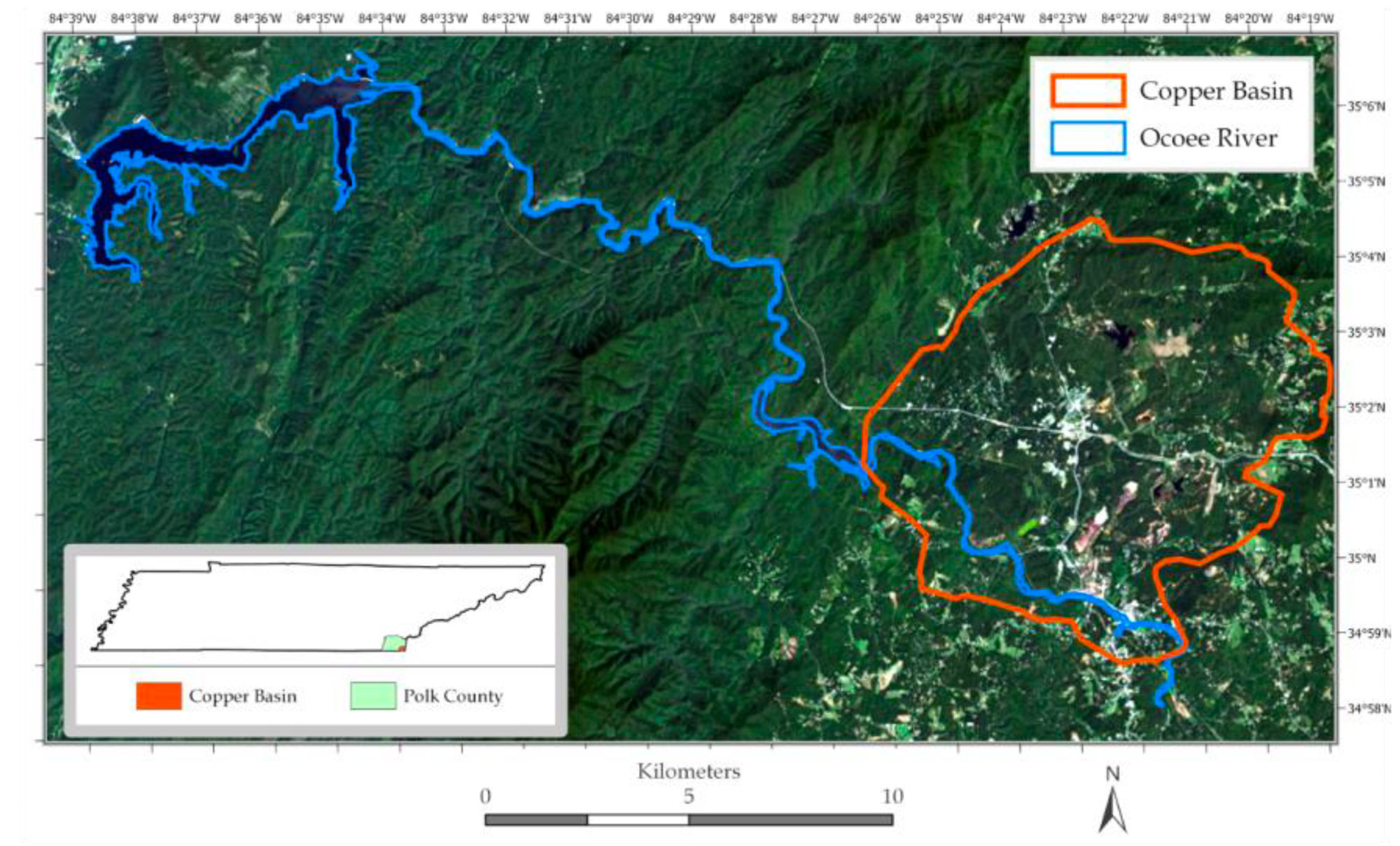
Map and satellite image of the Copper Basin (Ducktown region) of Tennessee ca. 2020. The inset map shows the extent of the Copper Basin in southeastern Tennessee. The satellite image shown the Copper Basin (orange outline) region, which was previously heavily deforested. Figure 1 from R. Blanton and A. K. M. Azad Hossain (2020) GeoHazards 1: 31–43 (Creative Commons Attribution 4.0 International license, image resized and cropped).
During mountain building in the Cambrian and Ordovician, hydrothermal fluids migrated along fractures and thrust faults, following units of permeable rock. Minor occurrences of zinc and lead sulfides from this time period are present in the Blue Ridge, and there are several large barite deposits formed along thrust faults—for example, the barite deposits found in the Hot Springs District of Madison County, North Carolina. Because it is heavy, soft, and chemically inert, barite is widely used as an additive and filler, largely to increase the density of lubricating muds used in oil and gas drilling.
Native elements: gold and silver
The rocks of the Inner and Outer Piedmont host numerous hydrothermal sulfide and gold deposits, although most were relatively small and largely mined out in the 19th century.
Many of the region's high-grade gold deposits are concentrated within quartz veins. In the Outer Piedmont, numerous deposits of sulfides (copper, lead, and zinc), gold, iron, manganese, barite, and tungsten are associated with Precambrian to Cambrian volcanic activity and igneous intrusions that occurred before the Avalon terrane was attached to North America. The Carolina Slate Belt, a weak to moderately metamorphosed section of Avalon rocks that stretches over 970 kilometers (600 miles) from Georgia to Virginia, is thought to contain significant quantities of undiscovered gold and silver.
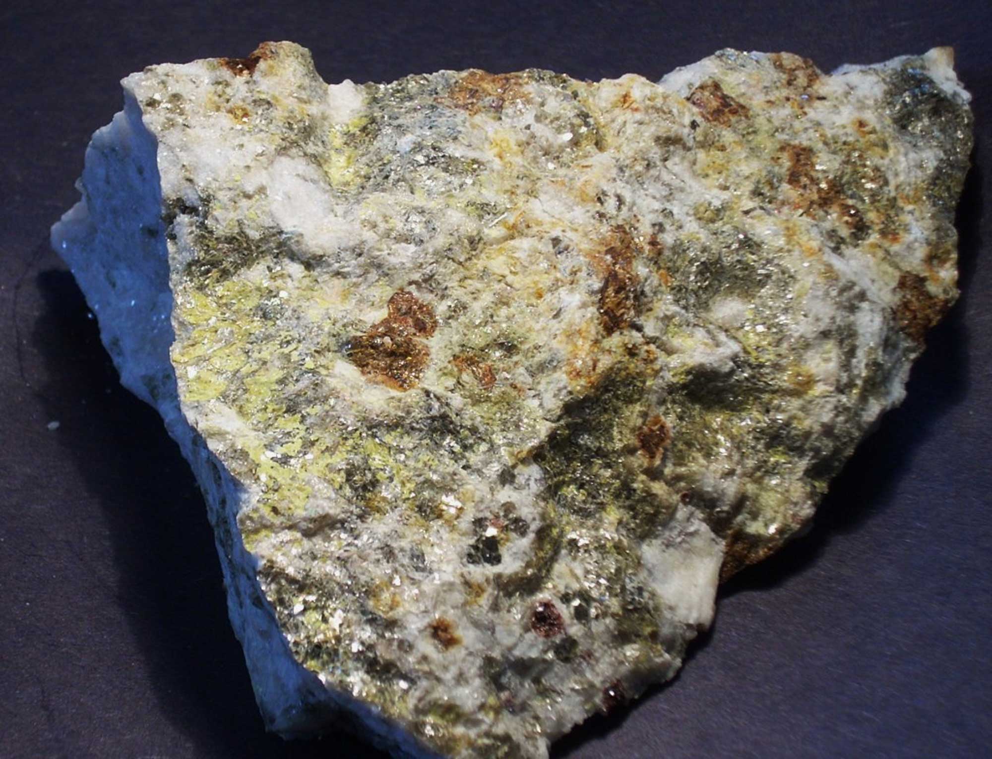
A lead-rich ore with patches of silver, from the Silver Hill Mine in the Carolina Slate Belt, Davidson County, North Carolina. Specimen is 8.8 centimeters (3.5 inches) wide. Photograph by Robert M. Lavinsky (Wikimedia Commons; Creative Commons Attribution-Share Alike 3.0 Unported license; image size changed).
Many of these deposits also contain abundant pyrite, sometimes in crystals up to 20 centimeters (8 inches) across. The deposits were modified, and in some cases further concentrated, by hydrothermal processes accompanying the Acadian and Alleghanian orogenies. Subsequent weathering and erosion formed rich placer and residual gold deposits that were the initial target of mining in the Piedmont. Alluvial mining gave way to lode mining as placer deposits were exhausted and the gold was traced to its source in the bedrock. Although much of the Blue Ridge and Piedmont's gold has already been commercially extracted, gold panning and sluicing is a popular recreational activity in many parts of the region.
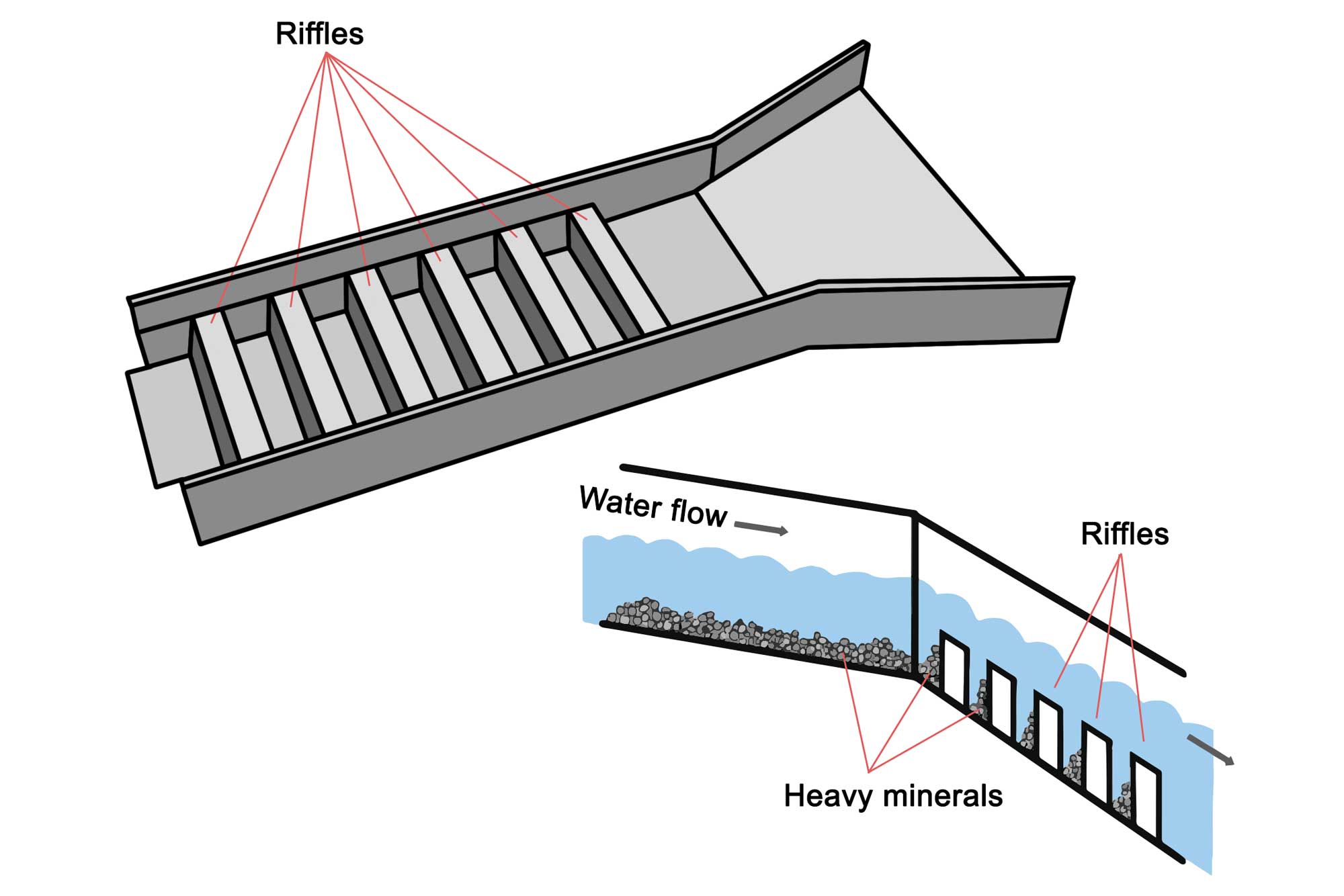
A sluice is a long tray through which water that contains gold is directed. The sluice box contains riffles, or raised segments, which create eddies in the water fl ow. Larger and heavier particles, such as gold, are trapped by the eddies and sink behind the riffles where they can later be collected. Image modified from original by Wade Greenberg-Brand.
Gold was first reported in North Carolina in 1774, but the Carolina Gold Rush began after 12-year-old Conrad Reed found an 8-kilogram (17-pound) gold nugget on the family farm in 1799. Mining had begun at deposits in five North Carolina counties by 1820, and 14 kilograms (500 ounces) of North Carolina gold arrived at the US Mint in Philadelphia in 1824. Mining experts and engineers were recruited from Britain, Germany, Italy, and South Africa, and miners came to the Southeast from more than a dozen countries. The Carolina Gold Rush spread through the southeastern Piedmont from Virginia to Alabama and westward across the Blue Ridge by 1830, and included the deposits of the Inner Piedmont.
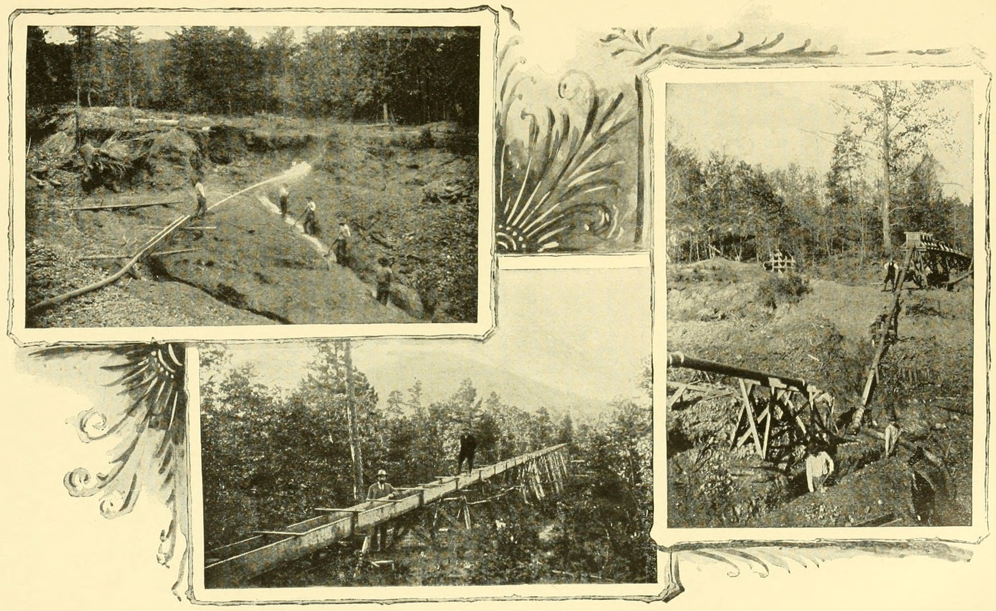
Placer (sluice) mining in Burke County, North Carolina; image from a book published in 1896. Photo from North Carolina Board of Agriculture (1896) North Carolina and its Resources. M. I. & J. C. Stewart, Winston. Accessed via the Internet Archive.
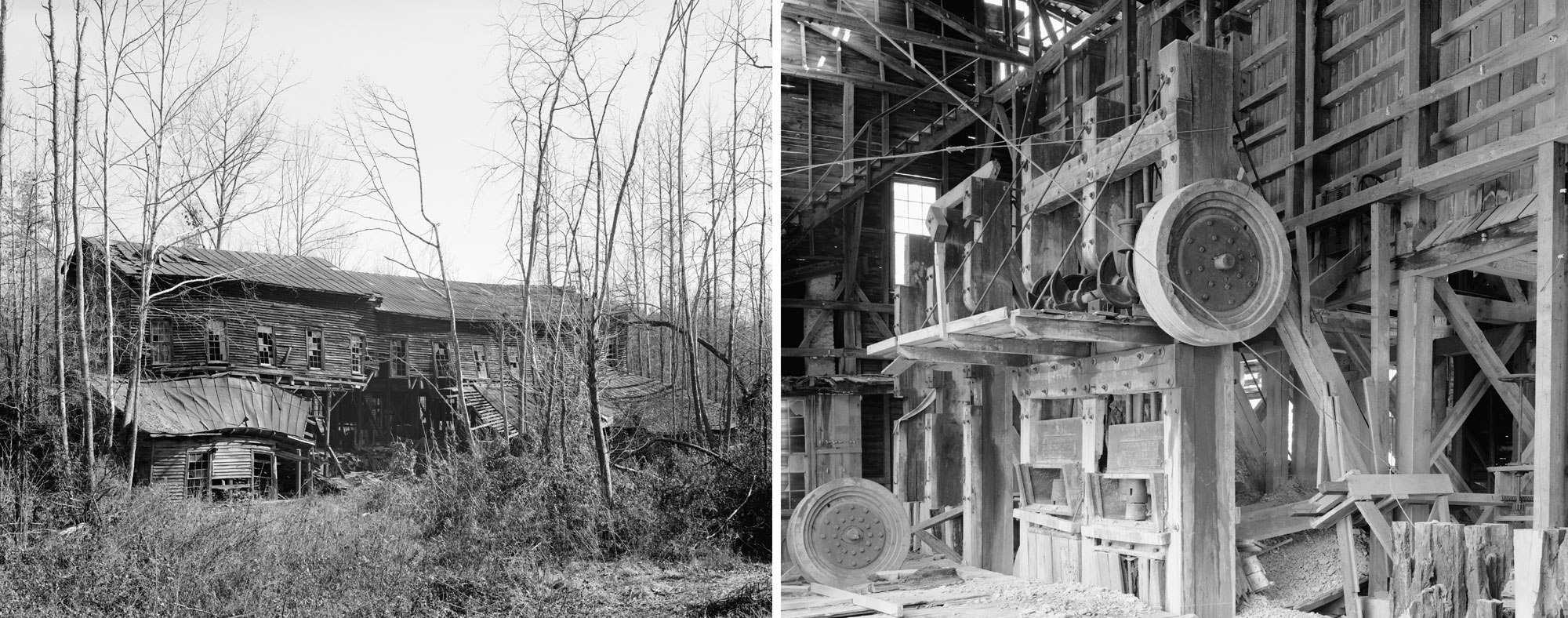
The abandoned Coggins Gold Mine, Rich-Cog Mining Company, Eldorado, North Carolina. The mine was active between 1882 and 1934. These photos were taken in 1978. Left: Abandoned wooden building. Photo by JoAnn Sieburg-Baker (Reproduction no. HAER NC, 62-ALBE, 1--3, Historic American Buildings Survey Collection, Library of Congress, no known restriction on images made by the U.S. government). Right: Milling equipment. Photo by JoAnn Sieburg-Baker (Reproduction no. HAER NC, 62-ALBE--12, Historic American Buildings Survey Collection, Library of Congress, no known restriction on images made by the U.S. government).
There are over 300 known gold, silver, and base metal mines and prospects in Virginia, but the most important are clustered in a narrow zone of volcanic rocks called the Virginia Gold-Pyrite Belt, which extends for about 160 kilometers (100 miles). At least 100 old gold mines are present along this trend, opened along veins and sulfide deposits of hydrothermal origin. Total gold production from Virginia from 1804 through 1947 was 9300 kilograms (330,000 ounces). Copper, zinc, and lead from sulfide deposits also were mined in this area.
Northern Georgia's Dahlonega Belt—volcanic rocks containing rich hydrothermal gold-bearing quartz veins and sulfide deposits—produced over 14,000 kilograms (500,000 ounces) of gold between 1838 and 1941.
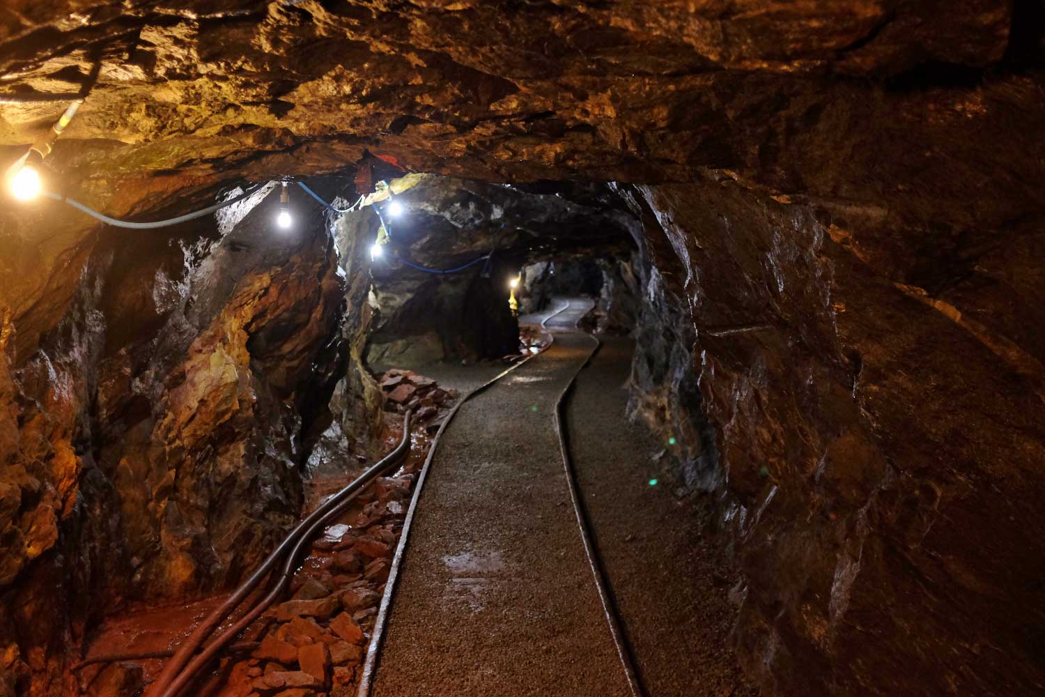
A view into the tunnels of the Consolidated Gold Mine, Dahlonega, Georgia. This mine was the site of one of the world's largest gold-bearing quartz veins, and it is the largest hard rockgold mine east of the Mississippi. Photograph by Neal Wellons (Flickr; Creative Commons Attribution-NonCommercial-NoDerivs 2.0 Generic license).
The Cherokee were aware of the presence of gold on their lands, and gold mines were operated illegally in Cherokee Territory as early as 1819. The "official" discovery of gold in Georgia was made in 1828 by Frank Logan in present-day White County, well within the territory of the Cherokee Nation. This led to a period of feverish prospecting known as the Georgia Gold Rush.
As word of the gold discovery spread, a systematic campaign to remove the Cherokee and open the area to gold mining was crafted in Georgia and Washington, DC. In 1830, Congress quickly passed the Indian Removal Act. In December 1835, the US government signed a treaty with a small group of disaffected Cherokee, none of whom were elected officials of the Cherokee Nation. Twenty signed the treaty, ceding all Cherokee territory east of the Mississippi to the US, in exchange for $5 million and new homelands in the Indian Territory (Oklahoma). More than 15,000 Cherokees protested the illegal treaty, but the US Senate ratified it by one vote.
Most of the Cherokee people were forced to leave their ancestral home in northern Georgia and adjacent states, and relocate to the Indian Territory in the winter of 1838–1839. Over 4000 Cherokee died as a result of the removal, nearly a fifth of the Cherokee population. Their journey is called "The Trail of Tears."
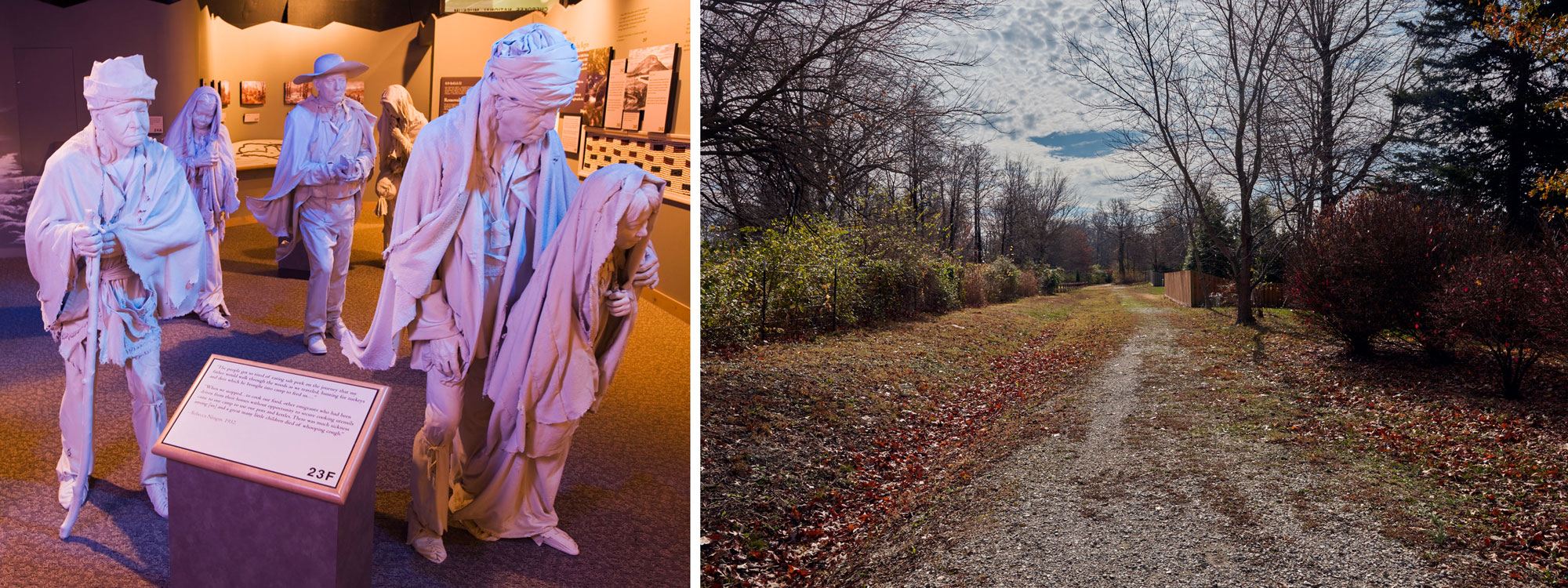
Left: Exhibit at the Cherokee National Museum showing sculptures of Cherokee people on the Trail of Tears. Photo uncredited, National Archives and Records Administration (National Archives Indentifier 7717616, use unrestricted). Right: Preserved portion of the route used on the northern Trail of Tears, Springfield, Missouri, 2020. Photo by Carol M. Highsmith (Reproduction no. LC-DIG-highsm-64387, Carol M. Highsmith Archive, Library of Congress, no known restrictions on publication).
South Carolina was the scene of a modern-day gold rush between 1985 and 1999, with four major open-pit mines—the Ridgeway Mine (Fairfield County), Barite Hill Mine (McCormick County), Brewer Mine (Chesterfield County), and Haile Mine (Lancaster County)—in operation. Total gold production from the entire Southeastern Piedmont through 1969 is estimated at 77,000 kilograms (2.7 million ounces). South Carolina's production from 1985 to 1999 increases this figure to about 123,000 kilograms (4.35 million ounces) of gold.
Uranium ore
Uranium ore is found in Triassic-Jurassic rift basin sediments that were deposited as Pangaea began to split apart. The uranium was transported in dissolved form by groundwater, then concentrated in the sediments and deposited. In 1982, the Marline Uranium Corporation announced the discovery of a 30-million ton deposit of uranium ore in Pittsylvania County, Virginia. The ore body is developed in an intrusion of gneiss in the Danville rift basin. This uranium deposit was never commercially developed, due to a drop in uranium ore prices and local opposition to the project.
Non-metallic mineral resources
Silicate minerals from pegmatites
During the Taconic and Acadian orogenies, numerous pegmatites (intrusive igneous rocks with mineral grains > 2 cm) intruded Precambrian rift rocks throughout the Blue Ridge. Many of these pegmatites have been mined for a variety of silicate minerals, including feldspar, kaolinite, quartz, and mica.
A portion of a feldspar-rich pegmatite from Pine Mountain Mine in Mitchell County, North Carolina, with inclusions of muscovite mica and garnet. Specimen is 13 centimeters (5 inches) wide. Image Mike Dennis (Wikimedia Commons; public domain).
Among the most important districts for pegmatite mining are the Franklin-Sylva and Spruce Pine districts in North Carolina, where hundreds of pegmatites intrude into the Ashe Formation. These two districts have produced over half of all U.S. sheet and scrap mica and feldspar since mining began there in 1868, and North Carolina remains the nation's top producer. Ancient mine pits and shafts in the Blue Ridge Mountains of North Carolina were long thought to be pre-colonial silver and gold prospects attributed to early Spanish explorers, but these old prospects are now thought to be the work of Native Americans who mined the pegmatites for sheets of muscovite mica.
Beryl is a common mineral in some pegmatites, and mines in the Spruce Pine District have produced gem quality aquamarine and emerald (varieties of beryl). Pegmatites are also widespread in the Inner Piedmont, although they are generally no longer mined there.
Lithium-rich pegmatite deposits between Lincolnton, North Carolina and Gaffney, South Carolina represent one of the largest concentrations of silicate lithium in the world. An unusual group of lithium-bearing pegmatites in Alexander County, North Carolina produces gem-quality emeralds and hiddenite, a gem form of spodumene.
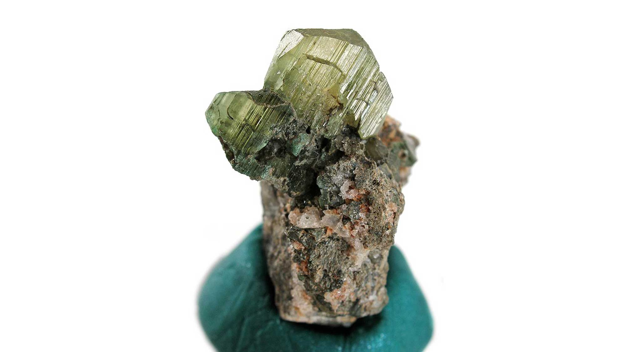
A crystal of hiddenite, a variety of spodumene, from the Adams Hiddenite and Emerald Mine in North Carolina. Hiddenite was first discovered in Alexander County, North Carolina in 1879. A nearby community was also named after the mineral. Image by Rob Lavinsky (Wikimedia Commons; Creative Commons Attribution-Share Alike 3.0 Unported license; image dimensions and size changed).
Olivine
The silicate mineral olivine, concentrated in the ultramafic igneous rocks dunite and peridotite, is present throughout the Blue Ridge from Virginia to Alabama. It occurs in highly deformed Precambrian rift rocks that were thrust westward onto the margin of North America during the Taconic Orogeny.
Western North Carolina leads the nation in olivine production; the Webster-Balsam District in Jackson County and the Spruce Pine District in Yancey and Mitchell counties have produced commercial quantities of this mineral for use in industry and as the gemstone peridot. Ultramafic deposits in the Blue Ridge have also produced minor quantities of asbestos and chromite.
Sample of the rock dunite that is composed mostly of green olivine. Sample is from near Balsam, North Carolina and its longest dimension is approximately 8.5 cm. Model by "rocksandminerals"(Sketchfab; Creative Commons Attribution 4.0 International license).
Vermiculite
In the Inner Piedmont, Paleozoic metamorphism formed deposits of the sheet silicate mineral vermiculite, which used in lightweight concrete aggregates, insulation, agriculture, and other products. The United States is one of the two largest producers of vermiculite in the world; all U.S. production comes from deposits in the Inner Piedmont of Virginia and South Carolina.
Talc
Talc deposits are associated with the Murphy Marble in a belt extending through Cherokee and Swain counties, North Carolina. The talc formed through tectonic-metamorphic alteration of silty dolomite or associated sediments during one of the Paleozoic orogenic events. While talc, a type of sheet silicate, can form from a variety of parent materials, including ultramafic rocks rich in olivine, talc formed from dolomitic marbles tends to be cleaner and more pure, making the Murphy deposits economically viable. These deposits were mined as early as 1859 and well into the 1980s, but are currently inactive. The district has produced over 200,000 tons of high-grade talc.
Corundum
Paleozoic mountain building altered the Blue Ridge and Piedmont's ultramafic rocks, resulting in the formation of distinctive localized deposits. In the Blue Ridge, deposits of corundum are common. Corundum, which is an aluminum oxide, is used as an abrasive, and in gem form is known as ruby (red) or sapphire (blue). The Macon County area of North Carolina continues to produce gem-quality forms of corundum, especially rubies and sapphires—in 1985, two rubies totaling almost 1000 carats with an uncut value of around $40,000 were found there.
Crushed stone, sand, gravel, and clay
The Blue Ridge and Piedmont also produces numerous industrial minerals in the form of crushed stone, sand and gravel, and common clays. Holocene sand and gravel deposits found along streams and terraces are locally quarried for use as construction aggregate, which is used to strengthen concrete, make blacktop, produce building materials, and as road and dam foundations.
Limestone, and to a lesser extent dolomite (dolostone), is also mined and crushed for use as aggregate, and Georgia is the national leader in the production of granite used as crushed stone. Some types of sand are quartz rich, which makes them useful for other industrial purposes. This "industrial sand" is used in sandblasting, filtering, and the manufacturing of glass, and is mined from quartz-rich Paleozoic sandstones and quartzites.
Dimension stone
Dimension stone is the commercial term applied to quarried blocks of rock that are cut to specific dimensions and used for buildings, monuments, curbing and facing. Granite, limestone, and sandstone are often quarried as dimension stone. The largest open-face granite quarry in the world is located at Mt. Airy, North Carolina.
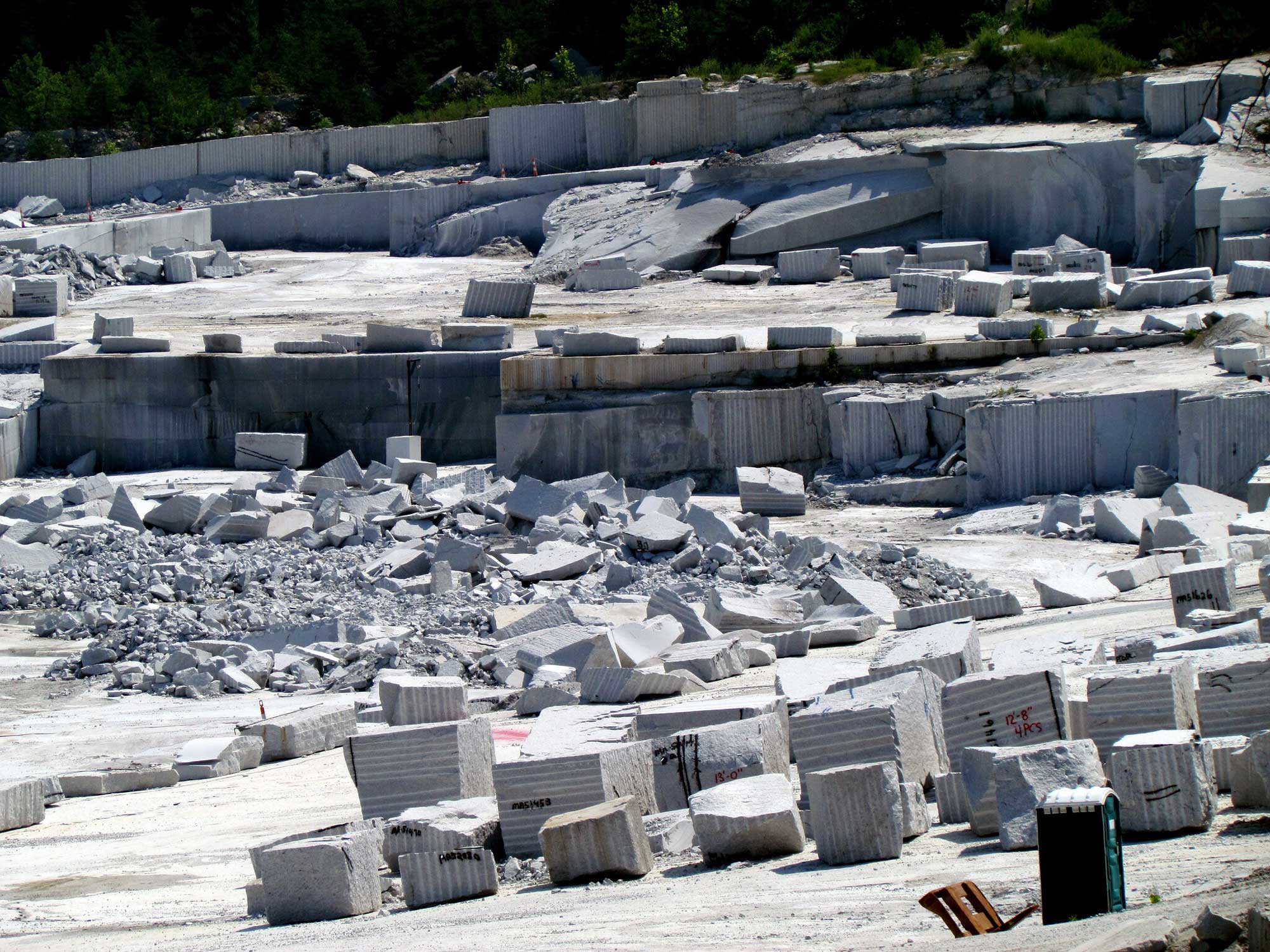
The open-faced granite quarry at Mt. Airy, North Carolina, produces over 610,000 meters (2 million feet) of white granite each year for use in construction and facing. The quarry was opened in 1743, and covers an area of roughly 372,000 square meters (4 million square feet). Image by "bobistraveling" (Flickr; Creative Commons Attribution 2.0 Generic license).
Polished granites from Georgia (in particular the Elberton area) and North Carolina have been used in many government buildings and monuments, including the US Capitol building and the Jefferson Memorial in Washington, DC.
Resources
Resources from the Paleontological Research Institution
Digital Atlas of Ancient Life: Minerals (collection of 3D models on Sketchfab): https://skfb.ly/6WxTo
Digital Encyclopedia of Earth Science: Minerals: https://earthathome.org/de/minerals/