

Page snapshot: Introduction to the fossils of the Great Plains region of the southwestern United States.
Topics covered on this page: Paleozoic fossils; Mesozoic fossils; Triassic fossils; Jurassic fossils; Cretaceous fossils; Cretaceous fossils of the Western Interior Seaway; Latest Cretaceous terrestrial fossils; Cenozoic fossils; Paleogene fossils; Paleocene fossils; Eocene to Oligocene fossils; Quaternary fossils; Resources.
Credits: Most of the text on this page comes from "Fossils of the Southwestern US" by Warren D. Allmon and Richard A. Kissel, chapter 3 in the The Teacher-Friendly Guide to the Earth Science of the Southwestern US, edited by Andrielle N. Swaby, Mark D. Lucas, and Robert M. Ross (published in 2016 by the Paleontological Research Institution; currently out of print). The book was adapted for the web by Elizabeth J. Hermsen and Jonathan R. Hendricks in 2022. Changes include formatting, revisions, and additions to the text and images. Credits for individual images are given in figure captions.
Updates: Page last updated August 26, 2022.
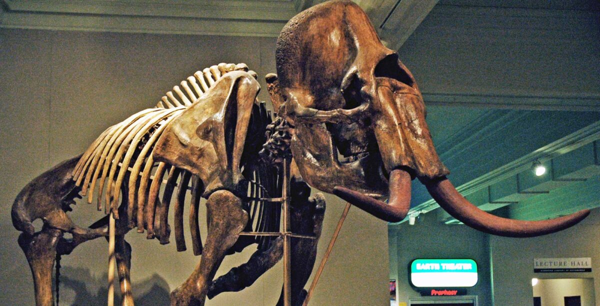
Image above: Columbian mammoth (Mammuthus columbi) from the late Pleistocene Dent Site, Weld County, Colorado. This mammoth was found with Clovis-style spear points, suggesting that it was killed during a hunt. Specimen on display at the Carnegie Museum of Natural History, Pittsburgh, Pennsylvania. Photo by James St. John (flickr, Creative Commons Attribution 2.0 Generic license, image cropped and resized).
Paleozoic fossils
The Great Plains of eastern Colorado, northern New Mexico, Oklahoma, Kansas, and northern Texas are dominated by Mesozoic- and Cenozoic-aged rocks. In the southeastern corner of New Mexico, however, is an extension of the Permian Basin. During the Permian period, this area contained a marine environment. Today, it is home to the largest, best preserved, most accessible, and most intensively studied Paleozoic reef in the world, the Capitan Reef. The Capitan Reef stood about 600 meters (2000 feet) above the adjacent deep sea basin.
Like modern reefs, this reef complex was built from the shells of marine invertebrates. Most of the shells were made of calcium carbonate (CaCO3), which has the same composition as limestone. After the reef was buried by sediment, much of its calcium carbonate was replaced by other minerals dissolved in groundwater. The most important of these minerals was silica (SiO2), which has the same composition as glass. The resulting “glass” fossils can be freed from their surrounding limestone by treating the rock with acid, which dissolves the rock but leaves the delicate fossils behind. The late Permian rocks of westernmost Texas and southeastern-most New Mexico contain almost 1000 species of brachiopods, sponges, gastropods, foraminifera, algae, and other marine organisms.
For more images of fossils from the Permian reef complex in the southeastern New Mexico-western Texas region, see the Earth Science of the South-Central United States: Fossils of the Basin and Range page, which shows a selection of fossils from western Texas.
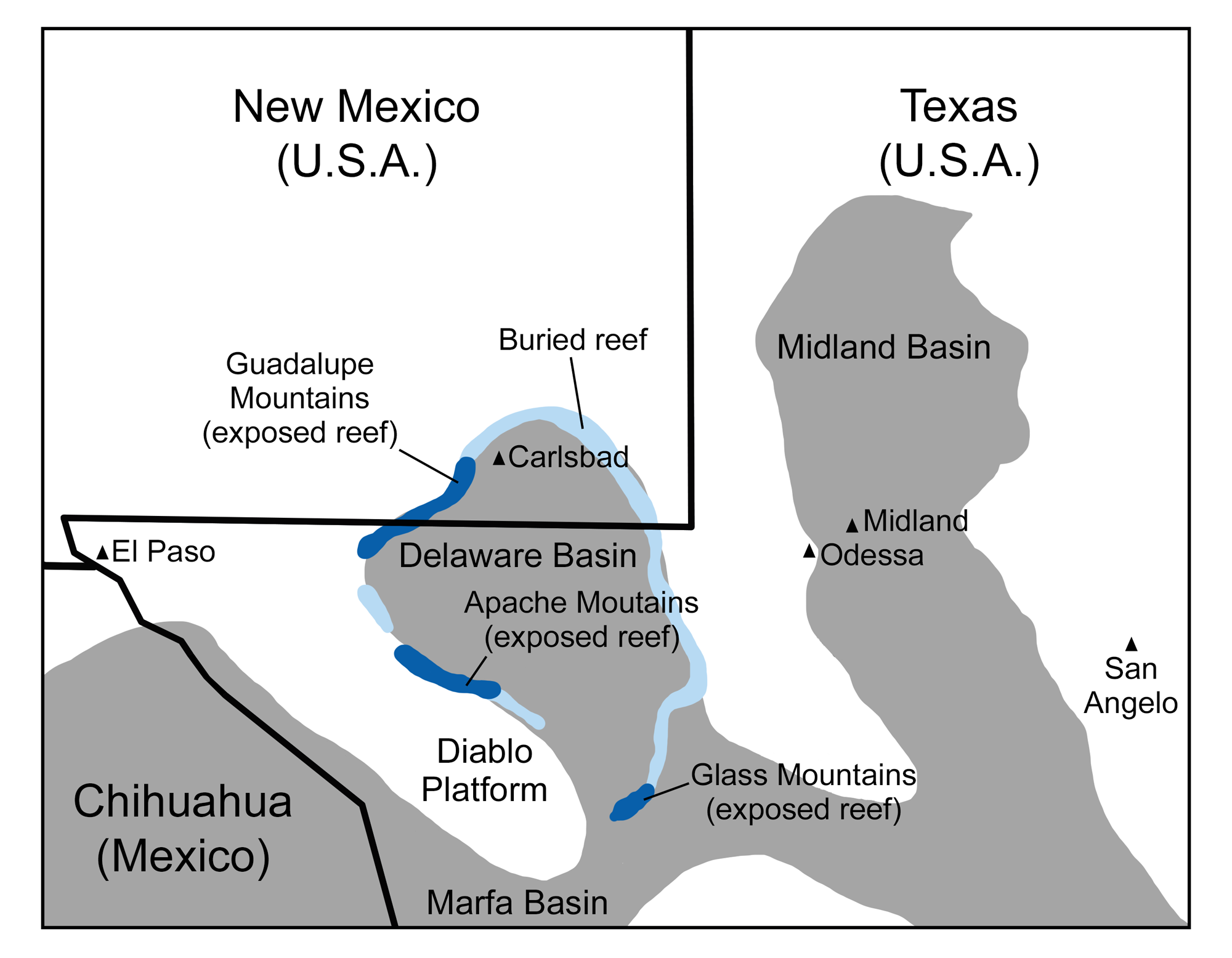
Permian reefs of New Mexico and Texas: Map showing the paleogeographic relationship of the reefs to the topographic lows and highs of the shallow sea that covered the Texas-New Mexico-Chihuahua region in the Permian. The reef occupied the rim of the Delaware Basin. Original map by Wade Greenberg-Brand, modified for the Earth@Home project.
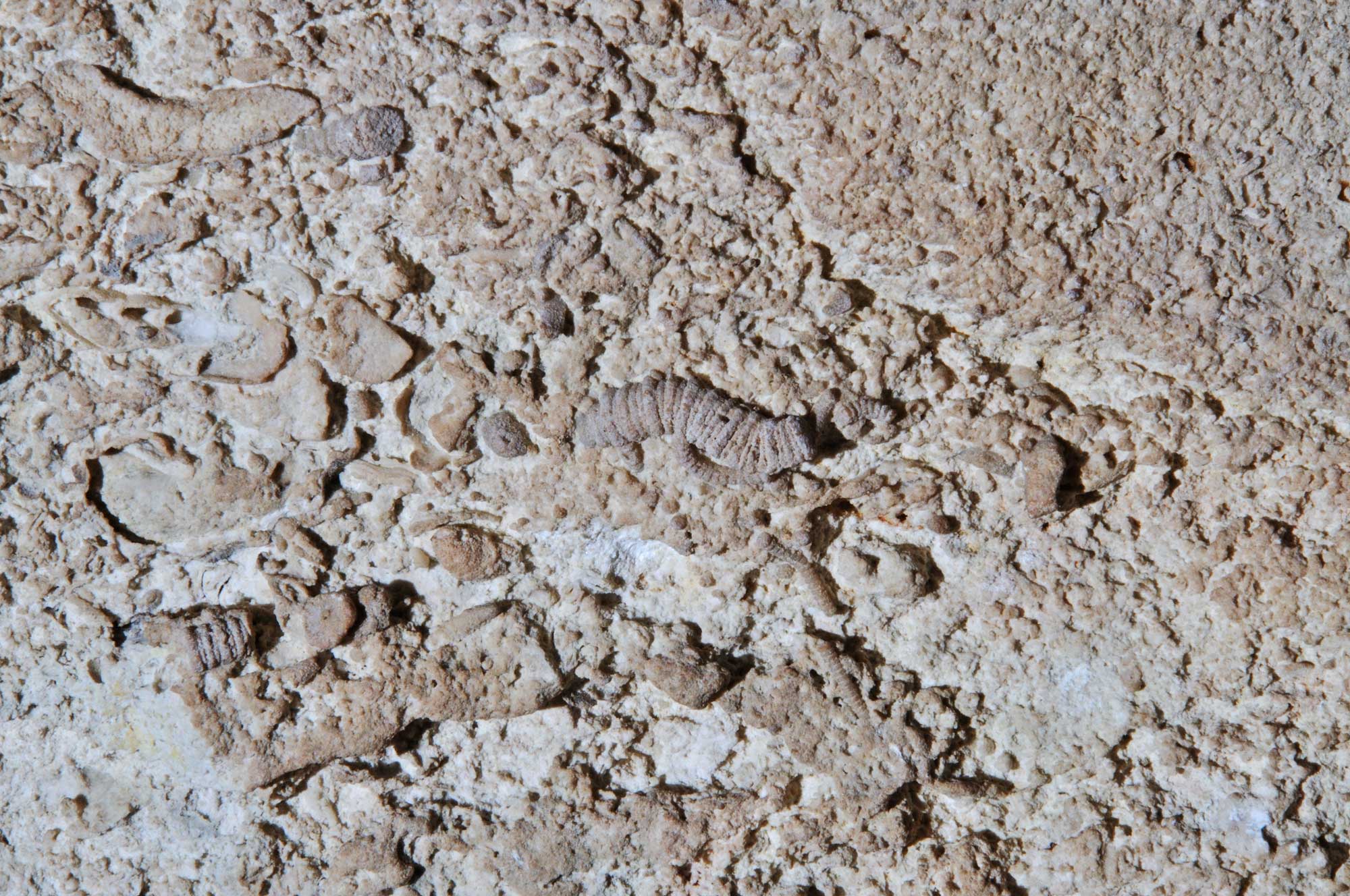
Permain fossils in limestone, Carlsbad Caverns National Park, New Mexico. Photo by Dale Pate (National Park Service, public domain).
Mesozoic fossils
Triassic fossils
Triassic fossils are known from the Bull Canyon and Redonda formations (Chinle Group or Dockum Group) of east-central New Mexico. Fossils from eastern New Mexico are from groups of animals that also occur in the Triassic Chinle Formation of the Colorado Plateau and the Triassic (Chinle Group or Dockum Group) of the Texas Panhandle region. These include ray-finned and lobe-finned fishes, amphibians, and various types of reptiles, like armored aetosaurs and crocodile-like phytosaurs.
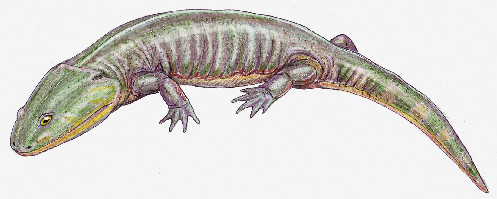
A reconstruction of the temnospondyll amphibian Apachesaurus, known from the Triassic Redonda Formation, New Mexico. Drawing by Dmitry Bogdanov (Wikimedia Commons, Creative Commons Attribution-ShareAlike 3.0 Unported license, image cropped).
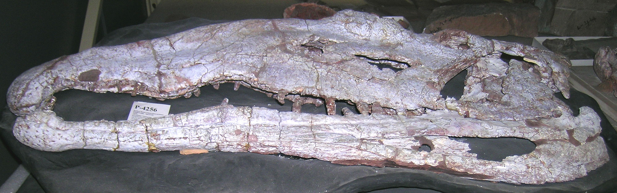
The skull of a phytosaur (Barrancasuchus sealeyi) from the Triassic Bull Canyon Formation, Quay County, New Mexico. Photo of specimen NMMNH P-4256 (New Mexico Museum of Natural History, Creative Commons Attribution-NonCommercial-ShareAlike 3.0 Unported license, image cropped and resized).
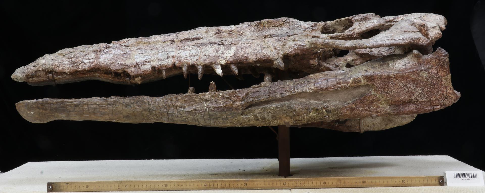
The skull of a phytosaur (possibly Pseudopalatus buceros) from the Triassic Redonda Formation, Quay County, New Mexico. Photo of specimen YPM VP 003293 by Vanessa R. Rhue (Yale Peabody Museum of Natural History/YPM, CC0 1.0 Universal/Public Domain Dedication, accessed via GBIF.org).
Jurassic fossils
Dinosaurs are also well represented across much of the Southwest through fossil footprints. The Purgatoire River tracksite, also called the Picketwire Canyonlands tracksite, is one of the largest dinosaur tracksites in North America. The tracks occur in the widespread Morrison Formation. The site is located in the Comanche National Grassland along the Purgatoire River south of La Junta, Otero County, Colorado.
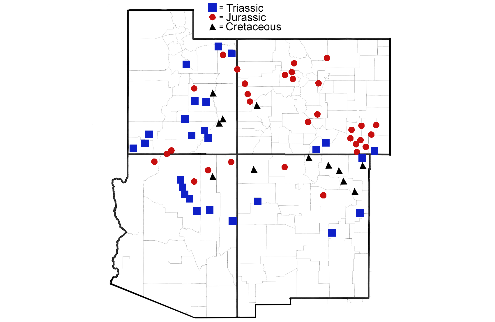
Major localities in which Mesozoic footprints (mostly dinosaurs) have been found. Map modified from a map by Alana McGillis that was compiled from multiple sources. Originally published in The Teacher-Friendly Guide to the Earth Science of the Southwestern US.
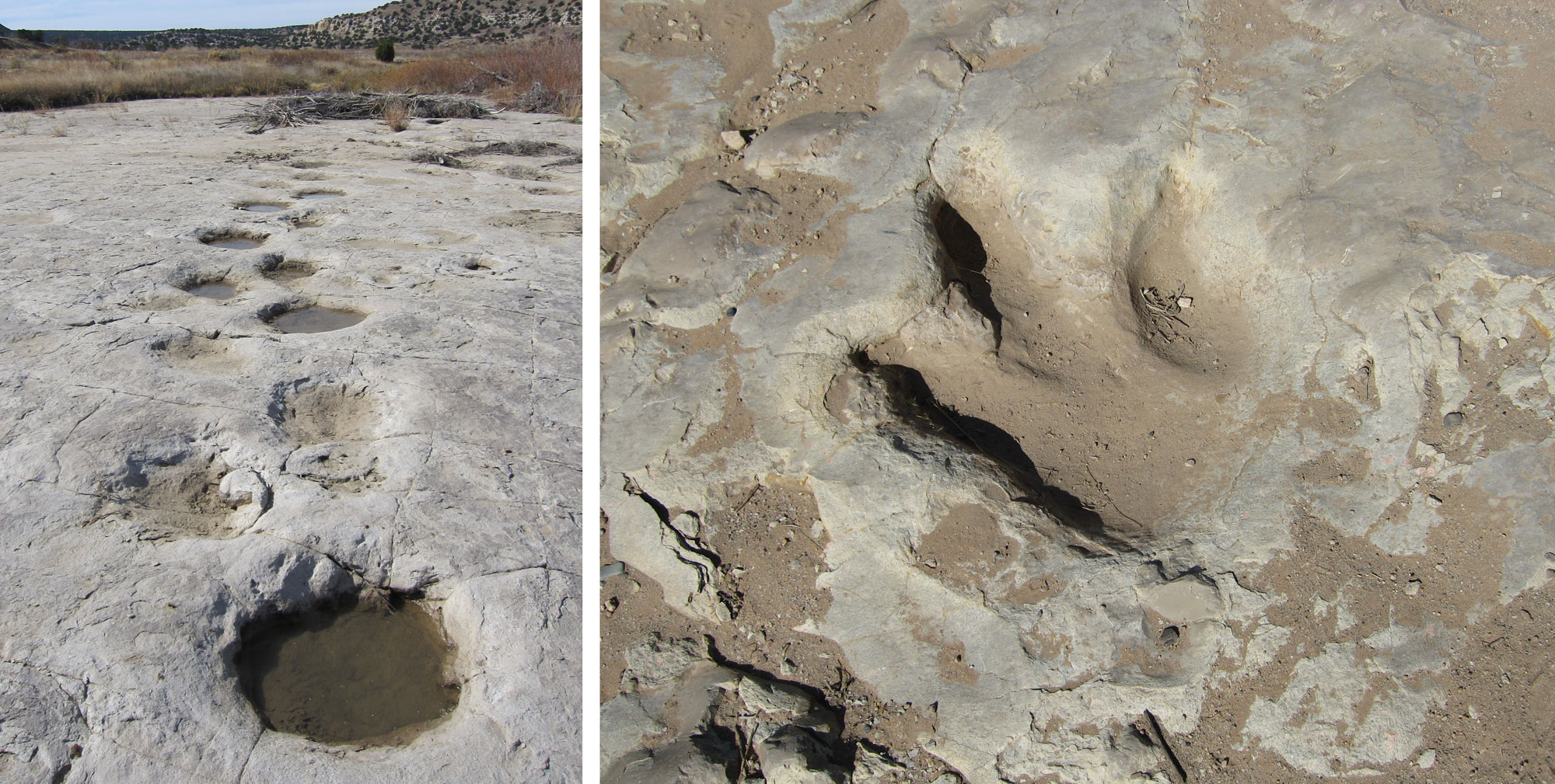
Dinosaur tracks (left, sauropod tracks; right, theropod track) at the Purgatoire River Tracksite, Comanche National Grassland, Colorado. Left image by Chris M. Morris, 2009 (flickr, Creative Commons Attribution 2.0 Generic license, image cropped and resized). Right image by Mark Gallagher, 2005 (flickr, Creative Commons Attribution 2.0 Generic license, image cropped and resized).
Cretaceous fossils
Cretaceous fossils of the Western Interior Seaway
The Cretaceous rocks of Colorado produce an abundance and diversity of marine fossils from the end of the Mesozoic. Fossils of ammonoids, bivalves, fish, and marine reptiles document the life of the shallow sea. Along the sea’s margins to the west, dinosaur footprints and flowering plants are preserved in what were once forested and swampy coastal areas. To the east, the fossils of open-water animals, such as mosasaurs, plesiosaurs, turtles, sharks, and other fishes—including the massive Xiphactinus—are preserved. In addition to strictly aquatic animals, the Cretaceous deposits of Colorado also preserve the remains of pterosaurs and toothed birds. These fossils are generally preserved in deposits of chalk (which is itself formed mostly from the shells of single-celled plankton) that accumulated at the bottom of the sea 80 to 90 million years ago.
For more images of fossils from the Wester Interior Seaway in the southeastern eastern Colorado-western Kansas region, see the Earth Science of the South-Central United States: Fossils of the Great Plains page, which shows a selection of fossils from western Kansas.
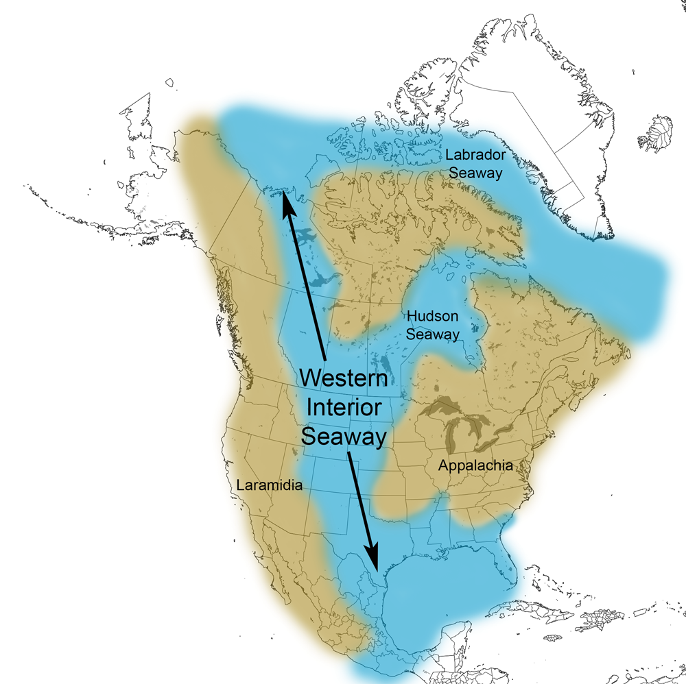
Extent of the Western Interior Seaway during the Cretaceous Period. Image from Cretaceous Atlas of Ancient Life: Western Interior Seaway (Creative Commons Attribution-NonCommercial-ShareAlike 4.0 International license).
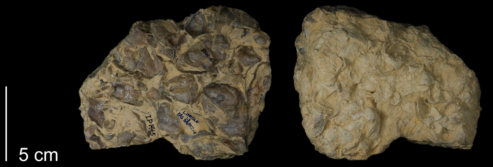
Fossil oysters (Ostrea beloiti) from the Late Cretaceous Greenhorn Formation, Las Animas County, Colorado. Image of specimen FHSMIP 1445 (Sternberg Museum of Natural History, Cretaceous Atlas of Ancient Life: Western Interior Seaway, Creative Commons Attribution-NonCommercial-ShareAlike 4.0 International license).
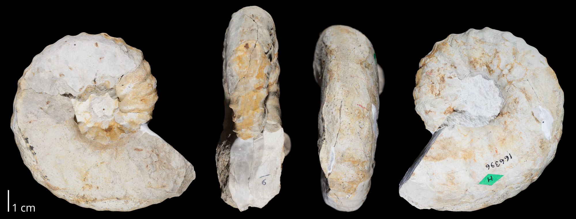
Fossil ammonoid (Nigericeras scotti) from the Late Cretaceous Greenhorn Limestone, Baca County, Colorado. Photo of USNM 166396 from the Cretaceous Atlas of Ancient Life (Creative Commons Attribution-NonCommercial-ShareAlike 4.0 International license, image cropped).
Latest Cretaceous terrestrial fossils
The Raton and Vermejo formations of northern New Mexico and southern Colorado preserve an abundant fossil record from the latest Cretaceous period. The Raton Formation is the source of what is widely accepted as the only known footprint of Tyrannosaurus rex. The Raton Basin is also an area where the K-Pg boundary is preserved. One notable place where it can be seen is at Trinidad Lake near Trinidad, Colorado.
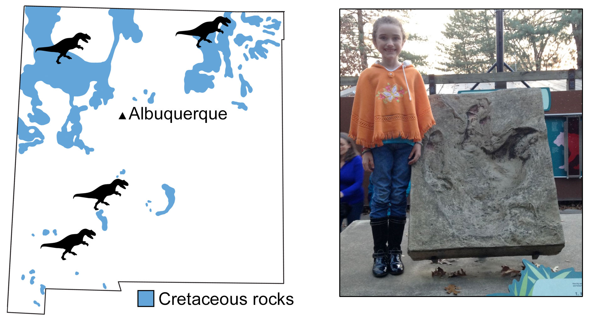
Tyrannosaurs in New Mexico. Left: State of New Mexico showing the distribution of Cretaceous rocks (blue) and locations where tyrannosaur fossils have been found (silhouettes). Right: Cast of the only dinosaur footprint ever confidently assigned to Tyrannosaurus rex, found in the Raton Formation near the town of Cimarron, Colfax County, New Mexico. The print measures 86 centimeters (about 34 inches) long. Cast on exhibit at the Smithsonian Institution's National Zoo, Washington, D.C. Credits: Map modified from a map by Wade Greenberg-Brand and photo by Warren Allmon. Both originally appeared in The Teacher-Friendly Guide to the Earth Science of the Southwestern US.
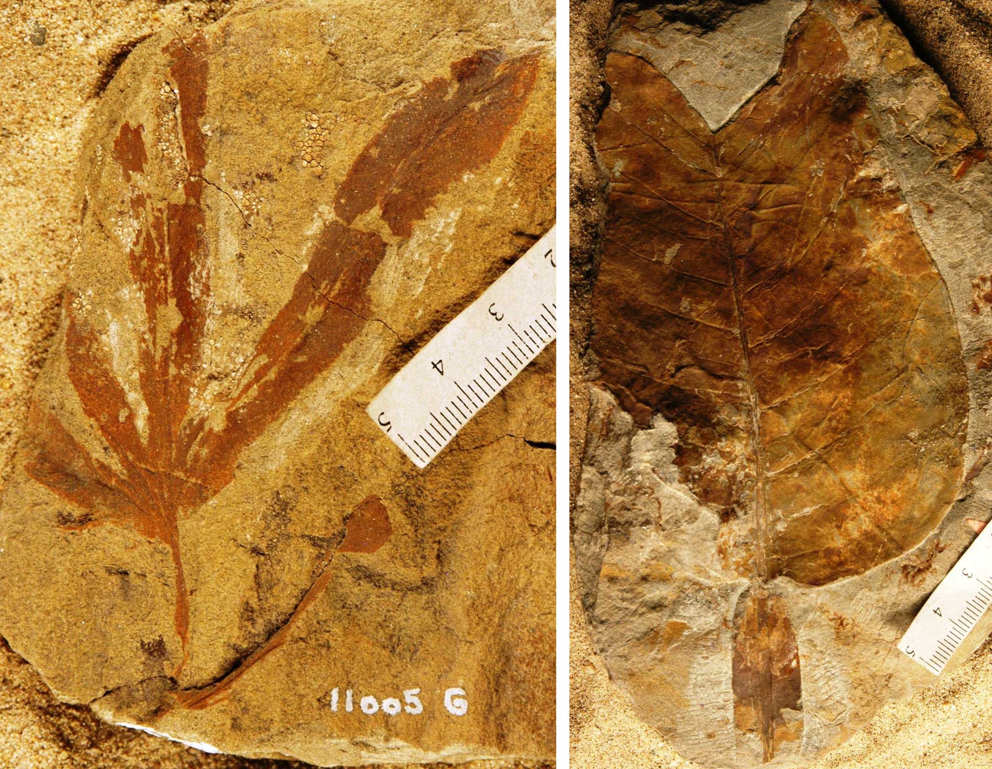
Plant fossils from the Late Cretaceous, Raton Basin, Huerfano County, Colorado. Left: Portion of a leaf of a climbing fern (Lygodium spatulatum). Photo of YPM PB 023925 by Division of Paleobotany, Yale Peabody Museum, 2015 (CC0 1.0 Universal/Public Domain Dedication, accessed via GBIF.org). Right: Leaf of a tulip poplar (Liriodendron alatum). Photo of YPM PB 023925 by Division of Paleobotany, Yale Peabody Museum, 2015 (CC0 1.0 Universal/Public Domain Dedication, accessed via GBIF.org).
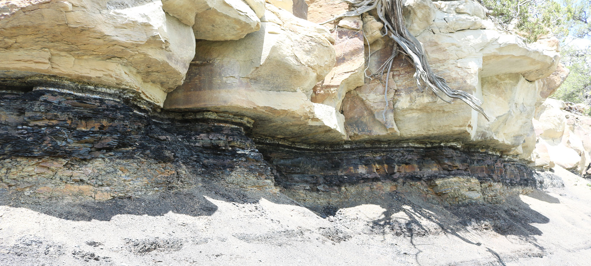
The Cretaceous-Paleogene boundary at Trinidad Lake State Park, Las Animas County, Colorado. Photo by Jeffrey Beall (Wikimedia Commons, Creative Commons Attribution 4.0 International license, image resized).
Cenozoic fossils
Paleogene fossils
Paleocene Castle Rock flora
At Castle Rock, on the margin of the Denver Basin, is a very high-diversity assemblage of fossil leaves. The Castle Rock plant fossils appear to represent the oldest known tropical rainforest, in existence just 1.4 million years after the end-Cretaceous mass extinction.
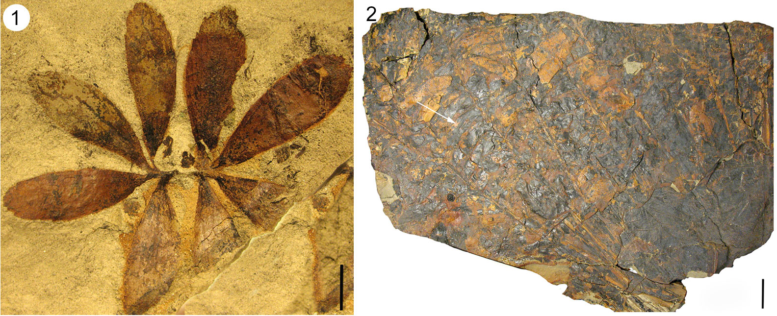
Fossils of a cycad (Dioonopsis praespinulosa) from the Paleocene Castle Rock Flora, Colorado. Cycads are a group of seed plants that look superficially similar to palms, but are not closely related to them and do not produce flowers. Left (1): Leaves of a seedling. Scale bar = 1 centimeter (about 0.4 inches). Right (2): Crown of leaves from a mature plant. The white arrow is pointing to one of the leaflets of a compound leaf. Scale bar = 5 centimeters (about 2 inches). Source: Figure 1 from Erdei et al. (2019) Biology Letters 15: 20190114 (Creative Commons Attribution 4.0 International license, images cropped, reconfigured, resized, and relabeled).
Eocene to Oligocene fossils
In the northeastern part of Colorado, exposures of the White River Group, which is probably best known from the White River Badlands of South Dakota, yield some fossil vertebrates that are late Eocene to Oligocene in age. These include rhinoceroses, entelodonts ("hell pigs"), and birds.
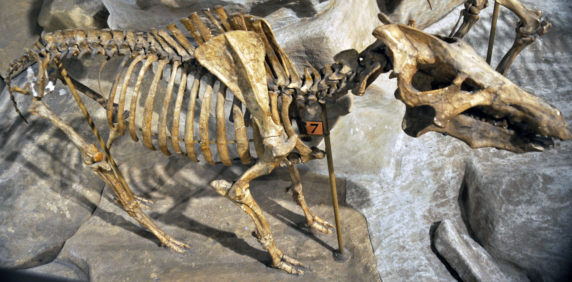
A rhinoceros (Trigonias osbornii) from the Eocene to Oligocene Chadron Formation (White River Group), Weld County, Colorado. Photo of USNM V 12724 by Michael Brett-Surman (Smithsonian National Museum of Natural History, public domain).
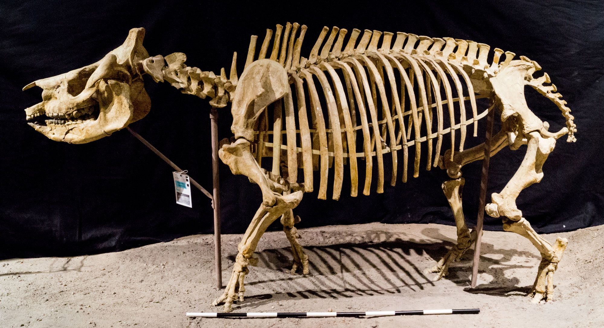
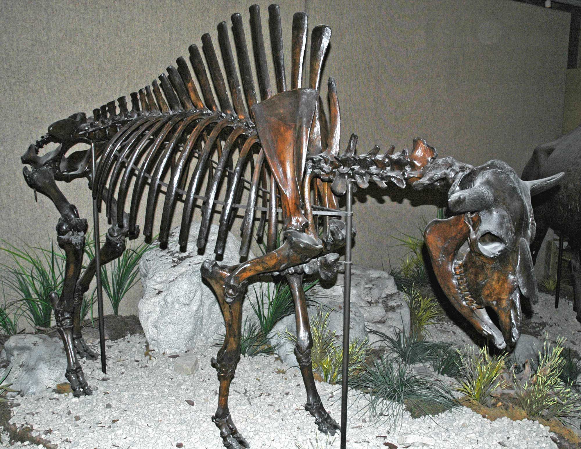
Skeleton of a hell pig (Archaeotherium mortoni) from the Oligocene of Colorado (location not specified). Specimen on display at the Carnegie Museum of Natural History, Pittsburgh, Pennsylvania. Photo by James St. John (flickr, Creative Commons Attribution 2.0 Generic license, image resized).
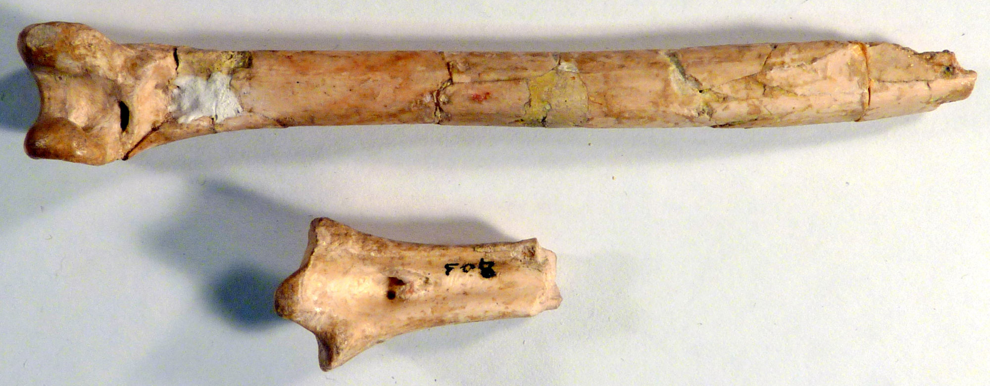
Bones of a New World vulture (Palaeogyps prodromus), Eocene to Oligocene Chadron Foramtion (White River Group), Weld County, Colorado. Photo of USNM V 11715 by Michael Brett-Surman (Smithsonian National Museum of Natural History, public domain).
Quaternary fossils
Like other places across the United States, the Great Plains region of the southwestern U.S. yields fossils of Pleistocene ("Ice Age") animals like mammoths. Several well-known late Pleistocene to early Holocene archaeological sites in North America that include large mammal remains are in eastern New Mexico. (Archaeology differs from paleontology in that archaeologists study evidence of ancient humans and their cultures, whereas paleontologists study remains and traces of ancient organisms.)
The Folsom site was first discovered in 1908 by George McJunkin, a cowboy and amateur naturalist. McJunkin recognized that bones eroding out of a bank were those of an extinct bison, which was later identified as Bison antiquus. In the 1920s, a team from the natural history museum in Denver, Colorado, traveled to the Folsom Site to retrieve the bison bones for an exhibit. While excavating, they discovered stone spear points among the bones.
The Blackwater Draw Site is located near Clovis, New Mexico. It was first discovered and excavated in the late 1920s to early 1930s. During excavation, spear points were found among mammoth bones. Similar spear points were also found with mammoth bones at the Dent Site in Weld County, Colorado, at about the same time (for a photo of the mammoth skeleton from the Dent Site, see the header image on this page).
When they were discovered, these sites indicate that humans had inhabited North America for far longer than previously thought. Folsom and Clovis are now names for the styles of spear point found at the Folsom and Blackwater Draw (Clovis) sites, respectively. These types of spear points have also been discovered elsewhere in North America. Clovis points were made in the late Pleistocene (13,500 to 12,900 years ago), whereas Folsom points are slightly younger. The Blackwater Draw Site is a National Historic Landmark.
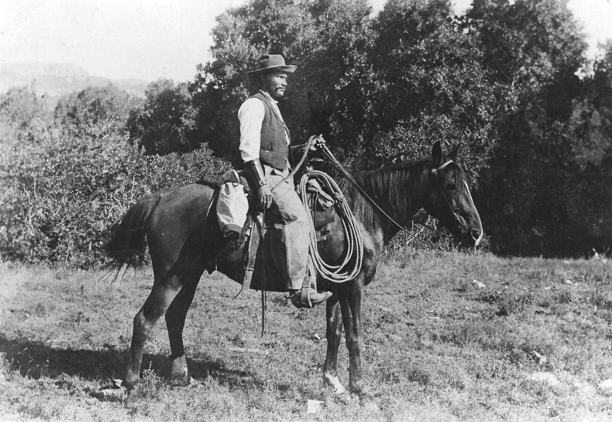
George McJunkin, discoverer of the Folsom Site, picture thought to have been taken around 1907. McJunkin was born enslaved in Texas and moved to New Mexico, where he worked as a cowboy, following the Civil War. Photo author unknown (Wikimedia Commons, public domain).
Extinct bison (Bison antiquus) found near Folsom, New Mexico. Skeleton on display at the Carnegie Museum of Natural History, Pittsburgh, Pennsylvania. Photo by James St. John (flickr, Creative Commons Attribution 2.0 Generic license, image resized).

Drawings of Clovis and Folsom points. Left drawing and right drawing by HFC ArtMedium (National Park Service, public domain).
An exhibit recreating an excavation at the Blackwater Draw National Historic Landmark between Clovis and Portales, New Mexico. Photo by Sue Ruth (flickr, Creative Commons Attribution 2.0 Generic license, image cropped).
Resources
Resources from the Paleontological Research Institution & partners
Cretaceous Atlas of Ancient Life, Western Interior Seaway (Colorado, Iowa, Kansas, Montana, Nebraska, New Mexico, North Dakota, Oklahoma, South Dakota, Texas, Utah, Wyoming): https://www.cretaceousatlas.org/geology/
Digital Atlas of Ancient Life Virtual Collection: https://www.digitalatlasofancientlife.org/vc/ (Virtual fossil collection featuring 3D models of fossil specimens sorted by group)
Digital Encyclopedia of Ancient Life: https://www.digitalatlasofancientlife.org/learn/
Earth@Home: Earth Science of the South-central United States: Fossils of the Basin and Range (more about fossils from the Permian reef complex in southeastern New Mexico and western Texas): https://earthathome.org/hoe/sc/fossils-br/
Earth@Home: Earth Science of the South-central United States: Fossils of the Great Plains (includes more about fossils from the Western Interior Seaway in western Kansas, Oklahoma, and Texas): https://earthathome.org/hoe/sc/fossils-gp/
Earth@Home: Earth Science of the Northwest-central United States: Fossils of the Great Plains (includes more about fossils Montana, Nebraska, North Dakota, South Dakota, and Wyoming): https://earthathome.org/hoe/sc/fossils-gp/
Earth@Home: Quick guide to common fossils: https://earthathome.org/quick-faqs/quick-guide-common-fossils/