

Page snapshot: Introduction to the climate of Alaska, including present, past, and future climate.
Topics covered on this page: Present climate of Alaska.; Present temperature; Present precipitation; Severe weather; Regional climate variation; Past climate of Alaska; Paleozoic; Mesozoic; Cenozoic; Future climate of Alaska; Resources.
Credits: Most of the text of this page comes from "Climate of the Western US" by Ingrid H. H. Zabel, Judith T. Parrish, Alexandra Moore, and Gary Lewis, chapter 9 The Teacher-Friendly Guide to the Geology of the Western US, edited by Mark D. Lucas, Robert M. Ross, and Andrielle N. Swaby (published in 2014 by the Paleontological Research Institution; currently out of print). The book was adapted for the web by Elizabeth J. Hermsen, Jonathan R. Hendricks, and Ingrid Zabel in 2022. Changes include formatting and revisions to the text and images. Credits for individual images are given in figure captions.
Updates: Page last updated June 8, 2022.
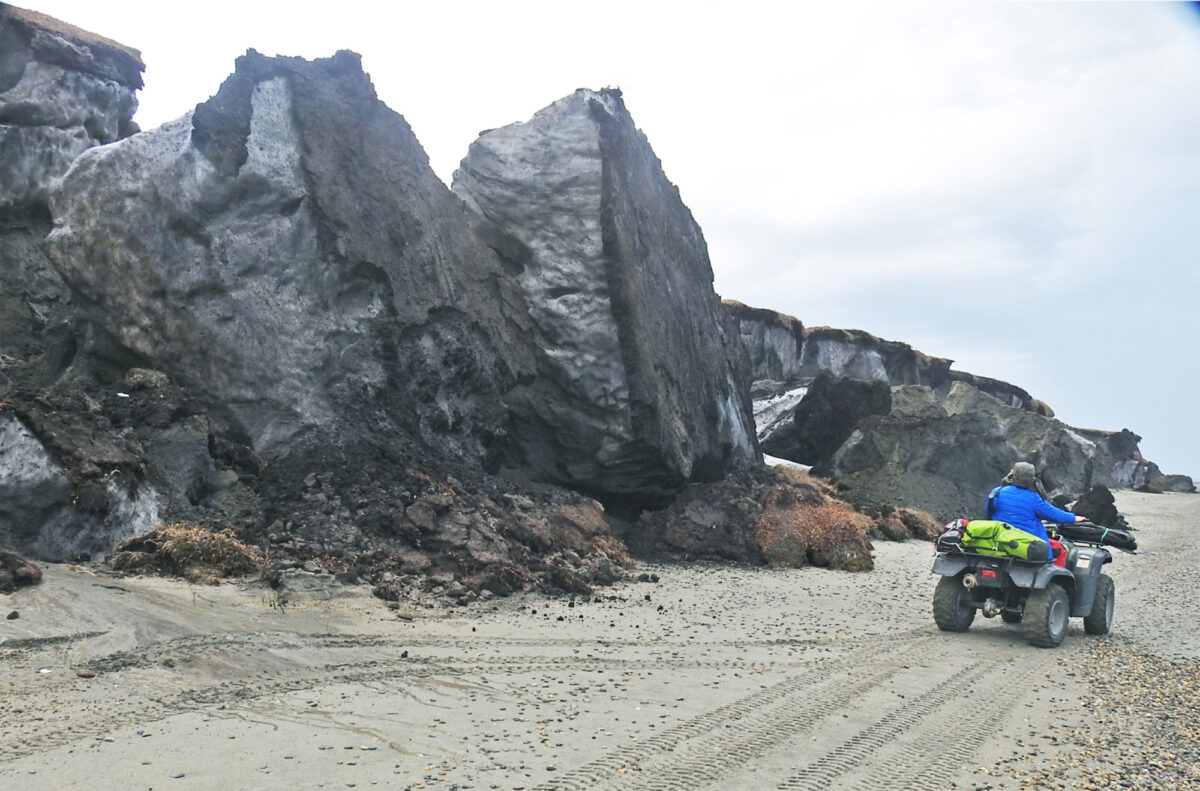
Image above: Eroding permafrost bluffs on the coast of Barter Island, an island in the Beaufort Sea, northern Alaska. Source: USGS (public domain).
Present climate of Alaska
Because of its wide latitudinal range and the proximity of the Pacific Ocean, Alaska has a variety of climatic areas. These range from rainforests in the Alexander Archipelago to tundra in Alaska’s far north.
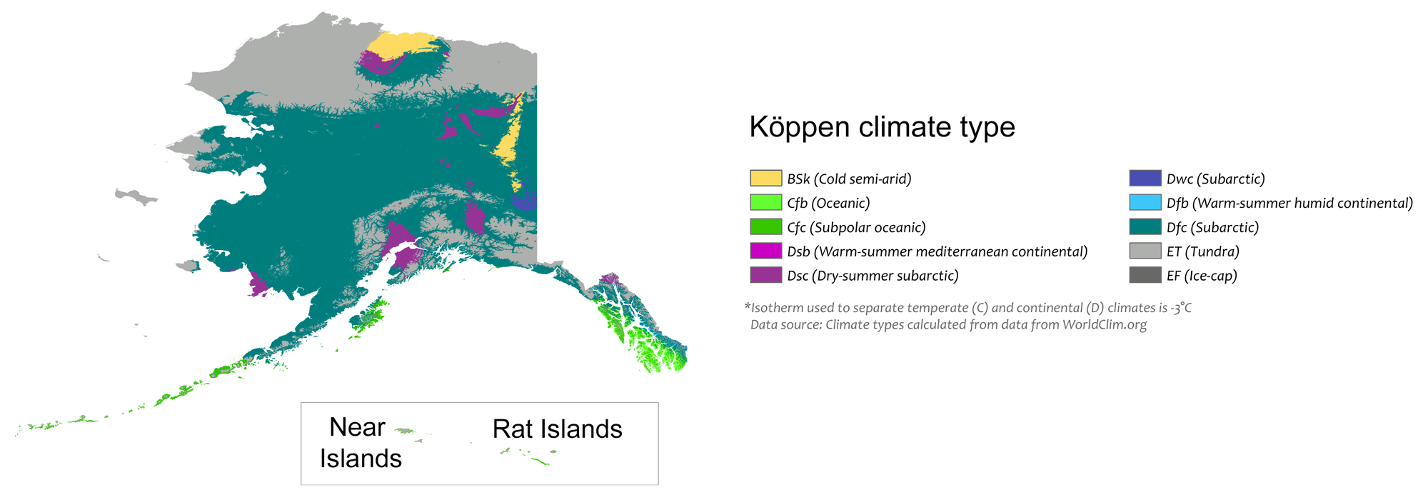
Köppen map of the Alaska. The inset shows the Near Islands, the Rat Islands, and the small Buldir Island that occurs between them in the westernmost Aleutian Islands (the island chain stretching to the west of mainland Alaska) The first letter of each zone in the key indicates its major classifcation. B = Arid, C = Temperate (warm temperate), D = Cold (continental), E = polar. Modified from a map by Adam Peterson (Wikimedia Commons, Creative Commons Attribution-ShareAlike 4.0 International license).
Alaska’s climate is influenced by its mountain ranges and its proximity to the ocean. Statewide averages range from a low of -20°C (-4°F) in January to a high of 11°C (52°F) in July. North of the Brooks Range, Alaska has a cold, dry, polar climate with frequent winter blizzards. Temperatures on the coast are moderated somewhat by the Arctic Ocean. Central Alaska has a dry continental climate, with a large variation between summer and winter temperatures. For example, the town of Takotna in Alaska’s interior has an average low temperature of -27°C (-17°F) in January and an average high of 22°C (72°F) in July. Heat records have been broken in recent years, such as when the city of Anchorage, AK reported a temperature of 90°F (32.2°C) on July 4, 2019, and a weather station on Kodiak Island recorded a temperature of 67°F (19.4°C) on December 26, 2021.
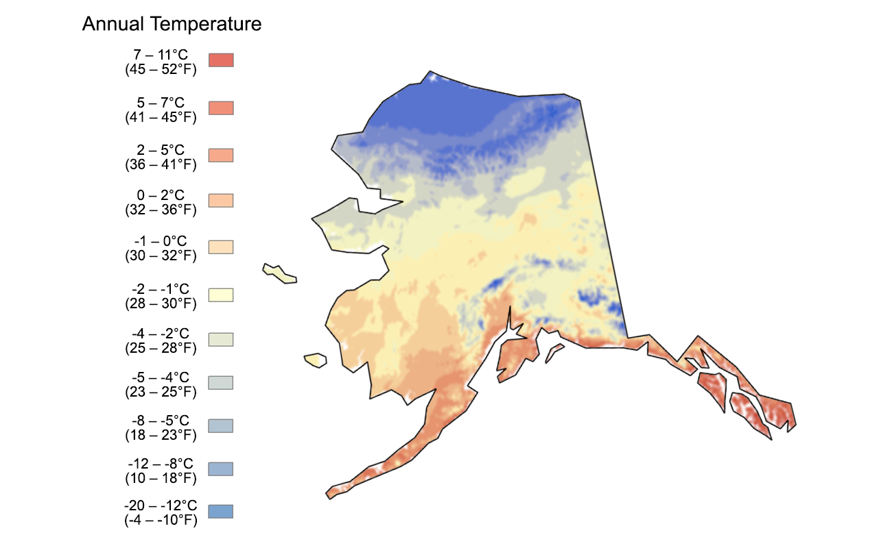
Mean annual temperature for Alaska. Image adapted from an image by Scenarios for Climate Assessment and Adaptation, first published in The Teacher-Friendly Guide to the Earth Science of the Western US.
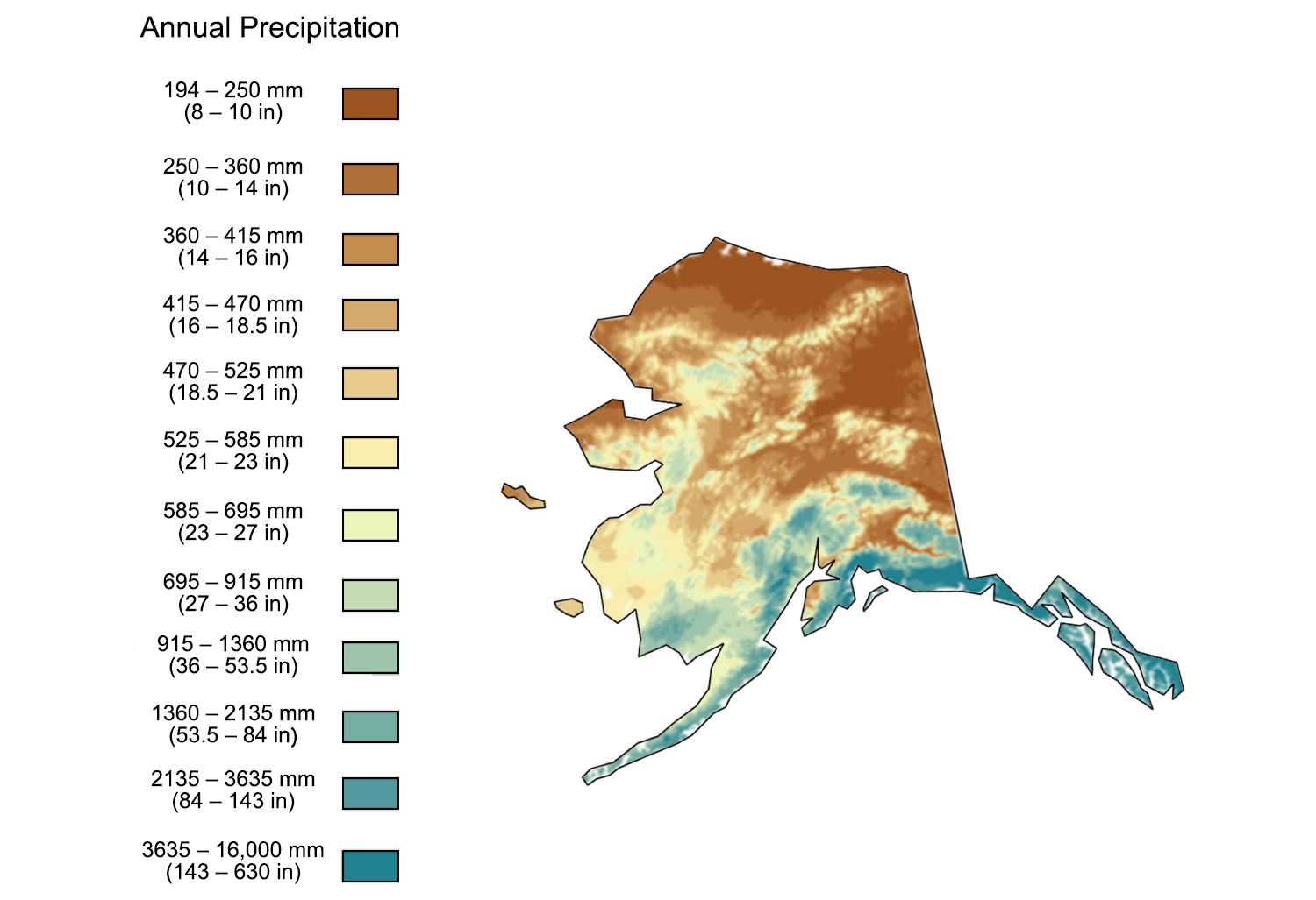
Mean annual precipitation for Alaska. Image adapted from an image by Scenarios for Climate Assessment and Adaptation, first published in The Teacher-Friendly Guide to the Earth Science of the Western US.
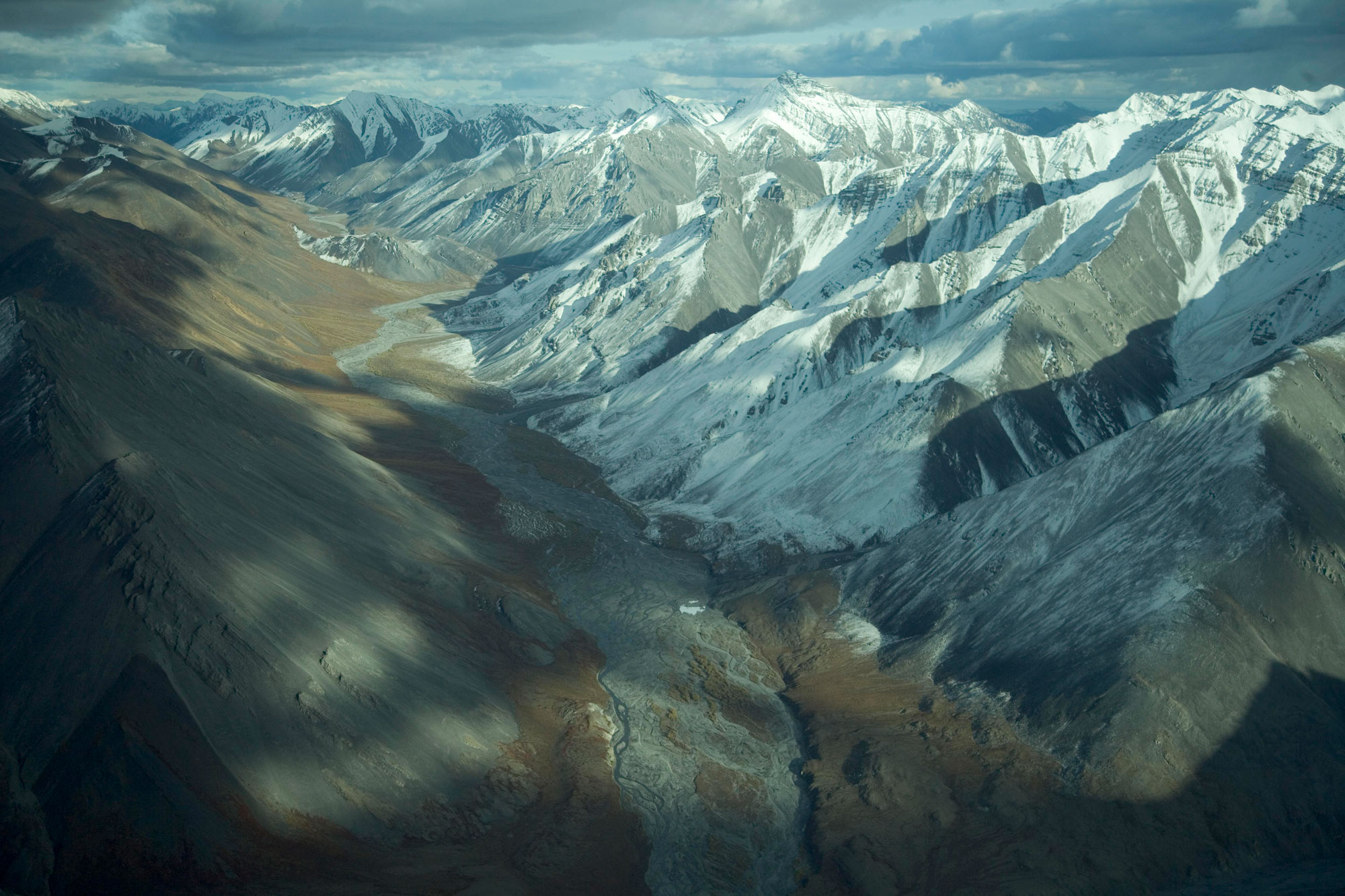
Mountains of the Brooks Range in the Arctic National Wildlife Refuge, northeastern Alaska. Photo by Hillebrand/USFWS (Alaska Region U.S. Fish & Wildlife Service on flickr, public domain).
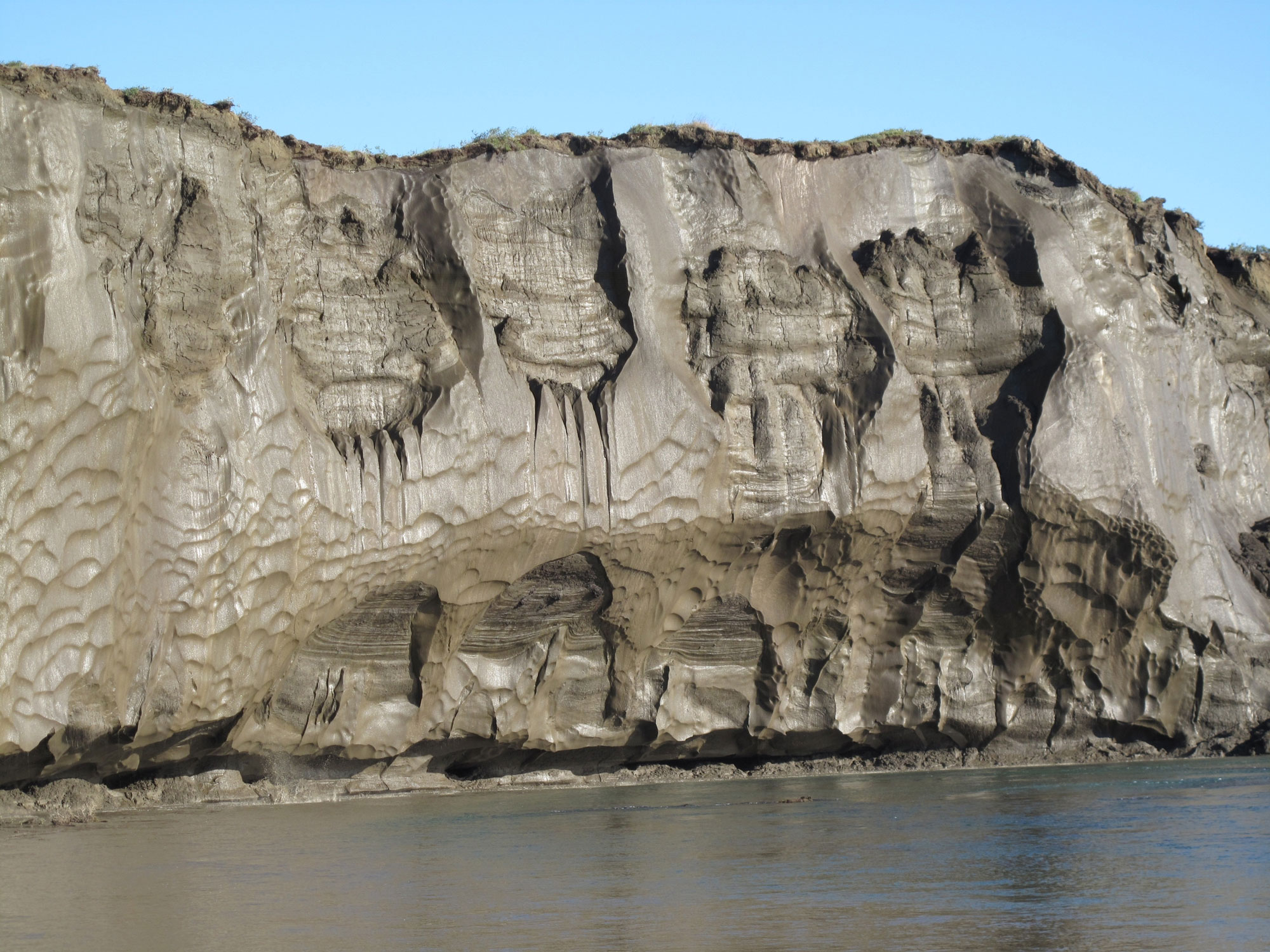
An exposed permafrost bank on the Itkillik River, northern Alaska. Photo by Mikhail Kanevskiy, University of Alaska Fairbanks, Institute of Northern Engineering (USGS, public domain).
Another climate area exists in the Alaskan southeast, south coast, and southwestern islands, and in west-central Alaska in the summer. These areas have moderate temperatures and high precipitation; average annual temperature is about 7°C (45°F). Some areas are home to lush rainforests and receive around 500 centimeters (200 inches) of rain a year.
The climate in west-central Alaska is influenced by a phenomenon that is unique in the United States: the seasonal presence of sea ice. In the winter when sea ice covers the Bering Sea, this area loses the moderating effect of open water and has a continental climate. When the sea ice melts in summer, the climate returns to a warmer, more humid maritime state.
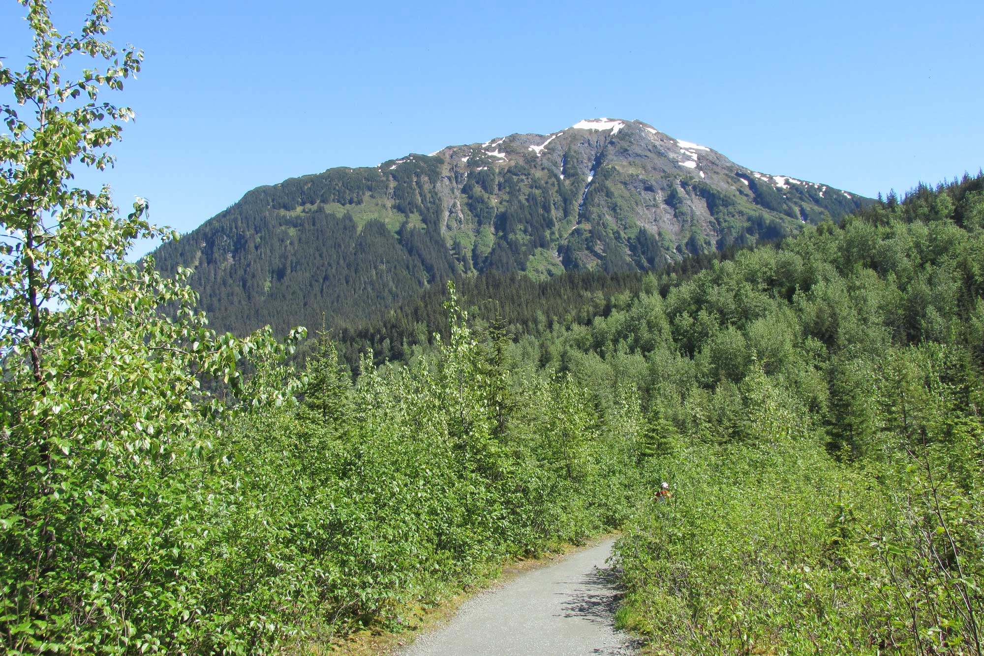
Tongass National Forest near Juneau, southeast Alaska. Photo by Larry Syverson (flickr, Creative Commons Attribution-ShareAlike 2.0 Generic license, image resized).
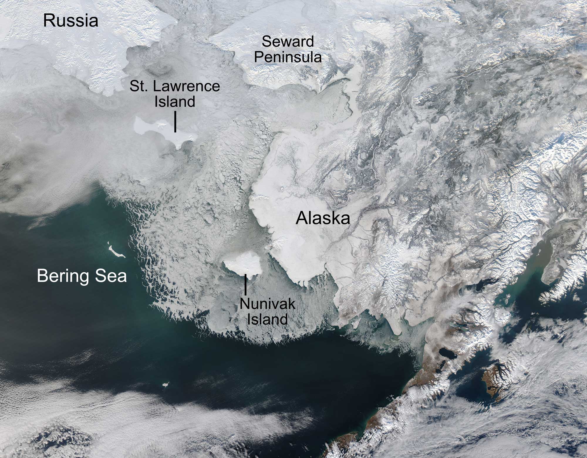
Satellite image showing season sea ice on the Bering Sea between eastern Russia and western Alaska. This image is from February 4, 2014. Photo by NASA/GSFC/Jeff Schmaltz/MODIS Land Rapid Response Team (NASA Goddard Space Flight Center on flickr, used following NASA's image use policy).
Past climate of Alaska
This section covers the climate of Alaska through the Phanerozoic, from about 541 million years ago to the recent. For the climate on early Earth prior to 541 million years ago, see the Introduction to Climate section.
Paleozoic (541 to 252 million years ago)
Alaska is almost entirely composed of ancient terranes and volcanic island arcs that drifted together at different times during Earth’s history and had not assembled into anything resembling modern Alaska until the Jurassic. Most of these terranes appear to have experienced warm, wet climates, and geologists have concluded that they all originated in tropical areas of what is now the Pacific Ocean.
Alaska’s Cambrian- through Silurian-age rocks all formed on these tropical microcontinents. Devonian rocks are common in northern Alaska. These rocks include carbonate platforms, which are consistent with a low-latitude position and warm climate. Carboniferous and Permian rocks in Alaska originated on tropical terranes. Some contain lush, tropical floras that are completely dissimilar to those on the main part of the continent, a testament to their continued isolation in the ocean far from the North America, which had now become part of the supercontinent Pangaea. Carboniferous rocks in northern Alaska contain extensive carbonate platforms, which are indicative of a warm climate. Alaska’s Permian rocks are also indicative of a marine environment.
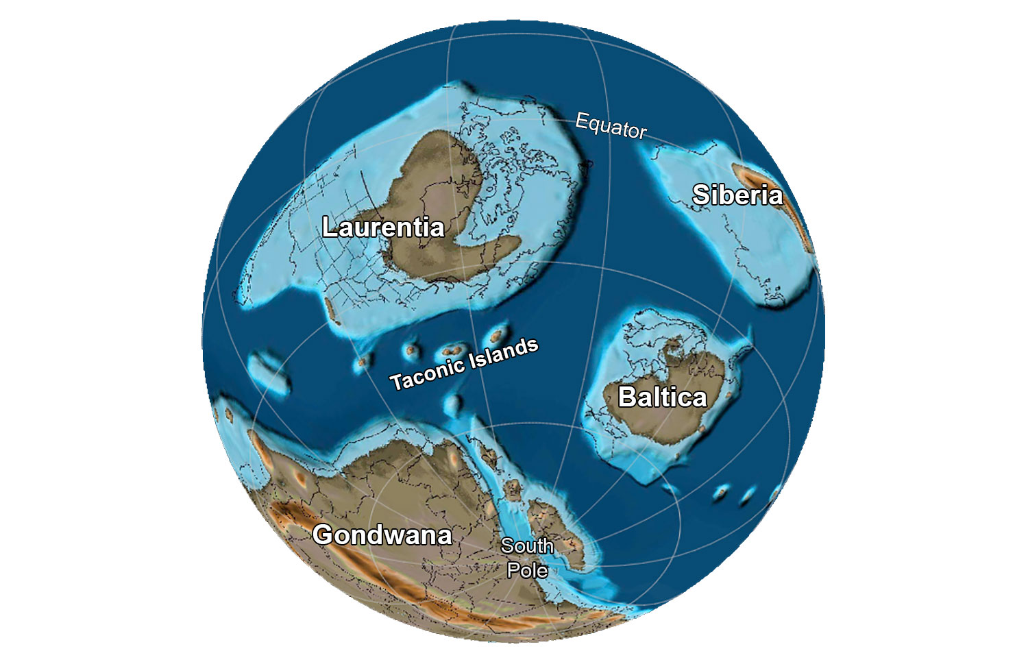
The globe about 485 million years ago, near the Cambrian-Ordovician boundary. Reconstruction created using basemap from the PALEOMAP PaleoAtlas for GPlates and the PaleoData Plotter Program, PALEOMAP Project by C. R. Scotese (2016); map annotations by Jonathan R. Hendricks for PRI's Earth@Home project (CC BY-NC-SA 4.0 license).
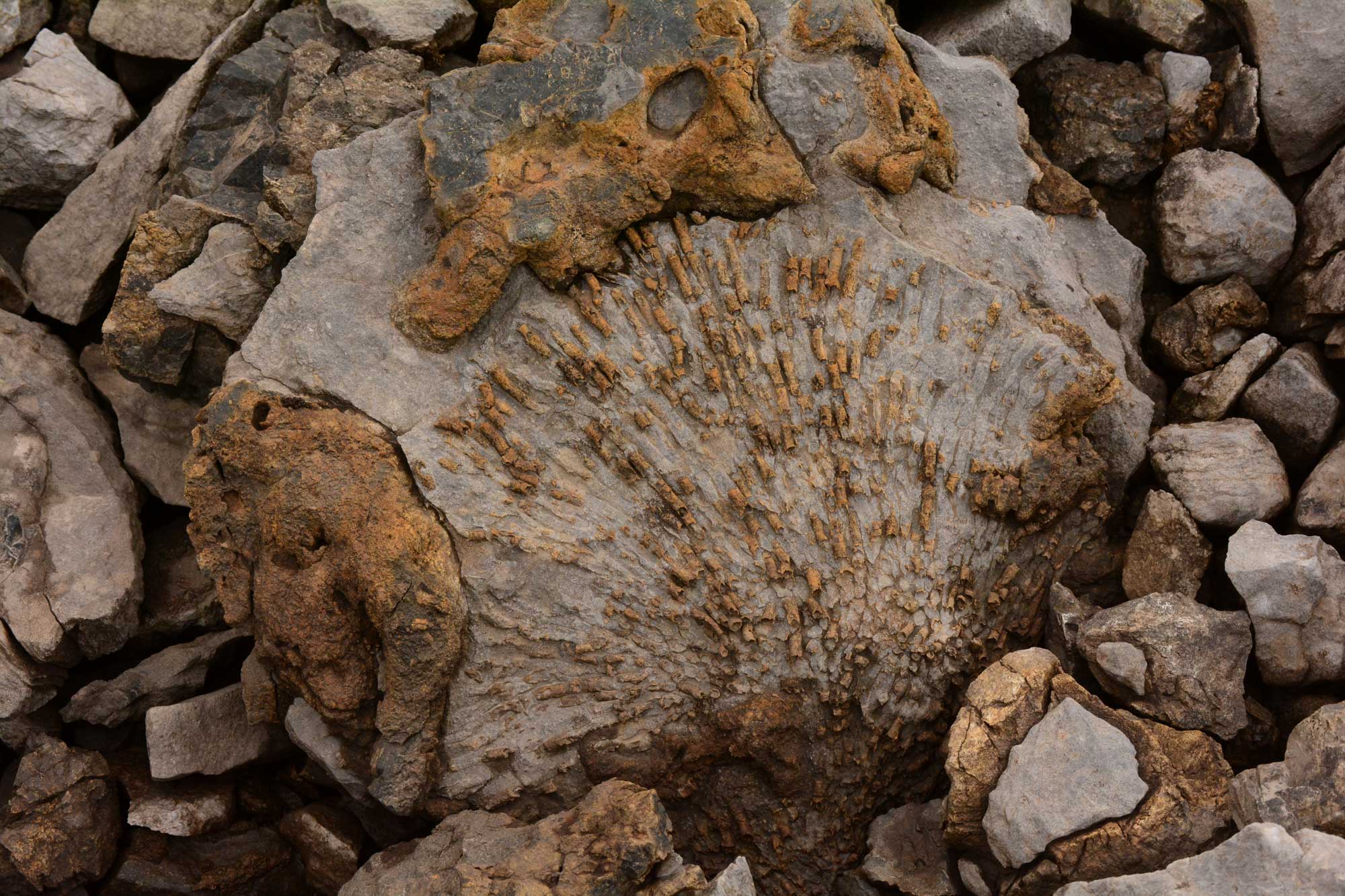
Fossil coral (Paleozoic, exact age unknown), Brooks Range, Alaska. Photo by Paxson Woelber (Wikimedia Commons, Creative Commons Attribution-ShareAlike 3.0 Unported license, image resized).
Mesozoic (252 to 66 million years ago)
Triassic to Jurassic (252 to 145 million years ago)
In the Triassic, around 220 million years ago, Pangaea, a supercontinent composed of nearly all the landmass on Earth, began breaking up into continents that would drift toward their modern-day positions. Island arcs formed close to what is now southern Alaska, where a very productive sea flooded the Triassic continental margin. Much of southern Alaska was assembled during the Jurassic as a series of island arcs and terranes collided with northern Alaska, which had now drifted into its current position and existed as a broad, flat shelf of shallow marine rocks. The Earth remained warm until worldwide temperatures began to dip again during the Late Jurassic, around 150 million years ago.
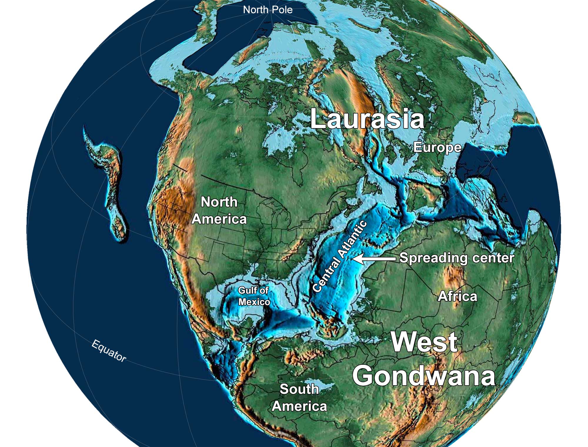
Earth 150 million years ago, near the end of the Jurassic Period. North America and Europe are part of Laurasia, and South America and Africa are part of Gondwana. Notice that North America has separated from Africa and there is a spreading center in the Central Atlantic Ocean. Reconstruction created using Paleomap (by C. Scotese) for GPlates. Reconstruction created using basemap from the PALEOMAP PaleoAtlas for GPlates and the PaleoData Plotter Program, PALEOMAP Project by C. R. Scotese (2016); map annotations by Jonathan R. Hendricks and Elizabeth J. Hermsen for PRI's Earth@Home project (CC BY-NC-SA 4.0 license).
3D model of a ammonite (Emileia constricta), Jurassic Tuxedni Group, Lake Clark National Park and Preserve, Alaska. Width = 4 centimeters (about 2 inches). Source: Alaska National Parks Geology on Sketchfab (Creative Common Attribution 4.0 International license).
Cretaceous (145 to 66 million years ago)
As a result of displacement due to continental rifting and seafloor spreading, sea level throughout the Cretaceous was much higher than it is today. Global temperatures during the Cretaceous were very warm, as much as 10°C (18°F) above those at present. There was likely little or no glacial ice anywhere on Earth, and temperatures were highest in lower latitudes. Shallow seaways spread over many of the continents, including South America, Africa, Eurasia, and North America.
The Earth warmed near the beginning of the Cretaceous, and sea level rose. Even though Alaska was closer to the North Pole than it is at present, fossil vegetation indicates that its climate was very similar to that of western Oregon today. Lush swamps and forests occupied lowland areas; some of these swamps have become rich coal beds. The climate cooled again at the end of the Cretaceous, 65 million years ago. This cooling had the greatest impact on northern Alaska, where fossilized forests resemble those found near Anchorage today.
Plant fossils from the Late Cretaceous, Denali National Park, Alaska. Leaves labeled on the specimen include a cycad, a dawn redwood (Metasequoia), a laurel-like plant, and an ancient sycamore. Source: Denali National Park and Preserve on Sketchfab (Creative Common Attribution-NonCommercial-NoDerivs license).
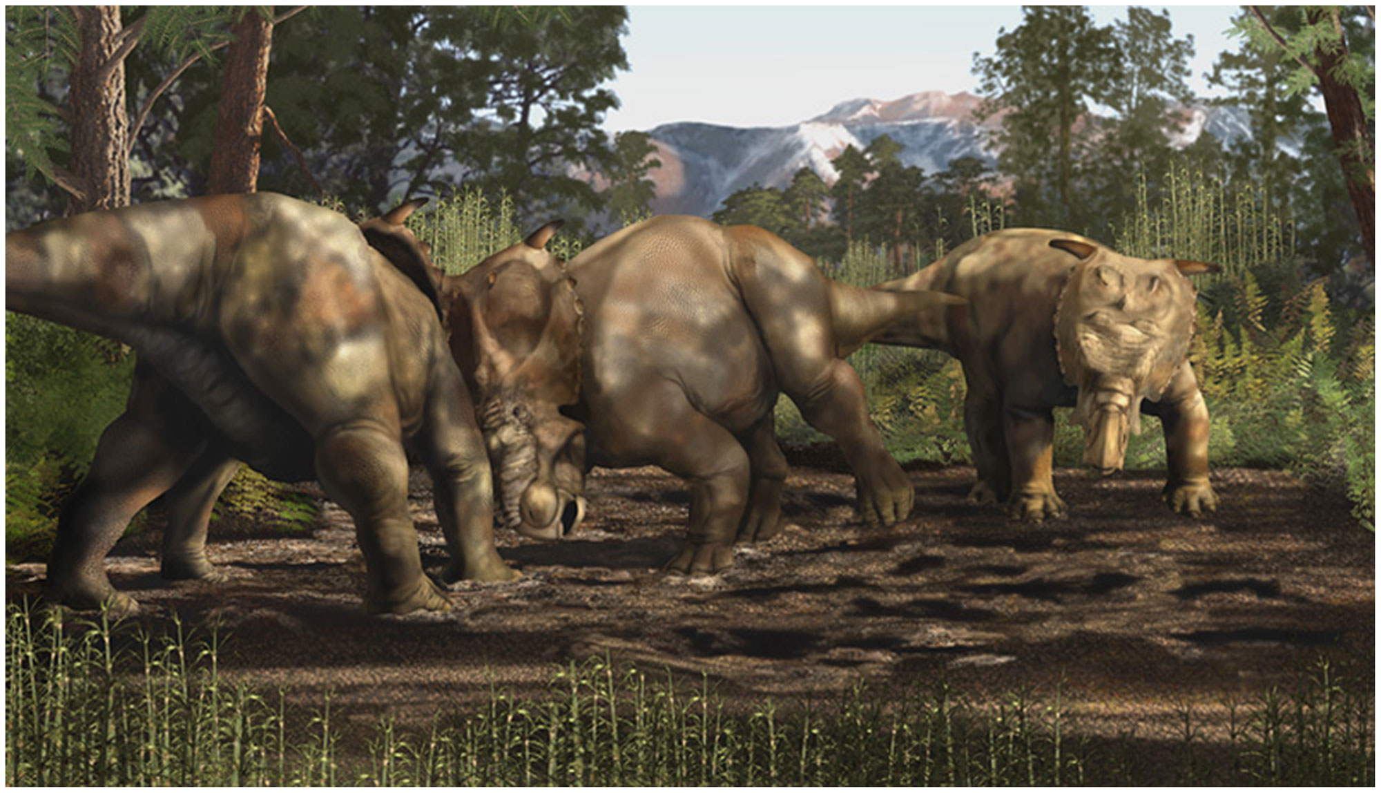
Reconstruction of Pachyrhinosaurus perotorum in the Late Cretaceous of Alaska's North Slope. Reconstruction by K. Carr. Source: Fiorillo & Tykoski (2013) PLoS ONE 8(6): e65802 (Creative Commons Attribution License).
Cenozoic (66 million years ago to present)
Paleogene to Neogene (66 to 2.6 million years ago)
In the early Paleogene, the climate warmed once more. By around 50 million years ago, palm trees were growing in southern Alaska and the Alexander Archipelago. Alaska’s northern forests once again grew to resemble those of modern forests much farther south. Between 35 and 20 million years ago, however, the climate became cooler and drier, and deciduous trees such as oak, maple, and alder flourished.
Quaternary (2.6 million years ago to present)
Eventually, a sheet of sea ice formed over the Arctic, and ice sheets spread over northern Asia, Europe, and North America, signaling the start of the most recent ice age. Since 800,000 years ago, an equilibrium has been reached between warming and cooling, with the ice caps growing and retreating primarily due to the influence of astronomical forces (i.e., the combined gravitational effects of the Earth, Sun, moon, and planets).
During the last glacial maximum, ice reached as far south as the northern part of Washington State on the West Coast of North America. While ice covered some of Alaska, the ice sheet did not extend into central or northern Alaska because the local climate was very dry. However, an ice cap covered the Brooks Range. During periods of ice advance, Alaska was colder than it is today, with extensive mountain glaciers occurring throughout the state.
As in other parts of North America, Pleistocene megafauna roamed Alaska. The most iconic of these animals may have been the woolly mammoth (Mammuthus primigenius). The last woolly mammoths in Alaska (and in the United States) lived on St. Paul Island, a remote volcanic island located to the southwest of mainland Alaska; they survived there until about 5600 years ago.
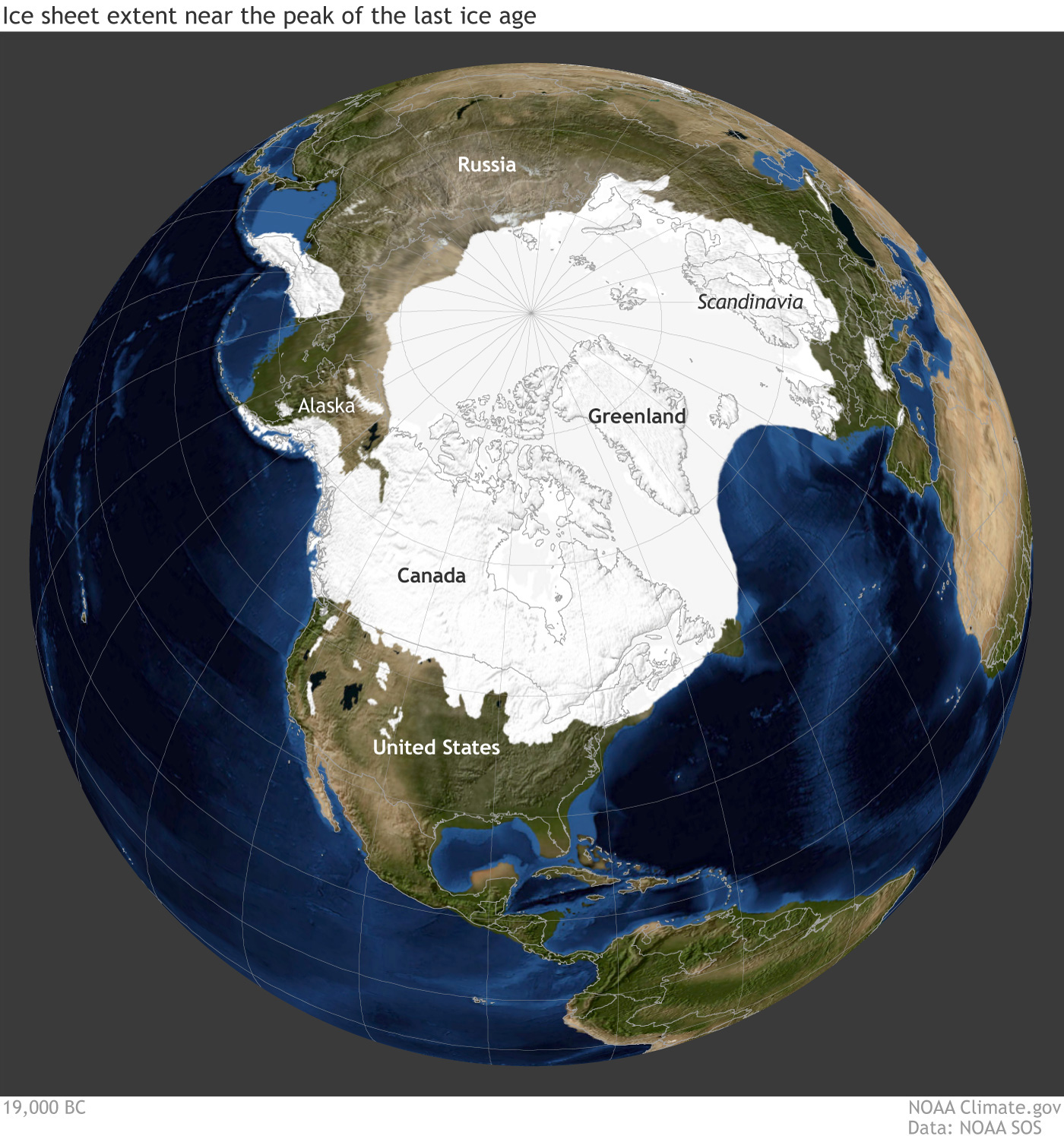
Earth during the last glacial maximum, around 20,000 years ago in the Pleistocene epoch. Much of North America was covered with a large sheet of glacial ice and the coastlines were different because sea level was lower. Reconstruction from climate.gov based on data from the University of Zurich Applied Sciences.
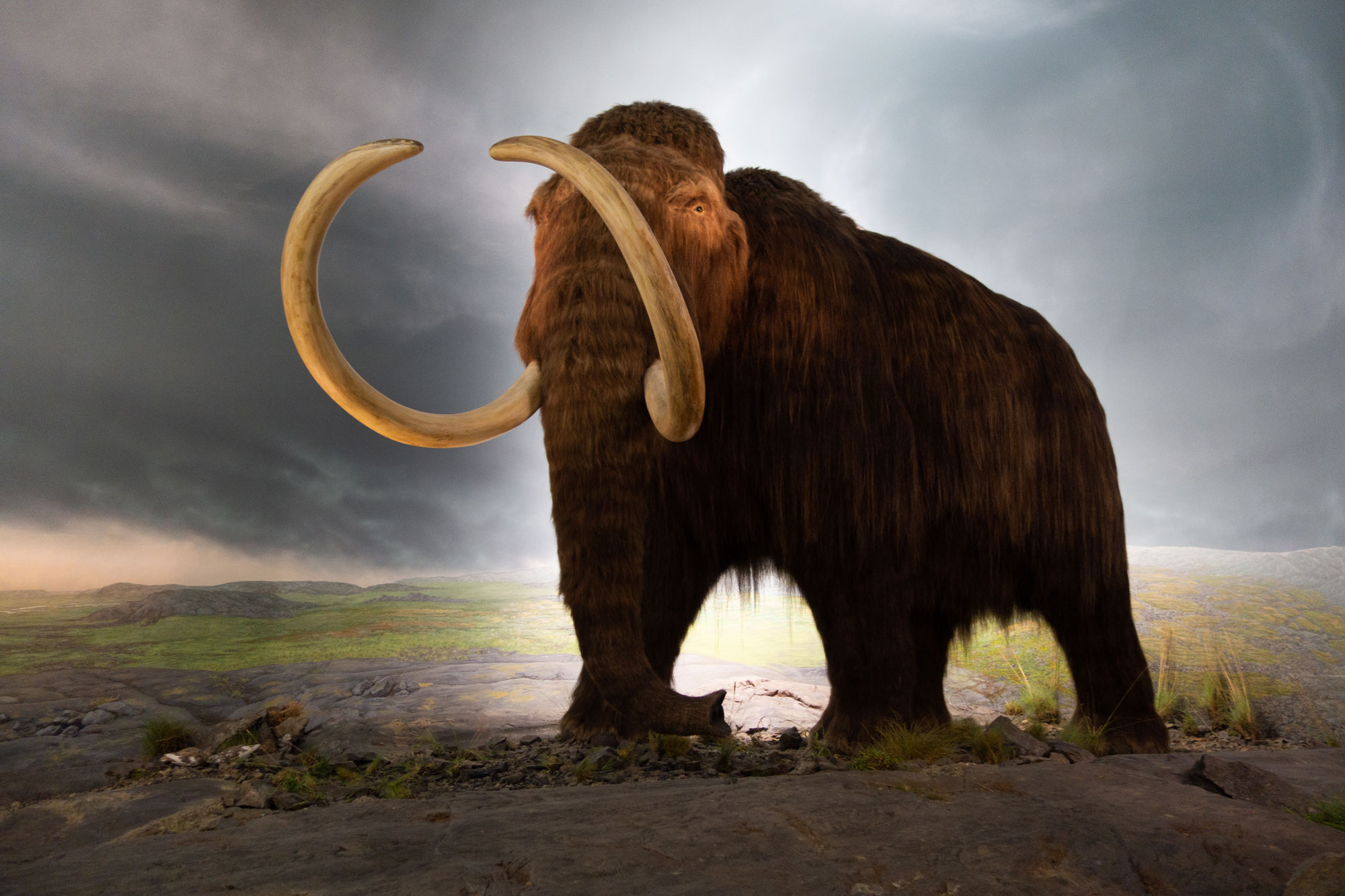
Model of a woolly mammoth on display at the Royal Victoria Museum, British Columbia, Canada. Photo by Thomas Quine (Wikimedia Commons, Creative Commons Attribution 2.0 Generic license, image resized).
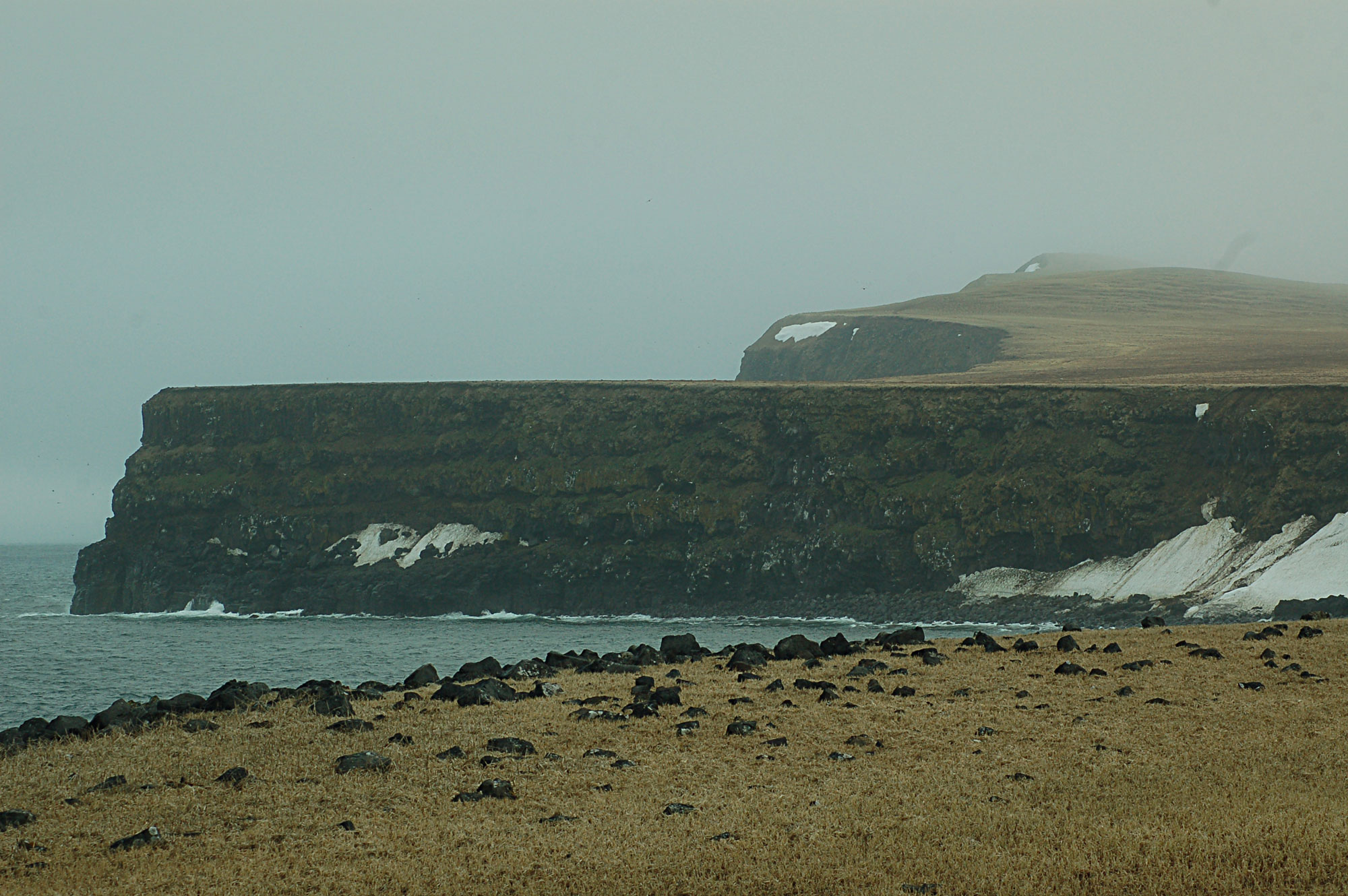
St. Paul Island, Pribilof Islands, southwestern Alaska, June 2012. This island was the last known holdout of woolly mammoths in the United States. The last known woolly mammoths in the world lived on Wrangel Island, eastern Russia, until about 4000 years ago. Photo by Don Henise (flickr, Creative Commons Attribution 2.0 Generic license, image resized).
Future climate of Alaska
Alaska contributes significantly to climate change. The population of any industrialized and particularly wealthy country produces pollution. The more than 700,000 residents of Alaska use electricity, transportation, and products that come from carbon-rich fossil fuels. Burning fossil fuels releases carbon into the atmosphere, which warms the Earth.
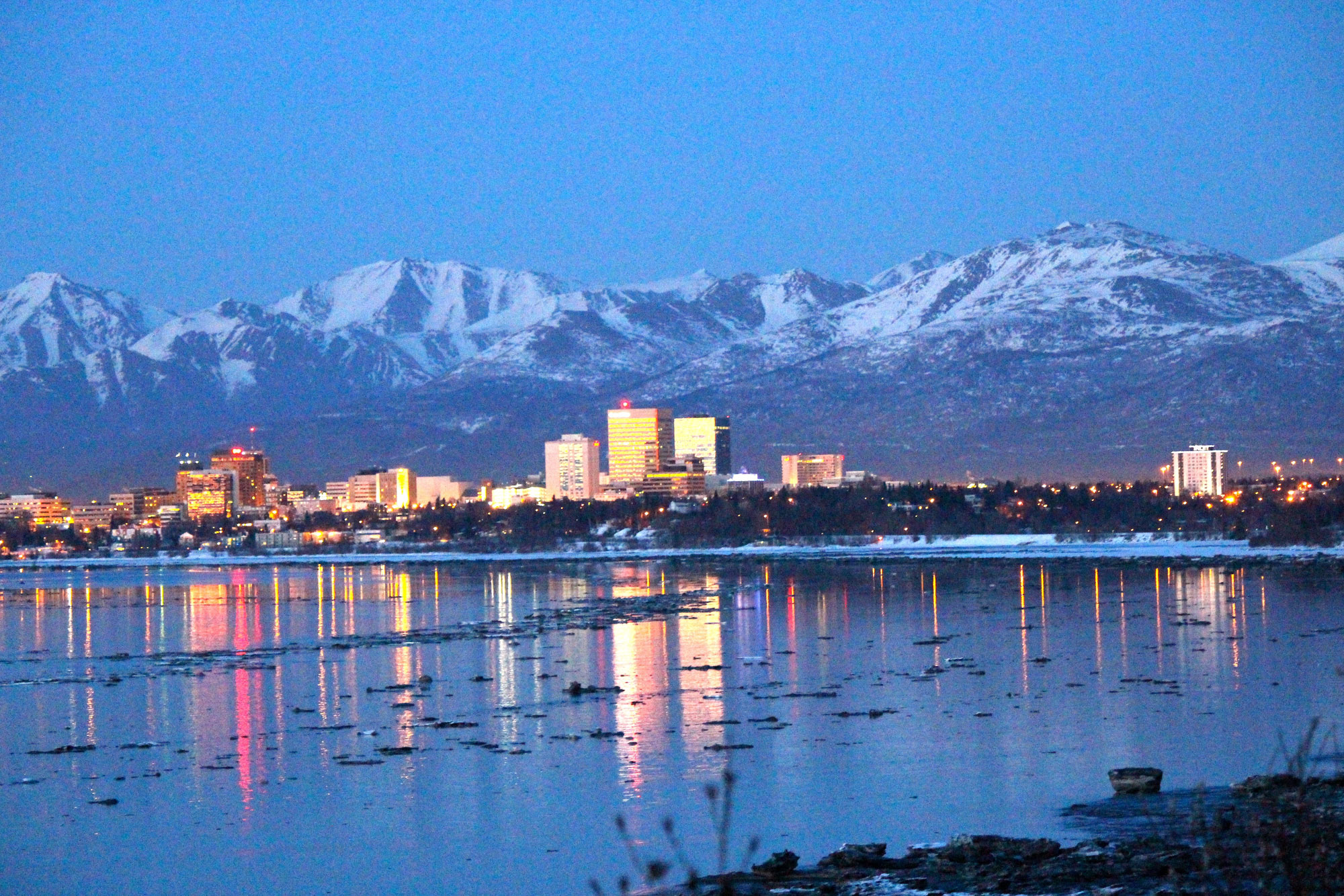
Anchorage, Alaska, in 2016. Photo by Didier Moïse (Wikimedia Commons, Creative Commons Attribution-ShareAlike 4.0 International license, image resized).
Statewide average temperatures in Alaska have increased, with winter temperatures increasing the most: up 3.2°C (5.8°F) from 1949 to 2011. Temperatures are expected to rise rapidly, by 2° to 4°C (3.5° to 7°F) by the middle of the 21st century. These increased temperatures lead to a whole host of other effects, including drier soils from more evaporation, the increased likelihood of drought and fires, and more rain (rather than snow) in the winter.
Climate models project that Alaska will receive more precipitation, but that soils will actually become drier due to increased evaporation from warmer air temperatures. Summers are expected to support a longer growing season, and also to see more drought and wildfires. Invasive insects that damage Alaskan trees will be better able to survive warmer winters and will therefore increase and spread.
Sea ice will cover the ocean for shorter portions of the year, possibly changing the distribution of plankton blooms, a part of the marine food chain upon which Alaska’s fisheries depend. Alaskan permafrost is melting, leading to dramatic changes in the coastline and landscape. In some areas, the melting permafrost and accompanying erosion have destroyed buildings and roads. Melting permafrost also releases carbon dioxide and methane when the organic material in it begins to decay, and these greenhouse gases contribute to additional warming.
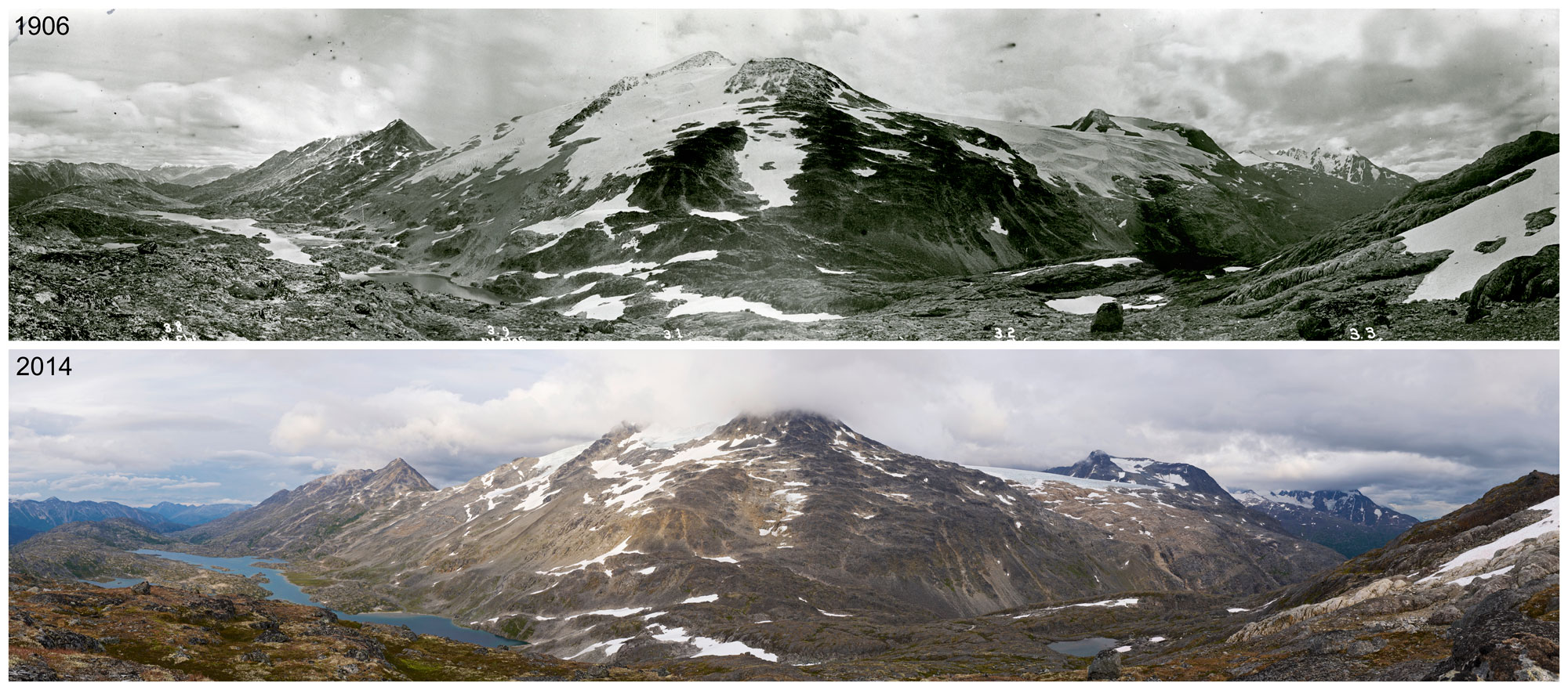
Chilkoot Pass on the Alaska-Canada border showing the retreat of glaciers. Top image is from 1906, bottom image is from 2014. Photos by George R. White-Fraser (International Boundary Commission, 1906) and Ronald D. Karpilo, Jr., and Sarah C. Venator (National Park Service, 2014). Source: NPS Climate Change Response on flickr (public domain).
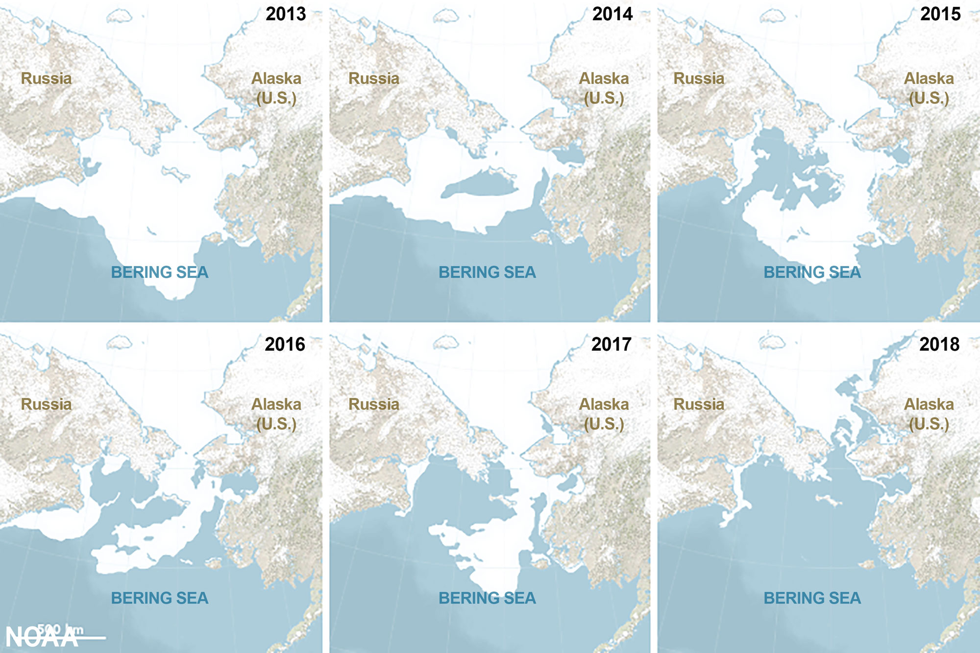
Illustrations showing the maximum extent of sea ice on the Bearing Sea from 2013 to 2018. As the climate warms, the extent of ice on the Bering Sea has been shrinking. Illustration by Joshua Stevens, NASA Earth Observatory (Source: NOAA).
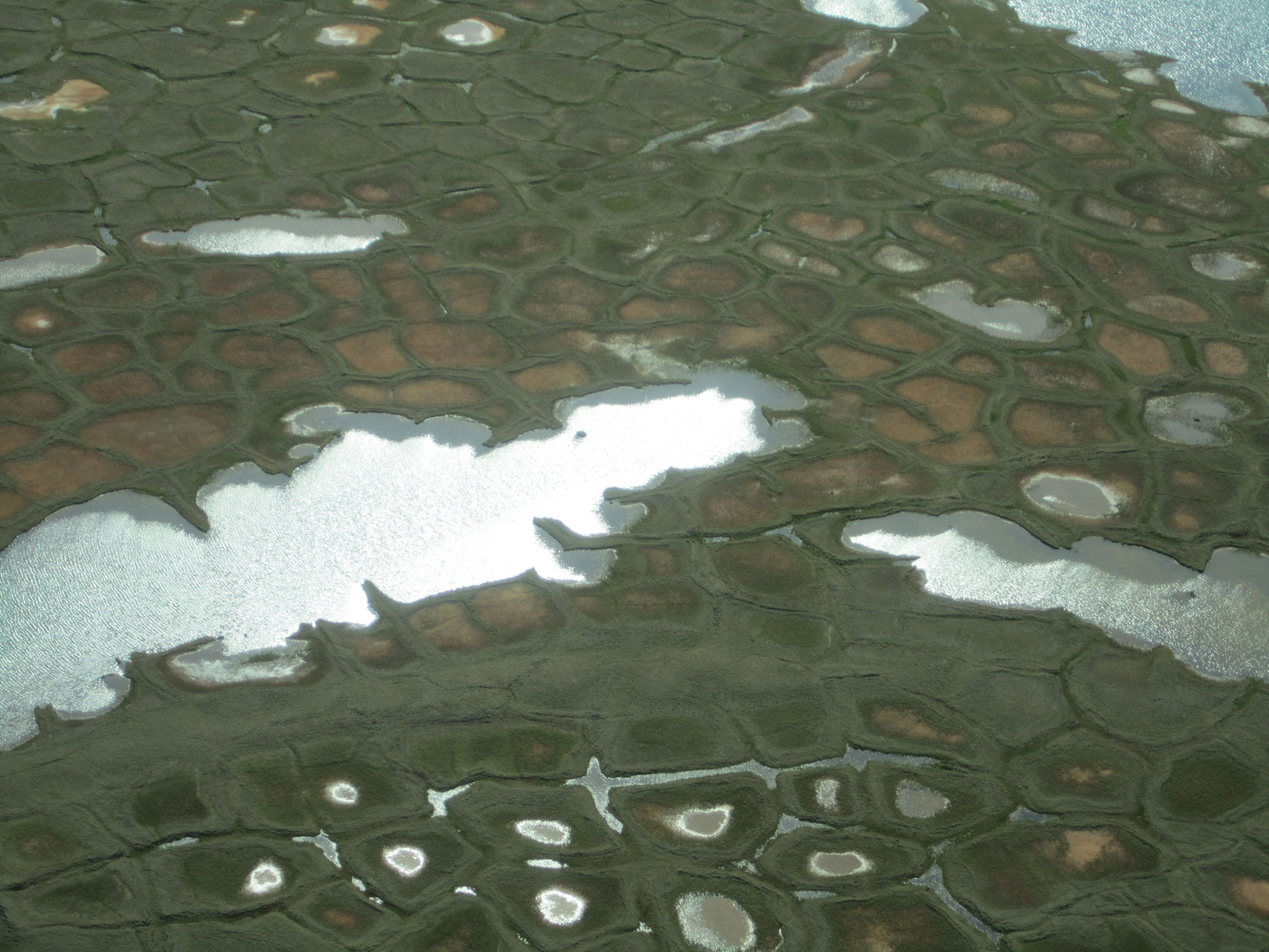
Excerpt from original caption (USGS): "Thawing ice wedges create ponds on the Arctic Coastal Plain." Photo by Joshua C. Koch (USGS, public domain).
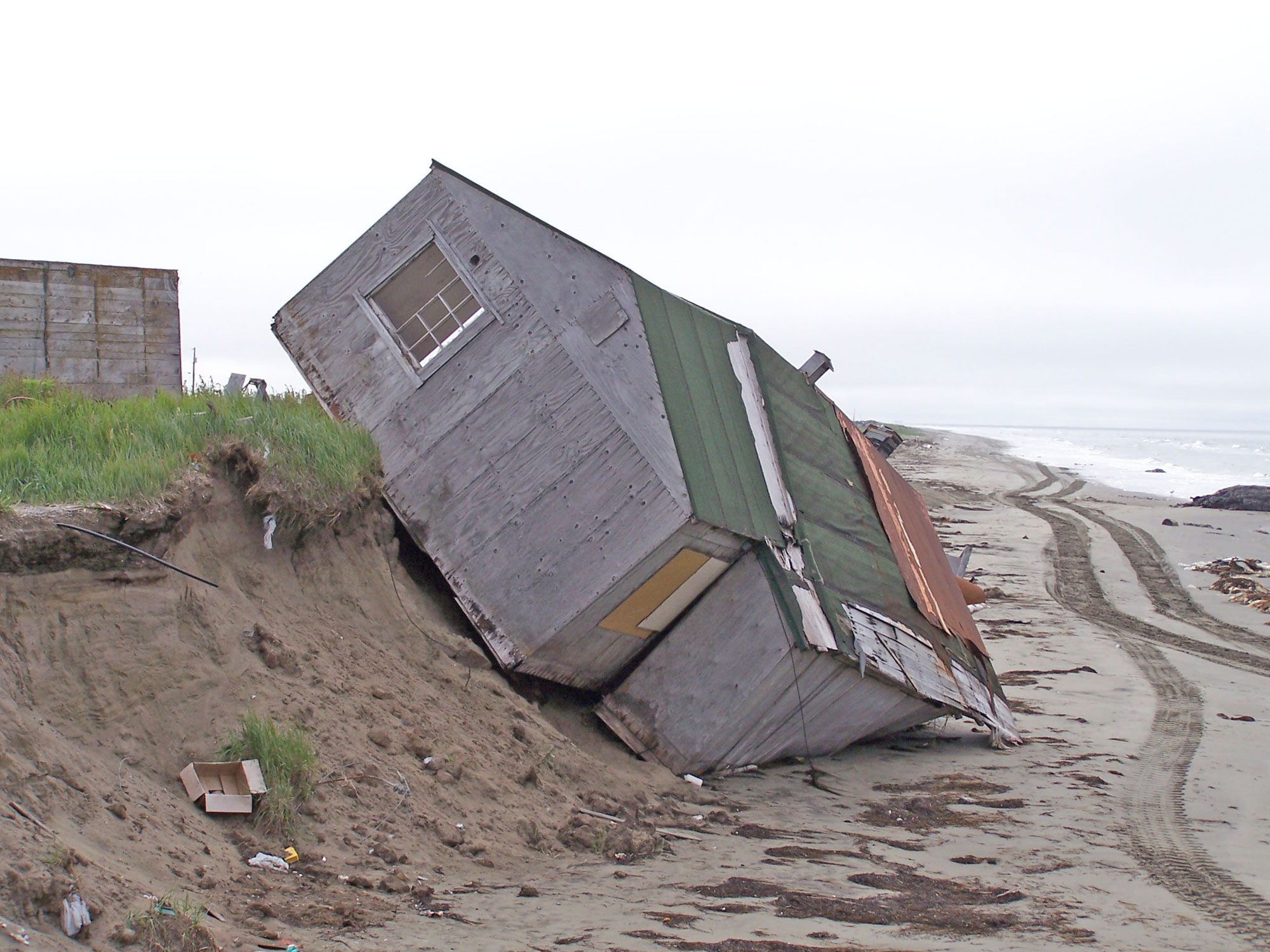
Original caption (National Park Service): "Reduced sea ice cover and thawing permafrost has allowed wave action to erode coastal land forms in Northern Alaska. This home was undermined by storms in November 2006 and photographed in August 2007." Location: Shishmaref, Seward Peninsula, west-central Alaska. Photo by Robert Winfree, National Park Service, AKRO (public domain).
Resources
Resources from the Paleontological Research Institution
Books
Allmon, W. D., T. A. Smrecak, and R. M. Ross. 2010. Climate change—past, present & future: a very short guide. Paleontological Research Institution Special Publication 38, Ithaca, NY, 200 pp.
Websites
Digital Encyclopedia of Earth Science: Why talk about climate change?: https://earthathome.org/de/talk-about-climate/
Digital Encyclopedia of Earth Science: What is climate?: https://earthathome.org/de/what-is-climate/
Digital Encyclopedia of Earth Science: Evidence for and causes of recent climate change: https://earthathome.org/de/recent-climate-change/
Digital Encyclopedia of Earth Science: Climate change mitigation: https://earthathome.org/de/climate-change-mitigation/
Earth@Home: Quick guides & FAQ: Climate and Energy: https://earthathome.org/quick-faqs/#climate
Earth@Home: Here on Earth: Introduction to Climate: https://earthathome.org/hoe/climate/