

Page Snapshot: Introduction to Earth hazards in the northeastern United States.
Contents
Topics covered on this page: Introduction; Earthquakes; Landslides; Land subsidence, karst, and sinkholes; Radon; Floods; Sea level rise and coastal erosion; Weather hazards; Climate change; Resources.
Credits: Some of the text on this page comes from "Earth Hazards of the Northeastern US" by Jane Elizabeth Ansley, The Teacher-Friendly Guide to the Earth Science of the Northeastern US (published in 2000 by the Paleontological Research Institution, reprinted in 2016; currently out of print). The book was adapted for the web by Elizabeth J. Hermsen and Jonathan R. Hendricks in 2023. Changes include formatting and revisions to the text and images. Credits for individual images are given in figure captions.
Updates: Page last updated September 19, 2023.
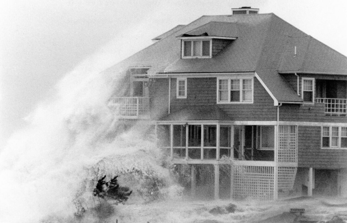
Image above: Original caption: "An Enormous wave crashes the side of a home on High Cliff Rd in the Long Beach section of Gloucester [Massachusetts]. The home was in the final stages of being built. It now is threatened by high waves with total destruction." This photo was taken on October 30, 1991, during the "Perfect Storm" that lashed the coastline of the Northeast. Photo by Jim Daly, the Salem News Historic Photograph Collection, Salem State University Archives and Special Collections, Salem, Massachusetts (flickr, Creative Commons Attribution 2.0 Generic license, image cropped and resized).
Introduction
Natural hazards are events or processes that have significant impacts on human beings and the environment. Extreme weather conditions or geologic activity can cause substantial short-term or long-term changes to our environment. These changes can influence many aspects of the world around us, including crops, homes, infrastructure, and the atmosphere. The 4.6-billion-year-old Earth has experienced many naturally generated hazards, while other events are byproducts of human activities, created during mineral and energy extraction or in construction practices that modify the landscape.
Geology affects where we live, how we live, and how we use the land. In the Northeast, earthquakes, landslides, land subsidence, and radon are important issues tied to the type of rocks found at the surface and underlying the region. Weather events like extreme rainfall, heavy snowfall, and hurricanes also affect the Northeast. These hazards disrupt human lives and infrastructure. Whether directly caused by human activity (such as landslides and land subsidence in some cases) or simply a natural process (such as earthquakes or the production of radon gas), the significance of these hazards is magnified because of the presence of people. Ideally, growing knowledge of environmental issues and an understanding of their foundation in geology will help us to make wiser and more informed decisions about land use and planning.
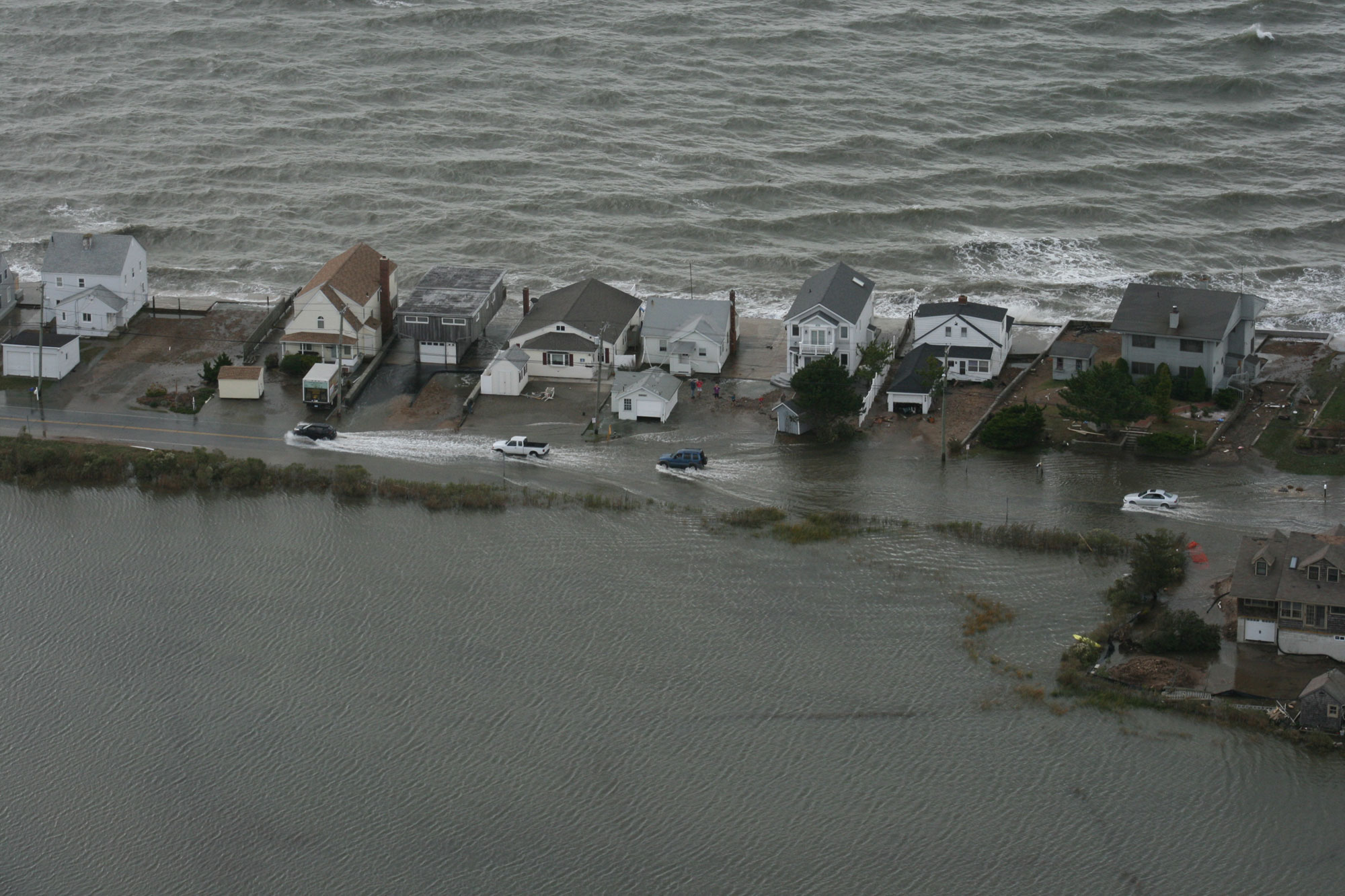
Flooding in Connecticut following Hurricane Sandy, October, 30, 2012. Photo by Connecticut National Guard (Dannel Malloy on flickr, Creative Commons Attribution 2.0 Generic license, image resized).
Earthquakes
Ninety-eight percent of earthquakes occur at tectonic plate boundaries. As the plates collide, pull apart, or move past each other, their grinding and shifting build up stress. When these stresses are released suddenly at the plate boundary or at faults near the boundary, the crust shifts and seismic waves are released, causing an earthquake. During the break up of Pangea and the preceding mountain-building events, there was an active plate boundary at the margin of the east coast of North America. Today, the eastern margin of North America is no longer at an active plate boundary.
Although large quakes are not common events in the Northeast, earthquakes do occur, most likely caused by old faults formed when the eastern margin of North America was an active plate boundary. Stress upon the old faults may force them to shift suddenly, causing an earthquake. Geologists have not had much luck, though, relating earthquake events in the Northeast to known faults. Due to the vague relationship between earthquakes and faults in the Northeast, it is difficult to assess the risk of earthquakes in the region. Using historical records of the Northeast dating back to the 1500s, geologists predict that future earthquakes are most likely to occur in the same general areas as past earthquakes.
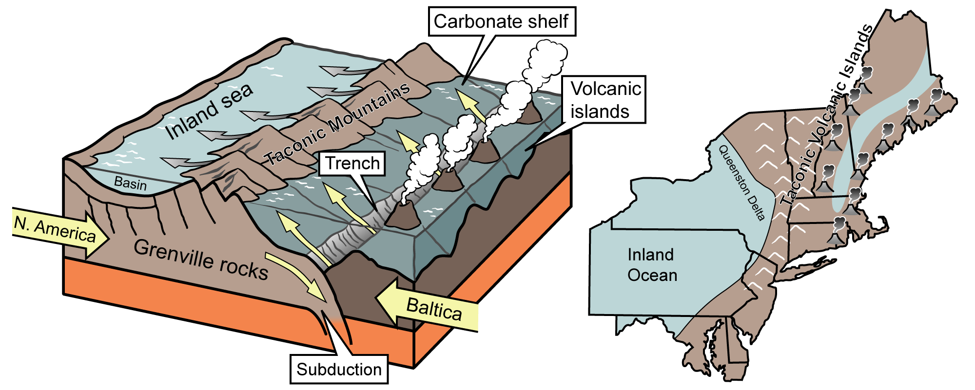
In the Cambrian and Ordovician periods, the Northeastern U.S. was on an active plate boundary. Volcanic islands formed where the plates were forced together as the Iapetus Ocean closed. The compression crumpled the crust to form the Taconic Mountains and a shallow inland sea farther to the west. Earthquakes in the Northeast occur along old faults from this and other intervals of mountain-building in the region. Image modified from original by J. Houghton first published in The Teacher-Friendly Guide to the Geology of the Northeastern U.S. by Jane Ansley (published by the Paleontological Research Institution) (CC BY-NC-SA 4.0 license).
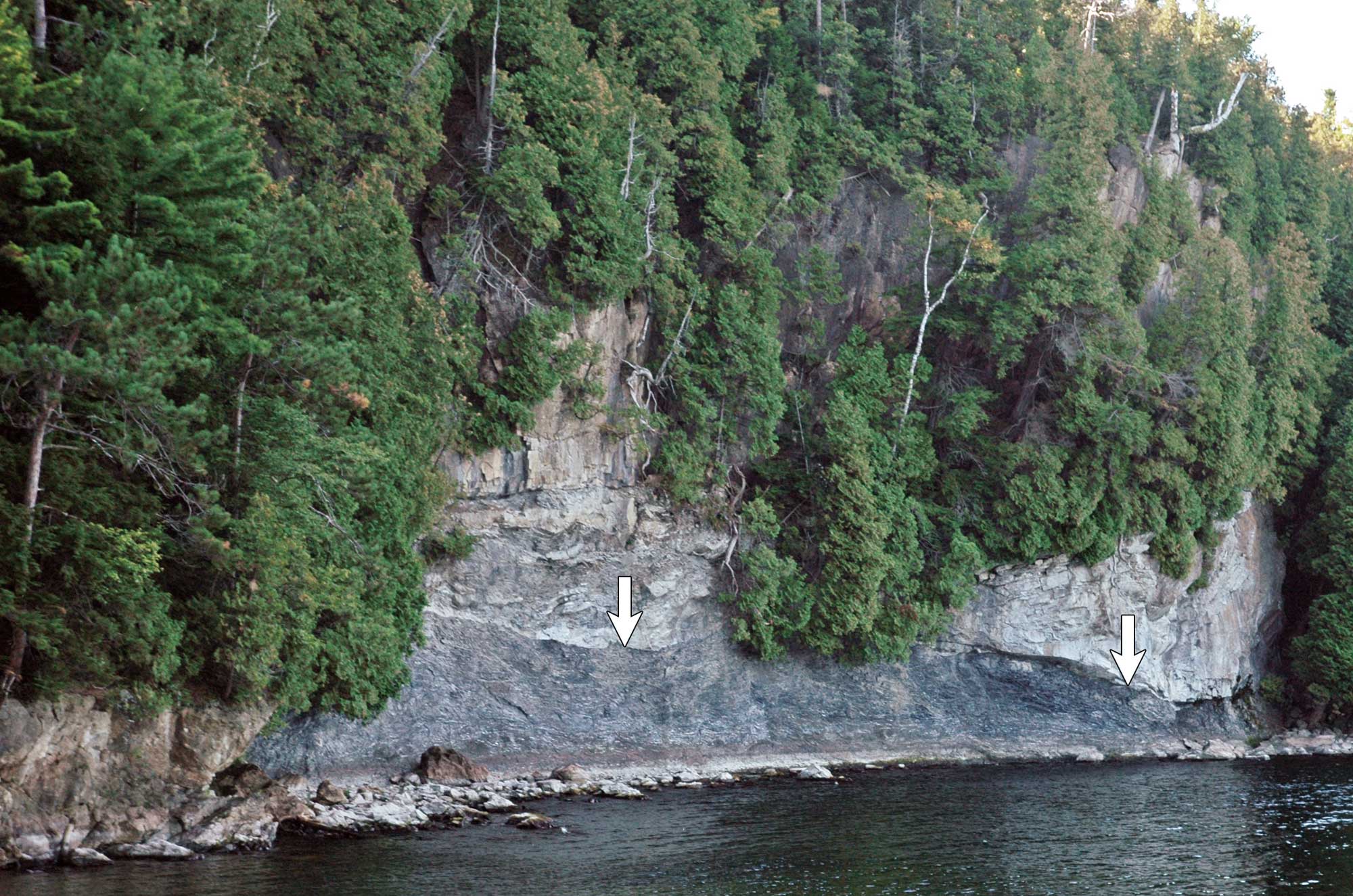
The fault above (the arrow indicates the fault) is the Champlain Thrust Fault in Vermont, a fault dating to the Taconic Orogeny that separates the Cambrian Dunham Dolostone (upper, light gray rocks) from the Ordovician Iberville Formation (lower, dark gray rocks). Photo and information from James St. John (flickr, Creative Commons Attribution 2.0 Generic license, arrow added and image resized).
While the Northeast has a lower risk of earthquakes than some other areas of the U.S., the greater population density of the East Coast means that a large quake could possibly be more damaging than a similar earthquake in the West. Many buildings in the Northeast were not built with earthquakes in mind and could potentially be damaged by strong tremors. Additionally, seismic waves travel further in the eastern U.S. The active plate boundary on the West Coast makes near-surface rocks west of the Rocky Mountains warmer than rocks east of the Rocky Mountains. Heat absorbs seismic waves, and they are unable to travel as far. Cooler rocks, like those of the Northeast, are less of an impediment to seismic waves, allowing them to travel further and potentially cause more damage.
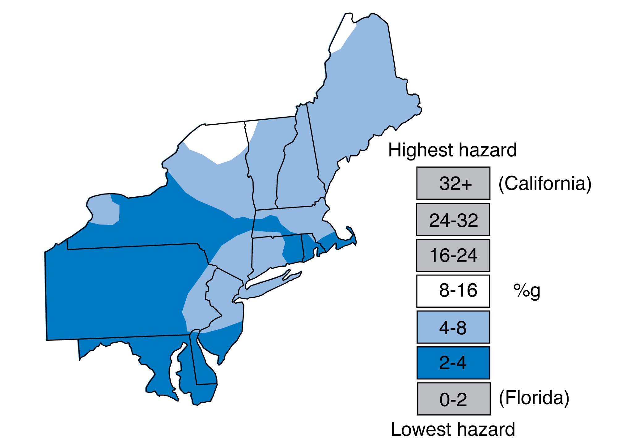
Earthquake risk in the Northeast. Earthquake-induced ground movement is expressed as a percentage of the force of gravity (%g). The map illustrates the amount of ground shaking that is predicted in a given period of time. Illustration from The Teacher-Friendly Guide to the Geology of the Northeastern U.S. (J. E. Ansley, 2000, out of print), modified for Earth@Home.
Most earthquakes in the Northeast are minor, rarely causing any damage. Minor earthquakes occur in every state throughout the Northeast, although relatively few have been located in the Inland Basin region, where the crust has experienced little deformation relative to the rest of the Northeast. Occasionally, large earthquakes occur in the region. One of the largest was on November 18, 1755, off Cape Anne, Massachusetts. The vibrations from the quake were felt over 450,000 square kilometers (173,755 square miles). Very few earthquakes in the Northeast have a magnitude greater than 5 on the Richter Scale; most have a magnitude of less than 2. Nevertheless, earthquakes measuring over 5 on the Richter scale have occurred in Maine, New Hampshire, New Jersey, New York, and Pennsylvania.
Largest earthquakes in each state1
| State | Date | Magnitude | Intensity |
|---|---|---|---|
| Connecticut | 1791 | VII | |
| Delaware | 1871 | VII | |
| Maine | 1904 | 5.1 | VII |
| Maryland | 1990 | 2.5 | V |
| Massachusetts | 1755 | VIII | |
| New Hampshire | 1940 | 5.5 | VII |
| New Jersey | 1783 | 5.3 | VI |
| New York | 1944 | 5.8 | VIII |
| Pennsylvania | 1998 | 5.2 | VI |
| Rhode Island | 1976 | 3.5 | VI |
| Vermont | 1962 | 4.2 | V |
1Data from the USGS.
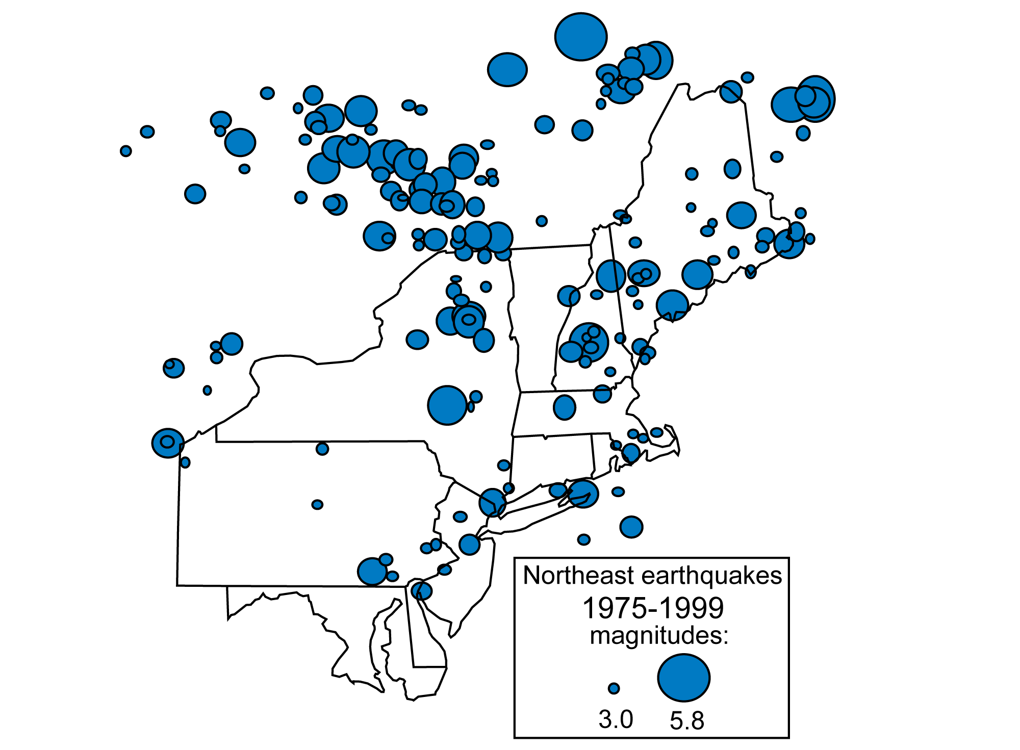
Earthquakes with a magnitude greater than 3.0 in the northeastern U.S. from 1975 to 1999. Illustration from The Teacher-Friendly Guide to the Geology of the Northeastern U.S. (J. E. Ansley, 2000, out of print), modified for Earth@Home.
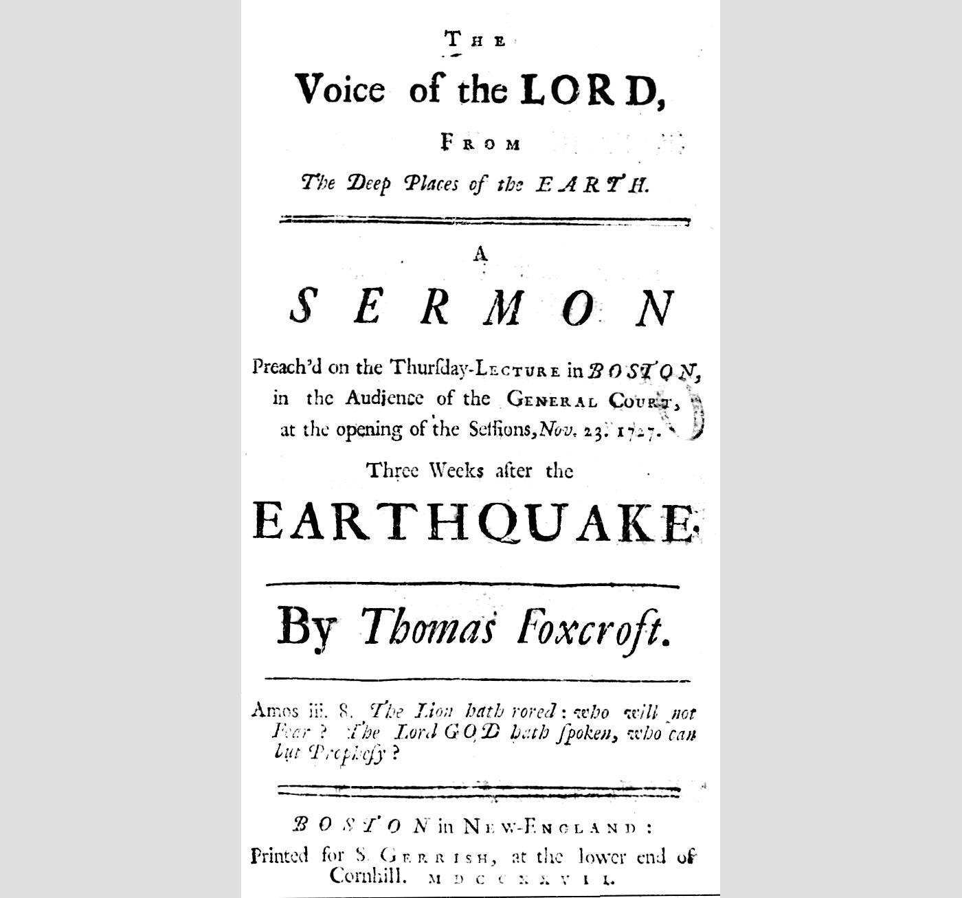
Cover of a printed sermon by the minister Thomas Foxcroft, originally given in Boston, Massachusetts, following an earthquake and aftershocks that occurred during the night of October 29-30, 1727 (Julian calendar) or November 10-11, 1727 (Gregorian calendar). Image by Earth American Imprints, Series 1 (pubic domain).
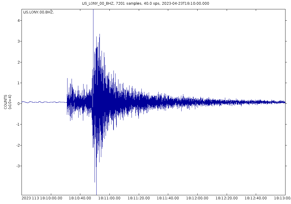
Seismograph showing a 3.6-magnitude earthquake in Adams Center, New York, April 23, 2023. Image by James St. John (flickr, Creative Commons Attribution 2.0 Generic license).
Landslides
Intense rainfall, rapid snowmelt, and steep hillsides are prime conditions for a landslide. Landslides range from watery mud to thick mud carrying rock, boulders, and trees, to toppling rocks off steep slopes. Moving as fast as 60 kilometers/hour (more than 37 miles per hour), landslides can potentially cause millions of dollars of damage to buildings and roads as well as human fatalities.
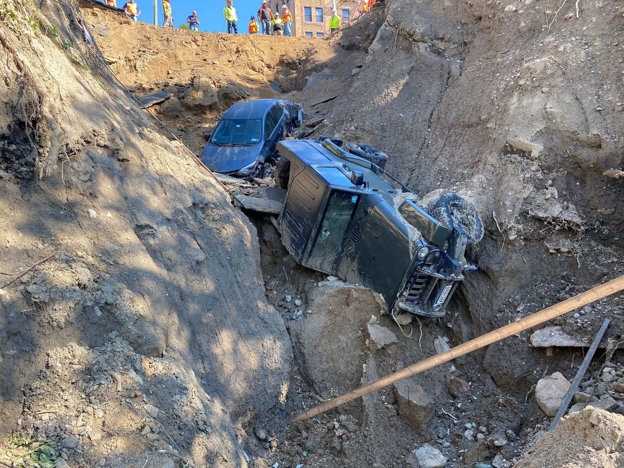
A landslide in Yonkers, New York, that was triggered by heavy flooding caused by Hurricane Ida, 2021. Photo by MTA Metro-North Railroad (flickr, Creative Commons Attribution 2.0 Generic license, image resized).
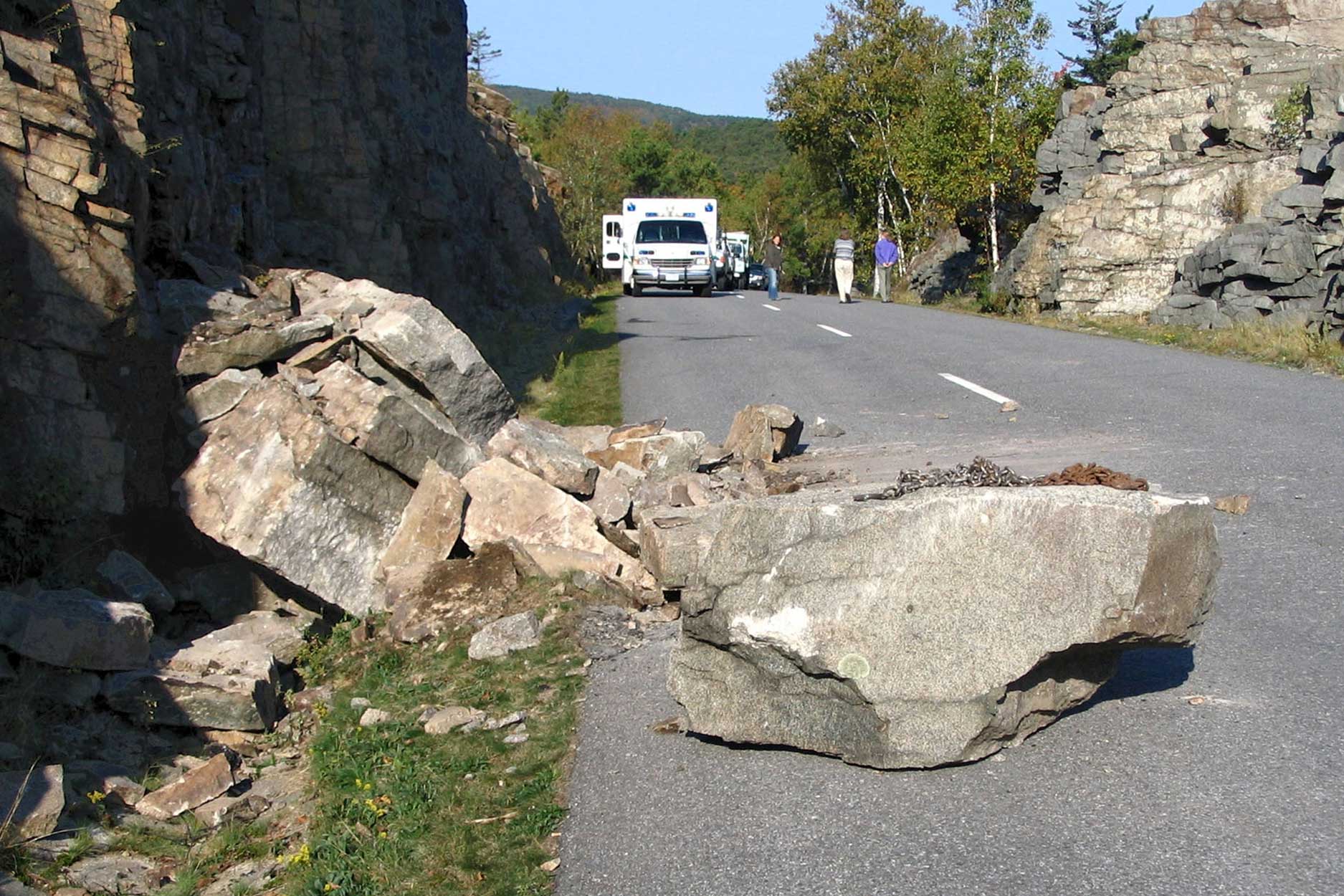
A rockslide on a road in Acadia National Park, Maine. Photo by U.S. National Park Service (public domain).
In the Northeast, landslides are common in the Appalachian Mountains, New England, and the Appalachian Plateau due to steep slopes, a fairly rugged landscape, and clay-rich soils. Though the Appalachian Plateau is called a plateau, it is deeply dissected by river valleys that have formed steep slopes along which landslides are common.
In the glaciated areas of the Appalachian Plateau, including northern Pennsylvania and most of New York, clays were deposited at the bottom of glacial lakes occupying glacially carved valleys. Though many of the lakes no longer exist, the clay deposits still remain and are a source of landslides in the region. Clay and clay-rich soils that become saturated with water have drastically reduced friction, allowing other rock layers or sediment to slide rapidly upon them.
Other causes of landslides, especially in the Appalachian Plateau region, are the result of the activities of humans. Underground mining, common in the bituminous coal fields of western Pennsylvania and Maryland, reduces the stability of overlying rock and often results in landslides. When older mines are filled, the settling rocks and sediments can cause landslides. Poorly engineered fills on slopes can also trigger landslides.
Recognition of landslide-prone areas is important for land use planning and zoning decisions. Damage from landslides can be prevented by not building in areas that commonly experience landslides or show evidence of past landslides.
Land subsidence, karst, and sinkholes
Land subsidence is an issue in the Northeast, though more often in the Appalachian/Piedmont and Inland Basin regions. Mines and carbonate rocks are the primary causes of land subsidence. The large amount of underground excavation during mining, especially the coals of western Pennsylvania and Maryland, has left large areas beneath the surface empty or filled with loose sediment. The empty spaces and sediment fills are sometimes unable to wholly support the weight of overlying rocks. As a result, the overlying rocks and soil sag or sink downward to create a depression in the land surface. In extreme cases, the overlying rocks collapse completely or the subsidence causes a landslide.
Areas of the Northeast underlain by carbonate rocks, in particular the Valley and Ridge region of the Appalachian/Piedmont, are susceptible to land subsidence. Rainwater, which is naturally slightly acidic and becomes more acidic after passing through acidic soils, is capable of breaking down carbonate rocks. Within a carbonate rock layer might be caverns, widened fractures, and spaces that make the layer an unstable support for overlying rocks. Similar to mine collapses, the overlying rock in a carbonate area has a high potential for collapsing and creating sinkholes.
Land subsidence can cause major problems, particularly in urban areas where sewer systems, water lines, and gas pipes can be damaged due to the sagging ground surface. In places where the surface collapses, buildings and roads can be badly damaged. Sinkholes also provide a fast drainage from the surface to groundwater, increasing the chances of polluting groundwater supplies.
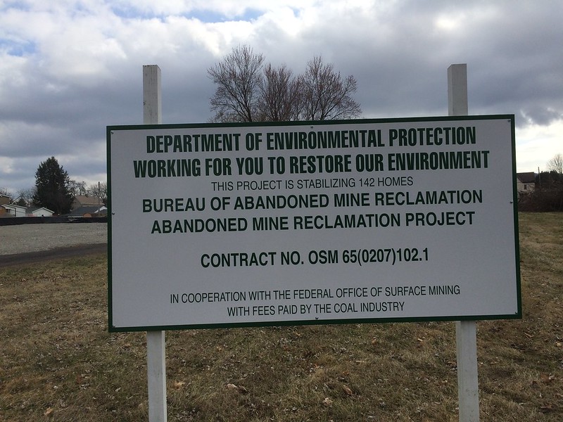
A sign in Bradenville, Pennsylvania, providing notice about a project to shore up land subsiding due to the presence of old underground mines in the area. Photo by BuzzWeiser196 (Wikimedia Commons, Creative Commons Attribution-ShareAlike 4.0 International license).
Radon
Radon is a chemical element: an odorless, colorless, radioactive gas that commonly forms from the breakdown of the element uranium. Radon first came to wide public attention as an environmental issue in the mid-1980s when high concentrations of the gas were found in houses overlying the Precambrian rocks of the Reading Prong in southeastern Pennsylvania.
The igneous and metamorphic rocks of the Appalachian Mountains and Adirondacks are uranium-rich and sliced by numerous faults, resulting in an area with the potential for high levels of indoor radon. The mineral glauconite, found in parts of the Coastal Plain sediments, is also uranium-rich. For the most part, however, the Coastal Plain has one of the lowest levels of radon risk in the country.
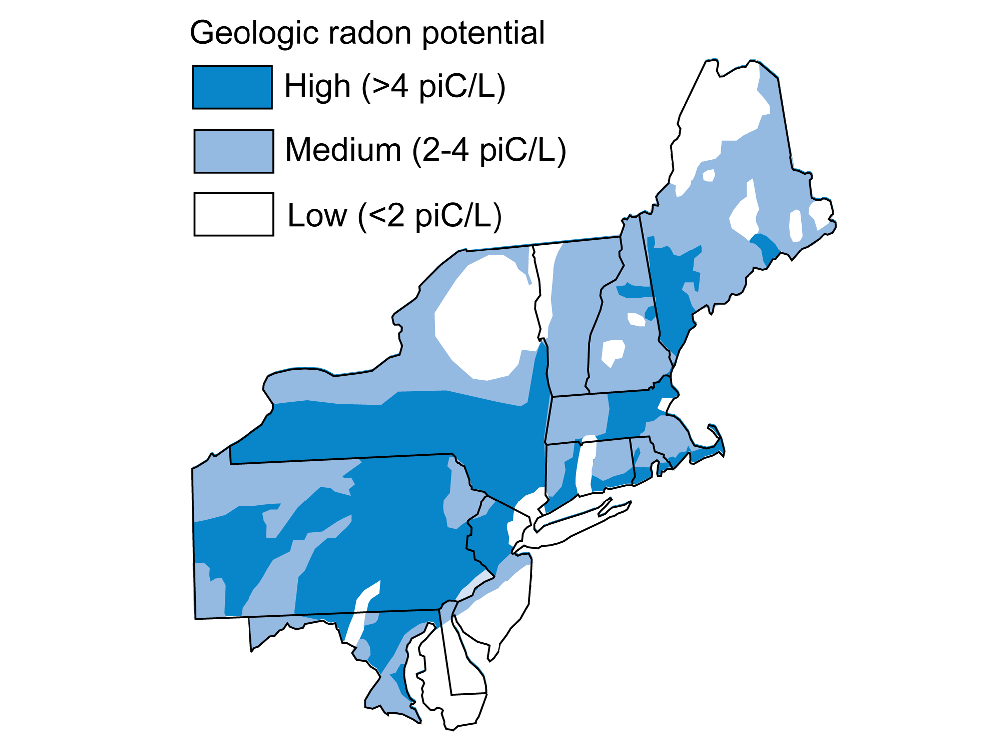
Radon potential in the Northeast. Illustration from The Teacher-Friendly Guide to the Geology of the Northeastern U.S. (J. E. Ansley, 2000, out of print), modified for Earth@Home.
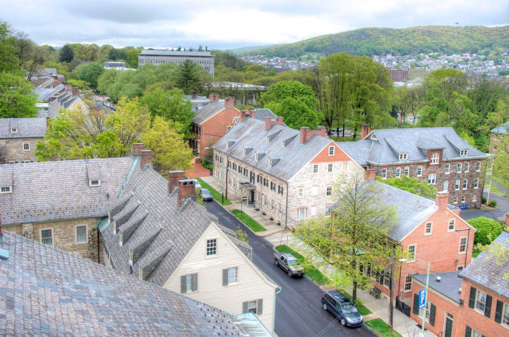
A historic area in Bethlehem, Pennsylvania. Bethlehem is in the Lehigh Valley, which is located in the Reading Prong, an area underlain by radon-emitting bedrock. Photo by Bestbudbrian (Wikimedia Commons, Creative Commons Attribution-ShareAlike 4.0 International license, image resized).
Floods
In the Northeast, major flooding can be caused by high rainfall, which can swell rivers, and by major coastal storms, especially tropical storms and hurricanes. Historically, the worst flood in terms of loss of human life in the northeastern U.S. was the Johnstown flood of May 31, 1899. This flood occurred when heavy rains caused a dam on the South Fork of the Little Conemaugh River to fail, sending a torrent of an estimated 3.6 billion gallons of water downstream, which swept through the community of Johnstown, Pennsylvania, as well as other towns in its path. The final official death toll was more than 2200 people, although the real number of dead is thought to have been more than 3000. Two other major floods caused deaths in Johnstown following the 1899 flood. The most recent was in 1977 and killed at least 85 people.
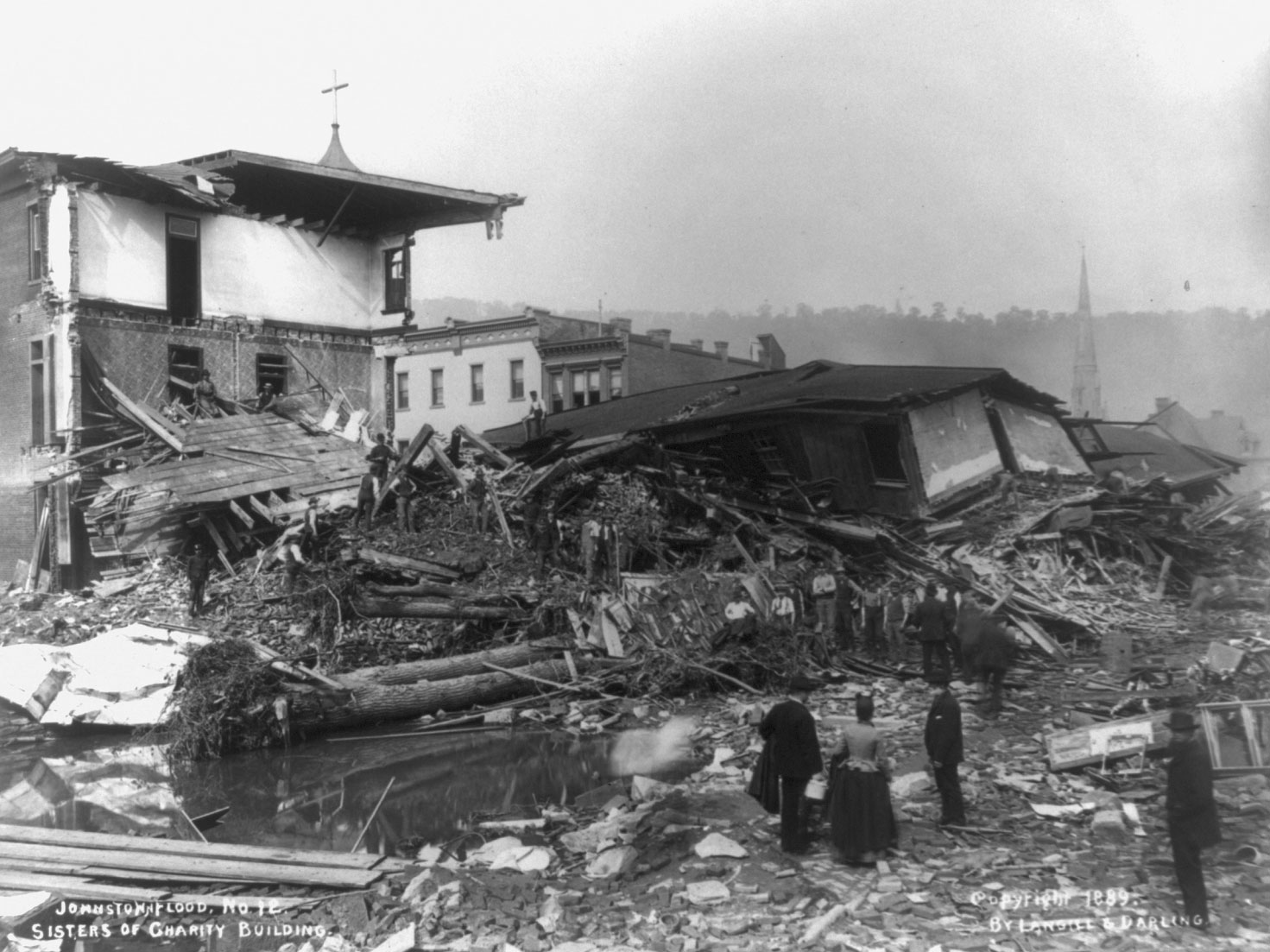
The remains of the Sisters of Charity building, Johnstown, Pennsylvania, following the 1899 Johnstown Flood. Photo by Langill & Darling (Library of Congress Prints & Photographs Online Catalog, reproduction number LC-USZ62-60959, no known restrictions on publication).
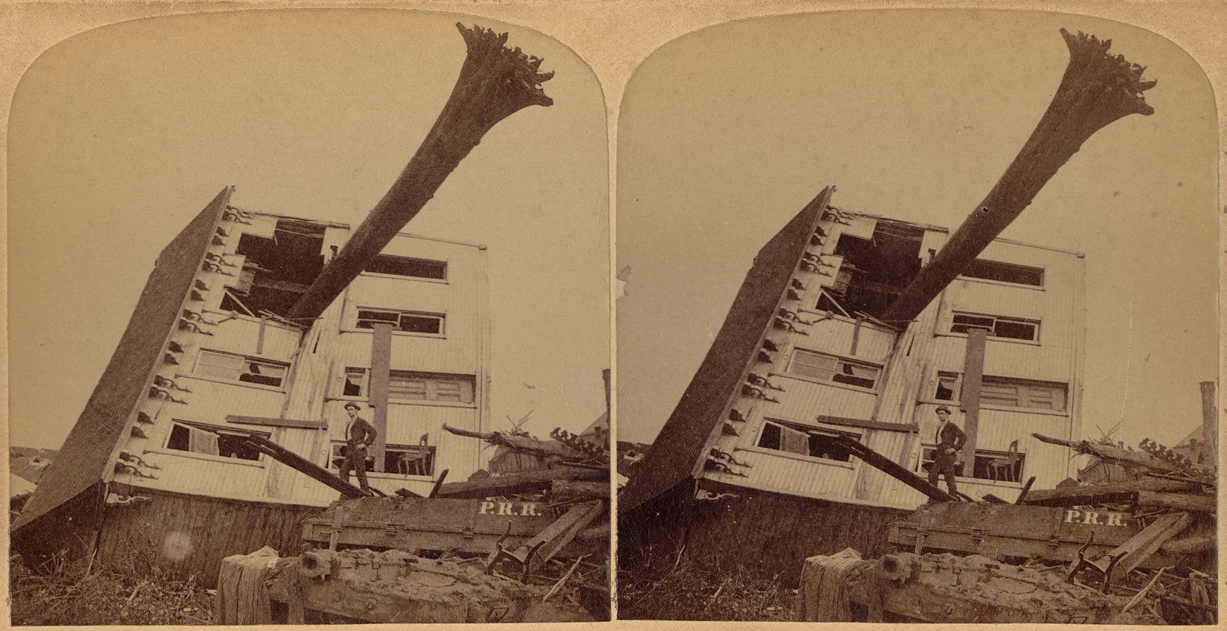
A stereopair of a house damaged in the Johnstown Flood, 1899. Photo by George Barker, published by Strohmeyer & Wyman, Publishers (Boston Public Library on flickr, Creative Commons Attribution 2.0 Generic license, image cropped).
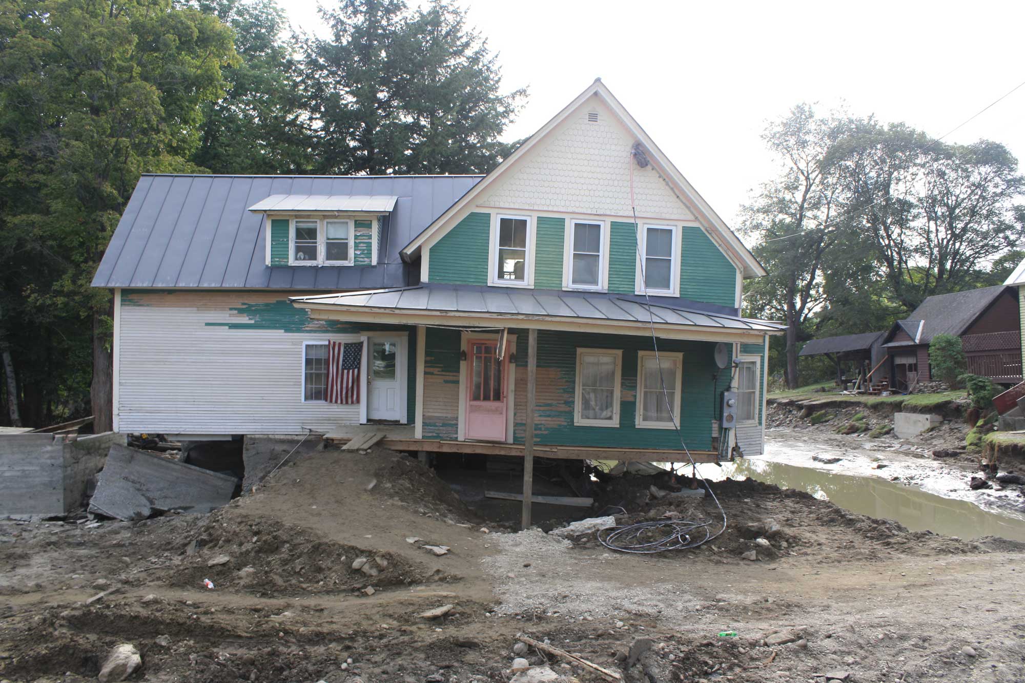
Major flooding has also occurred recently in the Northeast. For example, in 2011, Hurricane Irene came ashore near Long Island, New York, and rainfall from the storm caused widespread and severe flooding in the New York and New England regions, even far inland. Vermont and eastern New York were again affected by flooding in 2023, when the right combination of conditions caused an unusually heavy July rainstorm. Vermont reportedly received the equivalent two months of rain in less than two days, wheres about 5 to more than 8 inches (about 13 to 30 centimeters) of rain fell in parts of New York. Heavy snowfall followed quickly by above-freezing temperatures can cause rapid snow melt and flooding in this region as well.
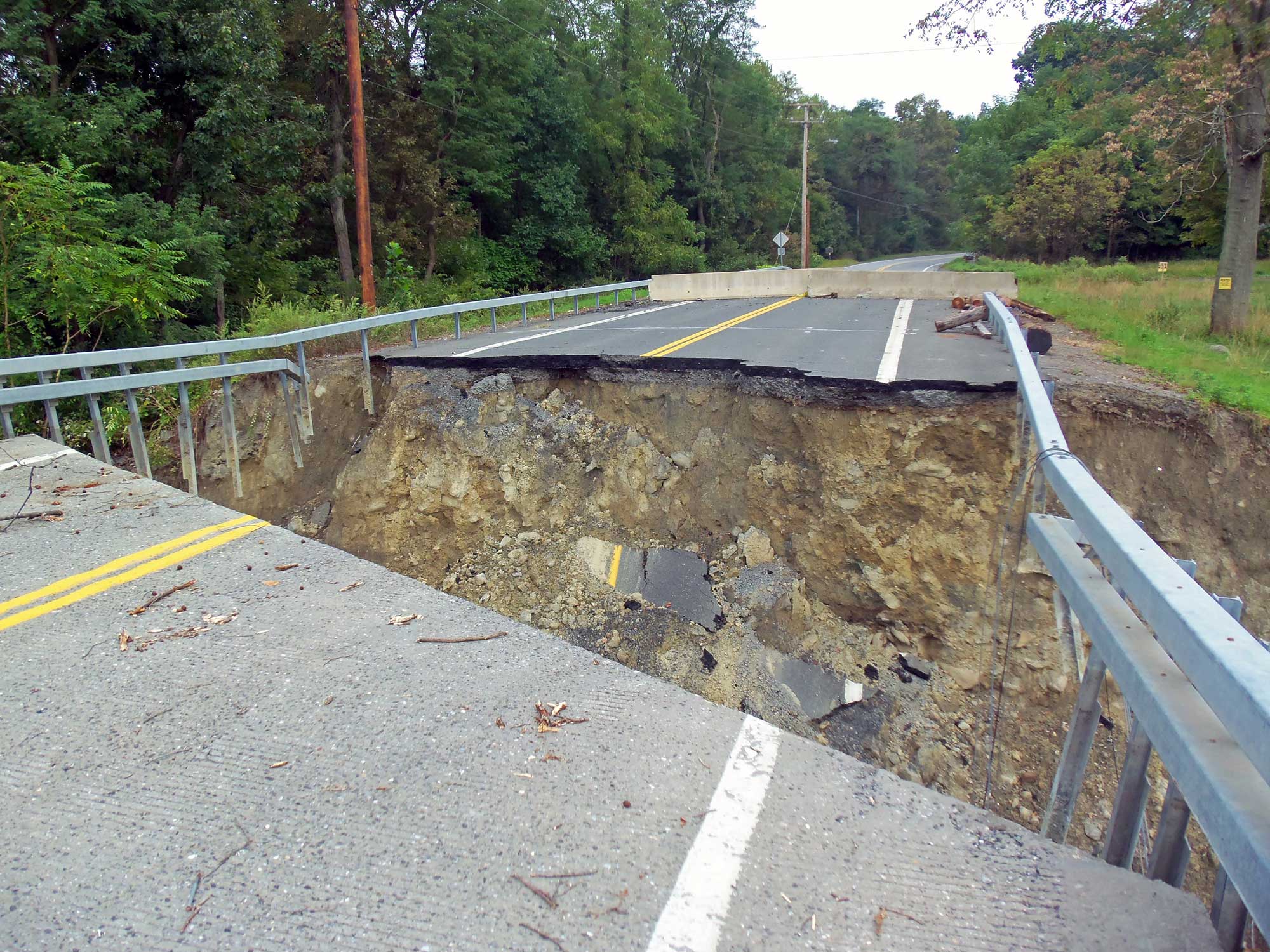
A bridge across Moodna Creek, Forge Hill Road, New Windsor, New York, washed out following flooding from Hurricane Irene, 2011. Photo by David Case (Wikimedia Commons, Creative Commons Attribution-ShareAlike 3.0 Unported license, image resized).
A house and road in Bethel, Vermont, damaged by flooding from Hurricane Irene, 2011. Photo by Ann Froschauer/USFWS (flickr, public domain).
The Northeast's Coastal Plain is topographically low and flat and is therefore more prone to flooding—from a variety of sources—than many other areas of higher elevation farther inland. Flooding can occur because of both rainfall and storm surge. Strong offshore winds can drive water and even boats across beaches and far upstream in rivers, especially during times of high tide. The inland surge of ocean water is often of a disastrous proportion, especially when it is associated with hurricanes.
While floods are always considered a hazard to life and property, they present a compound threat when they trigger mudslides. While there is no way to completely avoid the destructive impacts of flooding, good community planning and informed decision-making can greatly reduce the safety concerns and economic impacts of these events. Flood control is part of the mission statements of many government agencies, including the National Resource Conservation Service (NRCS), US Corps of Engineers (USCE), and US Geological Survey (USGS).

Members of the New Jersey National Guard providing assistance following Hurricane Sandy, Hoboken, New Jersey, 2012. Photo by Spc. Joseph Davis, U.S. Army Photo (The National Guard on flickr, U.S. government work).
Sea level rise and coastal erosion
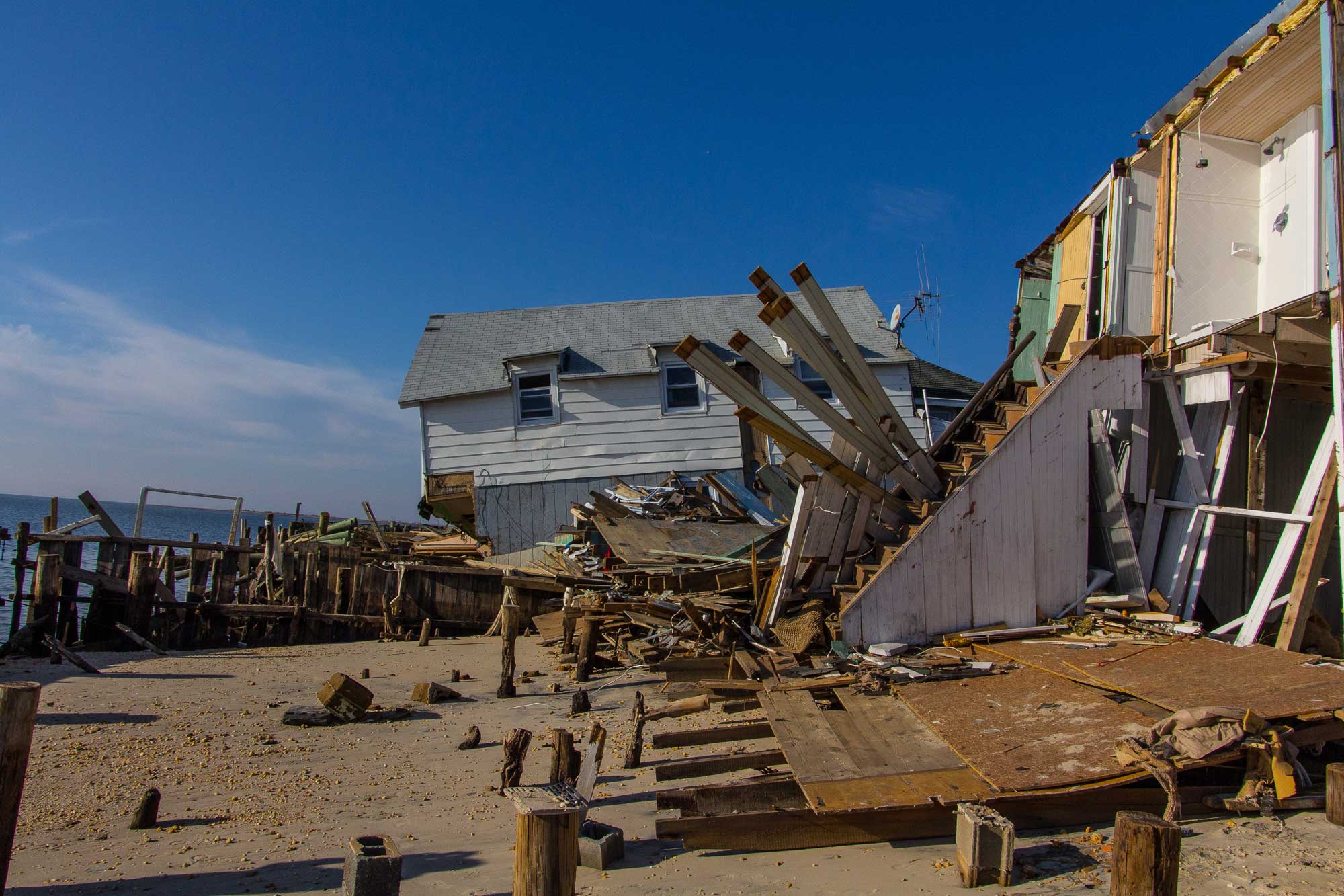
Like other coastal areas in the U.S., coastal areas in the Northeast are threatened by coastal erosion and sea level rise. Some of the major islands and shoreline features in the Northeast, like Long Island, Martha's Vineyard, Block Island, and Cape Cod, are formed by glacial moraines rather than hard bedrock. Shorelines that are made up of gravel or sand rather than rock are subject to relatively rapid erosion by wave action and longshore currents. Many densely populated areas of the Northeast, including New York City and Boston, are along the coast and are threatened by rising sea levels caused by climate change.
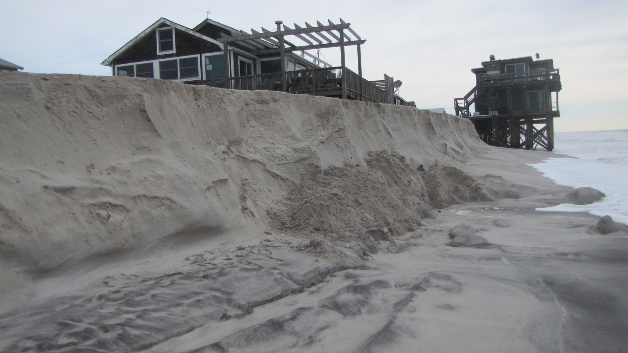
Original caption: "Though often less intense than hurricanes, extratropical storms (e.g., nor’easters) occur more frequently and their impacts can be striking. Here, several years after Hurricane Sandy [which occurred in 2012], winter nor’easters eroded sediments from an artificial dune at Fire Island, NY and moved them onto the beach and shoreface. Such erosion created a steep vertical face, or scarp." Photo by Kyle Kelso (USGS, Public Domain).
Weather hazards
The Northeast is impacted by different types of severe weather, including winter storms, thunderstorms, and hurricanes. Compared to the adjoining Midwest and Southeastern regions, the Northeast is not particularly prone to tornadoes. It also experiences fewer hurricanes than the Southeast.
Hurricanes
In an average year, about a dozen hurricanes travel through the western Atlantic and sometimes the Gulf of Mexico. Of these, roughly two a year strike the Atlantic coast. The peak month is September, followed by August and October. More rarely, hurricanes may hit the coast in June, July, or November.
Strong hurricanes make landfall much more often in the Southeast than in the Northeast. However, when hurricanes do come ashore in the Northeast, they can have devastating impacts in densely populated, low-lying coastal areas, where they cause storm surges and are accompanied by high winds. Hurricanes can also have impacts inland by bringing heavy rains.
Hurricane Sandy or Superstorm Sandy (technically, a post-tropical cyclone when it made landfall in the Northeast) was one of the most devastating storms to impact the Northeast. This hurricane formed in the Caribbean in late October 2012, passing over Jamaica, Cuba, and the Bahamas, before heading north up the Atlantic coast, coming ashore on October 29, 2012, near Atlantic City, New Jersey. It arrived at high tide; in some areas, it created a storm surge of more than 9 feet (2.7 meters) and dropped more than 1 foot (30.5 centimeters) of rain. Due to the combined storm surge and rain, widespread flooding occurred, including in New York City. As of 2023, NOAA considered Sandy to be the fifth costliest tropical storm to impact the United States in inflation-adjusted dollars.
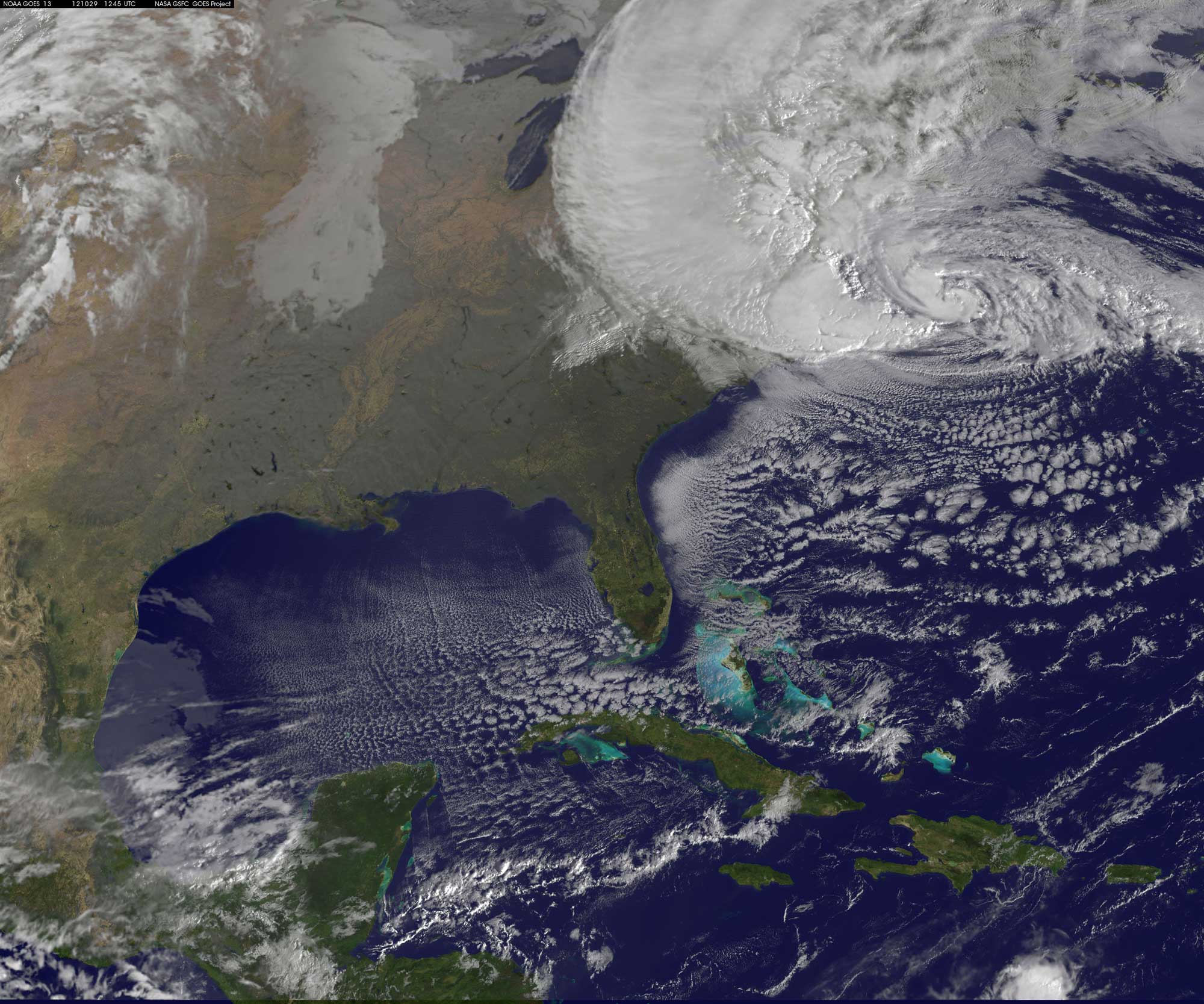
A satellite image of Hurricane Sandy on October 29, 2012 at 9:10 AM eastern daylight time. Photo by NASA GOES Project, NASA/Rob Gutro (NASA Goddard Space Flight Center on flickr, Creative Commons Attribution 2.0 Generic license, image resized).
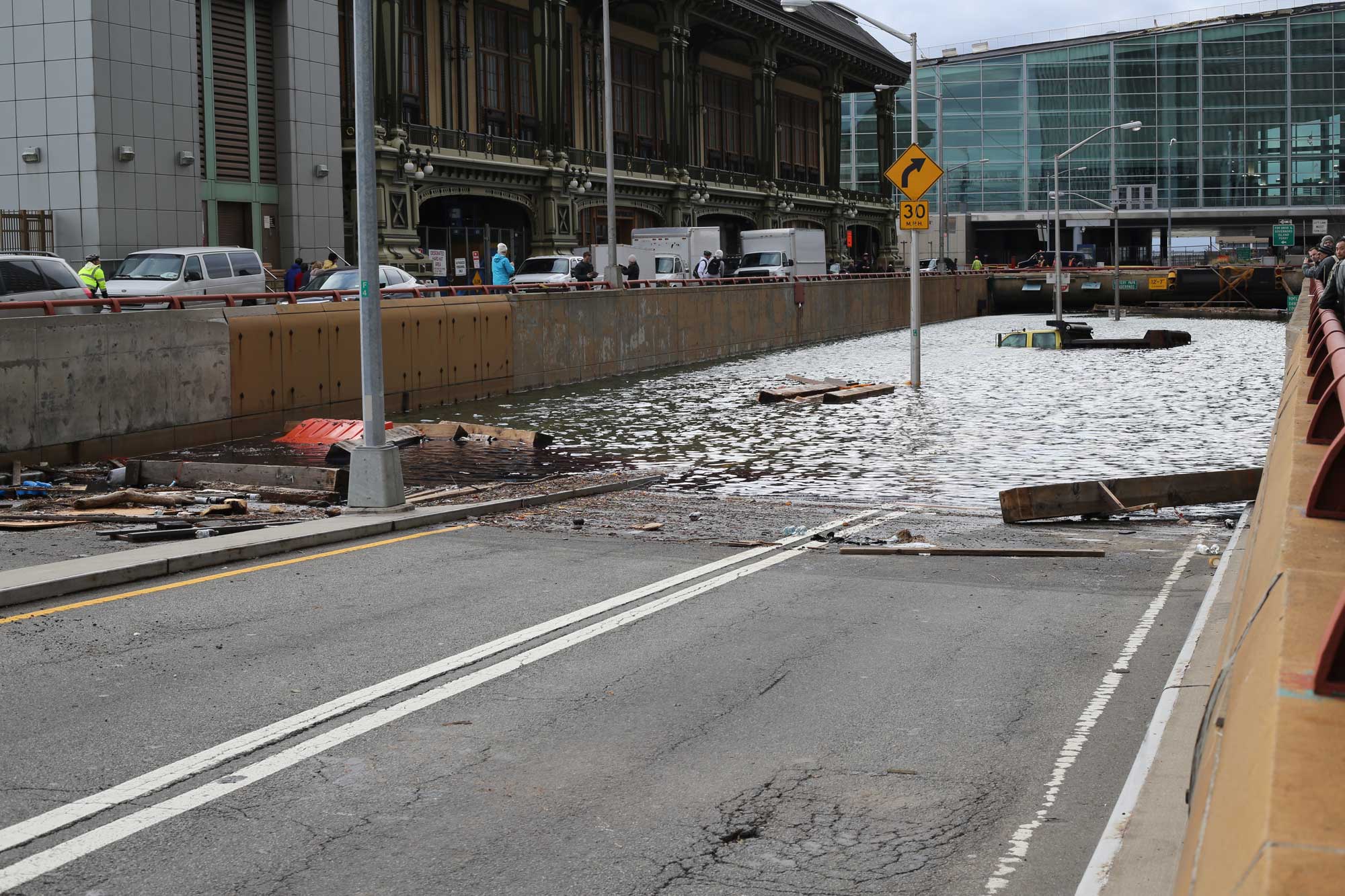
Flooding in the Battery Park Tunnel, Manhattan, New York City, caused by Hurricane Sandy, November 1, 2012. Photo by Timothy Krause (flickr, Creative Commons Attribution 2.0 Generic license, image resized).
Destruction of homes near the shore, Gandy Beach, New Jersey, following Hurricane Sandy, November 23, 2012. Photo by Steve Zumwalt FEMA (National Archives Identifier 24472211, unrestricted use).
Other extreme storms
Extreme precipitation events sometimes occur in the Northeast. These events may be due to hurricanes or tropical storms or unusually heavy rainfall not associated with a hurricane or tropical storm system. The Northeast can also experience experience extremely heavy snowfalls, particularly south and east of Lake Erie and Lake Ontario, where lake effect snow occurs. Occasional Nor'easters, large, powerful winter storms, also affect the Northeast.
The Perfect Storm
One famous and rather unusual Northeastern storm was the "Halloween Storm" of October 28 to November 1, 1991, a coastal storm that later developed into a hurricane. This storm is probably most famous today as the "Perfect Storm" that sunk the fishing boat Andrea Gail on October 28, an event later recounted in a popular book (published in 1997) and a movie (released in 2000). The Halloween Storm was not considered to be a hurricane when it caused massive damage along the New England coastline on October 30 to 31. It only technically became a hurricane on November 1, after it had left the coast and moved back out to sea. Since this hurricane was never named, it is sometimes called the "Unnamed Hurricane."
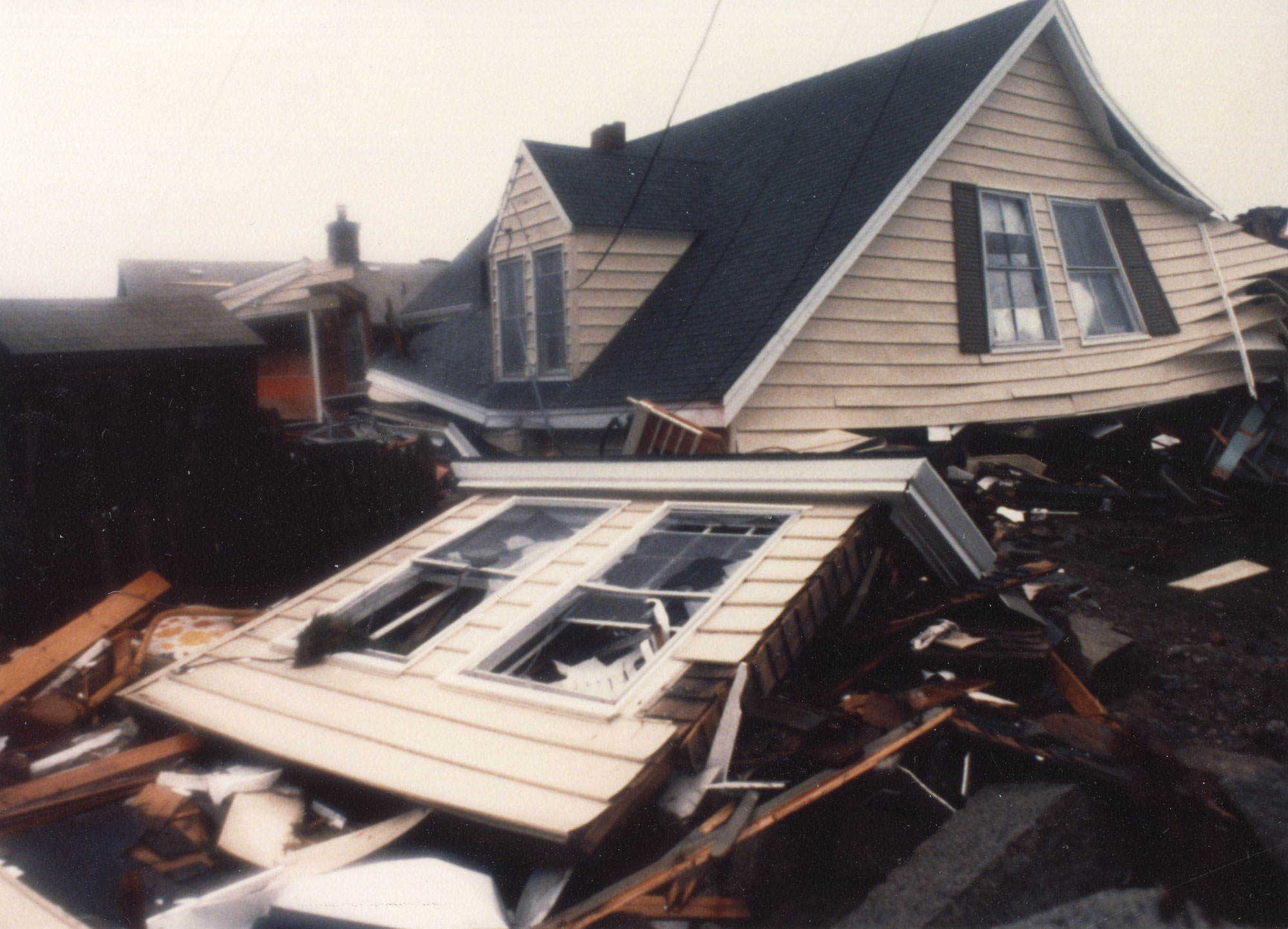
Damage to a home in Massachusetts following the "Halloween Storm" or the "Perfect Storm," October 31, 1991. Photo by Kirk Williamson, The Salem News Historic Photograph Collection, Salem State Archives and Special Collections, Salem, Massachusetts (flickr, Creative Commons Attribution 2.0 Generic license, image cropped and resized).
Snowstorms
While the Northeast generally has good infrastructure to handle heavy snowfalls where they routinely occur, sometimes extreme snowstorms can overwhelm these measures. During the Blizzard of 1993 in March 1993, heavy snow blanketed parts of the Northeast, closing major highways in Massachusetts and New York. The winter of 2014 to 2015 in Boston, Massachusetts, was famous for its record-breaking snowfall, with a total of up to 110.6 inches (2.8 meters) falling from November to March, but most in January and February. So much snow accumulated and temperatures were so cold that snow removal became difficult; some large snow piles did not melt until well into the summer, the last one finally fully disappearing in July.
An unusual combination of events occurred in Buffalo, New York, in December 2022, creating a deadly snowstorm. Buffalo routinely receives lake effect snow from Lake Erie and is one of the snowiest cities in the United States. From December 23 to 27, 2022, Buffalo experienced a lake effect snow event that dumped up to 51.9 inches (131.8 centimeters) of snow in places, accompanied by winds that reached 70 miles per hour (112.7 kilometers per hour) and extremely cold temperatures. In the end, the storm knocked out power to more than 30,000 houses. Forty-seven people died directly or indirectly as a result of the storm.
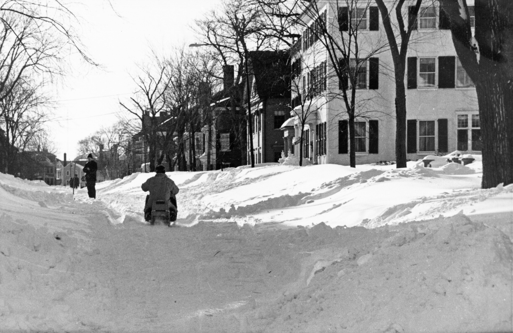
A person riding a snowmobile down Chestnut Street, Salem, Massachusetts, following the Blizzard of 1993. Photo by Ray Wallman The Salem News Historic Photograph Collection, Salem State Archives and Special Collections, Salem, Massachusetts (flickr, Creative Commons Attribution 2.0 Generic license, image cropped and resized).
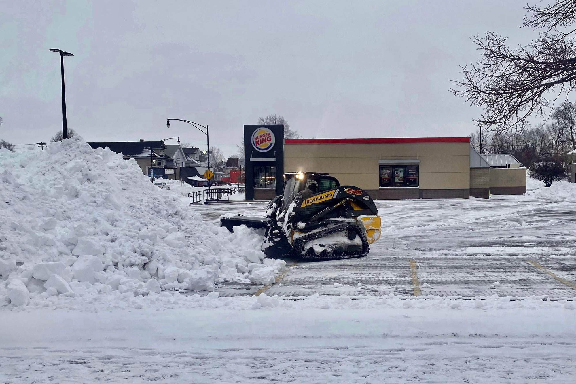
A small bulldozer clearing the parking lot of a Burger King in Buffalo, New York, on December 27, 2022, following a major and unusually deadly snowstorm. Photo by Andre Carrotflower (Wikimedia Commons, Creative Commons Attribution-ShareAlike 4.0 International license, image resized).
Extreme temperatures
Like other parts of the country, the Northeast is subject to heat waves. All of the northeastern states have record high temperatures that exceed 100°F (37.8°C). Hot temperatures pose a special problem when they occur during the school year in the Northeast because many school buildings are not equipped with air conditioning.
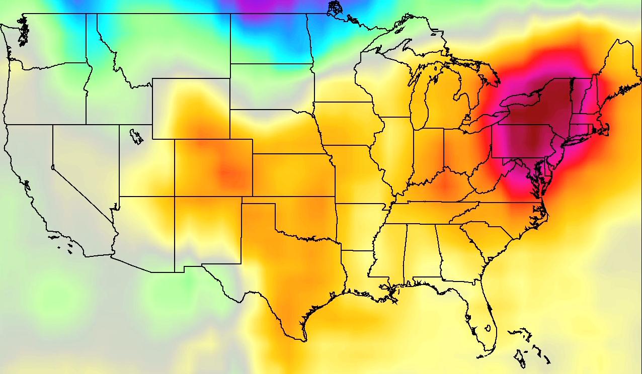
A map of the United States from July 2011 shaded to show temperature, indicating that the northeastern U.S. was experiencing a heat wave. Map by NASA/JPL AIRS Project (flickr, Creative Commons Attribution 2.0 Generic license).
The region also experiences extremes of cold. One type of extreme cold weather event is the polar vortex. As the name implies, a polar vortex is a regularly occurring area of low pressure that circulates in the highest levels of the upper atmosphere. Typically, the polar vortex hovers above Canada. However, a pocket of the counter-clockwise rotating low-pressure center can break off and shift southward at a lower altitude, covering the Northeast with frigid air. The jet stream then shifts to a more southward flow than usual, chilling the Northeast, the Midwest, and even the southern states. A polar vortex can lock the jet stream in this new pattern for several days to more than a week. Extreme low temperatures can endanger livestock, and precautions should be taken regarding travel on roadways.
The coldest temperatures in the Northeast ever recorded were in New York, at -52°F (-46.7°C), with temperatures of -50°F (-45.6°C) having been recorded in New Hampshire and Vermont.
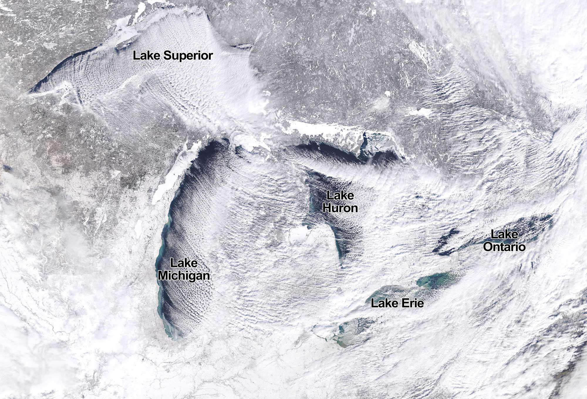
Satellite image showing the Great Lakes region of the United States and Canada during a polar vortex, January 27, 2019. The streaks of snow coming off the Great Lakes are "cloud streets" indicative of lake effect snow. Source: NASA Earth Observatory image by Josh Stevens (used following NASA's image use policy).
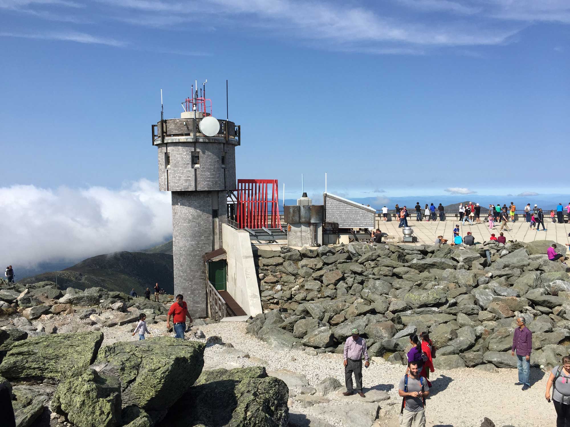
The observation tower at the Mt. Washington Observatory, Mt. Washington, New Hampshire. Mount Washington is the highest peak in the Northeast at 6288 feet (1917 meters) and experiences some of the most extreme cold in the region. It reached its coldest temperature, -50°F (-45.6°C), in 1885. As recently as 2023, a temperature of -47°F (-46.7°C) was recorded on the peak. Photo by Famartin (Wikimedia Commons, Creative Commons Attribution-ShareAlike 4.0 International license, image resized).
Climate change
The rapid release of carbon dioxide into the atmosphere from human activity is currently causing climate to change globally. The seemingly slight increase in the average annual temperatures in the Northeast since 1970 have been accompanied by more frequent heat waves, more rain, less snow, and shorter, warmer winters. One of the major changes that is now affecting the Northeast and will continue to affect the region in the future is sea level rise.
A major concern regarding hazards made worse by climate change in the Northeast is whether or not there has been or will be an increase in the number or severity of storms, such as hurricanes. According to NASA, the present data are inconclusive in terms of whether hurricanes are already more severe, but there is a high chance that global warming will cause more intense hurricanes in the 21st century. Since climate is a measure of weather averaged over decades, it might take many years to determine that a change in storm frequency or intensity has occurred. Scientists are certain that the conditions necessary to form such storms are becoming more favorable due to the warming climate.
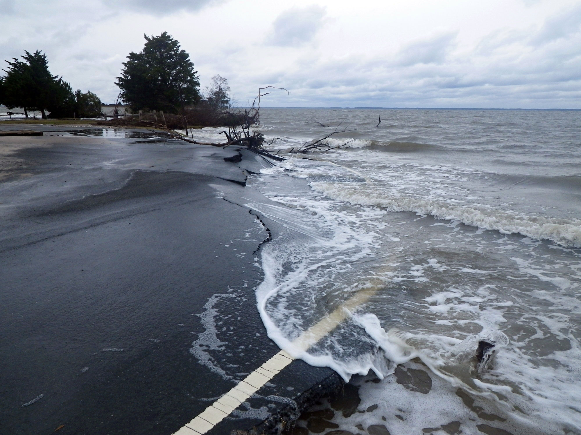
Damage from storm surge, Bayside Picnic Area, Assateague Island National Seashore, Maryland, following Hurricane Sandy, October 2012. Photo by National Park Service (flickr, public domain).