

Spotlight: Overview of the rocks of the Colorado Plateau region of the southwestern United States, including Colorado, New Mexico, Arizona, and Utah.
Topics covered on this page: Overview; Precambrian; Great Unconformity; Paleozoic; Mesozoic; Cenozoic; Resources.
Credits: Most of the text of this page is derived from "Rocks of the Southwestern US" by Lisa R. Fisher and Richard A. Kissel, chapter 2 in The Teacher-Friendly Guide to the Earth Science of the Southwestern US (published in 2016 by The Paleontological Research Institution. The book was adapted for Earth@Home web by Elizabeth J. Hermsen and Jonathan R. Hendricks in 2022. Changes include formatting and revisions to the text and images. Credits for individual images are given in figure captions.
Updates: Page last updated March 26, 2022.
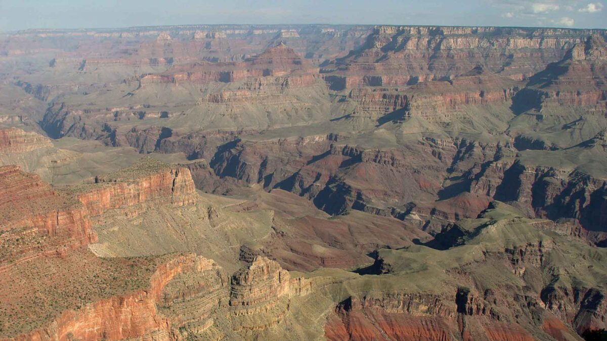
Image above: The Grand Canyon, Arizona. Photograph by Jonathan R. Hendricks.
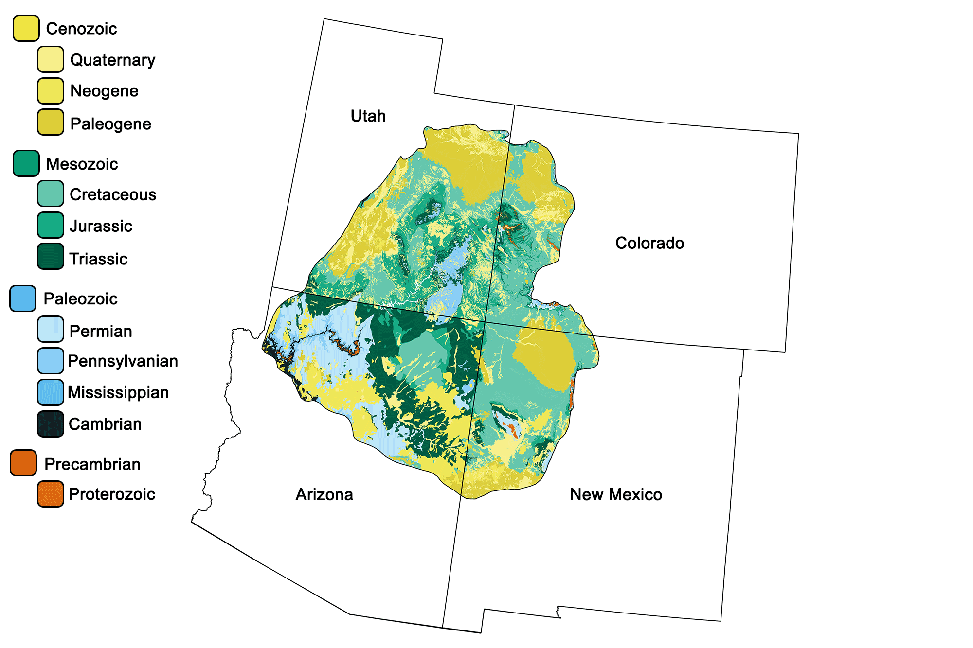
Geologic map of the Colorado Plateau region of the southwestern United States showing maximum ages of mappable units. Image by Jonathan R. Hendricks for the Earth@Home project developed using QGIS and USGS data (public domain) from Fenneman and Johnson (1946)and Horton et al. (2017).
Overview
The Colorado Plateau is an arid region that developed as a stable crustal block. It was not significantly affected by either the compressional forces that gave rise to the Rockies or by the Cenozoic extensional forces that produced the Basin and Range. Between eight and five million years ago, an epeirogenic (vertical) uplift raised the entire region as a single block to its present elevation of 610–4000 meters (2000–13,000 feet). Despite its name, the Colorado Plateau is not a flat area, but rather a landscape of contrasting features and colors, including dramatic sheer-walled canyons, wind- and water-sculpted formations, towering monoliths, and flat-topped mesas. It is perhaps the best place to examine a nearly continuous sequence of representative Southwestern sedimentary layers.
The region embodies the quintessential Old West, and includes many of the landscape features so often seen in the backdrop of films and books. Interesting rocks and breathtaking vistas can be found almost anywhere on the plateau, which has the highest density of national parks and monuments in the country.
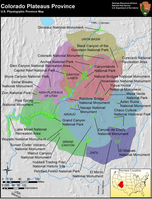
Locations of some national parks and monuments in the Colorado Plateau. The region hosts 10 national parks, 27 national monuments, 19 national forests, and 57 state parks. Image by the National Park Service (public domain).
Precambrian
The Colorado Plateau is underlain by Precambrian basement rock, which is exposed in the deep gorge of Arizona’s Grand Canyon as well as at the edge of Colorado’s San Juan Mountains. The schists and gneisses found in the Needle Mountains (a subrange of the San Juan Mountains), and at the base of the Grand Canyon, are 1.9 to 1.7 billion years old and comprise metamorphosed volcanic and marine sedimentary rocks. These rocks are the product of plate tectonic activity from the collision and accretion of a volcanic island arc, the Yavapai terrane, with what was then a much smaller North American continent. Igneous rock bodies, such as the Zoroaster Granite were intruded into the plate at approximately the same time. These ancient rocks are overlain by a thick sequence of mildly metamorphosed sedimentary layers known as the Grand Canyon Supergroup, a series of sandstones, shales, and limestones that constitutes one of the most complete middle-to-late Proterozoic geologic records in North America.
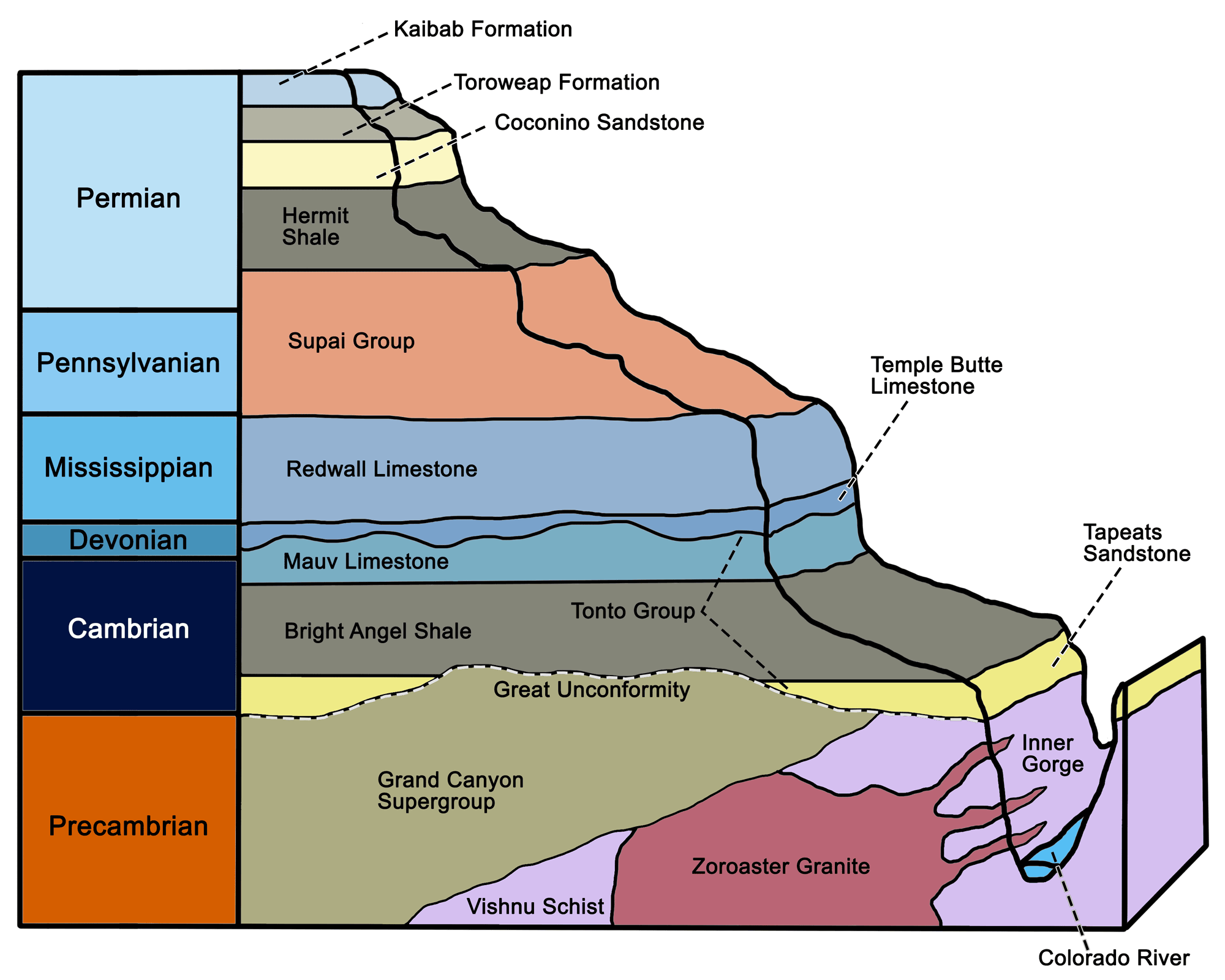
Major Paleozoic stratigraphic units of the Grand Canyon and Colorado Plateau. Image by Wade Greenberg-Brand, modified for the Earth@Home project.
These rocks were generated approximately 1.2 to 1.1 billion years ago during the formation of the supercontinent Rodinia, when they were compressed from sedimentary layers originally deposited in fluvial and shallow marine environments. Basalt sills and dikes were intruded throughout the Grand Canyon Supergroup as a result of volcanic activity during the late Proterozoic.
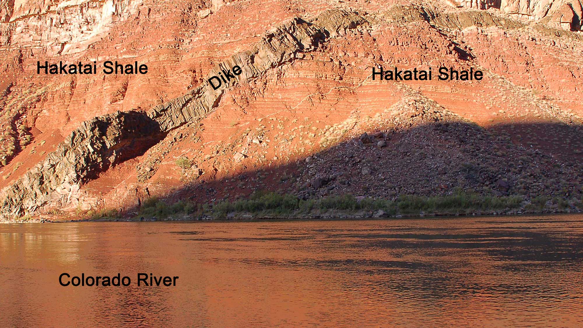
A basalt dike intruded into the orange-red Hakatai Shale, part of the Grand Canyon Supergroup. This exposure is found at Hance Rapid on the Colorado River, Grand Canyon. Photograph by Grand Canyon National Park (Flickr; Creative Commons Attribution 2.0 Generic license).
Overall, these layers record a long history—perhaps 200 million years—between the Precambrian formation of continental crust by terrane accretion and the more familiar events of the Cambrian Period and later.
The Great Unconformity
Overlying the uppermost layers of the Grand Canyon Supergroup is one of the most conspicuous features of the rocks in the Grand Canyon, an irregular level called “the Great Unconformity.”
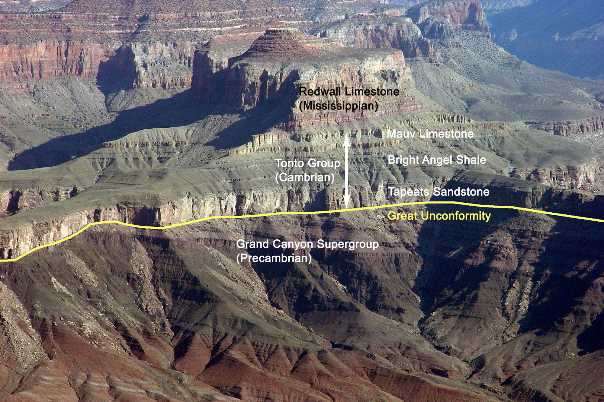
The Great Unconformity (marked by the line) in the Grand Canyon, Arizona, where the horizontal Tonto Group (Cambrian) overlies the tilted Grand Canyon Supergroup (Proterozoic). Image by Jonathan R. Hendricks for the Earth@Home project.
The Great Unconformity preserves a gap in the geological record where stratified layers have been interrupted or destroyed due to erosion or deformation. It is one of the most widely recognized and distinctive stratigraphic surfaces in the entire rock record. The unconformity separates rocks of Precambrian age from those of the Paleozoic Era, and is part of a continent-wide feature that extends across the ancient core of North America. The length of time represented by the Great Unconformity varies along its length—in some parts of the Grand Canyon, a period of 175 million years is “missing” between the Cambrian Tonto Group sandstones and the Precambrian Grand Canyon Supergroup. In other places, there is a gap of over 1.2 billion years where the 550-million-yearold Tapeats Sandstone rests on 1.7-billion-year-old basement rock.
Geologists are still unsure of the Great Unconformity's exact origin, but it may have been caused by a major episode of continental uplift following the formation of the North American craton. This uplift would have exposed the continent—then completely barren of life—to extensive erosion, degrading the rocks for hundreds of millions of years before they were submerged by a shallow sea in the Cambrian.
The Great Unconformity is one of the most prominent sections of “missing time” in North America, but there are other examples of unconformities throughout the U.S. The absence of rocks deposited during certain time periods does not mean that no rocks were formed during that time. It may mean, however, that very little sediment was deposited, that the sediment was eroded away, or that the rocks are buried beneath the surface. There is no single place on Earth with a complete sequence of rocks from the Precambrian to the Quaternary. Erosion and weathering over time have removed many meters (feet)—and in some cases kilometers (miles)— of rock from the surface of the Southwest.
Paleozoic
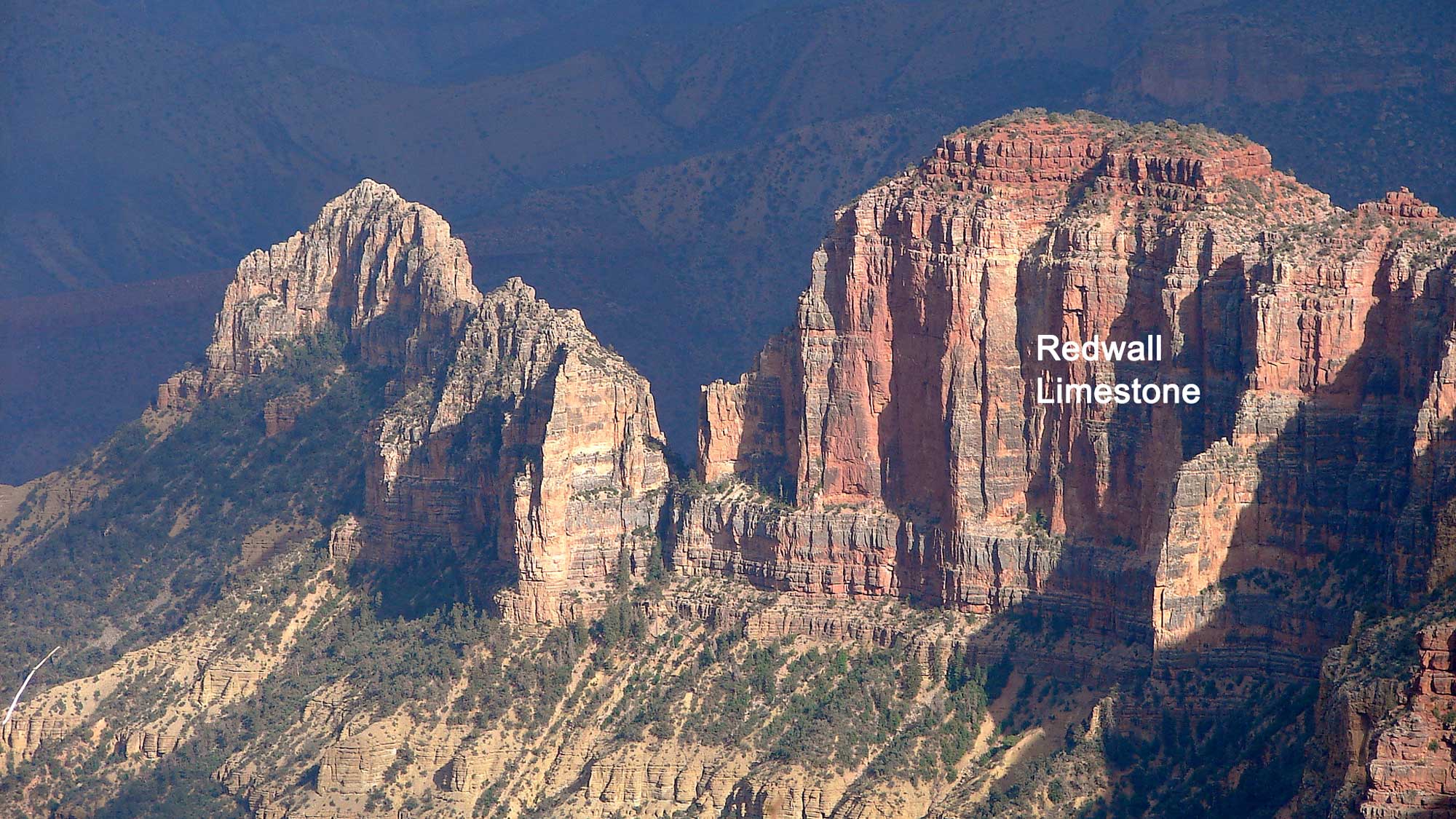
From near the bottom of the Grand Canyon, up through younger layers observed farther east, these rocks tell the story of the entire Paleozoic. Cambrian strata of the Tonto Group comprise a sequence of tan, gray, and brown sandstone, mudstone, and limestone that represent an approaching shoreline (Tapeats Sandstone) and offshore mud layers (Bright Angel Shale, Muav Limestone). Late Devonian layers of gray and tan limestone are referred to as the Temple Butte Formation, and they were laid down in an environment similar to that of the modern Yucatan. Sea level rose from the Ordovician through Mississippian periods, and Mississippian rocks are widespread across much of Arizona and New Mexico, where they typically form prominent cliffs that dominate the landscape. Orogenic activity to the northwest (in what is now western Nevada) had little effect on Arizona’s clear, warm, shallow marine carbonate shelf. Here, the Mississippian Redwall Limestone is one of the most conspicuous rock layers, forming towering vertical cliffs in the Grand Canyon.
Original caption: "Late Afternoon, Eastern Grand Canyon. Cliffs of Redwall Limestone from the Saddle Mountain Trailhead in the Kaibab National Forest, Grand Canyon North Rim." Photograph by Jesse Varner (Flickr; Creative Commons Attribution-NonCommercial-ShareAlike 2.0 Generic license; image cropped and label added).
Although its name implies that the limestone is red, it is actually gray. The visible portions of the Redwall Limestone have been stained red from the erosion of iron-rich sediments in the overlying Supai Group and Hermit Formation, which have washed down across the limestone over time and been absorbed into its surface.
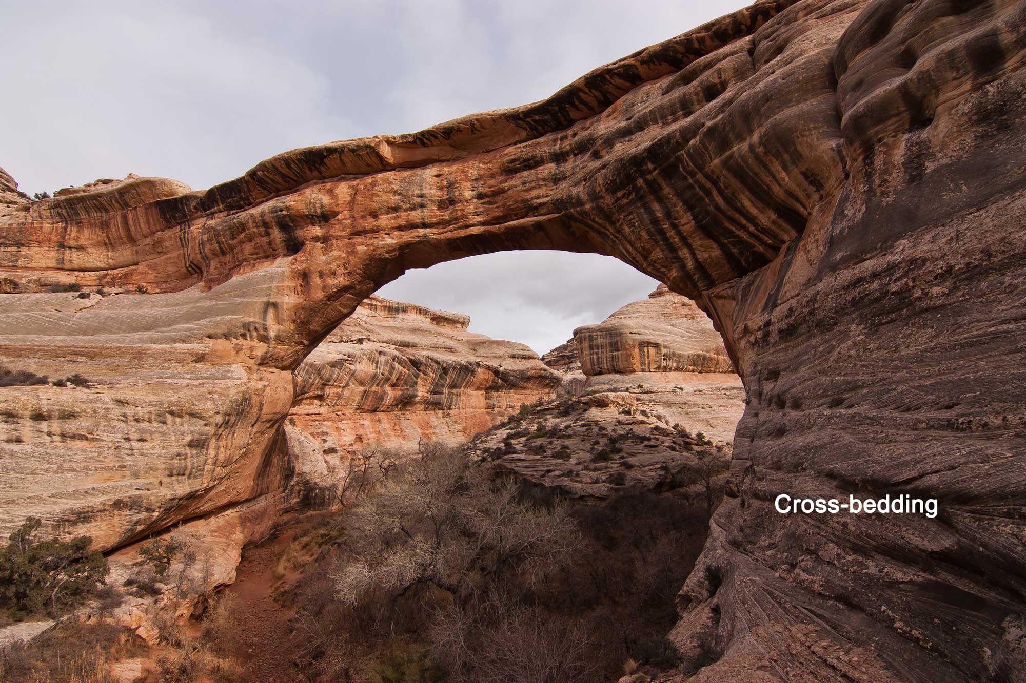
The Pennsylvanian and Permian periods—the last 70 million years of the Paleozoic era—were marked by uplift and falling sea level across the Southwest, both of which led to the expansion of terrestrial environments. The Redwall Limestone was exposed to subaerial erosion, forming karst topography. Streams carved valleys into the limestone, and estuarine deposits flooded the valleys as fills during subsequent transgressions. Uplifted areas shed large volumes of sediment, forming thick deposits in adjacent basins. The heavy influx of sand and mud resulted in preservation of these and other continental sediments as red beds (such as the Hermit Shale), colored by the oxidation of iron minerals. At this time, the region was near the equator, and an arid climate led to the widespread formation of sand dunes. Today, extensive coastal, windblown (aeolian) sand dune fields are preserved as thick beds of sandstone, with large-scale cross-bedding.
The late Pennsylvanian Manakacha Formation, in the lower Supai Group, documents the earliest influx of aeolian sand onto what later became the Colorado Plateau. Permian dune sands include the Cedar Mesa Sandstone exposed in Natural Bridges National Monument, the Needles district of Canyonlands National Park, and the bright pale-yellow Coconino Sandstone visible in Arizona and Utah.
Sipapu Natural Bridge, formed from Cedar Mesa Sandstone in Natural Bridges National Monument, Utah. Note the cross-bedding at lower right. Photograph by Xavier Lambrecht (Flickr; Creative Commons Attribution-NonCommercial 2.0 Generic license; image resized and label added).
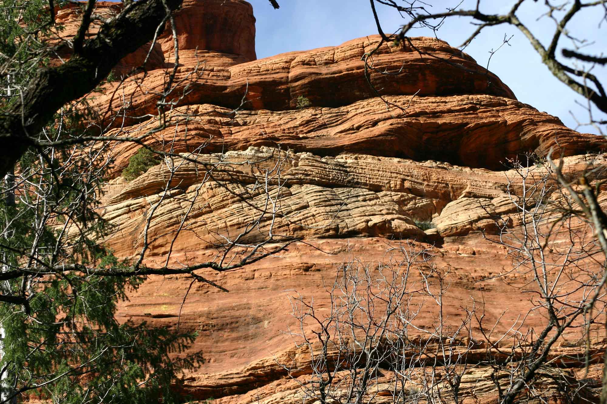
Cross-beds in the Coconino Sandstone at Sedona, Arizona. Photograph by Kevin Walsh (Flickr; Creative Commons Attribution 2.0 Generic license; image resized).
Along the coasts of shrinking inland seas, salt flats grew along arid coastlines. These newly formed sabhka environments became sites of abundant deposition for evaporite minerals, including salt, gypsum, and anhydrite. Thick sequences of alternating evaporites and shales accumulated in basins across the region, as shallow marine water evaporated and deposited layers of salt. The Paradox Basin in southeastern Utah is best known for its salt deposits; it also contains oil reserves and copper.
Mesozoic
By the end of the Permian period, the supercontinent Pangaea had formed, and the Southwest was largely a terrestrial environment. The Mesozoic era generated a succession of near-shore and continental deposits, mostly sandstones and shales, which form the spectacular cliffs and mesas seen throughout much of the Colorado Plateau. Similarly to the way the entire Paleozoic is exposed at the Grand Canyon, the Mesozoic and part of the Cenozoic are beautifully exposed in the Grand Staircase. This immense sedimentary sequence stretches south from Bryce Canyon National Park in Utah to the edge of the Grand Canyon.
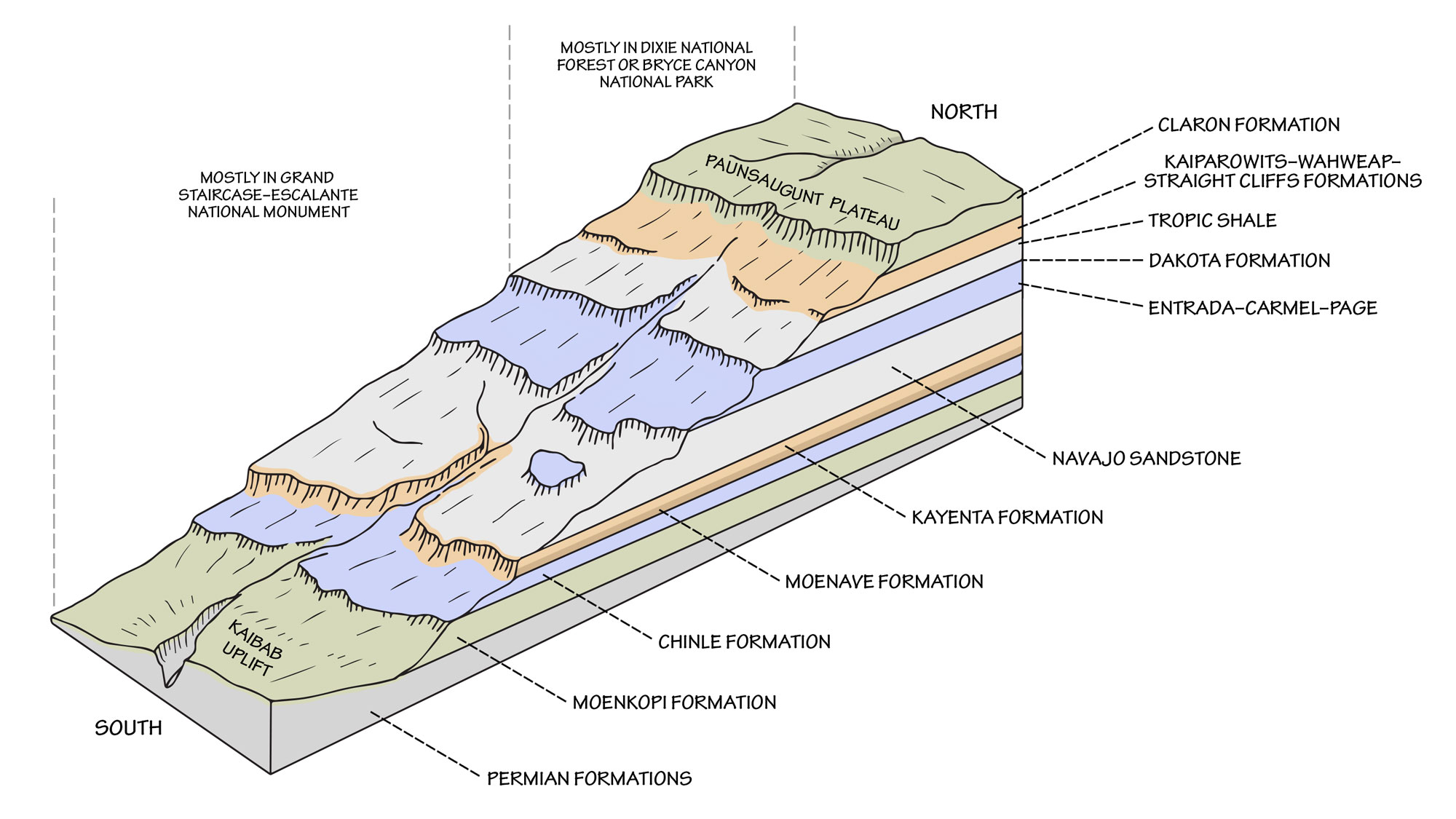
Major Mesozoic and Cenozoic stratigraphic units of the Grand Staircase and Colorado Plateau. Image by Wade Greenberg-Brand, adapted from image by Doeling et al. (2000), Geology of Grand Staircase-Escalante National Monument, Utah, Utah Geological Association Publication 28.
Many Mesozoic sandstones, especially those from the Triassic, have a reddish color caused by the oxidation of iron within the rock. For example, the Triassic Moenkopi Formation consists of reddish-brown, fine-grained sandstone and mudstone. It represents both shallow marine and near-shore terrestrial environments. Terrestrial features of the Moenkopi, such as ripple marks, mud cracks, and scour marks, point to an arid environment prone to flash floods. Stream channels, flood plains, fresh or brackish ponds, playas, and shallow marine environments can also create similar traces.
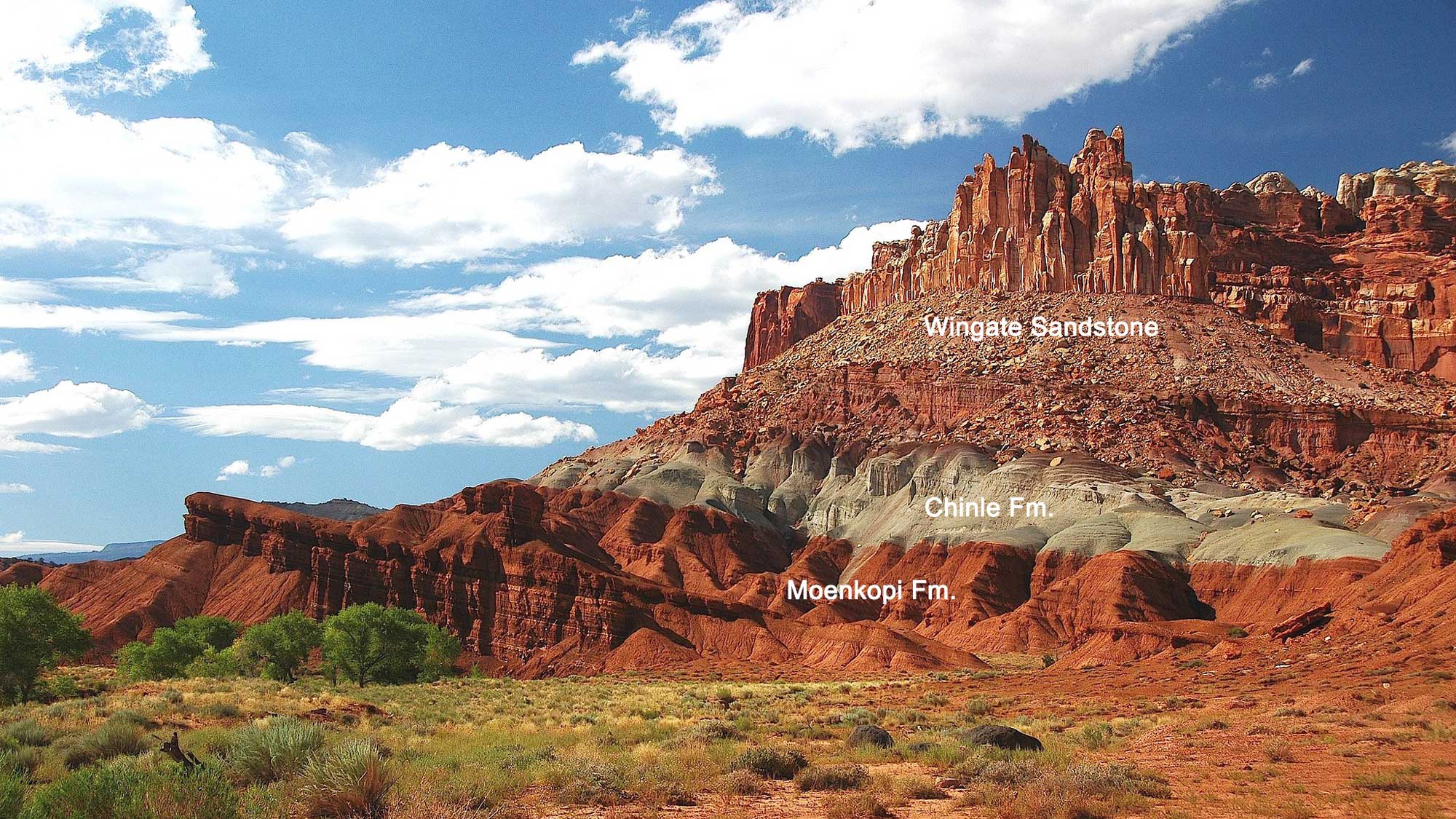
Triassic sediments at The Castle, Capitol Reef National Park, Utah. Three strata are visible here: the Wingate Sandstone (top), the Chinle Formation (middle), and the Moenkopi Formation (bottom). Photograph by James St. John (Flickr; Creative Commons Attribution 2.0 Generic license); image resized and labels added).
Above the Moenkopi, the Chinle Formation consists of diverse sandstones, mudstones, and conglomerates deposited in a somewhat wetter environment—low-relief rivers and lakes. The Chinle is famous for its colors, ranging from various shades of reds, blues, and pinks to grays, tans, and browns. It is also famous for its fossils, which include abundant trees (e.g., Petrified Forest National Park) and dinosaurs.
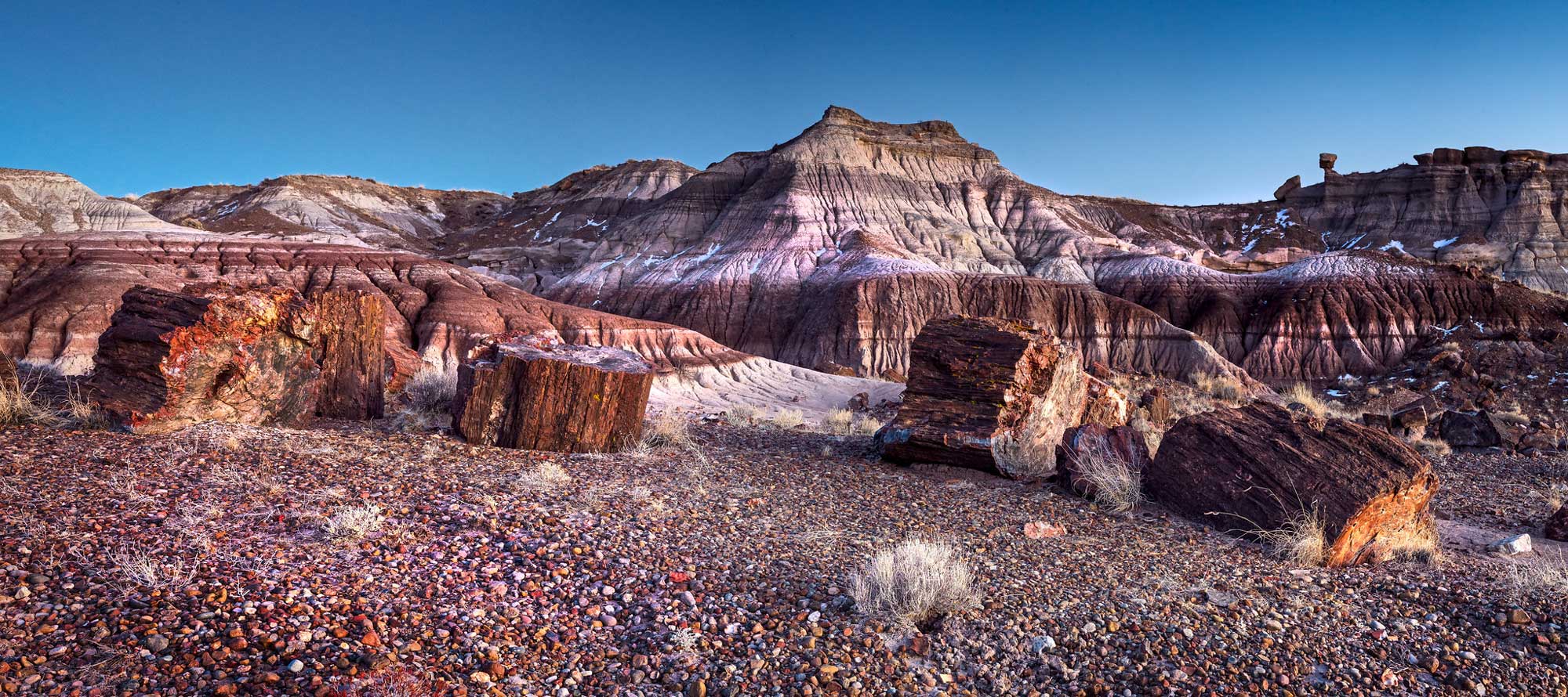
Exposure of the Triassic Chinle Formation at Petrified Forest National Park in Arizona, with petrified wood in the foreground. Photograph by Andrew Kearns (Flickr; Creative Commons Attribution 2.0 Generic license; image resized).
Pangaea began to break up during the early Jurassic. At this time, vast sand dune fields covered much of the Southwestern US, forming thick cross-bedded layers of sandstone. The early Jurassic sediments of the Colorado Plateau represent some of the world’s best geological records from this time interval. These sediments are collectively called the Glen Canyon Group, which includes (from older to younger) the Wingate/Moenave, Kayenta, and Navajo formations. The Moenave and Navajo represent aeolian sediments, while the Kayenta, sandwiched in between them, consists of siltstones and sandstones that were deposited in braided and meandering streams.
The Jurassic dune-forming environment (called a “sand sea” or erg) is best seen in the Navajo Sandstone, which is exposed widely across northern Arizona and southern Utah.
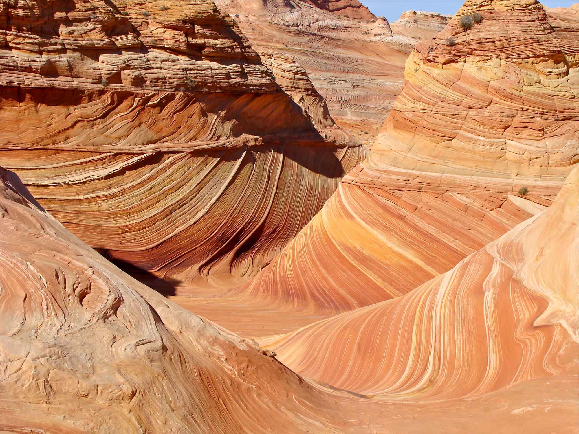
The Wave, a series of intersecting U-shaped troughs eroded into Jurassic Navajo Sandstone within the Paria Canyon-Vermilion Cliffs Wilderness, Arizona. The cycling layers in the sandstone represent changes in the direction of prevailing winds as large sand dunes migrated across the desert. Photograph by Julia Manzerova (Flickr; Creative Commons Attribution-NonCommercial-ShareAlike 2.0 Generic license; image resized).
The Navajo, together with the Nugget and Aztec sandstones to the north and southwest, represents one of the largest ancient sand dune deposits on Earth, covering more than 150,000 square kilometers (58,000 square miles)—an area approximately the size of Illinois.
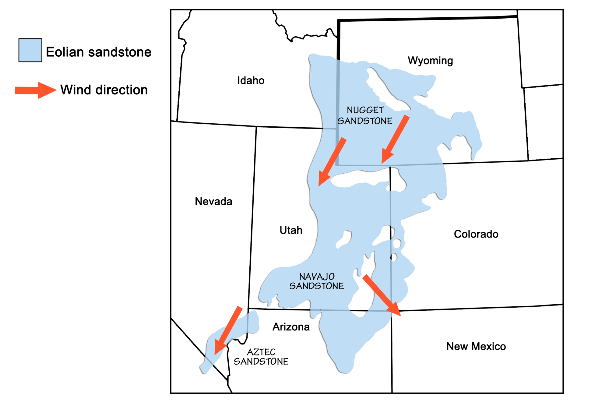
Extent of the Navajo, Nugget, and Aztec sandstones, with arrows showing the direction of wind in the dune-forming environment. Image by Wade Greenberg-Brand and modified for Earth@Home project, in turn adapted from image by Chan and Archer (2000), Cyclic Eolian Stratification on the Jurassic Navajo Sandstone, Zion National Park: Periodicities and Implications for Plaeoclimate, Utah Geological Association Publication 28.
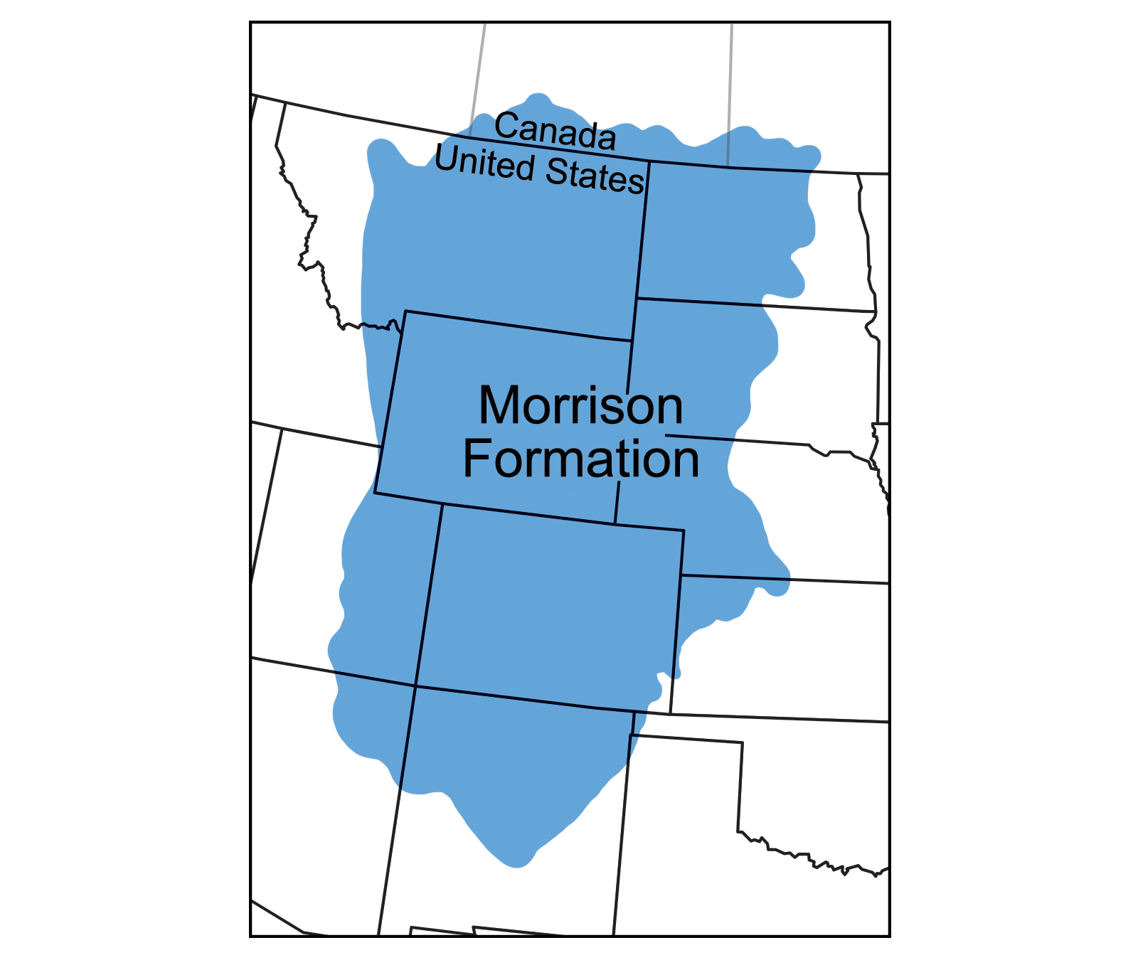
By the late Jurassic, the Colorado Plateau contained a complex environment of coastlines, rivers, lakes, marshes, ponds, floodplains, and dunes. The Morrison Formation, a series of variegated mudstones and shales, was deposited in mixed mud flats, river channels, and lakes. Dinosaur bones and trackways are often found in the Morrison’s relict stream channels (learn more about Morrison Fm. fossils here).
During the Cretaceous period, the interior of North America was downwarped by tectonic processes associated with the subduction of oceanic lithosphere along the western edge of the continent. As the Laramide and Sevier orogenies occurred to the west, the North American interior was flooded by a particularly vast inland sea called the Western Interior Seaway.
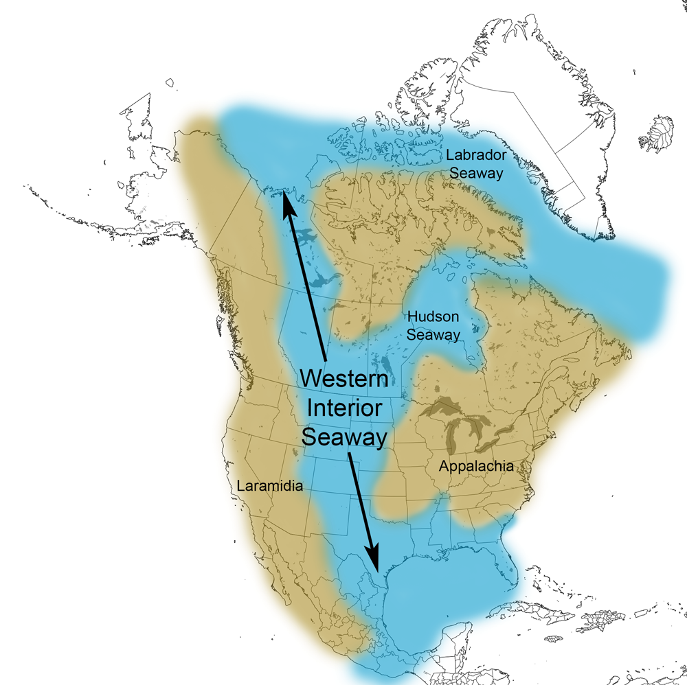
The Western Interior Seaway. Image by Jonathan R. Hendricks.
The Dakota Sandstone, formed from beach sand, signals the onset of this sea. Ripple marks created by currents or waves are common in these sediments, indicating wave action at or near a beach.
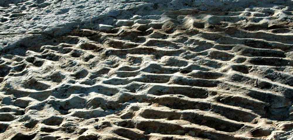
Ripple marks in the Dakota Sandstone of Dinosaur Ridge, Colorado. Photograph by James St. John (Flickr; Creative Commons Attribution 2.0 Generic license; image resized).
In Colorado, at Morrison and along the Purgatoire River, spectacular dinosaur trackways are preserved in these sandstones (see Rocks of the Rocky Mountains page).
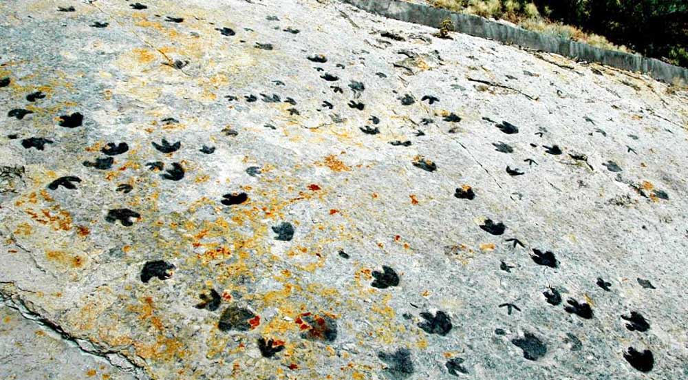
Dinosaur footprints in the Cretaceous Dakota Sandstone at Dinosaur Ridge, Colorado. Photograph by James St. John (Flickr; Creative Commons Attribution 2.0 Generic license; image resized).
As the water deepened, thick sequences of shale (the Mancos Shale) were deposited. When the sea again retreated at the end of the Cretaceous, more sandstones (the Mesaverde Formation) were laid down. During the 12th and 13th centuries, the Ancestral Puebloan peoples of Colorado carved massive, elaborate dwellings and other structures into these sandstones.
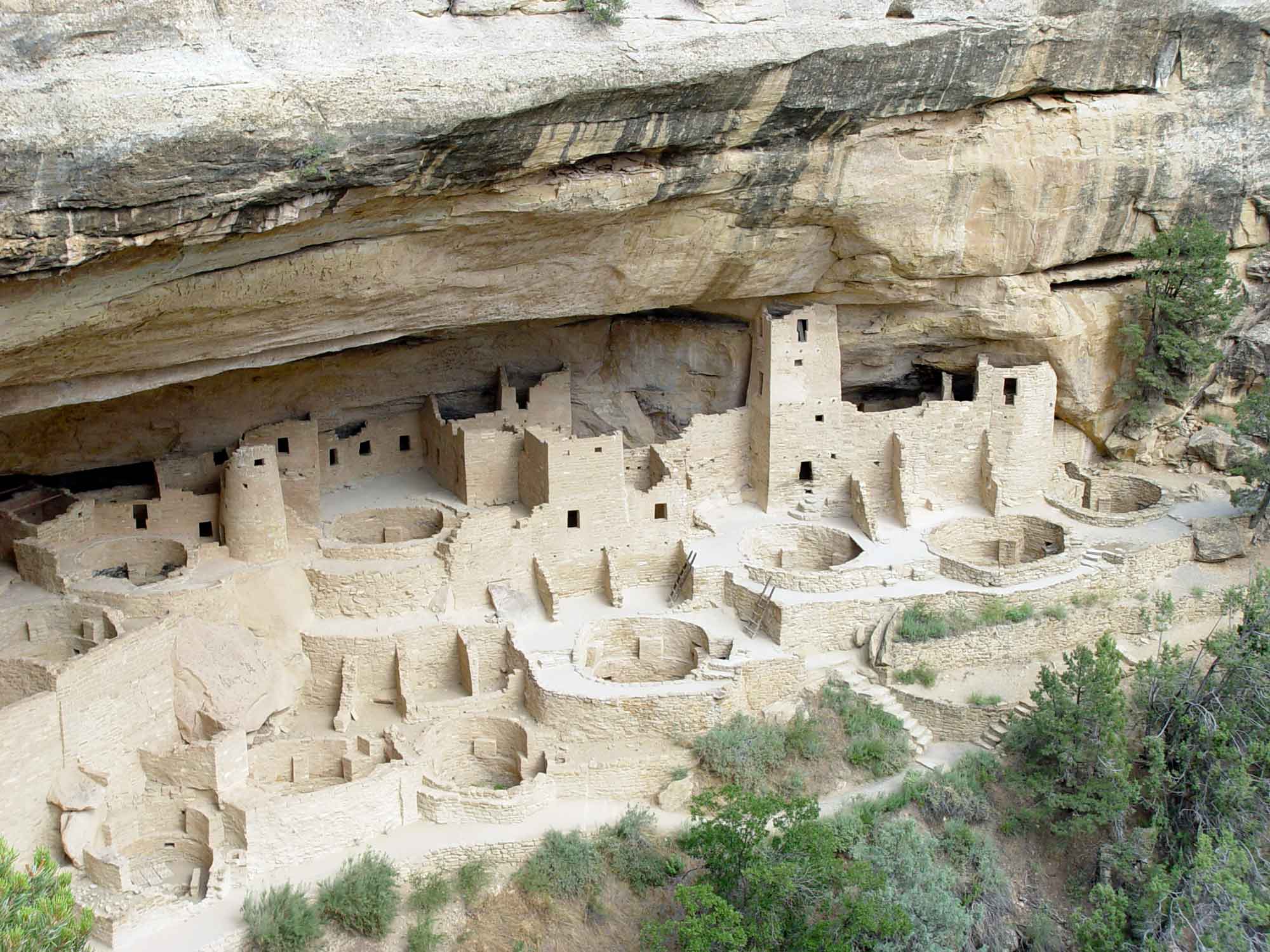
Cliff Palace, the largest cliff dwelling in North America, at Mesa Verde National Park, Colorado.
Cenozoic
Throughout the Cenozoic Era, mountains that had formed during the Sevier and Laramide orogenies experienced significant erosion. Cobbles, sand, and mud were carried by streams and deposited into rivers and lakes, forming conglomerate, sandstone, mudstone, and shale. Large basins— areas of the crust that slowly subside, or sink—on the Colorado Plateau received thick layers of sediment that became sources and reservoirs for oil and gas. Swamps and lowlands on basin margins formed widespread coal beds. During the Eocene period, sediment accumulated in floodplains, shallow lakes, rivers, and soils to form the Claron Formation, a set of varied conglomerates, sandstones, mudstones, and carbonates stained by iron to produce a distinctive pinkish hue. These layers alternate between less and more resistant rocks, such that weathering produces wavy vertical profiles leading to hoodoos and badlands topography.
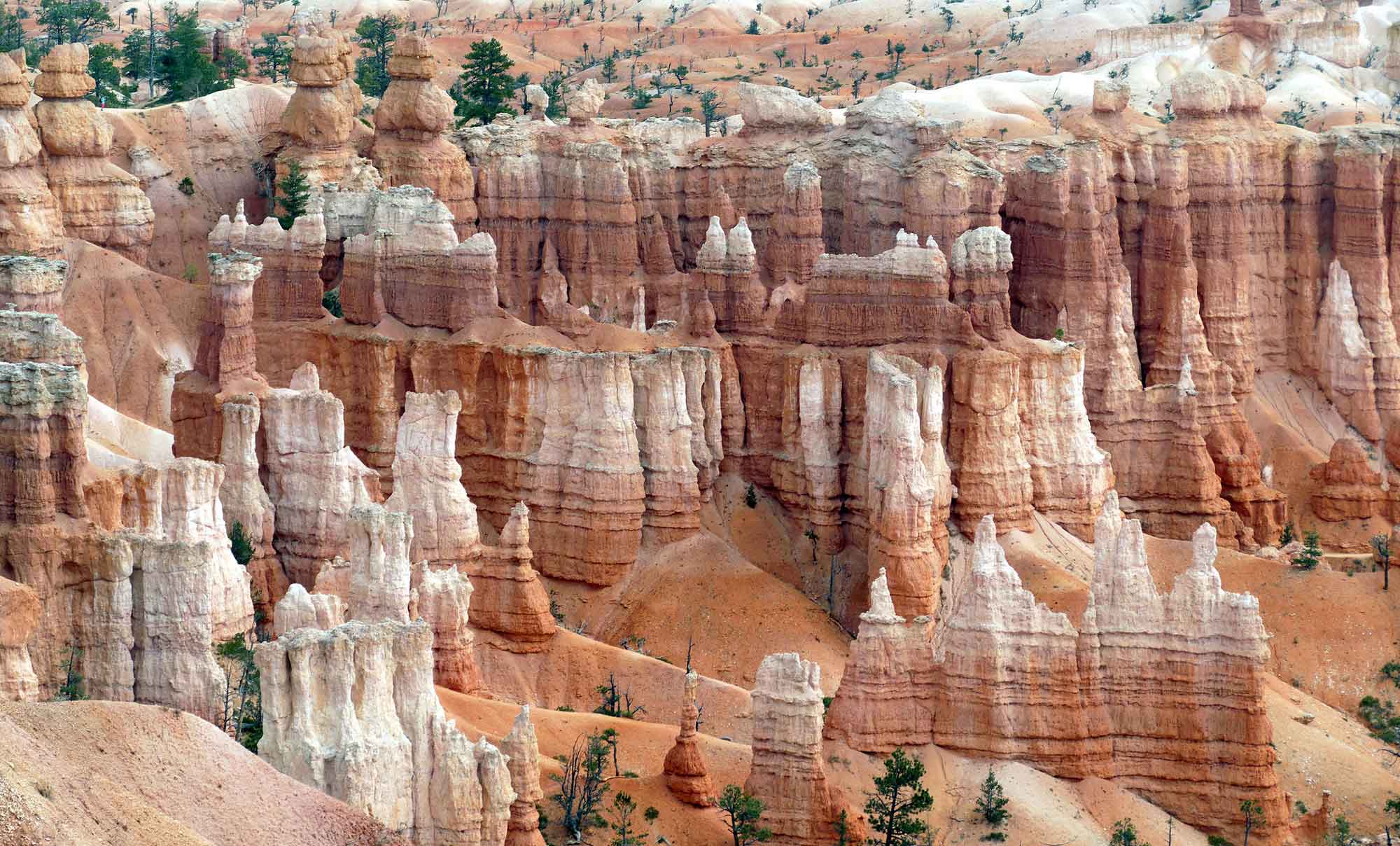
The Eocene Claron Formation is prominently exposed in the cliffs and hoodoos (tall, skinny spires of rock) of Bryce Canyon, Arizona. Vertical joints through the rocks have become weathered through frost wedging, leading to the formation of hoodoos. Photograph by Bernard Spragg (Flickr; public domain).
Hoodoos form when weathering erodes a softer material out from underneath a mass of harder capstone, leading to "mushroom" formations.
Many of the Colorado Plateau’s volcanic rocks occur around the region’s edges, and are attributed to Cenozoic volcanism spurred by the formation of the Basin and Range. For example, the southeast margin of the Plateau, in New Mexico, is covered by Neogene volcanic rocks that erupted along an ancient suture zone called the Jemez Lineament.
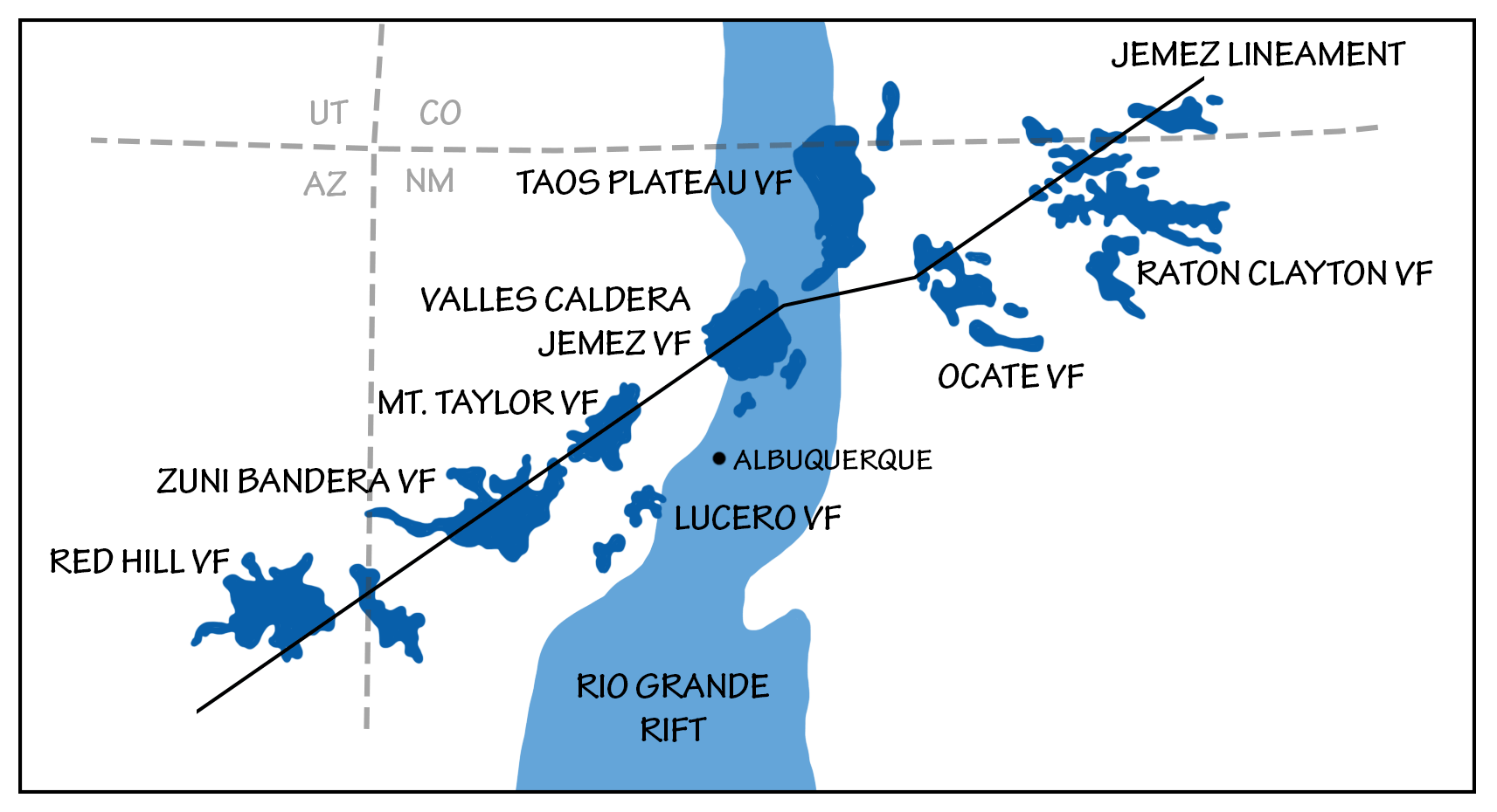
The Jemez Lineament and associated volcanic fields. Image by Wade Greenberg-Brand, adapted from image by Goff and Janik (2002), Gas geochemistry of the Valley Caldera Region, New Mexico and comparisons with gases at Yellowstone, Long Valley and other geothermal systems, Journal of Volcanology and Geothermal Research, 166(3-4): 299-323.
The Mt. Taylor volcanic field in New Mexico, part of this igneous zone, contains trachyte, tuff, pumice, rhyolite, basalt, and other volcanic flows and deposits. The field is scattered with volcanic necks, the solidified erosional remnants of volcanoes. The Valles Caldera, a small supervolcano also located along the Jemez Lineament, erupted several times between 1.5 million and 60,000 years ago, forming thick layers of solidified volcanic ash and tuff. Supervolcanoes—volcanoes capable of producing more than 1000 cubic kilometers (240 cubic miles) of ejecta—can occur when magma rises under the crust from a hot spot, but is unable to break through. Eventually, the crust ruptures when it can no longer contain the built-up pressure. The ashfall from the eruption 1.2 million years ago blanketed an area roughly 800 by 1300 kilometers (500 by 800 miles) in extent.
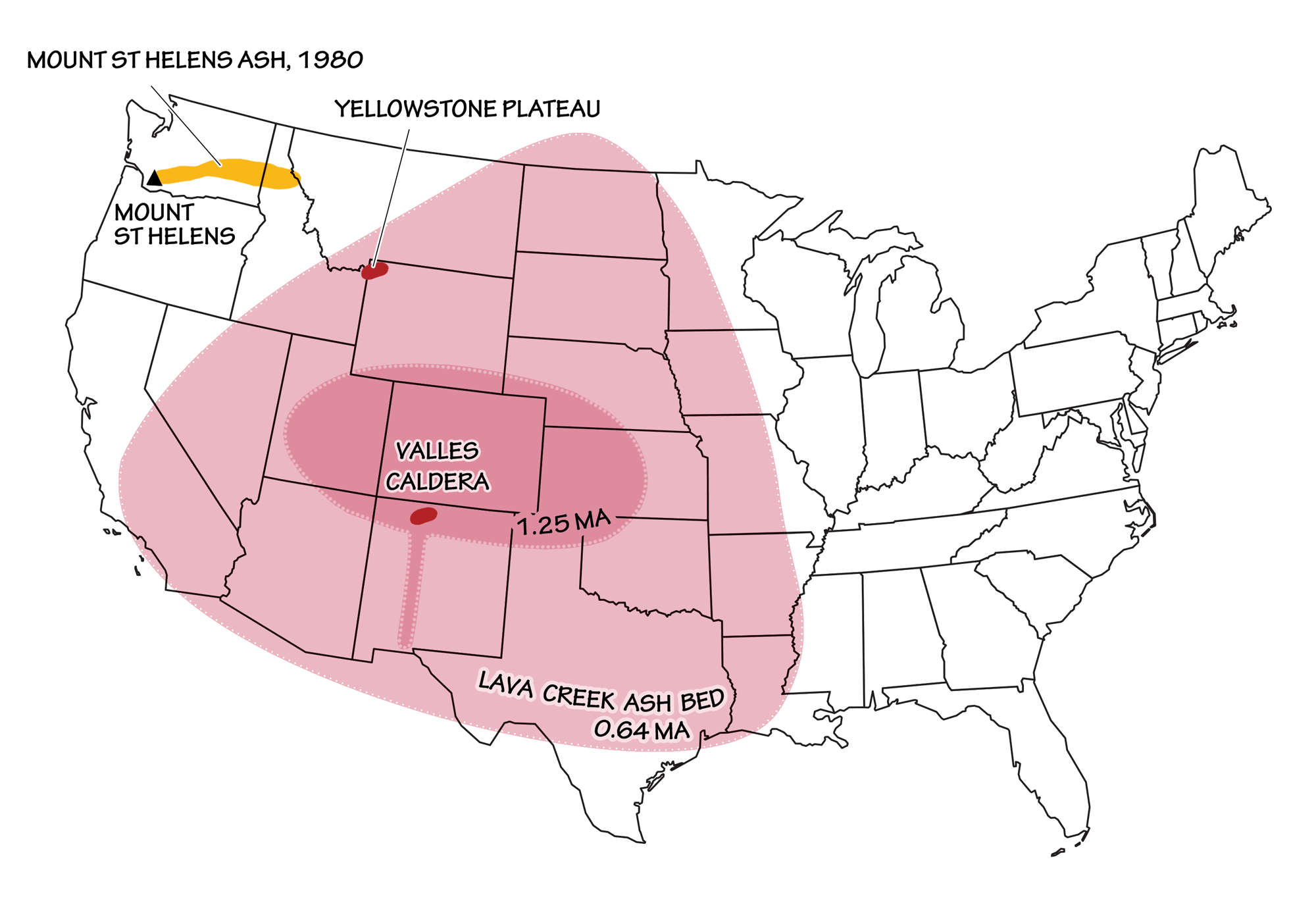
Extent of ashfall from the Valles Caldera, as compared to the Lava Creek Ash Bed from Yellowstone and the eruption of Mt. St. Helens. Image by Wade Greenberg-Brand, adapted from image by USGS.
The Bandelier Tuff is one such layer, formed as extremely hot dust and ash poured out of the Valles Caldera and flowed down its side in thick layers of tuff. The ancient Ancestral Pueblo peoples built pueblos and dwellings against these cliffs, and also carved rooms from the soft rock.
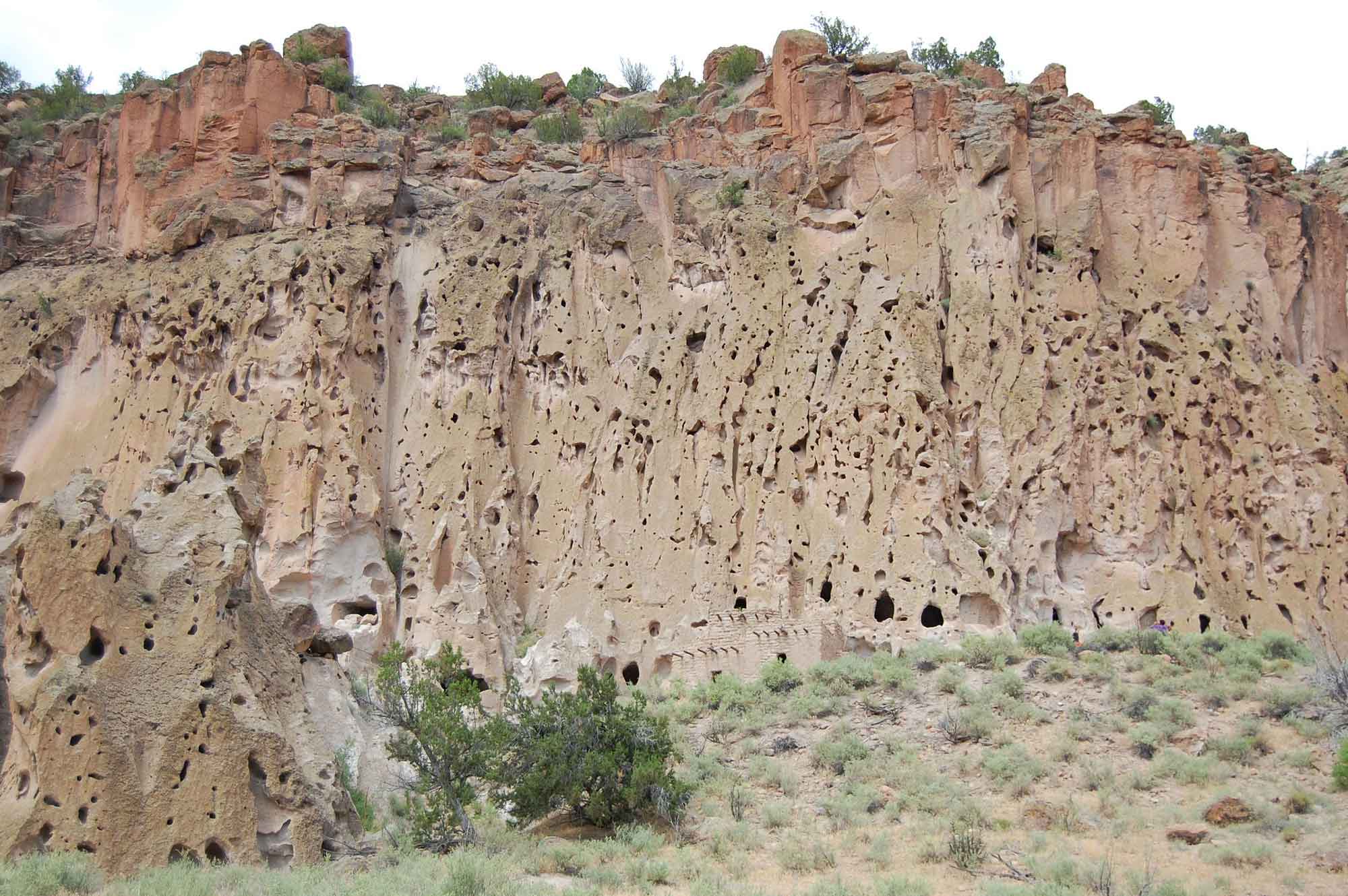
The Bandelier Tuff, a Pleistocene-aged mixture of volcanic tuff and pumice, at Bandelier National Monument in New Mexico. Photograph by Stephanie Fitzgerald (Flickr; Creative Commons Attribution-NonCommercial-ShareAlike 2.0 Generic license; image resized).
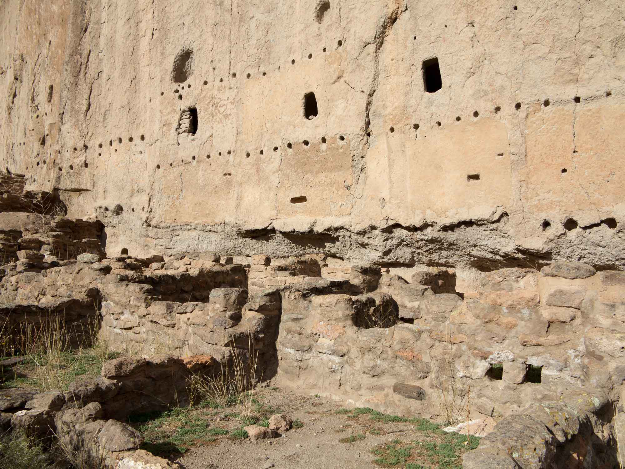
Dwellings of ancient Puebloan people carved into and built out of Bandelier Tuff at Bandelier National Monument in New Mexico. Photograph by Alex Derr (Flickr; Creative Commons Attribution-NonCommercial-ShareAlike 2.0 Generic license).
A few notable volcanic deposits are located more centrally within the Colorado Plateau, mainly in the form of volcanic fields. The Navajo Volcanic Field includes over 80 Oligocene to Miocene volcanoes (approximately 28 to 19 million years old) and associated intrusive igneous rocks that are found in an arc across the region. The rocks in the Navajo Volcanic Field are unusual because they are very potassium rich and highly mafic (probably forming from mantle magma). Many of the rocks are composed of minette, which contains biotite (mica with potassium) and orthoclase (potassium feldspar). Xenoliths—rocks from older layers incorporated into the magma—are common, and include rocks from both the crust and upper mantle. Uplift and weathering of the Colorado Plateau exposed these volcanic rocks, including dikes, pipes, necks, sills, and other features formed at the base of volcanoes. Differential weathering produced distinctive landforms such as Shiprock, a volcanic neck made of tuff and breccia in northwest New Mexico.
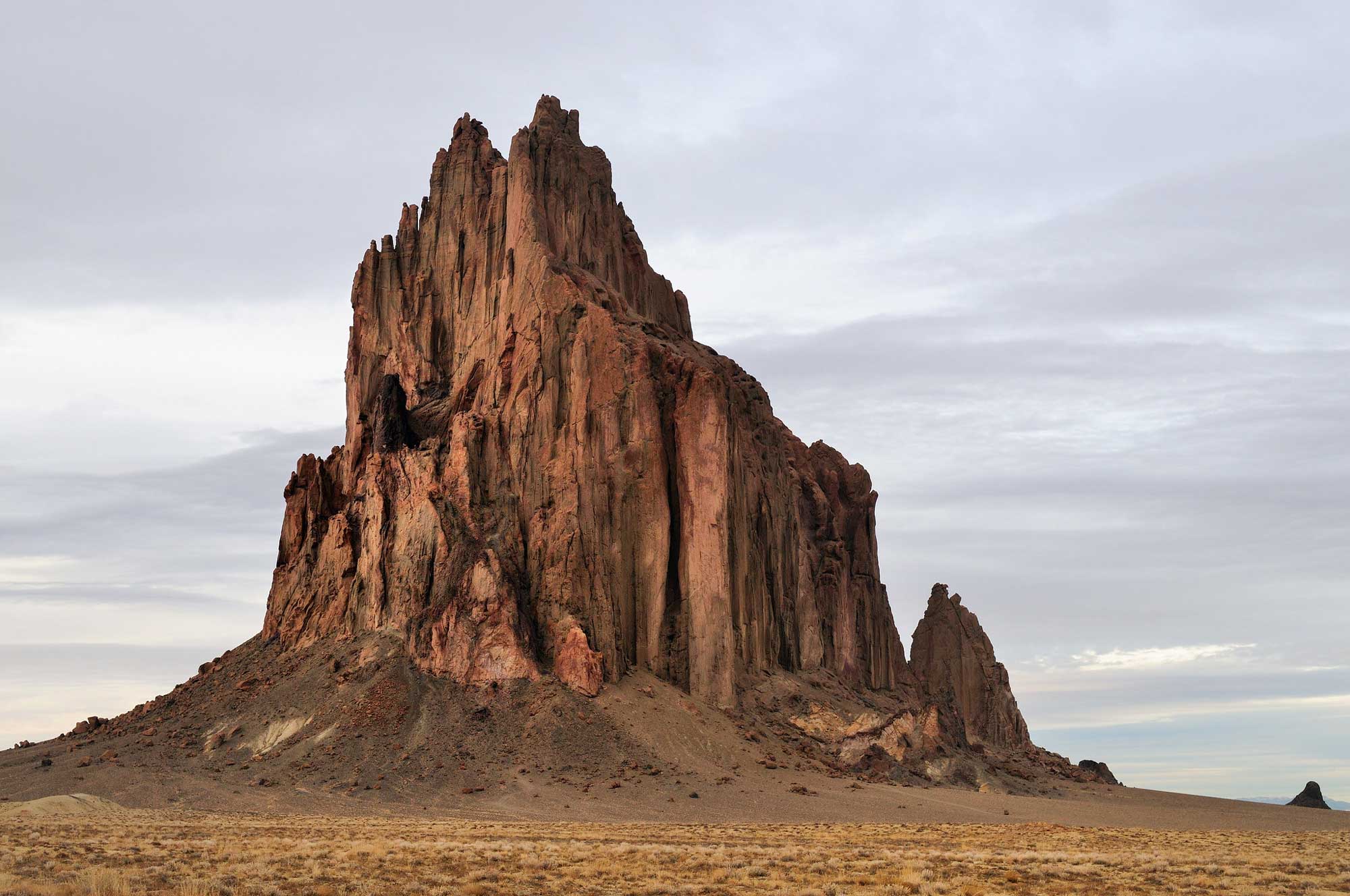
Shiprock, a volcanic monadnock in San Juan County, New Mexico, rises roughly 483 meters (1583 feet) above the desert plain. Photograph by "Cathy" (Flickr; Creative Commons Attribution-NonCommerical 2.0 Generic license).
The volcanic crater associated with Shiprock may have been as much as a kilometer (0.6 miles) above the current land surface; the rock itself formed nearly 1000 meters (3000 feet) underground and was eventually exposed after millions of years of erosion. The Uinkaret Volcanic Field, on the north rim of the Grand Canyon, is one of the region’s youngest volcanic areas, with igneous rock ranging from 1.2 million years to only 1000 years old. Here, massive basalt lava flows cascaded down into the Grand Canyon, occasionally blocking the Colorado River.
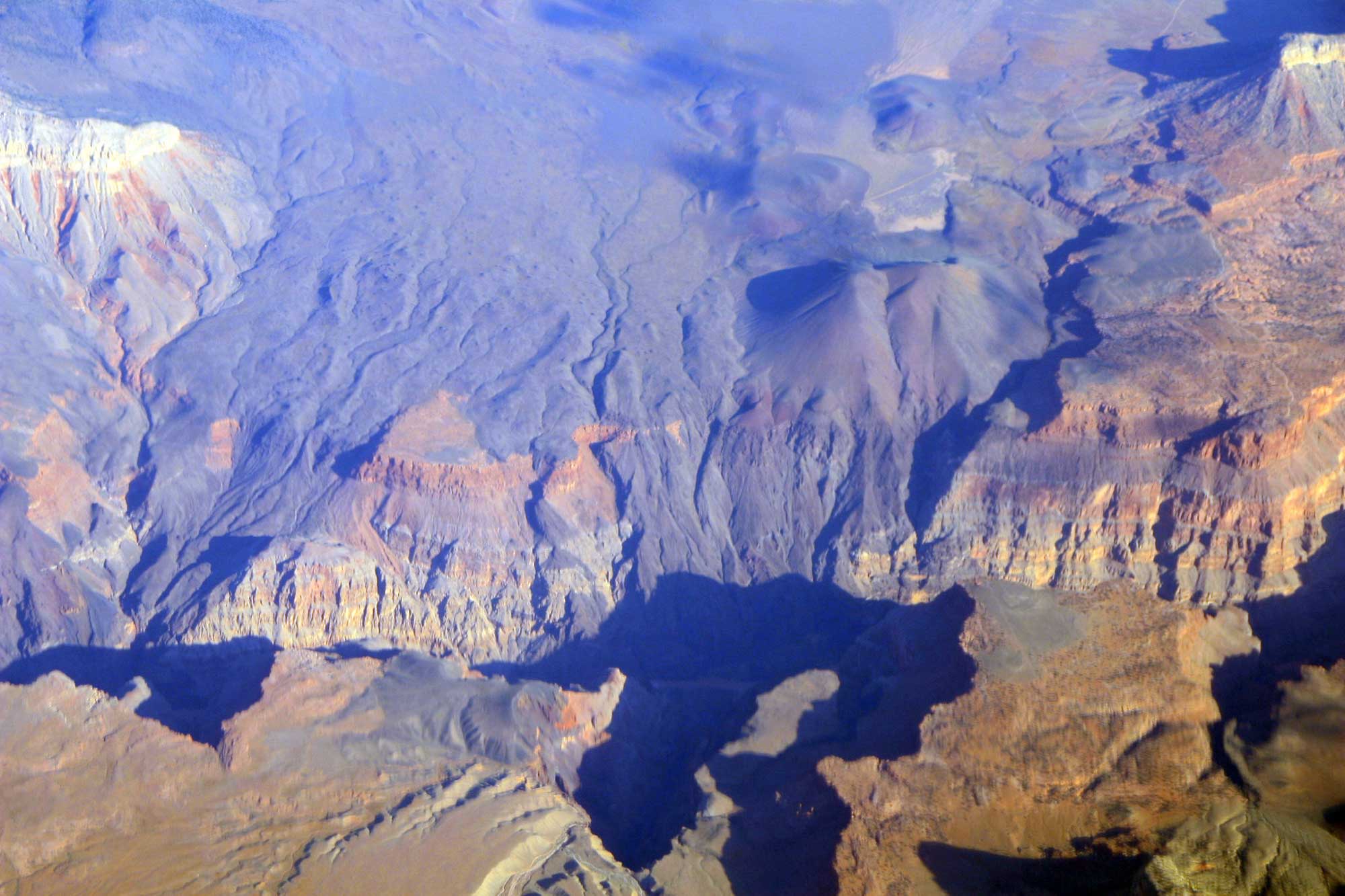
In this aerial view, the black basalt of the Uinkaret Volcanic Field is seen preserved where it cascaded over the side of the Grand Canyon at Lava Falls. Photograph by Doc Searls (Flickr; Creative Commons Attribution-ShareAlike 2.0 Generic license).
Other volcanic deposits inside the Colorado Plateau include laccoliths—dome-shaped igneous intrusions—that core the La Sal, Abajo, and Henry mountains of Utah.
There are few Quaternary-age sedimentary deposits on the Colorado Plateau. Most are related to glacial outwash from the alpine glaciers in the Rocky Mountains, as well as modern stream deposits and windblown sand and silt.
Resources
Resources from the Paleontological Research Institution
Digital Encyclopedia of Earth Science: Minerals.
Earth@Home: Introduction to Rocks.
Earth@Home: Geologic time scale.
Earth@Home: Geologic maps.
Earth@Home Virtual Collection: Rocks (Virtual rock collection featuring 3D models of rock specimens sorted by type.)