

Page Snapshot: Introduction to Earth hazards in the Southeastern United States.
Contents
Topics covered on this page: Earthquakes; Landslides; Sinkholes; Radon; Floods; Sea level rise, coastal erosion, and subsidence; Weather hazards; Climate change; Resources.
Credits: Most of the text on this page comes from "Earth Hazards of the Southeastern US" by Warren D. Allmon, Andrielle N. Swaby, and Don W. Byerly, chapter 9 of The Teacher-Friendly Guide to the Earth Science of the Southeastern US, 2nd Edition, edited by Andrielle N. Swaby, Mark D. Lucas, and Robert M. Ross (published in 2016 by the Paleontological Research Institution). The book was adapted for the web by Elizabeth J. Hermsen and Jonathan R. Hendricks in 2021–2022. Changes include formatting and revisions to the text and images. Credits for individual images are given in figure captions.
Updates: Page last updated September 28, 2022.
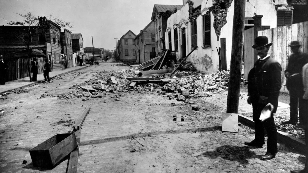
Image above: Damage resulting from the 1886 Charleston, South Carolina earthquake (USGS Photographic Library; Wikimedia Commons; public domain).
Introduction
Natural hazards or earth hazards are events or processes that have significant impacts on human beings and the environment. Extreme weather conditions or geologic activity can cause substantial short-term or long-term changes to our environment. These changes can influence many aspects of the world around us, including crops, homes, infrastructure, and the atmosphere. The 4.6-billion-year-old Earth has experienced many naturally generated hazards, while other events are byproducts of human activities, created during mineral and energy extraction or in construction practices that modify the landscape.
The Southeast is subject to a variety of earth hazards. Most famously, the area happens to have just the right combination of conditions for tornados that cross the region and hurricanes that impact the Gulf and Atlantic Coastal plains. Modifications of the Mississippi River and its mouth, as well as the Southeast's coastline, have exacerbated the impacts of storms and floods. Limestone, gypsum, and salt deposits are responsible for significant areas of karst topography and sinkholes. Like many parts of the country, landslides from expansive soils and exposure to radioactivity from radon are present, depending upon the nature of the local bedrock. Perhaps most surprisingly, despite being far from a plate boundary, certain areas of the Southeast are at risk from large earthquakes due to occasional movement along large ancient faults.
Earthquakes
Earthquakes are much less common in the eastern U.S. than in the west. This is primarily because the east coast of North America is a passive margin; that is, it is located in the center of a tectonic plate rather than at an active plate margin. All earthquakes that occur in the eastern U.S. are therefore referred to as "intraplate" earthquakes. Eastern quakes, however, are typically felt over a much larger region than western quakes of similar magnitude. For example, in the Southeast an earthquake of magnitude 5.5 can usually be felt as far as 480 kilometers (300 miles) from where it occurred, and sometimes causes damage as far away as 40 kilometers (25 miles). This appears to be because the bedrock that makes up most of the eastern U.S. is older, colder, drier, and less fractured than rocks in the western US. As a result, although earthquakes here release the same amount of energy as other earthquakes, the shaking affects a much larger area because the seismic waves travel through denser, more solid bedrock.
Notable Earthquakes of the Southeastern United States
| Date | Location | Magnitude (Mw) |
|---|---|---|
| 1886 (August 31) | Charleston, SC | 7.3 |
| 1897 (May 31) | Giles County, VA | 5.9 |
| 2011 (August 23) | Louisa County, VA | 5.8 |
| 1916 (February 21) | Waynesville, SC | 5.2 |
| 1980 (July 27) | Sharpsburg, KY | 5.2 |
| 1916 (October 18) | Irondale, AL | 5.1 |
| 1865 (August 17) | Memphis, TN | 5.0 |
| 2020 (August 9) | Sparta, NC | 5.1 |
| 1903 (November 4) | Tallapoosa, Mississippi | 5.1 |
Southeastern U.S. Seismic Zones
There are four major seismic zones in the Southeastern states: the New Madrid Seismic Zone, the Southern Appalachian Seismic Zone, the South Carolina Seismic Zone, and the Virginia Seismic Zone.
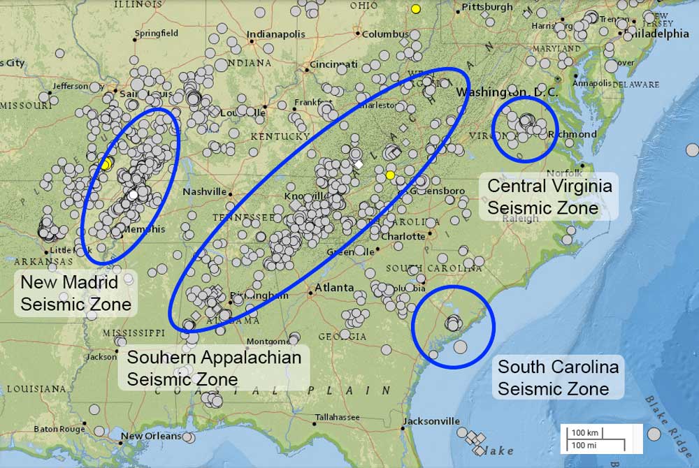
Major seismic zones of the southeastern United States, showing the epicenters of all earthquakes of 2.5 or greater magnitude from the period of January 1, 1980 to November 24, 2021. Map created for the Earth@Home project using the USGS Earthquake Catalog (public domain).
New Madrid Seismic Zone
The New Madrid Seismic Zone (NMSZ, also called the New Madrid Fault Line or Fault System) is a 240-kilometer (150-mile) set of subsurface faults thought to have formed during the breakup of the supercontinent Rodinia in the late Precambrian (about 750 million years ago). Although this rift did not split the continent, it remains an underground weak point—most of the zone's seismicity is located 5–24 kilometers (3–15 miles) beneath the surface. Faults in the NMSZ are occasionally reactivated by the relatively small east-west compressive forces associated with continuing continental drift of the North American plate, making the area unusually prone to earthquakes.
The NMSZ has been the source of numerous earthquakes in western Kentucky, Tennessee, and Mississippi. Four of the largest earthquakes in North American history—the New Madrid Sequence—occurred in the NMSZ on three days over a period of three months: December 16, 1811, January 23, 1812, and February 7, 1812. The quakes, with estimated magnitudes between 7.0 and 8.0, occurred along the Mississippi River in southeastern Missouri and northern Arkansas. While much of the damage was confined to Missouri and Arkansas, the tremors shook the Mississippi Valley and much of the eastern United States, destroying buildings and warping the ground. In Kentucky and Tennessee, landslides occurred along the Mississippi River bluffs and ground subsidence brought on by soil liquefaction spread across the Mississippi River floodplain. Shaking was felt as far away as New Orleans and Boston, where it is said to have caused church bells to ring, and the waters of the Mississippi River appeared to flow backward for several days due to local uplift and waves flowing upstream. Hundreds of aftershocks followed over a period of a several years, and were felt regularly until 1817.
South Carolina Seismic Zone
The South Carolina Seismic Zone is located in the mid-coast area of South Carolina, and is believed to be caused by faults formed during the break-up of Pangea, beginning around 200 million years ago. These faults are very difficult to study, however, because they are buried beneath as much as three kilometers (two miles) of sediment. The South Carolina Seismic Zone was the site of the 1886 Charleston earthquake, which had an estimated magnitude of 7.3 and was the most damaging earthquake to occur in the Southeastern states. The quake damaged and destroyed hundreds of buildings, killed at least 60 people, destroyed kilometers (miles) of railroad tracks, and generated extensive craters and fissures for 1300 kilometers (810 miles) surrounding the epicenter.
"Quake risk in the Southeast" by CNN (YouTube).
The image below shows the intensities felt in surrounding areas after the 1886 earthquake in Charleston, South Carolina.
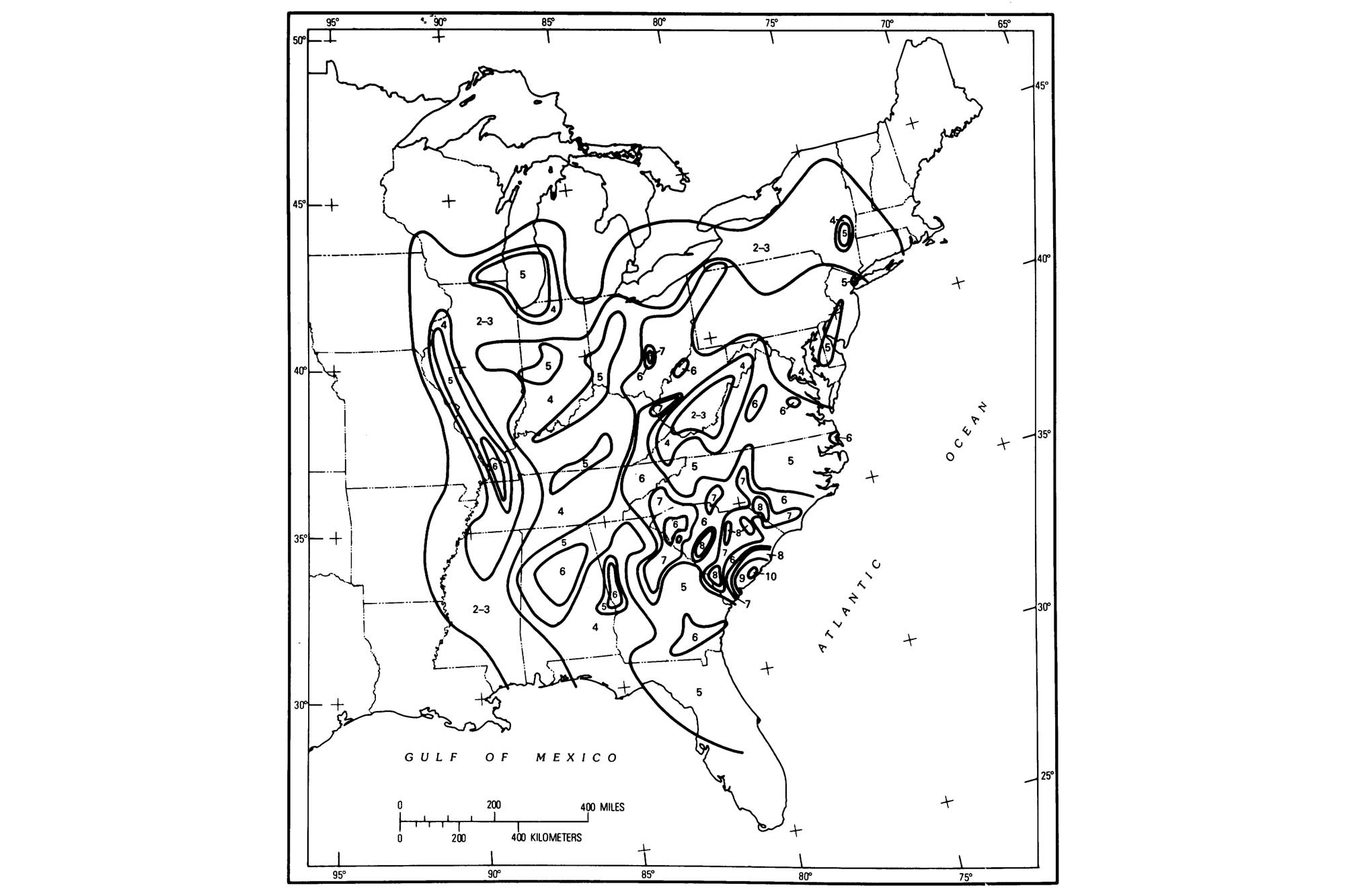
Intensity map of the 1886 Charleston earthquake. Image from USGS/Nuttli etal. (1986) (public domain).
Southern Appalachian Seismic Zone
The Southern Appalachian Seismic Zone (and its extension, the Eastern Tennessee Seismic Zone) runs along the Appalachian Mountains, from easternmost Tennessee to northeastern Alabama. The faults in this zone formed as a result of continental collisions that created the Appalachian Mountains in the mid- to late Paleozoic.
Central Virginia Seismic Zone
The Central Virginia Seismic Zone is located in central Virginia, and has been a site of earthquakes at least since the 1700s. This zone is also a result of the continental collisions that created the Appalachian Mountains; its faults have been reactivated as a result of subsequent rifting and continental movement. Most recently, the Virginia earthquake of August 2011 (M5.8) occurred along a north- or northeast-striking fault in the Piedmont of Louisa County, 61 kilometers (38 miles) northwest of Richmond. No deaths and only minor injuries were reported, but minor damage to buildings was widespread and included the National Cathedral and Washington Monument in Washington, DC. The 2011 earthquake, along with a magnitude 5.8 quake on the New York-Ontario border in 1944, is the largest to have occurred in the US east of the Rocky Mountains since an 1897 temblor centered in western Virginia (M5.9). Research following the 2011 Virginia quake revealed that the farthest landslide from the epicenter was 240 kilometers (150 miles) away, by far the greatest landslide distance recorded from any other earthquake of similar magnitude (previous studies of worldwide earthquakes indicated that landslides occurred no farther than 58 kilometers [36 miles] from the epicenter of a magnitude 5.8 quake). It remains unclear exactly why this occurred.
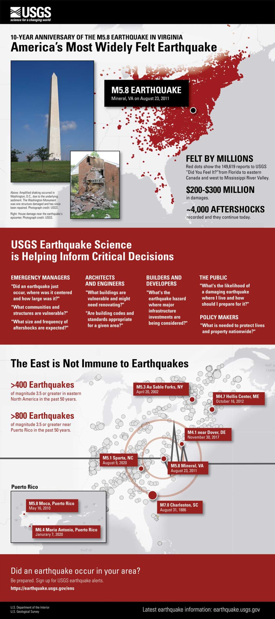
Infographic about the 2011 Virginia earthquake. Image by USGS (public domain).
Vulnerabilities and detection
In the Southeast, the Coastal Plain region (including the Mississippi Embayment, the Gulf Coastal Plain, and the Atlantic Coastal Plain) is considered the most vulnerable since many sizable cities in those areas have been built upon unconsolidated earth materials susceptible to liquefaction, a process by which water-saturated, unconsolidated sediment temporarily loses strength and behaves as a fluid when vibrated. This phenomenon is similar to that observed when you wiggle your toes in the wet sand near the water at a beach. Liquefaction brought on by an earthquake is capable of causing structures to collapse due to loss of support.
Networks of seismograph stations have improved geologists' ability to detect and accurately locate earthquake hazards, and specific fault zones are being studied throughout the Southeast. This information on earthquake risk can lead to better designs for high-risk infrastructure like dams, high-rise buildings, and power plants—and it can also be used to inform the public of potential hazards to lives and property. The hazards associated with earthquakes are mainly related to collapsing buildings and other structures, fire related to broken gas lines and other utilities (and broken water lines preventing firefighting), and in some instances tsunamis—seismic sea waves. Tsunamis are not known to occur along the coastal areas of the Southeast—they tend to be more common along active plate boundaries.
Landslides
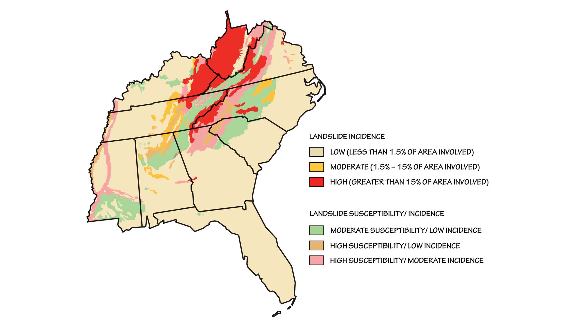
Landslide incidence and risk in the southeastern United States. Modified original map made by the USGS (public domain).
Landslides can also occur in areas with low relief, as with the mass movement of sediments in the Mississippi River drainage basin. Heavy rain, snowmelt, groundwater percolation, and water level changes along coastlines, earthen dams, and the banks of water bodies are conditions under which landslides can occur. These flood-related conditions are associated with precipitation, runoff, and saturation of the ground. Human activity can also lead to mass wasting events, especially where excavation, blasting, or construction occur on unstable or steep surfaces. For example, in March 2015 a massive landslide occurred along the steep edge of fill below the runway of Yeager Airport in Charleston, West Virginia.
"Yeager Airport landslide forces evacuations" by Charleston Gazette-Mail (YouTube).
The airport was built on seven million cubic meters (nine million cubic yards) of engineered fill, due to the lack of suitable flat land for an airport. The landslide occurred after a spell of warm, wet weather following a freeze; it destroyed a church and damaged several homes, caused flooding, and blocked Keystone Road.
In September 2005, heavy rainfall from two consecutive hurricanes dislodged a deadly debris flow from the top of Fishhawk Mountain in Franklin, North Carolina. In only 30 minutes, the flow of debris cleared a 150–300-meter-wide (500–1000-foot-wide) swath of trees, rock, and dirt as it traveled 4 kilometers (2.5 miles) down Peeks Creek at roughly 50 kilometers per hour (30 miles per hour), destroying a housing community and killing four people in a matter of seconds.
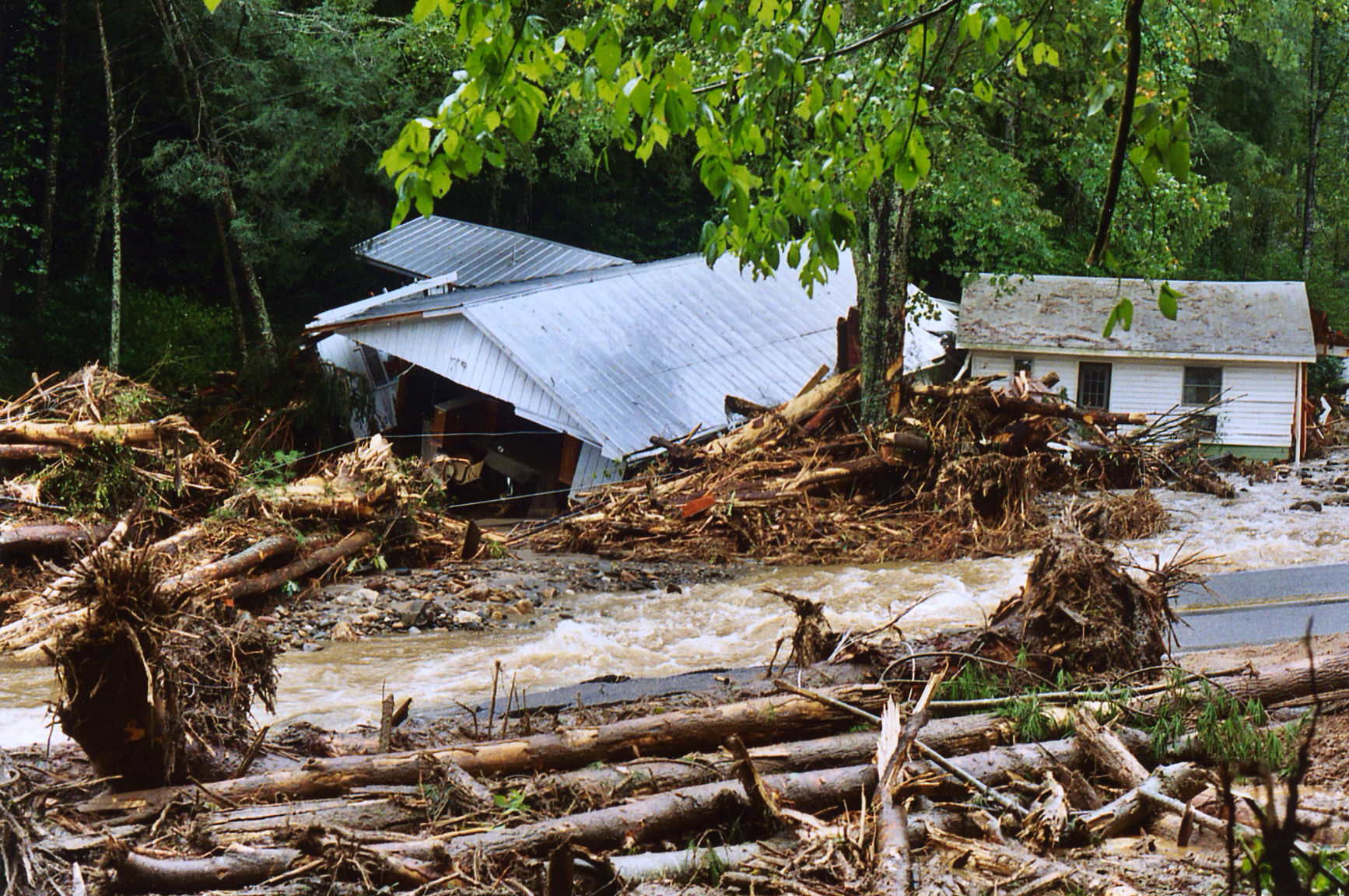
A pile of trees, debris, and homes detached from their foundations after the Peeks Creek landslide in Franklin, North Carolina. Photograph by Don Twardowski (Wikimedia Commons; public domain).
In the Blue Ridge, where the bedrock contains many discontinuities (folded bedding planes, faults, joints, and cleavage) resulting from several episodes of mountain building (the Taconic, Acadian, and Alleghanian orogenies), rock slides and rockfalls are common, especially along transportation routes running east to west through the mountains. US Route 64 in Tennessee and I-40 where it crosses the Tennessee-North Carolina border are often impacted by rockfalls, leading to frequent road closures. Often, stretches of highway remain closed for periods of several months.
"CAUGHT ON CAMERA: Rock Slide Closes TN Highway 64 in Polk Co" by WDEF News 12 (YouTube).
In some low-lying areas of the Coastal Plain, especially southern Mississippi, saturated soils and heavy rains can combine to cause soil liquefaction, which can result in laterally moving mudslides. This can be triggered by storm runoff or by rapid earth movement during an earthquake. Earthquakes along the New Madrid Seismic Zone commonly contribute to landslide incidence along the Mississippi River Valley in Tennessee and Kentucky.
Slumps and creep are common problems in parts of the Southeast with a wetter climate and/or the presence of unstable slopes or unconsolidated sand, especially in the Coastal Plain and the foothills of the Appalachians. Many areas in the Southeast contain expansive soils generated from clay-rich shales. Certain clay minerals can absorb water and swell up to twice their original volume. The pressures exerted through expansion of the minerals in the soil can easily exceed 22 metric tons per square meter (5 tons per square foot)—a force capable of causing significant damage to highways and buildings. An estimated $9 billion of damage to infrastructure built on expansive clays occurs each year in the United States, making swelling soils one of the costliest hazards. In addition, when the clay dries and contracts, the particles settle slightly in the downhill direction. This process can cause soil creep, a slow movement of land that causes fences and telephone poles to lean downhill, while trees adjust by bending uphill.
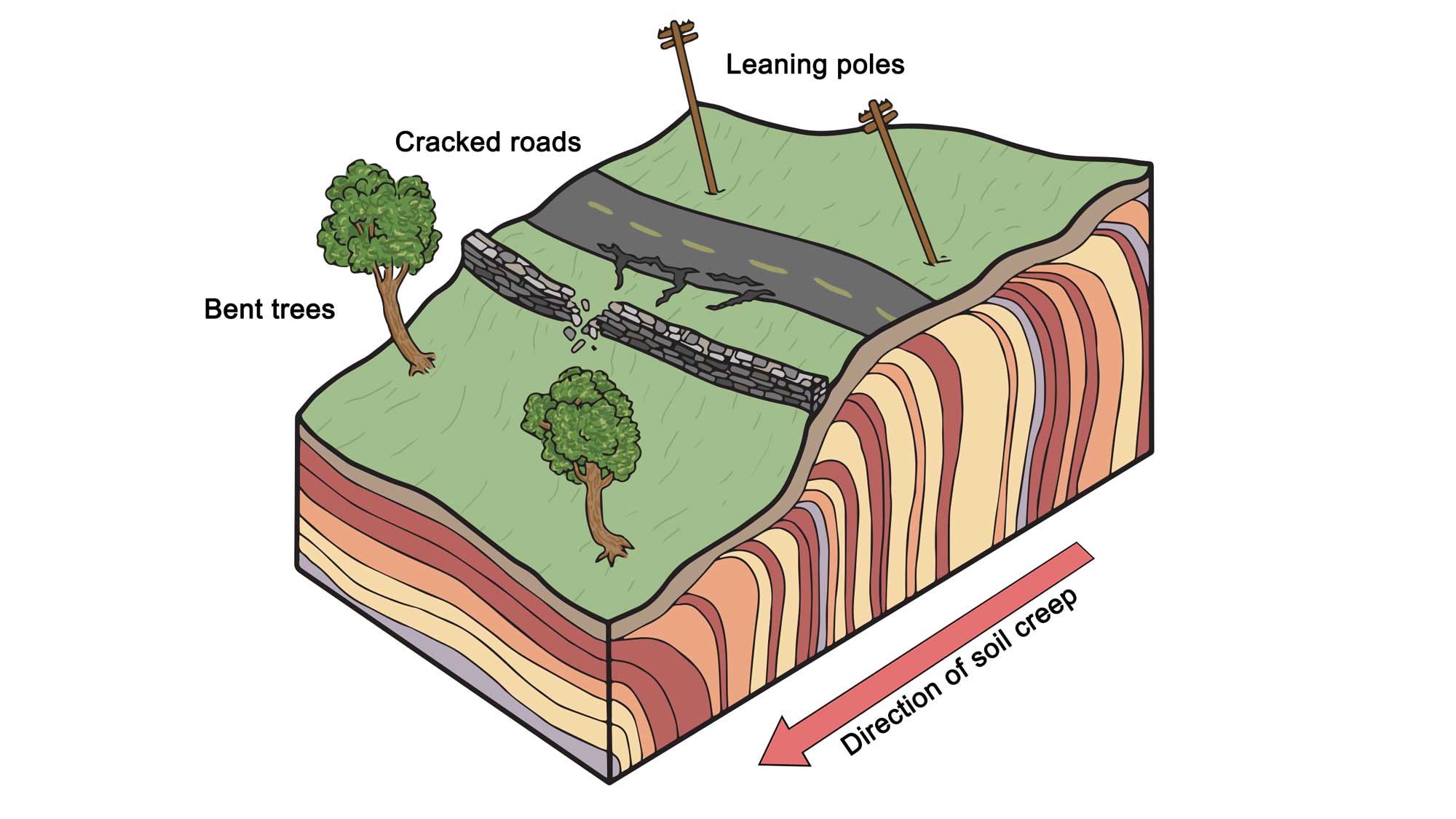
Some of the effects of soil creep on surface topography and structures. Note that subsurface colored layers are meant to depict movement, not stratigraphic layering of soil. Modifed from original by Wade Greenberg-Grand for the Earth@Home project.
Human development can exacerbate this process when homes are built along river bluffs, disturbing vegetation that would otherwise stabilize the slope and adding water to the land in the form of yard irrigation or septic systems.
Expansive soils can be found all over the U.S., and nearly every state in the Southeast has bedrock units or soil layers that are possible sources.
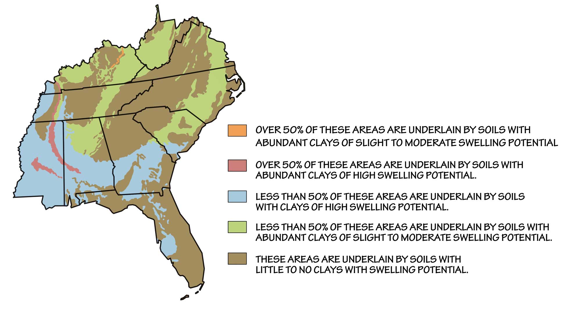
Approximate distribution of expansive soils in the southeastern United States. This map is based on the distribution of types of bedrock, which are the origin of soils produced in place. (Where substantial fractions of the soil have been transported by wind, water, or ice, the map will not be as accurate.) Image by Wade Greenberg-Brand adapted from original by USGS.
"How Soil Destroys Buildings" by Practical Engineering (YouTube).
Clay minerals that expand and contract when hydrated and dehydrated due to their layered molecular structure are generically referred to as smectite; soils that tend to form deep cracks during drought are often indicative of the presence of smectite. The Coastal Plain region has the highest risk of damage caused by swelling soils (clay), but the residual soils of some Paleozoic carbonate rocks may contain smectite, and some Paleozoic pyritic shale formations in the Valley and Ridge can form expansive minerals.
Significant or repeated changes in moisture, which can occur in concert with other geologic hazards such as earthquakes, floods, or landslides, greatly increase the hazard potential of expansive soils. The key to reducing this hazard is to keep the water content of the soil constant. There are also chemical stabilizers, including lime, potassium, and ionic agents, that can reduce the potential for soil volume changes by increasing the clay's structural stability.
Karst and sinkholes
Many parts of the Southeast are underlain by karst and carbonates. Karst areas, which are often connected to the natural groundwater circulation system, can also be subject to flooding when sinkholes are plugged with refuse or covered over by parking lots, driveways, or buildings.
Central and southern Kentucky, including most of the Interior Basin, is one of the most famous karst areas in the world. About 55% of the state is underlain by limestones and dolostones that are capable of developing karst, and 25% of the state already has well-developed karst features. This is evident in the large number of commercialized caverns advertised throughout the state, including Mammoth Cave National Park.
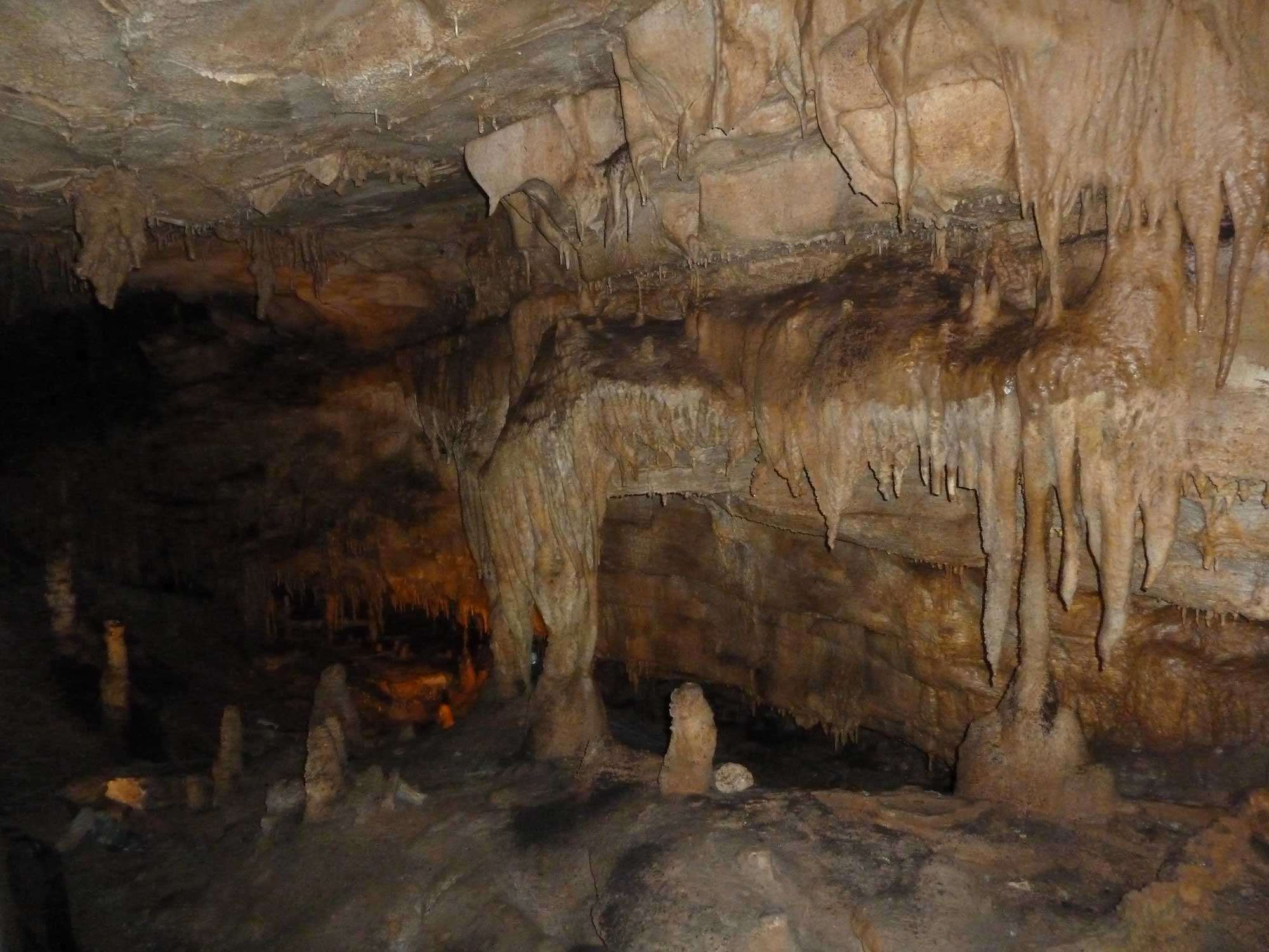
Mammoth cave in Kentucky is the longest known cave system in the world, spanning more than 640 kilometers (400 miles) of vast chambers and complex labyrinths in karstic rock.
In Tennessee and northern Alabama, especially the Nashville Basin and Highland Rim, Paleozoic limestones are abundant, with significant karst and related dissolution hazards. Southern Alabama and Mississippi contain karst formations related to the dissolution of subsurface salt, and the entire state of Florida is underlain by karstic limestone.
"Sinkhole in Florida 2013: Family Captures Escape From Sinkhole Resort on Video" by ABC News (YouTube).
Sinkhole formation commonly damages roads, buildings, and utilities, and it is a major environmental problem in the Southeast, including Kentucky, Tennessee, Alabama, and especially Florida, which has numerous lakes that were formed by sinkholes.
In 2014, a sinkhole in Bowling Green, Kentucky received worldwide media coverage when it opened beneath the Corvette Museum, swallowing eight collectable sports cars.
"Top Stories of 2014: Sinkhole Opens Up At Corvette Museum in Bowling Green" by NewsChannel 5 (YouTube).
Radon
The granitic basement rocks of the Blue Ridge and Piedmont (formed during the Grenville Orogeny) and the metasedimentary rocks that form the present Appalachian Mountains (derived from the ancient Grenville Mountains) are the greatest sources of radon in the Southeast. Areas in the Interior Lowlands with Devonian-Mississippian black shale bedrock are also subject to high levels of risk.
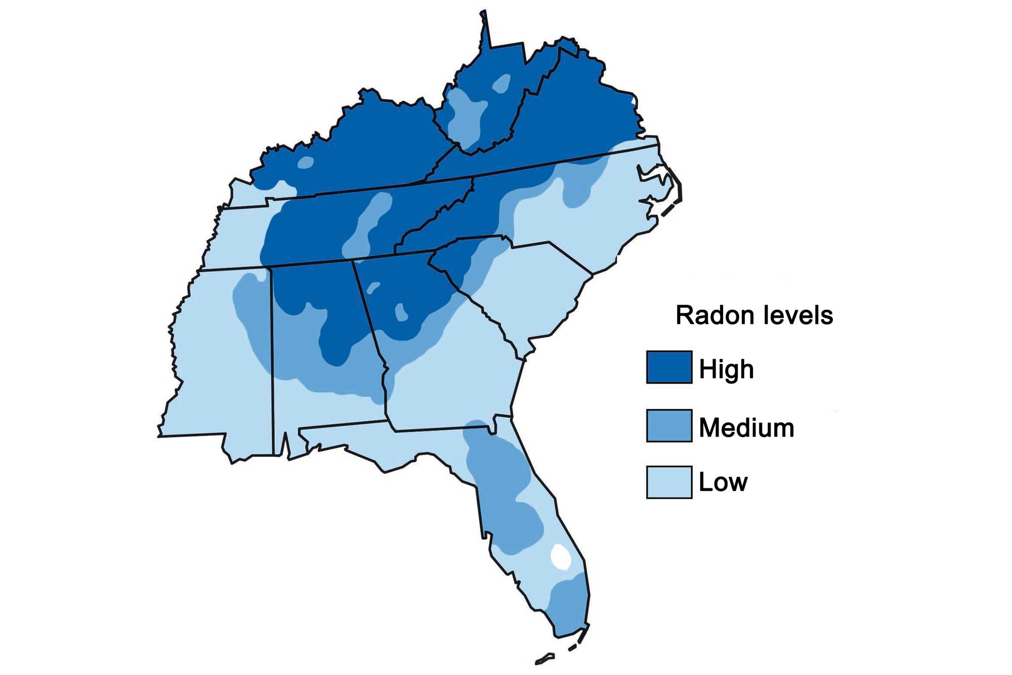
Radon risk levels at the surface in the southeastern United States. Image by Wade Greenberg-Brand, adapted from original by the Environmental Protection Agency.
Floods
Torrential rains in May of 2010 resulted in "thousand-year floods"—an event thought to occur only once every thousand years— along the Cumberland River in Tennessee, Kentucky, and Mississippi. As much as 480 millimeters (19 inches) of rain fell over a two-day period; in Nashville, the river reached a height of 16 meters (52 feet), and 31 people were killed throughout the flood zone.
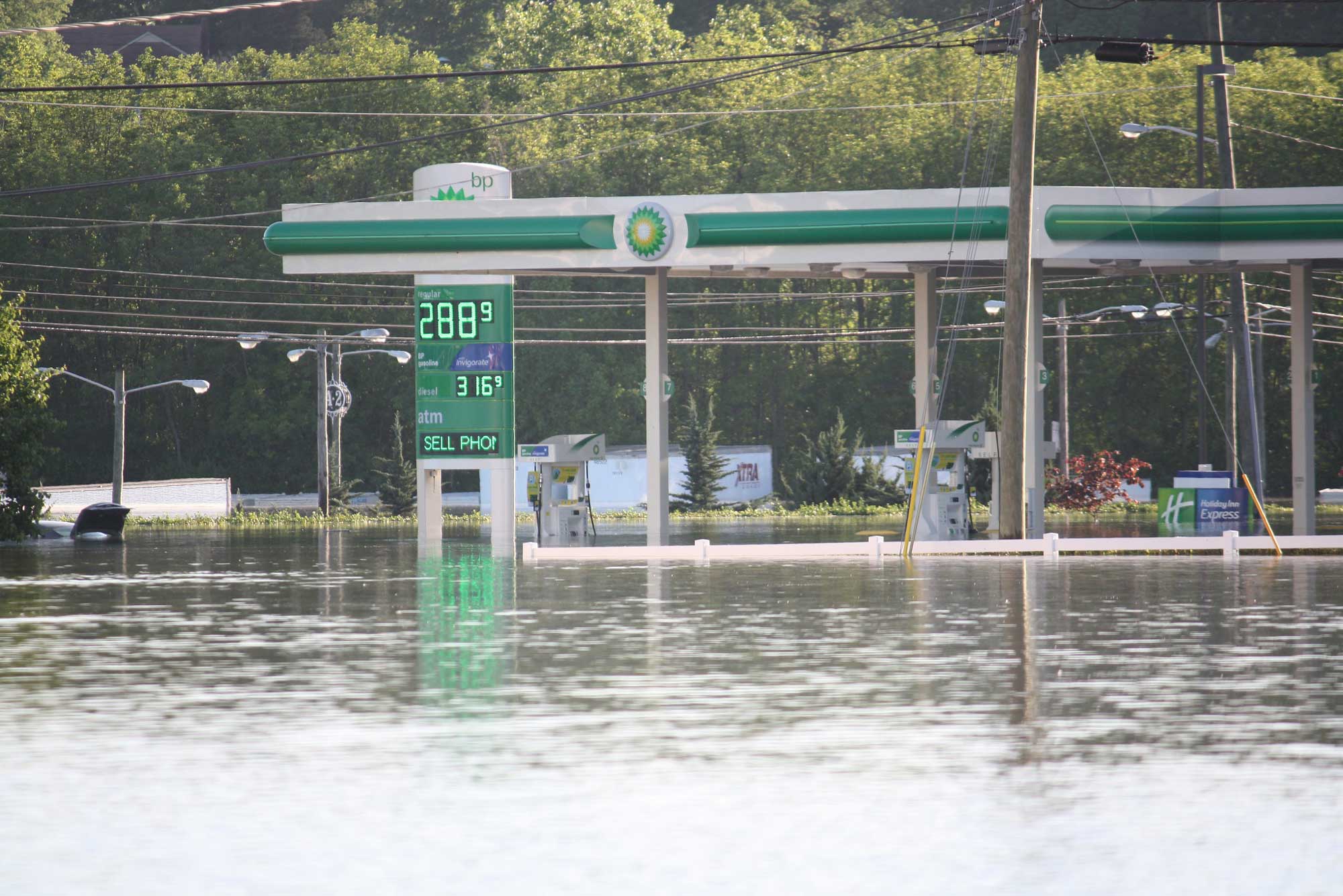
A flooded gas station in Nashville, Tennessee; photograph taken by "Jay" on May 3, 2010 (Flickr; Creative Commons Attribution 2.0 Generic license).
Major floods in the Southeast often occur along the Mississippi River and its tributaries.
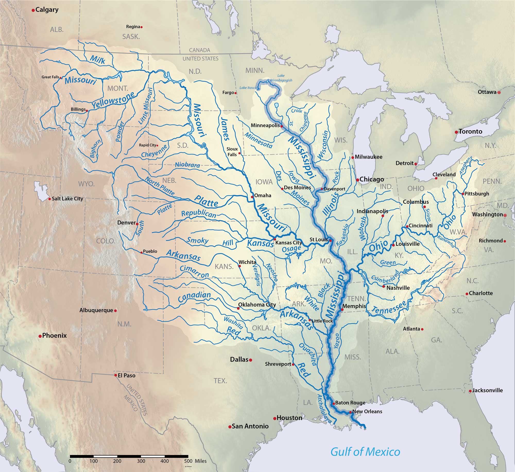
The Mississippi River and its tributaries. Image by "Shannon1" (Wikimedia Commons; Creative Commons Attribution-ShareAlike 4.0 International license; image resized from original).
The 1927 Mississippi Flood was the greatest flood on the lower Mississippi River in modern history. From the summer of 1926 until the spring of 1927, heavy rains fell in eastern Kansas, Oklahoma, and the Ohio Valley. Between February and April 1927, numerous levees broke along the Mississippi River from Illinois to Louisiana, inundating numerous towns in the Mississippi Valley. The break at Mounds Landing near Greenville, Mississippi was the single greatest levee rupture to ever occur along the Mississippi River. It flooded an area 80 kilometers (50 miles) wide and 160 kilometers (100 miles) long with up to 6 meters (20 feet) of water. Heavy spring rains caused a second major flood that June. In all, 73,500 square kilometers (28,400 square miles)—home to more than 931,000 people—were inundated.
The Mississippi River floods in April and May 2011 were also among the largest and most damaging along this US waterway in the past century, rivaling major floods in 1927 and 1993.
In April 2011, two major storm systems dumped record rainfall on the Mississippi River watershed. Areas along the Mississippi from Illinois and Iowa to Mississippi and Louisiana experienced heavy flooding.
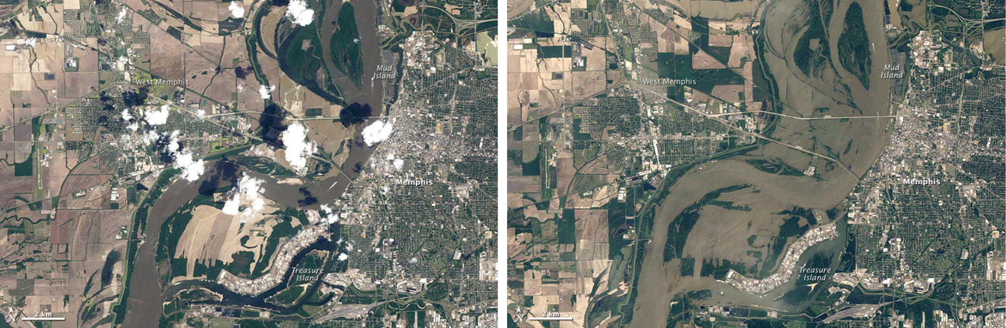
The region surrounding Memphis, Tennessee before (left) and after (right) the flooding of May 2011. On May 10, the Mississippi River reached 14.59 meters (47.87 feet) above normal level. This was the highest water level in the city since 1937. Image by NASA Earth Observatory (public domain).
The Southeast's Coastal Plain is topographically low and flat and contains numerous rivers, and is therefore more prone to flooding—from a variety of sources—than many other areas of higher elevation farther inland. Major flooding can be caused by high rainfall, which can swell rivers, and by major coastal storms, especially tropical storms and hurricanes. The catastrophic floods that struck South Carolina in October 2015 were caused by extraordinary rainfall from an easterly moving storm, combined with Hurricane Joaquin, which struck the Atlantic coast. The first week of October saw one of the most prolific rainfall events in the modern US history: five-day totals exceeded 500 millimeters (20 inches) in many places in South Carolina.
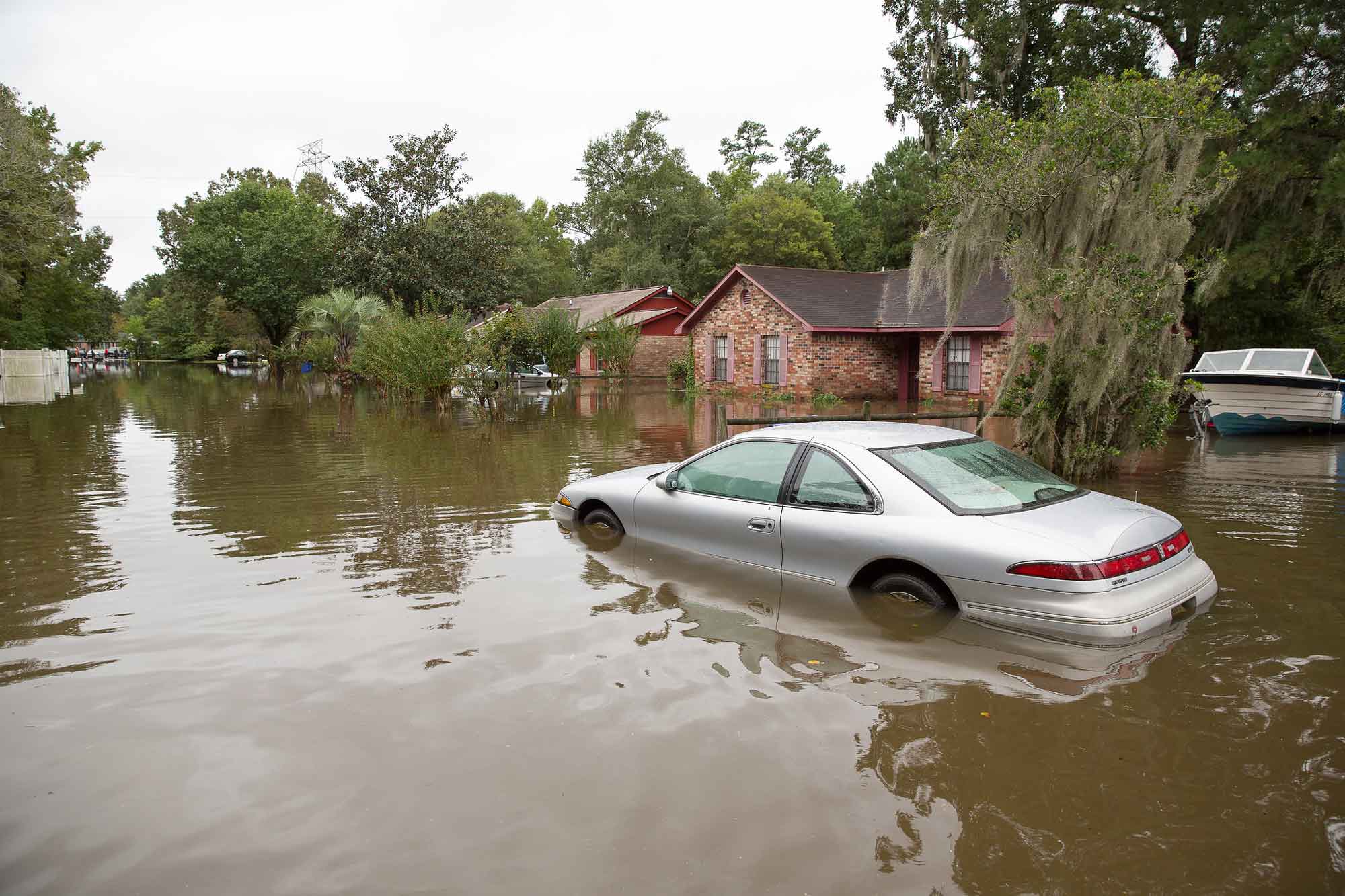
Flooding in North Charleston, South Carolina resulting from Hurricane Joaquin in October 2011. Photograph by Ryan Johnson (Flickr; Creative Commons Attribution-ShareAlike 2.0 Generic license).
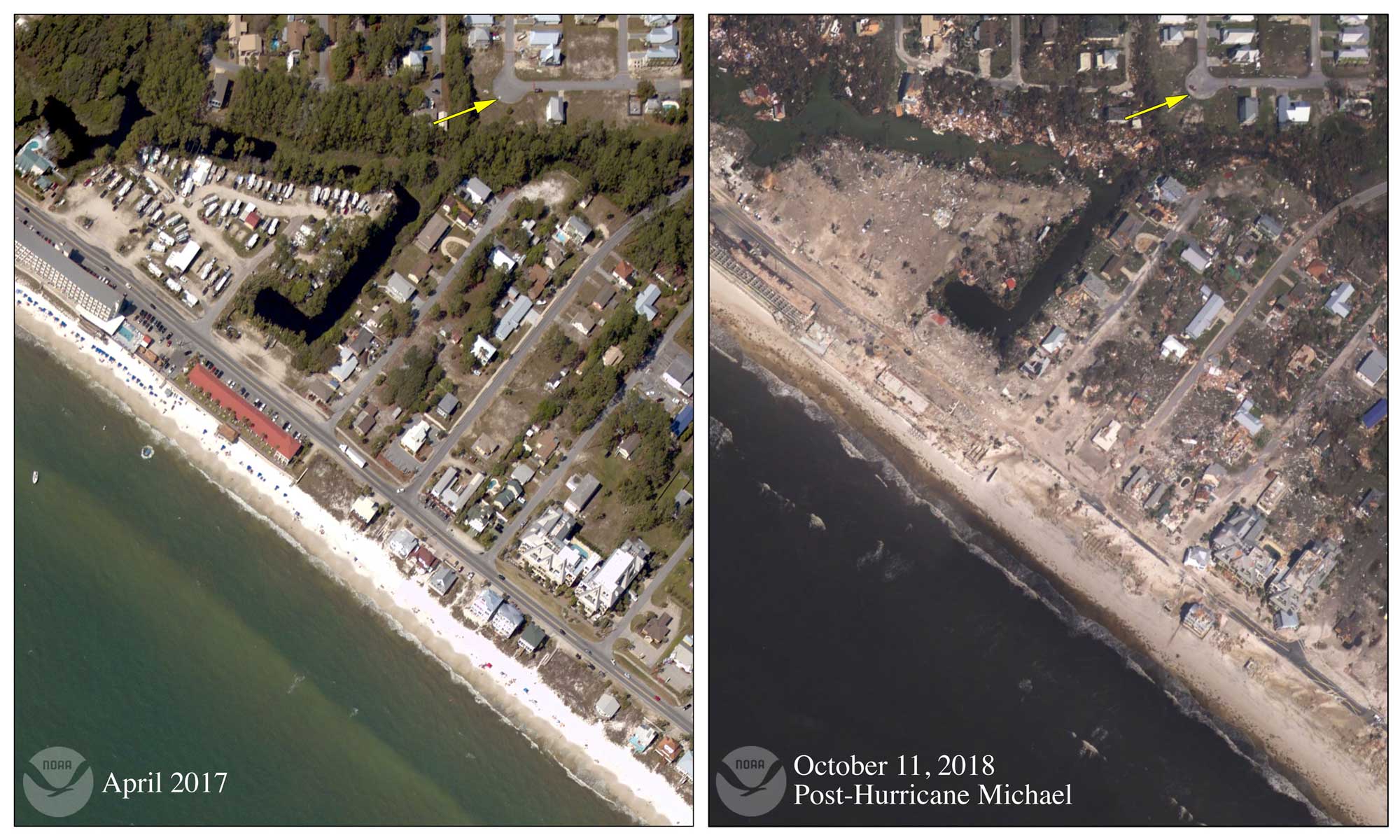
Damage in Mexico Beach, Florida resulting from Hurricane Michael's storm surge on October 10, 2018. Hurricane Michael made landfall as a category 5 hurricane. Image by NOAA (Wikimedia Commons; public domain).
While floods are always considered a hazard to life and property, they present a compound threat when they trigger mudslides or contribute to the conditions that cause expansive soils and karst topography. While there is no way to completely avoid the destructive impacts of flooding, good community planning and informed decision-making can greatly reduce the safety concerns and economic impacts of these events. Flood control is part of the mission statements of many government agencies, including the National Resource Conservation Service (NRCS), US Corps of Engineers (USCE), Tennessee Valley Authority (TVA), and US Geological Survey (USGS). These agencies and others maintain gauges on most large rivers and streams in the Southeast from which flow data are gathered.
Sea level rise, coastal erosion, and subsidence
The total linear coastline of the Southeastern US measures 4094 kilometers (2544 miles); out of 23 states with coasts, Florida is ranked second in terms of coastal area, North Carolina is seventh, South Carolina is eleventh, and Virginia, Georgia, Alabama, and Mississippi are ranked fifteenth through nineteenth, respectively. Property losses from coastal hazards are extremely high and are likely to increase as shorelines become more developed and sea levels continue to rise.
The coastal areas of the Southeastern US are typically sandy beaches with dunes. Many of these beaches are barrier islands built of sand. Longshore currents cause constant shifting of the sand found on these barrier islands by eroding it in one location and depositing it in another.
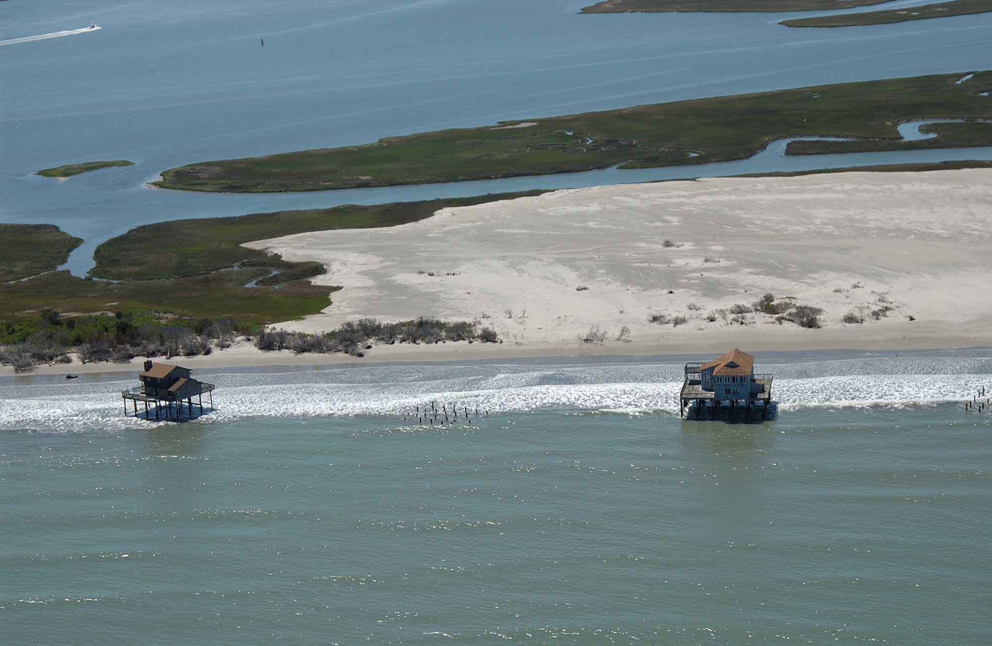
These houses on Cedar Island, a barrier island off Virginia's coastline, were originally built on solid ground. As sand on the island migrated, the buildings were left behind. Image by USGS (public domain).
At present, erosion seems to be more dominant than deposition as sea level slowly rises. In just the last 25 years, for example, more than 480 hectares (1200 acres) have been eroded from the barrier islands in South Carolina's Cape Romain National Wildlife Refuge. So much sand has been removed from many beaches in the Southeast that sand is often borrowed from other sites in order to make the beaches suitable for recreation and to prevent buildings from being eroded away.
The Coastal Plain is threatened by the triple risk of coastal erosion, sea level rise, and subsidence, with subsidence exacerbating the effects of the first two. Subsidence is the local sinking of land, involving little or no horizontal motion. It is induced through either the natural or anthropogenic removal of underlying support. Subsidence in the Southeast is common due to the abundance of soluble carbonate rocks (limestone and dolostone) and the area's warm, humid climate.
Compaction of sediment, extraction of water and minerals from the soil, and collapse along fault lines are combining to increase the rate of subsidence. A combination of coastal erosion, sea level rise, subsidence, and increased storm intensity could have catastrophic impacts on the Coastal Plain region.
The Everglades is a vast wetland system in southern Florida, extending from Lake Okeechobee and its tributary areas, to the southern tip of the Florida peninsula at Florida Bay. Since 1900 much of the Everglades has been drained for agriculture and urban development; today only about 50% of the original wetlands remain. This draining, and the related oxidation of peat deposits, has caused extensive land subsidence, which has contributed to a local rise in sea level. Combined with the intensive exploitation of the major freshwater aquifers beneath the Everglades, this has increased salinity in the normally fresh-to-brackish surface waters of the Everglades and Florida Bay. This trend will only continue as sea level rises due to ongoing climate change.
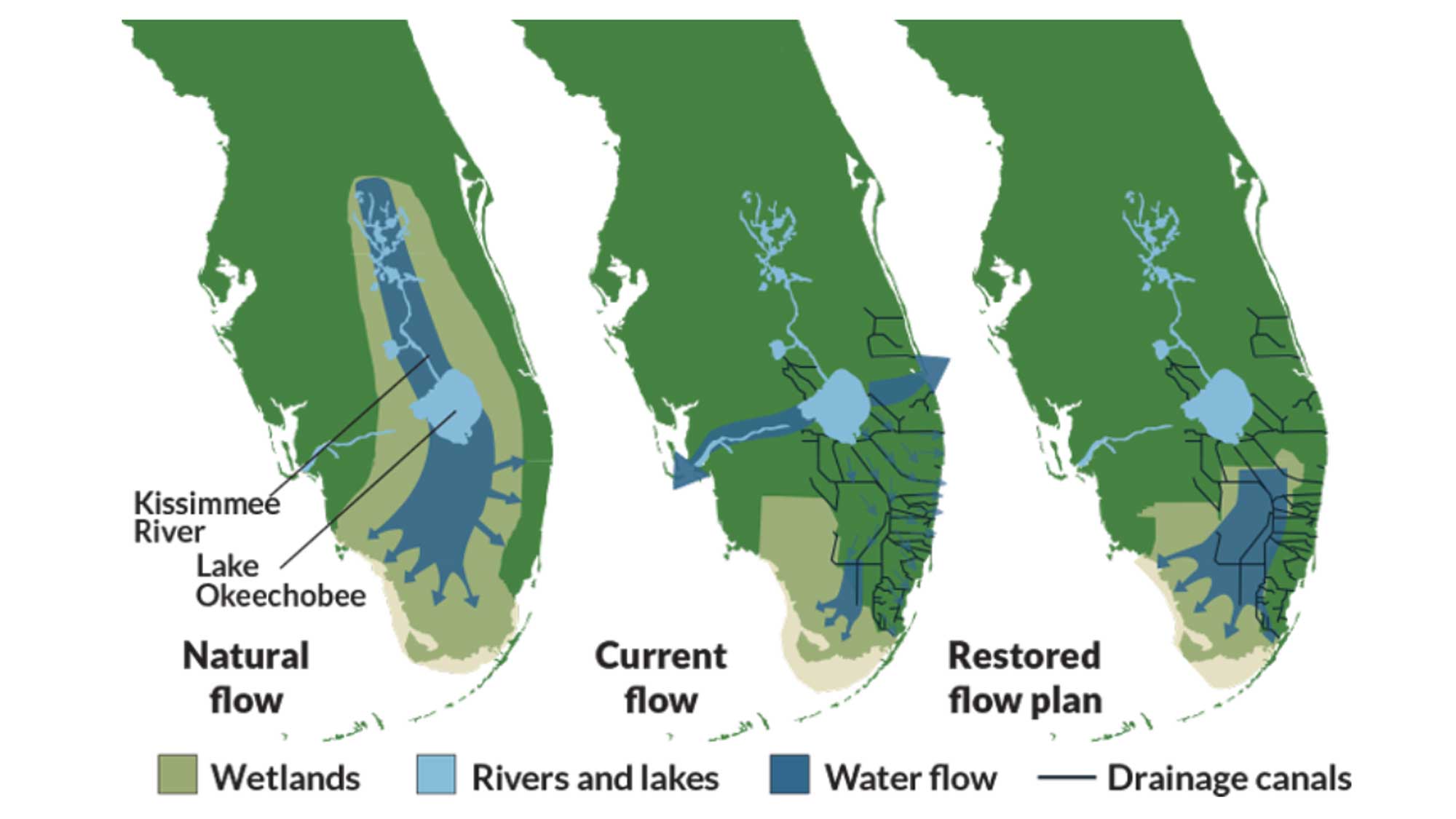
Changes in drainage flow from the Everglades as a result of human activity over the past 200 years, including proposed future flow plans. Image by the U.S. Army Corps of Engineers (public domain).
Weather hazards
The Southeast is an extremely active location for high-energy atmospheric events such as tornados and hurricanes. It also experiences a variety of other weather hazards, including high temperatures and drought. In 2013, the National Oceanic and Atmospheric Administration (NOAA) reported that since 1980, the Southeast had experienced more billion-dollar weather disasters than any other part of the United States.
Storms, tornados, and derechos
Rainstorms occur where colder air from higher latitudes abruptly meets warmer air. This often happens in the mid-latitudes, including the Southeastern US, where air may warm up as it passes over flat open spaces or when warm, moist air is delivered off the Gulf of Mexico.
Flat regions, such as the Coastal Plain, allow winds to move unimpeded by topography, and are often subject to severe thunderstorms. While severe thunderstorms are common in some parts of the Southeast, two less common storm hazards have the potential to cause serious property damage and endanger lives: derechos and tornados. Both of these storm events are associated with wind shear, which occurs when the wind's speed or direction changes with increasing height in the atmosphere.
Approximately one derecho every year or two will occur in Mississippi, Alabama, northwest Georgia, Tennessee, Kentucky, and West Virginia, with fewer along the Gulf and Atlantic coastlines.
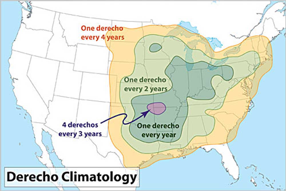
Derecho frequency in the continental United States. Map by NOAA (public domain).
"Dixie Alley" is the nickname for an area, extending from Louisiana and Arkansas east to Georgia, which is known for its large number of strong tornados associated with flat topography and severe thunderstorms.
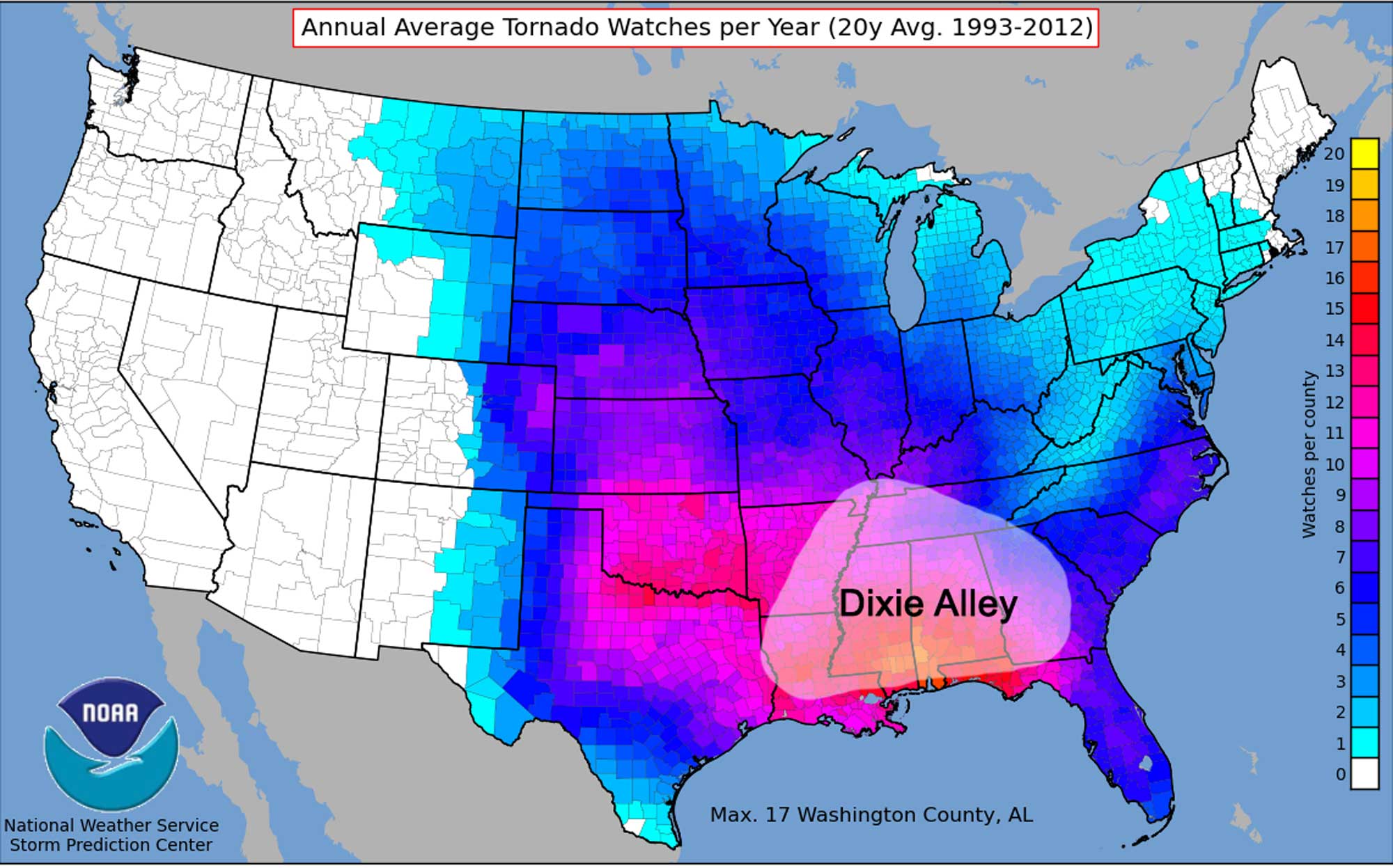
Twenty-year average yearly tornado watches in each county of the United States between 1993 and 2012. Dixie Alley is identified. Map by NOAA (public domain) modified for the Earth@Home project.
The boundaries of Dixie Alley may vary in application, depending on whether the frequency, intensity, or number of events per location are used to determine the area's borders. In the Southeast it encompasses Mississippi, Alabama, Georgia, and parts of Tennessee, reflecting more tornados in these states. From 1991 to 2010, for example, an annual average of 44, 43, 33, and 26 tornados occurred in Alabama, Mississippi, Georgia, and Tennessee, respectively. To the east and north of Dixie Alley, fewer tornado strikes occur, with an annual average of 31 in North Carolina, 27 in South Carolina, 21 in Kentucky, 18 in Virginia, and 2 in West Virginia. While Florida is not typically considered part of Dixie Alley, it is also subject to numerous tornados thanks to a constant influx of warm, moist air; the state experiences an annual average of about 66 tornados. Florida is also commonly subject to waterspouts, which often form when a tornado's cyclic winds travel over water.
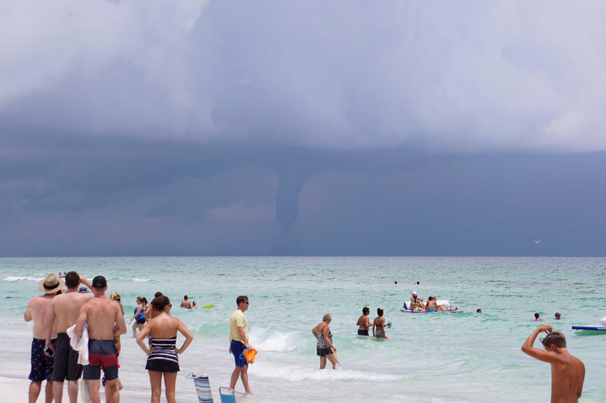
A waterspout over the ocean near Pensacola Beach, Florida in 2016. Photograph by Steve Harwood (Flickr; Creative Commons Attribution-NonCommercial 2.0 Generic license).
Waterspouts can also form in association with convection beneath large cumulus clouds; these are the most common kind, with over 400 typically seen annually in Florida.
The Southeast does not have a specific tornado season, though they tend to occur more frequently in February to April. Among large recent tornado events was the "2008 Super Tuesday tornado outbreak" (February 5–6, 2008). In total 87 tornados were confirmed, many in Tennessee and Kentucky, and 5 of them rated EF4; 57 people were killed across four states, and damage was estimated at half a billion dollars. An even larger event—one of the largest ever recorded—was the "2011 Super Outbreak" (April 25–28, 2011). It involved 355 confirmed tornados, 11 of which were EF4 and 4 of which received the maximum rating, EF5. Across six states, 324 people died, and the event caused $11 billion in damage. The outbreak most impacted Alabama and Mississippi, but also affected Arkansas, Georgia, Tennessee, and Virginia.
On December 10, 2021 an outbreak of tornadoes in the midwestern and southeastern United States caused significant damage and 90 people lost their lives. One tornado in particular reached EF4 intensity and stayed on the ground for over 165 miles and about 3 hours. It destroyed much of the city of Mayfield, Kentucky.
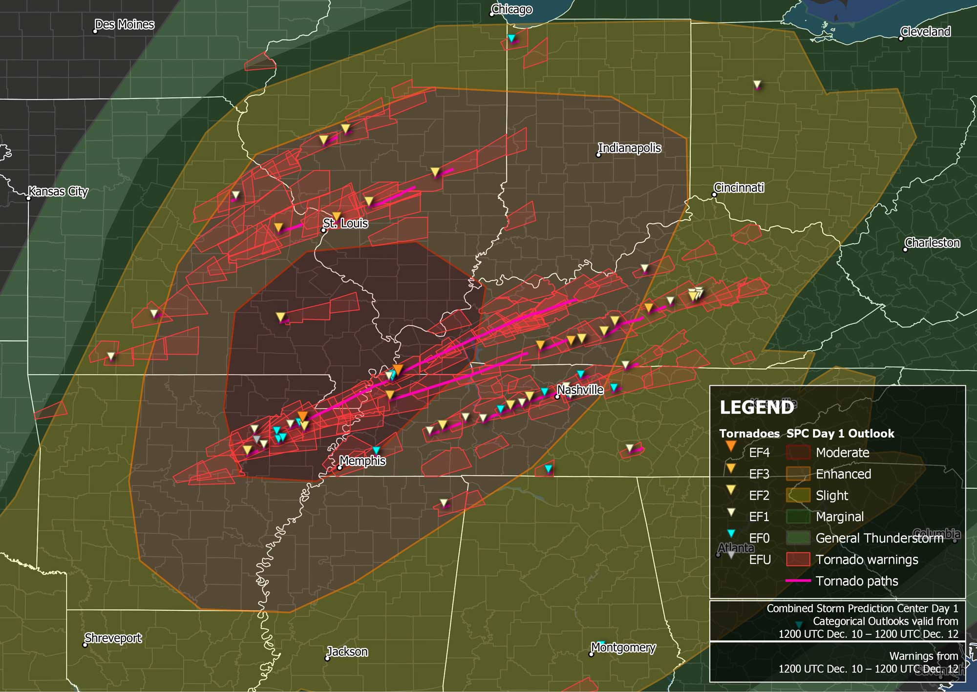
Locations and intensities of tornadoes in the December 10, 2021 outbreak. Image by "TheAustinMan" (Wikimedia Commons; Creative Commons Attribution-ShareAlike 4.0 International license).
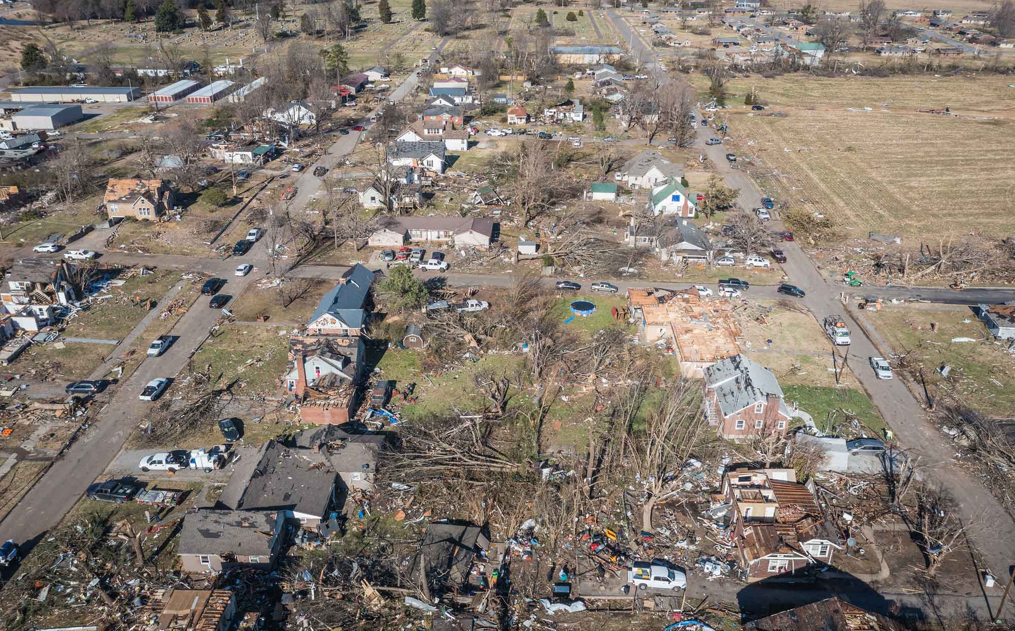
An EF4 tornado caused significant damage to the city of Mayfield, Kentucky. Photograph by State Farm (Flickr; Creative Commons Attribution 2.0 Generic license).
"12-11-2021 Mayfield, Ky Catastrophic Tornado damage- First light drone" by Live Storms Media (YouTube).
Hurricanes
In an average year, about a dozen hurricanes travel through the western Atlantic and sometimes the Gulf of Mexico. Of these, roughly two a year strike the Atlantic coast. About 40% of all hurricanes to strike the U.S. hit Florida and since 1851, 36 of them have been major hurricanes (Category 3 or above). The peak month is September, followed by August and October. More rarely, hurricanes may hit the coast in June, July, or November. The 2005 hurricane season was the most active in recorded history, with a record number of 15 hurricanes, 7 of which strengthened into major hurricanes.
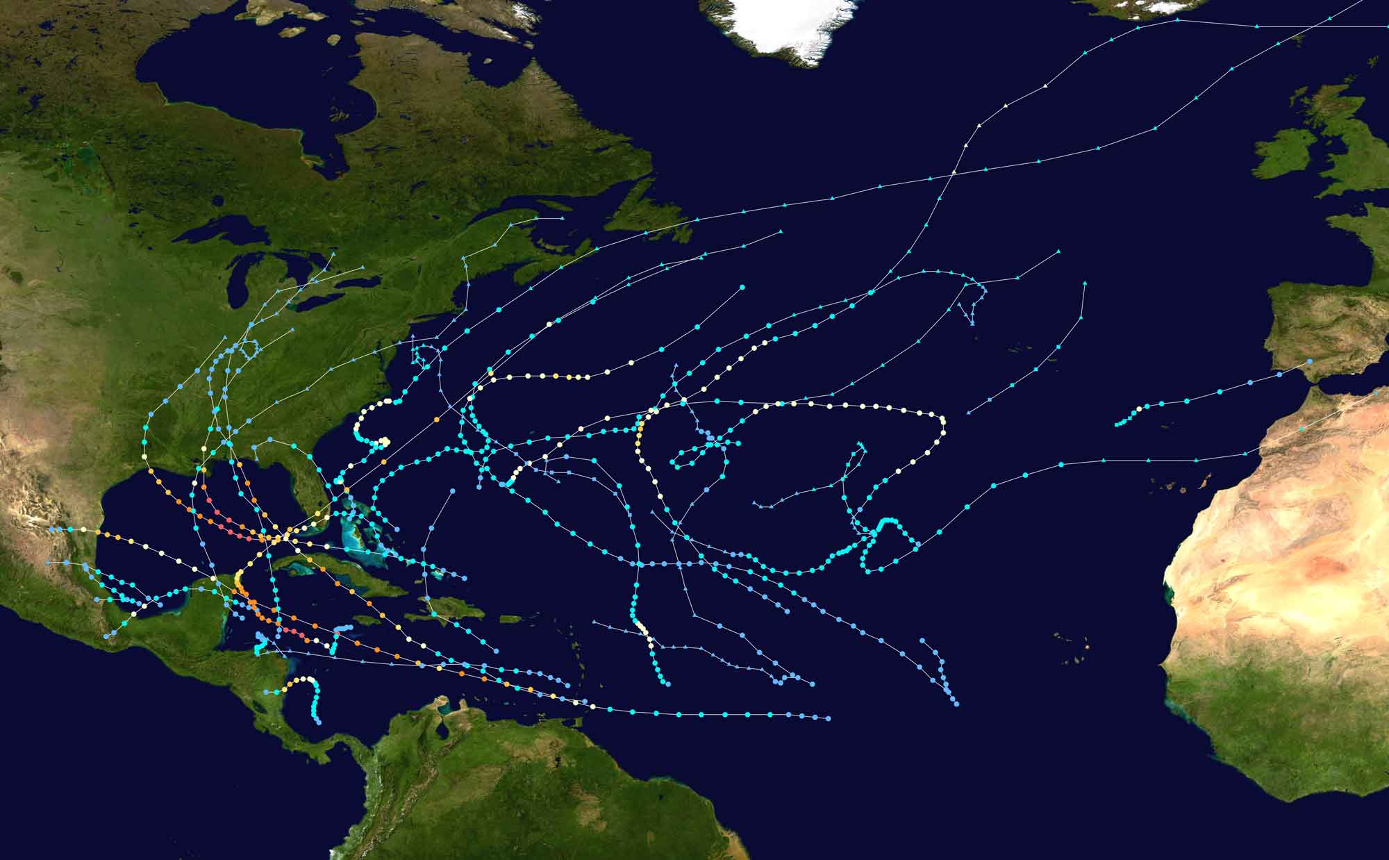
Tracks of all Atlantic hurricanes during the 2005 season. Warmer colors indicate higher maximum sustained wind speeds. Image by "Supportstorm" (Wikimedia Commons; public domain).
The costliest hurricane to date was Katrina in August 2005, with almost 2000 lives lost and over $178 billion (adjusted to 2021 value) in damage. The costliest hurricane in the Southeast was Andrew in 1992, with over $53 billion in damage (2021 value).
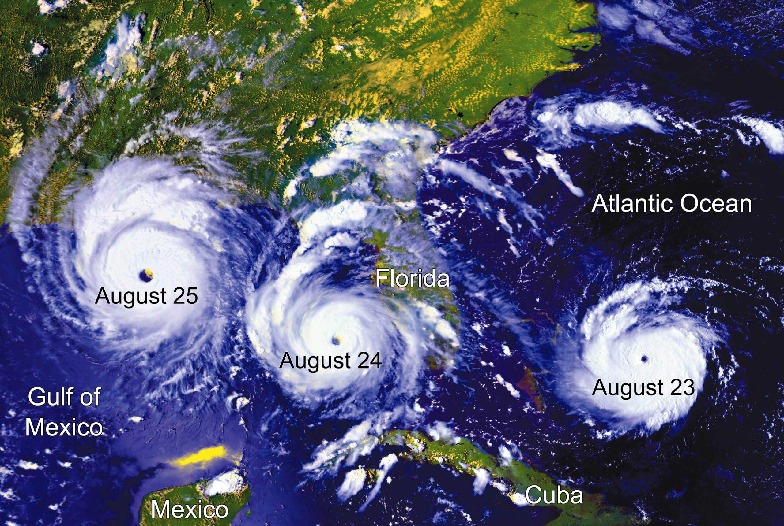
The path of Hurricane Andrew between August 23-25, 1992. Map by NASA, modified for the Earth@Home project.
Although Hurricane Andrew, which was a Category 5 storm, caused only 65 fatalities, it obliterated thousands of homes and buildings across Miami and Homestead, Florida. Once hurricanes reach land, they lose energy rapidly, though they typically continue to deliver substantial precipitation and somewhat high winds for hundreds of kilometers (miles) onshore. Hurricanes that make landfall along the Atlantic coast tend to track northward following the eastern seaboard, while those that track over the Florida Panhandle, Mississippi, and Alabama generally veer north to northeast, heading across Georgia, North and South Carolina, and Tennessee.
Major hurricanes affecting the southeastern United States
| Date | Name and landfall location(s) | Category at landfall | Deaths |
|---|---|---|---|
| August–September 1935 | Labor Day Hurricane; FL | 5 | 600 |
| August 1969 | Hurricane Camille; MS | 5 | 259 |
| August 1992 | Hurricane Andrew; FL, LA | 5 | 65 |
| September 1919 | Florida Keys Hurricane; FL | 4 | 772 |
| September 1926 | Great Miami Hurricane; FL, AL, MS | 4 | 539 |
| September 1928 | Okeechobee Hurricane; FL, SC | 4 | 4079 |
| October 1954 | Hurricane Hazel; NC, SC | 4 | 1191 |
| August 1979 | Hurricane Frederic; AL, MS | 4 | 12 |
| September 1989 | Hurricane Hugo; SC | 4 | 107 |
| August 2004 | Hurricane Charley; FL | 4 | 35 |
| June 1966 | Hurricane Alma; FL | 3 | 91 |
| August–September 1996 | Hurricane Fran; NC | 3 | 27 |
| September 2004 | Hurricane Ivan; AL | 3 | 124 |
| July 2005 | Hurricane Dennis; FL | 3 | 89 |
| August 2005 | Hurricane Katrina; FL, LA | 3 | 2000 |
Extreme temperature and drought
In July 2011, parts of the Southeast experienced the nation's hottest summer heat wave in 75 years, with temperatures reaching upward of 55°C (131°F) during a period of four months.
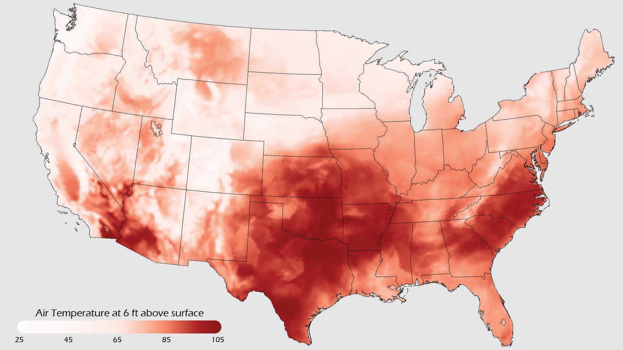
Air temperature in the continental United States during July 2011. Image by NOAA (public domain).
Although Texas, Oklahoma, and Arkansas took the brunt of the extreme heat, the Carolinas, Georgia, and Mississippi also experienced severe temperatures. The heat wave contributed to severe drought, amplified heat-based health emergencies, and caused a heavy spike in electricity usage (related to increased air conditioning use) that generated a record-breaking demand on the power grid and led to increased energy prices.
While high temperatures can be directly dangerous, a larger scale hazard arises when these temperatures are coupled with lack of precipitation in an extended drought period. Several significant droughts have occurred in the Southeastern states; the most severe droughts in Kentucky and Virginia occurred from 1930 to 1932, and intense drought struck much of the Southeast, especially Georgia and South Carolina, during the heat wave of 2011. In 2012, more than 25% of the state of Georgia was in a period of exceptional drought, the most intense level possible. Additionally, in October 2015, some parts of Mississippi experienced "extreme drought," the fourth of five drought levels recognized by NOAA's U.S. Drought Monitor.
Climate change
It is important to understand that most of the extreme climate change in Earth's history occurred before humans existed. That being said, the rapid release of carbon dioxide into the atmosphere from human activity is currently causing a global warming event. The seemingly slight increase in the average annual temperatures in the Southeast over the past 25 years has been accompanied by more frequent heat waves, shorter winters, and an increased likelihood of drought and wildfires.
Although wildfires can occur during any season, summer fires are the most common, since increased dryness contributes to fire risk. The Bugaboo Scrub Fire, which raged from April to June 2007, was the largest fire in the history of Florida and Georgia; it consumed 243,000 hectares (600,000 acres) of land and 1738 lives were lost.
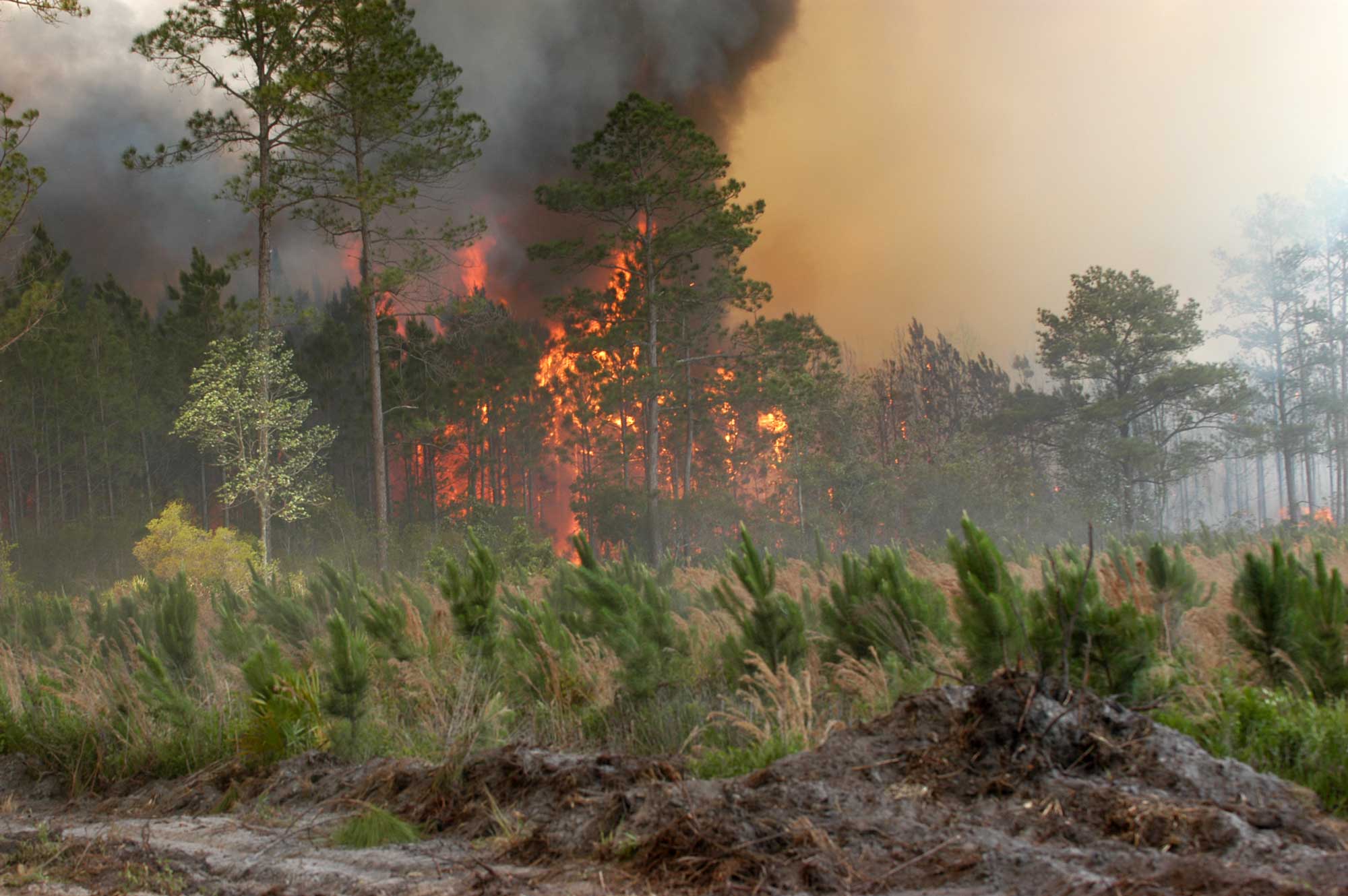
The Bugaboo Scrub Fire burns out of control near Lake City, Florida, in May 2007. Photograph by FEMA (Wikimedia Commons; public domain).
In 2014, one of the worst wildfire years on record, 2436 fires burned across Florida, destroying 41,115 hectares (101,599 acres) of land, while 1249 fires burned 63,289 hectares (156,391 acres) in Tennessee.
Water supply is also a critical issue for the Southeastern states. Large parts of the area obtain agricultural and drinking water from aquifers, underground layers of water-bearing permeable rock. The Floridan Aquifer, one of the world's most productive aquifers, underlies all of Florida as well as parts of South Carolina, Georgia, and Alabama. As drought has intensified and temperature has risen, the amount of water drawn from the aquifer (especially for agricultural irrigation) has increased, while the rate at which the aquifer refills has decreased. In addition, the aquifer is at risk from saltwater intrusion as sea level rises due to warming temperatures.
Increasing temperatures also allow certain pests, such as ticks and mosquitoes, to live longer, thereby increasing the risk of contracting the diseases they carry. In addition, invasive organisms that damage ecosystems, such as the hydrilla plant in Florida and along the Gulf Coast, have a better chance to multiply and outcompete native organisms because increased temperatures stress local ecosystems and create an environment more favorable to invasive species.
Another concern regarding hazards exacerbated by climate change in the Southeast is whether or not there has been or will be an increase in the number or severity of storms, such as hurricanes and tornados. According to NASA, the present data is inconclusive in terms of whether hurricanes are already more severe, but there is a greater than 66% chance that global warming will cause more intense hurricanes in the 21st century. Since climate is a measure of weather averaged over decades, it might take many years to determine that a change has occurred with respect to these types of storms. Scientists are certain that the conditions necessary to form such storms are becoming more favorable due to global warming.