

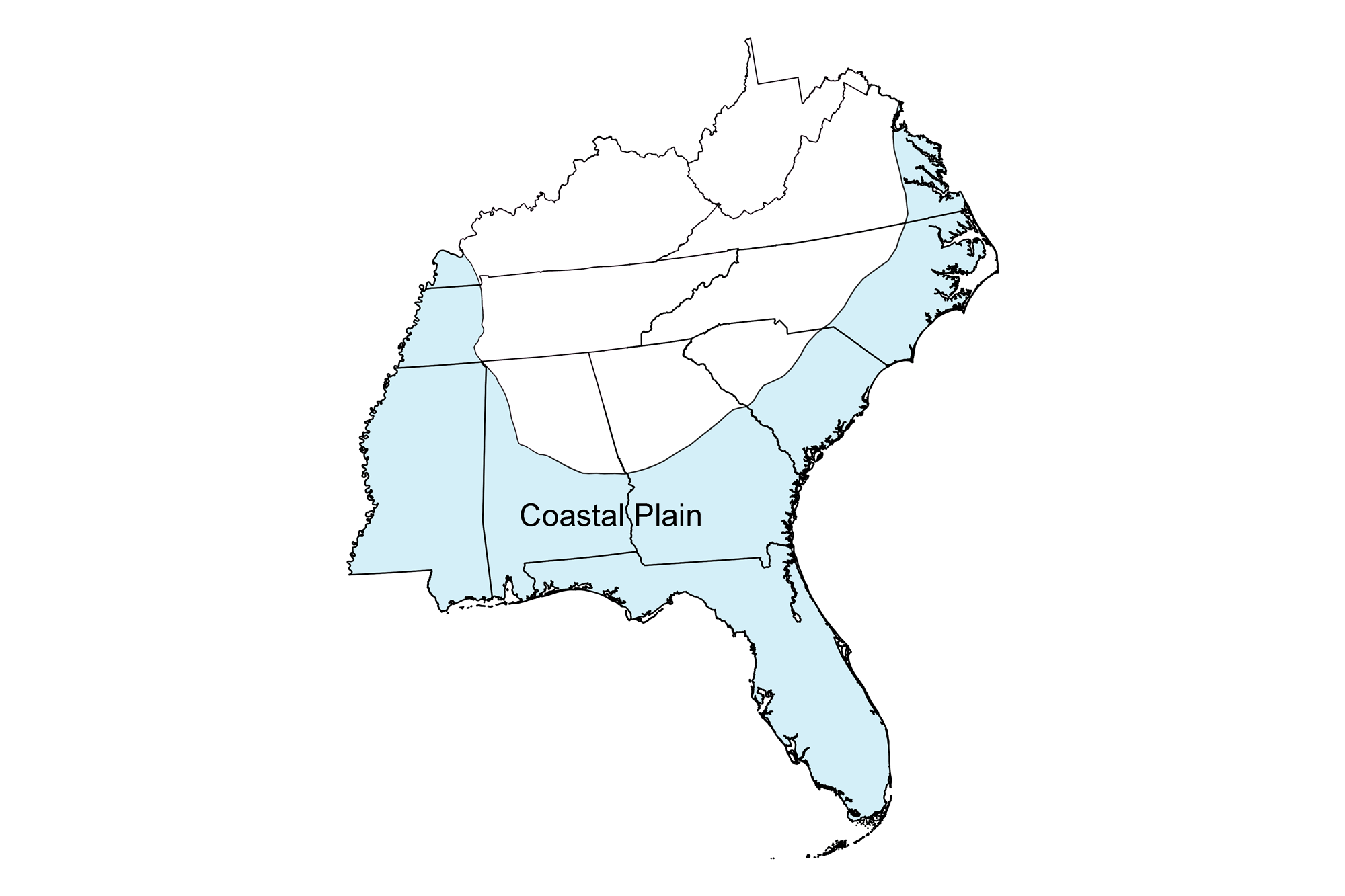
Snapshot: Overview of the major rock types of the Coastal Plain region of the southeastern United States.
Topics covered on this page: Overview; Cretaceous; Paleogene and Neogene; Quaternary; Meteorite impacts; Resources.
Credits: Most of the text of this page is derived from "Rocks of the Southeastern US" by Jane A. Picconi and Charles C. Smith, chapter 2 in The Teacher-Friendly Guide to the Earth Science of the Southeastern U.S., 2nd ed., edited by Andrielle N. Swaby, Mark D. Lucas, and Robert M. Ross (published in 2016 by the Paleontological Research Institution; currently out of print). The book was adapted for the web by Elizabeth J. Hermsen and Jonathan R. Hendricks in 2021–2023. Changes include formatting and revisions to the text and images. Credits for individual images are given in figure captions.
Updates: Page last updated September 20, 2023.
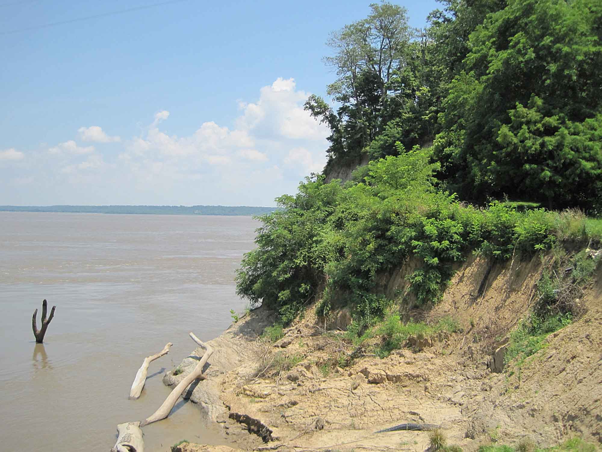
Image above: Fossiliferous unconsolidated layer of early Pleistocene sand in Florida. The fossils are predominantly bivalves. Photograph by Jonathan R. Hendricks.
Overview
After the breakup of Pangaea during the Mesozoic, the North American plate drifted away from the Mid-Atlantic Ridge. Decreased tectonic activity along the continent’s eastern and southeastern edge led to the formation of a passive continental margin. The Coastal Plain extends along this margin, sweeping in a wide arc through Virginia, around the point of Florida, and up through the Mississippi Embayment and across Texas. The sediment and rock of the Coastal Plain is geologically very young, ranging in age from the Cretaceous to the present.
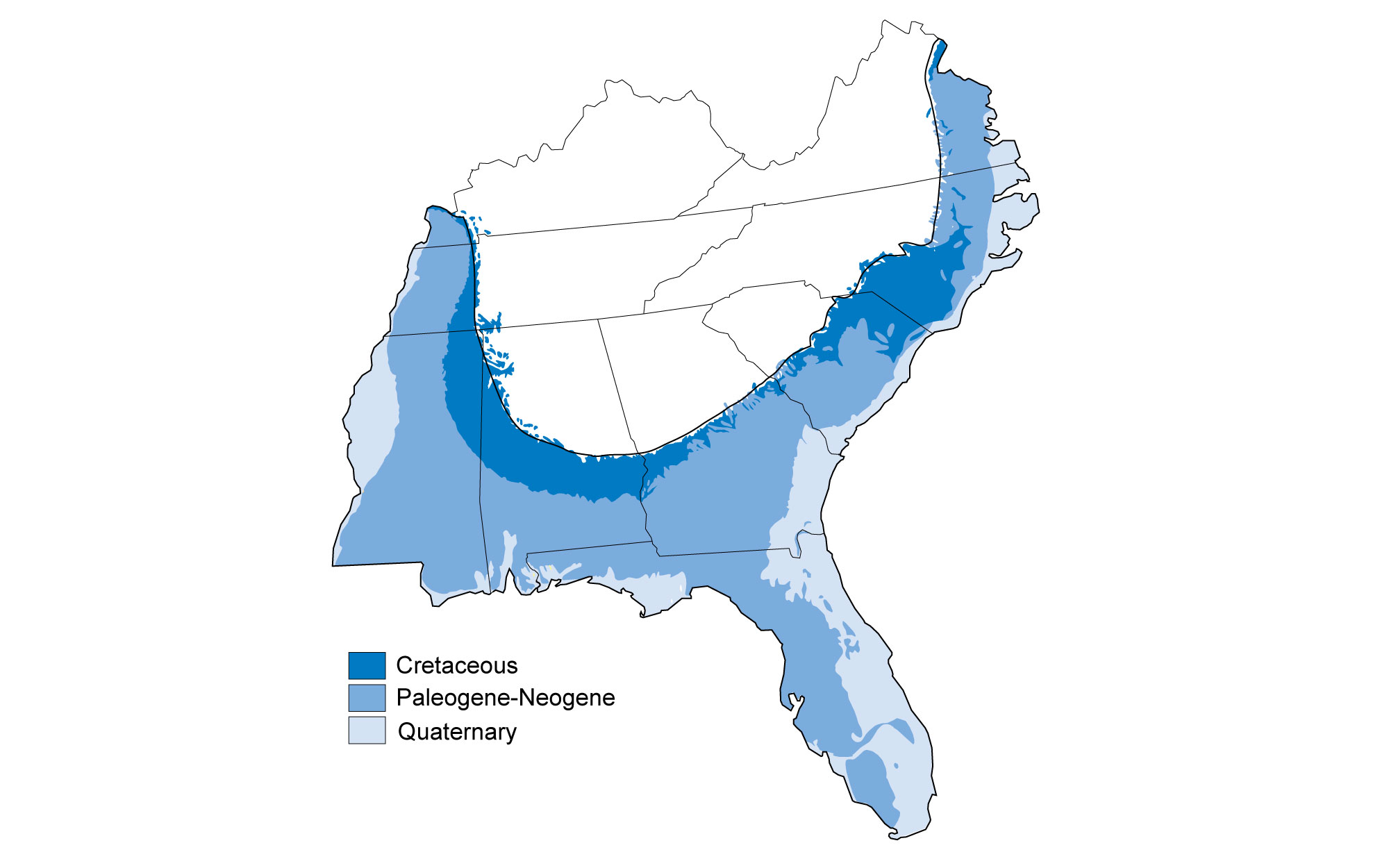
A generalized geologic map of the Coastal Plain.
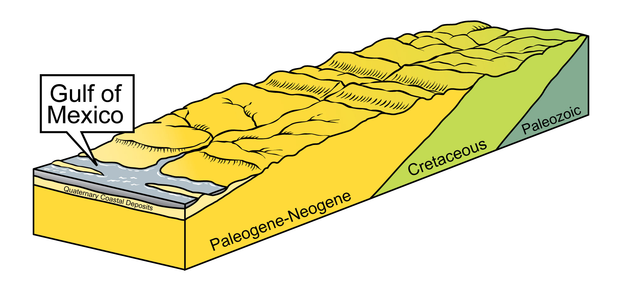
The Coastal Plain's sediment and rock includes gravel, sand, silt, clay, marl, limestone, and uncommon layers of concentrated shell material called coquina. Much of the Coastal Plain’s "rock" is actually unconsolidated sediment that has not had enough time to be lithified, cemented, or sufficiently compacted into hard rock. Coastal Plain sediment forms a wedge of gently dipping layers of sediment and sedimentary rock that thickens toward the Gulf of Mexico, overlying older bedrock.
Millions of years of sediment accumulation in the Gulf of Mexico and Atlantic Ocean caused coastal areas to subside, creating a gentle slope toward the ocean.
As the Atlantic Ocean and Gulf of Mexico widened following the breakup of Pangaea, the weight of millions of years of sediment accumulation in the basins caused coastal areas to subside, creating a gentle slope eastward toward the Atlantic and southward toward the Gulf of Mexico. At its innermost edge (bordering the Piedmont), the wedge of sediments is very thin, but under the continental shelf in the Atlantic Ocean, the wedge of sediment is as much as 4000 meters (13,100 feet) thick, and it reaches thicknesses of up to 12 kilometers (7.5 miles) in some places along the Gulf Coast. The Mississippi River Valley also subsided during the Mesozoic and Cenozoic, causing a similar tilting of Coastal Plain sediment toward the Mississippi Embayment. This tilting, although slight, exposes older Cretaceous units that would otherwise be buried by younger sediment.
Cretaceous
The oldest sediment deposits exposed at the surface in the Coastal Plain are found along the region's inner edge and record the erosion of the Appalachian Mountains. As rivers transported sediment to the coast, successive layers of gravel, sand, silt, and clay fanned out onto the continental shelf. A variety of clays are found in the Cretaceous rocks of the Southeast, including kaolinite, a valuable economic resource that is mined in certain areas of the Southeast. Another type of clay, montmorillonite, has been interpreted as weathered volcanic ash that came from central Mississippi or the Rocky Mountains. Volcanic activity associated with the uplift of the Rockies could have generated ash that spread as far as the Southeastern states—but the Southeast has its own volcanic past, attested to by a set of igneous rocks and ash deposits found 900 meters (2900 feet) beneath Jackson, Mississippi. The uplifted terrain from the Jackson Volcano also formed an area of dense rock, the Jackson Dome, which is notable as an oil reservoir. Jackson Volcano and other related structures likely formed as the Gulf of Mexico widened and rifting generated significant volcanic activity. Volcanoes located along the rim of the modern Gulf Coast spewed ash that settled in layers at the surface; far below, the volcanoes' magmatic cores eventually cooled to form intrusive rock. Jackson, Mississippi is unique: no other US state capital or large city is situated on top of an extinct volcano!
Toward the end of the Cretaceous, global sea level was high, allowing the deposition of marine sediment across much of the Coastal Plain. Greensand, a green-colored sandstone that gets its color from the green mineral glauconite was deposited in these marine settings during the Cretaceous, Paleogene, and Neogene. (Since glauconite is associated with modern marine environments, its presence suggests to geologists that this sediment was deposited in the ocean.)
Other clues to the marine origin of late Cretaceous sediment in the Southeast include thick deposits of chalk, a soft variety of limestone that forms from the buildup of microscopic plates (coccoliths) from single-celled algae. Chalk is common in Cretaceous deposits worldwide, and represents deeper ocean waters in which calcareous detritus settled to the bottom and accumulated as layers of calcium carbonate. White chalk deposits are often mixed with gray-green layers of marl, formed when clay particles settle to the bottom and are mixed with the layers of calcium carbonate. In Alabama and Mississippi, thick chalk and marl layers are found in an area known as the Black Belt, named for its nearly black, rich topsoil.
Although there are no Cretaceous rocks exposed at the surface in Florida, the carbonate sediment deposited during this period created the foundation of the modern Florida Platform. Following the breakup of Pangaea, the area that is now Florida gradually sank, allowing reef communities to flourish and build on top of each other while sea level slowly rose. Currents in the Gulf Trough (also called the Suwanee Strait), a channel that separated the Florida Platform from the mainland, swept away sediment eroded from the Appalachian Mountains and protected the corals and other organisms whose calcium carbonate skeletons formed Florida’s modern foundation.
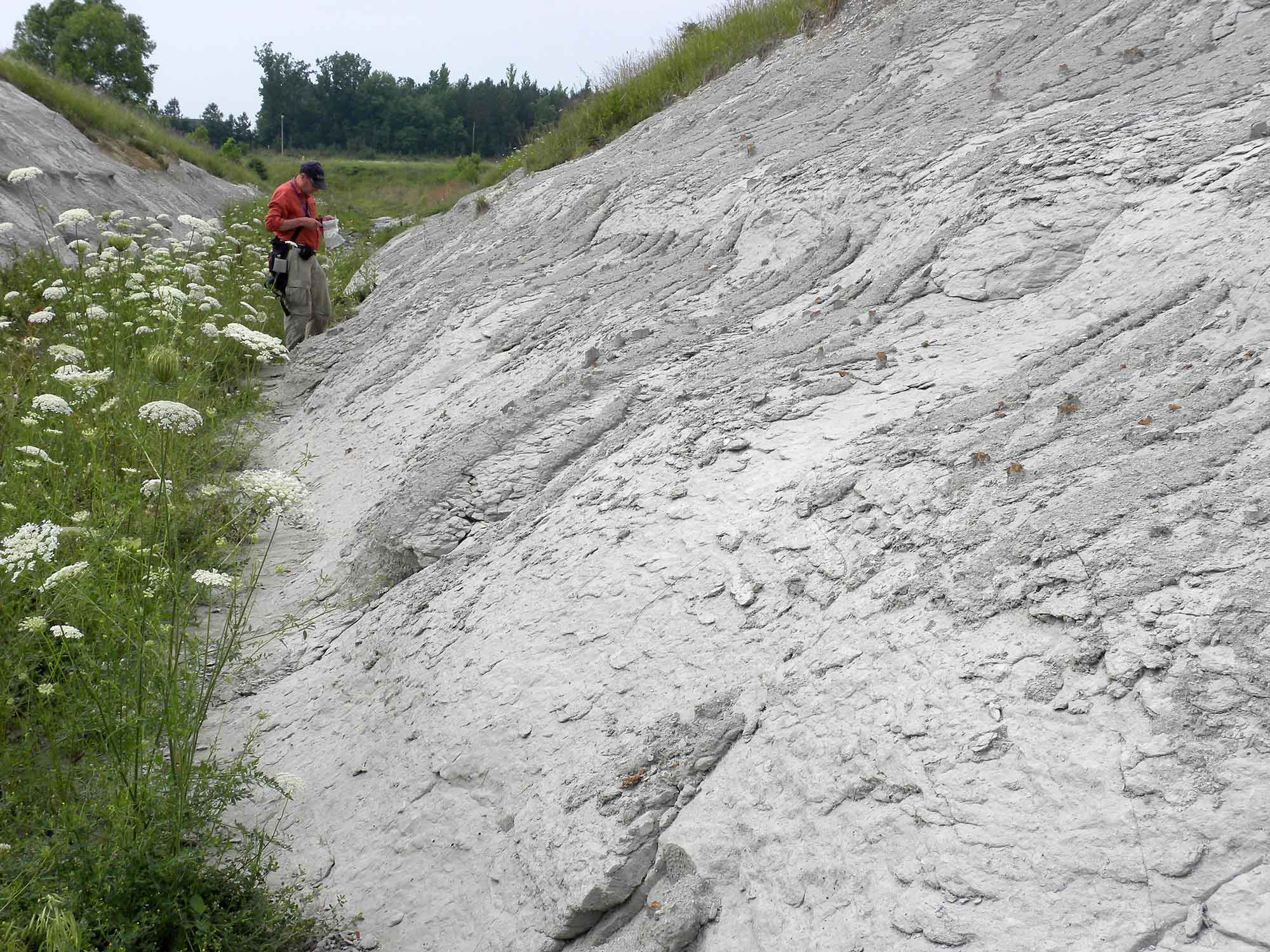
Within the Atlantic and Gulf Coastal Plain, the Cretaceous-Paleogene (K-Pg) boundary is usually distinguished by a change in lithology. Paleogene sands or sandstones and dark gray marls and clays overlie white Cretaceous chalks and clays, and are visible at Moscow Landing along the Tombigbee River in Sumter County, Alabama; along the south valley wall of Lynn Creek in Noxubee County, Mississippi; and in Providence Canyon State Park in Stewart County, Georgia.
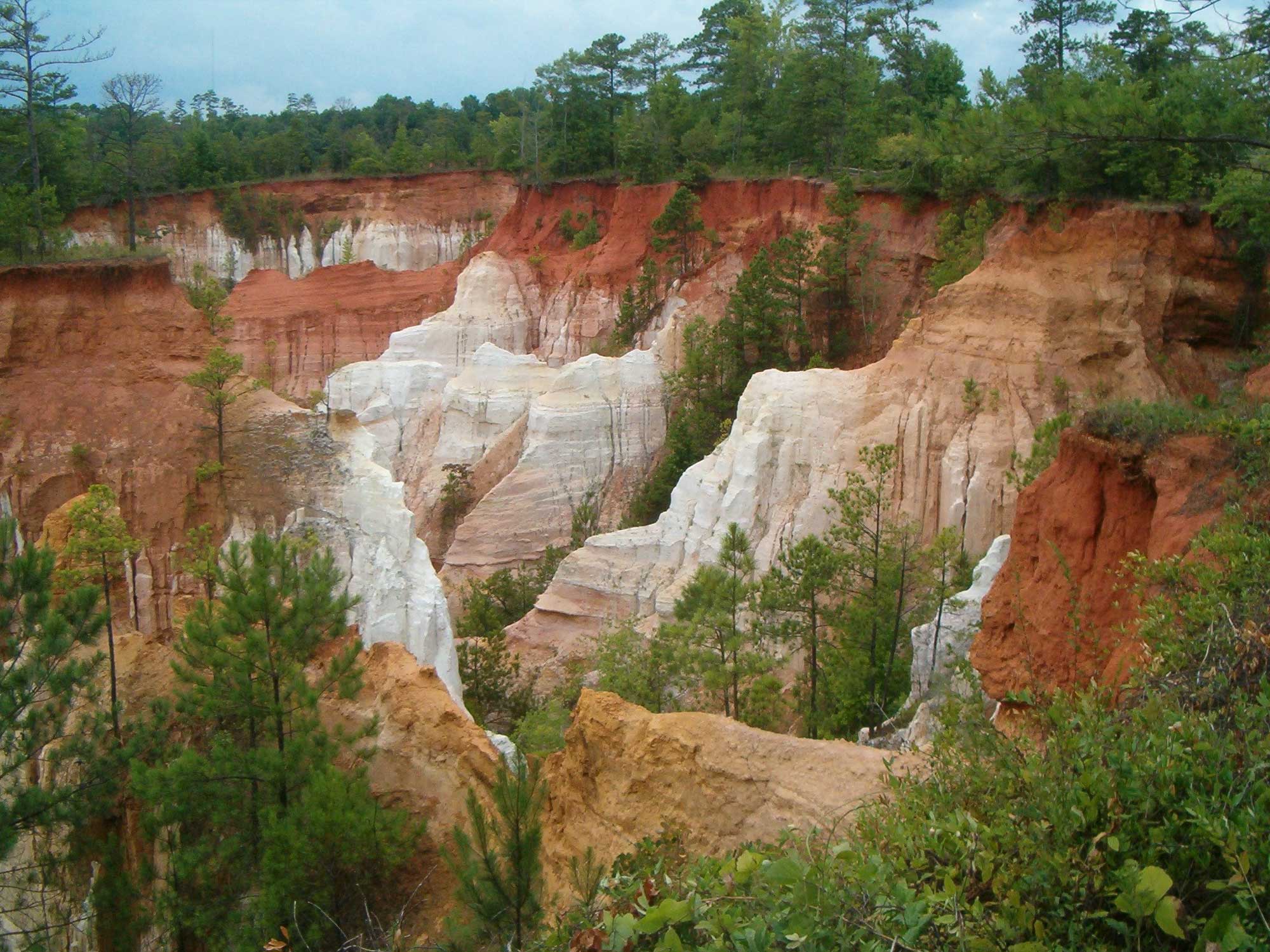
At Providence Canyon State Park in Georgia, the white clays of the Cretaceous Providence Formation are overlain by the red sandstones of the Paleogene Clayton Formation. The gorges that formed this spectacular canyon were created not by natural erosive processes but from poor soil management practices that led to extensive agricultural runoff during the 1800s. Photograph by GPA Photo Archive (Flickr; Creative Commons Attribution-ShareAlike 2.0 Generic license).
Another common characteristic of the K-Pg boundary is the presence of a thin millimeter-scale layer of clay containing a number of rare earth elements, including iridium. Although it is present along the contact zone in many areas of the world, this boundary layer has yet to be documented in either the Gulf or Atlantic Coastal Plain.
Paleogene and Neogene
During the early Paleogene, carbonate deposits (mainly limestone) dominated the Southeast Coastal Plain as far north as North Carolina. However, erosion of the Appalachian Mountains continued throughout the Paleogene and Neogene, resulting in a thick band of gravel, sand, silt, and clay that was in part collected by the Gulf Trough in northern Florida and deposited along the coastal plains of Georgia, the Carolinas, and Virginia. By the end of the Neogene, siliciclastic (non-carbonate) sediment deposits had replaced carbonates as the dominant sediment of the Coastal Plain, transforming the entire area into a peninsula dominated by silts, sands, and clays. Sea level fluctuations shifted shorelines, generating cycles of sand, silt, clay, lignite, and carbonate sediments.
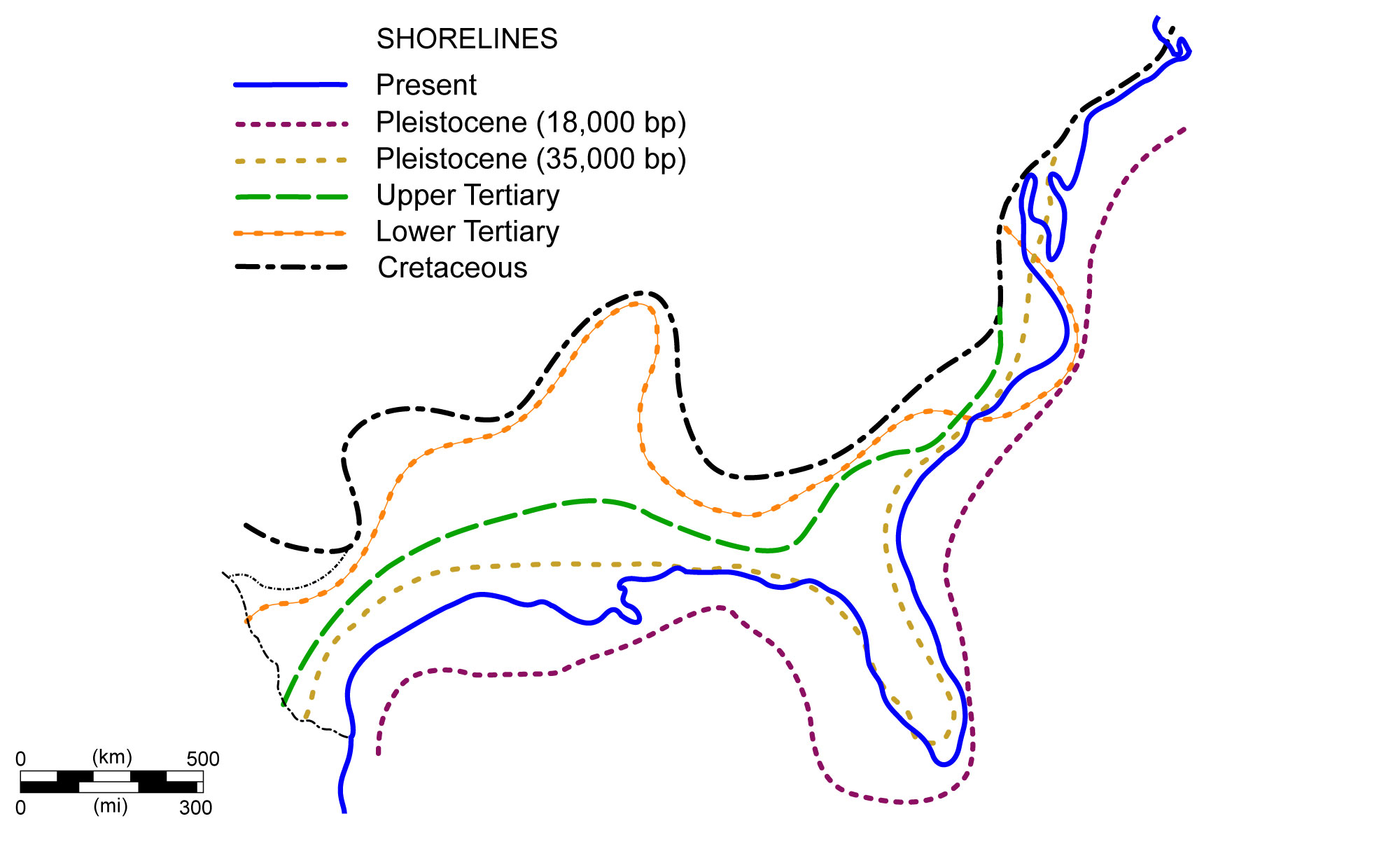
Shoreline positions along the Coastal Plain during the past 70 million years. Image modified from original by NOAA (Wikimedia Commons; public domain).
The Gulf Trough was gradually filled, and the Florida Platform was blanketed with a layer of siliciclastic Appalachian-derived sediment. With the buildup of sand, silt, and clay, the Florida peninsula began to emerge above sea level.
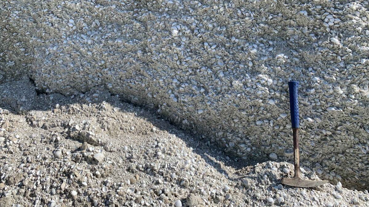
Deposition on the Florida Platform from about 25 million years ago to the present has consisted primarily of siliciclastic sediment, with the exception of the peninsula's southern tip. Carbonate sediment continues to build up on the seaward side of the Florida Keys today, thanks to a warm, subtropical climate and clear, shallow water that allows organisms with carbonate skeletons to thrive and grow. Due to the state's low relief, sea level fluctuations have affected Florida more dramatically than other parts of the Southeast, altering regional environments from shallow lagoons and tidal flats to deep waters and back again. In and after the Neogene, shell beds and fossiliferous sand and limestone were commonly deposited on the Florida Peninsula. When cemented together, these shell beds formed a rock known as coquina.
Coquina layers are quite common in Florida's Neogene rocks, and are dominated by mollusk shells. The shelly rock was quarried and used as a construction material in Florida for over 400 years, and many of the state's historic buildings are made from this stone. Coquina was a favorite material for the building of military forts, as the rock was able to withstand cannon fire.
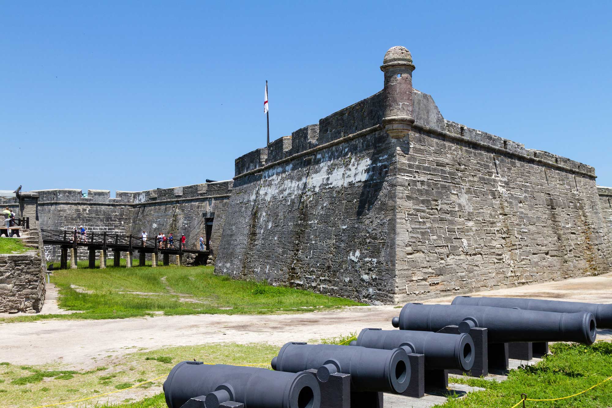
The Castillo de San Marcos, a 17th century fort in St. Augustine, Florida, was constructed from coquina. Photograph by Livio Barcella (Flickr; Creative Commons Attribution-NonCommercial-NoDerivs 2.0 Generic license).
Quaternary
The Quaternary period is recorded in the youngest sediments of the Coastal Plain, and deposits from this time make up much of the sediment found immediately adjacent to modern estuaries, streams, floodplains, and creek beds throughout the Southeast. The ice sheet that repeatedly advanced southward over North America during the Pleistocene never made it to the Southeastern states, but the ice age indirectly left its mark on the area. As glaciers moved over the northern part of the continent, they scraped up the surface and pushed tons of sediment before them like bulldozers. When the climate warmed and ice sheets melted back, sea level rose and meltwater streaming off the retreating glaciers dumped gravel, sand, silt, and clay into streambeds. The Ohio River Valley, which borders much of the Southeast's northern edge, was formed by glacial meltwater. Erratics—boulders, cobbles, pebbles, gravel, and sand carried far from their origin by glacial melt—are also commonly found in the Southeastern states, as sediment from the melting ice was transported through the Ohio River in Kentucky, West Virginia, and down the Mississippi River Valley. The Chickasaw Bluffs adjacent to the Mississippi River formed from glacial sediment (including rock fl our and loess) that was deposited in the Mississippi River Valley when the last ice sheet melted around 10,000 years ago.
A Chickasaw Bluff along the Mississippi River in Tipton County, Tennessee. These features, formed from Pleistocene loess, can be found along the Mississippi River from Hickman, Kentucky all the way to Baton Rouge, Louisiana. Photograph by Thomas R. Machnitzki (Wikimedia Commons; Creative Commons Attribution 3.0 Unported license).
Thick, wind-blown deposits of glacial loess were eroded from the Mississippi River floodplain and cover large swaths of northwestern Alabama. Layers of loess also form the bluffs at Vicksburg, Mississippi, which are up to 24 meters (80 feet) thick in some places. The high ground provided by these bluffs made Vicksburg easily defensible through an extended siege during the Civil War.
At the southern rim of the Florida Platform lie the Florida Keys, a fringe of fossil reefs and associated sediment with living reefs located on the Keys' seaward side. The Florida Keys initially formed during the Pleistocene, when colonies of coral flourished along the edge of the Florida Platform. As sea level rose, the reefs grew upward, and when sea level fell, parts of the coral became exposed and died. Dead reefs became foundations for new coral growth, forming the thick (23–60 meter [75-200 foot]) Key Largo Limestone, which can be seen at the surface of the Florida Keys today. The Miami Limestone, a similar formation, underlies Miami and much of Florida's southern peninsula.
Meteorite Impacts
As in the Inland Basin, meteorite impacts have had an important effect on the geologic structures found within the Southeastern Coastal Plain. The Wetumpka impact structure, estimated to have formed 83 million years ago from the impact of an object 350 meters (1150 feet) in diameter, is a relatively well-preserved feature of Alabama's inner coastal plain. The impact energy from the Wetumpka event is estimated to have had an energy equivalent of 2600 megatons of TNT. Although this sounds large, there is no evidence that the impact had any major local biological effect. The impact structure, which is 7.6 kilometers (4.7 miles) across, has been filled with sediment since the late Cretaceous and is now in the process of being exhumed from Quaternary alluvial sedimentary fill. During the Holocene, the geology of Wetumpka's rim and crater floor has had a strong effect upon the drainage of local streams and the course of the Coosa River. The largest impact crater in the US is located off the coast of Virginia in Chesapeake Bay, and at 85 kilometers (53 miles) across is far larger than Wetumpka. The heat from the impact of a bolide three to five kilometers (two to three miles) in diameter vaporized land, fractured basement rock to depths of 8 kilometers (5 miles), and generated an enormous tsunami that could have reached as far as the Blue Ridge Mountains. Millions of tons of water, sediment, and melted rock were spattered across hundreds of kilometers (miles) of the East Coast. Tektites, natural glass formed from the melted rock, can be found in several areas of the US. In Georgia, tekites from the Chesapeake Bay event are called "georgiaites," and they have modest value as collectibles.
Resources
Resources from the Paleontological Research Institution
Digital Encyclopedia of Earth Science: Minerals: https://earthathome.org/de/minerals/
Earth@Home: Here on Earth: Rocks: https://earthathome.org/hoe/rocks/
Earth@Home Virtual Collection: Rocks: https://earthathome.org/vc/rocks/ (Virtual rock collection featuring 3D models of rock specimens sorted by type.)
Earth@Home: Earth Science of the Northeastern U.S.: Rocks of the Coastal Plain (continues coverage of the Atlantic Coastal Plain in Delaware, Maryland, Massachusetts, New Jersey, and New York): https://earthathome.org/hoe/ne/rocks-cp/
Earth@Home: Earth Science of the South-central U.S.: Rocks of the Coastal Plain (continues coverage of the Gulf Coastal Plain in Arkansas, Louisiana, Missouri, Oklahoma, and Texas): https://earthathome.org/hoe/sc/rocks-cp/