

Page snapshot: South Dakota State Geologic Map; Fossil; 3D models; Rock; Mineral; Gem; Highest and Lowest Elevations; Places to Visit; and Additional Resources.
Image above: Model of Apatosaurus on display at Dinosaur Park in Rapid City, South Dakota. Photograph by Wayne Hsieh (Flickr; Creative Commons Attribution-NonCommercial 2.0 Generic license; image cropped and resized).
Geologic Map of South Dakota
Geologic map of South Dakota showing maximum ages of mappable units. Image by Jonathan R. Hendricks for the Earth@Home project developed using QGIS and USGS data (public domain) from Fenneman and Johnson (1946) and Horton et al. (2017).
South Dakota State Fossil: Triceratops horridus
South Dakota's state fossil is the Cretaceous horned dinosaur Triceratops horridus.
Triceratops skull on display at the South Dakota School of Mines and Technology in Rapid City, South Dakota. Photograph by James St. John (Flickr; Creative Commons Attribution 2.0 Generic license).
3D Models of fossils from South Dakota
Invertebrates
Fossil specimen of the nautiloid cephalopod Eutrephoceras dekayi from the Cretaceous Pierre Shale of the Black Hills of South Dakota (PRI 44557). Specimen is from the collections of the Paleontological Research Institution, Ithaca, New York. Maximum diameter of specimen is approximately 6 cm.
Fossil specimen of the ammonite cephalopod Baculites sp. from the Cretaceous Pierre Shale of Wasta, South Dakota (PRI 70605). Specimen is from the collections of the Paleontological Research Institution, Ithaca, New York. Maximum length of specimen is approximately 8.5 cm.
Fossil specimen of the ammonoid cephalopod Baculites compressus from the Cretaceous Pierre Shale of South Dakota (PRI 44571). Specimen from the collections of the Paleontological Research Institution, Ithaca, New York. Specimen is approximately 15.5 cm.
Fossil specimen (fragment) of the baculite ammonite cephalopod Baculites sp. from the Cretaceous Pierre Shale of Wasta, South Dakota (PRI 70605). Specimen is from the collections of the Paleontological Research Institution, Ithaca, New York. Maximum length of specimen is approximately 7 cm.
Fossil specimen of the ammonite cephalopod Hoploscaphites nebrascensis from the Cretaceous Fox Hills Formation of South Dakota (PRI 76775). Specimen is from the collections of the Paleontological Research Institution, Ithaca, New York. Longest dimension of specimen is approximately 8.5 cm.
Fossil specimen of the bivalve Inoceramus barabina from the Cretaceous Pierre Shale of the Black Hills of South Dakota (PRI 76764). Specimen is from the collections of the Paleontological Research Institution, Ithaca, New York. Longest dimension of specimen is approximately 6 cm.
Vertebrates
Fossil specimen of a Merycoidodon culbertsoni oreodont skull from the Oligocene of South Dakota (PRI 50653). Specimen is on display at the Museum of the Earth, Ithaca, New York.
Toe bone from a duck-billed dinosaur (hadrosaur, possibly Edmontosaurus) from the Cretaceous of South Dakota (PRI 42981). Specimen is from the research collections of the Paleontological Research Institution, Ithaca, New York. Length of toe is approximately 8.5 cm.
Plants
Petrified fossil specimen of the palm Palmoxylon cheyennense from the Cretaceous Pierre Formation near the Black Hills, South Dakota. Palm trees are monocots and do not produce true wood. Instead, the trunk of a palm has many vascular bundles (the vascular bundle caps look like black dots on the above specimen) in a matrix of ground tissue. Specimen is from the Cornell University Paleobotanical Collection (CUPC), Ithaca, New York (#1656). Length of rock is approximately 5.5 cm.
Fossil angiosperm leaf from the Cretaceous Dakota Sandstone of south central Minnesota. Specimen is from the Cornell University Paleobotanical Collection (CUPC), Ithaca, New York (#2076.10). Length of specimen is approximately 12.5 cm.
South Dakota State Rock: None
South Dakota does not have an official state rock. What do you think it should be?
South Dakota State Mineral: Rose quartz
This silicate mineral is found in great quantities throughout the Black Hills. It was first discovered there in 1875, and the Scott Rose Quartz Mine was opened in 1902.
Sample of Rose quartz from the Precambrian of the Black Hills of South Dakota. Photograph by James St. John (Flickr; Creative Commons Attribution 2.0 Generic license).
South Dakota State Gem: Fairburn agate
These colorful silicate minerals are named for a locality near Fairburn, South Dakota, where they were originally discovered. The Fairburn agate is notable for its variety of colorful, strikingly contrasted, thin red, pink, white, and yellow bands.
Sample of Fairburn agate from South Dakota. Photograph by James St. John (Flickr; Creative Commons Attribution 2.0 Generic license).
South Dakota's Highest and Lowest Elevations
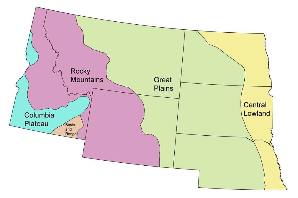
Topographic map of South Dakota with physiographic regions and point of highest elevation identified. Topographic data are derived from the Shuttle Radar Topography Mission (SRTM GL3) Global 90m (SRTM_GL3) (Farr, T. G., and M. Kobrick, 2000, Shuttle Radar Topography Mission produces a wealth of data. Eos Trans. AGU, 81:583-583).
Highest Elevation: Black Elk Peak
South Dakota’s highest point is Black Elk Peak (formerly Harney Peak), an exposed granitic edifice in the Black Hills just six kilometers (four miles) southwest of Mount Rushmore. The mountain, which has an elevation of 2208 meters (7244 feet), was first seen by European-Americans when General George Armstrong Custer climbed it in 1874.
Fire tower at the top of Black Elk Peak. Photograph by "Whitney" (Flickr; Creative Commons Attribution-NonCommercial 2.0 Generic license).
Lowest Elevation: Big Stone Lake
South Dakota’s lowest point is Big Stone Lake, which lies at 294 meters (965 feet) above sea level and is located in the northeastern corner of the state on the Minnesota border.
Places to Visit
Plesiosaur skeleton on display at the Museum of Geology at the South Dakota School of Mines & Technology. Photograph by Ellen Macdonald (Flickr; Creative Commons Attribution-NonCommercial-NoDerivs 2.0 Generic license).
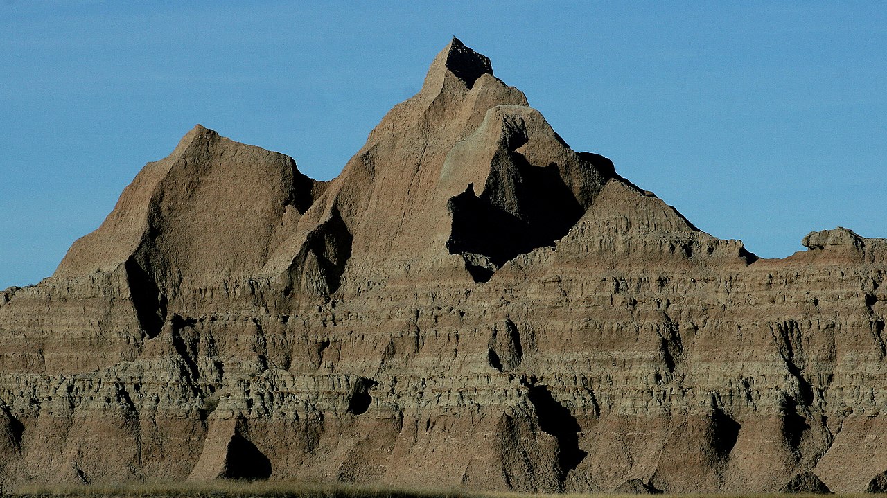
The Brule Formation, exposed in Badlands National Park, is a sequence of fine-grained mudstones, claystones, and siltstones interbedded with freshwater carbonate rock, volcanic ash, and sandstone. These sediments were deposited during the Oligocene, 34-30 million years ago. Photograph by Lee McDowell, National Park Service (Wikimedia Commons; public domain).
Additional resources
Earth@Home resources about South Dakota and nearby states:
- Rocks: Great Plains, Central Lowland
- Fossils: Great Plains, Central Lowland
- Topography: Great Plains, Central Lowland
- Energy: Great Plains, Central Lowland
- Mineral Resources: Great Plains, Central Lowland
Earth@Home resources about the Northwest Central region of the United States: